


What were the impacts of Indigenous–colonizer interactions on Indigenous social and political institutions? What kinds of impacts did early Spanish entradas have on the formation, livelihoods, vibrancy, maintenance, and dissolution of Indigenous towns in the American Southeast and on broader sociopolitical arrangements? It is only recently that developments in chronological methods have allowed such questions to be asked by archaeologists. Previous work relied on coarse timelines scaffolded to the presence, absence, or frequencies of specific archaeological materials. The precise histories of Indigenous towns, institutions, and postcontact movements and demographics generally remained out of reach. In turn, the absence of detailed absolute timelines has fostered the use of totalizing “grand narratives” (sensu Voss Reference Voss2015) of Indigenous collapse in the wake of Spanish arrival. Indeed, a lexicon of “collapse” (Hally Reference Hally2008; Smith Reference Smith, Hudson and Tesser1994, Reference Smith2004), wreckage, “destabilization” (Ethridge and Hudson Reference Ethridge, Hudson, Hill and Beaver1998), “shatter” (Ethridge and Shuck-Hall Reference Ethridge and Sheri2009), and “ashes” (Hahn Reference Hahn2004) has been primarily used to describe postcontact changes observed among Indigenous societies.
This language is not the result of concerted efforts to center narratives of collapse per se but rather has been the ultimate result of how little we have been able to resolve between 1540 and 1700 in the absence of precise chronological control. We have been limited to scarce, incomplete, or coarse documentary and archaeological evidence and tenuous reconstructions of population movements, demographic change, and institutional transformations based sometimes solely on, for instance, ceramic types, while the presence or absence of European materials has been used as the primary clock by which temporality is estimated. These limits to research have greatly influenced our historical narratives of Indigenous–colonizer interactions and the kinds of theoretical and conceptual frameworks we have been able to bring to bear on these critical anthropological and historical questions. As of yet, we lack measurements for temporality that match the human experience of these processes of change. This study seeks to contribute to remediating this deficiency.
The King site in northwestern Georgia is one of the most fully excavated sixteenth-century Indigenous towns in the southeastern United States (Figure 1). It is also one of the most well-excavated Indigenous towns occupied during some of the earliest European expeditions into the interior of eastern North America. Home to ancestors of citizens of the Muscogee Nation, King serves as an important analytical microcosm to explore the direct and indirect impacts of the earliest encounters between Indigenous peoples and Spanish colonizers and to link the deep Indigenous sociopolitical history of the region both to these encounters and subsequent political transformations.
Map of the southern Appalachia region indicating location of the King site and other southern Appalachian sites mentioned in the text. (Color online)

Figure 1 Long description
The map of southern Appalachia highlights various Indigenous sites across Tennessee, Georgia and Alabama. Key sites include King (9FI5) in northwestern Georgia, marked with a large star, indicating its significance. Other sites are marked with smaller stars, such as DeArmond (40RE12), Bat Creek (40LD24), Martin Farm (40MR20) and Toqua (40MR6) in Tennessee. In Georgia, sites like Etowah (9BR1), Long Swamp (9CK1) and Wilbanks (9CK5) are shown. The map also features major reservoirs like Watts Bar, Tellico and Allatoona, with rivers and basins such as the Chickamauga Basin and Nickajack Reservoir. The map includes a scale bar indicating distances up to 50 kilometers and a north arrow for orientation.
The King site is argued to be the location of the town of Piachi, whose residents engaged with both De Soto in 1540 and Pardo in 1566; however, its primary occupation has been traditionally estimated to have lasted for no more than 35–50 years, between about AD 1535 and 1570 (Hally Reference Hally2008). These estimates are based on Indigenous ceramic typologies, the presence and absence of European materials, and an analysis of architectural lifespans. Because of this site’s importance in understanding both the conditions preceding contact with colonizers and the subsequent impacts of these interactions, we undertook an absolute dating program to reveal a microhistory of Piachi and shed light on the processes underlying these critical encounters. Based on 58 new AMS dates from features, including high-resolution tree-ring-radiocarbon analyses of 10 preserved house posts, we reconsider the internal history of Piachi and use these new temporalities to recast narratives of Indigenous–colonizer dynamics, subsequent population movements, and institutional change across the region.
Chronologies and Archaeological Narratives
We draw inspiration from work across social and historical disciplines that addresses how we construct narratives of culture contact. More specifically, this work engages with the epistemological challenges of using archaeological data to tell histories. The body of theory we link to explores the ways that the coarse temporality of archaeological data and a reliance on materiality often contribute to the creation of totalizing, essentializing grand narratives that dehumanize the experiences of past peoples and contribute to reproducing the colonial scaffolding on which we illuminate Indigenous histories. Importantly, a critical outcome of these processes is often the compartmentalization of Indigenous histories into blocks of time, thereby obfuscating continuity and disenfranchising modern descendant communities of deep, ancestral pasts and places.
In reviewing the effects of grand narratives on our collective understandings of both past and present worlds, Voss (Reference Voss2015:353) points out that the slippage between representative narratives and the actual outcomes of historical encounters is what makes narratives so politically powerful, because stories are what shape our perceptions of the world. Grand narratives appeal to desires for logic and order; they close off alternative narratives or subsume other narratives under themselves; and of course, they compete with other narratives for legitimacy (Voss Reference Voss2015:354). Grand narratives “share in the way they close down, rather than open up, meaningful directions for research” (Voss Reference Voss2015:354): they continue to contribute to views on Indigenous histories rooted in outdated, biased perspectives that deny complexity, agency, and independence to the postcontact Indigenous worlds of the Americas (see also Gonzalez and Panich Reference Gonzalez, Panich, Panich and Gonzalez2021; Labelle Reference Labelle2013; Panich Reference Panich2020; Schneider Reference Schneider2021; Schneider and Panich Reference Schneider and Panich2022; Silliman Reference Silliman, Oland, Hart and Frink2012, Reference Silliman2020; Thompson, Williams, et al. Reference Thompson, Williams, Golya, Garland, Broadbent, Schroder and Sampson2026).
Essentialized material typologies that collapse meaningful social histories into neat chronological units may be one of the largest contributors to such grand narratives. Because such typologies remain omnipresent in studies of colonial encounters, the materiality of such encounters is often “reduced to the mere description of Indigenous versus European artifacts” (Keehnen et al. Reference Keehnen, Hofman, Antczak, Hofman and Keehnen2019:11), descriptions that are then leveraged to support totalizing narratives. The direct counter to the use of reified material-chronological descriptive units is the development of fine-scale chronologies via absolute dating. As Keehnen and coauthors (Reference Keehnen, Hofman, Antczak, Hofman and Keehnen2019:2) highlight, “Efforts to disrupt the many and long persistent ‘Grand Narratives’ of European colonialism (sensu Voss Reference Voss2015) and to decolonize archaeology by recognizing long-term Indigenous trajectories in fine-grained views of history (Oland et al. Reference Oland, Hart and Frink2012) continue to be successful.” Indeed, the development of new radiocarbon dating techniques and analytical methods, and their facilitation of the use of calendrical ages, are continuing to serve as a counter to traditions of postcontact (and precontact) Indigenous erasure in North American archaeology (Birch et al. Reference Birch, Manning, Sanft and Conger2021; Holland-Lulewicz et al. Reference Holland-Lulewicz, Thompson, Wettstaed and Williams2020; Manning and Hart Reference Manning and Hart2019; Panich and Schneider Reference Panich and Schneider2019; Thompson et al. Reference Thompson, Holland-Lulewicz, Butler, Hunt, Wendt, Wettstaed, Williams, Jefferies and Fish2022); these techniques even have the potential to facilitate the exercise of sovereignty over key histories and heritage by modern descendant Tribal Nations (Birch Reference Birch2022; Birch et al. Reference Birch, Hunt, Lesage, Richard, Sioui and Thompson2022). These methodological advances enable a critical epistemological turn in the treatment of archaeological data and the production of archaeological narratives.
The assumptions we build into our chronological narratives have crucial effects on how we construct social histories (Holland-Lulewicz Reference Holland-Lulewicz2021). The culture-historic practice of building neat chronological units characterized by material homogeneity obscures notions of temporality, even though change can be heterogeneous and characterized by multiple rhythms of timing, interlaced cadences of long notes, and punctuating beats. In studying colonial encounters, these rhythms are often overlooked in favor of chronologies rooted in material assumptions, especially the presence or absence of European materials. Panich and Schneider (Reference Panich and Schneider2019) recently illustrated how the use of reified archaeological periodizations effectively resulted in the erasure of dozens of sites from the California archaeological record that are crucial for understanding Indigenous persistence in the face of repeated encounters with Euro-American colonists.
In eastern North America in particular, glass trade beads and European metal artifacts have been heavily relied on for the construction of chronological frameworks and the interpretation of colonial encounters. In traditional interpretations in which such materials are absent, either Europeans did not come to Indigenous sites or those settlements were depopulated before contact. In southern Ontario and upstate New York, using about 100 new radiocarbon dates and sophisticated Bayesian modeling, Manning and coauthors (Reference Manning, Birch, Conger, Dee, Griggs, Hadden and Hogg2018) demonstrated the unreliability of using the presence and frequency of European materials to date Indigenous settlements and to build postcontact Indigenous landscape histories. In central Georgia, Holland-Lulewicz and colleagues (Reference Holland-Lulewicz, Thompson, Wettstaed and Williams2020) used radiocarbon dating to demonstrate that, contrary to narratives of Indigenous collapse, classic religious and political institutions tied to the construction and use of earthen platform mounds continued up to 130 years after initial contact with Spanish colonizers. Such endurance and survivance had been overlooked because of the absence of European materials in these spaces, even though consultation with descendant communities has indicated that these were not spaces where one might expect non-Indigenous or exotic materials to be present (Holland-Lulewicz et al. Reference Holland-Lulewicz, Thompson, Wettstaed and Williams2020). Alternatively, recent work dating the timing of the introduction of peaches across the American Southeast has demonstrated the adoption of European materials sometimes far preceding any contact with Spanish colonizers, highlighting the agency and selective adoptions of materials through Indigenous networks (Holland-Lulewicz et al. Reference Holland-Lulewicz, Thompson, Thompson, Butler, Chavez, Franklin, Hunt, Williams and Worth2024). These studies set a stage for the complete reassessment of the role of European contact in changing Indigenous societies.
When we reject narratives scaffolded on the Indigenous passive adoption of European materials, space opens for research intended to explore the character of specific colonial encounters and entanglements. Using this approach, this study builds a detailed history of an Ancestral Muskogean town as a way to subvert such grand narratives and finely track the Indigenous materiality (in the form of demographic and institutional change) of first encounters with Spanish colonizers.
Based on excavations, house floor re-buildings, ceramic styles, a negligible number of European artifacts, and four radiocarbon dates with error ranges of a century or more, Piachi is currently estimated to have been occupied for a mere 40–50 years, between AD 1535 and 1575. This estimate for the timing and temporality of Piachi forces a particular narrative onto interpretations of its life history, its residents’ postcontact experiences, and the regional sociopolitical processes underlying and affected by these Indigenous–colonizer dynamics. It has been assumed that all residents moved to the town at the same time, that the palisade and council houses were built with the founding of the town, and that encounters with Spanish colonizers led to its rapid depopulation, coeval with the “collapse” of the wider Coosa Paramountcy. The implications of the new chronologies presented here are thus critical for either confirming these hypotheses or reframing the historical narrative not only of Piachi but also of the postcontact social and political landscape more broadly, potentially challenging grand narratives of “collapse” and “shatter” and providing more detailed insights into Indigenous institutional responses to Spanish colonization.
The Ancestral Muskogean Town at King
The King site, the likely location of the sixteenth-century town of Piachi (Hudson et al. Reference Hudson, Smith, Hally, Polhemus and DePratter1985:729; but see Mathews Reference Mathews1984:83–84, Reference Mathews and Blakely1988:115), is the most extensively and meticulously excavated site in southern Appalachia that spans the initial Spanish intrusion into the region (Blakely Reference Blakely1988; Hally Reference Hally2008; see Figure 2). Located in northwestern Georgia, Piachi is a classic example of dozens of similar towns that dotted the landscape at this time (Bourne Reference Bourne and Bourne1922:113; de Oviedo Reference de Oviedo1959:171; Hally Reference Hally1975, Reference Hally and Blakely1988, Reference Hally2008; Hudson et al. Reference Hudson, Smith, Hally, Polhemus and DePratter1985; Mathews Reference Mathews1984, Reference Mathews and Blakely1988; Smith 1968:78). Regionally, researchers have argued for a significant period of social and political flux, characterized by population movements, complex demographic changes caused by introduced diseases and subsequent coalescence, the collapse of Indigenous polities, and the eventual emergence of the formal Creek Confederacy in the eighteenth century (Ethridge and Hudson Reference Ethridge, Hudson, Hill and Beaver1998; Foster Reference Foster2007; Hahn Reference Hahn2004; Hall Reference Hall2001; Hally Reference Hally, Hudson and Tesser1994; Knight Reference Knight, Hudson and Tesser1994; Milanich Reference Milanich1992; Smith Reference Smith1987, Reference Smith, Hudson and Tesser1994, Reference Smith2000, Reference Smith2004).
Map of the King site. Features dated in this study are highlighted in blue. Numbers refer to numbered structures. (Color online)

Roughly 60%–70% of Piachi has been excavated (see Hally Reference Hally2008). It covers about 2 ha and consists of at least 28 households across 42 domestic structures; an encompassing 1,300-foot ditch and palisade; about 250 buried ancestors; a planned, rectangular settlement layout with an open plaza; and a large public building representing a council house. Piachi was one of five or six large towns along the Upper Coosa River that likely made up a single political entity. This polity would have been subsumed under what archaeologists and ethnohistorians have described as the Coosa Paramountcy, a loose network of politically affiliated towns stretching about 500 km from northeastern Tennessee down through northern Georgia and into central Alabama (Hudson et al. Reference Hudson, Smith, Hally, Polhemus and DePratter1985; Smith Reference Smith2000). The depopulation of Piachi was hypothesized to have occurred at the same time as the sixteenth-century depopulation of this region and the supposed “collapse” of the Coosa political network (Hally Reference Hally, Hudson and Tesser1994, Reference Hally2008; Smith Reference Smith1987, Reference Smith2000).
All current estimates have assigned an occupational history of 50 years at most, between 1530 and 1580 or so (Hally Reference Hally and Blakely1988, Reference Hally2008; Hudson et al. Reference Hudson, Smith, DePratter and Kelley1989; Smith Reference Smith1987). These estimates are based on a combination of artifact typologies (both Indigenous and European), settlement patterns, ethnohistoric accounts, and four radiocarbon dates (Hally Reference Hally2008). Indeed, the lack of a substantive assemblage of European materials is one of the main lines of evidence that has been used to support the depopulation of Piachi sometime soon after De Soto’s expedition through the region. Across the entire site, just nine European artifacts have been recovered: they include celts, knives, chisels, a rod, and a sword (Hally Reference Hally2008; Smith Reference Smith1987).
In addition to European artifacts, bioarchaeological evidence for Spanish-induced wounds and fatalities has been used to link the occupation at King to that of the ethnohistorically known towns of either Piachi or Ulibahali (Hudson et al. Reference Hudson, Smith, DePratter and Kelley1989; Mathews Reference Mathews and Blakely1988; Smith Reference Smith1987). As reported by Mathews (Reference Mathews and Blakely1988), 20% of the population at Piachi were either wounded or killed by violence, and an additional 13% received wounds that would have been undeniably fatal, with a total estimate of 60 individuals killed as a result of violent encounters with De Soto’s expedition. Roughly 6% of burials are either mass or multiple burials, more than double the proportion of any other contemporary town in the region (Smith Reference Smith1987). Although this line of evidence has been a key component of narratives that define the Indigenous–colonizer encounters at Piachi and the subsequent depopulation of the town and collapse of Coosa, Milner and coauthors (Reference Milner, Larsen, Hutchinson, Williamson and Humpf2000), in a reanalysis of this evidence, found no indication of any damage caused by sixteenth-century European weapons, instead noting damage from rodent incisors.
Regardless of the evidence for violence, known disease outbreaks have also been cited as supporting evidence for the mid- to late sixteenth-century depopulation of the town. As outlined by Smith (Reference Smith1987), there were at least 12 disease outbreaks recorded for La Florida between 1513 and 1599, and at least five more were recorded between 1600 and 1673. One of the most severe occurred between 1564 and 1570, at the same time as the archaeologically estimated depopulation of Piachi. That said, there were no direct, substantive European encounters or expeditions into this region between 1568 and the 1670s, and thus no direct evidence for corroborating the timing of this proposed depopulation. Further, Milner (Reference Milner1980) hypothesized that a substantive interpolity transmission of diseases—for example, from Florida all the way to northern Georgia—would be unlikely in the absence of mass refugee movements.
Using all these lines of evidence—archaeological, ethnohistoric, and historic—with particular attention to the internal occupational history of the King site, Hally (Reference Hally2008) proposed a general timeline for the town as follows:
1. Given the location of Piachi toward the extreme western extent of the Coosa polity, the town was likely the last town to be added to the Coosa political alliance, several decades after the polity was established, potentially by residents moving to the town from other, growing towns in the Coosa network.
2. At this initial point, the town was settled by a small number of people, likely three to four households. It is unclear when Hally (Reference Hally2008) estimates this initial timing to have occurred, but it was likely 1535.
3. Right around the time of initial settlement, the public structure (Structure 17) and the defensive features (ditch and palisade) were constructed.
4. Over the next one to two decades, the town grew steadily. Hally’s (Reference Hally2008) exact timing of this is unclear but was likely between about 1535 and 1550. He did distinguish between the town’s complete occupation and its “formal” occupation, with the formal occupation estimated to be between 1535 and 1570.
5. Sometime around 1570, based on analogy with processes recorded ethnohistorically and historically, Hally (Reference Hally2008) argues that the town was ceremonially decommissioned.
6. Although the “formal” occupation is argued to have ended around 1570, Hally (Reference Hally2008) proposes that a handful of houses (at least five) continued to occupy the location until sometime after 1570.
The King site has thus provided one of the most valuable and most-cited opportunities to contribute insight into the temporality of the postcontact Indigenous landscape of the American Southeast. Specifically, a detailed archaeological record, a robust ethnohistoric corpus, its straddling the threshold of initial Spanish contact, its representativeness of sixteenth-century towns, and its embeddedness in the tides of regional demographic and political processes have made the King site one of the most critical sites for resolving the temporalities of the impacts of Spanish colonization on Indigenous communities and for reorienting theoretical approaches to these important anthropological challenges. That said, all these contributions, as well as the broader narratives we are able to derive from King’s archaeological record, hinge on the chronological framework used to delineate its occupational history. In what follows we present a program of absolute, high-resolution AMS dating and Bayesian chronological modeling to situate both the internal chronology and broader regional and historical articulations of this southern Appalachian town.
Data and Methods
Radiocarbon Dating
Two of the major challenges facing chronology building for the contact period across North America are the shape and structure of the available radiocarbon calibration curve. The very nature of past 14C concentrations and our current resolution of changes to these concentrations have yielded radiocarbon ages for the sixteenth century that span hundreds of years. With the advent of new laboratory and statistical methods, however, these challenges can now sometimes be overcome. Indeed, Thompson and coauthors (Reference Thompson, Jefferies and Moore2019) explicitly outline the utility of radiocarbon dating and advanced statistical modeling to resolve temporalities that fall on these parts of the calibration curve. Across North America, such methodologies have continuously proven successful for illuminating these contact period histories (e.g., Birch et al. Reference Birch, Manning, Sanft and Conger2021; Hill et al. Reference Hill, Beck, Lengyel, Trabert and Adair2018; Holland-Lulewicz et al. Reference Holland-Lulewicz, Thompson, Wettstaed and Williams2020; Manning and Hart Reference Manning and Hart2019; Manning et al. Reference Manning, Birch, Conger, Dee, Griggs, Hadden and Hogg2018, Reference Manning, Jennifer, Megan, Michael, Carol and Carla2019, Reference Manning, Birch, Conger and Sanft2020; Manning, Huey, et al. Reference Manning, Huey, Lucas and Hart2021; Manning, Lorentzen, and Hart Reference Manning, Lorentzen and Hart2021; Thompson et al. Reference Thompson, Jefferies and Moore2020).
In addition to incorporating contextual information into the refinement of dates, tree-ring-radiocarbon dating, or “wiggle-matching,” has also proven to be key in resolving temporalities and is leveraged here (Bronk Ramsey et al. Reference Bronk Ramsey, van der Plicht and Weninger2001). In wiggle-matching, successive 14C measurements are made along a tree-ring sequence (e.g., from a large piece of charcoal or a preserved wooden post). Because the time interval—the number of rings/years—between each measurement is known, the sequence can be precisely matched to historical variability in atmospheric 14C content. Tree-ring-radiocarbon dating produces age estimates for tree rings that can far exceed the precision of single measurements on short-lived organisms and is regarded as the most effective and efficient means for high-resolution dating of archaeological material (Bayliss et al. Reference Bayliss, Marshall, Dee, Friedrich, Heaton and Wacker2020; Galimberti et al. Reference Galimberti, Ramsey and Manning2004; Pearson et al. Reference Pearson, Leavitt, Kromer, Solanki and Usoskin2022). This technique allows high-resolution (error <10–20 years) dating to proceed on archaeological charcoal even in the absence of a regional tree-ring chronology. This is especially important for the King site, where dozens of intact wooden posts have been recovered. Previous work used 10 of these posts to construct a 157-year floating tree-ring chronology (Grissino-Mayer and Hally Reference Grissino-Mayer and Hally2017), but until now, there was no way to effectively anchor this chronology in real time. In many global case studies, tree-ring-radiocarbon dating has proven effective for anchoring floating tree-ring chronologies while providing high-resolution dates for empirical chronologies (Grabner et al. Reference Grabner, Wächter, Nicolussi, Bolka, Sormaz, Steier and Eva Maria2021; Hogg et al. Reference Hogg, Gumbley, Boswijk, Petchey, Southon, Anderson, Roa and Donaldson2017; Kessler et al. Reference Kessler, Welch, Butler, Brennan, Towner and Hodgins2022; Park et al. Reference Park, Kim, Jeong, Kim, Jung-Ae, Park, Choi, Park and Seo2010; Pearson et al. Reference Pearson, Brewer, Brown, Heaton, Hodgins, Jull, Lange and Salzer2018; Turkon et al. Reference Turkon, Manning, Griggs, Ramírez, Nelson, Padilla and Wild2018). Unfortunately, we were unable to re-create Grissino-Mayer and Hally’s (Reference Grissino-Mayer and Hally2017) floating tree-ring chronology but were able to produce precise age estimates for 10 posts.
To empirically anchor the chronology of Piachi to a high-precision absolute timeline, we analyzed 58 new AMS dates from across 14 contexts (Table 1): 12 domestic structures (houses), a public house (or council house), and the ditch surrounding the town (associated with the palisade). Of these 58 dates, 31 were used for tree-ring-radiocarbon dating to yield precise age estimates for the outermost growth ring of 14 wood specimens. A total of eight tree-ring-radiocarbon dates were obtained for rings from four pieces of charcoal and uncharred wood fragments, and another 23 dates were derived from 10 intact wooden posts. The remaining 27 dates were obtained on pieces of charred nut, charred wood, or uncharred wood. The final dataset thus consisted of 39 modeled age determinations across 14 contexts. Materials dated include 11 specimens of wood charcoal (two wiggle-matched, nine single rings), four specimens of uncharred cedar wood (two wiggle-matched, two single rings), 10 intact cedar posts (wiggle-matched), 13 pieces of charred hickory nut, and two pieces of charred walnut. AMS dates on single samples and charcoal wiggle-matching were run at the Pennsylvania State University Radiocarbon Lab within the Institute for Energy and the Environment. Tree-ring analyses and wiggle-matching on preserved posts were undertaken at the University of Arizona Laboratory for Tree Ring Research.
AMS Dates Used in This Study.

Table 1 Long description
The table lists AMS radiocarbon results by lab ID, excavation provenience, and material type, with radiocarbon ages and calibrated calendar ranges at two confidence levels. Materials include mostly wood charcoal and charred hickory nut, plus some cedar wood and tree-ring wood samples. Calibrated ranges cluster mainly in the late thirteenth through mid fifteenth centuries for many wood and tree-ring samples, and in the sixteenth through seventeenth centuries for many nut and some charcoal samples. The latest calibrated ranges extend into the eighteenth century, including a Structure 21 hearth sample calibrated to the mid seventeenth through late eighteenth centuries. Several entries are marked with an asterisk indicating they were used in separate wiggle-matching sequences and their modeled ages were carried forward rather than being directly used in the main model. A small set of dagger-marked tree-ring dates calibrate much earlier, roughly the eleventh to early thirteenth centuries, and were treated as outliers not used in the primary model. Overall, the dataset supports multiple activity phases, with most dated contexts falling between about AD 1290 and 1650, while noting that some dates were handled differently in modeling.
Notes: Dates marked with an asterisk (*) were modeled in individual D_Sequence models for wiggle-matching. Single modeled ages from these D_Sequences (wiggle-matching; one modeled age per wood sample) were saved as priors and included in the primary model (see Table 2). These individual dates marked with an asterisk were thus not directly included in the primary model. Dates marked with an (†) were exceptionally early and were not incorporated into the primary model.
Chronological Modeling
Bayesian statistics allow us to “analyze new data we have collected about a problem in the context of our existing experiences and knowledge about that problem”; by doing so, we can “arrive at a new understanding of the problem which incorporates existing understandings about the problem and our new data” (Bayliss Reference Bayliss2007:76). When using the associated terminology, new data or observations can be referred to as likelihoods. Existing experiences and knowledge are referred to as prior beliefs, a priori information, or priors. The understandings we achieve from incorporating our prior beliefs into the analysis of new data are understood to be posterior beliefs.
Bayesian statistics are uniquely situated for the analysis of radiocarbon data because of their focus on probabilities. Given that extensive overviews of Bayesian analysis of radiocarbon dates have been published by experts in the technique (e.g., Bayliss Reference Bayliss2007, Reference Bayliss2015; Bayliss et al. Reference Bayliss, Ramsey, Van der Plicht and Whittle2007; Bronk Ramsey Reference Bronk Ramsey2009a; Buck et al. Reference Buck, Cavanagh and Litton1996; Whittle et al. Reference Whittle, Healy and Bayliss2011), only a brief introduction and relevant explanations/definitions are provided here. The results of “scientific dating are always interpreted contextually” and Bayesian statistics “provide an explicit, quantitative method which can combine raw dates with other prior information included in a model to produce formal statistical date estimates which combine both sets of evidence” (Bayliss Reference Bayliss2007:77). All models were built using OxCal v 4.4 (Bronk Ramsey Reference Bronk Ramsey2009a) and the IntCal20 calibration curve (Reimer et al. Reference Reimer, William E. N., Edouard, Alex, Paul G., Christopher Bronk and Martin2020). Age ranges produced in these models are presented in italics to distinguish them from nonmodeled ages and are rounded to the nearest five.
In this study, all dates were included in a simple, single-phase model with start and end boundaries, wherein all dates were assumed to involve the same event: the occupation of Piachi at the King site. Within this phase, dates associated with the same features or structures were further included in subphases that represented those events: the occupations (buildings and re-buildings) of individual houses. In total, the King site model included one all-encompassing phase populated with individual phases representing 14 distinct contexts from across the site. Unfortunately, the extensive, horizontal excavation strategy did not yield useful stratigraphic relationships that could be used as priors in the model.
In addition to individual dates, 14 wiggle-matched age determinations were also incorporated into the model. As described earlier, the process involves extracting two or more samples from a single piece of charcoal or wood where the number of tree rings between the samples are known. The D_Sequence command in OxCal uses this information to produce a single, modeled age for the terminal year of growth for the sample. Fourteen D_Sequences were modeled independently to produce more precise ages for 14 of the wood and post specimens. Dates produced by these D_Sequence models were saved as priors and then incorporated into the overall site-wide model.
Three kinds of outlier models were applied to the primary model: a charcoal outlier model, a general outlier model, and a ring loss model. A full review of the kinds of outliers and outlier models that may be applied in Bayesian analyses for archaeological applications can be found in Bronk Ramsey (Reference Bronk Ramsey2009b). Outlier models are used to “determine whether there are problematic determinations that do not agree with the prior framework” (Higham et al. Reference Higham, Douka, Wood, Ramsey and Brock2014:Supplemental Material p. 6). The model output is thus affected by the downweighting of specific determinations based on the modeled fit of each outlier.
Charcoal outlier models were used on determinations made on charcoal samples that were not subject to wiggle-matching (see the later discussion). A general outlier model was applied to each noncharcoal date included in the models. This is especially important as a check on model fit (for all likelihoods), because agreement indices are not useful when employing outlier models. See Bronk Ramsey (Reference Bronk Ramsey2009b) for a detailed summary and mathematical basis for each of these types of outlier models. A ring loss model was applied to each of the four wiggle-matched posts. Following Kessler and coauthors (Reference Kessler, Hodgins, Stambaugh and Adair2021), this outlier model statistically adjusts the posterior probability distributions for these samples based on predicted tree-ring loss, because none of the outermost rings in our sample are preserved.
Partly because of the lack of ordinal priors—knowledge about the ordering of dates in a sequence, as provided by stratigraphic information—the resulting model still resulted in posterior probability distributions for individual dates that exhibited multiple intercepts along the calibration curve. This means that some modeled ages continued to produce long ranges at reversals and plateaus in the calibration curve. Thus, in addition to this primary model, we built an alternative model that had the same structure as our primary model but that included only dates whose posterior probability distributions in the primary model exhibited a single peak at the 68% interval. All modeled age ranges with a single peak from the primary model were saved as priors and incorporated as new likelihoods in the alternative model. These procedures likely biased our alternatively modeled age ranges of Piachi’s earlier occupations, as dates exhibiting multiple intercepts were those dating to the latest portion of the occupation. Because later ages are most likely to be those whose multiple intercepts are more likely to be unresolved, and thus excluded from this sensitivity analysis, we consider the results from the alternative model as a robust terminus post quem (TPQ), or earliest possible age range, after which Piachi was depopulated.
Finally, to assess the internal occupational history of Piachi, we used the “order” command in OxCal. This command calculates/queries the relative chronological probabilities of a series of events within the model; that is, it is used to calculate the probability that Date A occurred before Date B. We applied this to our entire model, calculating the probabilities of order for every pair of dates included in the model. The results allow an empirical assessment of the order of our resulting modeled ages, and thus an assessment of house longevity and the occupation sequence of individual houses and features dated.
Results: A New Occupational Chronology for Piachi
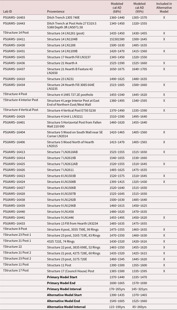
The primary model yielded a modeled start boundary for Piachi of between cal AD 1370 and 1435 (68% CI), a modeled end boundary of between cal AD 1600 and 1665 (68% CI), and a modeled overall interval (span) of between 170 and 265 years (Figure 3; Table 2). These start, end, and duration ages represent a much longer period of time than the traditional, previous age estimates of about 50 years max, with a primary occupation of about AD 1535–1570.
Kernel density estimate plot (Bronk Ramsey Reference Bronk Ramsey2017) for both the primary model (top) and the alternative model (bottom). Modeled start and end boundaries from both the primary and alternative models are also included. AD 1600 is indicated with a dashed line for reference. (Color online)

Figure 3 Long description
The image A showing a density plot with two overlaid filled distributions and two outline curves. The horizontal axis is labeled Modelled date (AD), ranging from 1200 to 1800 with labeled ticks at 1200, 1300, 1400, 1500, 1600, 1700 and 1800. The vertical axis has labeled ticks at 0, 0.05, 0.1 and 0.15. A vertical dashed line is drawn at 1600. The filled distributions rise from near 0 around 1200, increase through the 1300s and form a broad high region from about 1400 to the mid 1500s. The highest part of the upper outline curve is around the mid 1500s, slightly above the 0.15 tick. After 1600, both filled areas and outline curves decrease toward near 0 by about 1700. Below the distributions, there is a row of open circles spread mainly between about 1350 and 1650, with a few circles extending closer to 1700. Beneath the circles are two separate black, low, mound-shaped filled features: one centered around the 1400s and another centered around the late 1500s to early 1600s. The image B showing a density plot with two overlaid filled distributions and two outline curves. The horizontal axis is labeled Modelled date (AD), ranging from 1200 to 1800 with labeled ticks at 1200, 1300, 1400, 1500, 1600, 1700 and 1800. The vertical axis has labeled ticks at 0, 0.05, 0.1 and 0.15. A vertical dashed line is drawn at 1600. The filled distributions rise from near 0 around 1200, increase through the 1300s and show two main humps between about 1400 and the mid 1500s, with the taller hump in the mid 1500s reaching slightly above the 0.15 tick on the upper outline curve. After 1600, the distributions taper down toward near 0 by about 1700. Below the distributions, open circles are clustered mainly between about 1400 and 1600, with fewer circles extending beyond 1600. Beneath the circles are two separate black, low, mound-shaped filled features: one centered around the 1400s and another centered around the late 1500s to early 1600s.
Modeled AMS Dates from the Primary Model and Modeled Age Estimates for Boundaries from Both the Primary and Alternative Models.

Table 2 Long description
The table lists radiocarbon lab IDs and proveniences with modeled calendar-year ranges in AD for two uncertainty levels, plus whether each sample was used in an alternative model. Most modeled ranges fall between the mid 1300s and mid 1600s, with a few later results such as Structure 21 Hearth B around 1650 to 1675 at the narrower uncertainty level. Several Structure 4 and Structure 5 wood and post samples center on the late 1300s through 1500s, while many Structure 7 to Structure 9 samples extend into the 1500s and early 1600s. The primary model boundary estimates place the start around 1370 to 1440 and the end around 1600 to 1665, implying an overall duration on the order of roughly two to three centuries depending on uncertainty. The alternative model boundaries start around 1390 to 1435 and end around 1545 to 1605, indicating a generally shorter span and an earlier end than the primary model. Rows marked as priors are included to support wiggle-matching of individual wood or charcoal sequences, so those entries reflect modeled constraints rather than fully independent measurements. Blank cells in the alternative-model column indicate samples used only in the primary model, which can affect how the two sets of boundary estimates compare.
Note: Ages marked with an (†) are priors that were included in the primary model from D_Sequences used for wiggle-matching individual posts/charcoal/wood.
As discussed earlier, to account for the double intercepts associated with many of the dates related to Piachi’s later occupation, we extracted all modeled posterior probability distributions with a single peak as priors and included them in a new, alternative model, which represents a TPQ for Piachi’s depopulation. The alternative model produced a modeled start boundary of between AD 1380 and 1435 (68% CI), a modeled end boundary of between cal AD 1545 and 1605 (68% CI), and an interval (span) of between 115 and 210 years (Figure 3). Importantly, because dates associated with the latest occupations of the site were those most likely to be excluded due to their unresolvable double intercepts with the calibration curve (Figure 4), the end range of cal AD 1545–1605 represents a TPQ or the earliest possible depopulation range for Piachi.
Modeled posterior probability distributions exhibiting a single peak from the primary model that were included in the alternative model (top) and those exhibiting multiple peaks that were excluded from the alternative model (bottom). AD 1600 is indicated with a dashed line for reference. (Color online)

Figure 4 Long description
The first graph shows modeled posterior probability distributions over time. The x-axis is labeled ′Modeled date (AD)′ with ticks at 1300, 1400, 1500, 1600, 1700, 1800 and 1900. The y-axis is labeled ′Probability Density′ with ticks at 200, 400, 600 and 800. A thick line starts high around 1300, declines to a local peak near 1400, then drops to around 400 by 1500. It dips further to 300 between 1500 and 1600, rises to a hump near AD 1600, then sharply declines post-1600. Thin horizontal lines represent uncertainty intervals. The second graph is similar, with a thick line starting high around 1300, declining to a local peak near 1400 and dropping to around 400 by 1500. It dips to 300 between 1500 and 1600, rises slightly near AD 1600, then sharply declines post-1600. The hump magnitude and timing are similar in both graphs, with thin horizontal lines indicating uncertainty intervals. The dashed vertical line marks AD 1600 as a reference point.
Both models, when evaluated together qualitatively, reveal interesting facets of the town’s internal occupational chronology. The earliest modeled ages for the site come from samples excavated from the ditch surrounding the town (cal AD 1360–1440 and cal AD 1345–1450 [68% CI]) and from one of the dates associated with Structure 17, the public structure or council house located in the middle of the town (cal AD 1345–1450). Two households (Structures 4 and 8) yield dates that overlap with the fourteenth century, and Structures 5, 14, and 21 yield ages dating to the early 1400s. The order analyses described earlier support these chronological placements and indicate that the earliest dates (statistically) are those associated with these structures and features.
This pattern thus suggests that the founding of the town was associated with a formalized layout consisting of public infrastructure and an arrangement of houses that would come to define the community organization. It is likely that the town began fully formed and did not necessarily follow Hally’s (Reference Hally2008) model of a small founding population followed by gradual growth. The main difference, however, is that the absolute dates associated with this timeline are expanded to include a much longer range of time. At the very least, Piachi seemed to have been established at least 100 years earlier (or more) than traditional estimates would indicate.
The latter portion of the town’s occupation remains less clear. Previous estimates place depopulation at about 1570. Hally (Reference Hally2008) indicated that this was the end of the “formal” occupation but that five structures (Structures 14, 23, 25, 27, and 28) continued to be used beyond that time. As previously noted, the alternative model places the modeled end range for the town between cal AD 1545 and 1605; however, we argue that this is the absolute earliest end range, with known dates that extend beyond this range but that cannot be assigned to one of multiple peaks. We also find potential evidence for the addition of houses later in Piachi’s occupation. Structures 7, 13, and 24 all exhibit later dates associated with a post-AD 1520 arrival at the earliest, but possibly (likely) with postcontact, after AD 1540. Indeed, these structures yielded dates that statistically (based on the order analysis) had to come after the majority of dates from across the site. Interestingly, these houses are also some of the smallest domestic structures excavated and are situated spatially in places between, behind, or in front of existing earlier houses, potentially indicating a “filling in” as new households moved to the fortified town. In the next section, we place this new internal chronology into a regional context that helps refine and illuminate these interpretations.
Discussion: Piachi in Context
Southern Appalachia, AD 1000–1600: Shifting Sociopolitics
Although our newly estimated end ages for Piachi subtly push its occupation later in time, likely to a post-AD 1600 depopulation, our newly modeled start ages for the founding of the town diverge more substantively from traditional estimates. Whereas traditional estimates place its occupation beginning around 1535, our models place initial occupation between about cal AD 1370 and 1440, which is about 100–150 years before the currently cited dates. Even though more work is needed to estimate the beginning of the Coosa polity writ large, the traditionally used date of an integration occurring around AD 1400 tracks well with the newly modeled beginning range for Piachi’s occupation. Lulewicz (Reference Lulewicz2018) produced modeled estimates for 20 platform mounds across northern Georgia and eastern Tennessee, and the newly modeled start ranges for Piachi, cal AD 1370–1440, are consistent with the timing of the depopulation of most platform mounds across the region and the establishment and initial use of the platform mound at the Little Egypt site, about AD 1400 (Figure 5). The new dating of Piachi suggests that potentially this new form of settlement (small, compact towns without mounds) began to be practiced by northern Georgia communities almost immediately after the breakdown of the elite networks and mosaic political networks that characterized the region before emergence of the Coosa political network.
New temporal placement of the King site occupation compared to modeled chronologies for 20 mound sites from across southern Appalachia (adapted from Lulewicz Reference Lulewicz2018). (Color online)

Figure 5 Long description
The bar graph shows modeled age ranges for Southern Appalachia Mounds, with vertical bars representing each site. The horizontal axis is labeled Modeled Age cal AD, ranging from 1100 to 1685. The vertical axis lists mound sites. Two horizontal bands indicate King modeled periods: Start (cal AD 1370-1435) and End (cal AD 1605-1665). Sites are arranged from earliest to latest: Salt Creek, Shiloh, Stark Farm, Nifflers, Dyar, Moundville, Lamar, Leaning Rock, Hiwassee Island, Etowah, Funkhouser, Pine Mountain and Piachi Mound. Piachi Mound shows multiple intervals, indicating extended occupation. The King start range overlaps with the earlier sites, while the end range extends beyond most site occupations. The graph uses distinct colors to differentiate King periods and site ranges, enhancing visual clarity.
Importantly, it seems that the town of Piachi was formally organized at its founding (Figure 6). The central public/council houses, the ditch/palisade, and a number of houses in a formal arrangement around a plaza all date to virtually the same moment. The occupation at the town was not gradual. Nor is there evidence for a founding family or lineage, after which other families slowly trickled into the town. From the comparison of Piachi’s occupation to mound chronologies from across the region, the town’s founding seems to have been contextualized by a landscape in flux, in which mound building was slowing down, mound sites were being depopulated, and new forms of settlement were emerging across the region. All these transformations would have been the context for encounters with Spanish entradas about 100–150 years later (Blanton Reference Blanton2023; Cobb Reference Cobb2019). Simply put, Spanish conquistadors are not encountering a timeless landscape that reflected the kinds of “classic” “Mississippian” societies often cited by archaeologists. At the same time, the new temporal placement of Piachi places the town squarely in temporal association with these “Mississippian” mound sites, eroding the distinction between so-called Mississippian and proto-historic or contact period sites, towns, and peoples. Indeed, the first residents at Piachi would have been only one generation removed from these major mound centers like Etowah.
General timeline for the occupation of the King site. Chronological resolution and data availability (e.g., only one sample for some houses) do not currently allow a more detailed internal history to be resolved, but these broad temporal placements are supported by both the primary model and the order analysis. Green features—the ditch and council house (Structure 17)—yielded the earliest ages. Structures colored yellow are also early and overlap significantly with the early dates from the ditch and council house. Orange structures overlap with yellow and green features but do not yield dates as early as these others. Red structures only yielded dates from the latest end of King’s occupation. (Color online)

Figure 6 Long description
The map illustrates an archaeological site with labeled structures and features. A green boundary represents the ditch palisade encircling the site. The map includes a central post marked in black. Structures are numbered from 1 to 30, with color coding indicating different temporal phases: green for the earliest, yellow for early, orange for overlapping with earlier phases and red for the latest. The extent of excavations is outlined, showing the areas explored. A scale bar indicates 40 feet for reference. The map provides a spatial layout of the site, highlighting the arrangement of structures around the central post and within the ditch palisade.
Finally, the new chronological placement for Piachi’s depopulation challenges notions of immediate collapse or impact from encounters with Spanish entradas. We argue here that Piachi was depopulated sometime after AD 1600, at least 60 years after De Soto’s expedition and 40 years after Juan Pardo’s expedition. This is at least two more generations of occupation beyond contact with Spaniards. Taking into account the challenge of providing evidence for any Spanish massacre of Piachi’s residents, it is unlikely that encounters with Spanish entradas had immediate or substantive impacts on the daily lives of Piachi’s residents: certainly, they were not the proximate cause for its so-called collapse. This is consistent with other recent work at colonial-era sites across the region (Blanton Reference Blanton2023; Cobb et al. Reference Cobb, Blanton, Boudreaux, DePratter, Dumas, Knight, Legg, Lieb and Smith2024; Holland-Lulewicz et al. Reference Holland-Lulewicz, Thompson, Wettstaed and Williams2020)
That said, evidence for the potential addition of new families/households to Piachi’s population in its final decades poses important questions for understanding the wider impacts of both encounters with Spanish entradas and the fluctuations of Indigenous political institutions at the time (Figure 6). Why are new households filing into Piachi in its last few decades? Why are these houses smaller? Are they newcomers or familial expansions of existing households? What role did initial contact with Spanish entradas or disease outbreaks play in these demographic fluctuations happening at the turn of the century, around AD 1600? These questions remain unanswered.
Southern Appalachia after AD 1600: Population Movements and the Formation of the Creek Confederacy
The post-AD 1600 timing for Piachi’s depopulation has key implications for understanding the postcontact social and political landscape of Southern Appalachia (and beyond). Until now, the precise timing and structure of population movements across southern Appalachia and the Deep South in the sixteenth and seventeenth centuries have remained somewhat elusive. This is no fault of archaeologists and historians, because we have been constrained by the paucity of data and the inability of our tools to resolve these movements and chronologies at higher resolutions. Based on the ethnohistoric documentation, there are two sets of “knowns,” which Smith (Reference Smith1987) used to estimate population movements and their timings. The first chronological “knowns” are the historically recorded occupations of Indigenous towns across Southern Appalachia (like Piachi) encountered or written about by Spanish expeditions in the mid-sixteenth century. The second chronological “knowns” are the mid- to late seventeenth-century occupations of the Upper and Lower Creek towns of Alabama and Georgia (presumably the destinations of Ancestral Muskogean towns and peoples moving from the east into what are historically documented Creek towns). For our case in particular, although the exact timing of the settlement of the Upper Creek towns is not completely resolved, the available consensus indicates that these towns, located in east-central Alabama, were occupied at the very latest by the 1680s, not only by local populations but also by those moving into the area from the east—from other Ancestral Muskogean towns across what is today Georgia.
One of the main drivers often cited for the movement of populations from northwestern Georgia westward into Alabama is the collapse of the ethnohistorically documented Coosa polity, into which Piachi was supposed to have been integrated. It is estimated that the polity, or the network of allied towns constituting the political entity, began to disintegrate from the late sixteenth century into the earliest years of the seventeenth century. With a TPQ for depopulation of cal AD 1545–1605, Piachi’s participation in these regional processes likely extended into the early decades of the seventeenth century. Recent work at the Hightower site, located in east-central Alabama, revealed the emergence of so-called coalescent communities across the region at least by AD 1630 (Nelson Reference Nelson2020). Embedded within a landscape of towns with homogeneous ceramic assemblages, the Hightower site is one example of a new kind of town exhibiting extreme ceramic heterogeneity compared to local styles and technologies. Indeed, substantive proportions of the Hightower assemblage are styles that are traditional to the communities of northwestern Georgia, including Piachi (Nelson Reference Nelson2020). The newly estimated timing of the depopulation of Piachi, post-AD 1600, thus articulates well with broader processes as revealed cross-regionally.
The added longevity of northwestern Georgia, or Coosa, towns compared to traditional estimates is not surprising and is consistent with other studies demonstrating the endurance of Indigenous institutions well into the seventeenth century after initial encounters with Spanish colonizers (Holland-Lulewicz et al. Reference Holland-Lulewicz, Thompson, Wettstaed and Williams2020). Our new dating of Piachi contributes not only to these ongoing efforts to track Indigenous–colonizer dynamics, populations movements, and both short and long-term impacts of these interactions but also to understanding the development of the sociopolitical institutions that were eventually encountered by Spanish colonizers at contact, as well as the development of the Creek Confederacy that is ancestral to the political institutions of the modern Muscogee Nation.
Conclusion: Relinking Histories
Piachi’s newly modeled temporal position is key to linking often disparately considered time periods—or so-called cultures—and regions. Analytically, distinctions are often made between classic Mississippian towns and institutions, contact period sites, and Creek towns. This has created false historical disconnects between the Mississippian, contact, and historic (Creek) peoples and time periods, as well as modern descendant communities, specifically the Muscogee Nation. All these distinctions represent the same people, yet archaeologists have continued to parse them into unique units of analysis. The dating project we undertook for one single town goes a long way in empirically “relinking” these traditional periods and thus enabling a better understanding of the historicity of broad regional and temporal processes, including population movements and colonialism as a process writ large. Piachi, as a single case study, forms a link between the classic Mississippian towns of Southern Appalachia (like Etowah) and the historically known Creek towns and even the Creek Confederacy, providing an empirical basis on which to dissolve the arbitrary boundaries imposed on Indigenous histories.
Like other studies in the region—and even those more broadly across eastern North America—have demonstrated, colonization was not a single event that happened at a single time and had a single, totalizing impact on Indigenous societies and institutions. The residents of the town at Piachi experienced direct interactions with Spanish colonizers, potential violent encounters with De Soto’s men, epidemics, and all the indirect opportunities for destabilization caused by these encounters. Yet, the narrative of a swift and immediate demise following these entanglements continues to be chipped away at and empirically challenged by archaeological research, especially chronological work.
Critically, however, it is not archaeological work alone, or even primarily, that is effectively eroding these narratives. Indeed, such new insights are not in fact “new” at all for Indigenous descendant communities, including that of the Muscogee Nation; the placement of archaeological research within Indigenous / community-informed goals and frameworks is key to efforts to illuminate and (re)impose continuity. As discussed elsewhere for the authors’ work across this region (e.g., Holland-Lulewicz Reference Holland-Lulewicz2025; Holland-Lulewicz et al. Reference Holland-Lulewicz, Thompson, Wettstaed and Williams2020; Thompson et al. Reference Thompson, Holland-Lulewicz, Butler, Hunt, Wendt, Wettstaed, Williams, Jefferies and Fish2022; Thompson, Birch, et al. Reference Thompson, Birch, Butler, Cherkinsky, Garland, Golya, Hadden, Hunt and Williams2026; Thompson, Williams, et al. Reference Thompson, Williams, Golya, Garland, Broadbent, Schroder and Sampson2026), (re)linking deep ancestral pasts remains a core component of the efforts of Tribal Nations, including agencies like the Historic and Cultural Preservation Office or the Office of the Secretary of Culture and Humanities of the Muscogee Nation; our conversations over the years with these agencies have strongly guided the contours and motivations of the present work.
Finally, we can only continue to resolve the critical processes that took place across the sixteenth and seventeenth centuries if we move toward synthetic work that brings together the many new chronologies, timelines, and age ranges being produced by teams of archaeologists across broad regions. The new chronology for Piachi is only valuable because we are able to articulate it with other recent chronological efforts across the region. Without these broader articulations, we are only creating islands with very little of the context necessary to illuminate the important processes we seek to understand as anthropologists, archaeologists, and historians. Further, Piachi’s new chronological position between the eleventh- and fourteenth-century Mississippian chiefdoms on the one hand, and the seventeenth-century emergence of the Creek Confederacy on the other, is one that archaeologists have only recently been able to resolve. In fact, in resolving the vagaries associated with this portion of the calibration curve, Piachi’s position contributes to an unbroken, empirically situated historical continuity between the modern-day Muscogee Nation and time immemorial across Ancestral Muskogean homelands.
Acknowledgements
Thanks to the Muscogee (Creek) Nation Historic and Cultural Preservation Office and the Office of the Secretary of Culture and Humanities, especially Secretary RaeLynn Butler, for our valuable discussions and consultations. Thanks to the University of Georgia Laboratory of Archaeology and its director Amanda Roberts Thompson for facilitating access to the collections used in this work. Finally, thanks to the many individuals who have contributed through meaningful and substantive discussions about the work presented here, including Jennifer Birch, Victor Thompson, Stefan Brannan, and David Hally.
Funding Statement
Funding was provided by the Wenner-Gren Foundation for the award, “The Temporality of the Post-Contact Landscape: A Microhistory of a Sixteenth-Century Ancestral Muskogean Town.”
Data Availability Statement
All data used in this study are included in the tables; OxCal code used to build Bayesian models is included as Supplemental Material 1. OxCal code and all priors are also archived on Zenodo (https://zenodo.org/records/18865879).
Competing Interests
The authors have none.
Supplementary Material
The supplementary material for this article can be found at https://doi.org/10.1017/aaq.2026.10225.
Supplementary Material 1. OxCal Code for Reproducing Primary and Alternative Models and Results Presented in the Article.




 Open access

