
 ΠΑΥΛΟΥ,
 [ται ἐν αὐτῇ.
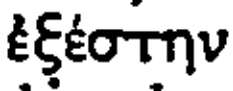 . cf. Septuagint, Habakkuk III, 2. An abbreviated quotation characterizes Habakkuk in the church of the Theotokos Pammakaristos, Constantinople; cf. van Millingen, op. cit. (note 83), Pl. 41. Width of scroll 0·16 m., length 0·40 m.; height of figure c. 1·50 m.

Crossref Citations

This article has been cited by the following publications. This list is generated based on data provided by Crossref.
Trombley, Frank R.
1985.
Paganism in the Greek World at the End of Antiquity: The Case of Rural Anatolia and Greece.
Harvard Theological Review,
Vol. 78,
Issue. 3-4,
p.
327.
Sheppard, Anne
2001.
The Cambridge Ancient History.
p.
835.
Hall, Stuart George
2001.
The Cambridge Ancient History.
p.
731.
Cameron, Averil
Ward-Perkins, Bryan
and
Whitby, Michael
2001.
The Cambridge Ancient History.
Allen, Pauline
2001.
The Cambridge Ancient History.
p.
811.
Cormack, Robin
2001.
The Cambridge Ancient History.
p.
884.
Brown, Peter
2001.
The Cambridge Ancient History.
p.
781.
Browning, Robert
2001.
The Cambridge Ancient History.
p.
855.
Mango, Marlia Mundell
2001.
The Cambridge Ancient History.
p.
918.
Roueché, Charlotte
2001.
The Cambridge Ancient History.
p.
570.
Rousseau, Philip
2001.
The Cambridge Ancient History.
p.
745.
Özdaş, Harun
and
Kızıldağ, Nilhan
2013.
Archaeological and Geophysical Investigation of Submerged Coastal Structures in Kekova, Southern Coast of Turkey.
Geoarchaeology,
Vol. 28,
Issue. 5,
p.
504.
Sweetman, Rebecca
2015.
THE CHRISTIANISATION OF THE PELOPONNESE: THE CASE FOR STRATEGIC CHANGE.
The Annual of the British School at Athens,
Vol. 110,
Issue. ,
p.
285.
2016.
2017.
2017.
Kızıldağ, Nilhan
2019.
Late Holocene sea level change along the coast of Fethiye Gulf in southwestern Turkey.
Geoarchaeology,
Vol. 34,
Issue. 3,
p.
295.
Terpoy, Kristina
2019.
Questioning Late Antique prosperity: the case of Lycia (southwest Turkey).
Byzantine and Modern Greek Studies,
Vol. 43,
Issue. 1,
p.
1.
Tekin Bellibaş, Nevin Esin
and
Tanyeli, Gülsün
2020.
Cultural Significance Assessment for the Archaeological Heritage of the Lycian Region.
Conservation and Management of Archaeological Sites,
Vol. 22,
Issue. 3-6,
p.
117.
BİLİR, Güzin
2020.
ANITSAL YAPILARDAKİ MEZAR ANLAYIŞI: HEROONDAN MARTYRİUMA.
Uludağ Üniversitesi Fen-Edebiyat Fakültesi Sosyal Bilimler Dergisi,
Vol. 21,
Issue. 39,
p.
607.