NORTH OF THE ANTONINE WALL
PERTH & KINROSS
(1) Arlary (NO 14 05): a copper-alloy gilded plate brooch with conical black glass setting,Footnote 10 of late second-/early third-century date, was recovered by metal-detectingFootnote 11 in the vicinity of an Iron Age souterrain.Footnote 12 This is an unusual type for Scotland.
FIFE
(1) Dumbarnie (NO 45 03): an unusual copper-alloy openwork enamelled ‘raquet-headed’ plate broochFootnote 13 was found by metal-detecting in an area with extensive later prehistoric settlement remains.Footnote 14
FALKIRK
(1) Easter Carmuirs, Primary School (NS 8598 8058): magnetometry surveyFootnote 15 and excavation have revised the sequence of known camps. Previous work identified multiple ditches;Footnote 16 the 2019 excavations found a corner to the northern ditch, forming the south-western corner of a camp. Its western side is marked by a much shallower ditch and a parallel slot on the exterior. The ditch to its south must relate to a separate camp. Magnetometry survey revealed anomalies consistent with bread ovens, focused on the ditch edges and presumably using them for shelter or to save labour in construction.Footnote 17 This suggests a third, larger camp is present in the area.Footnote 18
THE ANTONINE WALL
FALKIRK
(1) Falkirk, Williamson Street (NS 88994 79770): excavation in advance of developmentFootnote 19 revealed a stretch of metalled roadway, 1.8 m wide, utilising an older hollow way.Footnote 20 It was cut by a short, sinuous ditch containing amphora sherds, and a Roman date for the road seems assured. It lies some 80 m north of the Antonine Wall, running north-west–south-east, near-parallel to it. In this position, on the western side of the East Burn, it is likely to lead to the nearby hypocausted building immediately south of the Wall where it crosses the burn at Kemper Avenue.Footnote 21
(2) Mumrills, (a) fort (NS 919 794): finds from a programme of fieldwalking and metal-detectingFootnote 22 include a denarius of Domitian (of a.d. 90) and a copper-alloy figurine of a bound captive,Footnote 23 the first known from Scotland.
ParaInd(b) 34 Polmont Road, Laurieston (NS 9162 7940): further work on the southern side of the annexe, east of the current house, revealed Roman timber buildings, housing ovens or furnaces, and an east–west road.Footnote 24
(3) Bo'ness, 47 Dean Road (NT 0000 8106): an evaluation trenchFootnote 25 located what must be the northern edge of the Wall ditch, on the Ordnance Survey line. This is the most easterly point where the line has been confirmed.
SOUTH OF THE ANTONINE WALL
MIDLOTHIAN
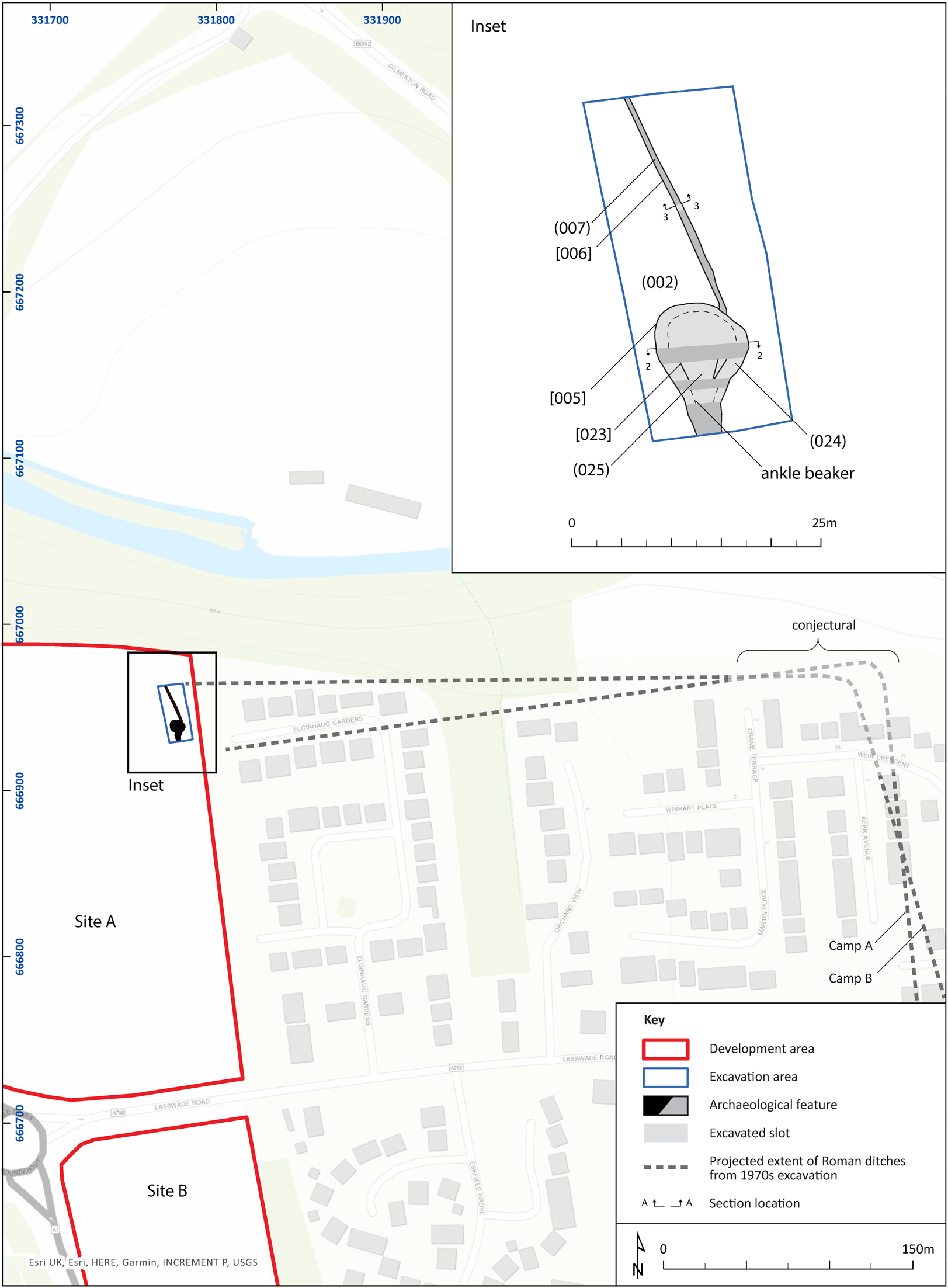
(1) Eskbank, Lasswade Road (NT 31785 66753): evaluationFootnote 26 of an area on the western edge of the temporary camp complexFootnote 27 revealed a stretch of an irregularly V-sectioned ditch (3.5 m wide, 1.3 m deep) with basal slot, likely to be from one of the camps (fig. 1). It expanded into an unusual flat-based rounded terminal (9 m across, 3 m deep); a narrow slot ran northwards from this.Footnote 28 The terminal had been deliberately backfilled after some natural infill had accumulated; a shallow V-sectioned penannular ditch was later cut into it. The arrangement suggests a gateway, but the greatly expanded terminal and the location (very close to a projected corner and the river edge) would be unusual, unless there has been dramatic river erosion.Footnote 29
Eskbank: ditch in relation to known and projected cropmarks of temporary camps; the blue band to the north is the river Esk. (Courtesy of AOC Archaeology)

SCOTTISH BORDERS
(1) Torwoodlee (NT 46 38): metal-detecting in the environs of the hillfort and broch, the latter known from excavation to be rich in Roman imports,Footnote 30 recovered a trumpet brooch and an enamelled plate brooch of stepped-lozenge form.Footnote 31
DUMFRIES & GALLOWAY
(1) Kirtlebridge (NY 23 73): a hoard of 43 denarii, ending with Hadrian.Footnote 32
SUPPLEMENTARY MATERIAL
For supplementary material for this article please visit https://doi.org/10.1017/S0068113X20000392