NOTTINGHAMSHIRE
(1) Worksop, Gateford North (SK 5767 8232): a watching-brief, evaluation and excavation recorded two parallel trackway ditches which terminated at a small group of enclosures. The earliest activity was a field-system of late Iron Age or early Roman date that was remodelled during the first to second centuries with the addition of a trackway leading to a pair of sub-square enclosures. One of these enclosures contained a post-built structure dating to the mid-first to second century, as well as pits and a probable corn-drier. The remains were maintained and remodelled through the second to fourth centuries.Footnote 128
DERBYSHIRE
(1) Barlborough: 6 silver denarii: one each of Republic (M•BAEBI•Q•F, 137 b.c.), Mark Antony (32–1 b.c.), Domitian (a.d. 81–96), Trajan (a.d. 98–117) and Hadrian (a.d. 117–38; PP on obv. a.d. 128). Date of deposition c. a.d. 128.Footnote 129
STAFFORDSHIRE
(1) Barlaston I: hoard of 1 AE denarius and 2,014 radiates. Denarius: Gallienus (sole reign) (a.d. 260–8), 1. Radiates extend from joint reign of Valerian and Gallienus (a.d. 253–60) to Probus (a.d. 276–82; last coin of Bastien series 2, a.d. 276). Found in the remains of a Roman globular urn composed of a finely sorted greyware fabric. Date of deposition c. a.d. 276.Footnote 130
(2) Eccleshall: hoard of 25 radiates, extending from Gallienus (sole reign) (a.d. 260–8) to Probus (a.d. 276–82). Date of deposition c. a.d. 281.Footnote 131
(3) Fradley and Streethay I and II: 10 silver denarii to a.d. 4 from 2016 T9: 8 of the Republic and 2 of Augustus (31 b.c.–a.d. 14). 2 silver denarii to a.d. 124 from 2016 T2, 1 each of the Republic and Hadrian (a.d. 117–38). As 2016 T9 forms a recognisable early denarius hoard, the two cases were treated as separate deposits; it is possible, however, that the Republican denarius of 2016 T2 is properly part of 2016 T9 and the (equally fragmentary) coin of Hadrian found at the same time is a stray. Date of deposition c. a.d. 4 (a.d. 124?).Footnote 132
(4) Hopwas area: hoard of 14 silver denarii: 1 each of Vespasian (a.d. 69–79), Domitian Caesar and Divus Vespasian under Titus (a.d. 79–81); 4 each of Trajan (a.d. 98–117) and Hadrian (a.d. 117–38); 2 of Antoninus Pius (a.d. 138–61) and 1 of Diva Faustina I. Latest closely dated coin of Pius = TR P XV = a.d. 151/2, but the Diva Faustina I type potentially brings the deposition date up to the end of the reign (a.d. 161).Footnote 133
(5) Lapley: 2 fragmentary silver siliquae, both uncertain emperor of the house of Valentinian, a.d. 364–78 (VRBS ROMA, Roma seated left on throne). Date of deposition c. a.d. 378.Footnote 134
SHROPSHIRE
(1) Telford, Humber Lane (SJ 70000 15150): an archaeological evaluation targeting geophysical anomalies uncovered the remains of a probable Romano-British field-system. Seven ditches were excavated only three of which produced small quantities of datable artefacts of probable second- to third-century date.Footnote 135
(2) Staggs Brook, Whitchurch (SJ 5405 4184): an archaeological watching-brief was conducted during the reinstatement of a culvert. The groundwork comprised the excavation of a pipeline trench, 140 m long and 1.5 m wide, a replacement for a likely nineteenth-century culvert carrying the flow of Staggs Brook, a tributary of the river Elf.Footnote 136 The site is situated close to the present day St Alkmund's church, the former site of Roman fort — Mediolanum — established c. a.d. 70. The site lies within the civilian settlement (vicus), which was established to the south and north of the fort, either side of Watling Street. Prior desk-based assessment had suggested the presence of a vicus and an adjacent extramural cemetery.Footnote 137
The easternmost extent of the trench cut into the sloping bank of the hill, exposing successive deposits of colluvium capped with a post-medieval/modern soil horizon; the lower layers of colluvium contained moderate numbers of pottery sherds and tile, broadly dated to the first and second centuries. The lowest stratigraphic layer comprised a stiff natural clay, overlain by alluvial deposits of sand, waterlogged peat and clay. The remains of a revetment structure, comprising an upright beam, horizontal land-tie and overlapping tangentially faced planks, were exposed at 2.5 m; further remains of a plank structure were recorded 70 m to the west. A sample was taken of the land-tie to verify the tree species, thought to be oak, and to establish a date through dendrochronology. In addition, a large quantity of worked wood was retrieved from waterlogged deposits in discrete areas across the site.
One section of the pipeline was found to truncate bands of waterlogged peat and clay, sealing an in-filled palaeochannel. A large and important assemblage of artefacts was recovered from the channel, with a date range spanning the first and second centuries. This area also yielded tentative structural evidence in the form of a wooden plank, post and upright and recumbent lengths of coppiced wood, sealed within the channel. Taken together the assemblage resembles the remains of a collapsed structure, possibly a dismantled building or more likely, a river crossing. Both interpretations can be supported by the intensity of artefacts, either lost or cast into the channel.
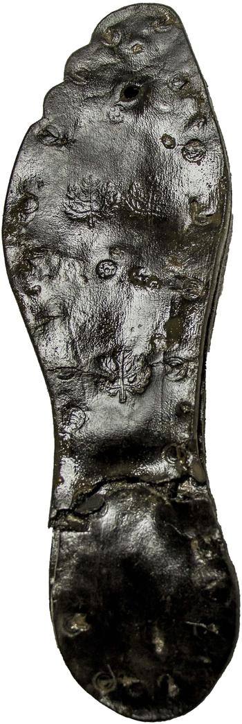
The western portion of the site had been subject to considerable modern activity; at depth, beneath the modern deposits, lay a compact spread of rubble and ceramic building material and pottery of Roman date. In total, 885 fragments of Roman pottery were recovered during the course of the work, the pottery assemblage being dominated by finewares of both local and imported types, including amphora, implying that the site benefited from the military trading routes. Other ceramic material included fragments of tegula. Two metal items were retrieved: a copper-alloy military-type button-fastener with red and blue radial enamelling and a socketed hammer complete with wooden handle. The most impressive artefacts included 171 leather offcuts, 7 whole shoes, 16 additional soles, 20 miscellaneous items and a leather bag. It is noteworthy that a considerable proportion of the soles and the leather bag bore the same tanner's mark, an impressed olive-branch motif (fig. 25). This motif does not correspond with any other maker's marks of this type found in Britain.
Sole of leather sandal exhibiting tanner's mark from Staggs Brook, Whitchurch. (© Salford Archaeology)

As a result of the watching-brief it has been possible to confirm Roman activity within the site area.Footnote 138 Remnants of a timber revetment, exposed in two areas of the trench, point towards an intense use of the Staggs Brook watercourse in antiquity. Given that the excavation targeted the existing culvert at the base of river valley, the land either side has been left undisturbed. It is expected that remains of settlement are more likely located to the south and north of the pipeline, an area adjacent to the identified palaeochannel. While direct evidence of settlement is lacking, the retrieval of a large quantity of leather items and offcuts provides good evidence of tanning and leather-working. A nearby military presence is also suggested by the variation and high status of the ceramic finds, military-type fastening and Roman footwear, which were found in particular abundance in proximity to a collapsed structure or river crossing.
WORCESTERSHIRE
(1) Cookley: 4 silver/base silver denarii: including 1 each of Hadrian (a.d. 117–38), Antoninus Pius (a.d. 138–61) and Septimius Severus (Wars of Succession) (a.d. 193–8). Date of deposition c. a.d. 198.Footnote 139
(2) Elmley Lovett: 6 silver denarii: 4 of the Republic (minted between 115 and 62 b.c.) and 1 each of Augustus (31 b.c.–a.d. 14) and Tiberius (a.d. 14–37). Date of deposition c. a.d. 37 or later.Footnote 140
(3) Evesham, Avon Business Park (SP 03350 41660): evaluation trial-trenching investigated a co-axial network of ditches associated with a scheduled Romano-British roadside settlement, located immediately to the south of the site. An inhumation grave of probable Roman date was also recorded and left in situ. Romano-British material, with a date range of second to later fourth century, dominated the finds assemblage. Building material, including the base of a finely carved stone column, was recovered, though no structural remains were found in situ. The environmental and animal bone evidence indicates a mixed farming economy.Footnote 141
WARWICKSHIRE
(1) Alcester, land north of Arden Forest Industrial Estate (SP 0902 5872): an evaluation uncovered a Roman ditched enclosure visible on aerial photographs and a broadly contemporary field-system containing first- to second-century pottery. Previously, the enclosure had been interpreted as a marching camp, but evidence from the evaluation, including its location on low-lying ground, an absence of gateways, the paucity of finds and the ditch profiles, suggests that the enclosure was more probably agricultural.Footnote 142
(2) Hampton Lucy, land west of Snitterfield Street (SP 2544 5760): archaeological evaluation carried out as part of a consideration for a residential development recorded a series of ditches, pits and irregular-shaped features, with the ditches forming part of a field-system. Based on the pottery recovered the features are dated to the second century, with one ditch dating from the first to second century. In addition to the pottery a second-century copper-alloy Roman brooch was recovered from one of the ditches. As part of the evaluation a geophysical survey was carried out, which also noted several linear anomalies which shared the same alignment as the excavated ditches.Footnote 143
(3) Stratford-upon-Avon: (a) Arden Heath Farm (SP 2233 5489): evaluation found three broadly parallel ditches, aligned north–south, and a number of tree-throws sharing the same alignment. The westernmost ditch contained a single sherd of Severn Valley ware, which suggests the ditch was in use from the second century. All the other features were undated. The ditches appeared to be on a similar alignment to a Roman road recorded in the Warwickshire HER and seen on the geophysical survey carried out in the area in 2013. However, the shallow depth and homogeneous fills of the ditches indicate that the features uncovered in this excavation relate to a trackway forming part of a wider field-system on a similar alignment to the Roman road, but are not characteristic of Roman roadside features themselves.Footnote 144
(b) Dunstall Field, Tiddington Road, Phase 2 evaluation (SP 2145 5555): evaluation took place following a desk-based report and geophysical survey. The majority of the trenches in the middle part of the field proved to be blank, confirming the negative evidence of the geophysical survey, except for Trench 17 on the east, which contained early Roman (shallow) features comprising four ditches (one recut) and a pit. Another field boundary ditch was also found in Trench 14. No further Iron Age features were found in the vicinity of the pit found in the Phase 1 excavation of Trench 7, indicating that this was an isolated example.
In the eastern trench (Trench 11) the dark horizons contained Roman pottery and overlay a Roman ditch or gully cut into the sandy clay at the base of the hollow. A shallow ditch indicated by the geophysical survey was also found; this cut one dark layer and was sealed by further inwash deposits. In the middle trench (Trench 12) the dark fills were similar and also included Roman finds. To the west, the deposit containing Beaker evidence was not found, but the overlying dark fills were investigated and also proved to be Roman. Overall a concentration of Roman activity was confirmed in the east and south-east of the field, crossing the hollow, with field boundaries to the north and west of this.Footnote 145
(4) Warmington II: hoard of 440 silver denarii in a small Roman whiteware flagon, including 172 of the Republic, 37 of Augustus (31 b.c.–a.d. 14), 23 of Tiberius (a.d. 14–37), 1 of Caligula (a.d. 37–41), 5 of Claudius (a.d. 41–54), 8 of Nero (a.d. 54–68), 49 of the Civil Wars (a.d. 68–9), 9 of Galba (a.d. 68–9), 10 of Vitellius (a.d. 69) and 2 of Vespasian (a.d. 69–79); the rest of uncertain emperor, illegible or irregular. Of the two Vespasian types, one is illegible while the other is the Judaea type of a.d. 70–1. Date of deposition c. a.d. 71.Footnote 146
LEICESTERSHIRE
(1) Burton on the Wolds: hoard of 1 radiate and 25 Constantinian nummi. Radiate: Victorinus (a.d. 269–71) (irregular). Nummi ranged from a.d. 313–18 to 335–40. Date of deposition c. a.d. 340.Footnote 147
(2) Charley: 4 silver denarii, 2 of the Republic and 1 each of Julius Caesar (minted 47–46 b.c.) and Mark Antony (minted 32–1 b.c.). Date of deposition c. 31 b.c. or later.Footnote 148
(3) Donisthorpe, land at Talbot Place (SK 3126 1356): geophysical survey in response to a planning application for a residential development revealed a complex of linear and curvilinear features representing a continuation of the known Romano-British enclosure system previously recorded to the west of the site.Footnote 149
(4) Enderby, Leicester Lane South (SP 554 998): archaeological evaluation in response to a proposed planning application for mixed commercial and residential development revealed evidence for archaeological activity of late prehistoric and Roman date. Romano-British activity of first- to second-century date in the form of hearths, ditches, gullies and pits was identified close to the known course of the Fosse Way Roman road and possibly linked to the road by a trackway. One of the Roman ditches contained a dump of stone rubble and box-flue tile that may have been deposited during the third century and indicates later activity in the area. Gravel spreads identified in trenches adjacent to the postulated course of the Fosse Way may represent traces of eroded metalling from the road while ditches running parallel to the road were also recorded.Footnote 150
(5) Hallaton Roman villa (SP 7880 9800): excavation on the site of a possible Roman villa located to the north of Hallaton village (HER Ref. MLE1634), followed fieldwalking undertaken in the 1970s and geophysical survey of the area in 2000. Three trenches were excavated, one through the centre of what was thought to be the interior of the villa and a large pit to the west (Trench 1), and two across ditches outside the structure (Trenches 2 and 3). Trench 1 contained several robber trenches and a make-up layer for a floor, suggesting that it formed the interior of a room. A number of large tiles including one still in situ indicated a hypocaust system, while a burnt stone structure in the corner may have been part of the associated furnace. Foundations of a stone wall and areas of cobbling to the east could possibly have been part of a courtyard. The pottery from within the area was dated predominantly between the second and fourth centuries, indicating a mid- to late Roman occupation date. South of the excavated room, the ground sloped downwards to a large pit (identified by geophysical survey) which turned out to be a substantial pond, with a number of drainage channels running downslope into it. Trenches 2 and 3 both found ditches corresponding to the geophysical survey results. These lay on the same orientation as the villa, contained similar pottery types, and may represent field-systems associated with the structure.Footnote 151
(6) Houghton on the Hill, Ingarsby Lane (SK 467885 304469): archaeological field evaluation was carried out in advance of the development of the site for a solar farm and related infrastructure. A previous phase of geophysical survey had located potential archaeological anomalies, although the majority of the results appeared to relate to medieval or post-medieval ridge-and-furrow ploughing, field boundaries and modern underground services. The evaluation consisted of 16 trenches excavated across the proposed development area and positive results were revealed in five. Archaeological features included gullies and ditches, along with a single inhumation burial, all of which were associated with pottery sherds indicating a mid- to late Iron Age to early Roman date for the activity.Footnote 152
(7) Ibstock, land at Station Road (SK 4008 1000): a 15-trench trial evaluation prior to proposed residential development sought to investigate features identified in previous geophysical survey results. Archaeological features were largely limited to the southern and western parts of the development area and comprised linear ditches, broadly dated to the Iron Age/Roman period, and further undated features.Footnote 153
(8) Kibworth Harcourt, land north of Fleckney Road (SP 67304 93919): a 16-trench trial evaluation found ditches, gullies, large pits and a possible trackway that were tentatively dated to the Roman period.Footnote 154
(9) Leicester, St Nicholas Circle (SK 58226 04453): trial-trench evaluation carried out in response to new development proposals relating to the Jewry Wall Museum, initially comprising six trenches, each 2.5 m2, that were cut through the footpath along the southern boundary of the Jewry Wall bath complex. Archaeological evidence was located in all six trenches and consisted of Roman, medieval and post-medieval deposits. A second phase of evaluation was subsequently undertaken at the revised location for a proposed ramp, on the south-eastern side of the Roman bath complex. A Roman wall was located in two trenches, as well as an opus signinum floor, together with numerous Roman artefacts. These could relate to the baths complex, or else be evidence for a separate building adjacent to it.Footnote 155
(10) Lockington, East Midlands Gateway (SK 46500 27000): an evaluation comprising 160 trial-trenches and 205 test-pits defined the limits of Iron Age and Romano-British remains previously identified in an evaluation undertaken in 2014. Late Iron Age and Romano-British boundary ditches were recorded in several locations. A modest Romano-British artefactual assemblage probably spanning the second to fourth centuries was recovered, including a hairpin with bead-and-reel mouldings and an illegible coin. Environmental samples were dominated by the remains of spelt wheat; probable remains of rye were also identified, along with evidence of malting.Footnote 156
(11) Lutterworth: (a) land east of Leicester Road (SP 5474 8602): an archaeological strip, plan and record excavation was undertaken prior to the proposed development of the site. Two open-area excavations targeted concentrations of archaeology identified during an earlier trial-trench evaluation by Allen Archaeology in 2014. In Area 1 six ditches of Roman date and a single Roman pit were identified, alongside several undated ditches. No Roman archaeology was found in Area 2.Footnote 157
(b) Magna Park (SP 504 847): excavation comprising six small areas totalling c. 1.5 ha was undertaken, in advance of the possible expansion of Magna Park, revealing evidence of early to middle Iron Age and Roman activity. Roman remains were primarily located to the west and adjacent to the A5 (which follows the course of Roman Watling Street), where a series of ditches, pits and post-holes was investigated. This area of activity extended beyond the limits of the development area and, therefore, its full extent and character remain uncertain.Footnote 158
(c) Swinford Road (SP 54870 83880): following geophysical survey which had provided clear evidence for archaeological activity across the southern and western part of the area, trial-trench evaluation was targeted to specifically investigate the survey results and to establish the presence/absence of remains across the northern part of the site. Some 19 trenches were excavated, confirming the presence of a large, single-phase, rectangular enclosure measuring c. 112 m by 70 m, occupying the former high ground across the southern part of the site. Pottery assemblages recovered from its ditch securely date it to the late second century. Some ferrous metal-working activity (smithing) was also undertaken at the site as evidenced by hammerscale and burnt clay fragments recorded in Trench 3.Footnote 159
(12) Market Harborough: (a) Manor Farm (SP 719 876): extensive open-area excavation and additional evaluation trenching was undertaken in advance of residential development. An early Roman farmstead, which occupied the same location as an unenclosed Iron Age settlement, was investigated. The settlement was more extensive than its Iron Age predecessor and extended over 2.6 ha. It comprised a rectilinear system of ditched enclosures, some of which showed evidence of recutting. No later Roman artefacts were found and it is presumed that this settlement was abandoned by the mid-third century. Fragments of 12 brooches (of types known to be in use in the first century) were recovered, but only one possible coin was found. Perhaps the most significant metal find is a military sword-scabbard chape dated to a.d. 100–200.Footnote 160
(b) Overstone Park, Kettering Road (SP 7476 8639): trial-trench evaluation was undertaken prior to residential development. The site comprised agricultural land and extended to some 38 ha. Two principal late Iron Age–early Roman enclosures were recorded in the northern part of site, while a lesser enclosure was located between the two. The enclosures or settlement areas were broadly contemporary but varied in character, particularly in terms of the associated pottery assemblages. The archaeology appears to be directly related to similarly dated evidence recorded to the immediate west, an interpretation supported by the results of geophysical survey.Footnote 161
(13) Melton Mowbray, New Guadaloupe, Leicester Road (SK 741 180): following geophysical survey, a field evaluation was carried out in response to development proposals for housing. At the southern end of the development an extensive area of Roman occupation of third- and fourth-century date was revealed. The trenches targeted rectangular geophysical anomalies and revealed numerous features, including ditches, post-holes and possible beam-slots.Footnote 162
(14) Syston, land on the Fosse Way (SK 6208 1244, SK 6210 1251): a watching-brief carried out during work to replace two culverts identified a possible agger and two possible roadside ditches of unknown date.Footnote 163
(15) Waltham on the Wolds, Hall Farm, Mere Road (SK 8053 2532): following geophysical survey and a trial-trench evaluation, a strip, map and sample excavation was undertaken in advance of residential development. The archaeology proved to be predominantly of the late Iron Age to early Roman period, with part of a large enclosure and a ring gully on the eastern edge of the site. Industrial waste, in the form of fuel ash, hearth lining and heated limestone blocks, was found within these features and the surrounding pits. Accompanying the industrial activity, the pits revealed evidence of farming, while several shallow parallel gullies projecting from the large enclosure may represent part of a contemporary field-system. The evidence indicates that the site is on the fringes of a small rural settlement or farmstead, which appears to be mostly located beneath Mere Road and the field to the east.Footnote 164
(16) Wymondham, Spring Lane (SK 849 187): an initial four-trench evaluation in advance of the construction of an all-weather horse exercise arena was immediately followed, due to the quantity and quality of the archaeology, by an archaeological excavation of the entire arena area. Earlier work by the University of Nottingham, which took place on land to the north of the proposed arena between 2002 and 2004, revealed evidence of a third- or fourth-century Roman villa or farmstead.Footnote 165 The 2016 excavation revealed in-situ foundations of property boundary walls, demolition layers, linear features and pits. The results probably represent peripheral activity associated with the previously investigated villa or farmstead. Dating evidence indicates landuse ranging from the late first century through to the early fourth. The presence of a substantial stone wall of probable third- or early fourth-century date suggests a major rebuilding and redevelopment of the villa estate at this time.Footnote 166
NORTHAMPTONSHIRE
(1) Burton Latimer: (a) Cranford Business Park (SP 9008 7592): archaeological excavations were carried out adjacent to the A14. In addition to Bronze Age and Iron Age archaeology a large area of early Roman activity was identified, which included several ditched enclosures probably related to agriculture. One part of the site contained several Roman corn-driers, along with stone-lined tanks and several wells. Archaeobotanical evidence suggests that this area was used for brewing.Footnote 167
(b) East Kettering Balancing Pond (SP 9001 7719): archaeological excavations carried out in advance of the construction of balancing ponds and associated infrastructure as part of the wider East Kettering development revealed extensive Roman remains, including a large area dedicated to crop-processing. This included stone- and clay-lined tanks, along with two corn-driers. Charred plant remains from this area include germinated spelt, along with notable quantities of sprouts from germinated grains indicative of large-scale brewing on the site.Footnote 168
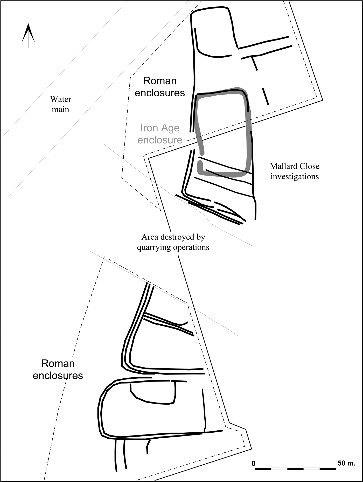
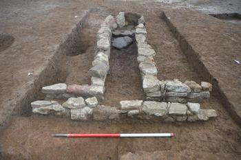
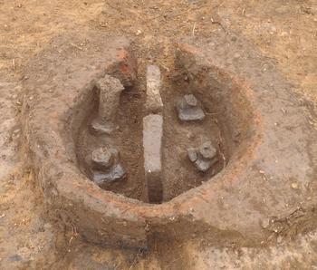
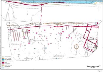
(2) Earls Barton, land adjacent to Mallard Close (SP 853 647): open-area excavation took place in advance of residential development in an area of known archaeological activity. This revealed a settlement which originated as a single, sub-rectangular, middle Iron Age enclosure and continued in use until the mid-first century, when it was encompassed within a more complex system of enclosures (fig. 26). The Roman settlement continued to be occupied until the end of the fourth century. It probably covered c. 3 ha (including those parts beyond the development area) and comprised a series of adjacent sub-rectangular enclosures; given their form in plan, they can be described as a ‘ladder’ system. Two Roman drying ovens were found, while a third is known from the 2001 investigations. They were all of the common, T-shaped form (fig. 27). The sides of one were mainly of limestone, while the other was dug into the ironstone bedrock and, therefore, did not need to be lined.Footnote 169
Earls Barton, Northants.: site plan. Scale 1:3,000. (© Albion Archaeology)

Earls Barton, Northants.: drying oven. (© Albion Archaeology)

(3) Harworth: a forger's hoard of 26 radiates, 243 denarii and at least 27 uncertain denarii/radiates in fragmentary condition. Denarii: 123 of Elagabalus (a.d. 218–22) and 120 of Severus Alexander (a.d. 223–5). Radiates: 2 of Gordian III (a.d. 238–44) and 24 of Decius (a.d. 249–51). A preliminary analysis of the hoard suggests that the bulk of the coins are irregular, with hybrid types combining obverses and reverses not usually associated with one another. Furthermore, while all of the coins demonstrate some corrosion products due to their deposition and current state of preservation, many appear to have possible base metal content with flaking surfaces on some examples suggesting they are of irregular production and possibly plated. Further conservation work is required to clarify the nature of their manufacture. All were found together as a group in a ditch fill (context 808), but with no identifiable burial context (e.g. a container or vessel) surviving in the archaeological features. Date of deposition c. a.d. 251.Footnote 170
(4) Irchester, Chester Farm (SP 91893 66848): two Roman stone-lined wells were excavated as part of a larger excavation undertaken by volunteers for Northamptonshire County Council. The first measured 0.7 m wide and 3.75 m deep and contained seven fills. Abundant amounts of pottery and animal bone were recovered from all fills, including four complete vessels. The lower waterlogged deposits contained the remnants of preserved wooden sticks and twigs, along with other environmental remains. The second well measured 0.7 m wide and 3.35 m deep, with five fills. Vast quantities of animal bone were recovered from the fills, with generally low levels of pottery. A small number of metalwork finds were also recovered, including a bronze needle. As with the first well, the waterlogged deposits contained a large amount of preserved wooden sticks and twigs. The basal fill also contained part of what appears to be a wooden bucket.Footnote 171
(5) Northampton, Dallington Grange (SP 7268 6331): evaluation trenches targeted the periphery and selected features within a known Iron Age settlement and successfully confirmed the presence of the features identified by the cropmark and geophysical survey plots. A combination of large enclosures and slighter ditch boundaries was recorded along with occasional pits and a single juvenile cremation that contained at least two individuals. Dating evidence was relatively sparse but spanned the Iron Age into the early Roman period. The features appeared to be well preserved while good assemblages of charred plant remains were present within several of the features.Footnote 172
(6) Norwell: 7 Constantinian nummi, ranging from a.d. 313–18 to 330–5. 7 late fourth-century nummi/nummi fragments were also found. None were legible but their condition and smaller module suggest they were primarily later strays. Date of deposition c. a.d. 335.Footnote 173
(7) Towcester, proposed Baptist Church, Northampton Road (SP 6934 4928): excavations revealed a small unenclosed occupation site dating from the middle Iron Age overlain by elements of a probable Roman field-system.Footnote 174
(8) Yelvertoft, DIRFT III, land east of Watling Street (SP 5648 7540): an excavation identified the remains of a Roman agricultural landscape consisting of trackways, field boundary ditches and groups of pits, tree-throw holes and waterholes. A cremation burial may also have been of Roman date.Footnote 175
CAMBRIDGESHIRE
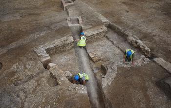
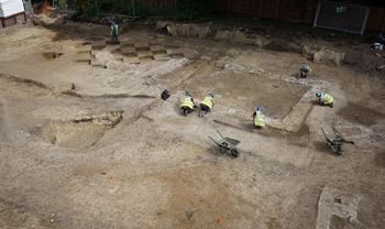
(1) Bottisham, Crystal Park, Tunbridge Lane (TL 54514 60917): following trial-trench evaluation in 2014, a 0.5 ha open-area excavation revealed the remains of three Roman buildings with stone (including clunch and Barnack limestone) and tegula wall footings, which formed part of a villa range and detached bath-house (figs 28 and 29). Concentrations of box-flue tile indicate the presence of a hypocaust in at least parts of the villa range. Two of the buildings extended beyond the excavation area and probably adjoined structural remains found in previous excavations to the north. Previous large-scale excavations at several sites in this part of the village over the last 20 years have found remains of the farmyards, outbuildings and infield areas of the villa estate. In contrast, large parts of this site in the vicinity of the Roman buildings were fairly empty of contemporary features, although evidence could have been destroyed by ground levelling undertaken during World War 2. If this absence of features is genuine, however, this part of the villa complex may have been used as gardens or a courtyard. Pottery and other finds suggest that the main period of occupation was during the later third and fourth centuries.Footnote 176
Crystal Park, Bottisham: excavation of detached building, possibly a bath-house, although there are structural ambiguities which render this interpretation tentative. (Photo: Miles Venni; © PCA)

Crystal Park, Bottisham: excavation of part of the villa complex. (Photo: Miles Venni; © PCA)

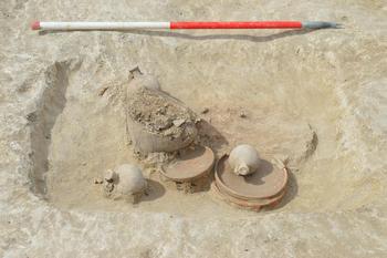
(2) Brampton, Zone B, RAF Brampton (TL 2087 7007): following on from evaluation work in 2015 excavation discovered eight early Roman pottery kilns clustered in the south-east corner of the site (fig. 30). The kilns were very well preserved and contained in-situ pedestals alongside clay plates, spacers and large quantities of Roman pottery, including wasters. These kilns are thought to date to c. a.d. 60–80 and were largely producing lid-seated greyware globular jars and lids. These kilns provide an insight into early Roman pottery production in this part of Cambridgeshire, adding to a growing corpus of broadly contemporary kiln sites in the county, such as those at Swavesey, Duxford, Greenhouse Farm and the Addenbrooke's Hutchison Site. Other features dating to the Roman period included a small number of pits, ditches and gullies.Footnote 177
Brampton, Cambs.: early Roman pottery kiln. (© OA East)

(3) Cambridge: (a) Hatherdene Close, Cherry Hinton (TL 4841 5761): excavation was undertaken following on from evaluation in 2007. A number of Roman inhumation and cremation burials were uncovered, along with associated enclosures. The cremations were notable for their fine late Roman accessory vessels which were sourced from Central Gaul, the Lower Nene Valley and Trier in Germany (fig. 31).Footnote 178
Cherry Hinton, Cambs.: late Roman cremation burial. (© OA East)

(b) Land south of Dame Mary Archer Way, Addenbrookes (TL 4617 5458): a 0.93 ha open-area excavation was undertaken on land directly south of previous excavations by OA East (Papworth) and CAU (AstraZeneca) which revealed a significant prehistoric to Roman landscape. The continuation of early Roman field-systems extending from the north was found, along with a small sub-rectangular enclosure interpreted as either a hayrick or a structure used as a seasonal shelter.Footnote 179
(4) Eaton Socon, land at 21–35 Great North Road (TL 1691 5809): excavation recorded part of a probable third-century field-system. Finds were sparse, indicating that, at this time, the site was agricultural land some distance away from settlement areas. In the fourth century, the field-system was superseded by a set of curvilinear enclosures which, in contrast to the earlier period, contained large assemblages of animal bone, pottery and other finds. The presence of some later fourth-century vessel forms, together with part of an Anglo-Saxon decorated rounded jar, recovered from one of the Roman ditches, suggests that occupation continued into the fifth century. A watering hole contained preserved wood and a fragmentary leather shoe, associated with coins of Tetricus I (a.d. 270–3) and a fourth-century nummus.Footnote 180
(5) Ellington, land west of Brook Farm, Thrapston Road (TL 1550 7210): geophysical and aerial photographic survey followed by a trial-trench evaluation found a set of mid- to late Roman ditches aligned approximately ESE–WNW, the two largest of which probably formed a trackway. The trackway ditches had evidence of having been recut, suggesting some degree of longevity.Footnote 181
(6) Ely, land north of Cam Drive (TL 54375 81748): 0.8 ha of land was excavated, revealing a Romano-British field-system and part of a contemporary settlement. The latter included a large segmented ring-ditch, from which an assemblage of late Iron Age to early Roman pottery was recovered. Overlying part of the settlement was a large spread of midden material that contained mid- to late Roman pottery including Nene Valley wares. Also recovered from the spread were two early Roman coins and large fragments of quernstone.Footnote 182
(7) Godmanchester, land at Corpus Christi Lane (TL 24431 76229): trial-trench evaluation of c. 1 ha of land located 100 m outside the west gate of Roman Durovigutum and 50 m from the Roman road to Sandy recorded a dense complex of settlement-related features, including boundary and drainage ditches, soil layers and areas of intercutting pits. Associated finds included large quantities of first- to mid-third-century pottery, animal bone, oyster shell, ceramic building material and slag, indicating a focus of light industrial activity including iron-smithing and butchery.Footnote 183
(8) Littleport, 16 Station Road (TL 5706 8691): a small evaluation revealed evidence for Roman salt production, including an assemblage of briquetage, a possible in-situ structure and patches of burning, all located c. 1.5 m below modern ground level. The associated Romano-British pottery assemblage includes some imported wares, suggesting that activity on this potentially large saltern was taking place during the late second and early third centuries.Footnote 184
(9) Multi-parish, A14 Cambridge to Huntingdon Improvements (TL 1920 7453–TL 3891 6388): a trenched evaluation on ten plots of arable farmland, as part of the early works programme on the A14 Cambridge to Huntingdon Improvement Scheme, primarily targeted cropmarks and geophysical survey results. The northern end of this work was located at Matcham's Bridge, in the parish of Alconbury, while the eastern end lay to the north of Bar Hill, in the parish of Oakington and Westwick. Evidence for Roman occupation was widespread on the gravels of the northern section of the scheme and coincided with areas of Iron Age activity, suggesting continuity of settlement in places. The main focus of activity was found across Plot 31, where trenching revealed an extensive network of ditched boundaries and scattered pits spanning the first to fourth centuries. The results of aerial photographic and geophysical surveys indicate that these belong to a palimpsest of ditched sub-rectangular enclosures on at least two separate alignments. Boundaries of a possible field-system to the north of this settlement complex were found in the adjacent field of Plot 24. Further south, another series of small Roman curvilinear and rectilinear enclosures was found along the eastern edge of Plot 73. These date to the first to second centuries and contained sherds of residual Iron Age pottery suggesting they may have later prehistoric origins. The adjacent field of Plot 76, Hilton, contained poorly dated ditches, some of which yielded Roman pottery, and a scatter of discrete pits and post-holes. The ditches largely correspond to the linear features shown on the aerial photographic survey and it is suggested that they belong to a field-system extending out from a cropmark settlement complex located to the south of the plot. Other potential Roman field boundaries were found at Plot 1, located immediately north of another major cropmark complex.Footnote 185
(10) The Stukeleys: (a) Alconbury IKO Site (TL 1980 7730): ten evaluation trenches and a small excavation area were opened, near the western end of Alconbury Airfield. A single late Iron Age roundhouse gully, associated pits and enclosure ditches were excavated. While the pottery is almost exclusively of pre-Roman date, a stamped Roman sherd of probable late first-century date may have originated from the London and Staines area. A carved and polished bone hand-guard from a first-century military sword was also found, which has parallels ranging from Avenches in Switzerland to Masada in Israel.Footnote 186
(b) Alconbury Weald (TL 200720 764350): excavations were undertaken on land just to the north-west of Ermine Street. Two main phases of activity spanning the Iron Age and Roman periods were identified which include an area of settlement and associated field-system in the north-western corner of the site. The southern edge of the site revealed a Roman rectangular enclosure, while a watering hole or pond with associated ditches running into it may have formed part of a drainage system.Footnote 187
(c) Alconbury Weald KP1 (TL 19839 76486): a small evaluation uncovered a single Roman pit, possibly related to an adjacent ditch.Footnote 188
(d) Alconbury Weald Mechanical Plant Training Facility (TL 2161 7624): two areas of evaluation were undertaken, on land to the north of Ermine Street. The first area identified a Roman boundary ditch that is likely to have demarcated activity to the east of the development area. The second revealed more concentrated activity, including several ditches dating to the Roman period, probably part of a field-system.Footnote 189
(e) Alconbury Weald Parcel 4 (TL 1990 7640): two excavation areas were opened on land just to the north-west of Ermine Street. These uncovered late Iron Age and Roman features, with the former probably relating to the transitional phase between the two periods. The majority of features were found at the western end of Area 2, where they related to the settlement activity found during previous excavations, and in Area 1 where there was a separate enclosure. Between the two areas there were a limited number of archaeological features that were probably related to the field-system and animal husbandry on the periphery of the settlement.Footnote 190
(11) Waterbeach: (a) land at Bannold Road (TL 5020 6598): a small excavation was undertaken for the purposes of investigating the wider context of various Roman pits identified during an earlier evaluation and interpreted as early Roman (first–second century) small-scale clay extraction for pottery production.Footnote 191 The excavation revealed further pits confined to an area of natural clay geology with no evidence of associated settlement. Limited finds included small quantities of animal bone and abraded pottery sherds. The lack of associated settlement evidence suggests that the pits were related to clay extraction associated with the Horningsea pottery industry, potentially for use at kilns recently excavated at 12 Pieces Lane or elsewhere in the vicinity.Footnote 192
(b) Waterbeach Barracks and Airfield (TL 4901 6700): a large evaluation was undertaken in the area of the former airfield, primarily targeting historical aerial photographic and geophysical survey results. Evidence for activity dating to the Roman period was widespread, with three areas containing dense concentrations of Roman remains. The latter includes ditches of primarily mid- to late Roman origin belonging to a network of enclosures, a pottery kiln, at least two areas of inhumation burials, field-systems, cultivation furrows, marl quarries, finds-rich pits, ditched boundaries and an undated post-built structure.Footnote 193
(12) Wimpole, Wimpole Hall car park (TL 3401 5060): evaluation on land to the south of Wimpole Hall revealed a well-defined enclosed farmstead dating from the Iron Age to the early Roman period. This activity was concentrated on the high ground in the north-western part of the development area and included enclosure ditches, pits and possible structural remains. Other notable features included a cobbled surface, roundhouse ring-gullies and the remnants of an oven. Contemporary pottery was recovered.Footnote 194
PETERBOROUGH
(1) Peterborough, land at Paston Reserve (TF 1979 0298): evaluation identified a concentration of Roman features at the topographically highest point of the site, c. 130 m south of Car Dyke, an artificial water channel constructed during the first century. The archaeological features consisted of concentrations of small pits and post-holes and at least three phases of boundary ditch, aligned north–south. Almost all the features produced assemblages of ceramic building material and predominantly late second- to fourth-century Roman pottery, indicating the presence of a Roman settlement in the near vicinity.Footnote 195
BEDFORDSHIRE
(1) Bedford: (a) land north of Biddenham (TL 025 505): construction of a new school revealed part of a Roman farmstead which included a ditched enclosure system that covered 0.4 ha and extended beyond the development area. Other than ditches, the commonest features were pits, many of which were probably dug to quarry clay. The finds assemblage included mainly second- to third-century pottery (5 kg) with a few late Roman sherds, Roman brick and tile, fired clay, animal bone (6 kg) and metal artefacts (including a brooch, seven coins and two buckles/spurs).Footnote 196
(b) Manton Lane (TL 0414 5099): the fourth season of a community project was undertaken in an area of known Roman settlement.Footnote 197 A single trench revealed a Roman levelling terrace, dug into the hillside, where only the stone footings and lowest stone course partially survived from the corner of a heavily robbed building. The ground within the building was c. 0.5 m below the Roman surface level and comprised firm clay, scorched in places, laid on a foundation raft of large stones. A single sub-square area of mortar within the sub-floor is suggestive of the base of a pilae tile stack. The north wall had collapsed outwards and survived relatively intact with at least 12 courses visible; the larger stones at the eastern end probably represent the corner of the building. Elsewhere on the terrace traces of other buildings were identified in the form of stone pads and floor make-up deposits. Other features included two ovens or hearths and a steep-sided trench, which may have been associated with drainage or water supply. Ceramic roof and combed flue-tiles, painted wall-plaster, window-glass and stucco were recovered, suggesting a building of some status.Footnote 198
(2) Biggleswade, Stratton Farm and Newspring Farm (TL 21146 40987): a total of five areas were excavated across a proposed pipeline route. They revealed large ditches, pits, beam-slots, a cobbled surface and a cremation, the majority of which date to the late Iron Age and early Roman periods. Large quantities of pottery were recovered, alongside animal bone and fired clay.Footnote 199
(3) Moggerhanger, land adjacent to The Guinea Public House (TL 141 493): open-area excavation on a 0.6 ha residential site revealed a settlement occupied from the early–middle Iron Age through to the late Roman period, with a general pattern of settlement shift from north to south. Roman activity was concentrated largely in the area directly adjacent to the A603 at the south end of the site and comprised rectangular enclosures, a possible roundhouse, pits and post-holes. Artefacts included an intact ‘toilet set’, a silver coin and a number of copper-alloy coins dating from the first to the fourth centuries.Footnote 200
HERTFORDSHIRE
(1) Ashwell, land west of No. 1 Claybush Road (TL 26780 39253): evaluation revealed two small features, a ditch and a pit, dating to the Roman period alongside prehistoric and post-medieval remains.Footnote 201
(2) Buntingford, land north of Park Farm Industrial Estate (TL 35600 30400): excavation of c. 3 ha of land on the west side of Roman Ermine Street identified an earlier prehistoric routeway on the same alignment and other contemporary activity. Evidence from the Roman period consisted of five cremation burials and a line of Roman quarry pits beside the road, which were dug to extract natural gravel for use in its construction or repair.Footnote 202
(3) Little Hadham, A120 Bypass and Flood Alleviation Scheme (TL 4428 2326): an evaluation identified a probable Roman enclosure ditch and latrine pit. The finds assemblage, which included first- to second-century pottery, is suggestive of settlement. A droveway within the site may have joined the route of the Stanegate at Hadham Hall to the south.Footnote 203
BUCKINGHAMSHIRE
(1) Aylesbury, Broughton Crossing (SP 8360 2145): a strip, map and sample excavation and watching-brief revealed multi-period activity. While occupation may have been continuous from the late Iron Age through to the Saxon period, the main focus of activity was concentrated from the late first to late second centuries, when over 50 ditched field boundaries were in use. Artefactual material was focused along the northern part of the site, suggesting a higher concentration of activity in that area.Footnote 204
(2) Dinton, Springhill Stud, Cuddington Road (SP 7578 1157): an archaeological evaluation and excavation was carried out prior to the erection of farm out-buildings. Features dated from the Iron Age or early Roman period and consisted of large pits, possible quarry pits and plough soil. Activity continued into the second century, when an enclosure ditch was in use. There was minimal later activity prior to the early modern period.Footnote 205
(3) Whaddon: hoard of c. 162 AE radiates, ranging from Gallienus (sole reign) (a.d. 260–8) to Tetricus I (a.d. 271–4). Date of deposition c. a.d. 274.Footnote 206
OXFORDSHIRE
(1) Abingdon, Old Gaol (SU 4979 9694 (site 1); SU 4979 9689 (site 2)): two sites previously excavated at the Old Gaol in 2010 suggested that the site was part of an urban Roman landscape; recent reconsideration of the site has led to its reinterpretation as the location of a Roman religious complex.
Around a.d. 60–70, a square building (temple) was constructed on a slope over earlier features. Later, in c. a.d. 150, it was demolished and relocated slightly to the south. The new structure was probably c. 11 m square, although this cannot be categorically confirmed as the south wall of the structure lay outside the area of excavation. During the Roman period it is apparent that a number of gravel surfaces were laid, probably some seven in all, which accumulated to a depth of 0.7 m deep. Possibly due to this persistent resurfacing the stone structure was rebuilt again, sometime between a.d. 250 and 330. A significant associated find is a small statuette of a water bird, examined by Martin Henig at Oxford University, who identified it as a possible goose of probable second-century date and, as such, the earliest representation of a water bird with an S-shaped neck in the British Isles.Footnote 207
(2) Appleford, Bridge Farm Quarry (SU 5220 9380): a c. 4.6 ha area in the southern part of Hanson's Sutton Courtenay gravel quarry was excavated, revealing features and deposits ranging from at least the early Bronze Age to post-medieval in date (fig. 32). There was no meaningful evidence for Roman activity earlier than the second century. This activity was concentrated at the eastern margin of the site where a group of rectilinear ditched enclosures was aligned NNE–SSW, apparently fronting onto the west side of a ditched trackway on the same alignment, known from aerial photographs and limited excavation in the 1970s. The maximum WNW–ESE dimension of the enclosures within the excavated area was c. 65 m and it is estimated that the trackway probably lay immediately east of the site, giving a maximum depth of perhaps 75–80 m. There was little evidence for Roman features within the enclosures; pits and post-holes within the main south-westernmost enclosure, for example, were almost entirely undated and are likely to have been of post-Roman date, but three pits lying close to or on the line of the boundaries of this enclosure may have been contemporary with it. A stone-lined well, c. 2.1 m deep, lay within the enclosure to the north and was filled in the late Roman period. The latest fills of the enclosure ditches were mostly of late Roman date, in some cases after a.d. 350. Towards the north end of the complex its ditches were cut by a single boundary ditch, aligned east–west, which ran the entire length of the site, some 343 m, and continued beyond it in both directions. This feature, up to c 2.2 m wide and 0.8 m deep, lay 7–16 m south of a later prehistoric boundary and seems to have effectively reinstated the same boundary, probably very late in the Roman period.
Appleford, Bridge Farm Quarry: multi-period activity in the southern field. Scale 1:1,000. (© OA South)

Part of the area west of the enclosure complex was used for burials, which occurred in two main groups with further scattered burials elsewhere. The principal group contained at least 16 inhumation graves and one cremation burial. Fourteen of these graves were aligned north–south (including one south–north burial), with two west–east. A second group, to the south-west, contained 12 inhumation graves, aligned north–south, and four more burials extended this alignment into the south-west corner of the site. Broadly late Roman dating is indicated by the alignments, the presence of coffin nails in some graves and the occurrence of single pottery vessels in three graves. Two pairs of extended inhumation burials on a predominantly west–east alignment, one in the northern part of the site, the other at the southern margin, were less certainly of Roman date.Footnote 208
(3) Benson, land off St Helen's Avenue (SU 618 912): previous geophysical survey had indicated a large curvilinear enclosure, a series of rectangular enclosures, a small curvilinear enclosure and a scatter of large and smaller pits. The evaluation comprised 22 trenches, targeting both geophysical anomalies and potentially blank areas, and represented a 2 per cent sample of the site.
Most of the excavated features were of early Roman date, with a focus of middle Roman activity on the east and late Roman activity on the south. Early Roman pits and ditches included fineware pottery suggesting that the site was of higher status that most rural settlements of the same date in Oxfordshire. Preservation of environmental charred plant remains was particularly good and indicated a zone of crop-processing in the north-east of the settlement. A chalk foundation and a possible circular well were found, together with box-flue tile fragments, roofing tiles and stone slates, suggesting that a masonry building existed close by, if not within the site itself.Footnote 209
(4) Bicester: (a) land at Bicester Gateway (SP 5731 2114): an evaluation identified two ditches containing first- to second-century pottery. These were overlain by a substantial ground layer which raised the level above the seasonal floodplain of the river Ray prior to the construction of a road in the mid-second century. Evidence for an associated roadside settlement dating to the late second–third centuries included floor surfaces and a possible corn-drier or kiln.Footnote 210
(b) Graven Hill (SP 5886 2083): a watching-brief and five evaluation trenches were undertaken during the removal of the ground slab following the demolition of Rodney House. Three shallow linear features were recorded in Trench 60 during the evaluation phase, one of which produced a single sherd of Roman pottery, but the remains did not provide conclusive evidence for the extent or character of activity within this field. The evaluation did find the remains of Roman Akeman Street within Trenches 62 and 63. The sequence recorded within these was comparable to those of Trenches 49, 58 and 59 from the 2015 evaluation with a surface constructed of limestone pieces set within a shallow terrace into the slope of Graven Hill. A single sherd of Roman pottery was recovered from the surface in Trench 63.Footnote 211
(5) Checkendon I: 2 gold Iron Age British staters, 5 silver Iron Age continental units and 1 Roman silver denarius. Gold: British A; uninscribed stater, type uncertain. Silver: drachm ‘au style Languedocien’; probable ‘au style Languedocien’; 2 drachmae, probably central west Gaul; silver unit, fragment, attributed to the Aulerci Cenomani, northern Gaul/Armorican. Denarius: Domitian Caesar under Vespasian (a.d. 69–79; struck a.d. 76, COS IIII). Date of deposition c. a.d. 76.Footnote 212
(6) Checkendon II: hoard of 24 AE sestertii and fractions (dupondius or as where noted), extending from Trajan (a.d. 98–117) to Faustina II under Marcus Aurelius (a.d. 161–80; d. a.d. 176). Date of deposition c. a.d. 176.Footnote 213
(7) Didcot, Great Western Park phase 2 (SU 5065 8953): following earlier work completed between 2010 and 2012, a major programme of excavation was undertaken in advance of housing development. Significant prehistoric archaeology was discovered, overlain by two enclosures in the early Roman period. In addition, contemporary linear ditches related to a field-system and associated trackways were found covering the majority of the site. Three Roman corn-drying ovens with associated pits and hollows were also discovered in close proximity to one another. Two are the more usual T-shape, whereas the third had a square central chamber. These can be added to the six corn-driers discovered during the first phase of the work, and might be related to a villa known at the site.Footnote 214
(8) Dorchester-on-Thames: (a) allotments (centred at SU 577 941): the training excavation begun by the Dorchester Project team in 2008 continued in the same 30 by 20 m area as in previous years, with the main north–south Roman road through the settlement at its eastern margin. In the western part of the site early Roman features included short lengths of irregular curving gullies, small pits and two parallel gullies, aligned north–south, one of which cut an infant burial. Not all of these features were well dated, but one of the curving gullies produced a reasonable group of late Iron Age/early Roman pottery and another produced a copper-alloy coin of Cunobelinus, while a further possible late Iron Age coin came from an adjacent deposit. These early features were overlain by a deposit of clayey loam up to c. 0.25–0.30 m thick, probably of later first-century date.
In the central part of the site a (previously identified) large oval pit (8 by 6 m), which occupied the southern part of the area, was shown to be vertically sided, with an estimated depth of 1.5 m. Its original function is uncertain, but its use for rubbish disposal from the second century onwards is clear. Immediately east of this area, traces of a possible foundation for a cob-built structure were located, which comprised the north-west corner of a fairly narrow L-shaped foundation filled with gravelly material, upon which was the remnant of a reddish clay deposit. Adjacent red clay to the east may have derived from the decay of walls of this nature, while a couple of metres further east again a sloping layer of banded gritty clay may represent part of another collapsed cob wall. A north–south linear feature to the east may represent a possible roadside wall, also of cob. All these elements can be broadly grouped in the second century.
Further work on the road demonstrated considerable local variation in the character of surface materials and the deposits accumulating between them. Towards the south-east corner of the site a well-paved surface, perhaps a pathway, running roughly east–west across the line of the road between its uppermost and second major surfaces, suggests discontinuity in the use of the north–south road, at least for a time. In the extreme north-east corner of the site a very late Roman steep-sided feature, possibly a palisade aligned east–west, was confirmed as cutting the line of the north–south road. The date of this feature remains unclear, although a terminus post quem of c. a.d. 400 seems fairly certain, but whether the feature should be assigned to the fifth century or rather later is yet to be resolved.Footnote 215
(b) 8 Malthouse Lane (SU 5771 9425): an archaeological evaluation consisting of two trenches was conducted as part of the planning process for an extension to the existing building. Trench 1 contained an occupation layer and remains of a wall foundation dating to the fourth century. Trench 2 contained three layers and one pit. The two lower layers were related to fourth-century Roman occupation and the upper layer was identical with the upper layer in Trench 1. The finds show intensive Roman occupation of the site up to the late fourth century.Footnote 216
(c) White Hart Hotel (SU 5780 9430): an archaeological evaluation comprising a single trench, 17 m long, identified two features possibly representing walls that had been robbed of stone. One corresponds closely with the conjectured alignment of the northern defences of the Roman small town.Footnote 217
(9) Drayton, land at Abingdon Road (SU 4478 1950): evaluation and excavation revealed a late Iron Age/early Roman enclosed farmstead and associated land boundaries. The pastoral farmstead was occupied between the mid-first and mid-second centuries. It was situated on a gravel island within the wider floodplain of the river Ock and included a reused Bronze Age drainage ditch.Footnote 218
(10) East Hendred, Portway Cottages, Reading Road (SU 4616 8937): evaluation trenches revealed archaeological deposits of early Roman date, which are thought to indicate the presence of a small farmstead.Footnote 219
(11) Eynsham: (a) Beech Court Care Home, Newland Street (SP 4350 0959): a watching-brief on groundwork, which consisted of demolition, extension and new build, revealed a series of features and deposits; the first phase of activity comprised several linear ditches of mid-Roman date.Footnote 220
(b) The Shrubbery, 26 High Street (SP 4344 0922): an archaeological watching-brief on foundation trenches for a new property and an attached terrace, a soakaway trench and two service trenches recorded three archaeological features: one Roman ditch and one undated ditch and a pit in the foundation trench. The service trenches cut through previously disturbed ground.Footnote 221
(12) Furze Platt, Blenheim Palace (SP 431 184): an archaeological evaluation was undertaken prior to the submission of a planning application in an area of former farm buildings proposed for redevelopment. The Park is a Grade I Registered Park and Garden, most of which has been designated as a World Heritage Site (WHS). The evaluation comprised two trenches targeted on landscape features identified during the previous walkover survey. Trench 1 was positioned across the projected line of the Roman road known as Akeman Street which runs east–west across the site. A second trench was located set back from the road to the south to look for any associated features. The aim was to establish the presence and state of preservation of the road within the boundaries of the present farm.
The evaluation confirmed that the Roman road survived between the farmhouse and the animal feed building, while the cracks observed in the north-east corner of the animal feed building show where it is subsiding into the northern roadside ditch. The road was found to be in a good state of preservation, with two layers of stony material deliberately deposited and forming a notable agger. The associated roadside drainage ditch was also located on the southern side.Footnote 222
(13) Harwell: (a) Kilnwood, Blenheim Hill (SU 4958 8938): following an evaluation, excavation on a site just across the road found further remains of later Roman date, including four main ditches forming two enclosures. Several pits and post-holes are likely to be contemporary.Footnote 223
(b) Land at Blenheim Hill (SU 4960 8910): trenching revealed a dense complex of features of Roman and probably mainly late Roman date. Follow-up excavation revealed that they formed a series of enclosures and land divisions, along with pits, a corn-drier and a coin hoard, with one early Roman and three late/latest Roman episodes. A few sherds of Saxon pottery hint that the last phase continued into the fifth century. Two deposits of cremated human bone (three individuals) are undated but might belong to the early Roman period.Footnote 224
(c) Land off Orchard Way (SU 4880 8915): an archaeological evaluation consisting of two machine-dug trenches each 30 m long was conducted as part of a planning application to develop an area for residential use. Within both trenches a major boundary/drainage ditch was recorded containing Roman pottery. Trench 1 also contained a small pit of Roman date, in addition to several undated features (rectilinear ditch, gully and a second ditch) within both trenches. Trench 2 contained two possible furrows that appear to relate to the ridge-and-furrow field-system within the area.Footnote 225
(14) Harwell: hoard of 115 copper-alloy Roman (mostly ‘barbarous’) nummi and one plated siliqua. Nummi extend from Constantine (a.d. 330–5) to Valentinian (a.d. 364–78). It may originally have been interred within a pottery vessel; however, on discovery this was fragmented and slightly scattered throughout the context. Date of deposition c. a.d. 378.Footnote 226
(15) Longcot, Shrivenham Road (SU 2724 9071): evaluation trenching in 2014 had revealed features of predominantly Roman date, including a substantial ditch and possible paved trackway or path alongside smaller gullies, isolated pits and post-holes. The subsequent excavation of a small area (750 m2) within the site revealed a dense sequence of field boundary ditches spanning several phases in the early Roman (second century) and medieval periods (eleventh–thirteenth centuries), with a few other features (pits and post-holes) of both periods. Prehistoric and later Roman activity is reflected only in residual finds. Although no direct evidence of occupation was found for either period, the quantity of pottery indicates that settlement can be expected not far away. This is the first indication of Roman occupation in Longcot.Footnote 227
(16) Long Wittenham, Didcot Road (SU 5468 9367): evaluation exposed a sequence of ditches of probable Roman date, which, with a pit and a cluster of post-holes, were generally sealed by a buried soil layer of possible alluvial origin. Three Anglo-Saxon cremation burials dating to the fifth or sixth century were cut into the buried soil, and along with a single inhumation burial, appear to be part of a larger cemetery located to the west of Didcot Road, excavated in the Victorian era. A bank associated with the ditches of Roman date may have formed the eastern boundary of the cemetery.Footnote 228
(17) North Moreton: hoard of 2 silver siliquae, 1 base metal radiate and more than 100 (mainly fused) nummi. Siliquae extend from Julian Augustus (a.d. 360–3) to Valentinian I (a.d. 364–75). Radiate: Divus Claudius II (barbarous). Nummi range from Constantius II (a.d. 337–61) to uncertain House of Valentinian. Date of deposition c. a.d. 383.Footnote 229
(18) Oxford: (a) Barton Park (SP 5450 0830): two trenches extending over 1.22 ha were targeted over archaeological features indicated during an earlier evaluation. They revealed the remains of sequential Romano-British field-systems, including rectilinear fields and possible droveways, representing several successive modifications to agricultural regimes, perhaps indicative of attempts to cultivate an area of poor and frequently waterlogged land. An isolated probable Roman cremation burial was found among these agricultural features. The pottery assemblage from the whole site was limited, comprising little more than 60 or so sherds largely of Roman and medieval date.Footnote 230
(b) Land to rear of 17 Between Towns Road (SP 544 041): a mechanically excavated trench, 15 m in length, was opened across the site in advance of a proposed planning application for the erection of a block of flats. Two residual sherds of Oxford colour-coated ware of first- to third-century date were found in the backfill of a modern animal burial. They are assumed to relate to the Roman pottery manufactory of the second to third century located within the vicinity of St Luke's Road.Footnote 231
(19) South Leigh, Gill Mill New Quarry (centred SP 372 081): excavation extending over c. 1.35 ha, almost entirely within a zone where earlier geophysical survey had suggested the presence of relict channels on the eastern arm of the river Windrush, proved these to be superficial and mainly contained within the deposits overlying the gravel subsoil. Features cutting the subsoil were mostly related to a probable trackway, aligned east–west and defined by shallow ditches, which ran towards the river. Beyond the western end of these features were hints of the former presence of a small landing-stage, indicated by a few posts driven into the gravel and localised irregular stonework at the edge of an adjacent former channel encountered at the very margin of the excavated area. A well-defined localised patch of stonework and associated timbers overlay the fill of one of the east–west ditches, from which a nineteenth-century bottle was recovered. To the north-east of these features an irregular scatter of lengths of unworked wood appeared to represent an accumulation of material in a shallow backwater of the river. These deposits are currently undated.Footnote 232
(20) Stanton Harcourt Airfield (SP 4146 0537): evaluation trenches were targeted on the results of a geophysical survey and the plot of cropmarks from aerial photographs. This exposed a comprehensive system of drove roads and field boundary ditches dating to the earlier part of the Romano-British period, which generally corresponded with geophysical anomalies and aerial photographs. The Romano-British archaeology was densest within the north-west corner of the evaluated area, with the presence of numerous post-holes and domestic refuse suggesting occupation in the vicinity. The frequency of finds was reduced in the southern part of the site indicating that these areas were further away from any focus of occupation and probably more agricultural in nature.Footnote 233
(21) Thame, Site F, Oxford Road (SP 695 061): archaeological evaluation was carried out prior to the construction of a housing estate; it comprised of 46 evaluation trenches representing a 2 per cent sample of the development area. Multi-period features and finds were based around an area of natural springs. The Roman activity was concentrated within the western and south-western part and consisted primarily of a large circular enclosure dominating a plateau at the highest point. The enclosure appears to have been established in the late Iron Age period and occupation continued into the Roman period. One feature from the earlier occupation of the enclosure is an inhumation which contained a late Iron Age/early Roman jar. In terms of pottery count, the Roman period accounts for approximately half the material, being found in ditches, inhumations and pits.Footnote 234