1. WALES
CAERPHILLY
(1) Gelligaer, Green Hill Primary School (ST 13015 97070): six evaluation trenches, c. 150 m south of the Roman forts, produced no evidence to suggest that significant archaeological remains associated with the forts extended into the area. The features identified all appear to be post-medieval.Footnote 1
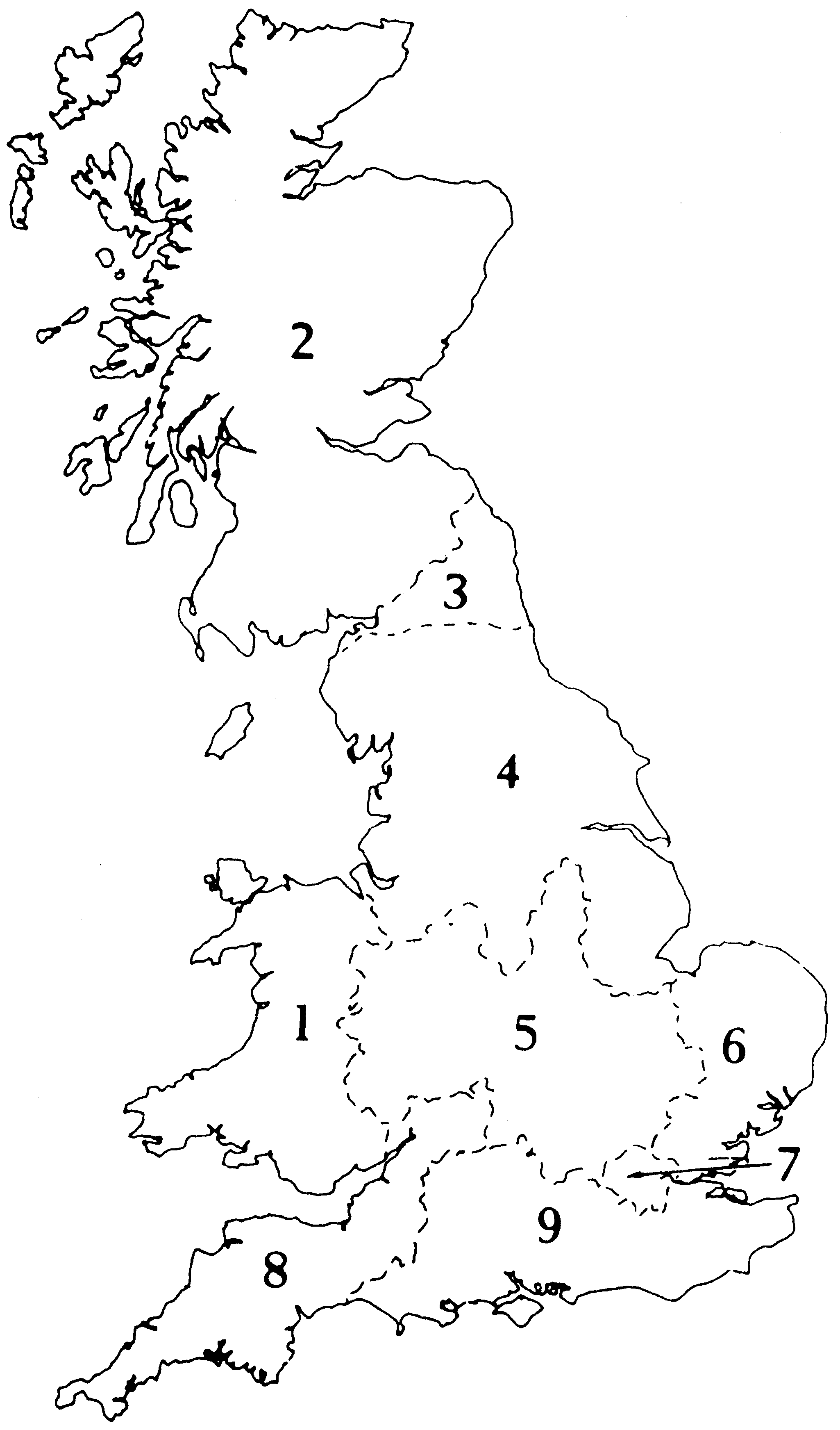
Key to numbered sections of Part I (Sites Explored).

CARMARTHENSHIRE
(1) Llandeilo, North Heronry Dam, Dinefwr Park (SN 6082 2276): a total of eleven trenches were opened to look for evidence of a possible Roman building suggested by surface finds and geophysical survey. Strong evidence, in the form of brick and tile, for a substantial Roman building was discovered, but its exact location could not be pinpointed. A series of ditches and gullies indicated that this was an intensively used landscape in the Roman period, laid out with fields and tracks. Pottery from the excavation suggests use of the site in the second to fourth centuries, therefore demonstrating that the building was not associated with the nearby forts at Llandeilo, which had been abandoned by that time. The building, therefore, may have been a temple located close to a spring, or, more likely, a villa.Footnote 2
(2) Llangadog, Llys Brychan Roman villa (SN 7048 2546): geophysical survey of the fields to the north of the villa revealed remains of not only part of the villa itself but also a series of ditches which formed a sub-rectangular enclosure of some 90 m by 80 m around it.Footnote 3 Three trial trenches were excavated to sample the enclosure. One to the north revealed a V-shaped ditch containing two sherds of black burnished ware. A second trench, located to sample parallel double ditches of the enclosure to the south-west, revealed an outer V-shaped ditch containing a piece of abraded samian and an inner U-shaped ditch. The third trench was located to investigate two geophysical anomalies on the easternmost ditch. A large pit was excavated with a charcoal-rich fill, suggesting some form of industrial activity. Due to adverse weather conditions and lack of time this could not be fully investigated. The pottery suggests the mid/late third to the mid-fourth century as the period of occupation of the site.Footnote 4
MONMOUTHSHIRE
(1) Caerwent, Museum Cottage (ST 4686 9071): part of the hexagonally-shaped wall of a large Roman building, which had originally been excavated in the early twentieth century, was exposed during an archaeological evaluation.Footnote 5 It was found that the structure had been seriously damaged by service trenches during the second half of the twentieth century. Part of a robbed wall that pre-dates the main structure was located protruding from the southern boundary of the site. Two linear features which were probably part of a drainage system were also thought to be Roman.Footnote 6
(2) Monmouth: (a) Agincourt Square (SO 50765 12827): results of a watching-brief and mitigation excavation support the view that the area was inside the early Roman fort. The closely datable pottery in the assemblage recovered is consistently pre-Flavian and similar to the material from the fortress at Usk. Later Roman remains superseded this context, while a sterile post-Roman deposit sealed them from early Norman levels.Footnote 7
(b) 33 Whitecross Street (SO 51040 12957): the main Roman deposit was dark loam which had survived on the western side of the site, lying directly over ancient alluvial sands. The Roman levels, which were in part associated with iron working, were sealed by a layer of fawn-coloured clay which also produced Roman pottery; this was sealed by medieval and later contexts.Footnote 8
(3) Portskewett, Sudbrook Road (ST 4997 8805): excavation on a sloping site overlooking a former tidal inlet of the Severn Estuary, which was navigable into medieval times. The site was enclosed on the southern and eastern sides by an earth-and-rubble bank flanked by a ditch. The eastern ditch was at least 4 m wide and 1.5 m deep; that on the southern side was less substantial, presumably due to the steep slope. The ditches produced second- to fourth-century pottery. Within the enclosure there was another stone-revetted bank and further ditches, but no structures were found.Footnote 9
(4) Undy, Meadow Bank House, Church Road (ST 43756 86840): stone foundations of a substantial Roman building were uncovered; finds included Roman pottery, coins and a well-preserved brooch.Footnote 10 The coins are Philip I, silvered denarius a.d. 244–249, Constantine I, commemorative issue a.d. 330–346, Constantine I, a.d. 307–337.Footnote 11
NEATH, PORT TALBOT
(1) Neath, Neath Port Talbot College, Dwr y Felin Road (SS 7485 9790): a watching-brief recorded a section of Roman road and associated roadside ditches. This supported the predicted location and alignment of the Roman road between the forts at Neath and Coelbren. Pottery retrieved from the road’s primary make-up layer indicates a second-century construction date, which would be consistent with the second phase of occupation at the nearby fort. Two pits and a gully recorded 15 m east of the observed Roman road are associated with activity relating to the previously identified civilian settlement.Footnote 12
NEWPORT
(1) Caerleon (Isca): (a) 14 Goldcroft Common (ST 3371 9071): archaeological evaluation revealed wall foundations of barrack blocks at a depth of 0.45 m. There were three structural phases, all presumed to be of fortress barracks. The first phase was marked by a heavy deposit of charcoal at the water table and appeared to be the remains of barracks constructed of timber. The second phase structure was of stone and was represented by a medieval robber trench cutting down to the water table. The final phase was represented by two walls built on rubble foundations.Footnote 13
(b) Isca Road (ST 3445 9020–ST 3455 9006): a watching-brief produced some evidence for industrial and domestic activity belonging to the Roman period.Footnote 14
(c) Fields to the south of the amphitheatre and Broadway Farm (ST 338 901): geophysical surveys (magnetometry) of the fields between the amphitheatre and the flood plain of the River Usk, extending south-west of the field surveyed in 2008.Footnote 15 The results revealed a series of very large masonry buildings on the ‘oblique’ alignment, around two sides of an area apparently free of archaeological features. Extending backwards from the façade of the building excavated by Nash-Williams in 1955 (‘Building XI’)Footnote 16 are at least two large square courtyards, enclosed by porticos or ranges of rooms leading towards the river’s edge.Footnote 17
(2) Langstone, Celtic Manor Coach Park (ST 376 922): evidence for the route of the Roman road linking Usk to Caerleon on the left bank of the River Usk, between ST 37583 92267 and ST 37679 92314, on the lower slopes of the Wentwood ridge and on the southern side of the river, was revealed. A secondary track, also probably of Roman origin, ran broadly parallel to the main road and appeared to serve a small, 3 m internally, single-celled, nearly square building at ST 37660 92277. The building was set back 20 m uphill from and overlooking the Roman road; the entrance was in the north elevation facing the Roman road.Footnote 18
POWYS
(1) Cil-Gwrgan (SO 1470 9333): a watching-brief produced further evidence for the course of the Forden Gaer to Caersws Roman road (RR64).Footnote 19 A layer of stone beneath the base of the modern road (A483) appeared to have been laid on top of a deposit of imported clay.Footnote 20
(2) Llansantffraid-ym-Mechain (SJ 2280 2062): a watching-brief identified a trackway consisting of compacted gravel containing nineteenth-century pottery. The track is depicted on the Ordnance Survey first edition map of 1886 (Montgomeryshire 10.7); its course appears to coincide almost exactly with the northern side of the putative Roman supply depot,Footnote 21 and is therefore likely to be the feature which was identified from aerial photographs and interpreted as part of the defensive circuit.Footnote 22
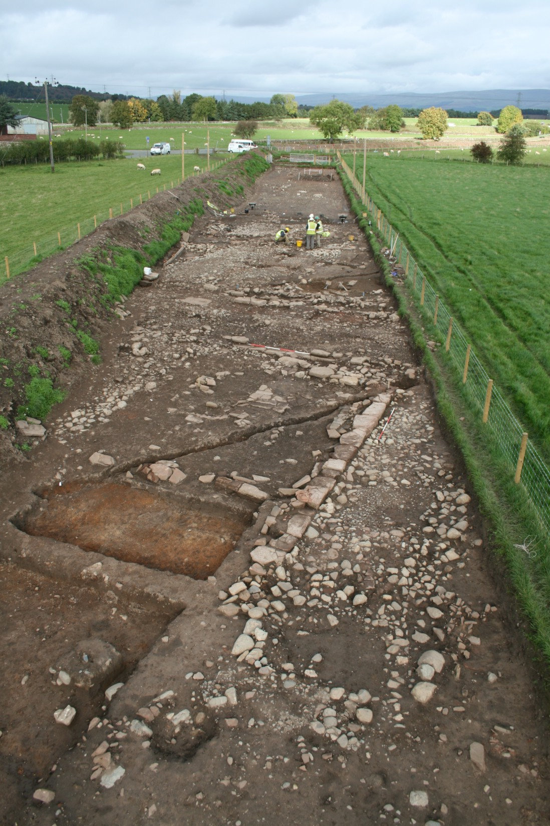
(3) Newtown, site of the old Smithfield (SO 1145 9147): excavations revealed a significant length of the Forden Gaer to Caersws Roman road (RR64). In total an area of around 3,115 m2 was mechanically stripped, in three areas, uncovering around 210 m of the Roman road. Three phases of road construction were identified, each consisting of a deposit of compacted river gravel. The earliest phase had been constructed on a base of imported clay, with a road width of around 4.5 m. It had a single ditch on the south-eastern side. A second layer of metalling was later laid directly onto the surface of the first, and the roadside ditch was recut, to form a wider and deeper feature. A number of wheel-ruts were identified in the compacted surface, while a coin was recovered from the make-up, suggesting that this phase was constructed in the early second century. The final phase saw a widening of the road to around 6 m, extending across the flanking ditch. While there was some evidence for roadside activity, in the form of stone spreads and limited areas of burning, it seems likely that a broad strip on either side of the road remained relatively sterile throughout its use, a feature also noted along other Roman roads. Although at least one stone surface is likely to be contemporary with the first phase of road construction, there was a general lack of stratigraphical or artefactual evidence to relate other features to the Roman road.Footnote 23
(4) Penstrowed (SO 0720 9083): a watching-brief and small-scale excavation identified a short section of the Forden Gaer to Caersws Roman road (RR64) in a field on the eastern side of the A490. In all 28 m of road were identified within the stripped area, following an alignment of 332 degrees. To the south of the excavation the road was less well preserved and a machine-excavated sondage some 35 m from the excavation failed to identify any surviving road structure. It was evident that the road had been severely truncated, but there was evidence for two phases of road construction. The earliest phase consisted of a deposit of compacted river gravel around 0.1 m thick laid directly onto the clay subsoil, with a layer of larger river cobbles, up to 0.15 m in size, above, forming the base for a road around 4.5 m wide, with no surviving surface. Along the eastern side of the road there was evidence for a second phase of road construction in the form of a thin layer of compacted river gravel which had been largely truncated by ploughing, surviving only where it dipped along the edge of the original road. A layer of silty clay separated the two phases. A shallow roadside ditch was identified along the western side, 0.9 m wide and 0.3 m deep. The corresponding ditch on the eastern side was not identified within the excavated area.Footnote 24
(5) Walton, Four Stones (SO 2468 6065): excavations revealed several features of Roman date, lying around 1 km west of Hindwell auxiliary fort. The main feature was a short length of ditch, which contained a significant quantity of Roman pottery dating to the late third to fourth century, as well as a fragment of a rotary quern. The ditch, which was aligned north–south, was around 1.1 m wide and up to 0.6 m deep, and was butt-ended at its southern terminus. The profile was generally V-shaped, with a noticeable slot 0.25 m wide in its base, which became more pronounced further from the butt-end. There was a suggestion that the ditch may have turned to the east at the point at which it intersected with the eastern edge of the excavation. A second, shallower Roman ditch was identified further to the south, which was V-shaped, and c. 0.9 m wide and 0.35 m deep. Pottery recovered from the fill included a Severn Valley ware tankard and sherds of black burnished ware.Footnote 25
VALE OF GLAMORGAN
(1) Llanmaes, Tremains Farm (SS 984 688): geophysical survey revealed a series of fields or enclosures in the northern half of the site, which could be part of a much more extensive Roman settlement.Footnote 26 A number of the ditches associated with the system were sampled but none produced a datable artefact assemblage. A sample taken from ditch 14104, however, contained plant remains that suggest an Iron Age or Roman date for the feature. At present this dating remains tentative.Footnote 27
(2) St Athan: (a) Batslays Farm (ST 003 679): dating evidence provided by the excavated features suggests that the complex of geophysical anomalies found in the south-west corner of the site represents a Romano-British agricultural settlement. A trackway and rectilinear enclosure or field boundaries lie to the east and north-east of the settlement, with the limited evidence suggesting they too date to the Roman period. Pottery recovered from this settlement suggests that it was in use from the second to fourth centuries.Footnote 28
(b) MoD St Athan (ST 002 686): evaluation work revealed a large number of features, both linear and discrete. None could be dated from artefact assemblages, but samples taken from gully 16604 and post-hole 16606 contained plant remains consistent with an Iron Age or Roman date. It is possible that the features on this site are related to or contemporaneous with the Iron Age and Romano-British settlement excavated on the site of the Red Dragon Hangar some 500 m to the north-east,Footnote 29 or the Batslays Farm settlement, reported above, c. 550 m to the south-east.Footnote 30
2. SCOTLAND
NORTH OF THE ANTONINE WALL
MORAY
(1) Birnie (NJ 210 585): continued excavationFootnote 31 of this Iron Age settlement produced a further Romano-British broochFootnote 32 and indigenous pottery influenced by Roman pot forms.
ANGUS
(1) Finavon (NO 4959 5747): a limited watching-briefFootnote 33 within the temporary camp found no Roman remains.Footnote 34
PERTH AND KINROSS
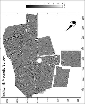
(1) Inchtuthil (NO 125 397): (a) magnetic and resistivity surveyFootnote 35 of the legionary fortress and its environs largely confirmed the plan from excavation and aerial photography,Footnote 36 although the buildings are less neatly rectangular than had been extrapolated from trial trenches (fig. 2). A previously unknown structure was revealed between the two north-western granaries, while a substantial magnetic anomaly in the south-east corner of the fabrica may be a further iron hoard; this building also shows magnetically-enhanced activity in its northern range. An oval feature c. 80 m longFootnote 37 lies outside the east gate; the barrow cemetery to the north is more extensive than now visible. West of the fortress, a series of pits was revealed. To the south-east, results confirmed aerial indications that activity extended beyond the known temporary camp up to the fortress defences; field-walking recovered quantities of Roman finds and extensive traces of lead-working, suggesting an external settlement and perhaps an industrial zone. (b) Garden Cottage, Delvine Gardens (NO 1286 3945): evaluationFootnote 38 of a development site immediately east of the fortress and south of the Redoubt, adjacent to the road line, found no surviving trace of Roman remains.
Magnetometer survey of the legionary fortress at Inchtuthil. (Courtesy of Dr D.J. Woolliscroft)

(2) Standingfauld (NN 866 134): aerial surveyFootnote 39 located quarry pits of the Gask road c. 200 m east of the Ordnance Survey line.
(3) Shielhill North (NN 8559 1216): excavationFootnote 40 to the south-west of Shielhill North watch-tower, where the Roman road branches, showed that both routes were in excellent condition, though no dating evidence was recovered. The branch line was less well-built, comprising a relatively loose layer of fist-sized stones; it followed easier gradients, with slight cuttings and embankments across the stream valley to the east.
(4) Forteviot (NO 0537 1739): unstratified sherds of Roman pottery were found during excavationFootnote 41 of a Pictish cemetery and adjacent enigmatic square enclosure; features within the enclosure suggest a role in funerary rites.Footnote 42
FALKIRK
(1) Lochlands (NS 8561 8171): excavationFootnote 43 in the north-west of the largest camp revealed the corner of a smaller, previously unknown, earlier camp (fig. 3). The inner of two parallel ditches previously exposed on its west sideFootnote 44 comes from this camp; it was left open to form a double ditch to the larger camp on this side, although the northern ditch of the small camp was backfilled. A palisade slot was subsequently cut into the western side of the outer ditch after it was mostly backfilled. A figure-of-eight field-oven within the smaller camp preserved charred branches from the fire; the lack of clay or turf in the fill suggests it was unroofed. Among other internal features was a rectangular pit-hearth with a heated clay base.
(a) Location of the excavations in the Lochlands camp complex. (b) Plan of the excavated areas, 2007 and 2009. (Courtesy of G.B. Bailey)

THE ANTONINE WALL
NORTH LANARKSHIRE
(1) Westerwood (NS 7606 7741–7619 7739): a watching-briefFootnote 45 on a service trench just within the northern rampart of the fort disturbed no archaeological remains.
(2) Croy Hill (NS 731 766): detailed topographic survey of a 2 km stretch of the Wall and associated remains was undertaken around Croy Hill.Footnote 46 New discoveries were all post-Roman.
EAST DUNBARTONSHIRE
(1) Kirkintilloch, St Flannan’s church (NS 663 742): a series of small watching-briefsFootnote 47 immediately south of the Wall line found no certain Roman remains. A deposit exposed in one trench may represent the upper fill of the Ditch at NS 66255 74315, to the south of the Ordnance Survey line but consistent with previous work;Footnote 48 too little was exposed to confirm the identification.
(2) Bearsden, 16 Roman Road (NS 5463 7203): an evaluationFootnote 49 within the fort’s annexe showed that archaeological deposits survived only in the west and south of the area.Footnote 50
SOUTH OF THE ANTONINE WALL
FALKIRK
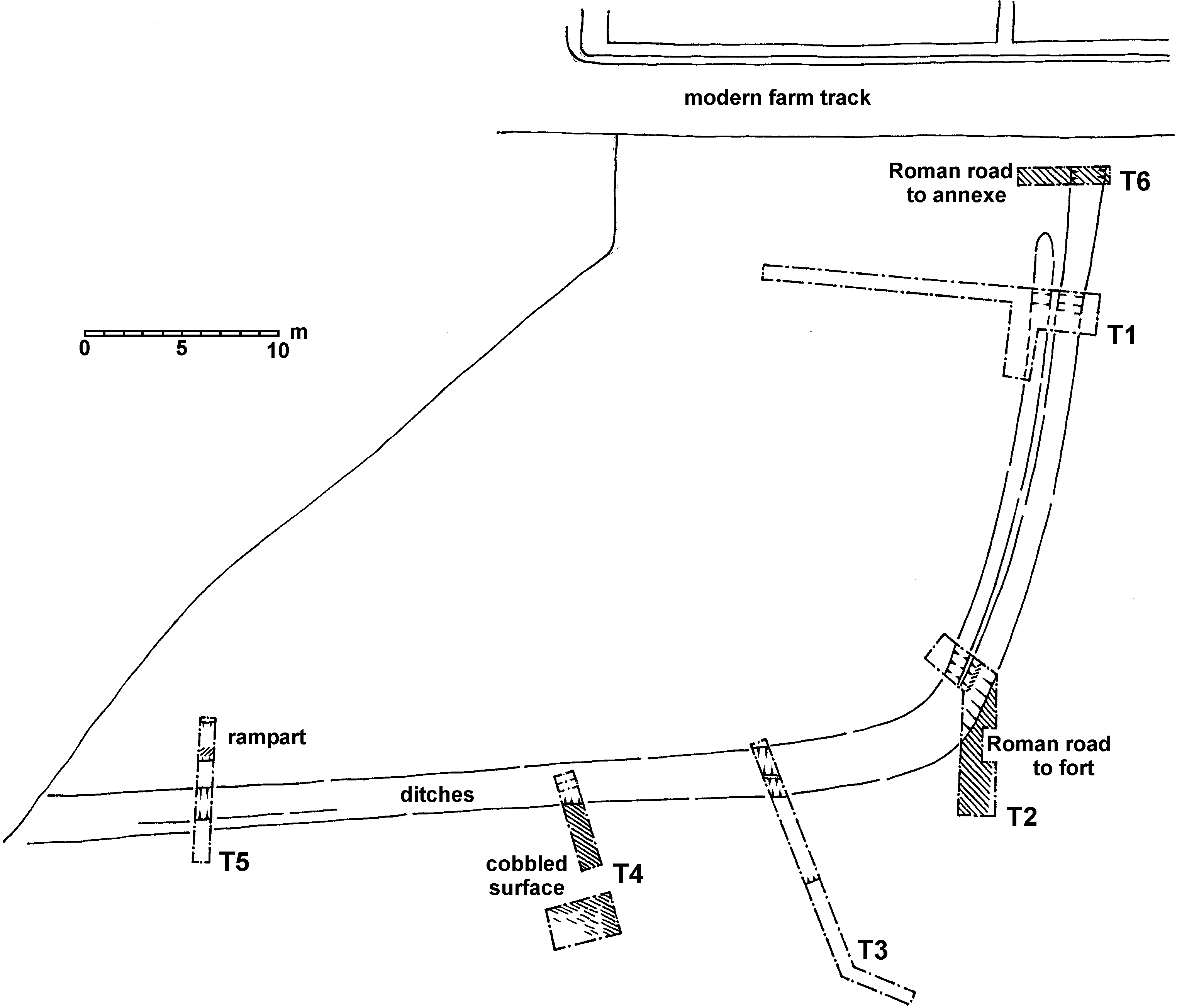
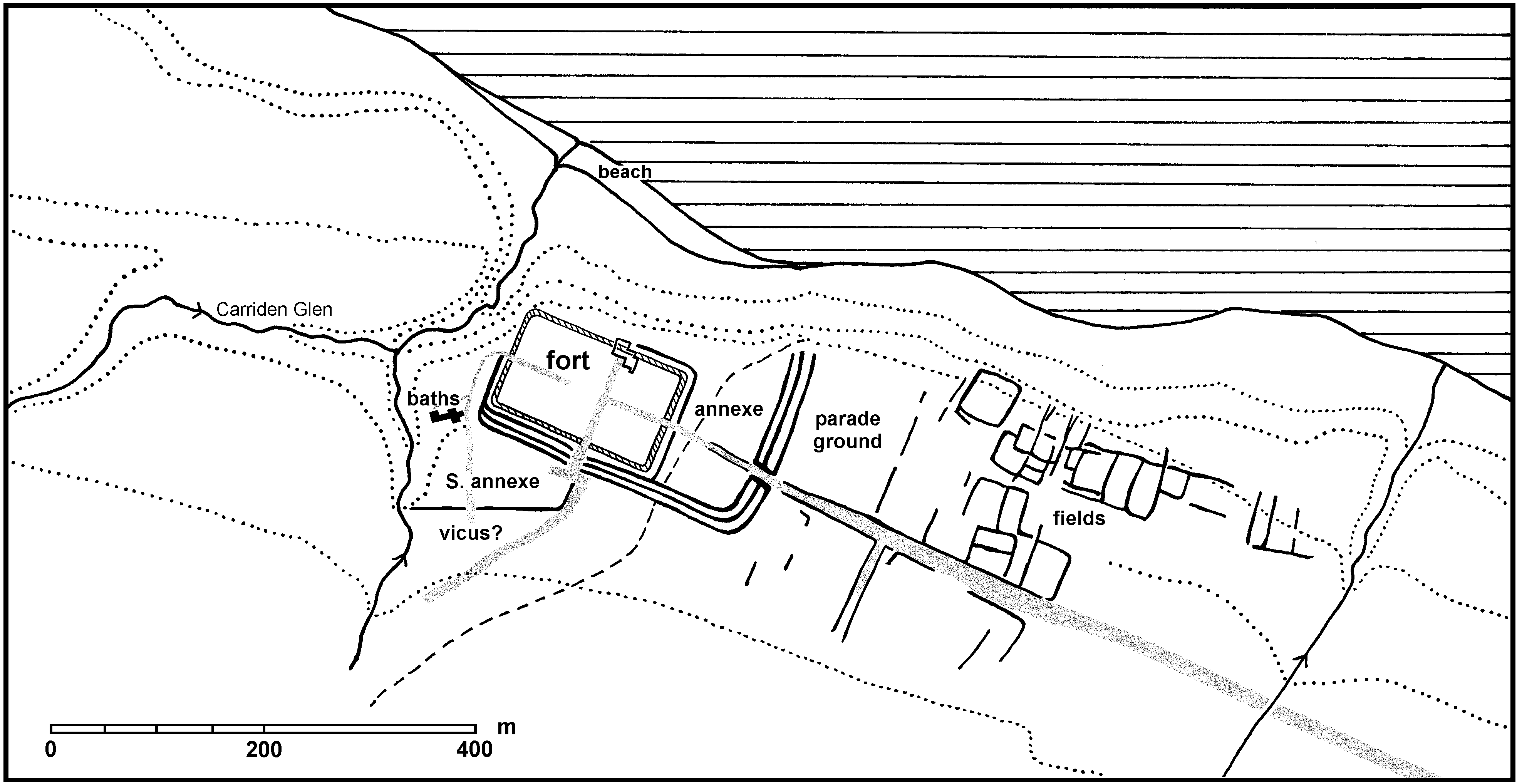
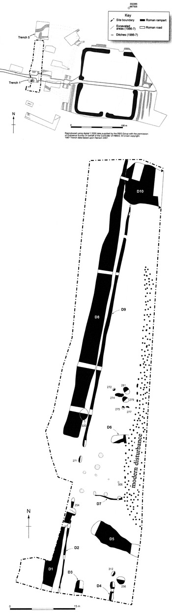
(1) Carriden: (a) (NT 021 810): three further north–south magnetometer transects,Footnote 51 160–200 m long, to the west of the fort and east of Carriden Brae Road, found no continuation of the Wall or Ditch. (b) (NT 024 807): sections dugFootnote 52 across an enclosure south of the fortFootnote 53 revealed a two-phase ditch (fig. 4). The substantial inner ditch probably defended a southern annexe enclosing the bath-house;Footnote 54 a cobbled rampart base survived in places. It was overlain at its north end by a road, and cut in places by the later, smaller ditch; the latter is possibly a water channel, cut into clay and acting as an aqueduct for the fort. There are traces of a road running approximately north–south, just outside (east of) the ditches, approaching the south gate, while cobbling and other features beyond the ditches indicate extramural activity. The recent fieldwork and scrutiny of aerial survey and geophysical evidence have suggested a re-interpretation of the site’s layout,Footnote 55 with the fort sitting at the west edge of the plateau, overlooking the burn, and annexes to east and south (fig. 5).
The southern annexe at Carriden, with trench locations. (Courtesy of G.B. Bailey)

Suggested revised layout of the fort and associated features at Carriden. (Courtesy of G.B. Bailey)

(2) Muirhouses (NT 0166 8067): magnetometer surveyFootnote 56 of a broad transect over the camp’s northern rampartFootnote 57 confirmed the presence of a semi-circular featureFootnote 58 immediately inside the entrance, and located parts of two ditches meeting at an angle some 70 m beyond the camp; more work is planned to explore these features.
CITY OF EDINBURGH
(1) Cramond: a series of area and linear array resistivity surveys was conductedFootnote 59 to clarify previous results around the periphery of the fort site. (a) Cramond Tower Drive (NT 1908 7696): a ditch previously located in this area does appear to join the fort’s east ditches.Footnote 60 (b) Manse grounds (NT 1899 7676): survey was hampered by later features; the fort’s south wall was located, with parallel stone structures within, but no trace of a ditch. (c) Cramond House parkland (NT 1920 7693): two linear arrays over the edge of the raised beach suggested the enclosure line located previously 60 m to the eastFootnote 61 had split into two ditches 7 m apart by this point; one may align with the ditch noted in (a) above. (d) Cramond House Kennels (NT 1899 7695): linear resistance arrays located a series of anomalies representing one or more V-shaped ditches c. 30 m north of the Severan fort wall. These correlate with a previously excavated feature much disturbed by later activity,Footnote 62 and may represent the Antonine fort ditch.
WEST LOTHIAN
(1) Castle Greg (NT 0502 5925): resistivity surveyFootnote 63 over about half of the fortletFootnote 64 revealed high-resistance features in its centre and against the southern rampart.
MIDLOTHIAN
(1) Elginhaugh (NT 3215 6740): excavations exposed much of the western dividing ditch and entrance of the major subdivision in the fort annexe (fig. 6).Footnote 65 The basic sequence of these defences was confirmed,Footnote 66 with an earlier gully and later ditch; more detail of the entrance through the gully system was revealed, with two linear pits on the line of the gully restricting the entrance space. The gateway was confirmed as an eight-post structure, with a slot along the rear of the southern edge to limit access. A substantial east–west ditch complex at the northern end, representing three converging ditches (one notably broad and flat),Footnote 67 suggests that the northern annexe defences were more complex than realised; they merged with the north–south annexe ditch, but no relationship could be discerned. Further evidence of subdivision in the annexe came from a previously unknown north–south ditch at the southern limit of excavation, its extent unknown. An as of Trajan from the upper fill of the southern funnel ditch pushes the post-occupation use of the site (argued to represent a collection centre for animals) later than suspected. Notable among a thin scatter of internal features were possible remains of a building and adjacent well, although the latter was only partly excavated.
(a) Location of the 2009 excavations in the Elginhaugh annexe. (b) Plan of the 2009 excavations. (Courtesy of Headland Archaeology)

SCOTTISH BORDERS
(1) North Slipperfield (NT 129 520): a watching-briefFootnote 68 within the temporary campFootnote 69 found no trace of internal features.
SOUTH LANARKSHIRE
(1) Kirkhouse (NT 097 462): a small watching-briefFootnote 70 within the temporary camp uncovered no Roman remains.
(2) Woodend (NS 9496 2792): an evaluationFootnote 71 uncovered a quarry pit connected to the road from Crawford to Inveresk.Footnote 72
SOUTH AYRSHIRE
(1) Girvan Mains, Knockavalley Cottages (NX 1918 9900): two watching-briefsFootnote 73 within the temporary camp complexFootnote 74 found no associated features.
DUMFRIES AND GALLOWAY
(1) Dalswinton: (a) Bankhead (NX 9331 8485): magnetic surveyFootnote 75 revealed details of the two superimposed forts and their annexes; while the northern annexe produced rather few features, the eastern annexe showed more activity. (b) Bankfoot (NX 934 840): magnetic surveyFootnote 76 covering much of the large camp revealed numerous anomalies, probably field ovens. Survey also examined part of the double-ditched enclosure which has been seen as a vexillation fortress,Footnote 77 but the lack of internal features suggests it too was a temporary structure. (c) Butterhole Brae (NX 9364 8447): magnetic surveyFootnote 78 added some detail to the enclosure system of the possible fortletFootnote 79 to the north-east of Bankhead fort.
(2) Ward Law (NY 0240 6687): magnetic surveyFootnote 80 over the northern part of the campFootnote 81 confirmed the lack of a break at the titulus on the western side, suggesting two phases to the camp’s use with the entrance being modified. The complex northern titulus was obscured by geological anomalies; no obvious internal features were recorded.
3. ENGLAND HADRIAN’S WALL
SOUTH TYNESIDE
(1) South Shields fort (Arbeia) (NZ 365 679): following completion of excavation inside the east quadrant of the fort last year, a new trench 150 sq m in area was opened 15 m south-west of the southern angle of the fort in order to assess the preservation of the ditch system and vicus. Beneath 1.5 m of overburden (consisting mainly of ship ballast), plough-damaged Roman stone structures were encountered at a distance of 30 m from the south-western fort wall, running on the same south-west to north-east alignment as the fort. These buildings will be further explored in 2010.Footnote 82
NEWCASTLE
(1) Benwell, Trinity School (Oakfield College Site), Condercum Road (NZ 2180 6449): an area covering c. 830 m2 was excavated on the northern valley side of the River Tyne, following up an evaluation earlier in the year which identified likely Roman period remains. The site lies within 150 m to the south-east of the Hadrian’s Wall fort of Condercum. The main Roman period features recorded in the excavation were a sunken metalled trackway running downslope and a substantial ditch — up to c. 2 m wide and up to 1.2 m deep — probably representing the south-eastern right-angled corner of an enclosure laid out during the second century a.d. but evidently re-established, slightly further west, during the second to third century. Within the enclosure a possible timber slot, a possible infant burial, and a shallow pit were recorded. In sum, these remains potentially represent the south-easternmost extent of the vicus of Condercum.Footnote 83
(2) Newcastle-upon-Tyne, 1–7 Westgate Road (NZ 2497 6387): numerous service pits and drainage routes were excavated after an evaluation in 2007 had identified the presence of remains of Roman and medieval date. Deeply stratified Roman period remains were recorded, for the most part dating to the first half of the third century. The walls of a substantial sandstone structure were recorded, possibly an element of the Roman fort Pons Aelius, along with a portion of a road and other remains likely representing extramural activity in the vicus settlement to the west of the fort.Footnote 84
(3) Walker, Fossway (NZ 2857 6541): an evaluation in 2008 in advance of service renewal found the clay and rubble core of Hadrian’s Wall in the grass verge between the road and the footpath on the south side of the Fossway, immediately west of its junction with Whinneyfield Road. No facing stones were observed.Footnote 85
NORTHUMBERLAND
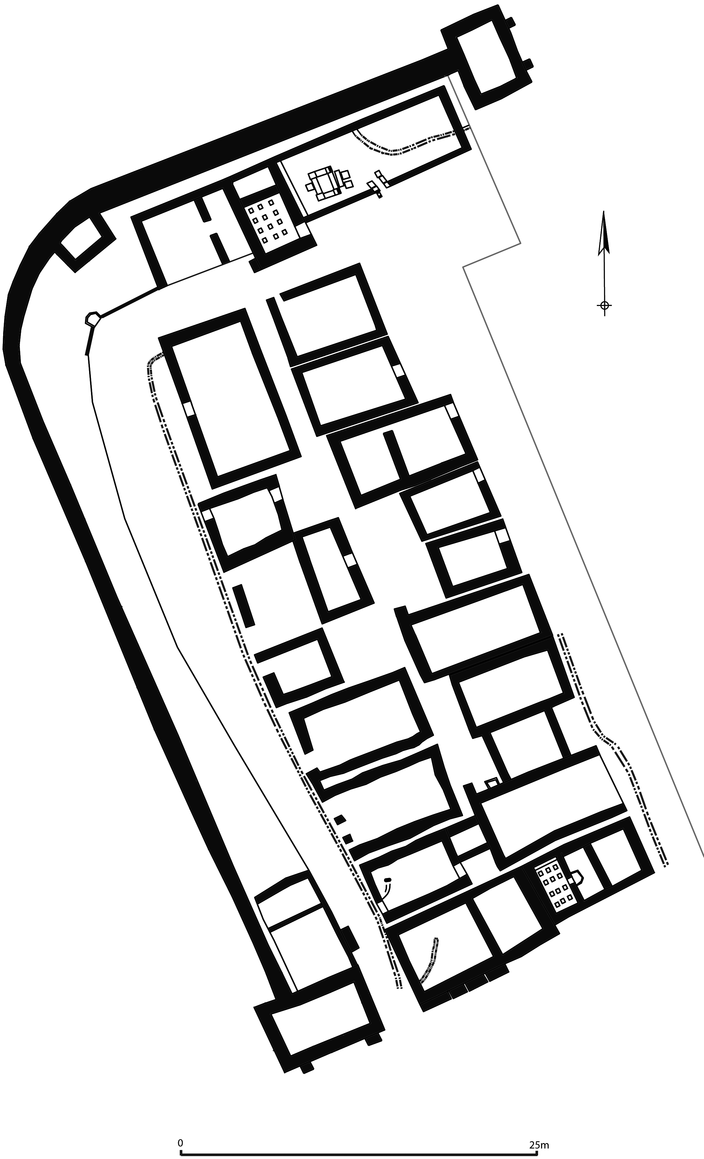
(1) Vindolanda (NY 768 663): (a) excavationsFootnote 86 within the fort (fig. 7) concentrated on exploring the nature and significance of the fourth-century and post-Roman occupation in the north-west quadrant. Between the granaries and the northern and western fort walls 22 buildings were examined. Most appear to have been built directly over the demolished remains of earlier third-century barrack blocks or workshops. The fourth-century structures appear to have been used for a wide variety of purposes, ranging from accommodation to workshops, store-rooms (including enclosed yards), and to three buildings which may have served social functions. There was very little to suggest that this area contained ‘chalet type’ barrack blocks as found elsewhere in the fort,Footnote 87 although by keeping the earlier road network intact, the fourth-century builders constrained their structures to within the boundaries laid down by perhaps more traditional third-century plans. The buildings on the northern and southern limits — a temple to Dolichenus against the northern rampart mound and a possible schola across the road from the granaries — had been furnished with heated rooms, perhaps indicative of their higher status. A third building, which was situated on the rampart mound adjacent to the west gate, was the only one to produce painted wall-plaster, of the highest quality so far recovered from any third- or fourth-century building on the site. It is possible that this may also have been a shrine, situated like the temple to Jupiter Dolichenus near a gateway, but if this was the case the deity remains unknown. The excavation of this building will be completed in 2010. The temple to Jupiter Dolichenus on the northern rampart, to the west of the north gateway, produced three altars, all of which were probably of third-century date. At present it is impossible to be certain if the worship of the cult of Jupiter Dolichenus thrived at Vindolanda into the fourth century, but it would appear from the coins and other datable artefacts recovered that the temple precinct was respected well into the middle of the fourth century, before it was thoroughly demolished. After demolition the remains of the building were heavily burned before the site was completely abandoned. Almost all of the late Roman levels in the north-western quadrant were capped by debris from subsequent occupation (the Dolichenum aside), which, although sometimes fragmentary in nature, extended across a wide area. In most cases the remains of post-Roman buildings were only traceable through surviving roughly-paved platforms, wall foundations and the occasional post-pit or sunken feature. The post-Roman occupation levels were almost completely void of any trace of associated material culture.
Vindolanda, the 2009 excavation site in Stone Fort 2, with the Dolichenum immediately to the west of the North Gate.

(b) Excavation continued in the south-west of the vicus, immediately north of the area examined in 2008.Footnote 88 Evidence for successive phases of Roman activity was found, ranging in date from mid-second century to c. a.d. 270. There were traces of a timber structure of mid-second-century date containing silver birch upright posts, with oak boarded panels. Overlying the timber structure, a stone-built gateway was found, with associated defensive features including a rampart revetment and ditch. The gate had been a single portal, 2.65 m wide with only one course of masonry surviving above its foundations, constructed of coursed rubble bonded with clay, but its quoins were more finely dressed. Both door pivot holes had survived relatively unworn and measured 100 mm in diameter. A cobbled roadway exited from the gate towards the west, flanked on either side by shallow drains, with a further drain running through the centre of the gate portal. The roadway had been resurfaced at least once, at which point the central drain had been covered. The rampart revetment consisted of a single line of rubble blocks and was traced for 14.26 m to the south of the gateway. A linear band of clay, likely to have been the remains of the rampart itself, was attached to its east side and was 2 m wide. These features appear to represent the remains of a gated enclosure, or annexe, attached to the western side of Stone Fort 1. By the turn of the third century the defences had been abandoned, or demolished, and ditches were cut through the area as defences for the south-west corner of the Severan establishment. A section was excavated through the main, inner, ditch, and traces were also found of a second, outer, ditch, measuring 2.10 m wide and 870 mm deep. It had filled up naturally with sand and silts before being capped with clay. Evidence for the third-century vicus was relatively slight. A major cobbled roadway, 12.5 m wide, leading north-west from the industrial workshops identified in 2008, was traced for a distance of 30 m. However, severe disturbance to the uppermost Roman soil surfaces by post-Roman agricultural activities meant no associated structures could be identified. The coinage and ceramic evidence recovered suggested little or no activity
(c) 2009 saw the start of a series of smaller scale excavations to the north of the modern line of the Stanegate road which are being instigated to check the extent and the nature of the archaeology of that area in the light of an earlier magnetometer survey. Two superimposed Roman buildings were discovered as well as drainage features and indicators of industrial metal working. The largest of the buildings, 12.0 by 21.0 m, dating from the third century, appears to have been an aisled barn or storage facility set at the edge of the extramural settlement. Due to extensive damage from post-medieval ploughing and field drainage work, very little of the floor surfaces remained intact and few artefacts were recovered. Further work in this area is planned for the summer of 2010.
CUMBRIA
(1) Birdoswald (Banna) (NY 619 660): continuing erosion of the river cliff upon which the cemetery is located led to the excavation of a broad area on the cliff edge in order to recover archaeological deposits under short- and medium-term threat. A cobbled road was found leading up from the fort and civilian settlement. On the side of this road was a ditched enclosure, within which were cremation burials and commemorative deposits dating from the second to fourth centuries. It was apparent that a great deal of the enclosure had already been lost to erosion. A range of rites was present, including the burial of cremated remains in simple pits, stone-lined cists, wooden boxes and pottery vessels; there were also two examples of busta. Grave goods included pottery vessels, a fused-glass vessel and iron nails. In one of the pots containing cremated bone were several copper-alloy annular objects, and a fragment of chain mail. The entrance to the enclosure was blocked by two inhumation burials laid end-to-end. Dating evidence suggests that these were late fourth- or fifth-century, and probably, therefore, Christian. Their positioning in the entrance to the enclosure may have been a deliberate ritual sealing.Footnote 89
4. NORTHERN ENGLAND
NORTHUMBERLAND
(1) Thirston: 103 silver denarii ranging from Vespasian to Severus Alexander deposited c. a.d. 227.Footnote 90
CUMBRIA
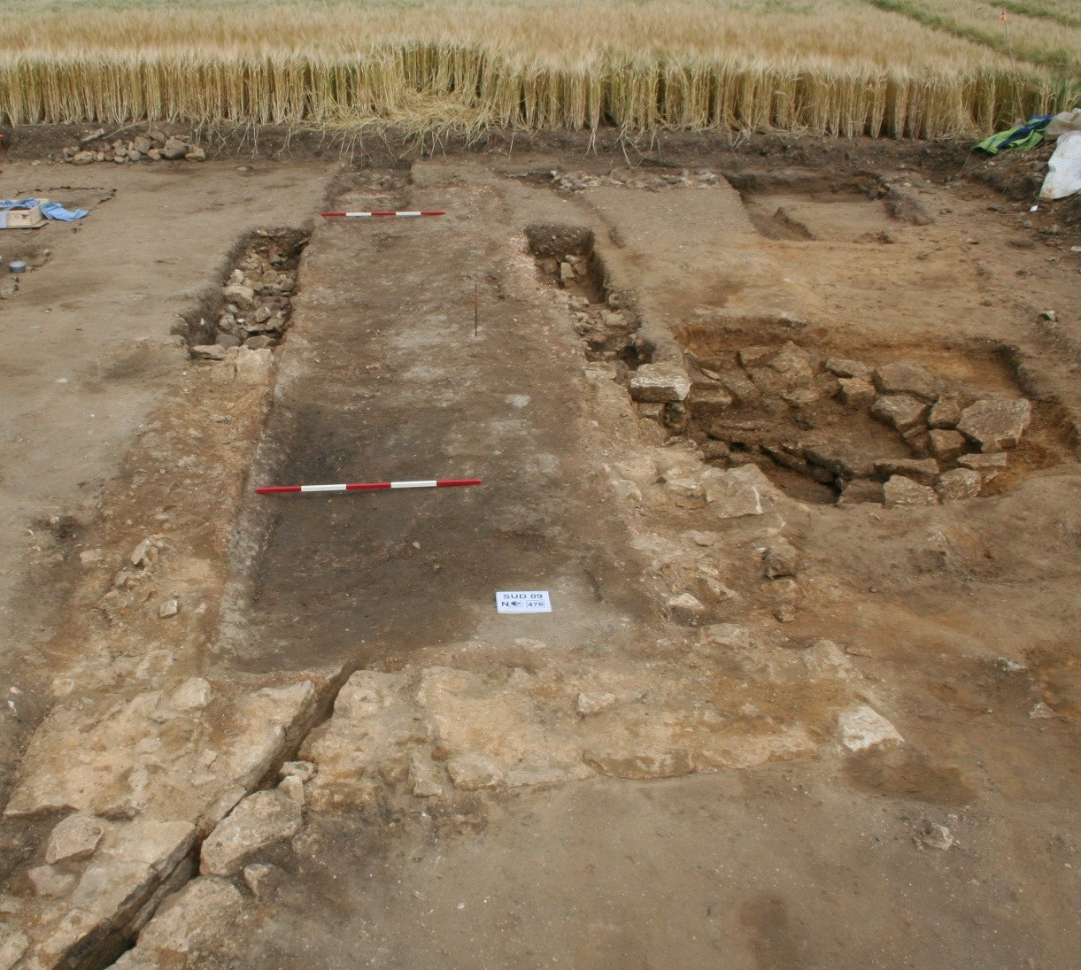
(1) Brougham (Brocavum) (NY 53812 28593–54466 28900): an excavation along the proposed route of a pipeline to the south-east of the fort at Brougham was implemented following the discovery of in-situ Roman remains during an evaluation of the easement. The earliest remains to be excavated included a substantial metalled surface, aligned north–south and probably forming part of a main road close to the south-east corner of the fort. The remains of at least three buildings, also belonging to an initial phase of Roman activity, were revealed fronting onto the road at a distance of approximately 100 m from the south gate of the fort. The footprint of each building was marked by a series of shallow foundation trenches for timber sill beams, with spreads of compacted clay representing internal flooring. The foundations of the earliest buildings were sealed beneath a second metalled surface that was laid perpendicular to the main road, denoting an expansion of the Roman settlement. The stone foundations of three large buildings were exposed at the junction of the newly laid surface and the main road (fig. 8). The fragmentary remains of stone flooring and hearths were identified within the footprint of the buildings, whilst the presence of several sandstone tiles in overlying deposits indicated that at least one had had a stone roof. The vestiges of several cremation burials were identified some 440 m to the east of the excavated buildings, probably signifying the eastern fringe of the Roman cemetery that was excavated in 1966–7.Footnote 91 Numerous U-shaped ditches that were revealed between the excavated buildings and the cremation burials may have represented elements of a field-system. Within one area, a series of eight ditches was exposed, creating well-defined, sub-rectangular plots, each measuring 10 m by 5 m. Preliminary examination of the material assemblage has provided dates ranging from the early second to the fourth centuries, with the majority of artefacts being of late second- and third-century provenance. The assemblage incorporates numerous fragments of jewellery, including a Whitby jet pendant and ring, and a gold-in-glass bead dated to c. a.d. 175.Footnote 92
The extramural settlement at Brougham, Cumbria: third-century buildings and lanes adjacent to the road leading south from the fort. (© Oxford Archaeology North)

(2) Cunningarth (NY 2685 4637): a desk-based assessment and evaluation was undertaken in advance of development. A ditch orientated north to south was identified as being of Roman date. It contained sherds of unabraded second-century Roman pottery and glass. The V-shaped cut of the feature is also a typical profile for larger Roman ditches. Two undated ditches running on an east–west alignment were also identified. The second-century date is broadly contemporary with the second- to third-century dates obtained for the nearby Old Carlisle Roman fort and vicus and the ditches may have been part of an associated field-system.Footnote 93
COUNTY DURHAM
(1) Binchester (Vinovia) (NZ 2101 3134): the first season of a new five-year campaign of excavation took place in 2009, beginning with an area in the dextral half of the praetentura encompassing the east corner of the fort interior.Footnote 94 The remains of the east angle-tower were exposed along with one side wall of a possible interval-tower on the north-east defences and an oven or kiln behind the rampart on the south-east side. The uppermost surface of the intervallum road was revealed along with the outer end of a long, narrow masonry building — seemingly a barrack — aligned per strigas. In its final guise this was c. 7.40 m wide, though there are signs that the building was about 11.5 m wide in the preceding phase, extending further to the south-east. Traces of internal partition walls suggest the layout of the interior space was modified on several occasions. One area of the interior was equipped with a floor of heavy stone flags that includes several pieces of re-used architectural stonework. A number of post-settings suggest one or more later structures of timber, though these are undated.
(2) Bowes (Lavatris), Bowes Manor (NY 9904 1304): an archaeological evaluation was conducted in response to a proposed residential development.Footnote 95 The site in question lies some 70 m outside the east wall of the fort and immediately north of the assumed line of the road leading to the east gate. It also lies west and south-west of Holme Lea where a previous evaluation was carried out in 2008.Footnote 96 Two trenches were excavated and in one of these a spread of heavy cobbles was encountered, assumed to represent the road leading to the east gate of the fort. The second trench revealed the walls of a masonry building of probable third-century date overlying a considerable build-up of deposits presumably derived from earlier structures. Associated pottery ranged in date from the late first to the early fourth century.
(3) Chester le Street (Concangis), Auckland Cottage (NZ 2752 5124): excavations were conducted in the grounds of Auckland Cottage, situated mid-way between Middle Chare and High Chare and immediately south of the assumed line of the south wall of the fort. Elements of the west and north walls of a stone building with a flagged floor were revealed. A 4 m-wide street lay immediately to the west and traces of another of similar width was found to the south giving the flagged chamber a maximum north–south dimension of c. 11 m. There was no sign of the fort ditch. The building just described had been erected in the mid to late third century and overlay the infilling of an earlier cut-feature at least 4 m wide and at least 1.5 m deep running north–south. The latter aligns with and is similar in profile to the ditch of the western defences of the primary fort encountered near the north-west corner of the fort during the 1991 Church Chare excavation and is interpreted as a continuation of such.Footnote 97 A barrack block of the late third-century fort had subsequently been erected over this ditch. The characteristics of the building and streets found at Auckland Cottage and the absence of any sign of the anticipated south ditch of the later fort suggest these features were intramural and thus that both the primary and secondary forts extended further south than previously thought. Topographical factors suggest the southern limit of the fort lay c. 25 m out from the line conjectured earlier, the streets found at Auckland Cottage forming the south-west angle of the via sagularis and the structure the south end of a barrack arranged per strigas. This would give the later fort an overall length of c. 190 m, thus increasing its size from the previous estimate of 2.5 ha (6.17 acres) to 3.04 ha (7.52 acres).Footnote 98
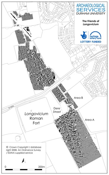
(4) Lanchester (Longovicium) (NZ 1596 4706): further geophysical survey was carried out in the vicus, both extending the area surveyed in 2008 along Dere Street north-west of the fort and also along Dere Street south-east of the fort for a distance of c. 250 m (fig. 9).Footnote 99 The north-west area, on the far side of a stream and area of boggy ground, was devoid of buildings and appears to mark the limit of the built-up area in this direction. To the south-east, both sides of Dere Street were lined with typical civilian strip-buildings for a distance of c. 250 m out from the south-east angle of the fort. An arrangement of ditches can be seen defining plots behind the buildings with a back lane at the rear of those to the east of Dere Street. Roughly opposite the fort gate and some distance back from the east side of Dere Street there appears to be a double-ditched enclosure measuring c. 40 m across. It seems out of character with the rest of the settlement and may pre-date or post-date the vicus.
Lanchester, plot of geophysical surveys of the vicus.

(5) Sedgefield, East Park (NZ 3505 2894): the remainder of the open area between Sedgefield, the A177 and the A689 was subjected to geophysical survey to recover further details of the settlement investigated during the summers of 2005–8 (fig. 10).Footnote 100 The system of enclosures continued along both sides of the Roman road (often referred to as Cade’s Road) as far as, and probably beyond, the boundaries of the available area. The minimum size of the settlement is now estimated at 30 ha.
East Park, Sedgefield, plot of geophysical survey.

DARLINGTON
(1) Piercebridge (NZ 2103 1575): geophysical survey and evaluation excavation as part of a Time Team investigation produced the following results. (i) Several buildings were sampled in the area west of the north-west corner of the late fort. These were on a different alignment to the latter and appear to belong to the second/third-century civil settlement that preceded it which thus extended over a far wider area than previously thought.Footnote 101 (ii) Geophysical survey in Tofts Field east of the fort revealed a series of parallel ditches following a north-west/south-east alignment and continuing to the bank of the Tees close to the site of the early bridge. Excavation of one of these features showed that it was in fact a sunken way, equipped with a cobble surface and masonry revetting walls, leading down to the river and presumably a ford alongside the bridge. (iii) Samples were taken for radiocarbon dating from timber piles belonging to the original Dere Street bridge. (iv) Samples taken from another timber structure situated c. 150 m further upstream, possibly belonging to the remains of yet another bridge or crossing, yielded 14C dates of 15–75 cal. a.d. (68.3% probability) at 1 sigma and 40 cal. b.c.–80 cal. a.d. (94.3% probability) at 2 sigma.Footnote 102
NORTH YORKSHIRE
(1) Aldborough (Isurium Brigantum) (SE 405 665): 2009 saw the initiation of a geophysical and topographic survey project intended to establish a detailed plan, covering both the intra- and extramural areas of the town. The objective is to allow the study of the architectural as well as spatial planning of the town and perhaps track its development over time. The season’s survey covered three areas located on or outside the walls, as well as in the centre of the town around the excavated mosaics. The results of these surveys were very successful in identifying parts of the street system, houses, defences and previously unknown extramural settlement areas. Outside the south gate, a series of buildings were identified running parallel with the ditch systems of the defences. Within the town, around the preserved mosaics, the full complexity of the town was revealed, showing streets, buildings and rooms. An area of geophysics was also carried out over an area of the wall between the north and west gates. This area had in part been examined previously; trenches were excavated over the wall in the 1930s,Footnote 103 and more recently, a small area of resistance survey was carried out in the 1980s.Footnote 104 The project also aims to draw together previous work on the site.Footnote 105
(2) Aiskew: (a) Aiskew Grange Farm (SE 272 899): an evaluation was carried out along the line of the proposed Bedale, Aiskew and Leeming Bar bypass. Geophysical survey detected an intense rectilinear anomaly on fields west of Aiskew Grange Farm. Subsequent trial trenching sampled this and exposed one corner of the robbed-out foundation of a building beneath a demolition deposit consisting of mortared building stone, together with fragments of Roman roof- and hypocaust-tile. The presence of Roman artefacts within the robber trench, in the demolition deposit and in surrounding features indicates that the building is of Roman date. A major ditch containing a particularly large finds assemblage was present in a trench 40 m to the south of the building; the assemblage included fine wares of second- to third-century date. Several other pits, ditches and post-holes, also containing Roman artefacts, were detected in this trench and in another one 90 m to the south of the building. The rectilinear shape of the geophysical anomaly, nature of the demolition rubble, and the high status nature of the finds assemblage are all consistent with the building having been a villa.Footnote 106
(b) Aiskew Bank Farm (SE 267 890): an enclosure located 0.9 km to the south-west of the villa building and previously known from aerial photographs, was also sampled during the evaluation. This produced hand-made Romano-British pottery, a large animal bone assemblage, and evidence for metalworking. The bone assemblage showed marked differences to that from the villa.Footnote 107
(3) Drax: 88 copper-alloy radiates — Central Empire from Gallus and Volusian to Claudius II and Gallic Empire from Postumus to Tetricus I and II.Footnote 108
(4) Filey area: 21 silver siliquae (12 clipped) from Constantius II and Julian Caesar to Arcadius and Honorius.Footnote 109
YORK
(1) York (Eboracum): (a) 20 Fetter Lane (SE 6006 5157): a watching-brief revealed evidence of Roman terracing, known from an adjacent site. Deeper obstructions encountered within pile holes may be parts of Roman stone structures.Footnote 110
(b) Sewerage attenuation tanks, 28–40 Blossom Street (SE 5963 5137): excavation of a 9.4 m by 6.2 m trench revealed a late first/early second-century soil sealed by sustained periods of dumping and levelling into the mid/late third century. These deposits contained redeposited material indicative of nearby funerary and industrial activities. Several phases of boundary ditches, pits and an early second-century cobbled lane were interspersed between these levelling deposits. The very disturbed remains of a mid-fourth-century post-built structure were cut into the built-up ground, and were in turn sealed by further levelling deposits containing much residual Roman pottery. Roman activity was sealed beneath a medieval ploughsoil which contained a large amount of Roman material, indicating significant disturbance of the Roman deposits below.Footnote 111
(c) Dutch House, 4 Ogleforth (SE 6050 5222): a watching-brief noted several backfill deposits on the alignment of the Roman legionary fortress. These may have been backfilled beam-slots belonging to timber buildings of the early Roman period, probably late first century to early second century a.d. A small area of well-burnt clay, possibly representing a hearth, was observed in section.Footnote 112
(d) 3 Driffield Terrace (SE 5931 5100): a watching-brief on the site of the discovery in 2004/5 of 75 Roman inhumations, of which 53 had been decapitated.Footnote 113 The 2009 works included an area not accessible during the original excavation but known to contain further burials. An additional three inhumations were identified and lifted. Two were crouched burials and the third was supine and had been decapitated, with the skull placed by the left knee. These burials have been included in the on-going osteoarchaeological analysis of the Driffield Terrace assemblage.Footnote 114
(e) Heslington East (SE 641 509): following the 2008 excavation of a third- to fourth- century Roman masonry building and a substantial rectangular cobbled foundation,Footnote 115 the 2009 excavations at the site set those features within their immediate landscape context. When the building was constructed, the whole of the landscape in its vicinity was modified by terracing, ignoring the small amount of prehistoric occupation of the area. Features include a significant north–south boundary ditch, a series of east–west linear features, including ditches and a cobbled ‘trackway’, and an organic waterlogged deposit on the spring-line to the south. Above the building, towards the top of the hillslope, two adjacent Roman burials, of an adult male and female, were discovered cut into a ditch and aligned north–south.Footnote 116
(2) York area: (a) 1 AR denarius (Severus Alexander), 1 AE sestertius (Commodus) and 1,437 BI radiates (Valerian I/Gallienus to Tetricus I/Tetricus II), deposited c. a.d. 274.Footnote 117 (b) 1 AR denarius (Trajan) and 545 BI radiates (Tetricus I/Tetricus II).Footnote 118
EAST RIDING OF YORKSHIRE
(1) North Cave: 9 silver denarii ranging from Vespasian to Antoninus Pius, deposited c. a.d. 161.Footnote 119
(2) North Dalton (3rd addenda): 5 silver denarii ranging from Galba to Antoninus Pius, deposited c. a.d. 161.Footnote 120 The site has already produced several groups of Iron Age coins as well as a small Roman hoard.Footnote 121
WAKEFIELD
(1) Castleford, Elizabeth House, Bradley Street (SE 4276 2573): a 2.2 m by 2.0 m trench was excavated in advance of the construction of a passenger lift. An evaluation undertaken in 2004 had demonstrated the presence of Roman archaeology at the site. In 2009 a shallow gully or beam-slot containing early second-century ceramics was recorded cut into the clay subsoil — the feature may be contemporary with Fort II, but have gone out of use by Phase III.Footnote 122 Once disused the feature was cut by a subsequent ditch containing an assemblage of daub and abraded, likely residual, second-century ceramics. The ditch was fairly wide, stepped, and oriented north–south and may be broadly aligned with the Phase IV ditch system defining post-military settlement. Both features can be related to the results of the 2004 evaluation and also to the broader discoveries of the 1970s and 80s.Footnote 123
LANCASHIRE
(1) Kirkham, 46 St Michael’s Road (SD 43276 32017): during the course of a watching-brief of groundworks for a residential extension, part of a substantial Roman stone- and brick-built structure furnished with an under-floor heating system was uncovered positioned to the north-east of the Hadrianic/Antonine fort. The structure was circular or apsidal, and it appears that only part of the south-west wall was observed, together with part of the interior. However, if the curve of the inner wall is projected northwards, it is possible to estimate that the structure may have had an internal diameter (or a north–south dimension, depending on whether it was a circular or apsidal feature) of c. 2.9–3 m. Within the structure, four pilae, and fragments of a possible fifth, were seen. The tiles had been robbed to their basal course, indicated by an overlying deposit relating to a phase of disuse or alteration of the structure, in turn overlain by a deposit of apparently deliberately laid cobbles and sandstone rubble respecting the position of the wall of the structure. This may have been a crude internal surface laid after the heating-system had been dismantled, but before the structure itself was demolished. A complex series of features and deposits was also recorded, with potentially one of the earliest features being a ditch or trench at least 1.25 m wide, but it is not thought to have been associated with the circular or apsidal structure. Four wooden posts and stakes were found within the trench and a fifth lay immediately outside its southern edge, possibly the remains of a timber structure. Further south, a well-laid surface of water-worn cobbles, pebbles and sandstone fragments was revealed, with two wooden posts or stakes seemingly associated. Two larger posts, possibly part of a north-east/south-west-aligned row, were positioned to the north-east of the surface, set in a post-trench that either defined the east edge of the surface or cut through it. The character of the remains leaves little doubt that they represent one or more structures, together with seemingly associated external deposits, although it is likely that there was more than a single phase of occupation. The building is of considerable importance, although too little was seen for its function to be established precisely. The available evidence, however, suggests that it may have been a bath-house, particularly given the building’s position adjacent to the Carr Brook. Dating evidence from the site is virtually non-existent, but logic suggests it would have been associated with the fort.Footnote 124
(2) Morecambe Bay, north of Carnforth: 50 copper-alloy radiates — Victorinus to Allectus.Footnote 125
LINCOLNSHIRE
(1) Great Packington: 1 silver denarius of Tiberius (mint of Lyon) deposited c. a.d. 37.Footnote 126
(2) Lincoln (Lindum): (a) Lincoln Castle (SK 9739 7175): an evaluation, consisting of four trenches and a borehole survey, was undertaken to inform proposals for the construction of a Heritage Skills building. Roman ceramics were recovered from all interventions and were accompanied in some instances by Roman ceramic building material and painted wall-plaster. The ceramic assemblages represent the earliest to latest Roman occupation in the city. The presence of painted wall-plaster in deposits adjacent to and contemporary with the Crown Wing is of note, since a Roman building with mosaic floor (and presumably painted wall-plaster) was destroyed during its construction. In addition, among the residual Roman ceramics two sherds were noteworthy, a flagon sherd with graffito and a segmented bowl not yet paralleled in the corpus of Roman ceramics from the city. The incidence of graffiti on ceramic has been noted as higher in areas of dense population such as fortress or urban sites where common ceramic forms needed marks of ownership.Footnote 127
(b) Wickham Gardens (SK 9749 7211): evaluation revealed the top of the Roman city rampart to the rear of the city wall on its northern side. There were rough north–south stone walls on top of the rampart bank, as previously found by Graham Webster at nearby North Row in 1946.Footnote 128 Pottery from rampart deposits ranged from the second to the fourth centuries.Footnote 129
(c) 9–11 Monson Street (SK 9739 7050): evaluation and subsequent excavation in advance of development within the southern suburbs of the Roman city where previous investigations have exposed a polychrome tessellated pavement, late first-century a.d. cremations, and timber and stone structures of second- to fourth-century date. Four phases of Romano-British activity were identified on the site: the earliest activity was represented by an undated pit and post-hole, both containing light grey sandy fills, which elsewhere in the Witham Valley have been considered to represent later prehistoric deposits. These were sealed by a thin cultivation horizon containing a fragment of a samian vessel of Neronian date. Phase 2: towards the west side of the site, a north–south-aligned robber cut for a stone wall was exposed, and dated to the late second century. A series of narrow beam-slots also running north–south were stratigraphically associated with this phase. Three further north–south-aligned linear features to the east of the beam-slots were interpreted as a migrating boundary feature of second-century date. Phase 3: the possible timber buildings of Phase 2 had gone out of use by the late second century, to be replaced by at least two pottery kilns. Over-fired and waster sherds suggested that the kilns were producing a range of vessels, including cream ware flagons, grey wares, imitation black burnished wares, and Nene Valley-type finewares. Also in this phase of activity was a large latrine pit containing several very large sherds of Dressel 20 amphora, possibly used as a base or lining to the feature, and a small feature containing several glass fragments that may represent a cremation pit. Phase 4: the kilns appear to have gone out of use by the early third century, and the area was adopted for burial, with a single east–west-aligned inhumation being exposed. Further disarticulated burials were recovered during underpinning works along the road frontage. A small pit containing a charred piglet carcass and ash was also attributed to the third century, a find paralleled nearby in 1982, where a pit containing a piglet skeleton and iron objects was recorded. An east–west boundary ditch was also dated to this phase, as well as a heavily truncated pit containing third-century pottery. Only small quantities of fouth-century pottery were recovered from the site, and there appears to have been a period of abandonment, allowing a deep soil to form, from the end of the Roman period until the area was redeveloped in the medieval period.Footnote 130
(d) 116 High Street (SK 9747 7030): evaluation, in advance of a commercial and residential development, in the southern suburbs of the Roman city revealed part of a sub-circular clay-lined pottery kiln at the base of a primarily medieval site sequence. The feature contained pottery of third-century date and several pieces of kiln furniture, and was sealed by a soil horizon also containing third-century pottery. Five similar structures have also been recorded during investigations off Anchor Street, immediately to the west of the site, attesting to an extensive third-century pottery industry in this area of Lincoln.Footnote 131
(e) South Common (SK 9745 6970): earthwork survey identified the line of the Roman Ermine Street in the form of a 30 m-long bank and ditch towards the northern edge of the common.Footnote 132 The presence of the road helps to explain the location of early cremations discovered in this area, and the inscribed tomb of Caius Valerius (RIB 257), standard-bearer of Legion IX Hispana, found nearby in 1909.Footnote 133
(f) Hykeham Road (SK 9646 6794): investigation in advance of construction work between Hykeham Road and the River Witham revealed the remains of a Roman pottery industry, including two kilns. The kilns were of ‘Swanpool type’, and included greyware in their products.Footnote 134
(g) Newport (SK 9762 7277): an evaluation comprising five trenches was undertaken on land at the former Army Cadet Force HQ. The area lies alongside Ermine Street some 600 m north of the city walls and near to previous discoveries of Roman buildings and burials. The evaluation revealed a group of Roman ditches laid out north–south and east–west. These probably defined boundaries to property or other land parcels alongside the Roman road. Near to the road was an area of Roman funerary activity. Two second- to third-century burials were found, one inhumation with pottery grave goods, and a cremation in an urn. In the same area a pit was partially exposed containing burnt pottery, numerous hobnails and charcoal, possibly a pit for another cremation.Footnote 135
(3) Navenby (SK 9933 5733): a 0.5 ha section of the ribbon development to the west of Ermine Street was investigated, a Romano-British settlement having been first identified in the mid-1960s and more recent work having confirmed that this succeeded an Iron Age forerunner. Stone or half-timbered structures appear to have been constructed on the road frontage from the late second/third centuries a.d. and there were slight indications of a preceding timber phase. Situated between two of these structures (Buildings 3 and 5) was a side road which appears to have been a relatively late development (provisionally fourth century), and there are indirect indications that it was possibly associated with a monumental gateway. The excavation was situated close to the southern end of the ribbon development, where there are indications that, in the later Roman period, some buildings were abandoned and, following the dismantling and robbing of structures, certain areas became a focus for rubbish disposal. However, overlying and set amongst the associated rubble and other debris were seemingly haphazard arrangements of stone flooring, rough wall alignments and post settings; possibly indicating a very late or sub-Roman (‘squatter’) phase of occupation. Situated behind the presumed commercial focus centred on Ermine Street, groups of inhumation burials were exposed, some orientated north–south, others east–west. Spatially, these groups appeared to form discrete clusters to the rear of individual properties and, although difficult to prove, may reflect changing burial practices, from pagan to Christian. Navenby has previously been cited as the location of a probable early fort, partly due to occasional findings of military equipment by metal-detectorists, although to date no evidence of fort defences has been found. On present evidence, it would appear likely that it did perform some kind of official duty — a likely candidate being a mansio serving the demands of the cursus publicus; geophysical survey to the east of Ermine Street has recently identified a double-ditched enclosure, quite distinct, and at distance from, anomalies that would otherwise describe typical ribbon development.Footnote 136
(4) Sleaford, Hoplands Business Centre (TF 0778 4600): excavations prior to residential development revealed a small nucleated cemetery of some 53 individuals. Burials were uniformly supine, east–west and unaccompanied, fairly regularly spaced with few overlapping; coffin nails were recovered from over half the graves. The cemetery lies 60 m east of Mareham Lane, and some 100 m to the rear of roadside buildings identified to the south. It lay over a dense pattern of second- to third-century features, but the layout was not apparently related to these earlier enclosures. Dispersed burials had previously been identified to the north and east but this represents the first discovery of an organised cemetery at Roman Sleaford.Footnote 137
(5) Sudbrooke (TF 03700 76500): a five-year seasonal research and training excavation between 2005 and 2009 found evidence for late Iron Age and Roman occupation. Following earlier discoveries of Roman pottery, building material and artefacts made during field walking, a fluxgate gradiometer survey was undertaken and indicated numerous anomalies interpreted as ditches and masonry features. Excavation confirmed that the earliest occupation was represented by a roundhouse of late Iron Age date. Associated with this was a series of large enclosure or boundary ditches, including an extensive rectangular double-ditch enclosure seen predominantly through cropmarks. The ditches were backfilled during the late first century a.d. and contained a significant range of early Roman fine wares. Roman settlement at the site was represented initially by the disturbed remains of three infant burials found within spreads of refuse material of a domestic character. During the early to mid-second century a.d. a rectangular building was constructed of roughly-hewn but well-coursed limestone. The building, interpreted as a bath-house or pavilion, measured 11.5 m by 8 m. There was evidence for the structure having had a tiled roof. The structure comprised six rooms, three with hypocausts, a furnace room, and two service rooms. The three principal rooms were decorated with multi-coloured painted wall-plaster panels and, predominantly monochrome, mosaic floors (both wall-plaster and tesserae were primarily recovered from later post-demolition debris). Detached from this structure and approximately 2 m to the south a large (8.5 m by 3 m) masonry-built water tank, cistern or pool was constructed. The tank was lined with opus signinum and had a lead drainage pipe set within its western wall. The pipe discharged into a stone-lined drain, the base of which comprised a cascade of inverted imbrices. Immediately to the south of this feature and partly built into its southern wall was a masonry-lined well (fig. 11). The well was located within a small yard area and is assumed to have delivered water directly to the tank. All these structures were enclosed, during the late second to early third centuries, by a substantial boundary wall. This wall also enclosed a small masonry-built rectangular structure (3 m by 2 m) which lay some 16 m to the west of the main building. This smaller structure was orientated east–west and had a sunken mortar floor. The enclosing boundary wall had a 0.5 m break centred on the western end of the structure, possibly representing an access point. The structure was tentatively interpreted as a mausoleum. All masonry structures on the site were systematically demolished and the debris levelled some time in the later third century. This demolition phase was accompanied by extensive robbing of walls and foundations. Coins recovered during a metal-detecting survey in 2004 suggest activity at the site, but not necessarily occupation, continuing into the fourth century. Further research at the site is currently in abeyance as a result of restrictions imposed by Environmental Stewardship.Footnote 138
Sudbrooke: tank, drain and well complex looking east (scales 1 m). (Photo: C. Spence. © C. Spence)

5. THE MIDLANDS
NOTTINGHAMSHIRE
(1) Collingham: a fused group of eleven late Roman copper-alloy nummi.Footnote 139 Detail is visible on two coins as follows:
]TIVS NOB[. Constantius II as Caesar, a.d. 324–337.
]CAES. Perhaps c. a.d. 320s to 337, or possibly c. 355–361.
(2) Hucknall: a hoard of 24 silver denarii to a.d. 138 (the Salus type of Hadrian).Footnote 140
DERBYSHIRE
(1) Wirksworth Road Derby and various parishes to Wirksworth (SK 3586 3817–SK 2868 5403): further examinationFootnote 141 of the southern section of the Wirksworth to Derby Roman road has amended the conclusions of previous work.Footnote 142 From south to north, the re-examined route runs from a junction with Ryknield Street (at SK 3586 3817) immediately north of the fort at Little Chester (Derby), along the east bank of the River Derwent, mostly on a terrace just above the floodplain (sectioned by Smithard at Save Penny Lane, Duffield Bridge House). The road then carries on along the east bank until it reaches Milford (Muleford in Domesday) where it crosses the Derwent and mounts Firestone Hill (also known as the Chevin) on the west bank. It then climbs the east flank of the Chevin turning northwards from the crossing in a series of short characteristic bursts and passes a Romano-British kiln site at Chevin golf course before running again on a terrace just below and past the crest of the hill in a long straight section, which Cox in 1886 had described as ‘quite remarkable’. To this day it remains so; now known as North Lane and part of the Midshires Way, it is perhaps the finest section of extant untouched Roman road remaining in Derbyshire. It comes into the village of Farnah Green from the south, but here its course has been obliterated by the development of the village and its continuation into Longwalls Lane at Blackbrook is only evident on the north side of Farnah Green at SK 3342 4695 once the village fades out. From Farnah Green the route proceeds via Blackbrook, past the recently examined Romano-British quern manufacturing site at Starbuck HouseFootnote 143 and the kiln site at AlportFootnote 144 to Wirksworth. The course north of Blackbrook is as previously stated.
STAFFORDSHIRE
(1) Swinfen and Packington: seven silver and base silver denarii to a.d. 197.Footnote 145
(2) Waterhouses: possibly two hoards, respectively of three denarii to a.d. 69 and ten denarii to c. a.d. 201. The first group (coins of Julius Caesar, Tiberius and Otho) was found slightly dispersed from the main find within the same field.Footnote 146
SHROPSHIRE
(1) Near Bridgnorth: a hoard of 2,890 (plus two fragments) nummi, with an associated copper-alloy ring and pottery fragments, including sherds of a Severn Valley ware jar which contained the hoard. The latest legible coins are RIC VIII, Lyon 189–90 (a.d. 354–355).Footnote 147
(2) Market Drayton: a hoard of one silver denarius, 173 copper-alloy radiates and one sestertius, to a.d. 290, mostly found within a 1 m2 area above and between two large slabs of sandstone.Footnote 148 Of the eight coins of Carausius, one is not mintmarked and thus probably from early in the reign given the lack of mintmarks on known datable coins from the first four years or so. Three are early mintmarks of London (– –//ML), while the remaining coins are of uncertain date due to their condition but look fairly early in style. These coins suggest comparisons with the giant Normanby hoard which is given a tentative closing date of c. a.d. 290.Footnote 149
(3) Pattingham: a hoard of nine denarii to a.d. 173.Footnote 150
(4) Sherrifhales: a hoard of 86 AE sestertii and lower aes denominations to c. a.d. 161.Footnote 151 The latest securely datable coin is of Antoninus Pius, TR P XVIII (a.d. 154–155), but the closing date is given as a.d. 161 due to the presence of less closely datable coins such as those of Faustina II. The hoard appears to have been contained in a jar of Severn Valley ware.
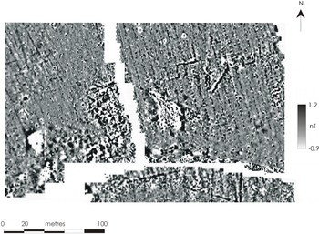
(5) Upton Cresset (SO 647 932): a small-scale evaluative training excavation was carried out as part of on-going research on Wroxeter’s hinterland.Footnote 152 The site had been identified by the landowner in the 1960s and fieldwalking was carried out in the 1960s and 1990s, the last as part of the Wroxeter Hinterland Project.Footnote 153 A geophysical survey revealed that the slight earthworks visible in the field bear no relation to the underlying archaeological features. These earthworks presumably represent the last remnants of substantial field lynchets of post-Roman date which the landowner removed when creating the modern field. The geophysical survey located two parallel ditches 20 m apart and aligned north-west–south-east (fig. 12). Regularly spaced ditches run from these features at regular intervals forming rectilinear plots. Excavation located the substantial ditches, which are thought to be delineating a trackway, and other ditches parallel to the trackway. Pottery was abundant and appeared to date to the late first and second centuries. Substantial quantities of smithing slag and waste were found, the densest concentration being in a pit 1.5 m deep and more than 1 m wide. Further work is envisioned since there is as yet no clear understanding of the character and purpose of the site, but morphologically it appears to be a roadside settlement, as has been suggested from examination of the samian ware from the fieldwalking material.Footnote 154
Upton Cresset. Magnetometer survey of probable roadside settlement.

HEREFORDSHIRE
(1) North-east Herefordshire: two uninscribed Western silver units (‘Dobunnic IJ’) of early first century a.d. date appear to have been part of a scattered hoard of six to eight coins found in the Leominster-Bromyard area.Footnote 155
WORCESTERSHIRE
(1) Dodford with Grafton: three silver and silver-plated denarii, the latest of Hadrian (a.d. 125), found in an area known to have produced other Roman material, including opus signinum, fibulae and other coins.Footnote 156
WARWICKSHIRE
(1) Alcester: (a) former Brooklyn Ford Garage/Waitrose car park (SP 0885 5737): observation revealed the side walls and part of an internal cross-wall of the large stone building, probably a granary, originally discovered in 1979. A possible occupation layer containing pottery and animal bone lay outside the building to the north-west and a separate trench exposed a probable rubble and gravel yard surface. The area is believed to have been marsh in the prehistoric and early Roman periods and two waterlogged samples from immediately over the natural gravel produced Mesolithic period dates, in contrast to an earlier Iron Age determination.Footnote 157 (b) 26 Augustus Drive (SP 0854 5719): a trial trench on the western edge of the extramural area of the Roman town on the line of Ryknild Street, revealed two Roman ditches, one possibly a roadside ditch, and a post-hole.Footnote 158
(2) Great Packington: a silver denarius of Tiberius (mint of Lyon) additional to a previous discovery.Footnote 159 The total now stands at 17 silver denarii from the Republic to Tiberius (a.d. 37).
(3) Sherbourne, M40 Junction 15 improvement (SP 2627 6380): excavation over an area of 27 ha recorded a later Iron Age and Roman agricultural landscape.Footnote 160 To the north of the M40 near Hampton Road a dense pattern of enclosure ditches and gullies covering an area of 4 ha, together with a ring-gully and a few pits, indicated a focus of settlement. Two inhumation burials were found, and a horse skull had been placed in the terminal of an enclosure ditch. To the south of the motorway a small D-shaped enclosure associated with Iron Age and early Roman pottery appeared to contain two or three roundhouses and numerous pits. This site was planned but not further explored. Some 500 m to the south-west of the D-shaped enclosure two late prehistoric trackways and a corner of a double-ditched enclosure of Roman date were found. Cremated human bone was recovered from a pit.
(4) Stockton, School View, School Street (SP 438 638): a trial trench and observation revealed a gully and post-hole, and four parallel ditches, three containing first- to second-century pottery, the fourth third/fourth-century pottery. These were succeeded by medieval gullies.Footnote 161
(5) Stratford-upon-Avon: (a) 77 Tiddington Road (SP 2122 5536): observation on the northern edge of the western cemetery of the Tiddington settlement recorded in 1923–24 revealed part of a single further articulated burial and a sherd of Anglo-Saxon pottery.Footnote 162 (b) 79 Tiddington Road (SP 2122 5536): trial trenches on the western edge of the Roman settlement, just to the north-east of the cemetery recorded in 1923–24, revealed further Romano-British burials extending at least 25 m further northwards. To the north of the burials there was a series of Roman and early Anglo-Saxon boundary gullies along the edge of the 2nd Gravel Terrace.Footnote 163
(6) Warwick, 5 Stratford Road (SP 278 643): excavation within the former graveyard of the medieval western suburban church of St Lawrence revealed two small gullies containing Romano-British tile and pottery beneath the medieval burials, along with residual pottery and a third/fourth-century coin in the graveyard soil.Footnote 164
LEICESTERSHIRE
(1) Cadeby Quarry (SK 4921 3027): following a watching-brief on the final quarry area, an excavation was undertaken.Footnote 165 An Iron Age enclosed settlement, suggested by previous geophysical survey, was revealed. Three sides of a rectangular-shaped ditched enclosure were seen (enclosing c. 1,660 m²), with a substantial south-east-orientated entrance-way, and two sub-rectangular structures within. The pottery indicates a very late Iron Age date. The enclosure was located close to a large linear ditched boundary with scattered features, one with a pottery vessel beneath a quern suggesting structured deposition, while some early Roman features included one lined with kiln bars.
(2) Enderby, land between St John’s/Leicester Lane (SP 5520 9956): an excavation was carried out in advance of the Leicester Park and Ride development at Leicester Lane.Footnote 166 The work focused on excavation of two separate areas (1 and 2) along the eastern boundary of the development area that had been highlighted as having archaeological potential on the basis of prior evaluation. The most striking element of the site was two parallel ditches, running broadly north–south across the excavation area. These were clearly related as they both exhibited the same subtle changes of alignment along their course. Pottery from the eastern ditch suggested that these features originated in the mid to late Iron Age and were probably part of a larger linear monument or trackway. The eastern ditch was eventually abandoned but the western ditch continued to be used after the Roman conquest, potentially becoming integrated into a later settlement with additional gullies extending eastwards beyond the development area dating to the late first to second century a.d. The boundary clearly had territorial importance as five human burials were recorded along its length and a further burial and disarticulated human remains were recorded within the ditch itself. It may still have been important as a territorial marker well into the third century or beyond. A subsequent archaeological watching-brief revealed possible road metalling which may be associated with Fosse Way Roman road.
(3) Great Casterton, 3–8 Main Street (TF 001 089): an evaluation of a potential residential development comprised three machine-excavated trenches within the garden of No. 3, where less disturbed areas would be impacted.Footnote 167 All of the trenches contained archaeologically significant remains, including undisturbed medieval deposits containing redeposited Roman material at depth in Trench 2 and extensive in-situ stone-built structures, one of which was possibly Roman in date, in Trench 3.
(4) Leicester: (a) Red Hill, Loughborough Road (SK 5887 0821): in May 2009 human bones were discovered during the excavation of a wildlife pond on an allotment site at Red Hill, Leicester, close to Birstall. A small-scale excavationFootnote 168 uncovered the remains of two, possibly three, Roman inhumation burials interred after the middle of the third century a.d., with associated pottery vessels and hobnailed footwear. Residual Roman pottery from the excavation suggests activity in the area from the late first century onwards. The burials are likely to form part of a small cemetery associated with a settlement in the near vicinity. The discovery in 1938 of a Roman column drum and capital 200 m away suggests a settlement of some substance, possibly a villa. (b) Land adjacent to Bosworth House, Southgates (SK 583 041): an evaluationFootnote 169 revealed a c. 1.0 m-deep sequence of largely undisturbed early Roman deposits overlying natural sands and dropping sharply away to the north. Previous archaeological interventions in close proximity to the site suggest that this material represents the tail-end of the second-century Roman town rampart. (c) 61 Oxford Street (SK 5865 0391): an evaluation was undertaken within the Roman and medieval south suburb.Footnote 170 This revealed a potential Roman road and evidence of pits and spreads suggesting adjacent roadside settlement. A possible disturbed Roman cremation urn and disarticulated human bone were also recovered.
(5) Lutterworth: five silver denarii to a.d. 161 additional to an earlier find.Footnote 171 The total now stands at ten denarii ranging from Titus to the reign of Antoninus Pius.
(6) Ratby, land at Ferndale Drive (SK 517 060): following an evaluation, a strip, plan and sample excavation revealed a group of pits and a gully of Roman date.Footnote 172
(7) South Kilworth, The Grange, North Road (SP 604 819): a strip, plan and sample exercise undertaken following evaluation work recorded evidence of Roman ditches thought to form part of a field-system.Footnote 173 Pottery of first- to third-century date was associated.
(8) Wigston Magna, Ecob’s Garden Centre, Horsewell Lane (SP 6070 9795): monitoring of groundworks for the construction of new dwellings revealed a Roman ditch located in a previous evaluation.Footnote 174 This contained third- to fourth-century pottery and animal bone.
NORTHAMPTONSHIRE
(1) Little Stanion, Longcroft Road (SP 9005 8719): area strippingFootnote 175 prior to development west of the village of Stanion revealed the truncated surface of a major Roman arterial road (Margary 57a), which once linked Godmanchester to Leicester. The road had previously been traced as far as the north-east corner of Oakley Purlieus Wood; its surface was exposed running a further 220 m south-east, beyond which no clear trace survived. Roadside ditches c. 16 m apart flanked a 6 m-wide roadway with a foundation of coarse angular limestone, fractured ironstone and sand. Deposits were heavily truncated through ploughing, with most of the road metalling lost. The smashed remains of a near-complete second-century flagon were recovered from the roadside ditch, but finds were otherwise sparse. Both ditches contained well-preserved molluscs; the abundance of shade-loving snails suggests that the road ran through a largely wooded area.
PETERBOROUGH
(1) Castor, Peterborough Road (TL 1231 9842): area stripping during building renovation revealed the remains of a substantial Roman building.Footnote 176 Wall lines identifiable from robber trenches defined rooms covering at least 16 m by 7 m and continuing beyond the excavation area to the east and under the extant building to the north. Deposits were severely truncated but fragments of a hypocaust system survived in the southern room with a flue in the south-west corner and a pattern of bases for pilae identifiable on the concrete floor. The remains lie close to the site of a building excavated by E.T. Artis and located on his plan of 1828. The poor nature of survival might suggest that this area had previously been exposed, but if the surviving barns are accurately depicted by Artis then this must represent a separate building range.
(2) Peterborough, Yaxley Broadway (TL 5191 2931): an open area excavation covering approximately one hectare revealed evidence of middle to late Iron Age activity and a late Roman farmstead.Footnote 177 The Iron Age activity consisted of outlying enclosures and field boundaries which may have belonged to a settlement previously excavated to the south-west. In the main, sub-square enclosure was a smaller C-shaped enclosure which may relate to a shelter or structure, along with a partial roundhouse. The Roman farmstead formed part of a larger settlement to the south-west. A ‘ladder’ enclosure system was encountered with many of the ditches being backfilled with dumps of rubbish containing pottery, animal bone, tile and 26 coins, dating mainly to the third and fourth centuries. Six large stone-packed post-holes marked the southern end of an aisled building, possibly a barn. The surrounding ditches contained quantities of stone, which may have come from the aisled building. A rectangular tank, cut into the geology with evidence of wood lining, was also discovered.
CAMBRIDGESHIRE
(1) Cherry Hinton, War Ditches (TL 484 556): an area of the ditch of this enigmatic circular enclosure was examined in advance of opening of the extensively-quarried site as a nature reserve.Footnote 178 The ditch was approximately 6 m wide (although truncated by the quarry along its inner edge) and 4 m deep. Pottery suggests that it was dug during the early Iron Age, but late pre-Roman Iron Age and Conquest period material came from the upper metre of the ditch fills. Quantities of kiln furniture from the Conquest period and two late Iron Age brooches were also recovered.
(2) Ely, Stirling Way, near Witchford (TL 5150 7890): during the late Iron Age a settlement was established on the plateau of a small knoll. A large late Iron Age or early Roman boundary ditch meandered along the top contour of a ridge which ran roughly parallel to and overlooked a strategic stream/drain route flowing from Grunty Fen into West Fen. The role of this ditch may be linked to the name Witchford which derives from ‘the Watch on the Ford’. Three burials lay within a small ditched enclosure close to the boundary. A mid-first-century a.d. cremation burial was placed within a late pre-Roman Iron Age greyware vessel. Two second- or early third-century inhumations were also found. A mature woman had been buried on top of two bone spindle-whorls. The other burial, in a relatively deep grave, was of a woman aged between 26 and 44 with five copper-alloy rings on her left hand, including three on a single finger. Two pots — one a complete Nene Valley folded beaker — were placed nearby within the enclosing ditch.Footnote 179
(3) Impington, Unwins Nursery site (TL 4430 6350): evaluation revealed a number of ditches spanning at least two phases of activity. The earlier phase dated to the late Iron Age to first century a.d. and generally comprised large field boundaries. The second phase was attributed to the mid-first to the mid-second century a.d. and saw the re-establishment of these earlier ditches together with a greater density of ditches at the southern end of the site. These ditches, close to and almost parallel with the current Impington Lane, contained a large quantity of locally produced, sandy coarseware storage and cooking vessels, which may indicate close proximity to settlement. A brooch and a sherd of samian pottery were amongst the other finds from this phase. The earliest occupation found during the subsequent excavation dates to the late Iron Age (c. 100 b.c.) and included a roundhouse. Enclosures and ditches dating to the second and third centuries a.d. were present, with numerous finds again suggesting the proximity of contemporary domestic structures.Footnote 180
(4) Kimbolton, proposed Bicton Windfarm (TL 100 704): features relating to a ?late Iron Age to Roman farmstead and its outlying fields were found.Footnote 181 In one trench, in addition to the large ditches identified by cropmarks, several smaller ditches, pits and a cobbled surface were found which may represent three phases of activity. Moderate quantities of pottery and animal bone were recovered. Secondary deposits of burnt material, and a piece of hearth lining with slag attached imply some localised industrial activity. Extending for a distance of about 150 m beyond and to the north-east of the area of cropmarks, further ditches (possibly field boundaries) were identified associated with occasional Roman pottery.
(5) Over, Plot 5, Over Industrial Estate (TL 3790 6930): Roman features and deposits were located across the development areaFootnote 182 but were concentrated in the northernmost trench where at least two phases of activity were recorded, interrupted by an episode of flooding. Pottery from features in the northern half of the site indicates settlement in the near vicinity. Charred plant remains were found in abundance indicating that primary crop-processing was taking place on the site or very close by.
BEDFORDSHIRE
(1) Kempston Rural (TL 1944 4746): open area excavation was undertakenFootnote 183 in advance of the construction of a pipe line c. 350 m south-east of Bedford Western Bypass Site 5.Footnote 184 A corridor c. 4 m wide was stripped and investigated between Cemetery Road and the River Great Ouse (a distance of c. 350 m). Ditches and small pits containing late Iron Age and Romano-British domestic debris occurred within the western part of the trench. With the exception of quarry pits, which were dug into the edge of the gravel terrace, no focus of activity could be identified. The quarry pits were overlaid by a cambered road c. 5 m wide believed to be Roman in origin. Some of the ditches were substantial and, like the road, were clearly part of the Romano-British settlement identified to the north.Footnote 185 On the basis of the recent and previous investigations and non-intrusive survey, the overall extent of the settlement is now known to be over 18 ha.
HERTFORDSHIRE
(1) Baldock, Baldock station (TQ 24576 34576): four evaluation trenches were excavated in the sloped, wooded area opposite the station.Footnote 186 The chalk natural was shown to slope downwards from east to west, in line with the present-day topography. A trench in the eastern half of the site exposed a substantial but undated linear feature which extended the length of the trench. This was cut by three later features, including a V-shaped, east–west-aligned linear one which contained two Roman coins: one dating to c. a.d. 315–320, the other to c. a.d. 340–350. Another Roman coin was recovered from a shallow, irregular feature which also cut the earlier north–south ditch. A third linear feature cut the north–south ditch in the southern end of the trench; its fill contained a pottery assemblage which included a sherd of terra rubra, dating to the Conquest period. Upslope, in the eastern part of the site, another trench exposed two inter-cutting, east–west-aligned ditches, one of which is likely to be a continuation of the ditch in the previous trench. They were sealed by a general dump layer dated to the later Roman period.
BUCKINGHAMSHIRE
(1) Aylesbury, Fleet Marston (SP 7751 1645): an evaluationFootnote 187 revealed evidence of a Romano-British settlement, including both circular and rectangular enclosures, boundary ditches, two potentially revetted ditches or beamslots forming part of a Roman track or building, and a gravel spread probably associated with a north–south Roman road identified during previous excavation in the vicinity of the site. The archaeological remains were sited to the north of a small Roman town located on a crossroad of Akeman Street and the north–south road that runs through the site, suggesting that the settlement was peripheral to the town. Overall, the pottery assemblage recovered on site seems to suggest a relatively low-status community.
(2) Denham, The Lea (TQ 0490 8600): a further phase of excavation in advance of gravel extraction revealed the eastern part of an enclosure which probably dates to the first to second centuries a.d. The only internal features were two probable wells in the south-west corner.Footnote 188
(3) Dinton, Cuddington Road, Marsh Mead Farm (SP 7578 1157): an evaluation consisting of five trenches revealed several Roman field ditches dating to the second century or later. A pit or ditch terminal also recorded may be of middle Iron Age date.Footnote 189
(4) Hambleden, Yewden Lodge Villa, Horseleys Field (SU 784 855): a fluxgate-magnetometer survey was carried outFootnote 190 in the environs of the scheduled villa site at Yewden Lodge, which was substantially excavated in the early years of the twentieth century.Footnote 191 The geophysical survey was targeted on a pasture field (Horseleys) directly east of the field containing the Yewden villa where outlying elements of the main villa complex in the form of enclosures, trackways and a possible Romano-British temple or shrine are indicated on aerial photographs adjacent to the former course of the Hamble Brook. The survey identified several ditched enclosures with adjoining trackways. Some contained internal positive anomalies possibly indicative of large pits, quarries or industrial features.
MILTON KEYNES
(1) Brooklands (SP 910 397): open-area excavations were targeted on five areas previously revealed by trial trenching and geophysical survey to be rich in archaeological features.Footnote 192 Areas 6 and 8, which were adjacent but separated by a modern road, produced evidence for middle Iron Age settlement. This was overlain by a late Iron Age to early Roman ditched enclosure and trackway, which probably linked the site to the major Iron Age and Roman settlement at Broughton Manor Farm, just a few hundred metres to the west. Activity at Area 7 comprised a middle to late Roman enclosure (probably established between the mid and late second century), along with a north–south trackway and a number of smaller enclosures, possibly used as animal pens, and a scatter of pits. The upper fills of the enclosure ditch produced a mixed assemblage of late Roman and early Anglo-Saxon pottery, suggesting possible continuity of occupation into the fifth and sixth centuries.
OXFORDSHIRE
(1) Abingdon, Abingdon Museum (SU 4979 9705): pits or post-holes were recorded within two test-pits to the south of the museum. Though undated, they were overlain by a sequence of metalled Roman road surfaces. The earlier sequence of surfaces suggests that the road was generally well maintained with periodic resurfacing. In contrast, the latest surfaces were crudely repaired with cobbles and pebbles, representing the road’s disuse in the late Roman and early Saxon periods. A gully dated to the late third or fourth century was possibly a drainage feature, suggesting that the road was aligned north-west to south-east. The bases of pits, dated by pottery to the first or second century, were recorded.Footnote 193
(2) Beckley, Thames Water pipeline and new STW (SP 56201150–56411167 & 56601150–56561190): a watching-brief was undertaken as part of the works for a new sewerage system for the village.Footnote 194 A number of archaeological features were uncovered including sections of a Roman road.
(3) Dorchester-on-Thames, allotments (SU 577 941): the focus of the 2009 investigation was the late Roman to early post-Roman sequence adjacent to and above the principal north–south Roman road through the town.Footnote 195 The road and associated surfaces were cut by a number of pits, and the road was also cut by a row of post-holes, suggesting that a structure had been placed on the metalled surface. Most of the pits have yet to be examined, but a late Roman or even later date seems likely. Some of them related to a sequence of dark earth deposits which originally covered most of the site. These deposits were particularly substantial in the central area of the site, where successive spreads of stone within them (including a possible building-platform identified in 2008) indicate that they accumulated over an extended period. Removal of the dark earths in the north-western part of the site, where they were thinner, revealed mixed gravel deposits, again cut by pits in places. One well-defined sub-rectangular patch of gravel possibly formed the floor of a building. The dark earths also sealed features identified in earlier excavations by Professor Frere as wall trenches for a Saxon building. Re-examination showed that these features were very different in character — one a shallow slot, the other a substantial steep-sided ditch. It is possible that the latter was of Roman date, with Saxon material from the upper fills.
The finds include an important late Roman pottery assemblage, and early Saxon pottery was also recovered, along with two ring-shaped loomweight fragments. The most significant individual object was a second late Roman buckle of Hawkes type IB (an unstratified example was found in 2008) from one of the components of the dark earth deposits. The recovery of two of these buckles from a small excavation area is notable and underlines the importance of Dorchester for the understanding of events at the very end of the Roman period in Britain. An enigmatic object found in 2008 proved to be a fine copper-alloy Medusa head mount, probably of third- or fourth-century date. This seems to have been reused as it is backed with a very substantial lump of lead, originally contained within thin copper-alloy sheeting. The function of this apparently composite object remains obscure.
(4) Headington, Warneford Hospital (SP 538 059): a ditch containing pottery of a broad Roman date and a post-hole were recorded.Footnote 196
(5) Souldern, High Street, Manor Farm (SP 5207 3165): a watching-brief was conducted during groundworks for a new development.Footnote 197 A ‘Belgic’ urn containing a cremation burial was found.
(6) Stanford in the Vale, sewer pipeline (SU 3426 9294–SU 3473 9358): a watching-brief during the construction of a 1 km-long pipeline to the south-east of Stanford in the Vale recorded two pits containing the cremated remains of adult humans. These might be associated with the small settlement previously identified at Stanford in the Vale.Footnote 198
(7) Swinbrook, South Lawn Farm (SP 2879 1460): a watching-brief revealed four gullies, two ditches, two further possible ditches, and two post-holes. Two phases of activity were identified but all the features contained pottery dated to the first century a.d.Footnote 199
6. EAST ANGLIA
NORFOLK
(1) Attleborough: four silver/base silver denarii and one base silver radiate to a.d. 217.Footnote 200
(2) Brancaster, Marsh Lane (TF 7792 4417): construction work was monitored on a site immediately west of the Scheduled area of the Roman fort of Branodunum and vicus and north of the settlement area outside of the fort excavated in 1974–77.Footnote 201 A number of slight ditches crossed the area, only one of which yielded Roman pottery. However, the early to mid-second-century date range for occupation suggested by the pottery is significant as previous work had indicated that occupation of the fort and vicus complex commenced only in the late second century.
(3) Dereham: 44 silver/base-silver denarii and 1 base-silver radiate, addenda to a large hoard of over 1,000 coins discovered by the same finders from 2004.Footnote 202 The latest coin in the addenda (and latest overall so far) is a denarius of Gordian III, a.d. 241 (RIC 129).
(4) Near Kings Lynn: a clipped silver siliqua of Valentinian II (RIC IX, 43 or 57, a.d. 375–83), drilled with a central hole, transforming it into a pendant or, more probably, a mount.Footnote 203
(5) Swanton Morley: 24 copper-alloy nummi to a.d. 353, scattered over a confined area from which other coins were also recovered.Footnote 204 The 24 coins, all large copper-alloy nummi of Constantius II, Constans and Magnentius, were recognized as being from a dispersed hoard.
SUFFOLK
(1) Capel St Mary, Days Road (TM/08 38; CSM 030): trenching and open area excavation was undertaken at a c. 1.2 ha site to the north of Capel St Mary in advance of housing development.Footnote 205 The site produced the remains of part of an enclosed settlement dated broadly to the Iron Age, and a large number of medieval features, including structures, ditches, pits and probable quarry pits. In addition, evidence of smaller scale activity of Bronze Age and Roman date was also encountered. A rectangular post-built structure associated with mid-first- to second-century pottery represents a relatively low-key Roman presence in the south of the site. A number of ditches yielding pottery suggest the presence of a Roman field-system.
(2) Eye: (a) new MUGA pitch, Hartismere High School (TM 1374 7410; EYE 094): evaluation on part of the playing field at Hartismere High School in advance of the development of a new sports pitch identified a spread of features relating to Roman activity.Footnote 206 The finds assemblage included Roman pottery of early and late date, a range of metal finds, chiefly late Roman coins, and ceramic building material. This activity relates to an adjacent site where full excavation revealed mainly early Anglo-Saxon activity with very late Roman finds. (b) A base gold stater, a gold quarter stater, 28 silver units, two copper-alloy units and a Roman copper-alloy as constitute additions to a previously known hoard of mid-first-century a.d. date.Footnote 207
(3) Hoxne: fragments of seven clipped siliquae found in September 2009Footnote 208 are further additions to the well-known hoard of a.d. 408.Footnote 209
(4) Mildenhall: (a) Smoke House Inn, Beck Row (TL 68947787; MNL 618): evaluation in advance of housing development identified substantial and well-preserved evidence of Roman occupation across an area of up to 3 ha, an extension to deposits previously identified at a series of adjacent excavations. Occupation appears to begin in the second century and continued through to the end of the Roman period.Footnote 210 The density of deposits and presence of a preserved Roman soil horizon through many of the trenches indicate a focus of domestic activity, supported by a sizeable finds assemblage which includes a copper-alloy statuette and a copper-alloy bowl. (b) Land off Recreation Way (TL 7132 7455, MNL 622): evaluation identified middle to late Iron Age and Roman quarry pits and drainage ditches. One pit contained a single possible early to middle Anglo-Saxon sherd.Footnote 211
(5) North Suffolk: a hoard of 206 silver denarii to a.d. 82/3.Footnote 212 Notable pieces include a coin of Juba I (60–46 b.c.) and a denarius of M. Plaetorius Cestianus (RRC 409/2). The double-headed axe on the reverse is not listed in RRC as a control mark. Two denarii of Vitellius are variants not listed in RIC and a hybrid coin with an obverse of Vitellius, apparently of the Lugdunum mint, has a reverse type of the Rome mint of Vespasian.
(6) Near Woodbridge: a hoard of 14 denarii.Footnote 213 The latest closely dated coin in the hoard is for Marcus Aurelius in a.d. 171–172, although an undated (but lifetime) coin of Faustina II could have been issued as late as a.d. 176.
ESSEX
(1) Billericay area: a Byzantine gold solidus of Anastasius (a.d. 491–518), adapted into a pendant.Footnote 214 The suspension loop, formed from a ribbed strip of gold, is attached at 12 o’clock on the obverse, and 6 o’clock on the reverse.
(2) Colchester (Camulodunum): (a) Goojerat Barracks (TL 9894 2418): trenching in the northern part of Goojerat Barracks, immediately north of the area examined last year,Footnote 215 revealed undated ditches which may be Roman in date because they shared the orientation of a Roman field-system found elsewhere at the Garrison.Footnote 216 (b) Land adjacent to 9 Walters Yard (TL 9955 2537): this site is on the eastern side of Insula 11 of the Roman town. A medieval robber trench marked the position of the wall of a Roman building which stood in the north-eastern quarter of the insula, and an adjacent fragment of compacted clay represented the floor of a Roman building probably pre-dating the robbed wall.Footnote 217 (c) East Hill House, 78 High Street (TM 00852 25227): this site lies in Insula 31/32 of the Roman town. Prior to the refurbishment of East Hill House, three trenches revealed parts of two Roman buildings, presumably town-houses, one of which had a hypocaust, and the other at least one area of tessellated pavement.Footnote 218 (d) Roman town wall at Roman Road (TM 00177 25385): two trial-trenches excavated as part of a conservation strategy outside the upstanding parts of the eastern side of the Roman town wall (a scheduled ancient monument) confirmed that even where the wall has been robbed and replaced with later material, original parts survive in situ below ground.Footnote 219 (e) Colnebank House, 30 St Peter’s Street (TL 9651 5590): evaluation of this site, lying 40 m north of the north wall of the Roman town, and on the south bank of the River Colne, exposed river gravels containing Roman brick debris at 2.1–2.5 m below current site level.Footnote 220
(3) Great Chesterford: three denarii, the latest of Faustina II (up to a.d. 176).Footnote 221
(4) Great Dunmow: (a) 2 Chequers Lane (TL 6247 2194): an evaluation on the northern edge of the Roman small town revealed a compacted gravel surface which is the northerly continuation of a Roman gravel road identified in the 1970s.Footnote 222 Subsequent monitoring revealed further areas of Roman gravel road, and Roman pits.Footnote 223 (b) Salerooms, Chequers Lane (TL 6265 2189): this site is immediately east of the 1970s excavation site and approximately 100 m south-east of the site at 2 Chequers Lane. A trial-trench and excavationFootnote 224 revealed a thick deposit of gravel bounded by a ditch on its southern side. Given its position and alignment, this must be the continuation of an east–west Roman road whose course was indicated by road-side ditch alignments on the 1970s site. Twenty-three Roman inhumation burials were clustered on the north edge of the site (the Chequers Lane frontage). No human bone survived, but a number of the graves contained hobnails and pots (often fragmentary). In contrast to the 1970s site, there were no cremation burials. A number of small features may have been post-holes containing grave markers. A semi-circular feature cut some of the graves. It is uncertain whether this was a ring-ditch around a grave, or (given the shrine on the adjacent 1970s site) of ritual origin.
(5) Kelvedon, 193 High Street (TL 8631 1913): an area excavationFootnote 225 close to the Roman small town at Kelvedon revealed a Roman pit and ditch. These may represent activity alongside the Colchester–Kelvedon Roman road (now the modern High Street) which runs 50 m to the south.
(6) M25 widening: (a) Hobbs Hole, M25 Junction 29 (TQ 589 884): formal land division relating to the Roman period was recorded, although this was relatively poorly defined. Waterholes and possible clay quarries were associated with this landscape. (b) Stapleford Tawney, Passingford bund (TQ 5077 9764): the edge of a possible small settlement was encountered within the eastern end of the strip, map and record excavation area. Part of the ring-gully of a circular structure and associated pits were excavated. These were enclosed by ditches and pits. Pottery suggests a second- to third-century date. (c) Stapleford Tawney, Passingford flood alleviation area (TQ 5152 9750): a late Iron Age settlement of four or five circular structures represented by entrance post-holes within a surrounding penannular gully was recorded, along with associated curvilinear enclosures, pits, waterholes and quarries. Pottery suggests that occupation continued into the late first century a.d. (d) Theydon Garnon, Pond 1609 (TQ 4794 9951): several small and shallow pits containing charcoal and occasional Roman pottery sherds were recorded.Footnote 226
(7) Sandon, Chelmsford Park & Ride site (TL 744 055): area excavation revealed a Roman-period sub-circular enclosure (40 m in diameter) to the south of a Bronze Age ring-ditch.Footnote 227
(8) Stanford-le-Hope, London Gateway Compensation Site A, Wharf Road (TQ 698 811): excavationFootnote 228 revealed two areas (A and B) of early Roman salt extraction located adjacent to large creeks. There is very little evidence for domestic occupation in the early Roman period; pottery and other artefact assemblages are notably sparse, particularly when compared with the artefact-rich late Roman sequence. The early Roman evaporation hearths survived as shallow oval or sub-rectangular scoops. Clay-lined pits, interpreted as settling tanks and present in both Areas A and B, consisted of long troughs lined with clay, sub-divided by clay walls to form rows of three tanks. The two salterns appear to have been organised differently: Area B had four hearths and two rows of settling tanks, clustered in a tight group in one corner of the saltern mound and with no sign of associated buildings or shelters. In Area A, traces of low mounds or ‘red hills’ formed a slight ridge along the north edge of the area. The surviving hearths were more dispersed and mostly found in association with built structures. One hearth and a single row of settling tanks were found inside a large roundhouse (dated by pottery to the later second or early third century). Wooden structures from the site include a pair of channel revetments made of wattlework, a possible footbridge made from piled oak timbers and found within a channel alongside the Area B saltern mound, and a U-shaped timber structure in Area A, interpreted as a boathouse, radiocarbon dated to the first or early second century. One of the more unusual features of the site is a probable saltern dating to the late third or fourth century. This appears to have used a substantially different process and was probably organised differently from the early Roman salterns. A large, robust hearth of this phase survived almost intact; it formed a low circular structure built from two courses of tile, with three raised pillars surviving to three courses. Lumps of fired clay with white residues suggest that salt evaporation is the most likely function of this hearth. The late Roman area also included a very unusual building with a circular clay floor, c. 15 m in diameter, surrounded by a shallow gully. The structure was supported by a square arrangement of four massive posts built on post-pads of chalk and flint rubble, set in the base of square pits. Masses of pottery were found in association with the late Roman sequence, concentrated in an extensive midden.
(9) Tendring district: nine copper-alloy nummi to a.d. 355, all fragmentary.Footnote 229
(10) Uttlesford II: a hoard of five gold solidi, 12 silver siliquae and a copper-alloy nummus to c. a.d. 406. A gold ring was also associated.Footnote 230
(11) Wendens Ambo, Duck Street and Rookery Lane (TL 510 361): pits and shallow ditches of the third to fourth century indicate agricultural activity on the site which appears to be peripheral to the major Roman villa complex to the NNW at Chinnel Barn.Footnote 231
(12) Wickham Bishops, Thistle Hall, Mope Lane (TL 834 126): records of previous discoveries on Wickham Bishops Hill include late Iron Age burials and late Iron Age settlement found in 1916 during the digging of WWI military training trenches. An evaluation identified two Roman urned cremation burials.Footnote 232 The site should therefore now be considered to be Iron Age and Roman.
7. GREATER LONDON
GREATER LONDON
(1) ‘Upper Thames’: a ‘Flat linear I’ potin dated to the mid-first century b.c. found on the Thames foreshore is an addendum to the earlier hoard of 16 potins found at the same location in 2008.Footnote 233
CITY OF LONDON
(1) Bread Street dropshafts, EC4 (TQ 32315 81170): the excavation of three dropshafts was monitored.Footnote 234 These were located in the northern part of Bread Street between the junctions with Cheapside and Watling Street. In the central section of the street on the west side, dumped deposits containing Roman pottery were cut by part of a Roman or medieval chalk wall. Adjacent to this on the east side of the street, a sequence of Roman dumping (containing pottery and building material) was sealed by deposits containing medieval pottery. Among the Roman dumped deposits was a small palette, used for the grinding of cosmetics or medicaments. It was finely cut, unusually small (39.8 by 25.1 by 9.9 mm), and made from imported white marble (fig. 13) The majority of palettes found in London have been made of fine-grained stone, shale, or Purbeck marble, although two other marble examples have been found at No. 1 Poultry (ONE94) and Gresham Street (GHT00).
Bread Street dropshafts, London EC4, marble palette, length 39.8 mm. (Photo: A. Chopping; © Museum of London Archaeology)

(2) Cannon Place, EC4 (TQ 32620 80850): Cannon Place is the site-name for Cannon Street railway station. Archaeological investigationsFootnote 235 are taking place in tandem with demolition/refurbishment of the site. The excavation/watching-brief recommenced in January 2009, following on from work carried out in December 2007 and throughout 2008.Footnote 236 The site forms part of the Scheduled Ancient Monument known as the ‘Roman Governor’s Palace’. Work in 2009 focused on an area immediately adjacent to, but just outside the west limit of the Scheduled Ancient Monument along the Dowgate Hill street frontage. A series of vertical king-posts had previously been piled along the edge of the viaduct to facilitate insertion of a new basement wall. As the wall was constructed, a narrow strip of archaeological material c. 18 m in length by c. 0.50 m wide was exposed and recorded. Limited evidence for pre-Palace structures (pre-a.d. 69) included a small fragment of mortar floor and a well-preserved opus signinum floor. Non-structural features/deposits included sequences of dump layers/trample and rubbish-pitting. A substantial building sequence developed along the length of the strip in the early to mid-second century (a.d. 120–160). Structural features included ragstone/chalk foundations, ragstone walls, mortar floors/surfaces and a small fragment of rendered flint/tile wall with tessellated floor. Evidence for later Roman activity was limited to a 0.6 m-thick ‘organic’ clay-silt deposit (dated a.d. 350–400), probably a dump layer or garden soil rather than abandonment ‘dark earth’.
(3) Crosby Square (The Pinnacle), EC2 (TQ 33135 81239): a first phase of excavation was carried out to the west and south of the secant wall trench excavated during 2008. Natural brickearth was cut by pits with sterile fills, probably representing quarries. Sealing these in the east and south were fragmented remains of Roman clay-and-timber buildings, one of which had a plain red tessellated floor. In the north-west of the excavated area running north–south was a Roman masonry drain built in re-used roof tiles. These were sealed by thick dumps of redeposited brickearth containing fragments of painted wall-plaster. Mainly in the south and east of the area, the Roman building remains had been cut into by a series of pits of either late Roman or medieval date (pending dating). A watching-brief revealed only modern material. A second phase of excavation was carried out in the remaining small triangle in the north-east corner of Crosby Square after the insertion of the Martello piles. Natural brickearth was cut by a series of shallow features, which were probably quarries, and one possible grave. No human remains were found in this feature and it is possible that these were relocated when the early Roman settlement expanded into this area. Over these cuts were the robbed foundations of a Roman masonry building. At least two rooms associated with this building were found, all with earth floors. Cutting east–west across the remains of this building was a Roman masonry drain (a wider return to the one found in the first excavation phase). These remains were again sealed by thick wall-plaster-rich dumps and medieval features.Footnote 237
(4) 20 Fenchurch Street, EC3 (TQ 3308 8088): the majority of the deposits excavated on the site dated to the Roman period.Footnote 238 At the earliest levels a series of structural features were cut into the natural sand and gravel. In the southern and eastern areas of the site linear cuts complemented by a pattern of post- and stake-holes were recorded. They possibly represent early Roman occupation prior to the Boudiccan fire. Also at this level was a timber-lined drain in the base of a linear cut running east–west through the west area of the site. Sealing these was a layer of burning, identified more or less across the site, averaging approximately 100 mm thick and tentatively identified as Boudiccan fire deposits. Directly above this layer were a number of features which could possibly be linked to the suspected fort, identified on an earlier excavation on the nearby site of Plantation Place. In the eastern Rood Lane area of excavation a hastily laid and temporarily used road, on a north–south alignment, was recorded. To the east of this was a large ‘oven’ feature, too large to be for domestic use, which may have been linked to the provision for troops.
Above these phases an abundance of clay-and-timber building remains and other probably domestic occupation deposits was excavated. It was not always possible to deduce their extent or alignment due to the fragmentary nature of the evidence, but a general Roman alignment, different from that of the modern street, can be seen. Cutting through these deposits, three sides of a large ragstone cellar were observed. The walls measured approximately 0.83 m wide and survived to a depth of 0.88 m. The stone blocks in this construction were substantial and indicate that they formed the foundations of a multi-storied building on the site. Within this basement structure was a relatively thin partition wall running north–south. A series of brickearth floors abutted this wall at the base, then at a later date the wall was evidently removed to a low level and several floor layers were recorded covering these remains, presumably filling the now open basement area.
Other late features include a line of substantial post-holes representing a building adjacent to the cellar to the west. A square well was discovered nearby. In 10 Rood Lane there were also late Roman ragstone foundations running both north–south and east–west which appeared to consist of at least two phases of construction. Roman industry was represented by a hearth sequence and burnt deposits with possible metalworking associations in the north-west corner of the site. In the western area of the site was a pit with traces of lime still remaining in the base.
(5) Gresham Street dropshafts, corner of Gresham Street and Milk Street (outside No. 2 Gresham Street), EC1 (TQ 32393 81336): four dropshafts were monitored.Footnote 239 In one, a north–south-aligned ragstone wall with a chalk foundation of Roman or medieval date was observed.
(6) Shield House, 16 New Street, EC2 (TQ 3580 8152): following work in 2007, a watching-brief took place within the Grade II Listed eighteenth-century East India Company warehouse.Footnote 240 No evidence was seen for Roman quarries which were suggested in a 2003 evaluation (under the site code NEE02) which was limited by the small size of the trial pits.
(7) Copthall Avenue, EC2 (TQ 3279 8137): excavationFootnote 241 continued from 2006 revealing late first- to early second-century levelling layers, cut by a light timber revetment which supported the south bank of a ditch or stream channel. Sealing these features were possible occupational horizons, domestic waste pits and dumped deposits. A second phase of revetting was revealed, together with an adjacent series of timber piles, which may form the foundation of a wall of early third-century date. A series of third- to fourth-century dumped deposits sealed the features.
(8) Lovat Lane, EC3 (TQ 3306 8078): excavation uncovered two possible pits or wells, and a series of brickearth floor slabs, possibly representing the internal floors of a clay-and-timber building of first- to second-century date.Footnote 242
(9) Queen Street dropshafts, EC4 (TQ 32435 80914): excavation of dropshaft positions and a drainage gully in the southern part of Queen Street was monitored.Footnote 243 A sequence of Roman and medieval dumped layers containing pottery and building material was recorded beneath modern material and services.
(10) Rothschild Building, 1–10 St Swithin’s Lane, EC4 (TQ 3270 8100): a Roman pit or well was observed in section during the removal of the existing basement wall. All other remains had been truncated by the later building.Footnote 244
(11) Colchester House, Savage Gardens and Pepys Street, Coopers Row: a hoard of 134 nummi and a lead disc deposited in the a.d. 350s were found with a largely intact late Roman coarseware jar in the upper fills of a well associated with a large masonry structure of late fourth-century date.Footnote 245
BEXLEY
(1) John Newton Court, Welling, DA16 (TQ 46920 75620): five cut features were recorded at the eastern end of the site during evaluation, most being shallow and of uncertain purpose.Footnote 246 Pottery of first- to second-century date was recovered from three of these. One feature was identified as a possible linear ditch on a north–south alignment, with some evidence of recutting. A cremation burial had been cut into the edge of the ditch. These features probably form part of a long-term Roman settlement, possibly the continuation of a Roman settlement recorded by Kent Archaeological Rescue Unit in their 1989 excavation (site code KEWW89) carried out some 70 m to the north-east of the site. A subsequent watching-brief revealed no further Roman features.
(2) Embassy Court, High Street, Welling, DA16 (TQ 46681 75723): excavations revealed an untruncated sequence of remains related to settlement along the Roman road of Watling Street, now known as High Street.Footnote 247 These consisted of a series of ditches, some of them running parallel to the High Street, various post-holes and beamslots that may have been part of buildings, and a number of rubbish pits. Various cremation urns and grave cuts, possibly timber-lined and containing decayed fragments of human bone, were recorded in the east of the site, separated from the settlement area by a ditch, suggesting that this area was set aside for burials.
BROMLEY
(1) H. Smith Yard, Bellefield Road, Fordcroft (TQ 4668 6757): excavations continued within the area of Bellefield Road, designated as a Scheduled Ancient Monument Roman Bath House and Saxon Cemetery (SAM 145).Footnote 248 Evidence of Roman activity comprised a tile and flint foundation, possibly representing the back wall of the western room of the bath-house, a ditch, most likely the continuation of the Roman ditch uncovered during the 1960s excavations, and a number of layers and/or pit fills of probable Roman date.
CROYDON
(1) Riddlesdown Common, Purley (TQ 32404 60636–TQ 33466 59598): a watching-brief was carried out on a 1.5 km length of a proposed new cable trench between Purley grid substation and Caterham.Footnote 249 Although the ‘Newe Ditch’, a feature of possible prehistoric or Roman date, was located near the route of the cable trench, no archaeological remains were observed.
HACKNEY
(1) Holywell Priory, Holywell Lane, Shoreditch, EC2 (TQ 33436 82342): a watching-brief was carried out on a series of test pits and interconnecting drain-runs in Holywell Yard and King John’s Court.Footnote 250 A few residual sherds of Roman pottery were recovered but no structural remains were observed. The area probably remained as open ground during the Roman period.
(2) 87–95 Curtain Road, Shoreditch, EC2 (TQ 3325 8244): excavation revealed a large Roman pit, containing a high concentration of building material, sealed by a layer of possible Roman agricultural soil.Footnote 251
HAVERING
(1) 105–109 New Road, Rainham, RM13 (TQ 50870 82917): an evaluation, watching-brief and excavation were undertaken.Footnote 252 In the southern part of the excavation area, natural gravels were cut by an east–west-aligned recut ditch of late Roman date.
(2) South Street, Lowen Street, Lower Mardyke Avenue, Roman Close, Mardyke Estate [Blocks B, L & P], Rainham, RM13 (TQ 5057 8339): excavations carried out prior to the demolition of the 1960s estate revealed a number of features representing three phases of Roman activity.Footnote 253 The initial phase comprised a curvilinear ditch which dated from the mid to late first century a.d. A linear ditch, with associated pitting and post-holes, bisected the curvilinear ditch and represented a second phase of activity during the late first century. The final phase, dating from the late first to mid-second century, included numerous intercutting pits, which truncated the linear ditch. All features encountered were indicative of settlement and were sealed by an extensive deposit of twentieth-century rubble.
LAMBETH
(1) Mary Seacole House, 91 Clapham High Street, SW4 (TQ 29775 75440): three evaluation trenches were excavated, but no evidence was found for Stane Street (Margary 15) which is known to run through this area of Clapham.Footnote 254
LEWISHAM
(1) Honor Oak Park Sports Ground, Brockley Rise, SE4 (TQ 36505 74248): an evaluation in 2008 had found areas of gravel metalling, presumed to be part of a Roman road, in three trenches on the west side of the sports ground. During the 1930s, it was sectioned in a number of places between West Wickham and Peckham by DavisFootnote 255 and its course projected between these observations. A watching-briefFootnote 256 confirmed the projected route of the road, crossing the western part of the site, and gravel surfaces found these were at a similar level to those recorded by Davis, although they have been subject to truncation by the levelling of the area for sports pitches. A dupondius of Domitian (a.d. 81–96) was found at the south-east end of the road, but no other Roman finds were recovered. The road showed evidence of being severely truncated, leaving only the lower sandy bedding material of the road’s make-up at the south-east end and a harder, more solid gravel surface at the north-west end. In the centre of the watching-brief area the road had been disturbed by the construction of a modern sports pavilion. The construction of the sports ground in the 1950s had resulted in the total removal of the southern extent of the road, though it may survive under a raised area at the extreme southern end of the sports ground. The surviving road make-up has been preserved in situ.
NEWHAM
(1) Abbey Road DLR Station, Abbey Road, Stratford, E15 (TQ 39080 83410): a single pit, possibly of Roman date, produced a combed flue-tile. Roman activity was also indicated by residual fragments of building material and seven abraded pottery sherds.Footnote 257
SOUTHWARK
(1) New London Bridge House, 25 London Bridge Street, SE1 (TQ 32820 80230): four evaluation pits were excavated.Footnote 258 In the western part of the site, there was evidence for a second-century Roman masonry building with at least one room heated with a hypocaust. These remains included two east–west-aligned ragstone and tile walls, a mortar floor, and three tile stacks (pilae). The area of the hypocaust and one of the walls was infilled with a series of demolition deposits which included mortar fragments and occasional fragments of tesserae. Demolition layers near the other wall were overlaid by ‘dark earth’ deposits.
(2) St Michael’s Catholic School, John Felton Road, Bermondsey, SE16 (TQ 24225 79669): following work in 2008, two areas on the east side of the playground were identified for further excavation.Footnote 259 Natural sand and gravels were overlain by a soil horizon of Roman date. Towards the south of the site, several first- to second-century quarry pits were recorded, sealed by a further soil horizon containing significant quantities of Roman pottery dated to the first- to third-centuries. A large channel backfilled with Roman deposits was located running NE–SW towards the River Thames. Significant quantities of residual pottery of late Bronze Age to late Iron Age date were also retrieved from Roman deposits.
(3) Tate Modern, Bankside, SE1 (TQ 31925 80390): a borehole to the north-west of the Tate Modern located Roman building material (dated a.d. 50–160) within deposits immediately overlying natural gravel. Borehole profiles provided evidence for a rise in ground level towards an eyot located to the south-west of the site.Footnote 260
(4) Abbey Street, SE16 (TQ 3376 7940): an evaluation uncovered a Roman ditch with associated stake-holes. The fill of the ditch contained a high percentage of both iron-smithing and smelting waste, which suggests that industrial activity was taking place in the vicinity of the site.Footnote 261
(5) Bermondsey Square, SE1 (TQ 3328 7933): an excavation recorded a series of Roman pits underneath a layer of Saxon agricultural soil.Footnote 262
(6) Igloo Regeneration, Bermondsey Square, Island Site, SE1 (TQ 3330 7930): excavation continued at the site of the Scheduled Ancient Monument of Bermondsey Abbey.Footnote 263 This phase of work was to the east of the previously excavated area, on a small parcel of land known as The Island, and revealed a series of early to late Roman pits and ditches.
(7) 28–30 Trinity Street, SE1 (TQ 3245 7940): excavations carried out between 2007 and 2009 uncovered a number of third- to fifth-century inhumation burials, cremation burials, and a sequence of late first- to early fifth-century ditches.Footnote 264 The site is situated to the south of the Roman suburb of Southwark and was thought to lie on the margins of the cemetery area previously investigated at 165 Great Dover Street. Although some areas were devoid of burials, which in part reflected the severe truncation caused by modern basements, inhumations were discovered on or close to the site boundaries on the north, west and east sides, demonstrating that the cemetery extended beyond the limits of the site. A total of 44 inhumation burials and two cremation burials in urns, one of which was found with an inhumation, were recorded. The inhumation cemetery might have been established in the very late second century but the vast majority of the burials dated to the third and fourth centuries. Coins recovered from the graves or associated soil horizons demonstrated that some of the burials are among the latest Roman graves excavated in London as they were associated with coins dated a.d. 388–402. These burials may well have dated to the early fifth century. A sequence of ditch systems dating from late first or early second century through to the late fourth to early fifth century covered most of the excavated area, although none of the ditches remained in use throughout the entire Roman period. An early focus dated to the late first or early second century was identified in the southern part of the site. The early ditch system enclosed what may have been a large colonnaded timber structure built on substantial timber beam foundations. These features are located close to a previously known early Roman inhumation, found at Harper Road, dated a.d. 50–70. Although the number of graves was relatively small, many forms of burial common to late Roman cemeteries were evident. Some graves had been furnished with coffins, evident as nails or other fittings, and three plaster burials were recorded. No single grave orientation predominated and examples of north–south and east–west aligned burials were found superimposed on each other. It is probable that the cemetery was divided into areas by enclosures. Although no actual trace of these structures was evident some areas of the cemetery were devoid of burials whilst others were densely occupied. Spoil was systematically metal-detected and this resulted in the recovery of around 150 coins, mostly of late Roman date. These have given a very good insight into the periods in which the site was being utilised and highlighted the fact that Romanised life appears to have continued on the southern margins of Londinium until the last years of the fourth century and very probably the early fifth century, a view previously highlighted by excavations at Tabard Square.
(8) Thameslink 2000: Borough Viaduct, SE1 – Hop Exchange Viaduct, Pile Caps H1-J (TQ 32584 80194): the earliest Roman evidence consisted of an east–west-aligned ditch which had truncated a north–south-aligned palisade trench comprising pairs of stake-holes placed within a ditch with a pair of larger supporting post-holes. At the eastern end of the trench was a building formed by driven post-piles, represented by a series of closely grouped post-holes. This had a possible entrance along the north side, suggested by the lack of post-holes in this location and a much larger post-hole on the west side. This area was heavily slumped and later filled with sand. Within the building a rare complete copper-alloy oil lamp was recovered. To the east, a furnace or burnt post structure was uncovered, comprising four post-holes and a linear cut containing burnt wood and charcoal. Gravel and sand surfaces for a possible external yard or workshop area produced a number of sherds of samian ware with graffiti such as an ‘X’ incised on the base.
The remains of a north-east–south-west-aligned late Roman (a.d. 250–350) masonry building, with two of its walls robbed, overlay the earlier timber building. A series of make-up and brickearth floor surfaces were removed from the building. Beneath the floor surfaces was another small furnace which produced a stone hone. To the north of the furnace was a series of charcoal layers, one of which produced a complete (although distorted) crucible, suggesting small-scale metalworking. Within the western part of the trench was a structure formed of a series of fairly large post-holes and an associated rectangular pit.Footnote 265
(9) Thameslink 2000: Borough Viaduct, SE1 – Park Street Viaduct Pile Caps A & B (TQ 32531 80181): the Park Street area is located at the western end of the viaduct project. Natural sand and gravel were cut by a small feature from which a small waste flint flake of prehistoric date and a single sherd of possible Iron Age pottery were recovered. The natural deposits were also cut by a series of Roman pits and a substantial early Roman piled timber building on a north–south alignment, evidenced by rows of post-holes and beam-slots with external run-off ditches. Following the demise of this building, there is evidence for levelling activity in the form of dumped sand and gravel. Thereafter, pits and spreads of mortar and plaster testify to a second phase of Roman building, with the construction of a large masonry building on the same alignment as the earlier timber structure. A robber cut was recorded running at right angles (east–west), while painted plaster and fragments of marble suggest that the building may have been of high status. To the west, a clay-and-timber building on the same alignment was recorded, with brickearth sills, gravel surfaces and collapsed painted plaster. Tile and charcoal spreads (evidence for fire or industrial working) were associated with amphorae and samian ware of first- to second-century date.Footnote 266
SOUTHWARK AND CITY OF LONDON
(1) Thameslink Project, Blackfriars Station, EC4 and SE1 (TQ 317 808, north bank and TQ 317 805, south bank): a geo-archaeological evaluation was carried out on both sides of the River Thames as part of the Thameslink project at Blackfriars Station.Footnote 267 This showed that the north and south banks differ significantly in character; on the north side, Ludgate Hill rises steeply on the east of the Fleet River, while on the south side there are sandy, low-lying islands. On the south side, the site lies within the Neckinger (a Thames tributary) which runs between two islands, the Hopton Street and Lambeth North Eyots, which are now buried beneath alluvium and modern deposits. A deep depression in the river bed at the base of the profile on the north bank is interpreted as Late Glacial river scour. Deposits and finds from boreholes indicate this hollow filled up with gravel during the Roman period, perhaps as a result of lower river levels. Roman intertidal or channel sediments have been tentatively identified on both sides of the river, deposited at the mouths of the Fleet and the Neckinger.
TOWER HAMLETS
(1) Gladstone Place, Bow, E3 (TQ 368 832): excavation revealed a sequence of quarrying activity from the first to the late third century.Footnote 268 The quarries appear to have been filled by the fourth century, when the area changed use and was utilised for the disposal of rubbish. During this period a boundary ditch was also established immediately to the east of the area of pitting.
WALTHAM FOREST
(1) Holy Family Technology College, Church Hill Road, Walthamstow, E17 (TQ 37938 89326): an evaluation revealed a series of Roman features representing activity from the first century to the early fifth century.Footnote 269 The features comprised a post-hole, a possible pit and a linear ditch, all dated to the early Roman period, whilst eight linear ditches, a series of post-holes and a possible surface were dated to the late Roman period. The alignment of the ditches, the presence of daub and post-packing in many of the post-holes, and the floor surface seem to suggest the presence of a substantial structure during the late Roman period.
WESTMINSTER
(1) West Slingsby Place, 10–14 Upper St Martin’s Lane and NCP site, St Martin’s Courtyard Development, WC2 (TQ 30090 80990): work continued in 2008 at East Slingsby Place, the NCP site, and 10–14 Upper St Martins Lane.Footnote 270 A residual sherd of Iron Age pottery was found in a Saxon pit at 10–14 Upper St Martin’s Lane, and the terminus of an east–west-aligned ditch on the NCP site may have been pre-Roman in date. Residual Roman finds were recovered from both of these sites.
8. SOUTH-WESTERN COUNTIES
GLOUCESTERSHIRE
(1) Bourton-on-the-Water, Cotswold School (SP 1674 2116): excavation revealed the corner of a double-ditched enclosure. A worn siliqua of Gratian (a.d. 367–383) or Valentinian I (a.d. 364–375) was recovered from the primary fill of the outer enclosure ditch.Footnote 271
(2) Cirencester, Kingshill South (SP 036 010): a large rectangular building, 19.5 m by 14 m, with walls and foundations over 0.5 m deep, was excavated in advance of housing development.Footnote 272 There was evidence of storage, lined tanks, hearths, clay floors, and stone post pads. The building was set in an agricultural landscape. The area was subdivided with ditches, and a sequence of two corn-driers with an associated surface, ditches and revetment wall was uncovered. The ditches were available for rubbish disposal, as suggested by the large amount of processed bone waste in one 3 m stretch. Four inhumation burials and numerous neonatal remains were also discovered. An apsidal structure, over 8.5 m in length and 11.5 m wide, was found at the western end of the site. On initial inspection its form suggested a mausoleum, ritual enclosure, or temple, but the structure remains enigmatic; industrial residue, pits and partial sheep remains suggest a more utilitarian use. However, one of the most intriguing elements was a small ‘garden style’ wall, 35 m to the east, which perfectly reflected the apsidal end. In addition, there were the tentative remains of several other similar walls and a series of possible terrace walls on the slope south of the main building. The finds from the site were of a broad range, including over 100 coins, 30 brooches, four fragments of stamped samian, a pair of lead weights, two spoons, parts of personal hygiene kits, tiles from the roofs, possible spindle whorls, and a large amount of pottery and animal bone (which included a single articulated horse leg). Dating evidence pointed to occupation throughout the Roman period, though pottery from the buildings suggests a second- or third-century date for their construction.
(3) Winchcombe, land off Greet Road (SP 02357 29341): a geophysical survey was followed by excavation of 30 evaluation trenches totalling 900 m in length.Footnote 273 A large enclosed middle to late Iron Age settlement existed to the south of the area and partly within the southern part of the site. Activity extended for several hundred metres to the north outside the enclosure. This area was then used for agriculture in the early Roman period. Towards the middle of the second century an area or areas within the eastern side of the site were terraced and much of the area built up into ‘platforms’, upon which was a series of buildings or a building complex, thought to represent a villa. These structures were built of stone, decorated with painted plaster and with well constructed opus signinum floors. A major secondary building phase may have included timber structures. North of the villa complex was a series of contemporary enclosed areas, possibly fields and animal pens. Trackways appear to have existed between these and possibly linked them to the buildings. The site appears to have been abandoned towards the end of the third century. While it is likely that the site represents domestic occupation and associated agricultural activity, there is some evidence for possible ritual/religious structures and practices from the Iron Age into the Roman period.
SOMERSET
(1) Seavington St Michael: nine Tetrarchic–Constantinian copper-alloy nummi, found in an area 100 m square along with 21 other random Roman coins of third- to fourth-century date.Footnote 274 Although the majority are clearly typical late Roman site losses, the nine coins, all in similar condition, make sense as a Tetrarchic-Constantinian purse hoard deposited c. a.d. 325.
(2) Charleton Horethorne, Sigwells: during controlled excavation of a late Roman rural settlement six nummi were found in close association. They form a small hoard or purse group, deposited c. a.d. 328.Footnote 275
(3) Lufton, Lufton villa (ST 5155 1783): geophysical survey of the scheduled (Monument No. 348) late Roman building with unusual octagonal ‘bath’Footnote 276 and the surrounding fields has demonstrated that the structure is not part of a larger building complex (fig. 14). However, elements of associated field-systems (of perhaps two phases) were identified along with suggestions of timber structures.Footnote 277 It is hoped that further non-invasive work will continue.
Lufton. Magnetometer survey showing the principal building left of centre.

(4) Weston-super-Mare, the Court House land, Pastures Avenue, St Georges (ST 3719 6280): evaluation of a proposed development site examined alluvial deposits, the earliest of which was thought to cover a Roman land surface with evidence for salt production.Footnote 278 Numerous shallow gullies were seen as well as areas of burning and deep pits containing burnt material. Deposits of briquetage were noted.
DEVON
(1) Clyst St George: two denarii, one Geta Caesar (minted at Rome a.d. 200–202) and an illegible fragment.Footnote 279
(2) Whiddon Down: 16 copper-alloy sestertii and lower denominations, addenda to a hoard which now totals 321 AE and 4 AR to a.d. 198.Footnote 280
CORNWALL
(1) St Levan: a hoard of 19 sestertii.Footnote 281 The latest coin in the hoard is of Julia Mamaea. Juno Conservatrix, the most likely reverse type, is assigned to the first issue of the reign, a.d. 222, by R.A.G. Carson in BMC. However, the coin is not fully legible and it is considered safer here to leave the terminus post quem as that of the regnal years, ending a.d. 235.
9. SOUTHERN COUNTIES
WILTSHIRE
(1) Pewsey: eight siliquae, mostly clipped, to c. a.d. 402.Footnote 282
(2) Swindon area: eleven denarii.Footnote 283 The latest coin, of Julia Maesa (c. a.d. 222), was more worn than the other ten and was found about 45 to 60 feet away from the main concentration. It is perhaps not from the hoard, which would then have a terminus post quem of a.d. 211.
BERKSHIRE
(1) Tilehurst, Pincents Hill (SU 46545 17226): evaluation trenches located in a horse paddock off Pincents Lane uncovered eight linear features.Footnote 284 Pottery, including sand, flint and grog-tempered wares, suggests that at least six ditches dated to the late Iron Age or early Roman period.
HAMPSHIRE
(1) Oakhanger: a hoard of 16 sestertii and lower aes denominations to a.d. 169.Footnote 285
(2) Silchester (Calleva Atrebatum) (SU 64 42): excavations have continued annually in the same area of Insula IX since the last report of work carried out in 2002.Footnote 286 In the intervening period the excavation of occupation and buildings later than the early second century has been completed and fully published.Footnote 287 The development of occupation between the late first and the fourth century is summarily illustrated in fig. 15. In 2009 work continued towards the completion of the excavation of the timber buildingFootnote 288 and associated occupation of Period 2 date in the eastern half of the trench (c. a.d. 70–80–c. a.d. 125–150) (fig. 16) and on the pre-Flavian, Period 1 occupation of c. a.d. 40–c. a.d. 70–80, which is being revealed in the western half of the trench (fig. 17). The latter is associated with a late Iron Age grid of streets or lanes sharing the same orientation as the comparable structures found beneath the forum-basilica in the 1980s.Footnote 289 The dense pre-Flavian occupation was completely destroyed, including the backfilling of wells, prior to the building of the Flavian period. The significance of fragments of monumental masonry incorporated in the foundations of the Period 2 timber buildings has been explored elsewhere.Footnote 290 A rectangular, vertical-sided, Roman military-style latrine pit with a near-complete Claudian mortarium at the base was excavated in 2009. Two pre-Conquest wells have also been excavated in 2008–9.
Silchester Insula IX north-east corner, general phase plan.

Silchester Insula IX, late first- to early second-century timber structures.

Silchester Insula IX, pre-Flavian features.

ISLE OF WIGHT
(1) Brading, Roman Villa (SZ 599 862): a caesium-magnetometer survey was undertaken to investigate the wider setting of the villa.Footnote 291 The survey indicated ditch-type anomalies representing field boundaries, enclosures and trackways in the landscape, adding to evidence from more limited fluxgate-magnetometer survey carried out in 1994–95. This activity may either be associated directly with the excavated buildings or could represent Iron Age settlement pre-dating the development of the villa. The survey also located a previously unknown group of ring-ditches 150 m west of the villa, suggestive of prehistoric funerary monuments or perhaps a series of outlying Romano-British shrines.
(2) Freshwater: a hoard of 17 copper-alloy sestertii and lower denominations to a.d. 192.Footnote 292
(3) Shorwell III: a hoard of three silver denarii and 12 copper-alloy sestertii and lower denominations to a.d. 183 are additions to an original find of nine base-metal coins.Footnote 293
WEST SUSSEX
(1) Near Chichester: four silver siliquae fragments are addenda to a hoard which now stands at one miliarensis and eight siliquae to c. a.d. 402.Footnote 294
(2) Nutbourne: an Iron Age gold quarter stater, a silver unit and two Roman silver denarii,Footnote 295 may derive from continuous deposition at the site over an extended period of at least one hundred years up to about the mid-first century a.d. (the latest piece being a plated copy of a denarius of Tiberius). The range of the coins suggests a possible temple or votive site.
EAST SUSSEX
(1) Eastbourne: Bullock Down Farm, Beachy Head, EDF cable trench (TQ 45912 02108–TQ 47233 00389): excavations for two substations and a 730 m electric cable trench were monitored.Footnote 296 Three sherds of Roman pottery and three fragments of Roman tile were recovered from stripped topsoil 5 m south of the main east–west track close to Bullock Down Farm. An abraded Roman or late Iron Age base sherd was found directly above an undated cut feature 157 m east of the north–south field boundary of the farm.
(2) Hove, Droveway to Fishergate substation, EDF cable trench (TQ 25299 02451–TQ 28652 06503): a watching-brief was undertaken along a 4.8 km long 33kV electricity cable route from the Fishergate grid substation in Southwick, West Sussex, to a proposed new substation at the Droveway, Hove Park, in East Sussex.Footnote 297 Although the route of the cable trench passed near the known Roman burial ground at Victoria Park, Portslade, and the Roman villa at Hove Park, Hove, no features were located which could be positively identified with either of these sites.
SURREY
(1) Abinger, Cocks Farm villa (TQ 106 474): a small-scale excavationFootnote 298 was carried out seeking to locate structures recorded by Charles Darwin in 1877.Footnote 299 A probable wall of large rough greensand blocks was found, paralleled by a marked linear feature composed mostly of jumbled pieces of opus signinum, sometimes still attached to fragments of tile. This feature was apparently fringed by a series of post-holes marked out by stone and occasional tile packing, but they are probably much later in date. The greensand subsoil made identification of layers and features difficult and it is also likely that there had been considerable recent disturbance.
Stone and tile robbing is suggested by the state of the wall and the opus signinum feature, the latter perhaps the result of the breaking up of a hypocaust floor to remove the tiles. This might have happened later in the Roman period, or, perhaps more likely, at some time after the site was abandoned. Finds included several minims; many fragments of painted wall-plaster, some with identifiable patterns; white, red and black tesserae, some very fine and some still held together in an opus signinum matrix; building material including all types of tile, some in an almost cream or yellow fabric; parts of a fine glass vessel; and, mostly later, Roman pottery.
It is unlikely that the excavation was within the area explored in 1877 and this when combined with evidence from previous work makes it possible to be reasonably certain about the location of the rooms found then. The work also clarified some aspects of the excavations carried out in the 1990s. It is part of a programme intended to achieve publication of all earlier work at the site and to extend it, especially by re-analysis of all finds and further fieldwork devoted to the setting and function of the villa. Magnetometer survey and fieldwalking have already located probable contemporary boundary ditches.
(2) Ashtead, Ashtead Common villa and tileworks (centred TQ 1775 6017): a fourth season of work has been undertaken.Footnote 300 A new trench was opened as an eastward extension of the previous work at the front (south) of the villa house. Much of the area was found to have been cleared down to the level of a rammed chalk surface (seen further west in 2008), no doubt a result of A.W.G. Lowther’s excavations.Footnote 301 The edges of his cut followed roughly along the outer face of the corridor south wall and its return as the ‘porch’ east wall. The robber trenches following these two walls had been left untouched, as seen in other trenches. The tile-based gutter had been exposed by Lowther but mostly survived in situ, with traces of rough flint walling on both sides. It was possible to examine the sequence in the area around the junction of the two walls. The chalk surface was found to cover a wide area and seems to predate all the known walls. It was covered by thin, probably occupation layers, all sealed by a thick yellow clay make-up (with inclusions of other material) for the late crushed brick corridor floor.
The porch and corridor walls both had close-packed unmortared flint foundations. Above this was a faced flint wall with signs of mortar bonding and tile courses; the line of the porch wall continued north beyond the junction with the front wall to form a short spur. A large fragment of a semi-circular column tile was found in the robber trench at the junction of the two walls, which places it near the findspots of others as indicated on Lowther’s final plan. Both corridor and porch walls were set off the line of their foundation to east and south respectively. This is unlikely to be the result of slippage (particularly in both directions) so either the foundation was found to be somewhat on the wrong line when the wall proper was built or two phases are represented. A slight gap, packed in one place with oyster shells, existed between the front wall and the rough flint inner wall of the gutter, probably indicating that the gutter was a later addition. Outside the line of the porch, the gutter’s outer wall had cut across the remnants of a small apsidal structure clearly matching the one found on the other side of the porch in 2008. The flint foundations of this structure were much shallower than those of the main wall.
A sequence is gradually being established (including evidence from earlier trenches): grey clay (trample?) over natural; a rammed chalk floor over this probably cut by the foundations for the porch and corridor walls (if that is what they were when first built); two small attached apsidal structures now or as an addition; a probably later phase of these walls (but not the apses), associated with the higher level of the corridor floor; and finally the addition of the tile-floored gutter. There may be three different floor levels through time, represented by the chalk floor, the mortar floor seen in Room 11 (Trench 4), and the late corridor floor. The way in which the ‘porch’-with-apses feature relates to the later villa recorded by Lowther has yet to be explained and it may well have performed a different function in an earlier building.
A second main trench was placed to examine a marked anomaly found in magnetometer survey near the Roman period clay pits. A great deal of highly burnt clay and under- and over-fired, indeed vitrified, tile rubble was found, filling the much-robbed remains of a tile kiln about 3.20 m in width. This had been set in a pit cut into the natural clay, lined with tile walls of which only traces survived. The deeper central flue was better preserved and there were traces of tile features that are likely to be on the line of the front wall. Work could not be completed in the time available in this season and part of the kiln proper and its stokehole lie outside the trench.
A series of smaller trenches was devoted to clarification of the extent and structure of the enclosure wall that seems to have divided the villa from the tileworks. It was traced as far as just north of the villa house but could not be followed much further south than the previously-located north-east corner. In this direction, however, a rough tiled base was found that may prove to be part of a structure related to the tileworks. The enclosure wall poses some problems of interpretation, as it has only very shallow foundations and, including those, nowhere survives above three courses of flint (with no sign of mortar) with a topping of large tegula fragments laid carefully with the flanges upwards along the outer edges of the wall. There is little sign of collapsed rubble but this cannot readily be explained by robbing.
Work continues on finds from all previous work on the site. Analysis of the tiles has so far demonstrated that some products were certainly being supplied to London (I. Betts, pers. comm.). Among the finds made in 2009 was a rim sherd from a straight-sided samian bowl form Hermet 4, a most unusual find for a British site and one that should be dated to the Claudio-Neronian period (J. Bird, pers. comm.). It was probably therefore a prized possession, but does raise the possibility that some of the coarse wares could be placed in the earliest part of their date range and therefore further back into the first century than has been anticipated.
(3) Chiddingfold, Roman buildings (SU 9785 3610): the Roman buildings at Whitebeech near Chiddingfold were discovered in the mid-nineteenth century. Resulting excavation revealed a complex and unusual building — currently the largest Roman building known in Surrey. The field is situated on the top of a hill with extensive views of the surrounding Weald and forms an island of better soil in the predominantly clay landscape. The plans of the excavation survive together with notes, but these give no indication of phasing nor of the exact position of the buildings within the field.Footnote 302
Recent workFootnote 303 has involved a topographic survey, which showed a platform cut into the hillslope. Subsequent fieldwalking on a 10 m grid showed concentrations of roof tile, pottery and tesserae on the apparent platform and a magnetometer survey has now shown that the platform is surrounded by a D-shaped ditch with further external enclosures to the south and west (fig. 18). It therefore seems likely that the Roman building occupies the platform and had been constructed within an earlier enclosure — probably of Iron Age date. The unusual plan of the building and the nature of the finds in the nineteenth century hint that the site is religious in nature,Footnote 304 but this remains to be established.
Chiddingfold, principal results of geophysical survey superimposed on previous excavation plan.

(4) Ewell, Glyn House, Ewell Castle School, 15 Church Street (TQ 2208 6278): an evaluation uncovered an early Roman gully underneath post-medieval garden soil.Footnote 305
KENT
(1) Canterbury (Durovernum Cantiacorum): (a) The Friars (TR 14796 58051): excavation prior to the extension and refurbishment of the Marlowe Theatre revealed part of a Roman town-house.Footnote 306 Five rooms and part of a central courtyard survived. One area contained 25 pilae stacks belonging to a hypocaust and a doorway in the heated room above this retained a timber threshold. The sequence of clay floors in other rooms indicated two distinct phases of occupation. Fragments of painted plaster suggested a predominantly red, white and black colour scheme. Analysis is in the early stages, but suggests that the building was relatively short-lived and probably of second-century date. Four beam-slots were identified in the central courtyard forming two timber buildings, one of which appeared later than the main structure. Evidence from borehole sampling in 1982, 2008 and 2009 showed the building to be situated on an area of relatively high ground on the flood plain of the intramural branch of the Stour, currently 60 m to the east. (b) St Mildred’s Tannery: the on-going watching-brief on a major residential development concentrated on the central southern (TR 1450 5760) and south-eastern (TR 1460 5760) parts of the site.Footnote 307 What was probably a Roman street running roughly parallel to the intramural branch of the River Stour had been buried by an enormous dump of demolition debris, which also extended south-eastwards towards the river. The debris was chiefly of mortar and small to medium flints, but with most types of Roman tile represented along with a few Roman pottery sherds. It probably resulted from a systematic razing of buildings in the area, thought to have occurred around the end of the third century in response to repeated flooding from a rising water-table. South-east of the river, a small, truncated pit yielded much early Roman pottery and a well lined with re-used timbers was probably of Roman date. (c) 21–24 St Dunstan’s Street (TR 1447 5822): evaluation prior to redevelopment uncovered two inhumation burials and human bones indicating the presence of other burials, including a possible cist burial.Footnote 308 The findings corroborate earlier evidence for a cemetery on the north side of the Roman road to London, some 150 m outside the town’s West Gate.Footnote 309 A pit or ditch contained pottery spanning the late second to mid-third century. (d) 67–69 St Dunstan’s Street (TR 1438 5814 and TR 1441 5816): evaluation trenches uncovered further information about the industrial extramural suburb on the west side of the town.Footnote 310 At TR 1438 5814 large clay-extraction quarry pits were backfilled with quantities of brick and tile wasters and burnt daub indicative of industry nearby.Footnote 311 A metalled street (at TR 1441 5816) was aligned parallel with St Dunstan’s Street. An inhumation burial was recorded cutting the street and domestic rubbish pits and a linear feature, possibly a beam-slot, indicate occupation from the late third to the fifth century. (e) Ryde Street, St Dunstan’s (TR 14207 58246): a watching-brief maintained during the excavation of service trenches as a consequence of findings of earlier evaluationFootnote 312 recorded more of the street metalling observed in 2008.Footnote 313
(2) Capel le Ferne: a gold coin ornament made from a Visigothic tremissis of Severus III (a.d. 461–465), pierced nine times around the edge.Footnote 314
(3) Chartham: a hoard of nine Gallo-Belgic E gold staters dated to the mid-first century b.c., additional to nine coins of similar type found in 1999 and 2000.Footnote 315
(4) Dover (Dubris), Market Square (TR 31965 41400): four boreholes were put down ahead of the erection of a new public TV screen at the south-eastern corner of Dover’s Market Square.Footnote 316 The investigated area lies to the east of the second-century Classis Britannica fortFootnote 317 and the later Saxon Shore fort, in the area formerly occupied by the ancient estuary of the River Dour. The investigations established the presence here of between 3 and 4 m of undisturbed, stratified deposits resting on natural river gravel. Samples of the lower sediments were recovered for palaeoenvironmental analysisFootnote 318 and these should provide significant new information concerning the nature, evolution and infilling of the prehistoric and Roman harbour.
(5) East Farleigh, Oaklands, Lower Road (TQ 7280 5359): further excavations on the previously reported villa siteFootnote 319 have revealed the fifth building on the site to be 14 m by 12 m overall with a 2.4 m corridor on the north, east and south sides. The central room was partitioned and contained a 1.2 m diameter oven base. The adjacent room contained a 450 mm diameter broken quern and two pots built into the floor. Coinage indicates that occupation continued into the late fourth century. The west end of Building 3 was investigated and was found to contain a large hearth, 1.5 m in diameter, which had at some time burnt out the interior of the west wall. This had been repaired with ragstone and opus signinum mortar. Work continues to locate other buildings.Footnote 320
(6) Eastry, Farthingate (TR 3130 5470): further casual fieldwalking on the south-east facing hillslope below Eastry parish churchFootnote 321 revealed more Roman pottery and roof-tile fragments. Pottery recently recovered includes samian ware and a sherd of imported fourth-century Mayen ware. Tile fragments include imbrex, tegula and two small pieces of box-flue. No obvious concentrations of material have yet been identified but a building clearly exists somewhere in the immediate area.Footnote 322
(7) Folkestone, 69 Wear Bay Road (TR 24032 37085): some 65 m to the north-west of the well-known villa complex,Footnote 323 a watching-brief was maintained during the groundworks for a new house extension.Footnote 324 This revealed three small, roughly parallel, ditches containing pottery of late Iron Age to early Roman date. One ditch also produced a large fragment from a locally manufactured greensand quern.Footnote 325 Previous work has shown that the area, overlooking East Wear Bay and the Channel, was extensively occupied during the late Iron Age and Roman periods.Footnote 326 The ditches on the present site must form part of this larger settlement.
(8) Nonington, Mill Cottage (TR 2689 5171) to Kittington Farm (TR 2744 5163): watching-brief during laying of high-voltage electric cable revealed a series of late Iron Age and early Roman ditches and pits, forming a Romano-British farmstead.Footnote 327 Some of these features had previously been identified as cropmarks. A predominance of spelt wheat from ditch and pit fills, and excavation of part of a post-built structure containing a concentration of malted spelt wheat, indicate that this farmstead may have specialised in the growing of spelt for market distribution. Pottery from all features indicated that activity had ceased by the late second century a.d.
(9) Richborough (Rutupiae) (TR 320 598): excavation and coring work in 2001 and 2008 on the eastern flank of Richborough island, highlighted the complex question of the nature of the historic coast.Footnote 328 Coring showed that the break of slope across which the fallen wall lies was once the edge of open water. At first sight it appeared that the wall fell into water or mud. A single radiocarbon date suggested that silting began in the fourteenth century, and that the wall collapse occurred afterwards. In order to clarify these issues, six trenches were excavated. The natural processes pre-dating the collapse were revealed. A sand beach lay beneath deposits of silt and gravel deposited during periods of slow water-flow. Above this was a deposit of clay laid down during a phase of marsh development within the Wantsum Channel, followed by over 1 m of colluvium that had washed down the slope over time. Erosion of the slope clearly destabilised the wall, which fell and slid down the bank of hill-wash into the silt at the base. The wall was then re-used as a waterfront in the fourteenth century. The 2.5 m depth of naturally deposited material suggests that the beach at the base of the sequence was Roman, and this was confirmed by the discovery of water-worn pottery on its surface. This work brings us closer to an understanding of the location of the Roman waterfront at the site.
(10) Snodland: 16 base metal nummi to a.d. 350 are additional to the hoard of 4,653 coins previously reported.Footnote 329 The addenda include a FELICITAS REIPVBLICAE nummus of Magnentius (mint uncertain) taking the hoard just into the Magnentian period (a.d. 350, before the elevation of Decentius).Footnote 330