INTRODUCTION
Glaciers are natural markers of global climate change. Within the Russian Altai, their significant retreat has been documented since the end of the 19th century as a reaction on the global climatic trend. Glacier retreat and ice melting in moraines, accelerated in the last decades, led to extended forefields where meltwater remobilizes large amounts of sediment. This caused the exhumation of buried wood macroremnants and provided an opportunity for developing the radiocarbon chronology of the Holocene glaciation. The available 14C data of paleotree fragments in the modern glaciated zone and above the upper forest line refute the traditional concept of the Russian Altai Holocene glaciations as a consecutive retreat of the Late Pleistocene glaciation (Ivanovsky Reference Ivanovsky1967; Okishev Reference Okishev1982), and evidence for three Holocene stadial advances occurred ca. 4.9–4.2 cal kBP, during the Historical (2.3–1.7 cal kBP), and the Aktru (Little Ice Age [LIA], 13th–19th century) stages (Agatova et al. Reference Agatova, Nazarov, Nepop and Rodnight2012, Reference Agatova, Nepop, Nazarov, Ovchinnikov and Moska2021).
Periods of Holocene glacial activity are usually correlated with moraine complexes in the heads of trough valleys within the highest Katun, North and South Chuya ranges—main centers of the modern glaciation in the Russian Altai. Aktru (LIA) and Historical moraines are located in the immediate vicinity of the modern glaciers and are associated with the corresponding Holocene glacial stages. About 6–7 km downstream in some trough valleys there is one more moraine complex usually called Akkem moraine. It is named after the Akkem valley of the Katun range, where such moraine 6 km from the eponymous glacier were described for the first time.
Up to the present time, the chronological limits of the Akkem moraine formation has been a debatable issue. In contrast to the Altai stratigraphic scheme (Volkova and Babushkin Reference Volkova and Babushkin2000), where the cold Akkem stage is correlated with the end of the Late Pleistocene glaciation, a Holocene age of this landform was also suggested (Ivanovsky Reference Ivanovsky1967; Galahov et al. Reference Galahov, Nazarov and Harlamova2005; Agatova et al. Reference Agatova, Nazarov, Nepop and Rodnight2012). Today, the relationship between the Akkem moraine and cooling in the middle of the Holocene at about 5–4 ka ago is another unsolved problem in regional paleogeography.
The study presented here is focused on clarifying the following main problems in the Altai paleoglaciology and paleoclimatology: (1) the chronological benchmarks of the beginning of the Neoglacial in the Russian Altai, (2) the magnitude of climatically driven glacier advances at that time, and (3) the time of formation of the Akkem moraine in trough valleys of the Russian Altai.
STUDY AREA
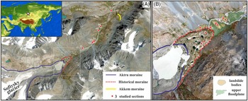
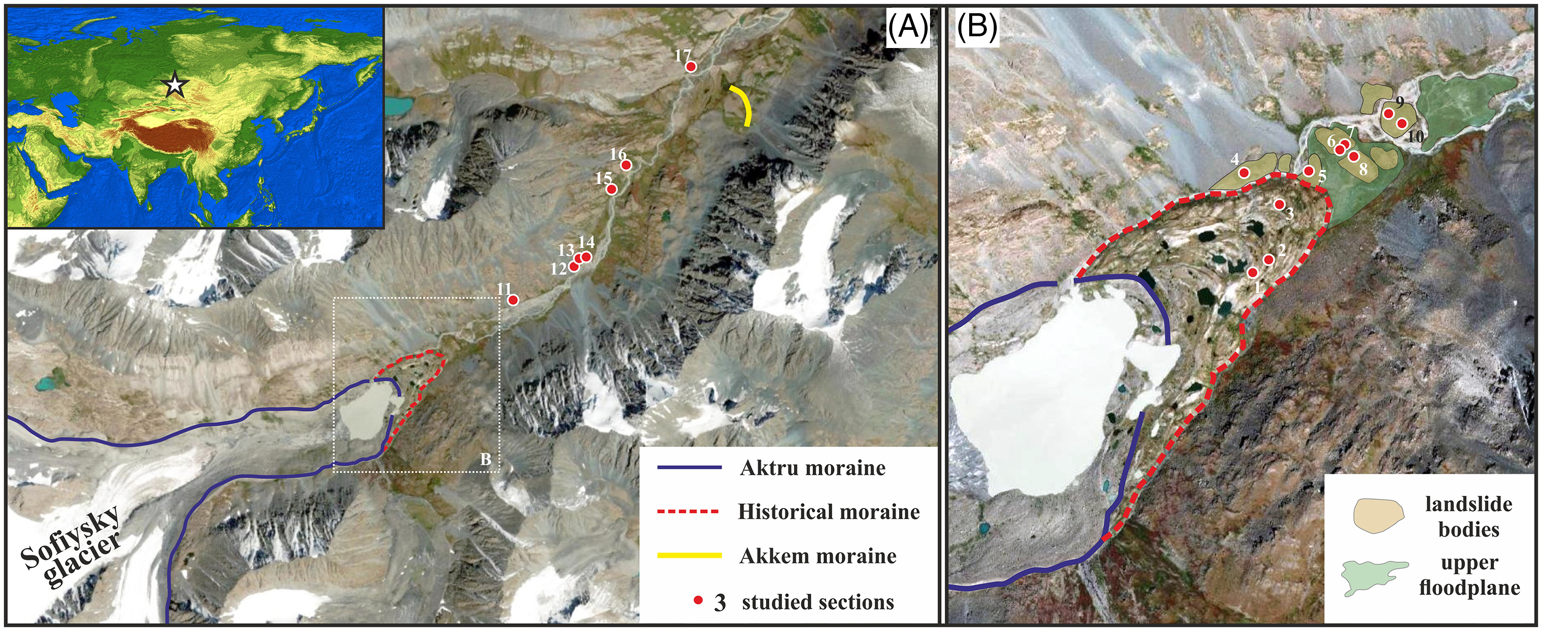
The headwaters of the Akkol river, examined in this paper, are located in the northern slope of the South Chuya range, in the southeastern part of the Russian Altai (SE Altai) (Figure 1). The Akkol river, which is 19 km long with altitudes of 2580–2130 m a.s.l. from mouth to confluence, originates from the Sofiysky glacier, one of the largest in the Russian Altai. The glacier occupies the axial part of the range with the highest summits within the ice catchment up to 3633–3867 m a.s.l. Like other Altai glaciers, the Sofiysky glacier is rapidly retreating at an average rate about 18 m/a over the 20th century (Pattyn et al. Reference Pattyn, De Smedt, De Brabander, Van Huele, Agatova, Mistrukov and Decleir2003). In August 2020, the edge of the glacier tongue was at 2575–2580 m a.s.l. (Agatova et al. Reference Agatova, Nepop, Nazarov, Ovchinnikov and Moska2021). The milky white color of the water gave the river its name (“Akkol” is a white river in Turkic). The white color is a result of a huge amount of transported mica, which is supplied by water runoff from the Sofiysky glacier. The different petrographic composition of rocks within slopes and axial part of the range here provides confidential determination of the source area of debris material which is deposited in the accumulative landforms in the upper part of the valley.
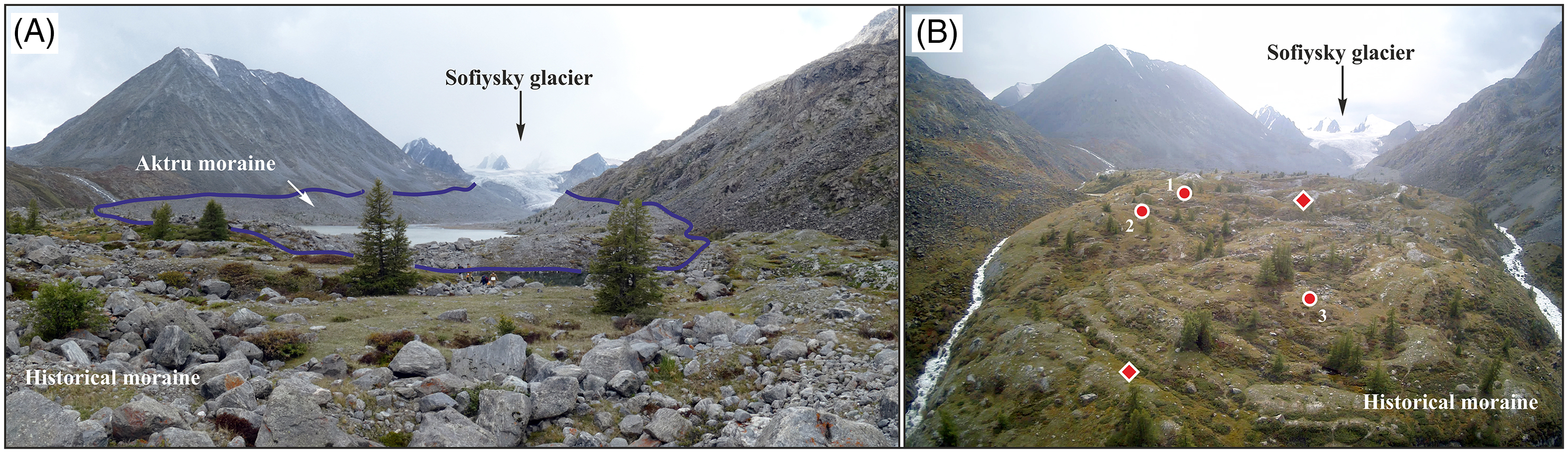
The Holocene moraines of different ages in headwaters of the Akkol trough valley (A) and studied sites within the Historical moraine complex and adjacent landslide bodies (B).
The modern ultra-continental climate in the region is characterized by pronounced annual temperature variations. According to the nearest Kosh-Agach meteorological station (55 km eastward, 1830 m a.s.l.) located in the Chuya intermountain basin, the mean annual temperature is –5.2°C, and the mean annual precipitation is less than 120 mm. Within the axial part of the ranges, which are up to 3900–4170 m a.s.l., precipitation is an order of magnitude higher and controls the modern glaciation. Precipitation decreases in the southeast direction.
The region is characterized by a cryoarid, permafrost-affected environment (Permafrost-hydrogeological map). Within mountain ranges, including the Akkol valley, unconsolidated sediments are frozen from a depth of about 0.8–1.5 m (Egli et al. Reference Egli, Lessovaia, Chistyakov, Inozemzev, Polekhovsky and Ganyushkin2015). The thickness of the active layer has increased over the past 20 years. According to the geobotanical zonation (Ogureeva Reference Ogureeva1980), the upper reaches of the Akkol river belongs to the alpine-tundra altitudinal belt of the Chuya–Argut region of the Central Altai sub-province, predominantly characterized by meadows and mountainous tundra.
The postglacial Holocene period shows different stages of soil formation in the region at various altitudes—from the basin floors up to the heads of valleys (Egli et al. Reference Egli, Lessovaia, Chistyakov, Inozemzev, Polekhovsky and Ganyushkin2015; Bronnikova et al. Reference Bronnikova, Konoplianikova, Agatova, Nepop and Lebedeva2018). At the highest positions, humid and relatively warm Early Holocene stage of forest pedogenesis, as well as a Late Holocene (last 3–4 ka) cold humid phase, presumably under mountain tundra and/or alpines, are recorded. Within the basins, the coldest, ultra-continental moisture-deficient soil-formation conditions for the entire Holocene have been recorded in the last 1–2 ka (Bronnikova et al. Reference Bronnikova, Konoplianikova, Agatova, Nepop and Lebedeva2018).
Forest development near the upper forest line within the study area is limited by temperatures during the growing season and decreasing precipitation in the southeast direction. Under these conditions, factors controlling forest development are slope exposure and groundwater inflow, often associated with permafrost. Today the upper forest line (∼2220–2330 m a.s.l.) is slightly above or equal to the altitudes of glacier terminuses, and the upper limit of young tree expansion is about 2400–2470 m a.s.l. Within the northern slope of the South Chuya range, Larix sibirica Ledeb is the forest-forming specie. Absence of Pinus sibirica Du Tour here (including the headwaters of the Akkol river) is defined by its sensitivity to moisture deficit, while on the northern slope of the North Chuya range, located westward, Pinus sibirica is one of the forest-forming species.
METHODS
To estimate the chronological limits of the studied nature events, radiocarbon dating of organic rich materials (peats, soils, wood fragments, plant detritus) was carried out. Depending on the weight of the sample, a liquid scintillation counting (LSC) or accelerated mass-spectrometry (AMS) technique was applied. The first one was utilized at the Institute of Geology and Mineralogy SB RAS, Novosibirsk (SOAN), and at the Institute of Geography RAS, Moscow (IGAN). The production of lithium carbide and benzene synthesis was completed by using the standard technique (Skripkin and Kovaliukh Reference Skripkin and Kovaliukh1997). The activity of 14C was determined by using the Quantulus-1220 liquid scintillation counters. Two dates applying the AMS technique (IGANAMS) were obtained at the University of Georgia, USA. The sample preparation, separation of the datable fraction, graphitisation and pressing on a target were performed at the Institute of Geography RAS, Moscow. All 14C ages were normalized to δ13C value of –25‰. The conventional radiocarbon ages were calibrated (2σ standard deviation; Supplementary Material 1) by applying the CALIB Rev 8.2 program (http://calib.org), with the IntCal20 calibration data set (Reimer et al. Reference Reimer, Austin, Bard, Bayliss, Blackwell, Bronk Ramsey, Butzin, Cheng, Edwards, Friedrich, Grootes, Guilderson, Hajdas, Heaton, Hogg, Hughen, Kromer, Manning, Muscheler, Palmer, Pearson, Van der Plicht, Reimer, Richards, Scott, Southon, Turney, Wacker, Adolphi, Büntgen, Capano, Fahrni, Fogtmann-Schulz, Friedrich, Köhler, Kudsk, Miyake, Olsen, Reinig, Sakamoto, Sookdeo and Talamo2020).
To date sandy glaciofluvial deposits, one OSL sample was collected into a steel tube to protect the sediment from sunlight. The sample was processed at the Institute of Physics, Silesian University of Technology, Poland (GdTL). High-resolution gamma spectrometry using a HPGe detector was applied to determine the content of U, Th, and K in the samples. The activities of the isotopes present in the sediment were determined by using IAEA standards RGU, RGTh, RGK after subtracting background values from the detector. The dose rates were calculated by using the conversion factors of Guerin et al. (Reference Guerin, Mercier and Adamiec2011). An automated Risø TL/OSL DA-20 reader was used for the OSL measurements of multigrain aliquots, each of ca. 1 mg. The stimulation light source was a blue (470 ± 30 nm) light emitting diode array delivering 50 mW/cm2 at the sample. Detection was through 7.5 mm of Hoya U-340 filter. Equivalent doses were determined using the single-aliquot regenerative-dose (SAR) protocol (Murray and Wintle Reference Murray and Wintle2000). To calculate the luminescence age (Supplementary Material 2), the central age model (CAM) of Galbraith et al. (Reference Galbraith, Roberts, Laslett, Yoshida and Olley1999) was applied.
Fragments of pine trunks collected on the moraine of the Historical stage in the Akkol valley were dendrochronologically dated applying the “Aktru” chronology (Nazarov and Myglan Reference Nazarov and Myglan2012), which is 1188 years long (AD 822–2010) and was built on Pinus sibirica Du Tour.
Geomorphological investigations included field study and analysis of remote sensing data. Also, analysis of soil cover and vegetation spread were used for distinguishing Aktru and Historical moraines, which form a single complex in front of the Sofiysky glacier. The analysis of accumulative bodies morphology, their position in the geomorphological system, petrographic composition and roundness of composing debris, matrix features, allowed the establishment of the genesis of landforms near and downstream from the Historical moraine. The study of sections and sampling for 14C and OSL dating were carried out in pits and natural outcrops.
RESULTS
Thirty-four 14C (Supplementary Material 1), one OSL (Supplementary Material 2), and 8 dendrochronological dates formed the chronological basis of paleoglaciological reconstructions.
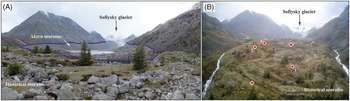
Detailed geomorphological investigations allowed clarification of the limits of the LIA glacier advance at the head of the Akkol valley. The surface of the Aktru moraine is not turfed and not covered with soil. It shows numerous unweathered blocks of gneisses and granites. The terminal and lateral ramparts are settling by sparse undergrowth of Larix sibirica, Picea obovata, and Betula pendula. There are only small areas occupied by mosses and lichens. All this results in a gray color of the surface and, despite the similar petrographic composition, distinguishes it from the Historical moraine.
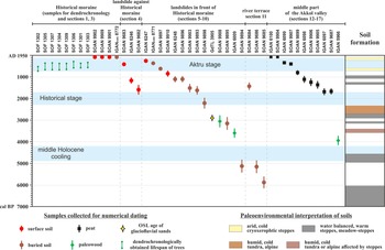
The more ancient Historical moraines are sodded, have a soil cover, and more intensive settlement by tree vegetation. The studied surface soil profiles in sections 1–3 (Figure 2) are quite developed. The thickness of horizon A reaches 19–23 cm (section 3). It is formed by mica sands, which serve as a matrix between gneiss and granite boulders and pebbles. The soil profile has signs of cryoturbation—the bottom of humus horizon is uneven and wedge-shaped, which is emphasized by the inclined (up to sub-vertical) position of gneiss fragments in the underlying substrate. Lenses of low-humus sands about 7 cm thick discovered below (at depth 27–34 cm), could be evidence of a relatively long pedogenesis. Nevertheless, the radiocarbon dating returned modern ages not only for surface soil (SOAN-9909, 9901), but also for a lens of humus sand at a depth of 27–34 cm (IGANAMS 8772; Figure 3).
Contact of Akrtu and Historical moraines (A) in the upper part of the Akkol valley; and position of studied sites (circles—sections; rhombus—locations of paleotree finds) (B).
Radiocarbon, dendrochronological, and OSL dates, obtained for the head of the Akkol valley. Holocene glaciers stages are given after Agatova et al. (Reference Agatova, Nepop, Nazarov, Ovchinnikov and Moska2021), pedogenesis features—after Bronnikova et al. (Reference Bronnikova, Konoplianikova, Agatova, Nepop and Lebedeva2018).
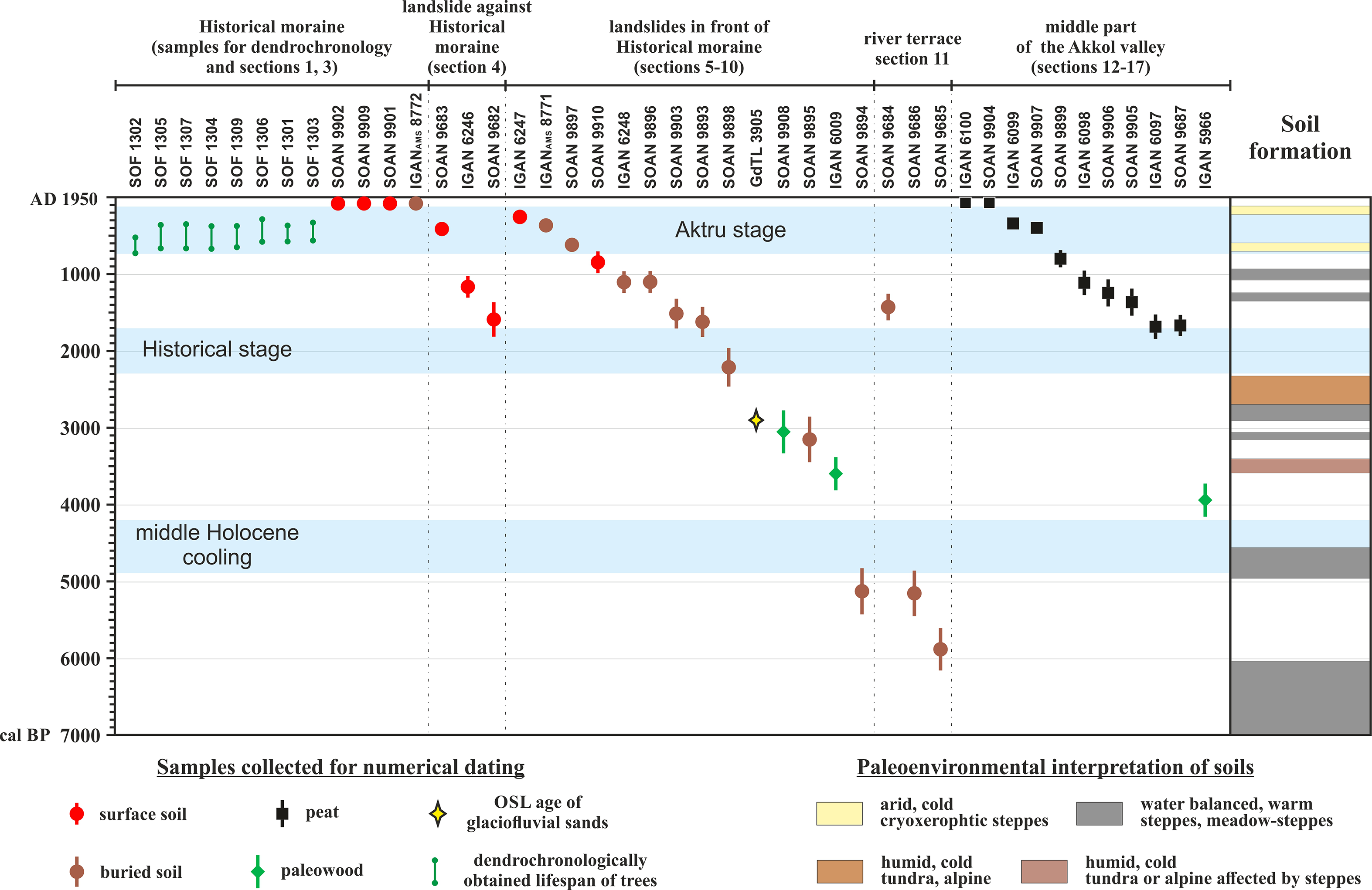
Possible rejuvenation can be associated with modern pedogenesis caused by post-LIA warming and mixing of organic material as a result of cryoturbation and permafrost degradation. Soil formation on the Historical moraine began before the LIA. This is evidenced by the significant thickness of the humus horizon formed under severe climatic conditions (on the Aktru moraine soil profile is absent), as well as by the finds of paleotrunks of Pinus sibirica Du Tour (AD 1218–1670) on the sodded moraine surface near the sites of soil sampling (Figures 2 and 3). We do not rule out that pedogenesis on the Historical moraine continued during the LIA (as in section 4 on the surface of landslide next to this moraine), and it is obvious that pedogenesis continues now, in the post-LIA warming. Contemporary pedogenesis and the open character of the soil system are confirmed by the modern radiocarbon date at a depth of 27–34 cm.
Ice degradation in the Historical moraine could have begun during warming before the LIA, but it was in the post-LIA time and especially in the last 20–25 years that this degradation became more intense. This conclusion is confirmed by our field observations in the Akkol valley since 1995, and by interpretation of aerial and space images from different years. There are pronounced changes in the number, shape and level of thermokarst lakes on the surface of the Historical moraine. The surface of the moraine itself also changes as it slides down the valley. Its specific shape, similar to the shape of rock glacier, is identified in the images and photographs (Figures 1 and 2). This advance results in burial of the nearest landslide and modern larches along the moraine front. All these post-LIA process contributes to the penetration of modern OM into the lower horizons of the soil profile. On the landslides along the front of the Historical moraine, where no obvious traces of permafrost degradation, 14C ages of humus horizon of surface soil at a depth of 15–30 cm fall within the time interval 1.2–5.4 cal kBP (SOAN-9682, IGAN 6246 [section 4, Supplementary Material 1]; UZN 6104 [Egli et al. Reference Egli, Lessovaia, Chistyakov, Inozemzev, Polekhovsky and Ganyushkin2015]), and even at a depth of 12–15 cm, 14C ages of humus horizon are about 0.4 cal kBP (SOAN-9683, section 4) and 3.5 cal kBP (UZN 6103; Egli et al. Reference Egli, Lessovaia, Chistyakov, Inozemzev, Polekhovsky and Ganyushkin2015). So, in spite of the modern 14C age obtained for soil at 27–34 cm on the surface of the Historical moraine (section 3), we argue that pedogenesis began here before LIA.
Shrub (Salicaceae, Juniperus, Lonicera, Betula rotundifolia) and tree (Larix sibirica Ledeb, Picea obovata) vegetation actively colonize the surface of the Historical moraine. The oldest larches grow within the frontal part of the moraine complex. In its proximal part, the oldest living trees have been dated dendrochronologically to AD 1897 (Neuwirth et al. Reference Neuwirth, Mahlberg, Herget, Borodavko, Glazirin, Herget and Severskiy2013). Paleowood fragments of Pinus sibirica Du Tour were discovered on the moraine surface (Figure 2). Dendrochronologically established lifetime of eight paleotrees is AD 1218–1670 (Figure 3). Trees settled the Historical moraine before and during LIA, and were killed by environmental worsening associated with advancing glacier during the Aktru stage. Being more sensitive to temperature and moisture in comparison to Larix sibirica, today pines do not grow within the South Chuya range. Thus, the lifetime of paleotrees of Pinus sibirica and the age of new growth of Larix sibirica confirm the age separation of the moraine complexes closest to Sofiysky glacier.
To estimate the magnitude of glacier advances in the middle of the Holocene, the relationship between glacial and non-glacial landforms was studied by applying a geomorphological approach, as well as numerical dating was utilized (Supplementary Materials 1 and 2). A set of landslides were established in front of the Historical moraine (Figure 2), some of which were earlier reported as moraines.
The landslide previously studied by Egli et al. (Reference Egli, Lessovaia, Chistyakov, Inozemzev, Polekhovsky and Ganyushkin2015), in the context of the Holocene pedogenesis, is composed of unrounded large blocks of crystalline quartz-chlorite schists and repeats the petrographic composition of rocks at the left slope of the valley. Such petrographic composition differs from the rocks in the axial part of the South Chuya range—gneisses and granites, that dominate in the structure of the Historical and Aktru moraines—and argues against glacial origin of this landform. It could be classified as a rock-fall or rockslide like other accumulation bodies of schists blocks, in which there is practically no fine-grained matrix between the unrounded debris. On the contrary, in the internal structure of the neighboring Historical moraine, sand with a high content of mica forms a matrix (up to a third of the total volume), where the “suspended” boulders often do not touch.
Landslides in this part of the Akkol valley (sections 5–10; Figure 2) were induced earlier than 5.1–3.6 cal kBP, as evidenced by the oldest fossil soil on the landslide surface (SOAN-9894, section 6), as well as by fragments of larch bark discovered under glaciofluvial cover of landslide deposits among debris (IGAN 6009, section 9). Landslide bodies have no traces of glacier impact but were affected by glaciofluvial processes and further pedogenesis. Loess-soil series with at least one, but more often with two or three buried humus horizons were developed over the laminated glaciofluvial micaceous sands. Today, larches growing on the landslides near the Historical moraine are the oldest in the upper reaches of the Akkol valley. Previous generation of Larix sibirica settled landslides at about 3.6–3 cal kBP (IGAN 6009, SOAN-9908), and could be keeled at about 3 ka ago by abrupt watering, probably associated with active ice melting in the Sofiysky glacier and/or the possible draining of periglacial paleolake. It is evidenced by OSL age (GdTL-3905) of micaceous fluvial sands, that cover tree remnants. The age of fossil soils and buried tree fragments (the oldest 14C date 5130 ± 305 cal BP, SOAN-9894) post-date the last Sofiysky glacier advance beyond the limits of the Historical stage.
Another landslide (section 4; Figure 2) occupies the same position as the Historical moraine and may partially overlap it. Blocks of metamorphic quartz-chlorite schists, which are presented at the valley slope here, compose the landslide and the large non-turfed talus resting on it. The 14C dates of polygenetic soil profile studied on the landslide surface, indicate the beginning of the pedogenesis in the warm interstage period and its continuation during the Aktru stage (ca. 0.4–1.6 cal kBP, SOAN-9683, 9682; IGAN 6246; Figure 3). Pedogenesis in the headwaters of the Akkol valley in time between the Historical and Aktru stages, is also evidenced by the 14C ages of buried and surface soils in sections 5, 7-9, 11(Supplementary Material 1; Figure 3).
Downstream the Historical moraine, the valley bottom represents a floodplain with fragments of terraces preserved at the foot of large talus fans and between the rocky protrusions. The last ones are polished by the glacier and partly covered by moraine deposits. Dating of a lens of humified material with inclusions of charcoal and a large amount of root detritus above alluvial boulders in the lower river terrace 1.2 km far from the front of the Historical moraine (section 11) indicates terrace formation ca. 5.9–5.1 cal kBP (SOAN-9685, 9686). The presence of sandy loams and clay interlayers affected by post-sedimentary cryogenic deformations may indicate repeated increase in water runoff and possible rise in the water level during sedimentation.
A non-distant advance of the Sofiysky glacier in the middle of the Holocene is also supported by the age of charred wood fragment 1.7 km upstream from the supposed Akkem moraine (section 16, IGAN 5966), the meltwater runoff from the glacier-controlled sedimentation patterns and peat accumulation in this part of the Akkol valley during the last 1700 years (sections 12–15, 17, Supplementary Material 1; Figure 3).
The rate of reforestation indirectly indicates the limit of glacier advance at the previous stage— the longer the glacier and the more time it takes for deglaciation, the later the forest vegetation will settle the previously glaciated part of the valley. More rapid reforestation after the advance of the Sofiysky glacier about 5–4 cal kBP compared to the reforestation after the Historical stage argues for the lesser glacial activity at that time.
DISCUSSION
Direct dating of glacial landforms is among the most comprehensive tasks and is often associated with the fortunate finds suitable for dating material. In this context buried soils in the heads of trough valleys are of a great interest both as paleoenvironmental archives and chronostratigraphic markers. The complexity of paleosol dating and geochronological interpretation of the obtained ages are often discussed in publications. Thus, mixing of old and young carbon in deposits is a common result of active tectonics and post-sedimentation evolution in high mountainous provinces. An extremely critical factor can be the contamination of old organic matter (OM) by “young” carbon. In contrast, the erosion and redeposition of pre-Quaternary sediments into Holocene deposits resulted in an overestimation of their 14C ages. Within tectonically active mountain terrains, including Altai, both processes could be observed (Nepop et al. Reference Nepop, Agatova, Bronnikova, Zazovskaya, Ovchinnikov and Moska2020 and references therein).
Radiocarbon dating of soil organic matter meets specific difficulties due to complexity of the pedogenesis process. This OM consists of various components of different ages. Its contamination by invasion of roots, infiltration of organic compositions dissolved in water, influence of microorganisms, and of soil fauna usually results in rejuvenation of obtained ages. Thus, being a partly open system for carbon exchange, paleosol is a very complicated subject for radiocarbon dating. It was clearly demonstrated by 14C dating of fossil and contemporary soils at the top of the glaciofluvial deposits (sections 9 and 10). OM of significantly different age was revealed in the same soil horizon, as well as in fossil soils developed on the northern and southern slopes of the small (about 200 × 150 m) landslide. LSC date of the Larix sibirica bark (discovered between the blocks composed the landslide body) at the base of the section 9 indicates the beginning of sedimentation about 3.6 cal kBP (IGAN 6009). This date is consistent with two LSC dates (IGAN 6248, IGAN 6247) for buried and surface soils, overlying glaciofluvial sands at depths of 22–32 and 10–15 cm below the surface.
Earlier, 14С AMS dates of stable OM 5393 ± 76 cal BP (UZN 6104) and 3516 ± 63 cal BP (UZN 6103) for 15–30 and 0–15 cm of the surface soil were reported by Egli et al. (Reference Egli, Lessovaia, Chistyakov, Inozemzev, Polekhovsky and Ganyushkin2015) for the southern slope of this landslide (section 10). Like in section 9, soil in this location was formed on fluvial sands. At the same time, it includes fragments of gneisses—the eroded moraine substrate that composes the Akkol floodplain, covered by landslide body. Redating of buried soil in this location returns different ages: LSC 2215 ± 270 cal BP (SOAN-9898, made on humic acids) and AMS 385 ± 75 cal BP (IGANAMS8771, made on total organic carbon). Thus, one the same humus horizon was characterized by three different radiocarbon dates ∼5.4, 2.2, and 0.4 cal kBP (UZN 6104, SOAN-9898, IGANAMS8771). Most likely, the ancient OM indicates the beginning of soil formation in this location. This hypothesis is supported by the presence of OM of similar age (5130 ± 305 cal BP SOAN-9894) in soil covered the nearby landslide (section 6). Obtained the near-modern age is most likely a result of young OM influx into the open soil system during the pedogenesis. The same result is observed for sandy paleosol from a depth of 27–34 cm on the Historical moraine (section 3, IGANAMS 8772), where rejuvenation is possibly caused by modern pedogenesis and OM mixing because of cryoturbation and permafrost degradation.
Wood is an alternative dating material. In contrast to paleosol, it is biologically inert and physically stable in relation to isotopic changes with the environment, and, therefore, more appropriate material for radiocarbon dating. In the SE Altai, pieces of buried wood are usually imbricated among boulders on the surface of glaciofluvial deposits or embedded in it. Sometimes tree fragments have melted out directly from the glacier tongues or been pressed onto the substratum near the ice front. They show traces of glacier processing: abrasion, twists, ruptures, incisions, etc. They are also are heavily deformed and often covered by a specific crust of peeling wood. Wood fragments collected from dead trees at the moraine surfaces or at the upper tree limit on trough slopes are valuable materials. These trees were not directly affected by advanced glaciers but were killed by associated climate deterioration.
Sources of uncertainty in radiocarbon dating of paleowood include, first of all, the “old tree” effect. Burial and transportation of wood by glacier results in the loss of the outer tree rings. When dating the preserved central part of the trunk, the time elapsed before the death of the tree remains unknown. Another uncertainty is unknown time between a tree death and its burial by glacier. For example, in SE Altai, Larix sibirica can be preserved on a stone surface up to two thousand years. Similar, the time of recolonization of deglaciated areas by tree vegetation depends mainly on local conditions and could be estimated about 50–100 years and more for the SE Altai (Nazarov and Myglan Reference Nazarov and Myglan2012). The position of the upper timber limit also has a delayed response of about 100–200 years on climate changes (Hormes et al. Reference Hormes, Müller and Schlüchter2001).
The presented results from the Akkol valley (Supplementary Material 1) indicate that radiocarbon dating of both fossil soils and wood has, at best, an accuracy of a few hundred years. Regarding the paleowood, such age uncertainty is determined mainly by sample preservation, but not the possibilities of radiocarbon dating of wood.
Analysis of the radial growth of tree rings could supply much reliable evidence of glacier fluctuations through its annual precision. Today, within the study area there are good opportunities to obtain dendrochronological ages for Larix sibirica Ledeb up to 3200 years and for Pinus sibirica Du Tour up to 1200 years (Nazarov and Myglan Reference Nazarov and Myglan2012). The success of dating practically does not depend on the location of collected samples. The only requirement is that the altitude to be no lower than 2100 m a.s.l. Below this mark, the effect of the main limiting factor, temperature, is significantly reduced.
Due to their response characteristics, the mountain glacier is much slower natural system compared to the reaction of an individual tree. It could vary from tens to more than one hundred years (Haeberli and Hoelzle Reference Haeberli and Hoelzle1995). The previously estimated length response time (the parameter which characterizes the glacier’s steady-state sensitivity to sudden mass-balance changes) and the reaction time (which is defined as the time lag between a sinusoidal climate forcing and the pseudo-sinusoidal front variation response of a glacier) for Sofiysky glacier are about one hundred years (De Smedt and Pattyn Reference De Smedt and Pattyn2003). Thus, glacier oscillations generally are not affected by decadal climate fluctuations and follow the major climatic trend.
CONCLUSION
Radiocarbon dating of paleowood fragments, fossil soils, and peats in a previously glaciated area in the upper reaches of the Akkol trough valley allows drawing these conclusions:
1. Climate deterioration in the SE Altai in the middle of the Holocene is recorded in various natural archives. Nevertheless, the duration and intensity of these changes were less significant than previously assumed. Ages of buried soils in the upper reaches of the Akkol valley indicate that 5–4 cal kBP the Sofiysky glacier advanced downstream the valley no fare than the front of the Historical moraine.
2. Possible hiatus in reforestation within the time interval 4.9–4.2 cal kBP is not enough for distant glacier advance (about 5–6 km away from modern glaciers) and formation of the Akkem moraine. Dating of landforms without traces of glacial influence in the head of trough valley indicates that accumulation of the Akkem moraine occurred much earlier than 6–5 cal kBP.
These conclusions can be extended to other trough valleys in the ranges of the SE Altai.
Supplementary material
To view supplementary material for this article, please visit https://doi.org/10.1017/RDC.2022.74