The consequences of grassland degradation are dust storms and biodiversity loss (Harris Reference Harris2010). Soil erosion is also a significant grassland degradation problem, with widespread and serious negative effects on soil nutrients (Fu et al. Reference Fu, Meng, Qiu, Zhao, Zhang and Davidson2004), agricultural production (Lin et al. Reference Lin, Tu, Huang and Chen2009), water quality (Li & Zhang Reference Li and Zhang2010) and biodiversity (Dang Reference Dang2007), all of which have economic impacts (Fu et al. Reference Fu, Zhao, Chen, Zhang, Lu, Gulinck and Poesen2005; Fu et al. Reference Fu, Liu, Lu, He, Zeng and Wu2011). Consequently, soil erosion has become a central issue for resource and environmental management (Alewell et al. Reference Alewell, Egli and Meusburger2015) and poses a major challenge to sustainable development (Wen et al. Reference Wen, Zheng, Shen, Bian and Jiang2015).
The Tibetan Plateau, an important ecological barrier in western China, is well known for climatic regulation, water and soil conservation, and biodiversity maintenance (Nie et al. Reference Lu, Yan, Sun, Zhang, Chen, Wang and Cheng2010). Recently, the Tibetan Plateau has suffered from severe soil degradation due to livestock, overgrazing and excessive soil disturbance from animals (Ochotona curzoniae) (Harris Reference Harris2010). Therefore, the area has become more fragile and sensitive to climatic change (Sun et al. Reference Sun, Cheng and Li2013a).
On the Tibetan Plateau, environmental degradation has attracted the attention of governments and international societies, and, as a result, policymakers have become aware of the importance of protecting the environment. The Tibetan Ecological Security Barrier Protection and Construction Plan (TESBPC) is a major initiative concerned with ecological security and future development. Over the past few years, engineering has played an important role in ecological protection and economic development. Assessing soil erosion intensity is an important issue for controlling soil erosion and improving environmental quality (Xu et al. Reference Xu, Qiao, Pan, Hou, Roos and Cao2015) on the Tibetan Plateau. Numerous studies have made significant contributions to our understanding of water erosion (Quine et al. Reference Quine, Walling and Zhang1999; Zhang et al. Reference Zhang, Yang and Zepp2004; Zhang et al. Reference Zhang, Li, Tang, Zeng, Huang, Guo, Chen and Hirsh2013), wind erosion (Chen et al. Reference Chen, Song and Dong2002; Chen et al. Reference Chen, Zhao, Qiao, Zhang, Zhu and Xu2009) and freeze–thaw erosion (Zhao et al. Reference Zhao, Wang, Cruse and Chen2012; Kong & Yu Reference Kong and Yu2013; Guo et al. Reference Guo, Zhou, Zhu, Liu, Wang, Wang and Jiang2015). For the Tibetan Plateau, soil conservation plays an important role in the functions of ecosystems and in the environmental evaluation of soil conservation to assist regional planning. Some researchers have estimated soil erosion using the 137Cs technique, and also reveal the mechanisms of water and soil erosion (Nie et al. Reference Lu, Yan, Sun, Zhang, Chen, Wang and Cheng2010; Shao et al. Reference Shao, Xiao, Liu and Qi2011; Wang et al. Reference Wang, Niu, Wu and Gao2014) at the watershed scale. Although soil erosion in this cold region is a well-recognised problem (Alewell et al. Reference Alewell, Egli and Meusburger2015), a comprehensive assessment of practical soil erosion, potential soil erosion and soil conservation on the Tibetan Plateau is still missing. In our study, practical soil erosion, potential soil erosion and soil conservation were calculated using the Revised Universal Soil Loss Equation (RUSLE) model.
The present study aims to identify the spatial and temporal patterns of potential soil erosion, practical soil erosion and soil conservation. The value of soil conservation is also assessed. The results are fundamental in understanding changes in ecosystem functions in ecologically fragile regions and to promote ecological awareness on the Tibetan Plateau.
1. Materials and method
1.1. Study area
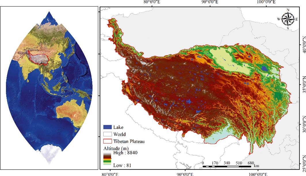
The Tibetan Plateau is located in SW China, occupying a total area of more than 2.50×10⁶km2 (Fig. 1) and with an average elevation of 4300m. In the Qiangtang region, the average altitude exceeds 5000m. Due to its extensive territory and highly dissected topography, the Tibetan Plateau has a unique climate (Lu et al. Reference Lu, Yan, Sun, Zhang, Chen, Wang and Cheng2015). The climate on the plateau is cold and relatively humid in the S and SE parts. The mean annual temperature is 1.6°C, and the mean annual precipitation is 413.6mm (Yang et al. Reference Yang, Fang, Ji, Ma, Su and Tang2010). The maximum annual precipitation is 2817mm in the eastern Tibetan Plateau and is approximately 30mm in the Qaidam Basin. The main grasslands include alpine meadow, alpine steppe and alpine desert steppe. The high altitude and alpine steppe are interspersed with mountain ranges and large lakes (Sun et al. Reference Sun, Cheng, Li, Sha and Yang2013b).
Location and topographical situation of study area.

1.2. Data sources
The precipitation data were obtained from the Meteorology Information Center of the Chinese National Bureau of Meteorology. The precipitation data were processed to obtain mean annual values. In addition, spatial interpolation of precipitation was analysed using Anusplin 4.2 software (Centre for Resource and Environmental Studies, Australian National University, Canberra), with a resolution of 1km. The data on soil nitrogen content (9km) were collected from the dataset of Zhu (Reference Zhu2006) and all soil properties were used to calculate soil erodibility and nutrient status. It is important to note that the spatial interpolation method was used to reveal the distribution of soil properties based on many field investigations. The Digital Elevation Model (90m) was used to calculate slope gradient and slope length. The data on land use type were supplied by the Institute of Remote Sensing and Digital Earth, Chinese Academy of Sciences, based on 1:100,000 maps.
1.3. Methods
1.3.1. Soil conservation modelling
Soil conservation can be defined as the difference between potential soil erosion and actual soil erosion, and can be computed using the following formula (Fu et al. Reference Fu, Liu, Lu, He, Zeng and Wu2011):
 $$A_c = A_p = A_r$$
where Ap=potential soil erosion (thm–2a–1); Ar=practical soil erosion (thm–2a–1); and Ac=soil conservation (thm–2a–1). Potential soil erosion is soil erosion without vegetation cover and soil control practices. Actual soil erosion is erosion under the current vegetation cover and soil control measures. Potential soil erosion, practical soil erosion and soil conservation can be modelled using RUSLE (Wischmeier & Smith Reference Wischmeier and Smith1965):
 $$A = R \times K \times LS \times C \times P$$
where A is soil erosion (thm–2a–1); R is rainfall erosivity (MJ mm ha–1 h–1 yr–1); K is the soil erodibility factor; LS is the topographical factor, which combines slope gradient factor and slope length factor; C is the vegetation cover and management factor; and P indicates the soil control practice.
The rainfall erosivity (R) factor is computed based on monthly and annually rainfall using the following formula (Wischmeier & Smith Reference Wischmeier and Smith1978):
 $$R = \sum^{12}_{i=1} 1.735 \times 10^{(1.5 \log (P^2_i / P ) -0.08188) }$$
where Pi is the total rainfall (mm) in a month and P is the annual rainfall (mm).
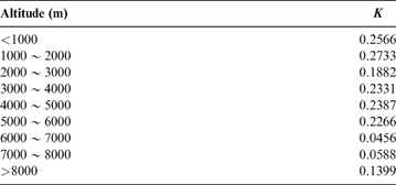
According to Liu et al. (Reference Liu, Tao, Shi, Song and Guo2014), the soil erodibility (K) factor is referenced as in Table 1.
K values for different land use types.

According to Huang et al. (Reference Huang, Hong, Zhang and Du2004), the topographical factor (LS) is as follows:
 $$L = (\lambda / 22.13)^m
\cases {
m=0.2,&$\theta < 1^{\circ}$ \cr
m=0.3,&$1^{\circ} < \theta < 3^{\circ}$ \cr
m=0.4,&$3^{\circ} < \theta < 5^{\circ}$ \cr
m=0.5,&$\theta > 5^{\circ}$
}
$$
 $$S =
\cases {
10.8 \sin \theta + 0.03,&$\theta < 5^{\circ}$ \cr
16.8 \sin \theta - 0.50,&$5^{\circ} \le \theta \le 10^{\circ}$ \cr
21.9 \sin \theta - 0.96,&$\theta > 10^{\circ}$
}
$$
where L and S are the slope length and slope gradient factor, respectively; m is the percentage of slope; and λ is the slope length (m).
Determination of the vegetation cover (C) factor is calculated as follows (Fu et al. Reference Fu, Liu, Lu, He, Zeng and Wu2011):
 $$C =
\cases {
1,&$f_c = 0$ \vskip6\cr
0.6508 - 0.3436 \log f_c,&$ 0 < f_c \le 78.3% $ \vskip6\cr
0,&$f_c \ge 78.3%$
}
$$
To calculate the vegetation coverage (fc) factor, the Normalised Difference Vegetation Index (NDVI) derived from moderate resolution imaging spectroradiometer (MODIS) images was used.
 $$f_c = {NDVI - NDVI_\min \over NDVI_\max - NDVI_\min }$$
where NDVI min=NDVI of bare soil; and NDVI max=the regional maximum of NDVI.
The erosion control practice (P) factor of alpine meadow, alpine steppe, alpine desert steppe and forest is 1 for the land use types without any protection measures. The P of farmland and water is 0.15 (Li & Zheng Reference Li and Zheng2012) and 0 (Fu & Zha Reference Fu and Zha2008), respectively.
The soil erosion rate across the Tibetan Plateau was analysed from 1984 to 2013.
1.3.2. Valuation of soil conservation services
A monetary valuation was carried out to assess the soil conservation services provided by the ecosystem. Three categories of services provided by soil erosion control were identified (Xiao et al. Reference Xiao, Xie and An2003): retaining soil nutrients, reducing wasteland formation and reducing sediment deposition. Eq. 8 was used to calculate the economic value of soil nutrients retained in agreement with the spatial distribution of the nutrient contents of different ecosystems on the Tibetan Plateau (Xiao et al. Reference Xiao, Xie and An2003):
 $$E_f = \sum QSC \times n \times C \times P$$
where Ef is the economic value of soil nutrients retained (RMBhm–2); QSC is the total amount of soil nutrients conserved (thm–2); C is the soil nutrient retention expressed as nitrogen, content (%); P is the market price (RMBt–1) of nitrate fertiliser; and H is the coefficient of available nitrogen (N) converted into diammonium phosphate fertiliser. The coefficient of available N converted into diammonium phosphate has a value of 14.0% (Wu et al. Reference Wu, He, Gao, Li and Luo2010). The average price of ammonium sulphates is 1825RMBt–1 (Han et al. Reference Han, Gao, Wang, Liu, Wang and Tuo2012).
The ecosystem service provided by preventing the formation of wasteland is valued using the opportunity cost method based on the following formula (Han et al. Reference Han, Gao, Wang, Liu, Wang and Tuo2012):
 $$E_i = QSC \times P_{oi} / \rho \times h \times 10^{-4}$$
where Ei is the value of reducing wasteland formation (RMBhm–2); Poi is the opportunity cost of the annual average income per unit area in different ecosystems (RMBhm–2a–1), and the mean value is 2350RMBhm–2a–1 (Han et al. Reference Han, Gao, Wang, Liu, Wang and Tuo2012); ρ is soil bulk density (tm–3); and soil depth is 0.5m.
The value of reducing sediment deposition is assessed using the impoundment cost method to calculate the economic value of reducing sediment deposition (Xiao et al. Reference Xiao, Xie and An2003):
 $$E_a = QSC / \rho \times 24% \times C$$
where Ea is the economic value of reducing sediment deposition (RMBhm–1); ρ is soil bulk density (tm–3); and C is the cost of the reservoir project (RMBm–3), and the cost of reservoir storage capacity is 5.714RMBm–3 in our analysis (Han et al. Reference Han, Gao, Wang, Liu, Wang and Tuo2012).
Finally, the dynamics of the soil conservation services across the Tibetan Plateau were analysed from 1984 to 2013.
2. Results
2.1. Potential, practical soil erosion and soil conservation at temporal and spatial scales
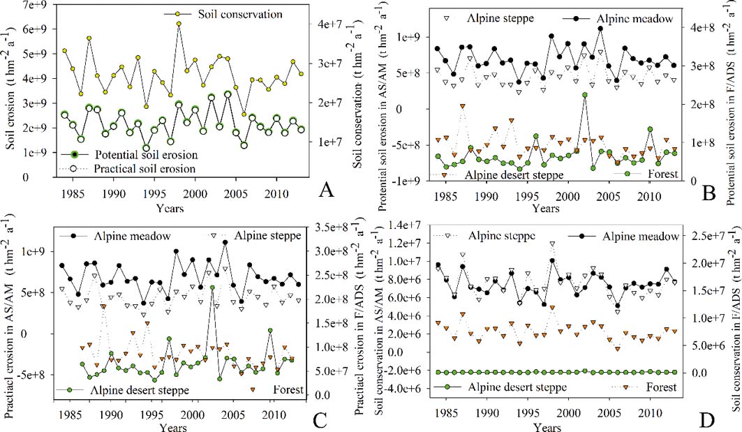
The potential soil erosion, practical soil erosion and soil conservation fluctuated throughout the years (1984–2013; Fig. 2a), with total values of 6.56×10¹⁰t, 6.48×10¹⁰t and 8.16×10⁸t, respectively. The maxima of the potential soil erosion and practical soil erosion was observed in 2004, and amounts were 3.37×10⁹t and 3.34×10⁹t, respectively. In addition, the maximum soil conservation was presented in 1998 (4.0×10⁷t). The minima of potential soil erosion and practical soil erosion were found in 1994 (1.19×10⁹t and 1.17×10⁹t); the minimum soil conservation was detected in 2006 (1.70×10⁷t). Figure 2b shows the temporal dynamics of potential soil erosion in different ecosystems from 1984 to 2013. Higher potential soil erosion was found in the alpine meadow ecosystem, followed by alpine steppe, forest and alpine desert steppe. Similarly, higher practical soil erosion was also found in the alpine meadow ecosystem, followed by alpine steppe, forest and alpine desert steppe (Fig. 2c). However, the ‘sequence' of soil conservation (Fig. 2d) was forest ecosystem > alpine meadow > alpine steppe > alpine desert steppe.
Dynamics of soil erosion across the Tibetan Plateau (1984 to 2013). Graphs A–D represent the dynamics of potential soil erosion, practical soil erosion and soil conservation (A) on the Tibetan Plateau, and potential soil erosion (B), practical soil erosion (C) and soil conservation (D) in the different ecosystems.

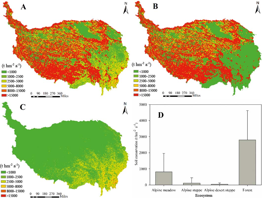
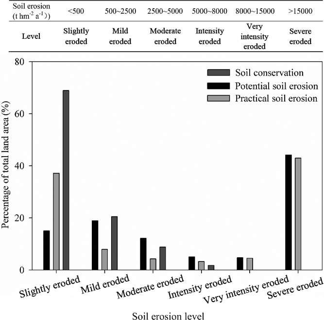
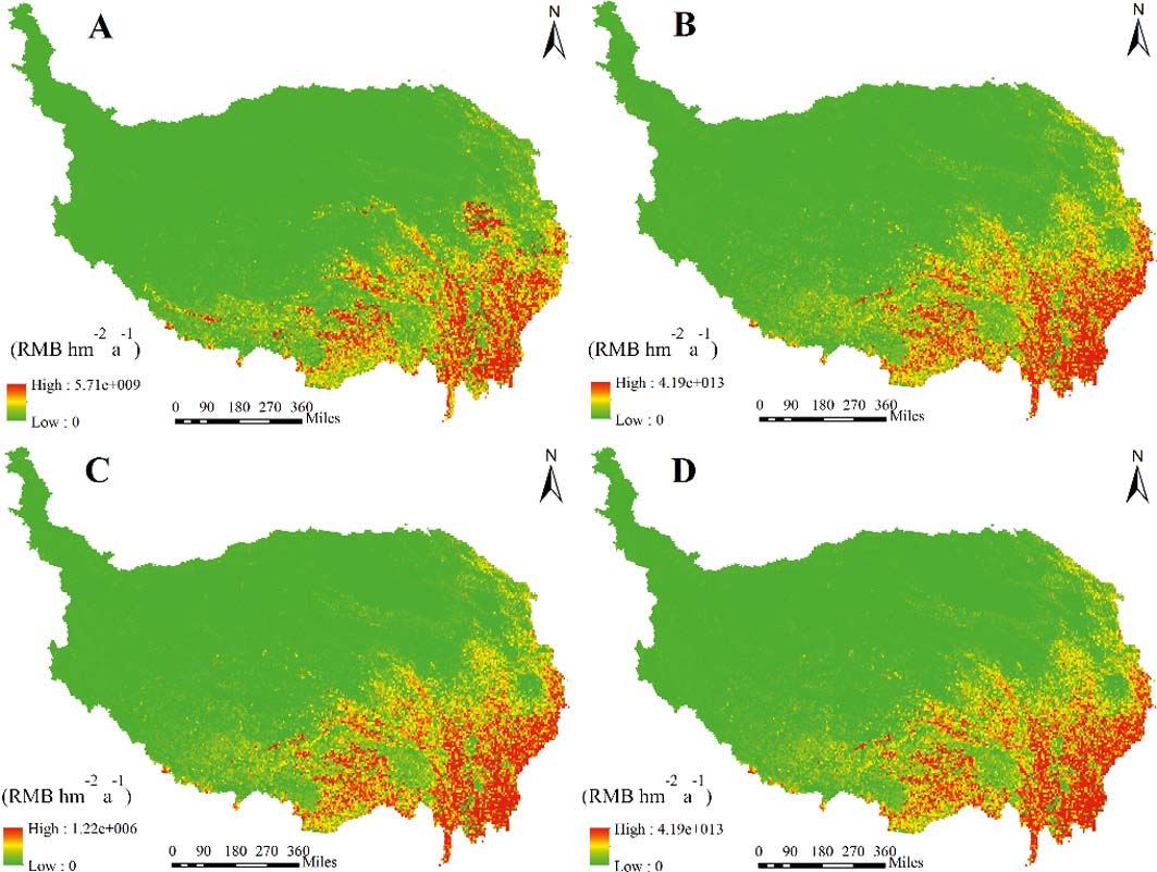
The average potential soil erosion was 2.19×10⁹ta–1 (Fig. 3a). Erosion in most regions of the Tibetan Plateau (except for the eastern Tibetan Plateau) was significant. Most regions of the Tibetan Plateau were severely eroded, and approximately 44.13% of the area had potential soil erosion greater than 15,000thm–2a–1 (severely eroded) (Fig. 4).
Average values of potential soil erosion (A), practical soil erosion (B), soil conservation (C), and soil conservation of different ecosystems (D) across the Tibetan Plateau (1984–2013).

Soil erosion levels in different areas, assessing potential soil erosion, practical soil erosion and soil conservation over the Tibetan Plateau.

The distribution of practical soil erosion on the Tibetan Plateau is shown in Figure 3b. The average practical soil erosion was 2.16×10⁹ta–1. The areas of slightly eroded and severely eroded practical soil erosion were up to 37.13% and 42.95%, respectively (Fig. 4).
The average soil retention was 2.72×10⁷ta–1 (Fig. 3c). Soil retention was high in the south-eastern Tibetan Plateau. However, in the northern and north-western Tibetan Plateau, with a forest and alpine meadow ecosystem, the soil retention capacity was low (Fig. 3d). The corresponding soil retentions were 2.80×10³ta–1and 8.09×10²ta–1 for the forest and alpine meadow, respectively.
2.2. The value of soil erosion control services
Nitrogen losses are caused by soil erosion; therefore, reducing nitrogen losses is one of the services provided by ecosystems. The economic value of reducing soil nutrients by soil loss can be expressed by the investment of equivalent chemical fertilisers. The annual average economic value of soil nutrient conservation was 5.93×10⁹RMBa–1 (Fig. 5a) – approximately 22.98RMBhm–2a–1. The annual average economic value of reducing wasteland formation was 2.55×10¹²RMBa–1 (Fig. 5b) – approximately 2.95×10⁵RMBhm–2a–1. Soil sediment deposits in lakes, rivers and reservoirs, and the capacity of water storage, will decrease. Hence, we used the cost of reservoir engineering to assess the economic value of reducing sediment deposition. The annual average economic value of reducing sediment deposition was 2.24×10⁶RMBa–1 (Fig. 5c). The total soil conservation service value (2.55×10¹²RMBa–1) across the Tibetan Plateau is shown in Figure 5d. Additionally, the value of soil conservation in the mid-northern Tibetan Plateau was lower. However, in the south-eastern Tibetan Plateau, the value of soil conservation was greater.
Average values of nitrogen conservation (A), reducing wasteland formation (B), reducing sediment deposition (C) and the value of total soil conservation (D) on the Tibetan Plateau (1984–2013).

The forest and alpine meadow ecosystems play an important role in soil conservation on the Tibetan Plateau (Fig. 6). The results showed that the annual average soil conservation of forest and alpine meadow ecosystems was 9.33×10¹²RMBa–1 and 2.71×10¹²RMBa–1, respectively, followed by alpine steppe and alpine desert steppe ecosystems.
Average economic value of soil conservation services in different ecosystems on the Tibetan Plateau (1984–2013).

3. Discussion
3.1. The temporal and spatial patterns of potential soil erosion, practical soil erosion and soil conservation
Potential soil erosion, practical soil erosion and soil conservation fluctuated throughout the years in different ecosystems. Even though the annual mean precipitation on the Tibetan Plateau has increased during the past few decades (Sun et al. Reference Sun, Cheng, Li, Sha and Yang2013b), the increasing tendency of NDVI (Piao et al. Reference Piao, Fang, Liu and Zhu2005) may account for the fluctuations in soil erosion. The stability of forest was relatively greater than grassland due to its developed fine-roots. Hence, soil conservation in the forest ecosystem was greater than in the other ecosystems. However, the level of practical soil erosion in the present study was lower than in the study by Xiao (Reference Xiao, Xie and An2003), possibly due to the different parameter values. The extensive distribution of sparse vegetation is the critical factor for the occurrence of severe soil erosion in most regions on the Tibetan Plateau (Fig. 3). However, the south-eastern Tibetan Plateau has the paradoxical combination of dense vegetation with very low soil erosion. As the forest ecosystem is mainly in the south-eastern Tibetan Plateau, the forest played a major role in controlling soil erosion on the Tibetan Plateau (Figs 3, 6). However, the low and no-sensitivities categories response to soil erosion were dominant in the north-western part (Wang et al. Reference Wang, Zhong and Fan2005) with the land use types of alpine steppe and alpine desert steppe. Similarly, we found that practical soil erosion in alpine meadow and alpine steppe was higher than that in forest (Fig. 2c), and the erosion rate of alpine meadow was 267tkm–2a–1; however, field observations indicated that the erosion rates on alpine meadow ranged from 415tkm–2a–1 to 875tkm–2a–1 in the source region of the Three Rivers (Shao et al. Reference Shao, Xiao, Liu and Qi2011). The differences here might be caused by the use of different research scales.
3.2. Driving factor of soil control service dynamics
In our analysis, we found that the annual soil conservation value for the Tibetan Plateau was 0.11thm–2a–1, which is lower than the observations (soil loss rate ranged from 3.60thm–2a–1 to 5.50thm–2a–1) made at different slope gradients on the Loess Plateau (Fu et al. Reference Fu, Liu, Lu, He, Zeng and Wu2011). However, practical soil erosion on the Tibetan Plateau was higher than that in other regions; for example, the mean soil loss rate in the Xiangxi catchment was 0.12thm–2a–1 (Schonbrodt et al. Reference Schonbrodt, Saumer, Behrens, Seeber and Scholten2010), the average soil erosion rate was 0.18thm–2a–1 in the Liao Watershed, Jiangxi Province (Li et al. Reference Li, Chen, Lim, Cai and Sagong2010), and lesser soil erosion rates were also found in other mountain areas (Chen et al. Reference Chen, Niu, Li, Zhang and Du2011; Zhou et al. Reference Zhou, Yang, Zhao, Cai and Ya2014; Zhu Reference Zhu2015). We concluded that soil erosion was severe under cold, high-altitude and fragile environmental conditions due to the interrelated effects of the increase in precipitation, low vegetation cover and overgrazing on grassland (Wang et al. Reference Wang, Niu, Wu and Gao2014). Thus, soil erosion on overgrazed grassland was sensitive to the increase in precipitation (Sun et al. Reference Sun, Cheng, Li, Sha and Yang2013b), especially the extreme precipitation in recent years. Rodent pests in pastures accelerated the degradation of vegetation (Li et al. Reference Li, Wang, Wang, Wang and Wu2007). Therefore, a vicious spiral cycle of soil erosion existed under low vegetation cover. In addition, rodents have damaged the vegetation on the Tibetan Plateau, and previous research reported that the mounds and pits covered up to 7% of the total area in Nagqu County (alpine steppe) (Wei et al. Reference Wei, Li, Yang and Cheng2007). Furthermore, soil water erosion was also enhanced by freeze–thaw erosion (Kong & Yu Reference Kong and Yu2013) and wind erosion (Yan et al. Reference Yan, Dong, Zhang and Zhang2000; Han et al. Reference Han, Ma, Lai, Appel, Fang and Yu2014).
It is well known that soil conservation is vital in this region and provides significant benefits. The evaluation of ecosystem services can enhance our understanding of the importance of ecological and environmental protection. In the present study, it is estimated that the economic values for soil nutrient retention and the reduction of wasteland formation and sediment deposition were 1.98×10⁸RMBa–1 (Fig. 5a), 2.55×10¹²RMBa–1 (Fig. 5b) and 7.44×10⁴RMBa–1 (Fig. 5c), respectively. However, the study's method for evaluating ecosystem services is not perfect and could be subject to debate. Nevertheless, it permitted a preliminary assessment of the soil conservation services provided by the ecosystem.
The Tibetan Plateau has long been subject to environmental degradation due to intensified human activities (Sun et al. Reference Sun, Cheng, Li, Sha and Yang2013a), resulting in increased concerns regarding ecological security (Wang et al. Reference Wang, Zhong and Fan2005). Soil erosion is also a serious environmental problem on the Tibetan Plateau, and large-scale research is needed to guide decision makers and planners regarding land management (Fu et al. Reference Fu, Zhao, Chen, Zhang, Lu, Gulinck and Poesen2005). This study has developed our knowledge in soil erosion on the Tibetan Plateau. Thus, we can conclude that soil erosion is extensive on the Tibetan Plateau and more investment is necessary to ensure future ecological protection.
4. Conclusions
We assessed soil erosion on the Tibetan Plateau using the RUSLE model. Soil erosion fluctuated from 1984 to 2013. The values of potential erosion and practical soil erosion were both extremely high. The amounts of potential and practical soil erosion in the alpine meadow ecosystem are larger than in the other ecosystems. However, the soil conservation value was higher in the forest ecosystem, followed by alpine meadow. Thus, forest and alpine meadow areas play major roles in soil conservation on the Tibetan Plateau.
Three categories of soil erosion control services were valued based on modelled soil retention, and the economic value of retaining the formation of wasteland was the main benefit, with an annual average economic value of 2.55×10¹²RMBa–1. In addition, the annual average economic value of soil conservation was higher in forest and alpine meadow ecosystems. Erosion from freeze–thaw and wind are also integral and significant on the Tibetan Plateau, but require further investigation.
5. Acknowledgements
This research was funded by the National Key Research and Development Program (2016YFC0502102) and the Construction Service Program for Cultivating Feature Institution of the Chinese Academy of Sciences (TSYJS05).