

CARMARTHENSHIRE
(1) Pumsaint (SN 6640 4020): geophysical survey examined two areas ( fig. 2), one (Area A) encompassing the presumed north-eastern corner of the fort and the adjacent extramural area, immediately to the north of that surveyed in 1999 (Area C),Footnote 1 the other (Area B) covering part of the western side of the fort beyond the excavated areas.Footnote 2 Survey in Area A added little to the debate about the proposed line of the fort's eastern defences, beyond the hint of a possible ditch aligned with its southern counterpart just short of what would have been the north-east corner, here obscured by one of two large thermoremnant anomalies. Beyond this several features would seem to indicate the existence of two separate enclosures, both set at an angle to the projected line of the fort defences. That nearest the fort is represented by a ditch extending along the northern side of the two anomalies, which is partly obscured by a curving ditch or drain of unknown date extending to the north-west. It forms a corner at its eastern end, its southerly continuation apparently aligning with a feature in Area C, which extends at an angle to the east of the bath-house at least as far as the east–west road. The second enclosure is represented in Area A by a prominent curving feature, outside and east of the first, which also seems to link up with a linear anomaly extending across Area C at a distance of c. 22 m from its inner counterpart. Both enclosures present problems of interpretation and dating, but clearly indicate a greater complexity than has been recognised hitherto. The inner of the two certainly marks a boundary between an area of significant magnetic noise to the south and a magnetically quiet area to the north. Either, or both, might indicate the presence of a military annexe at an angle to the presumed fort or its fortlet successor.
Key to numbered sections of Part I (Sites Explored).

Pumsaint Roman fort: fluxgate gradiometer survey: grey-scale plot.
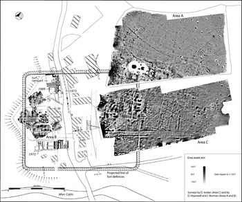
Survey in Area B identified a double anomaly coinciding with the line of the fort's western defences; although there was no obvious break at the site of the projected gate, the area immediately to the east does not contain any buildings, which strongly suggests the presence of an internal road leading to a gate. A small rectangular anomaly close to the defences might also represent part of a gate-tower akin to that found at the north gate in 1989.Footnote 3 Fragmentary traces of at least one rectangular building were identified south of the presumed road on the known alignment of the excavated buildings. A fuller picture here has been obscured by modern ferrous and garden anomalies.Footnote 4
CEREDIGION
(1) Abermagwr (SN 6688 7416): the second season of excavations explored the western half of the central and largest room of the house (Room 2) and part of the verandah (Room 7), and saw the total excavation of Room 6 which had been added to the rear of the house ( fig. 3).Footnote 5 All walling had been robbed: the wall foundations — particularly those of the north and south walls of the house — comprised substantial trenches filled with closely-packed river cobbles. A sherd of a black burnished cooking pot incorporated in the foundation trench of the north wall remains the only securely stratified find relating to its construction. In all instances the floors — including that of Room 1 which was partly exposed — were of earth. Room 2 had been provided with an off-centre slab-edged and stone-floored hearth measuring 1.1 m by 0.95 m, whilst a partly stone-built circular oven had been set against the south wall. A trench dug to examine what appeared, on a geophysical survey, to be a drain running east from the eastern ala of the house, revealed a large, rectangular pit seemingly dug with a view to adding a hypocausted room. This appears never to have been completed, the pit being filled with rubble and domestic rubbish. Fragments of flue tile, brick and imbrices from this fill suggest the probable re-use of building material from the bath-house of the long abandoned auxiliary fort at Trawscoed.
Abermagwr Roman villa: plan of the villa and the northern part of the enclosure derived from geophysical survey, showing the location of the excavation trenches. (© Crown Copyright RCAHMW)

Numismatic and ceramic evidence indicates a floruit for the building c. a.d. 270–350, although two issues of Severus Alexander, one struck in a.d. 224 and unlikely to be in circulation beyond c. a.d. 250, suggest that occupation may have begun somewhat earlier. The incidence of a few sherds of later first- to early second-century samian and coarsewares may possibly be explained by agricultural activities relating to the nearby fort at Trawscoed. Part of the slate roof over Rooms 1 and 2 collapsed during a fire sometime after a.d. 325 on the basis of coin evidence. However, later activity is evidenced by post-holes dug through the floors of Rooms 2 and 6, whilst at least one fireplace in Room 1 was built of re-used roofing slates. An unusual discovery in Room 6 were fragments of a deep convex facet- and linear-cut glass bowl or cup with several zones of decoration and of third- to fourth-century date. Examination of the double-ditched enclosure bounding the villa failed to produce unequivocal evidence of its date, although the inner ditch had been re-cut, its upper fill being used as a repository for domestic rubbish in the third to fourth century.Footnote 6
DENBIGHSHIRE
(1) Corwen, Druid (SJ 038 434): an evaluation of a small square-barrow cemetery exposed a partial section of the Roman road from Chester and Caer Gai (RR66a).Footnote 7
ISLE OF ANGLESEY
(1) Tai Cochion and Trefarthen Roman settlement (SH 4792 6560): the second season of excavation revealed a large rectangular building, 25 m long and 6 m wide internally ( fig. 4).Footnote 8 It was constructed from timber framing, with wattle and daub panels, set on a foundation of rectangular stone blocks, and incorporated an imposing 2.7 m-wide entrance with a roofed porch. There was a secondary narrow entrance in the rear wall and a portico or corridor appears to have run along the front of the building. There were fragmentary remains of a clay floor that contained hearths, ovens and stones that had been used as working surfaces. The building had been partially destroyed by fire. A roughly-paved floor was subsequently laid over the debris and the building was re-used, perhaps as a warehouse. The house was one of the higher status buildings in the settlement and occupied a prime position overlooking the landing place on the shore of the Menai Strait.Footnote 9
Tai Cochion: the rectangular building excavated in 2011. (© Gwynedd Archaeological Trust)

MONMOUTHSHIRE
(1) Caerwent, Coach and Horses (ST 470 970): three evaluation trenches were excavated in the footprint of proposed extensions. Trench C on the north-east corner of the property, close to the Roman east gate, consisted of disturbed twentieth-century deposits, showing that no sensitive archaeological remains survived above the limits of the trial excavation, a depth of 1.7 m. A rubble-filled trench, believed to be a robber trench, was revealed in Trench B, close to the street frontage on the north-west of the property. Trench A, on the south-west corner of the property, exposed a more complicated archaeological resource, which was edged on the eastern side by disturbed ground — possibly a robber trench or an even more recent disturbance associated with the recorded destruction and re-building of the standing structures. Finds from Trenches A and B were all of Roman date; the largest group of 98 sherds came from Trench A and included samian, Oxford wares, South Wales grey ware and black burnished ware dating from the second to the fourth centuries.Footnote 10
(2) Gwehelog Fawr, Llancayo Farm (SO 3629 0306): a large marching camp was confirmed during aerial reconnaissance.Footnote 11 The camp measures 500 m north–south by 400 m east–west, and encloses approximately 20.2 ha. There are only five marching camps in Wales and the Marches enclosing 12–20 ha, and only three examples greater than 20 ha.Footnote 12 As yet there is no evidence for the positions of the gateways. The camp is sited to make full use of the central and northern part of a broad alluvial terrace, which rises 22–30 m above OD, set within a wide meander of the river Usk. It entirely encloses the Gwehelog Roman temple,Footnote 13 which may have developed from an earlier Iron Age shrine. The camp lies some 3 km north-west of the legionary fortress at Usk and is the first marching camp to be recorded in Gwent. It is probably of pre-Flavian date and raises the possibility of further discoveries in this region of south-east Wales.Footnote 14
(3) Monmouth, William Jones almshouses (SO 5104 1304): several small sherds of Roman pottery were recovered during an evaluation, including South Gaulish ware and a fragment of black burnished plain-rimmed dish. These fragments were residual in nature and could not be associated with any archaeological features.Footnote 15
(4) Usk, 72 Maryport Street (SO 37792 00564): a watching-brief recorded deposits associated with the final destruction of the fortress, as well as a feature which could represent the partial closure of the fortress in the late 60s. There was a heavy deposit of stone and mortar from the destruction of a large building; this may have been part of the pre-Flavian legionary baths,Footnote 16 the demolition of which may have occurred prior to the main closure of the fortress. The final destruction of the fortress appeared to be marked by the layer of burnt clay, daub and soil in the trenches.Footnote 17 A further feature was cut into the natural, running roughly east–west across the site.Footnote 18
NEATH, PORT TALBOT
(1) Neath (Nidum), Dwr-y-Felin School (SS 746 978): excavation uncovered defensive ditches, the rampart, ovens and an internal roadway, giving a whole new understanding of the early first-century fort and the area outside its north-west gate. It also proved that the early fort was larger than its successor and that a large part of it lay outside the area of scheduled ancient monument. The defences of the timber fort consisted of a rampart and five parallel V-shaped ditches, with a combined width of about 12 m; however, it is not possible to be certain that all of them were in use at the same time. Further defensive measures included an interval tower that projected beyond the rampart. The defensive ditches were interrupted, leaving a road about 4 m wide, to allow access to the north-west gate. Sometime later a wide area of cobble hardstanding was laid over the ends of the ditches, but possibly only immediately outside of the gateway. Subsequently, a road to the west, whose route can be traced to the north-west gateway of the second-century stone fort, was laid over the hardstanding. The rampart, which ran along the edge of the innermost of the ditches, was about 6.7 m wide. The front was supported on a stone foundation made from rubble and cobbles and the back was faced with turf. In between, the core was made from a mixture of soil dug from the ditches and clay. About half way between the gateway and the corner of the fort was an interval tower. Its position was marked by the remains of three large post-holes and by breaks in the stone foundation of the rampart; the post-hole at the fourth corner was indistinct. Two of the posts were set into the front edge of the rampart but, possibly uniquely in Britain, the other two were set into the ditch on the outside of the rampart. This tower would have allowed soldiers to shoot at anyone attacking the gate. Another unusual feature was found in the face of the rampart, between the interval tower and the gateway. The line of the stone foundation had been broken to form a recess projecting into the rampart core with its ends angled inward on each side, with at the back what seems to have been a trench for a palisade. The purpose of this feature is unknown but it and a pit dug near the gateway could be related to the extracting of gravel from the earlier ditches for the later fort. Part of the internal road (via sagularis) that ran around the inside of the fort was discovered. Between it and the rampart were the remains of a cluster of seven ovens, with another lying about 12 m away. They were represented by circular bases of flagstones or cobbling enclosed by walls in the local sandstone. One of these ovens underwent refurbishment and enlargement to become a rectangular oven. The overlying soil in this area was blackened with charcoal, probably the remains of fuel raked out of the ovens. Outside the fort very few traces of activity were found, apart from a building that had already been seen during a trial excavation in the 1990s and a road,Footnote 19 which likely served the later stone-built fort, and other features including ditches and stone deposits associated with later Roman occupation of the site.Footnote 20
NEWPORT
(1) Caerleon (Isca): (a) Broadway Farm (centred on ST 338 902): part of the areas surveyed previously using other instrumentsFootnote 21 was resurveyed using a caesium vapour gradiometer, giving almost complete coverage of the ‘monumental complex’ at an improved resolution.Footnote 22
(b) Caerleon AFC (centred on ST 335 907): geophysical surveys showed a substantial linear structure on an alignment slightly oblique to that of the fortress, running approximately down the centre of the pitch. The orientation was close to that of some of the early timber buildings recorded in the area of the later parade ground.Footnote 23 The structure, although not noted in the archaeological literature, was apparently well known locally — and was described as being a stone-built water-conduit, that was ‘very solid when hit by a JCB’. This is likely to be a significant water supply leading to the fortress from the springs and small streams within the area of St Cadoc's Hospital.Footnote 24
(c) Caerleon Comprehensive School Field (centred on ST 334 905): much of the southern part of the field is made-ground, but geophysical surveys did show a slight magnetic anomaly corresponding in location to the earthwork feature previously identified as a track.Footnote 25 It is possible that the variable depth of fill over the earthwork allowed its expression in the magnetic survey. In the remainder of the field, most geophysical anomalies could be identified with drains running downslope from the school campus. Anomalies interpreted to be of more ancient origin were restricted to several positive linear magnetic anomalies. The westernmost examples, a paired set of linear features extending almost east–west down the slope, were probably small ditches flanking a narrow trackway — somewhat similar to features recorded on the golf driving range to the south-east. None of these linear features was conclusively Roman, but none showed a distinct relationship to any aspect of the post-medieval landscape. Between the drains in the eastern part of the field was a very strong positive resistivity anomaly, approximately 4 m square, indicative of a buried masonry or concrete structure. The intensity and clarity of the anomaly contrasted with those of all the Roman archaeological features within the surveys and suggest it was very shallow. An interpretation as a relatively modern feature is therefore preferred.Footnote 26
(d) 9 Lodge Road (ST 33635 90922): a watching-brief did not reveal any structural remains although some features and possible occupation levels suggest that significant Roman remains lie beneath or close to the development site. The contexts which were entered, only to a depth of 0.5 m below ground level, produced a significant assemblage of Roman pottery.Footnote 27
(e) Southern canabae (centred on ST 338 902): evaluation excavations explored several structures within the recently discovered complex of monumental buildings between Broadway Farm, the amphitheatre, and the river Usk.Footnote 28 Nine trenches were opened across an area of approximately 5 ha. They showed that the remains of the Roman buildings are remarkably well preserved just below the modern ground surface. Four of the trenches were located around the very large courtyard structure closest to the river, including two in the courtyard itself. These demonstrated that the pre-Roman land surface sloped gradually towards the river, but that the course of river itself must have been some distance further east than was previously believed. The tegula wall exposed in the 2010 test-pits was shown to be the external wall of a row of buildings that lay parallel to the river and could have been associated with a quay that has since been eroded away. A roadway passed between these buildings and a corridor-like structure that is thought to be the front wing of the large courtyard building. A fragment of a monumental inscription bearing the letters AVG is possibly part of an imperial dedication from this part of the complex. Further walls constructed with brick and tile were found in other locations, and a structure located on the main axis through the courtyard had been built entirely with clay-bonded triangular tiles. The courtyard itself was provided with a cobbled surface, into which pits and post-holes had been cut. The remaining five evaluation trenches were located to investigate other structures within the complex. These revealed part of two basilica-like buildings whose rooms and corridors had been provided with opus signinum floors and painted wall plaster, a disturbed hypocaust, open courtyards, and buildings that could have served as workshops. Numerous segmented circular bricks demonstrate the use of brick columns in parts of at least two buildings. Several drains were discovered running beneath these buildings and in one instance a drain outlet was found within a step into a building from which water would have simply poured into the adjacent open space. One end of a lead pipe, which presumably supplied fresh water down slope to the main courtyard structure, terminated with a circular plate that still contained the nails with which it had been attached to a tank of some kind. The trench overlooking the main axis of the large courtyard structure produced the remains of a collapsed barrel vault, constructed of courses of tufa and sandstone voussoirs, which had collapsed into the room below. This discovery, together with the edge of a tessellated floor uncovered at the end of the same trench, indicates that several of the buildings in the southern canabae complex were very elaborate indeed.Footnote 29
(f) The Retreat, Isca Road (ST 34436 90140): archaeological work during groundworks for an extension revealed that substantial Roman stonework survived on the site. During external excavations a line of very large conglomerate blocks was revealed which may have been the uneven but substantial foundation for a timber-framed building. Close to this was what appeared to be an industrial area of burned soil which was associated with a small square stone-paved area. A very substantial Roman structure was exposed during the removal of internal walling in the south-eastern room of the standing house. The building was associated with disturbed flooring on the south with a narrow drain built against it on the north. To the south-western side of the structure, a large fawn-coloured, bevel-edged, sandstone block may have been the base for a column. A cobbled surface exposed in the same room ran under the eastern wall of the standing house towards Isca Road. The construction and depth of the make-up beneath the cobbles suggest that this may have been the Roman road, which the modern road follows.Footnote 30
POWYS
(1) Brecon Gaer (SO 002 297): geophysical survey around the periphery of the fort revealed significant extramural activity along the road leading from the fort's northern gate, but only patchy traces of activity outside the south and west gates, while the flat field to the east of the fort was virtually featureless. Small-scale test pitting, taken down to the top of any surviving archaeology, supplemented by augering, demonstrated that the geophysics were misleading on the east side of the fort and that there were archaeological levels across much of the field, confirming what had previously been implied by metal detecting. On the south side, where the defences lie back from the lip of the river terrace, and the gently sloping ground appears favourable for settlement, only intermittent Roman activity was revealed, and on the west side of the fort virtually nothing showed up. North-east of the fort a small area was subjected to further geophysical survey, and test pitting provided some indication of the extent of the vicus to the east of the road leading northwards from the fort.Footnote 31
(2) Broad Heath, Romano-British enclosure (SO 3420 6347): aerial reconnaissance in April 2011 revealed very clear cropmarks of the enclosure ( fig. 5). These were clearer than had been seen on any previous occasion and add considerably to the published plan.Footnote 32 The main 103 m by 81 m enclosure can be seen to be rectangular, regular on three sides but with an angular north-east corner; it encloses 0.8 ha. The cropmarks have also clarified a main square inner enclosure, 38 m by 43 m, and demonstrate that this sat within a larger, concentric square enclosure 57 m across. Both the main outer enclosure and the inner enclosure have simple gateways in their eastern sides, while the main outer enclosure may also be broken by a narrow gate on its northern boundary. The cropmarks have also clarified the western edges of at least two rather irregular sub-rectangular enclosures to the south-east of the main site, the northern one 54 m long north–south, and the southern one some 49 m long, one overlapping the other. Some 72 m south of the main enclosure, and lying between it and the Hindwell Brook, are three sides of a further 32 m-square enclosure with rounded corners and slightly irregular sides. Cropmarks show one or two other lengths of ditch in the field, particularly a curving and angular pair of incomplete ditches outside the south-eastern corner of the main enclosure.Footnote 33
Broad Heath: air photo mapping of the Broad Heath enclosure cropmarks. Letters A–C indicate the positions of the original 1997 excavation trenches. (© Crown Copyright RCAHMW, licence no. 100017916, 2012)

(3) Llanfihangel Cwmdu, Pen-y-gaer vicus (SO 168 219): excavations identified at least three masonry structures, associated with separate phases of activity.Footnote 34 The nature and extent of the buildings remains uncertain, but a hearth in the earliest building could indicate domestic use, while the later structures may have had a more industrial function, and possibly may have been workshops associated with a walled enclosure. There was plentiful evidence for smithing taking place close by.Footnote 35
(4) Llanyre, Castell Collen vicus (SO 055 628): test pitting beyond the eastern and southern defences of the fort provided broad indications of the extent of the vicus on the river terrace of the Ithon, spreading down onto the valley floor.Footnote 36
(5) Montgomery (SO 21 97): a hoard of 4,854 base silver radiates was found by metal detection. The coins range from Gordian III (a.d. 238–44) to Tetricus I and II (in Gaul, a.d. 271–4), closing around a.d. 273–4, shortly before the end of the Gallic Empire issues. The hoard was contained in a pot, lacking neck and rim but probably a jar, of orange fabric akin to Severn Valley ware. Fieldwork established that the pot had been placed in the ground just inside the later of two successive sub-rectangular ditched enclosures.Footnote 37
(6) Welshpool, Smithfield (SJ 2296 0746): excavations re-examined the site where an important collection of Roman metal vessels was discovered during the excavation of a service trench in 1959.Footnote 38 The service trench was reopened, together with the adjacent trench excavated by George Boon in 1960. The backfill of both trenches contained small fragments from the vessels. The service trench had cut the southern side of a previously unrecognised elongated pit, although it is unlikely that this was associated with the finds. The records indicate that the Roman artefacts were concentrated in a relatively small area and the new evidence implies that the ironwork lay within a feature that had been cut shallowly into the subsoil. It seems likely that the finds were buried within a shallow pit which was disturbed in its entirety by the workmen in 1959. The recent excavations failed to reveal any evidence for associated structures or deposits, or provide any stratigraphical link to the other Roman features on the site.
The other features of Roman date were generally not closely dated owing to a lack of chronologically diagnostic finds. The earliest features appeared to be associated with agricultural activity and may represent part of a field-system revealed by a series of gullies that could be contemporary with traces of plough-scarring of the subsoil surface. Some of the gullies were later replaced by rows of posts, which presumably formed a fenced boundary. These boundary features were later cut by a ditch running north-west to south-east, towards the Lledan brook, which produced the only datable pottery, although this showed a wide date range from the late first or early second century into the fourth century. Collectively, these features indicate the presence of some form of Roman settlement in the immediate area, although the excavations produced no evidence for any structures.Footnote 39
SWANSEA
(1) Swansea, former David Evans store, Princess Way (SS 65601 93122): two sherds of residual Roman pottery were recovered from west of the castle defences. One sherd came from a jar with an inturned rim, probably from the Usk kilns, with a suggested mid-first-century date. The second was a thin, abraded slither of a samian mortarium, of which only the inner surface survives, probably East Gaulish from Rheinzabern.Footnote 40
NORTH OF THE ANTONINE WALL
MORAY
(1) Clarkly Hill (NJ 131 675): geophysical survey and excavationFootnote 41 revealed a long-lived later prehistoric unenclosed settlement with Roman contacts. Further denarii from the hoard, which had been scattered in antiquity, were recovered. Other finds included a trumpet brooch and an extensive range of Iron Age material.Footnote 42
PERTH AND KINROSS
(1) Inchtuthil (NO 125 397): detailed geophysical survey added considerably to earlier work.Footnote 43 Resistivity survey confirmed that a rectangular enclosure on the promontory has a ditch on only three sides, and is thus unlikely to be a camp.Footnote 44 The large camp south of the fortress showed dense pitting across the interior, while a probable third barrack was identified in the ‘officers’ compound’ to the east.Footnote 45 High-resolution survey produced great detail of buildings within the fortress, including the hospital ( fig. 6), principia and fabrica, and revealed that the oval feature outside the north-east gate is unlikely to be an amphitheatre; it is a conflation of two separate anomalies.
(2) Ardoch, Blackhill (NN 840 108): assessment of extensive tree-fall damage within the area of the temporary camps revealed no archaeological features.Footnote 46
High-resolution magnetometer survey of the Inchtuthil hospital. (Courtesy of Dr D.J. Woolliscroft)

(3) Castle Craig (NN 97604 12714): excavationFootnote 47 of this hillfort revealed a previously unknown broch which appears to have been deliberately dismantled. As with many other southern brochs, finds point to strong links with the Roman world.Footnote 48 Among the rich assemblage from the small trenches were an intact copper-alloy trulla and sherds of a tubular-rimmed glass bowl.
STIRLING
(1) Malling (NN 564 006): resistivity and magnetometry surveysFootnote 49 clarified the layout of the fort ( fig. 7). The ditches run to the present loch shoreline without turning, suggesting the eastern end has been eroded. No cross-ditch correlates with kinks in these east–west ditches, dismissing arguments for an annexe here; the irregularity perhaps suggests a change of plan during construction. It seems this large fort (c. 3.6 ha (8.9 acres) over the inner ditch) faced east, with a large praetentura and a much-reduced retentura. An outwork ditch provided additional defence on the eastern part of the northern side, while a ditch running from the south-west corner may represent an annexe. Some pits are visible within the temporary camp south of the fort.
Magnetometer survey of the fort at Malling. (Courtesy of Dr D.J. Woolliscroft)

FALKIRK
(1) Camelon, Glasgow Road (NS 8640 8072): a large area over the south-east corner of the ‘south camp’ was evaluated prior to development, with two areas excavated more substantially.Footnote 50 The larger of these lay east of the Antonine annexe and uncovered a multi-phase field-system of contemporary date. This consisted of a series of overlapping boundary ditches set on two alignments, with pits and a possible cremation burial, all heavily truncated. An earlier phase of large pits, field ovens and a putative timber post-built structure may be Flavian in date. The second area provided a section through the south defences of the Antonine fort. The earth bank of the rampart survived to a height of 1.3 m and had been modified to insert a front wall of clay-bonded boulders. At the same time the dimensions of the rampart were substantially increased and the inner ditch filled in. This ditch was already redundant as evidenced by a thick layer of peaty material that incorporated much leatherwork, including some 90 shoes. Subsequently the rampart facing collapsed and it appears that a metalled road crossed the area. Further ditches were observed throughout the area of the evaluation, both north and south of this rampart. To the south they include probable Flavian trenches, tying in with those identified by Maxfield,Footnote 51 as well as the outer ditches of the Antonine annexe. Those to the north suggest a previously unrecognised division of these enclosures. Apart from the stone foundations of a rectangular building near the eastern rampart, only occasional post-holes from internal features were seen.
THE ANTONINE WALL
FALKIRK
(1) Kinneil (NS 9774 8037): (a) excavationFootnote 52 found no convincing trace of a spur road heading from the fortlet to the supposed line of the Military Way some 130 m to the south,Footnote 53 and suggested that this latter is actually an eighteenth-century road. It seems more likely that the Military Way ran nearer to the Wall and close to the rear of the fortlet, avoiding the obstacle of the Deil's Burn to the south. (b) Geophysical surveyFootnote 54 showed that the fortlet had two ditches on the western side but only one on the more defensible east; the terminals turned in at the southern gate.Footnote 55
(2) Weedingshall, Falkirk distillery (NS 925 794): evaluationFootnote 56 immediately south of the Wall found no Roman remains; this low-lying area would have been very damp.
(3) Mumrills (NS 918 794): further systematic fieldwalkingFootnote 57 over the fort recovered useful spatial patterning in the range of ceramics. Coarseware and mortaria were concentrated in the barracks in the retentura, while samian was found most often in the central range and towards the end of the retentura barracks, around the centurions’ quarters. Amphorae sherds were widespread across the fort.
(4) Laurieston, 74 and 76 Grahamsdyke Street (NS 9138 7952): an evaluationFootnote 58 at 74 Grahamsdyke Street found remains of a Roman period turf wall running north–south just behind the Wall, and probably butted against it. Earlier work at No. 76 in 2008 (not previously reported) had found a similar turf feature and a north–south gulley, along with Roman pottery. This is probably part of extensive settlement activity to the west of Mumrills.Footnote 59
(5) Rough Castle (NS 8431 7991): excavation of part of the Ditch in front of the fortFootnote 60 showed that its fills had been stripped out and its form modified during drainage work in the 1960s.
(6) Castlecary: (a) (NS 7900 7818): excavationsFootnote 61 just beyond the north-east corner of the fort showed that the Wall did not join directly to the corner but lay some 10 m to the south, and probably fitted behind a wing wall. No defensive pits were found on the unusually wide berm, but a spur ditch running north–south between Wall and Ditch cut off access to the fort's northern defences.Footnote 62 A shelf on the southern lip of the Ditch supported a well-preserved drystone revetment. The upcast mound to the north, of solid clay with traces of stone revetments, showed two phases, suggesting a narrower primary ditch defended the fort before the Wall-building programme reached the area and the ditch was expanded. (b) Allandale Football Ground (NS 7986 7868): a watching-briefFootnote 63 showed that the upcast mound survived well, though the rampart had been terraced away in the 1920s.
SOUTH OF THE ANTONINE WALL
EAST LOTHIAN
(1) Inveresk: Brunton Wireworks / Musselburgh Primary Health Care Centre (NT 3428 7224): area excavationFootnote 64 at the base of the slope immediately north of the fort revealed a complex sequence of activity: (i) a series of Iron Age inhumation and cremation burials (second century b.c.–first century a.d.); (ii) Roman period (Antonine) cremations and six inhumations (four decapitated; fig. 8), as well as the burial of a horse; (iii) part of the cobbled foundations for a ?rampart defining three sides of an enclosure;Footnote 65 (iv) the ditches of a field-system;Footnote 66 (v) a post-built structure within the enclosure, but post-dating its slighting by the field-system; (vi) a midden deposit, rich in finds, which appears to have been cultivated.Footnote 67
Decapitated burial, Inveresk. (Courtesy of CFA Archaeology)

SCOTTISH BORDERS
(1) Easter Langlee (NT 52060 36105): survey of aerial photographsFootnote 68 revealed linear features in the area where quarrying had exposed and destroyed a structure composed of Roman stonework.Footnote 69 Trial-trenching established that parts of this complex still survive beyond the quarry.
(2) The Rink (NT 48 32): a stray find of a fragmentary wagon-fitting comprising an eagle-head emerging from a flower bud and gripping a berry ( fig. 9).Footnote 70
Eagle-headed wagon fitting from the Rink (Scottish Borders). (© Crown Office)

DUMFRIES AND GALLOWAY
(1) Carzield (NX 97 82): a spread of findsFootnote 71 north of the fort, including samian ware and coins consistent with an Antonine date, indicate activity in this area.
SOUTH TYNESIDE
(1) South Shields fort (Arbeia) (NZ 365 679): excavation continued in the same 10 by 17 m area, 20 m south-west of the south angle of the fort, as described last year.Footnote 72 A ditch terminal, counterpart to that of the outer ditch described last year, was found, projecting slightly from the south-east section and cutting through the roadway found in 2011 heading towards the south angle of the fort, leaving a causeway only 2 m wide. This possibly represents a narrowing of a causeway that originally carried the road through the ditch. The ditch itself showed no tendency to turn around the south angle of the extended fort, so it may have carried on to form the south-west side of an annexe attached to the south-east side of the fort.
South-west of the outer ditch were two pits separated by an upstand of clay, through which a channel 0.7 m wide linked them. The north-east pit, cut by the ditch, was rectangular, 2.8 m long by 2 m wide and 0.25–0.43 m deep. The south-west pit was irregular in shape, 4 m long by 1.4–2 m wide and 0.33–0.43 m deep. These pits were associated with some metalworking process — a small metal crucible and the broken fragments of further crucibles were discovered in the fills along with an area of burnt clay in the south-east corner of the rectangular pit.
These features appeared to be stratigraphically earlier than the road (and possibly the stone building) described last year. They contained pottery which on Hadrian's Wall is no earlier than the mid-third century in date (notably Campanian ‘black sand’ amphora), suggesting that the road and ditch arrangement might not have come into being until the late third/early fourth century (in contrast to the Severan date suggested last year) and that there was possibly still activity in this part of the vicus at that time. The pottery in the ditch indicated that this had remained open until the late fourth century.Footnote 73
NORTHUMBERLAND
(1) Vindolanda (NY 769 663): (a) following on from the 2010 work a fourth season of excavations within the north-west quadrant produced three principal findings which will have a major bearing on the future interpretation of the site. The first is that the original third-century barracks in this area were of a more traditional nature than those encountered in 1980Footnote 74 ( fig. 10). Rather than an initial build of or very quick conversion to chalet-type construction as encountered by Bidwell (namely free-standing structures) those in the north-west quadrant were constructed in the more traditional style of earlier periods and were occupied from c. a.d. 213 to c. a.d. 270–278 before being demolished and replaced. In the fourth century the foundations of the earlier barracks were covered in largely free-standing ‘chalet’-style buildings similar to those uncovered in the north-east quadrant at Housesteads.
Vindolanda: plan of c. a.d. 213 barracks in the north-west quadrant of the stone fort.
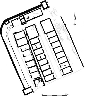
The second discovery was that the bottom of the street between the third-century barracks may have been guarded or adorned by a gateway, raising the question of whether or not there was a ‘gated’ or segregated community within the fort itself at that time, possibly a detachment of a different unit (other than the Fourth Cohort of Gauls). The physical evidence for the possible gateway consisted of the remains of four responds protruding into the street from either side of the southern barrack rooms, perhaps closing off the junction to the via principalis.
The third principle discovery from the fort excavations was the remains of a further nine circular huts, situated directly below the c. a.d. 213 barracks and above the earlier Antonine barracks. These were generally in a poor state of preservation but enough survived to indicate the possible layout of the structures in this quadrant of the fort. It is increasingly clear that the roundhouse period at Vindolanda (Severan in date) was very extensive and that buildings were constructed in neat rows of five set out back to back, with room for a street between. The very small quantities of material culture recovered from the circular huts and associated contexts may suggest non-military habitation.
Directly below the foundations of the circular huts were the remains of the Antonine fort's barracks. Unlike the later third- and fourth-century fort the Antonine fort was constructed facing south. Each barrack room in the Antonine period was found to have had its own hearth in the middle of the room, a marked difference from the later third-century barracks, some of which were furnished with fireplaces set into the walls adjacent to the doorways into the rooms.
(b) Excavations in the extramural settlement focused on the area immediately south and west of the third-century bath-house. Here the foundations of a large mid-second-century defensive stone wall were uncovered that had been constructed on a stout clay rampart immediately to the west of the later baths. This defensive line was re-enforced by a deep ditch on its western side. The ditch and wall were certainly out of use by the time of the Severan fortlet (to the west of the circular huts) and the subsequent vicus structures were placed over the demolished/filled in remains.Footnote 75
CUMBRIA
(1) Knockupworth, Beaumont Parish (NY 3720 5688): excavations in 2009 and 2010, in advance of road construction revealed the remains of both the Turf and Stone Walls of Hadrian's Wall, the north and south mounds of the Vallum, and the Vallum ditch. The slighted Turf Wall comprised a shallow, 3.45 m wide deposit of dark sediment, aligned broadly north-west/south-east, truncated by the Stone Wall, which had been built upon it. The latter survived to a maximum of two courses (0.35 m) high, the foundation course consisting of flat, irregular slabs of yellowish-brown sandstone, faced to the south-west, enclosing a clay-bonded rubble core. Three adjacent blocks of a similar fabric, on the Wall's south-western face, were the only remains of the second course of stonework. The Wall survived in two distinct lengths, one being 9.8 m long and the other 2.75 m long. It had a maximum width of 2.7 m, with none of the north-eastern face surviving; this has probably eroded over time into the River Eden, as the Wall was on the lip of a steep cliff down to the river.
The Vallum (ditch and north mound) was sampled in two places; the south mound was only encountered at one location, and it was only there that the depth of construction necessitated excavation of the complete profile of the ditch and the sequence of deposits within it. Where sampled the Vallum ditch had a wide, flat, U-shaped profile, and appears to have been approximately 5.8 m wide and 2.7 m deep, although it had been recut on its south side. The lowermost deposits were permanently waterlogged and predominantly comprised deliberately backfilled sediments, including a substantial dump of turves which may have derived from the slighting of the Turf Wall or the Vallum mounds.
The sections excavated through the north mound produced widely contrasting results, which appear to reflect the level of damage it had suffered. The base of the mound comprised redeposited glacial till (gravel and cobbles). In one of the interventions, the mound was 5.25 m wide and lay 9.25 m to the north of the ditch, whereas, in the other, the edges of the mound were far more diffuse, making the deposit more difficult to define confidently. It appears, though, that the mound was located 6.4 m north of the ditch and was 11.4 m wide, if dispersal by ploughing can be discounted. The possible vestiges of the south mound were also detected as an 8 m-wide deposit of redeposited glacial till, immediately to the south of the Vallum ditch, although this too may have suffered some displacement since its original deposition, or it may in fact represent the remains of a marginal mound.
At some point, the Vallum ditch had been recut on the south by a ditch with a U-shaped profile, and of similar depth to the original ditch. The recut was at least 4.1 m wide. Initially, this ditch also seems to have seen some deliberate backfilling, with a highly mixed deposit of organic material and clay-silt, containing a single sherd of second-century pottery, presumably providing a terminus post quem for this phase of activity. A period of gradual natural silting followed, represented by a complex sequence of numerous interleaving deposits. It was evident that the uppermost part of the ditch profile had been infilled during the post-medieval period and, in places, deposits associated with the nineteenth-century Carlisle Navigation Canal and the Carlisle and Silloth Railway had obscured its full width.Footnote 76
(2) Kirkandrews on Eden, Beaumont Parish (NY 3519 5901): a small evaluation trench, in advance of improvements to access on the Hadrian's Wall Path National Trail, revealed the core of the stone phase of Hadrian's Wall. This was located at the lip of the scarp slope above the River Eden, at a depth of only 0.17 m below the ground surface. It largely comprised very roughly squared red sandstone, measuring a maximum of 0.4 m by 0.17 m in size. The Wall was over 2 m wide, the south face not being located, but the north face had been affected by the erosion of the river scarp, and the insertion of steps for the Cumbria Coastal Way, so that no facing stones now remained.Footnote 77
CUMBRIA
(1) Kendal area: two denarii, two sestertii and one dupondius from Domitian to Hadrian, also one plated denarius and a, probably Roman, key.Footnote 78
(2) Maryport (Alauna), Camp Farm (NY 038 372): excavations in 2011 were designed to explore the area where Roman altars were found in pits in 1870.Footnote 79 The altars have long been considered to have been ritually deposited.Footnote 80 Truncated traces of timber buildings of beam-slot and post-in-trench construction were found, as was a fragmentary cobble surface. These features were cut by the ‘altar pits’, of which ten were excavated. One of these was undisturbed by earlier excavators. Like all of the pits, it was 1.3 m square and 1.3 m deep, filled with stone, and a 300 mm square post socket was found in the top. The other nine pits had all been disturbed by previous investigations. Seven of these had been partially excavated by earlier archaeologists who had respected the edges of the pits, partially removing the stone fill. All of these pits retained part of the original fill, and in the bases of all them were greenish stains, 300 mm square. These pits seem to have been some of the 59 excavated in 1870. Two pits retained some 60 per cent of the original fill, having been previously excavated without regard to the original cuts. In these it could be seen that the stone packing in square pits measuring 1.3 m3 was placed around posts 300 mm square, the sockets of which survived, lined with green staining produced during the decay in situ of the posts. In one of these, the corner fragment of an altar was found. This was immediately identified as the missing corner of RIB 823, an altar first recorded by HorsleyFootnote 81 at the Senhouse family seat of Netherhall in 1725 and now in the Senhouse Museum. The void from which the fragment came was of identical dimensions to the altar, which must therefore have been recovered from this pit before 1725. The altar had been re-used as part of the packing for a post. This discovery demonstrates that the story of ritual deposition should now be discarded. The altars were deposited as packing for the timbers of a very large late Roman building ( fig. 11). Possibly associated with the pits was a curvilinear ditched enclosure, in the basal fill of which an altar fragment was found.Footnote 82
Maryport site plan showing altar pits and curvilinear enclosure.

COUNTY DURHAM
(1) Binchester (Vinovia) (NZ 2102 3134): the third season of the new campaign of excavation took place in 2011 and saw continued work in both the dextral half of the praetentura, close to the east corner of the fort, and in that part of the vicus lying beyond the south-east defences.Footnote 83 Inside the fort further examples of the large pits typifying the latest phase of activity were found, in some cases lined with stone and/or clay; one exceeded 3 m in diameter. There was no discolouration of the sides of these pits to indicate their function. Their homogeneous soil fill, along with contemporary deposits over surrounding areas, contained large numbers of cattle bone fragments — principally skulls, jaw bones and hooves. This suggests that the pits, and neighbouring platforms of rough paving, were used for the slaughtering and processing of animal bone (and possibly hides) like the pits found on the praetorium site during excavations in the 1970s and 1980s and dated to the fifth century.Footnote 84 Another pit cut into the clay of the fort rampart appears to have been used to collect and store water for use in these processes.
Further details of the underlying building are emerging with clear evidence in the north-west outer wall of two periods of construction separated by a period of abandonment. Traces of what may have been the original south-east outer wall of the building are beginning to emerge in the intervallum area, giving it a width of c. 11 m. The well-preserved base of a bread-oven set into the back of the south-east rampart was excavated.
In the trench outside the fort to the south-east a 40 m-long stretch of the latest surface of Dere Street has been revealed along with the outlines of several buildings fronting onto its north-east side. Lying closest to the fort and immediately adjacent to a side-street surfaced with very large paving slabs was a small, rectangular ‘strip-building’, measuring 5 by 13 m with walls of neatly dressed masonry. Adjacent to this building and separated by a gap of less than 0.40 m there stood a second building with similar dimensions. Stone-robbing had removed large sections of its walls but even so it was plain that this building was of inferior, and very probably later, construction than its neighbour.
A third building continues beyond the confines of the trench both to the east and to the south. Its walls are of superior quality to those of its neighbours both in terms of construction and appointments. Two rooms lay within the trench with a porch-like structure attached to the frontage apparently of later date. Wall-plaster survives in situ within the latter while a patch of waterproof concrete still adheres to the face of one of the walls in the larger room. The interior of each room was fully occupied by a large pit lined with flat stone slabs. Their fill was similar to those of the pits found inside the fort and similarly produced large quantities of animal bone.
Immediately east of the trench a depression in the field surface denotes the spot where Victorian excavations uncovered a circular hypocausted chamber.Footnote 85 This is almost certainly part of the regimental bath-building and the rooms described above seem likely to belong to the same building. Assuming this followed the usual row-type plan and extended northwards, this would explain why the two neighbouring buildings were so small, there being only a narrow strip of ground between the baths and Dere Street.
A notable find this season was a fragmentary inscription found re-used as paving material at the north end of the vicus trench (see Inscriptions No. 6).Footnote 86
(2) Chester-le-Street, 1 Lindisfarne Avenue (NZ 4276 5516): limited exploratory excavation revealed the remains of a very substantial masonry building, almost certainly the regimental bath-building long thought to have stood in this area.Footnote 87
NORTH YORKSHIRE
(1) Aldborough (Isurium Brigantium) (SE 40609 6632): the magnetometer survey continued in two areas: (a) one in the north of the town revealed detailed information about the buildings in this area and possible internal/earlier defences, and more importantly seemed to indicate that there was no north gate to the town. (b) Studforth Hill: magnetometer survey confirmed the presence of an amphitheatre, as well as revealing that the possible ‘stadium’ was actually a well preserved section of the defensive circuit. It also showed other features which suggest that the amphitheatre may have been re-used as a defensive site in the medieval period.Footnote 88
For the first time Ground Penetrating Radar (GPR) was tested on the site.Footnote 89 It was used in the churchyard to see whether features from the Roman town could be identified beneath the graveyard. Maps from Eckroyd Smith's Reliquiae Isurianae showed the presence of a possible forum wall to the north of the church. The GPR survey covered the western half of the churchyard, and was successful in identifying earlier walls, which from their orientation and layout appear to be those of the forum.Footnote 90
(2) Hebden area: 33 silver denarii from Vespasian (a.d. 69–79) to Marcus Aurelius (a.d. 161–180).Footnote 91
(3) Kilnsey, Chapel House Wood (SD 975 651): preliminary surveys of this area were carried out by Arthur Raistrick in the mid-1960s and identified a Romano-British hut circle with enclosures and associated fields.Footnote 92 Detailed field recording has identified significant differences between two main areas of settlement at the heart of the extensive complex of surviving earthworks. The northern settlement area contains Raistrick's ‘Romano-British hut circle and enclosures’ and is surrounded by a low stone bank around 1.5 m in width. The internal structures themselves are more elaborate than was originally thought, comprising oval or sub-rectangular elements at the ends of two substantial rectangular stone foundations. Pottery from this part of the settlement comprises a small number of Roman fine and coarse wares, mostly heavily abraded.
The southern settlement area comprises building platforms on either side of a hollow way, which leads past a single enclosed area containing a sub-rectangular structure. Excavation of the largest platform has revealed a semi-circular or D-shaped faced bank of stones, with the curved side recessed into the hillside, leaving a gap of about 0.7 m. The straight side faces out across the valley and is marked by a line of paving along the break of slope. Finds include a large quantity of domestic animal bone and an Aucissa brooch. The small amount of pottery from this area includes a very thick rim sherd of native ware. Evidence for metalworking includes hammer-scale, fragments of a crucible and splashes of lead. Calibrated radiocarbon dates lie predominantly in the first century b.c. and second to third centuries a.d. respectively, and suggest continuity from the late Iron Age into the Roman period.Footnote 93
YORK
(1) York (Eboracum): (a) Heslington East I (SE 641 509): the fourth season of excavationFootnote 94 identified evidence for Bronze Age activity, including some cremations. However, the majority of activity here belongs to the Roman period and includes significant landscape features such as terracing and boundary ditches, the alignment of the latter reinforced, in one case, with two north–south inhumations. A third- to fourth-century masonry building was set within this landscape, together with a second, timber-framed structure, a cobbled trackway and a 3 m-deep, stone-lined well almost at the summit of Kimberlow Hill, on the southern slope of the York moraine.
To the west, a substantial rectangular cobbled foundation, initially revealed in 2008, was investigated further and is now interpreted as footings for a tower mausoleum. Two associated adult inhumations lay just outside this tower structure, with several further infant inhumations in the vicinity.Footnote 95
(b) Heslington East II (SE 6430 5100): excavation revealed a complex sequence of archaeological features stretching back to at least the Middle Bronze Age and including a small Iron Age farmstead. As at Heslington East I, the majority of features were dated to the Romano-British period, but the area appears to have lain outside the main focus of settlement on the site. Evidence for land management was frequent, with complex re-cut ditched enclosure systems across much of the excavated areas. The excavation also revealed continuing evidence for exploitation of the natural springs, first recorded for the Bronze Age, ranging from rough unlined pits to formal wells. Some of the latter included wattle linings, whilst others employed cobble, clay and timber posts to support the unstable natural sides. The waterlogged conditions provided a rare opportunity within a rural setting for the preservation of organic objects, woodworking technologies and environmental evidence, which are all in the process of conservation and assessment. Two crop-driers were also excavated. Assessment of the pottery suggests the presence of material from the late first century a.d. through to the late fourth or early fifth century, although the majority of activity appears to have taken place in the third to mid-fourth centuries.Footnote 96
(c) Holgate Villa, Holgate (SE 59507 51315): an evaluation was carried out within an area that has previously revealed burials of Romano-British date. However, no burials were encountered; the trenches revealed a soil horizon, a ditch and a pit of Romano-British date. Occasional fragments of disarticulated human bone were present within the excavated features.Footnote 97
EAST RIDING OF YORKSHIRE
(1) Gas Storage project, Boynton and Rudston parishes: (a) Low Caythorpe (TA 1235 6792 and 1221 6783): Roman period settlement was principally recorded in two areas: Area 1 (centred on TA 1235 6792) and Area 2 (centred on TA 1221 6783), alongside the pipeline easement excavated in 1992. Much of Area 1 occupied a south-facing slope, formed by successive thick colluvial deposits, beneath and between which were sandwiched separate horizons of archaeological activity: the earliest horizon spanned the early Neolithic to the early Iron Age; the next, the Iron Age and early Roman periods; while that succeeding contained features of Roman and Anglian date, being sealed by colluvium associated with medieval agriculture. At the base of the slope, where the ground was more level and dropped only gradually to the Gypsey Race to the south, colluvium was absent, and features of all phases intercut here; this was also the case in Area 2, which lay on the same relatively level ground.
Late Iron Age/early Roman activity was principally represented by several major north–south boundary ditches, around 60 m apart in Area 1. The partial remains of two roundhouse drip-gullies lay between two of the ditches, while a number of chalk surfaces and pads, and a lesser number of post-holes, are assumed to represent further associated structural activity. A later phase of narrower ditches or gullies on two predominantly ENE–WSW alignments cut across the north–south ditches, extending across the slope in Area 1 and crossing the northern end of Area 2. Contemporaneous isolated burials were recorded in both excavation areas. Pottery recovered was principally locally-produced handmade coarsewares, with smaller quantities of wheelthrown greywares of probable second- or early third-century date and occasional samian sherds.
Deposition of a major colluvium was followed by an intensive phase of Roman period activity recorded in both areas. A series of parallel shallow gullies, repeatedly redefined, crossed the slope at the eastern end of Area 1, repeating the alignment of linears established at the end of the previous phase. On the slope in the centre of the area lay an enclosure, up to 35 m wide and over 50 m long, defined by a series of successive intercutting narrow ditches or gullies; the north-east corner of the enclosure funnelled outwards into a ditched trackway leading to the north. The interior of the enclosure appeared devoid of any structural activity and it may have been for stock.
Cutting across the enclosure were a number of successive major boundary ditches, running along the slope for lengths of up to 170 m. The ditches marked the northern extent of a settlement which ran east–west along the lower-lying ground at the base of the slope, with ditched enclosures, and subdivisions thereof, being recorded. While only the very northern edge of this complex of enclosures was recorded in Area 1, in Area 2 the full width of the settlement was transected by the pipeline corridor, here comprising two principal enclosures, 30 m and 60 m across, each subdivided. Structural elements such as post-holes, stone layers and a small stone-lined oven were recorded; while the presence of timber buildings is suggested, no coherent building plan could be determined. Pottery recovered from the settlement enclosures and associated boundary ditches ranged in date from the third century through to the late fourth or early fifth century. Subsequent settlement activity of Early to Middle Saxon date was recorded in both areas.
(b) Rudston (TA 1147 6730): small numbers of Roman features, principally boundary ditches, were also recorded in some of the other areas investigated on the route of the proposed pipeline south of the Gypsey Race. Of particular note is a small ditched enclosure in Area 5B, into which had been cut a grave capped by a layer or low cairn of stone.Footnote 98
(2) Kilham, Pasture Close, south side (TA 0572 6420): an evaluation and subsequent excavation was undertaken prior to residential redevelopment on the site of former allotment gardens. Archaeological features included ditches, pits and post-holes. The post-holes did not form any definite buildings, but appear to represent fences and screens around some of the pits. The majority of archaeological features contained undiagnostic, locally produced handmade pottery, which may have dated to the later prehistoric or Roman periods. Only very occasional sherds of clearly Roman period pottery were recovered, which may indicate that the majority of the handmade pottery was pre-Roman, or that local ceramic sources remained sufficient into the Roman period.Footnote 99
(3) Middleton: seven silver siliquae from Julian Augustus (a.d. 360–363) to Honorius and Arcadius (a.d. 395–402).Footnote 100
(4) North Dalton: eight silver siliquae from Julian Augustus (a.d. 360–363) to Honorius and Arcadius (a.d. 395–402).Footnote 101
(5) Sancton Hill, wind farm site (SE 91766 39742): evidence from aerial photographs indicates that the development area contains a series of rectangular enclosures, field-systems and trackways. Field-walking and metal-detector surveys in the area of the cropmarks have recovered a few pieces of late Iron Age metalwork and a substantial quantity of Roman coins, brooches and other objects. These finds suggest the presence of a settlement which originated in the later Iron Age, but which was also occupied during the Roman period. Further south, aerial photographs show a curving length of ditch, which may be part of a large ring-ditch of prehistoric date. Geophysical survey of the proposed development footprint has identified a number of anomalies, including a possible double-ditched trackway and some early field boundaries. The evaluation was focused over five areas, with trenches placed to target geophysical anomalies as well as to sample areas without geophysical anomalies. A pit in Trench 6 in Area 3 contained a single sherd of Roman pottery (greyware of second- to fourth-century date) in its fill and the excavation of Trench 8 within Area 2 revealed a hollow-way possibly running towards cropmarks to the west of Sancton Hill Farm.Footnote 102
(6) Near Selby: 201 silver denarii in two greyware beakers from Mark Antony (32–31 b.c.) to Commodus (a.d. 180–192).Footnote 103
(7) Withernwick parish, land between Cowden Lane and Aldbrough Road (TA 2130 4096): following on from geophysical survey, eleven trial excavations were carried out in advance of the proposed construction of a wind farm, Trenches 6 and 10, in the area of one turbine and under the planned sub-station, targeting particular concentrations of features. A small number of features recorded in outlying trenches were potentially of Iron Age or Roman date, though the majority of the Roman features were recorded in Trench 6, where ditches defined an east–west trackway, with contemporaneous enclosures to both north and south. These would have lain on the western edge of a small settlement site, the majority of which extended to the east, outside of the excavated area. Pottery recovered from the fills of the features was principally handmade late Iron Age/early Romano-British local wares, though there were occasional fragments of finer regional Roman pottery types. Two fragments of Roman ceramic building material were also recovered. Features representing an early Saxon phase of settlement were recorded in both Trenches 6 and 10.Footnote 104
LEEDS
(1) Roundhay, Elmete Caravan Park (SE 339 373): an evaluation by geophysical surveyFootnote 105 and trial-trenchingFootnote 106 was carried out on a 7 ha site in advance of its proposed development as a graveyard. The south-facing site, immediately south-east of Roundhay Park, had been terraced when the former caravan park was created. This had resulted in the partial truncation of two square ditched enclosures, one within the other, each defined by substantial V-shaped ditches. The fills of the ditches produced late third- and fourth-century pottery, predominantly Dalesware. The outer enclosure is about 110 m square, whilst the centrally positioned inner enclosure is just 45 m square. The form of the enclosures, coupled with the nineteenth-century discovery of a Roman altar in the area, fuelled speculation that they may represent a shrine. The evaluation findings have not, however, been able elucidate on this possibility.Footnote 107
KIRKLEES
(1) Slack, Outlane (SE 0840 1750): excavations by the Huddersfield and District Archaeological Society (HDAS) in 2007 and 2008 uncovered a complex of conduits designed for carrying fresh water supplies to the vicus area north of the fort and heading directly towards the fort, which is now covered by the local golf club. Parts of the conduit were floored with wooden planking that has been radiocarbon dated to between a.d. 210 and 340.Footnote 108 The competent construction of the conduits in stone with overlapping capping stones sealed with clay and their direction towards the fort suggest a military design. This late dating was further supported by some of the pottery finds from the same excavations which include a large proportion of material (especially black-burnished wares) dating to the later second and early third centuries.Footnote 109 The presence of Crambeck parchment ware and Aldborough white ware dating from the third to the end of the fourth centuries suggests even later occupation at Slack. Cumulatively the evidence suggests that military occupation at Slack may have extended beyond the previously accepted end date of a.d. 120–140, possibly by a considerable period.Footnote 110
CALDERDALE AND ROCHDALE
(1) Blackstone Edge road (SD 9565 1649–SD 9895 1843): a detailed earthwork survey and investigation has been undertaken of the route of the presumed Roman road over Blackstone Edge,Footnote 111 crossing the South Pennines between Greater Manchester and West Yorkshire. The survey, encompassing the whole of the Scheduled Monument area together with additional survey blocks along its northern and western sides, was undertaken with the intention of identifying any relationships between the road and adjacent surface features. The position of all the enigmatic central ‘gully’ stones, kerb stones and other paving was also recorded to determine the road surface's current condition. The survey has identified previously unrecorded lengths of road embankment and terracing along the West Yorkshire section of the road, as well as sections of paving, including central gully stones, of a similar construction to those on the better known western half of the monument. Although previously considered to be Roman, the age of the road has been widely debated and it has been suggested that the visible paving could be the result of the turnpiking of an earlier route.
LANCASHIRE
(1) Kirkham, No. 38 Dowbridge (SD 43272 31832): a watching-brief was undertaken during groundworks for a house extension.Footnote 112 The works revealed a continuation of the asymmetric-profiled ditch (fossa punica) recorded in 1994Footnote 113 and interpreted as the perimeter of the third temporary camp (phase 1.4), dating from before a.d. 117. The ditch was also seen in 2001, immediately adjacent to the 2011 works.Footnote 114 At the south-west end of the works two shallow linear features with a stony upcast on their western sides were found. These features would lie outside the ditch of the ‘Third Temporary Camp’, but within the area enclosed by the ‘Second Temporary Camp’. It is conceivable that they represent prehistoric agriculture, but a medieval or post-medieval date is also possible. A complete profile of the ‘punic’ ditch was recorded in the western trench (Trench 2), where it was found to be 7.60 m wide and 2.20 m deep. An ‘ankle-breaker’ was detected in Trench 5. Samian from the lower fills was of first-century date; the fills also produced a greyware bowl of late first- to mid-second-century date.Footnote 115 Later ditch fills incorporated re-deposited cremated human bone associated with later first-century samian. Abandonment horizons, which produced mid-second- to early third-century coarseware, also incorporated pedalis, lydion, sesquipedalis, and/or bipedalis bricks, suggesting that a building with underfloor heating had existed near by.
CHESHIRE
(1) Middlewich, King Street (SJ 7053 6645): a watching-brief at the southern end of King Street, accompanying gas main replacement work, recovered evidence for the principal Roman road running north-west–south-east through the settlement, together with the remains of Roman structures and probable external surfaces. Small, shallow indentations in the natural subsoil, sealed by Roman deposits, may relate to the cultivation of the area. First- to third-century pottery, briquetage and daub were recovered.Footnote 116
(2) Warrington, Appleton and Thorn (SJ 6374 8374): a small evaluation trench was excavated in advance of the construction of a new front porch to a property lying on the line of the Roman road extending along the southern edge of the Mersey Valley, from Stretton in the west to High Lee and Hoo Green in the east.Footnote 117 The section affected by the porch is part of a c. 40 m-long section designated as a Scheduled Monument, although the trench, which encompassed the entire footprint of the proposed porch, revealed only deposits of probable eighteenth- to twentieth-century date. It was noted that the scheduled section, which was originally designated due to the presence of a raised section of agger, is now much reduced, particularly in the car park immediately to the north-east of the evaluated area.Footnote 118
(3) Tattenhall, Chester Road (SJ 4872 5860): following an earlier programme of evaluation in 2010, which had indicated the presence of Roman deposits, the site of a new parsonage c. 60 m to the east of St Alban's parish church was subject to a programme of strip, map and record.Footnote 119 Past observations had suggested that the remains of a Roman building might be present beneath the parish church.Footnote 120 That part of the evaluation area where Roman features were located was not excavated as it lay within the new garden area and no archaeological features were found within the footprint of the house and garage. It was concluded that any Roman activity extended for no more than 40 m to the east of the church.
LINCOLNSHIRE
(1) Bourne, Manning Road (TF 1027 2003): evaluation in the area of the Car Dyke Roman waterway and near to previous discoveries of Roman and medieval remains, including evidence of medieval pottery making, revealed a Roman gully and a couple of undated ditches. The western edge of the Car Dyke was tentatively identified, although a nineteenth-century quarry covered a large part of the area. Much of the site had previously been stripped in the 1970s–80s.Footnote 121
(2) Cowbit, Backgate (TF 2651 1785): trial trenching was undertaken prior to residential development at the site. Evaluation of the site identified remains of Roman, medieval and post-medieval date. The Roman deposits relate to domestic or agricultural activity associated with the nearby settlement. Pottery, animal bone, a triangular loomweight and wall-plaster were among the artefacts recovered. The Roman pottery assemblage would be characteristic of high status dining and if the wall-plaster is of Roman date, a building of some status may lie elsewhere in the vicinity. At the south-west corner of the site Roman deposits are likely to be associated with a small Roman settlement in the adjacent field to the south, first identified during fieldwalking undertaken in 2001.Footnote 122
(3) Fenton, Lincoln Road, Torksey Lock (SK 8381 7788): evaluation close to the known Roman pottery kilns and the Foss Dyke Canal, believed to be of Roman origin, which is located immediately to the north. A few ditches, pits and a dumped deposit were revealed; although undated, they were thought probably to be Roman and were sealed beneath an extensive buried soil that contained moderately abundant Roman pottery of second- to fourth-century date, together with a lesser amount of medieval ceramics. There was no clear evidence of wasters among the Roman pottery assemblage, though many of the pieces, including some possible regional imports (black burnished-type and Nene Valley colour-coated wares), were burnt and abraded.Footnote 123
(4) Lincoln: (a) Lincoln Castle (SK 9739 7175): a programme of evaluation was carried out in the eastern courtyard to assess the nature, date and depth of archaeological deposits in advance of development. Three trenches were excavated, two measuring 2 m by 2 m and one 2 m by 4 m. The sequence encountered was assigned to five principal periods of activity beginning with evidence for a colonia building of probable fourth-century date occupied until the late fourth century. The very earliest strata sampled during fieldwork were those recorded by auger survey which indicated a further c. 0.4 m of archaeology overlying possible bedrock. Only a few sherds of early Roman ceramic were recovered, perhaps suggesting some deposits of this date are or were present near by. This should of course be expected being within the legionary fortress.Footnote 124
(b) Castle Moat House (SK 7389 7180): topographic survey undertaken as part of earlier evaluation at the site detected a gentle but consistent rise in level flanking the western boundary of the site on the line of the western Roman defences. The evaluation consisted of two trenches measuring 2 m by 5 m, both of which encountered two phases of archaeological activity. The earliest was dated by ceramic and glass to the Flavian period and represented remains of the defences of the legionary fortress. The deposits encountered consisted of limestone-rich make-up considered to represent the remains of the legionary rampart. Two associated structural features were identified as a post-in-trench foundation and a further trench forming structures at the rear of the rampart. The post impressions at the base of the trench suggested timber posts in the order of 0.5 m by 0.7 m possibly spaced at 1 m intervals. Material recovered can be interpreted as deposited during dismantling of the structural features of the legionary rampart, probably during the reorganisation of the defences for the colonia, and as residual having originated from military occupation of the legionary fortress. Comparison with other sites in the city where the remains of legionary defences have been excavated shows the timber posts were significantly larger than those recorded elsewhere. This may indicate the position of a tower which would have commanded long-distance views over the lower city and across the surrounding land.Footnote 125
The second phase was represented by a stone-built retaining wall of complex construction of late eighteenth- to nineteenth-century date. The wall formalises the difference in level between Hilton House and Castle Moat House; this topography has long been considered to originate in the Roman period since the shared boundary is the line of the western defences. During the subsequent watching-brief the eastern elevation of the boundary wall and footings was exposed revealing several phases of construction potentially incorporating an element of the third-century colonia defences. The banded make-up of parts of the wall footing is reflected in Roman foundation make-up observed elsewhere in the city.Footnote 126
(c) HSBC Bank, 221 High Street (SK 97519 71224): hand excavation of a 1.57 m by 1.31 m area to deepen an existing lift pit. Two Roman horizons were identified. The lower, extending deeper than 4.1 m OD, was a waterlogged loose silt containing late second- to third-century pottery, roof tile, animal bone and environmental evidence of waste ground affected by periodic flooding and used for refuse and cess disposal. A very different and compacted silt above this, truncated at 4.5 m OD by the previous lift pit foundation, was an accumulation of flood-deposited plant debris and silt, with a superficial appearance of dry peat. This layer produced one sherd of undiagnostic Roman pottery and minute fragments of late second- to third-century date were recovered from a sieved environmental sample. A coin (a.d. 364–378) suggests a late fourth-century or later date — an eighteenth- to nineteenth-century pin and a fragment of twentieth-century vessel glass were discounted as contamination associated with construction of the original lift pit by 1923. The pointed tips of three stakes were recovered from the layer. These are undated but may indicate later activity across the site. This very small area was the first recorded archaeological investigation in the immediate vicinity and provides useful indications of the potential survival of archaeological deposits in the area. This zone, originally within the river foreshore, is believed to have been raised with dumped material during the Roman period and developed by the medieval period.Footnote 127
(5) Newton-on-Trent, Lincoln Water Treatment Works (SK 828 736): a Roman ditch and oven, from which charred bread was recovered, were found. Geophysical survey suggests that the oven was one of many lying along an earlier ditch line that may have been associated with a nearby Roman fort or marching camp.Footnote 128
(6) Wragby (TF 132 785; 134 786; 142 783): further field-walkingFootnote 129 has identified three dense scatters of Roman pottery, building material and artefacts located to the north-west, north and north-east of the modern village. The artefactual material indicated that each of the three Roman structures was mainly occupied from the second to the fourth century a.d., with one of the sites producing late Iron Age and first-century pottery. All three of the sites suggest the presence of hypocausts with two possibly containing tessellated or mosaic floors, based on the finds of individual tesserae. The surrounding fields surveyed to the north of the village between the three settlement sites produced abraded Roman pottery and building material indicative of the manuring of fields in the Roman period.
At the first site (TF 132 785) the scatter of building debris suggests a large complex of three buildings possibly flanking an open courtyard facing south, with smaller buildings located away from the main complex. The presence of painted wall-plaster, tesserae and window-glass indicates a prosperous villa that is supported with the high quantity of fine pottery and fragmented glass vessel pieces. A small collection of late Iron Age to early Roman pottery is also present within the scatter of Roman finds.
The second site (TF 134786) produced a scatter of building debris and pottery which indicated two buildings set at right angles to each other and possibly facing west. The presence of hypocaust material and painted wall-plaster may indicate a bath range on the western limits of the complex. The pottery recovered from this area is dominated by local greywares with the occasional fragment of fine ware and amphora sherd. The third site (TF 142783) produced a scatter of building material indicating a single building on a north-west to south-east alignment, with several dense scatters of pottery to the south-west and south-east that may derive from timber structures. The pottery consists of local greywares with an occasional fine ware fragment.
A survey of cultivated areas within private gardens within the village has identified a modest assemblage of first- to third-century greyware pottery and kiln furniture fragments in and around properties in Grammar School Way (TF 1334 7815). The pottery and kiln furniture are all indicative debris from an off-shoot of the Market Rasen potteries situated c.10 km to the north.Footnote 130
NORTH LINCOLNSHIRE
(1) Croxton, Melton Ross Quarry (TA 0800 1230): a programme of archaeological stripping and recording was undertaken prior to tree planting and landscaping adjacent to the A180. Features of Iron Age and Roman date were found, including ditches, two large quarry pits and a road or trackway. The pottery finds suggest that the site was occupied from the late Iron Age to the later second century a.d. with only slight evidence for later activity. The majority of the features on the site are likely to relate to a succession of agrarian activities. No clear focus of occupation could be identified within the narrow area stripped. The metalled trackway discovered running south-east–north-west within a wide hollow was seen through geophysical survey to continue for at least a further 360 m north-west. The line of the High Street Roman road (Margary 270) has been assumed to run along the very straight south-west boundary of this field, following the parish boundary. Previous trial trenching failed to find any trace of this along that line and it seems probable that the trackway identified here formed part of that route.Footnote 131
NOTTINGHAMSHIRE
(1) Everton: 43 base metal radiates to a.d. 270. A nummus of a.d. 319 is probably a stray find.Footnote 132
DERBYSHIRE
(1) Hope, Hope Shale Quarry (East) (SK 17907 82655): on the eastern edge of Hope Quarry, north-west of the confluence of the River Noe and Bradwell Brook, fieldwork subsequent to evaluation identified Roman activity, contemporary with that previously identified to the west of the Roman fort of Brough-on-Noe. Limited dating evidence, fragments of ceramic building material and a fragment of glass from a prismatic bottle of probable early Roman date were recovered from an early ditch, which was subsequently re-cut on a similar alignment. Given the lack of structural evidence in the vicinity and the paucity of artefactual material within the ditches, these features probably represent the definition and redefinition of field boundaries west of the fort.Footnote 133
(2) Ripley area: three base-silver radiates to a.d. 260.Footnote 134
SHROPSHIRE
(1) Shrewsbury area: a hoard of 9,315 base-metal radiates and nummi with fragments of a Severn Valley ware pottery container. The latest coins are of the period a.d. 330–335.Footnote 135
WORCESTERSHIRE
(1) Bredon Hill: a hoard of 3,874 base-metal radiates and a brass sestertius in a Severn Valley ware jar. The latest issues are of Probus (a.d. 276–282).Footnote 136
(2) Redditch, The Hills, Tanhouse Lane (SP 06320 69114): a watching-brief recorded the metalling of Roman Ryknild Street, almost directly under the modern road. Two probable marking-out gullies and a roadside ditch were also noted. Three small fragments of probably Roman tile were found in the metalling.Footnote 137
WARWICKSHIRE
(1) Alcester, 55 High Street (SP 087 574– SP 088 573): two large stone foundations located a little to the south of the predicted line of the fourth-century town wall may relate to a bastion or tower at the southern gate. The site is approximately in the centre of the southern line of defences: the current High Street has long been a contender for the line of a Roman street. A watching-brief during the replacement of an old culvert, including new stretches, and associated manholes, was also able to record several soil layers containing small amounts of second- to fourth-century pottery deep below a narrow passageway on the north side of the HSBC bank. The trench required close shuttering but the top of the larger foundation was exposed at a depth of 1.25 m below the current ground surface and was 5.7 m wide by at least 0.9 m deep. Both foundations were in local Arden Sandstone, perhaps the dominant material used in the town wall. Beneath the foundation a series of piles, probably of alder, survived in situ. These were generally around 0.12 m in diameter and unsuitable for dendrochronology. The larger footing was similar to that found 62 m to the north-east.Footnote 138 The narrower foundation was also very substantial and could have been a later alteration.Footnote 139
(2) Bedworth: three Iron Age North Eastern gold inscribed (VEP CORF) staters are additional to a group of eleven gold staters found in 1994.Footnote 140
(3) Brailes: two Iron Age gold quarter staters, one of Cunobelin and one of the uninscribed Western series.Footnote 141
LEICESTERSHIRE
(1) Asfordby, site of proposed wind farm (SK 721 210): trial trenching suggested a concentration of late Iron Age and early Roman settlement activity on top of a ridge overlooking the valley. This could represent the continuation of settlement previously identified to the east of the site near to the deserted village of Welby.Footnote 142
(2) Barwell (SP 436 975): geophysical survey of land west of Barwell identified clusters of anomalies in the southern, central and northern parts of the site. The central group of anomalies, to the north-east of Bosworth House Farm, lay in the vicinity of a series of enclosures identified by Lidar survey and Roman finds recovered during surface artefact collection surveys. Evaluation confirmed the existence of significant Roman activity, mainly concentrated in the western part of the site near the A447, north of Bosworth House Farm. The distribution of features found during the trial trenching generally corresponded with the distribution of geophysical anomalies. The majority of the features identified were sparsely distributed boundary or drainage ditches, although pits, possible post-holes and one severely truncated Roman cremation burial were also found. The Roman remains appear to date predominantly from the second century, although possibly earlier and later material is present. As well as pottery, the artefact assemblage includes a fragment of window-glass, a single tessera and small quantities of roof-tile, possibly suggesting the presence of a relatively high-status building in the general vicinity.Footnote 143
(3) Burrough on the Hill, Burrough Hill hillfort (SK 7605 1195): an area outside the eastern defences was examined (Trench 3), while Trench 4 extended work on the main entrance, begun in 2010 (Trench 1).Footnote 144 Trench 3 targeted two roundhouses and a D-shaped enclosure revealed by geophysical survey. The roundhouses were of Iron Age date. The D-shaped enclosure proved to be a two-phased structure with a north-eastern entrance, constructed in the Iron Age but with much Roman pottery from the final ditch silts. Roman pottery and a third-century coin were recovered from a ditch that formed part of a large enclosure to the north of the three structures.Footnote 145
(4) Castle Donington, Park Lane (SK 436 276): excavation identified truncated ditches and gullies defining a network of probable stock enclosures, droveways and other agricultural features of late Iron Age and early Roman date. In addition, two Roman sandstone quarry pits produced a substantial assemblage of pottery. A small timber post and beam-slot structure on the eastern edge of the site may have been associated with these quarry pits.Footnote 146
(5) Coston, Coston Hall (SK 8478 2197): excavation identified a pit, post-holes and a gully indicating low density Roman activity within the site. The majority of features dated from the fifth to ninth centuries.Footnote 147
(6) Enderby, land west of St. John's (SP 5492 9901): evaluation revealed a series of pits probably dating to the mid- to late Iron Age and the early Roman period.Footnote 148
(7) Great Glen, land off Stretton Road (SP 6630 9856): excavation in advance of residential development on the southern 2 ha of a farmstead showed that the site was occupied from the later first to fourth centuries. It comprised domestic enclosures and fields which were remodelled on at least three occasions. Evidence survived for five poorly preserved roundhouses and one possible rectangular building, as well as a possible threshing-floor and cobbled farmyard surface. A ‘ladder’ enclosure system was created during the later second century to the east of the main occupation area. A few late Iron Age and Saxon finds were recovered, but there was no direct evidence of settlement during these periods. Amongst the more unusual finds were a later second-century strap mount with military associations and two iron fragments possibly from styli.Footnote 149
(8) Hallaton, Hare Pie Bank (SP478 296): geophysical survey and evaluation identified a probable medieval chapel, beneath which was a dark layer containing a substantial assemblage of Roman pottery ranging from the first to the fourth century, as well as two late Iron Age sherds.Footnote 150
(9) Higham on the Hill, land at MIRA (SP 368 957): trial trenching located at least two distinct areas of Roman roadside occupation characterised by linear boundaries that probably demarcated plots adjacent to Watling Street. Pottery, quern-stones and roof-tile indicating occupation from the second to fourth centuries were associated with two post-holes and a stone spread.Footnote 151
(10) Ibstock, Ravenstone Road (SK 406 113): magnetometer survey on c. 10 ha of land east of Ravenstone Road, mapped part of a substantial Roman roadside settlement lying along the course of the Roman road from Leicester to Chester. Several highly magnetic anomalies were thought to indicate the locations of kilns or similar industrial features.Footnote 152
(11) Kirby Bellars (SK 727 177): geophysical survey provided evidence for the continuation of a known Roman road (Le Strete), as well as settlement to the west and possible quarrying to the south-east.Footnote 153
(12) Kirby Mallory, land south of Bosworth Road (SK 4377 0922): excavation investigated a series of Iron Age and Roman enclosures revealed during geophysical survey and detected several deep storage pits, one containing a pair of saddle querns. An area of Roman activity on the south-eastern side of the site consisted of ditches, pits and a possible post-hole/beam-slot structure. The activity appears to spread eastwards into Kirkby Mallory race track, suggesting that it represents only a part of a larger complex of Roman settlement. Early Anglo-Saxon evidence was also recorded.Footnote 154
(13) Leicester (Ratae): (a) land between Braunstone Gate and Narborough Road (SK 578 041): an evaluation adjacent to the 1970s excavations at Great Holme Street, where an early Roman kiln and possible abattoir had been found, detected an early Roman ditch and other Roman deposits.Footnote 155 (b) Newarke Street (SK 585 040): trial trenching and salvage excavation at the rear of the Elfed Thomas building, De Montfort University Law School, adjacent to a Roman cemetery examined in 1993, revealed disturbed cremation deposits of early Roman date together with a metalled surface, overlaid by a ditch system identified in the previous excavations.Footnote 156
(14) Lockington, Lockington Quarry (SK 470 280): a watching-brief continued on the area south of the large late Iron Age/Romano-British agglomerated settlement and enclosures (Scheduled Monument: SM 126) and detected a later Bronze Age to Iron Age pit alignment and a probably early Roman linear ditch complex which crossed the site from north to south.Footnote 157
(15) Lutterworth, Leaders Farm (SP 5302 8423): trial trenching revealed evidence for an Iron Age enclosure and Roman settlement.Footnote 158
(16) Market Harborough, Lubenham Hill (SP 719 871): evaluation identified isolated enclosures of possible late Iron Age date adjacent to a more extensive complex of Roman settlement spanning the late first to fourth centuries a.d.Footnote 159
(17) Melton Mowbray, land south of Kirby Lane (SK 7513 1735): fieldwalking located a large scatter of Roman pottery, concentrated in the western side of the field.Footnote 160
(18) Sileby, Seagrave Road (SK 607 166): evaluation of a 14 ha area detected Roman settlement over c. 4 ha, comprising a rectilinear ditched enclosure with fairly regular internal subdivisions, and an integral trackway which may have an Iron Age origin as it relates to one of the two square enclosures of that date also found. Structures included a roundhouse and a number of cobbled yard surfaces. Occupation continued throughout the Roman period and the presence of Saxon spindle-whorls hints at later activity.Footnote 161
(19) Swinford, Swinford Windfarm (SP 575 815): excavation revealed a sequence of late Iron Age and early Roman settlement in the area of Turbine 4. The earliest features were a series of parallel, east–west ditches dating to the mid- to late first century a.d. and associated with a possible rectangular structure and a roundhouse, the cobbled floor of which sealed sherds of late Iron Age pottery. These features were replaced during the first half of the second century by a series of rectangular enclosures in the southern half of the area, bounded by a substantial ditch to the west, and associated with a second roundhouse destroyed shortly after and covered by a thick layer of charcoal and burnt daub. The latest structure was a substantial stone platform surrounded on its north side by a ditch, dating of which suggested that occupation had ceased by the mid-second century. The activity was on the western edge of a small settlement. The area of Turbine 5 revealed evidence for a probable trackway, heading northwards towards this settlement, and two cremation pits, whilst in the area of Turbine 9, a few further ditches, gullies and pits were uncovered, all of earlier Roman date.Footnote 162
RUTLAND
(1) Empingham, Audit Hall Road (SK 4444 2779): a Roman ditch of third/fourth-century date was superseded by a number of very truncated stone walls, with associated groups of painted wall-plaster and an iron ‘T-clamp’ suggestive of a hypocaust.Footnote 163
(2) Great Casterton, Great Casterton Primary School, Pickworth Road (SK 999 092): excavation at the junction of Ermine Street and Ryhall Road adjacent to two previous discoveries of late second- to early third-century pottery kilns revealed part of a third kiln of the same date.Footnote 164 The fills of the firing-chamber and stoke-pit contained pottery wasters and items of kiln furniture, including the clay lining, kiln bars and fragments of perforated floor. The kiln appears to be of similar form to those previously excavated near by: circular, with a tongue-shaped pedestal supporting radiating kiln bars and a perforated floor, a design shared with those of the much larger industry of the Lower Nene Valley at Peterborough.Footnote 165 The pottery was also very similar, comprising colour-coated wares of later second- to early third-century date. Amongst the beaker forms represented, was one decorated with a figure very similar to a representation of the god Bacchus found on another vessel from the Lower Nene Valley potteries ( fig. 12).Footnote 166 Also of note were mortaria copying later samian ware products from Central and Eastern Gaul (forms 43 and Curle 21), that have not previously been recognised amongst the output of the Great Casterton or Lower Nene Valley industry.
Great Casterton: pottery sherd with figure of Bacchus.

(3) Oakham: (a) Barleythorpe Road (SK 855 092): evaluation revealed ditches, post-holes and pits. One of the ditches contained pottery dating to the late Iron Age or Roman Conquest period.Footnote 167 (b) Land west of Uppingham Road (SK 862 080): evaluation revealed settlement evidence dating to the mid- to late Iron Age and the early Roman period, comprising a sub-rectangular enclosure and building along with associated field boundaries, and an earlier pit alignment.Footnote 168
NORTHAMPTONSHIRE
(1) Burton Latimer, land off Higham Road (SP 9030 7450): area excavation of c. 1.8 ha in advance of housing development examined part of a settlement established in the late first century a.d. on previously unoccupied land. In the mid-second century a rectilinear ‘ladder’ enclosure system with integral trackway was created; it extended beyond the area of excavation. Alterations to the layout of the settlement took place in the late third century and it was occupied into the late fourth century. Forty-five inhumation burials were found within the settlement — 30 of them in a cemetery in use in the late third/fourth century ( fig. 13). The graves within the cemetery were positioned adjacent to and parallel to the enclosure ditches. Most burials were supine, although there were single examples of crouched and prone burial. Two bodies had been decapitated with the head placed either between the lower legs or to the side of the lower leg. Three examples of multiple burials within the same grave were identified, despite the overall spacing of the graves and the absence of intercutting which suggested that there was no real pressure on space within the cemetery. In the case of the single ‘triple-decker’ three coins were found at the base of the grave. Three main types of grave goods were recovered: pottery vessels, coins and animal remains. The most significant finds from non-funerary deposits within the settlement were 200 coins, some possibly associated with a late third-century coin hoard, found in the 1950s, and the right foot of a cast bronze statuette.Footnote 169
Burton Latimer: plan of late third-/fourth-century cemetery (graves with thick black outline are multiple burials).

(2) Corby, Priors Hall (SP 9280 9020): a trial-trench evaluation recorded a previously unknown complex of Roman stone buildings and enclosures. One high-status building, a villa, may contain intact floors. Quantities of painted wall-plaster and other building materials were recovered. The other stone buildings lie near by. Metalworking debris indicates that iron smelting was being carried out in the vicinity.Footnote 170
(3) Daventry, International Rail Freight Terminal (SP 562 755): a third phase of evaluation comprised 147 trenches. Excavated features were largely undated, but one possible trackway ditch produced Roman pottery. The extensive Iron Age and Roman settlement previously excavated to the south does not appear to extend into this area.Footnote 171
(4) Greatworth, Stutchbury, Spring Farm Ridge (SP 573 432): an evaluation revealed two main areas of Roman activity. One comprised probable enclosures and boundary systems, as well as a series of quarry pits, and appeared to be in use throughout the Roman period. A second area comprised the remains of a Romano-British building of modest status, with associated activity. Pottery associated with the building dated exclusively to the second century, while some of the peripheral activity may have dated to the later Roman period.Footnote 172
(5) Kings Cliffe: sixteen silver denarii up to Diva Faustina I (under Antoninus Pius).Footnote 173
(6) Northampton, Overstone Leys (SP 7920 6550): a third phase of evaluation found the remains of a Romano-British settlement dating to the late first to fourth centuries, comprising a number of intersecting rectilinear ditched enclosures. Within the settlement were the remains of at least three roundhouses, of which one was stone-built, and a length of wall that may have been the remains of another building. The artefactual evidence indicates that the settlement was a fairly low-status, rural farmstead with possible field boundaries extending away from it to the west and south. Undated ditched boundaries found in earlier phases of the evaluation may also be remnants of a wider field-system.Footnote 174
(7) Stanion, Brigstock Road (SP 924 869): excavation as part of a proposed development of a waste recycling facility revealed a late Iron Age boundary ditch and three early Roman roundhouses. These were superseded by a Roman villa with ancillary structures, including a post-built aisled barn with drying oven, two further drying ovens, stone-lined wells and a water cistern. The main buildings were a continuation of the building to the west, partly excavated in 2002.Footnote 175 There was a possible metalworking area focused around a stone-built roundhouse. A droveway defined by parallel ditches led to a partially metalled ford over the Harpers Brook. The villa, the processing area and perhaps the droveway appear to have gone out of use by the late third century, when a series of ditches, some utilised for animal stock control, was created, and an oven was inserted into the demolition deposits of one of the villa buildings. The site appears to have been abandoned in the fourth century.Footnote 176
PETERBOROUGH
(1) Peterborough, Itter Crescent (TF 182 018): a late Iron Age enclosed settlement and a previously undiscovered Romano-British villa were found ( fig. 14). The Iron Age settlement was well established by the first century b.c. and comprised three roundhouse gullies, one of which had been rebuilt in the same location, numerous pits, post-holes and an oven. These lay within a large, banked enclosure ditch. The bank was located on the outside of the enclosure, perhaps suggesting that defence was not its primary function. The enclosure ditch remained in use into the Roman period and the subsequent villa, continually extended and remodelled over a period of 200 or 300 years, was built within it. At least three separate phases have been identified, including an extensive, high-status timber and stone building with a corridor on the western side. A substantial, possibly two-storey stone building and a later bath-house and hypocaust system lay to the south. At its height the villa faced east onto a central courtyard with ranges on three sides (the south range lay beyond the limits of excavation). The western wing housed a possible kitchen and other domestic rooms, with the bath-house and hypocaust system located to the south. A garden wall formed the limit of the northern wing which ran east to west along the line of the boundary ditch and was associated with a large rectangular stone building of possible agricultural function.
Itter Crescent, Peterborough: simplified site plan.

Despite extensive robbing of the floor surfaces, large numbers of tesserae were recovered from demolition deposits and robber trenches, including multi-coloured pieces from a decorative mosaic. Significant quantities of painted plaster fragments were also present. West of the main villa complex lay a small tile kiln that would have provided roof, floor and box-flue tiles to the villa. Two phases of use were identified, the second of which presumably represents re-use during expansion and modification of the villa.
Over 40 individuals were interred across the area. At least three groups of neonate and infant burials were located predominantly within the courtyard area and are thought to be contemporary with the working life of the villa. Many of the adult interments were presumed to be of late Roman or Anglo-Saxon date as they were placed into robber trenches or cut through the floors of the villa rooms and associated buildings. A single Anglo-Saxon burial west of the ditched enclosure contained two gilt brooches and an amber bead and copper-alloy necklace dating to the fifth century a.d.Footnote 177
CAMBRIDGESHIRE
(1) Cambridge city, Clay Farm (TL 445 550): six areas (A–F) covering a total of 16.8 ha were investigated. The excavation revealed multi-period remains spanning the Neolithic to modern periods. During the Middle Iron Age settlement activity shifted onto the higher ground in Area C, lasting into the Late Iron Age. It included a possible ‘cemetery garden’ consisting of two enclosed cremation burials placed in pits along with at least eleven vessels and accompanying grave goods. The cremated bone had been placed in a wooden box. Late Iron Age field-systems and evidence for nearby settlement were also recorded in Areas B and E. Early Roman land use consisted of a pattern of small rectilinear fields and paddocks. A double-ditched, sub-circular late Roman enclosure was recorded in Area F. This yielded no evidence of domestic or agricultural use but the inner ditch contained the disarticulated remains of several adults, along with five late Roman bracelets, large nails and butchered animal bones.Footnote 178
(2) Hinxton, Hinxton Genome Campus (TL 5442 6092): excavation corroborated earlier investigations in the locality, revealing the continuation of Iron Age and Romano-British agricultural activity in the form of extensive boundary ditches, enclosures and a fence-lined trackway that may have been used for animal husbandry. The pottery from previous excavations forms a regionally significant group of ‘Belgic’ material and indicates that the wider settlement was of unusual status. A single burial of possible Iron Age or Roman date was placed within a ditch. Occupation of the site appears to have diminished during the late Roman period.Footnote 179
(3) Soham, Gimbert Road (TL 5912 7368): an evaluation and excavation revealed a number of north-west–south-east-aligned parallel ditches towards the east of the site. The ditches yielded pottery of late Iron Age and first- to second-century date, whilst the faunal assemblage showed a predominance of sheep/goat bones, suggesting that the agricultural system initially established during the Iron Age was still utilised in the Roman period.Footnote 180
BEDFORDSHIRE
(1) Bedford, water main (TL 1424 4772): investigations in advance of construction of a short length of the Bedford water main to the west of the Kempston Church End settlementFootnote 181 revealed a boundary ditch and a cremation burial to the west of Cemetery Road. The cremation burial was in a small grave adjacent to the boundary and contained fragmentary hobnails and the remains of seven timber nails. The latter are small and so not from a coffin; they may have been from a wooden container for which no other evidence survived. Similar burials were found nearby on the Biddenham Loop.Footnote 182
(2) Leighton Buzzard, land at Clipstone (SP 950 270): a second phase of evaluation was carried out on a site proposed for mineral extraction. Previous work had demonstrated the presence of two areas of late Iron Age/early Roman settlement, one in the northern part of the site and one extending into the southern part. The current evaluation confirms this general pattern, and also located some evidence of outlying field boundaries to the east of the northern settlement. Later Roman pottery was found in a ditch close to the southern settlement. Ceramic building material was also found.Footnote 183
(3) Toddington, M1 Junction 12 (TL 0188 3016): three areas close to M1 Junction 12 were subject to open area excavation in advance of road improvements. A small cemetery, in use from the late Iron Age (early first century a.d.) to the early second century a.d., was fully excavated. It comprised some fifty urned cremation burials in shallow pits, typically accompanied by a number of accessory vessels, and a single inhumation burial ( fig. 15). A boundary ditch system of the same date respected the location of the cemetery. An excavated area to the east of the M1 was crossed by a series of Roman boundary ditches spanning the first to second/third centuries. A single pit contained a little burnt bone and quantities of dark soil, charcoal, burnt stones and burnt clay that may have come from a pyre.Footnote 184
Toddington: selected pottery from first- to second-century cemetery.

HERTFORDSHIRE
(1) Bishop's Stortford, The Waggon and Horses, 135 Stansted Road (TL 49475 22005): an excavation revealed two phases of Roman activity. The first phase, dated to the later first to mid-second centuries a.d., was represented by six cremation burials recorded in an eastern central part of the site, each accompanied by at least one ceramic vessel, and a dog burial and a possible post-hole. The features were interpreted as part of a roadside cemetery to the north of Roman Stane Street, the line of which was recorded during excavations at 133 Stansted Road. The second phase of activity, broadly dated to the third and fourth centuries, comprised a small pit, a quarry pit, and a series of boundary ditches on north–south and east–west alignments, probably defining agricultural enclosures.Footnote 185
(2) Buntingford, St Bartholomew's Church, The Causeway, Layston (TL 36940 30110): an excavation recorded re-used Roman building material within the foundation walls of the late Saxon/early medieval predecessor of the present church, and large quantities of contemporary tile, brick and box-flue within the consolidation layers above the foundations. The building materials were dated to the mid-first to mid-third century and suggest the presence of a substantial Roman building nearby.Footnote 186
(3) Hertford, land at St Johns Street (TL 3298 1290): an excavation revealed two Roman pits and a post-hole sealed by post-medieval ploughsoil.Footnote 187
(4) Puckeridge, Mentley Lane East (TL 3858 2367): following evaluation a further phase of excavation recorded evidence of an extensive early Roman cremation cemetery and a number of later Roman inhumation burials, as well as associated boundary ditches, mortuary enclosures, pits and post-holes. In total, over 200 cremation burials and 60 inhumations yielded well over 480 complete and partial vessels and a number of other important artefacts such as shale bracelets and many hob-nail shoes.Footnote 188
(5) St Albans, Westminster Lodge Leisure Centre (TL 1443 0652): a watching-brief identified a boundary ditch and a ditched enclosure which contained occupation and building debris.Footnote 189 It is possible that both ditches served as leats associated with a masonry building previously identified to the north-east of the site and which may have been a mill during this period.Footnote 190
(6) Watton at Stone, Station Road (TL 2980 1908): an evaluation and excavation revealed two extensive Roman ditches, dated to the third century, interpreted as the boundaries and entrance-way into a field. Finds from the fills of the ditches suggest that the boundary system was in use into the early to middle Saxon period.Footnote 191
BUCKINGHAMSHIRE
(1) Aston Clinton, land off Stablebridge Road (SP 889 116): evaluation trenching revealed features indicating late Iron Age/early Roman settlement within or close to the north-western half the site. This activity continued at least into the second century, the latest pottery being dated c. a.d. 120–200.Footnote 192
(2) Cuddington, Holywell Farm (SP 7565 1160): evaluation in advance of proposed development revealed ditches and pits which covered a relatively flat area on the crest of a north-facing slope. The ditches probably formed boundaries of a Romano-British farming complex which occupied this hilltop from the second to the fourth century. Settlement evidence came from a series of post-holes, a gully and waste pits close to the boundary ditches of the farmstead. Most of the ditches contained a mixture of both early and later Roman pottery within the fills. A large (possibly defensive) third- to fourth-century ditch aligned approximately north-east–south-west may indicate reinstatement of the boundaries of the farm. This ditch contained some Saxon and post-medieval pottery on its uppermost surface. Other features also contained Saxon pottery.Footnote 193
(3) Fleet Marston, Wayside Farm (SP 7797 1596): two phases of controlled metal-detecting survey and excavation of test pits showed a concentration of material around the still extant church of St Mary, with the volume of finds decreasing significantly away from the church. The majority of dated finds from both phases of metal-detecting survey, including a range of copper-alloy and silver coins, came from the later Roman period. Some metalwork dating to the Saxon and medieval periods was also recovered. The test-pits contained a range of pottery dating from the Roman into the post-medieval period.Footnote 194
(4) Slough, George Green (SU 996 808): evaluation in advance of proposed mineral extraction revealed a potential later prehistoric trackway, along with sparse evidence for prehistoric activity in the northern half of the site. A few early Roman pottery sherds were recovered.Footnote 195
(5) Stokenchurch: two Republican Roman silver denarii (L ANTES GRAG (136 b.c.) and Q ANTO BALB (83–82 b.c.)).Footnote 196
OXFORDSHIRE
(1) Abingdon, Abingdon Museum (SU 4979 9705): an area c. 5 m square was excavated in advance of construction of a lift pit. Iron Age features were overlain by a series of early Roman deposits, including up to seven gravel surfaces of a possible road aligned north-east–south-west. These were in turn sealed by a cobbled surface, possibly a yard. Activity was less intensive after the early second century, apparently reflecting a significant change in the character of the settlement at that time, also noted elsewhere in the town.Footnote 197
(2) Blenheim, Blenheim Park (SP 4246 1821–SP 4275 1820): a watching-brief on ground reduction in advance of construction of a new access track revealed the Roman road of Akeman Street at the north-western end of the new track and a wide ditch, aligned north-east–south-west, towards the south-eastern end. The ditch is considered to be associated with the nearby late Iron Age Grim's Ditch, which survives as an earthwork in the unploughed field.Footnote 198
(3) Chilton, Chilton Fields (SU 4814 8600): a large Iron Age roundhouse was directly overlain by a small structure (4.5 m square) associated with a larger building, 10 m by 4 m, with chalk and flint foundations on a north-west–south-east axis. These buildings were in turn succeeded by a north-east–south-west-aligned hall-like structure, 15 m by 8.5 m, with foundations of chalk, flint and sarsen. Two identical small rooms, each 6 m by 2 m, were placed symmetrically on the long axis of the building, one projecting at the south-east corner and one at the north-west corner, and appear to be integral with the main structure. A double row of large post-holes outside the south-west wall of the building may indicate the location of a verandah. Further post-holes probably formed a fence defining a courtyard. A small structure to the east was probably contemporary with the main building. This comprised a deep stoke-hole with an arched flue heating a cell with a raised floor c. 1.8 m square. Once out of use this structure served as a rubbish dump and finds from it included large quantities of painted plaster. The main building is of second- to fourth-century date. It is not yet clear if the earlier structures represent continuous activity from the Iron Age through the early Roman period.Footnote 199
(4) Didcot, Great Western Park (SU 51 90): excavation in advance of major housing development showed that a late Iron Age/early Roman field-system extends over a large area between SU 5039 9079 and SU 5078 9110 at the base of the slope/valley edge on the north-west side of the development area towards higher ground to the south-east. On the high ground a roughly north–south-aligned trackway was traced from the northern edge of the site to SU 5108 9057, which almost certainly links up to a small villa further south.Footnote 200 The trackway had its origin within the Iron Age and was redefined numerous times. Third- to fourth-century pottery was recovered from the later sequences. East of the trackway at c. SU 510 905 and adjacent to the Stephen Freeman School were several Roman ‘fields’. These redefined or enlarged earlier Iron Age enclosures. Associated features included a couple of trackside inhumation burials, a cremation burial and wells with late Roman material in the upper fills.Footnote 201
(5) Dorchester-on-Thames: (a) 24 Manor Farm Road (SP 5067 1076): a watching-brief during groundwork revealed Roman pits and a compacted surface with an overlying Roman occupation soil of immediate post-conquest date at the rear of the property. At the front of the property observations revealed further pits, gullies and a post-hole, all of early Roman date, with a large quantity of first-century pottery from the fill of a pit in the service trench. It is likely that this area was part of the extramural Roman settlement of Dorchester, not previously thought to have extended this far east of the town.Footnote 202 (b) Wittenham Lane (SU 578 938): excavation in advance of house construction revealed an east–west-aligned ditch, north of which lay at least 20 west–east inhumation burials, probably of later Roman date.Footnote 203
(6) Oxford: (a) Sandford Road, Littlemore Mental Health Centre (SP 5330 0234): a watching-brief subsequent to evaluation revealed a late Iron Age–early Roman ditch, a late first- to second-century pit, and a later ditch.Footnote 204 (b) Rose Hill (SP 5358 0365): a watching-brief followed an evaluation carried out in 2008.Footnote 205 Middle Iron Age ditches probably formed part of an enclosure. Two Roman pits were cut into the upper fills of the Iron Age ditch indicating that the earlier earthworks had ceased to exist by the second century a.d. Most of the later Roman ditches do not appear to respect the lines of the earlier Iron Age ones. A pottery kiln was of a similar design and construction to one excavated close by at Annesley Road,Footnote 206 although slightly smaller. The stoke-hole, to the east, was partly truncated by modern activity. Pottery associated with the kiln was of late third- to fourth-century date and included some types not previously recorded at this site.
(7) South Leigh, Gill Mill Quarry (SP 375 077): evaluation of a 44.5 ha area of potential extension to Gill Mill Quarry, subsequent to a geophysical survey,Footnote 207 revealed limited evidence for probable field boundary ditches of later prehistoric and early Roman date. To the west (SP 369 079) a roughly rectangular area of c. 1.7 ha in Area 13 of the present quarry contained scattered features, almost entirely of early Roman date. The most coherent features were two small rectilinear enclosures, roughly 25 m apart. The first, in the centre of the site, measured c. 17 m by 15 m and was aligned approximately east–west, while to the west the second, less regular in plan and slightly smaller, was aligned north-west–south-east. Each had a single entrance roughly in the centre of the short axis, facing west and north-west respectively. There was no significant evidence for interior features and both enclosures may have been for stock. More extensive but discontinuous arrangements of ditches and gullies and a few pits lay mainly to the south-west and north of the two enclosures. These features, mostly very shallow, suggest further enclosures and possible field boundaries, while a modest finds assemblage suggests the presence of at least some domestic activity on or close to the site. At SP 388 066, an area of c. 3.1 ha at the south-eastern extremity of the quarry (Tar Farm 6) was subject to strip, map and sample excavation ahead of gravel extraction. This area contained a dense spread of features indicating continuous activity on the floodplain of the River Windrush from the middle Iron Age through to about the middle of the third century a.d. Three phases of middle Iron Age activity covered a roughly SSW–NNE-aligned zone extending at least 160 m from the south-west margin of the site and perhaps defined on its eastern side by a more-or-less continuous but irregularly aligned series of ditches. Occupation of the late Iron Age/early Roman period, notably absent from the major second-century and later settlement focus to the north around Gill Mill itself,Footnote 208 overlay the Iron Age features. It comprised an extensive series of irregular enclosures and other ditches, again with some indication of domestic activity, although specific building locations were, as is usual in this region and period, difficult to identify. In the early second century these enclosures were in turn superseded by a more integrated layout of approximately rectangular enclosures and minor trackways, linked to a major trackway which ran the entire length of the north-east margin of the site (a distance of 260 m) and is known to continue further to the north-west. The evolution of this trackway was complex, its boundaries including numerous recut ditches and also localised alignments of posts, and it seems to have been long-lived — its broad alignment being mirrored by that of the present-day Cogges Lane which runs along the edge of the valley floor in this area. Evidence for buildings in the second century is again extremely scarce. The best-defined structure was a small but substantial four-post gateway associated with a late (possibly early– mid-third-century) reworking of part of the enclosure/subsidiary trackway layout. Waterlogged post bases survived, and were of beech rather than oak. Other features included small linear clusters of pits.
Quantities of finds other than pottery and animal bone (the latter including two horse burials) were quite small, but include a few fragments of a roller-stamped flue-tile. This clearly did not derive from a structure on the site, but perhaps suggests the presence of a high-status early Roman building in the vicinity. The pottery assemblage also includes small quantities of early Roman imported fine wares which are very unusual in the context of rural settlement in the region, but these are probably earlier in date than the tile and their significance is not yet clear. At SP 385 065 a further area of the quarry (Tar Farm 7), amounting to just over 1 ha and centred some 250 m west of Tar Farm 6, was also examined. This area was separated from Tar Farm 6 by the Hardwick Brook, a tributary of the Windrush, and had a significantly different pattern of use. The earliest feature was an irregular roughly north–south-aligned palaeochannel, apparently an early course of the Hardwick Brook, located in the south-east corner of the site. This was cut by the NNW–SSE-aligned ditches of a trackway, running perpendicular to and south from the line of an ENE–WSW-aligned ditch which crossed the main part of the excavated area. No features were recorded north of this ditch, but to the south in the western part of the area was a group of small ditched enclosures roughly laid out in relation to it, and also including a discrete rectangular enclosure, c. 16 m by 15 m, very similar to those from Gill Mill Area 13 described above, but with entrances in both narrow sides. Only very small quantities of finds were recovered from any of these features, which may all relate to aspects of stock control. The pottery consisted almost entirely of a single common fabric which has a later first- to third-century date range, but it is possible that all the linear features here (except the undated palaeochannel) were entirely of second-century date.Footnote 209
(8) Wendlebury: a hoard of 63 silver denarii and 26 aes in a greyware jar was found in 2000. Both silver and aes end with coins of Hadrian.Footnote 210
NORFOLK
(1) Attleborough: 11 silver denarii from Vitellius to Julia Domna,Footnote 211 additional to an earlier find of five denarii of similar date and a radiate of Caracalla.Footnote 212
(2) Mattishall (near): 38 silver coins, comprising 15 Iron Age silver units, 13 Republican denarii and 10 Imperial denarii, the latest of Trajan.Footnote 213
(3) Methwold: two unclipped silver siliquae, of Jovian and Magnus Maximus.Footnote 214
SUFFOLK
(1) Boxted: two silver Republican denarii (Q. Antonius Balbus (83–82 b.c.) and C. Considius Paetus (46 b.c.)).Footnote 215
(2) Bury St Edmunds (near): (a) four Iron Age East Anglian silver units (Boar/Horse type, ANTED, ECEN and ECE series), the inscribed types struck between c. a.d. 20 and a.d. 50.Footnote 216 (b) Nine silver siliquae, the latest a Milan issue of Arcadius of a.d. 395–402.Footnote 217
(3) Eriswell, Windsor Circle, RAF Lakenheath (TL 729 801): excavation of c. 0.74 ha identified a spread of late Iron Age pits and ditch systems, part of the wider spread of contemporary evidence seen across this part of the airbase. A small quantity of early Roman material suggests some continuing activity but the site appears to lie outside of the known areas of Roman settlement to west and north.Footnote 218
(4) Eye, Hartismere School, Castleton Way (TM 1374 7412): a 0.7 ha excavation in advance of development found activity from the late third century through to the end of the Roman period. A rectilinear ditch system included a series of parallel ditches ranging from 5 m to 15 m apart and, at one point, four small parallel gullies 2 m apart. This layout was superseded by a single large enclosure ditch, and to the north-east of this two shallow natural hollows which were the focus for a range of irregular pits of late Roman date. This area was subsequently levelled up with a layer of gravel over both the pits and the enclosure ditch. A fired clay oven base was also found. Despite evidence of a substantial early Anglo-Saxon settlement within a few hundred metres, only one sherd of post-Roman pottery was recovered.Footnote 219
(5) Hemingstone (TM 14 53): a probable villa site was subject to magnetometer survey and subsequent trial excavation. The survey showed enclosure ditches, possible areas of building debris and an aisled building. Excavation on this building revealed shallow footings defining the outer wall of the building, with much re-used building material. Fourth-century pottery was found within the structure. A coarse tessellated floor was located within the main area of building debris. A section across the enclosure ditch produced mid-first- to early second-century pottery in its lower fills.Footnote 220
(6) Ipswich, land at Handford Road (TM 15531 44570): evaluation located nine ditches, a gully, ten post-holes and five pits within nine of the ten trenches excavated. Most of the features were of Roman date, associated with first- to second-century pottery.Footnote 221
(7) Kedington: 14 silver/base-silver denarii, the latest of Severus Alexander of a type dated c. a.d. 222–224.Footnote 222
(8) Leiston, Galloper Offshore Wind Farm, Sizewell Gap (TM 46624 62742): evaluation proved the existence of features consistent with small-scale late prehistoric and Roman activity probably relating to farming practices. The Roman activity was not closely dated.Footnote 223
(9) Long Melford, Primary School (TL 864 453): an evaluation revealed evidence of later Iron Age/early Roman occupation on the site in the form of ditches, pits, a structural feature and a buried mixed soil layer, confirming that this area lies within the extensive Roman settlement.Footnote 224
(10) West Stow (TL 87): a magnetometer survey of an area which included the find spot of a religious hoardFootnote 225 identified a possible ring-ditch and a series of tracks and rectilinear enclosures similar to many later Iron Age and Roman rural settlements.Footnote 226
(11) Wixoe (TL 7083 4316–TL 7111 4354): investigation along the route of a pipeline between Kirtling Green and Abberton revealed remains spanning the Neolithic to post-medieval periods. Excavations at Wixoe revealed part of a Roman ‘small town’, established in the mid- or late first century a.d., probably as a result of its location at the junction of the River Stour and the routes of at least two major Roman roads. During its early phase of development the occupied area was divided by function and these distinctions were maintained even as activity on site increased throughout the early/mid-second century and into the third century. Three roads, tentatively identified as routeways towards Long Melford, Icklingham and a minor internal route, were recorded. Other features included sections of two cobbled courtyards, at least seven post-hole and/or beam-slot domestic buildings, numerous quarry, storage and refuse pits, and a fourth-century town boundary ditch. Industrial activity was attested by the presence of ovens and hearths that contained evidence for copper, iron and lead working. Finds of particular interest included part of a pipeclay figurine of a ram, found within one of the ovens. A bone pin decorated with a carved dog currently has no parallel. Two human burials with grave goods were also recorded. The available evidence suggests that the settlement fell into decline during the early fifth century.Footnote 227
(12) Worlington: an irregular gold solidus and 15 clipped silver siliquae, seven of the latter being Milan issues of Honorius and Arcadius of a.d. 395–402, are additional to earlier finds.Footnote 228 The irregular solidus is a very unusual find.Footnote 229
ESSEX
(1) Colchester (Camulodunum): (a) 12 St Clare Road (TL 9745 2496): a watching-brief immediately east of the Lexden Dyke uncovered two Roman urned cremation burials. One burial had an accompanying flagon within the urn. Among the other finds was a quantity of prehistoric and Roman pottery.Footnote 230 (b) 97 High Street (TL 9985 2524): a watching-brief on a series of contractor's test-pits within Insula 22 of the Roman town identified remains of the south precinct wall of the Roman Temple of Claudius close to modern ground-level in the southern part of the site. Little of archaeological significance was reached in the northern part of the site, where the ground-level had been considerably made-up in modern times.Footnote 231
(c) Colchester Garrison GAL Area A1 (TM 00117 24391): work in advance of redevelopment at Hyderabad Barracks identified a new stretch of the Colchester Dykes (first mapped and partially excavated in the 1930s by Hawkes and Hull), apparently an east–west extension off the northern end of the Berechurch Dyke, which may have extended farther to the north than previously realised. Cut into the fill of the dyke's ditch was a hoard of 1,247 base-silver/copper-alloy radiates in a greyware flask. An empty flask of the same form (CAM 281) had been buried upright and intact close by. It may have held a recovered hoard, or been buried as a reserve container for additional coins. The latest issues are of Victorinus of a.d. 269–271.Footnote 232 Other significant remains at Hyderabad were two ring-ditches surrounding late Roman burials. Similar ring-ditches close to the Arena Leisure Centre (500 m to the west) excavated in 2004 contained late Roman cremation burials, but the 2011 examples surrounded late Roman inhumation burials with spears and shields. Is it possible that these are the burials of German mercenary soldiers drafted in by the Romano-British authorities to defend Roman Britain against Saxon marauders?Footnote 233 (d) Colchester Garrison, GAL Area E (TL 9986 2427): a second phase of evaluation revealed Roman ditches, post-holes, a quarry pit, substantial quantities of brick and tile, and a buried pot (possibly a ritual deposit). These reinforce the picture gained by the earlier work that a ditched enclosure here probably contained a small Romanised domestic structure.Footnote 234
(e) Colchester Royal Grammar School, 6 Lexden Road (TL 98686 24834): excavation of footings for an extension to the Sixth Form Block and for a new building on the location of the former ‘boarders hut’ were monitored. A 1–1.4 m-deep deposit of post-Roman topsoil overlay the archaeological horizons and natural sand/gravel. Three Roman layers were seen beneath the topsoil on the extension site, and a Roman stone wall footing was discovered on the boarders hut site. This was at right angles to the Roman street to the north, and may have been part of a structure such as a tomb or small building fronting onto it. A large quantity of Roman-period finds and debris was recovered, including fragments of vitrified kiln or furnace lining, light slag and burnt tile, which indicate some industrial activity in the Roman period on or near the site.Footnote 235
(f) Former CBC depot, Jarmin Road (TL 9978 2594): machine excavation of a series of test pits in advance of proposed residential redevelopment was monitored. An evaluation in 2007 recorded two Roman ditches and a Roman pit, and two probable Roman features were revealed in the south-western part of the site in 2008. There was a spread of fragments of burnt daub and Roman brick/tile across the site, probably derived from a nearby Roman tile kiln; such a kiln was found within the depot in the 1930s.Footnote 236
(g) Kingswode Hoe School, Sussex Road (TL 9835 2528): the school is on the western edge of the settlement of Sheepen. A later addition to the Sheepen Dyke should cross the school site, and a large late Iron ditch was found to the east of the school in an evaluation in 2009. Monitoring of the installation of new classrooms, and of a sewage pumping station and associated pipes on the western side of the school, revealed sparse residual Roman finds. The projected line of the dyke as shown by the evaluation should have impinged slightly on the pipe trench, but was not seen. Excavation and watching-brief in advance of the construction of an extension exposed the Sheepen Dyke. To the west of this were two parallel early Roman ditches, which probably formed a trackway. Other features were sparse, but one pit had a quantity of Sheepen-type pottery, probably dating to the early first century a.d.Footnote 237
(h) Northern Growth Area Urban Extension (TL 986 279): geophysical survey, fieldwalking and trial-trenching were carried out on the 110-ha NGAUE site. The only significant Roman feature was a pit containing sherds from at least fourteen vessels.Footnote 238 (i) North Primary School, John Harper Street (TL 9919 2584): excavation of five test pits to the west of the school revealed made ground to a depth of 600 mm sealing Roman deposits with second-century pottery, tile and oyster shell. One test pit contained a Roman mortar wall foundation or floor 1 m below modern ground level.Footnote 239
(j) Sixth Form College, North Hill (TL 9925 2545): a two-trench evaluation of the site in Insula 1a, in the north-west corner of the Roman town, identified demolition layers (Roman brick, roof-tile, mortar, opus signinum and pottery) probably related to the demolition of a Roman building in the early to mid-third to fourth century. Nothing was revealed during a subsequent watching-brief on three boreholes.Footnote 240 (k) Town Wall House, 4 Balkerne Hill (TL 9925 2502): a 22-m stretch of water main was replaced south of Town Wall House and across the line of the scheduled Roman town wall. However, it was evident that the present ground surface is actually below the level of the base of the town wall foundation. This indicates that ‘old’ ground level no longer exists, the ground having been severely reduced in level at some time in the past. There were no archaeological remains or finds.Footnote 241
(l) University of Essex (TM 0242 2424): a watching-brief on the new, 40-acre ‘Knowledge Gateway’ development at the University of Essex recovered nearly 500 sherds of late Iron Age and Roman pottery, many derived from disturbed burials.Footnote 242
(m) Upper Castle Park (TL 99922 25434): the laying out of the new play area and associated infrastructure was monitored. A probable clay-block wall and a Roman tessellated pavement were uncovered 0.3 m below modern ground-level.Footnote 243 (n) Visual Arts Facility, East Hill (TL 0013 2520): a watching-brief during landscaping and the installation of services at this site within Insulae 31 and 32 of the Roman town recorded Roman remains at 0.45–1.1 m below modern ground level. A gravel surface coincided with the expected line of the east–west Roman street on the southern edge of the insulae. A wall foundation was also recorded in an area where a Roman building had been previously identified (Colchester Building 215). A red tessellated floor was identified in section in the northern entranceway to the VAF. The floor is previously unknown and is from a Roman building (Colchester Building 220), perhaps a town-house.Footnote 244 (o) Williams & Griffin Stores, 147–155 High Street (TL 9950 2525): seven test-pits were excavated to ascertain the depth and level of survival of archaeological deposits, and four geotechnical boreholes were monitored. The store coincides with Insula 19 of the Roman town. Roman remains (including a mosaic pavement) were overlain by an average of 2 m of post-Roman deposits, and appear to have remained largely undisturbed. It is probable that other Roman buildings will survive beneath the existing store, including tribunes’ houses in the first-century fortress.Footnote 245
(2) Great Easton, Brown's Garage, Dunmow Road (TL 6101 2542): excavation ahead of the construction of a new workshop and showroom revealed a large Roman double ditch, most likely to be an enclosure ditch surrounding an area of habitation. There was a possible palisade on the outside of the enclosure. To the west, a V-shaped Roman ditch may have defined the eastern edge of a trackway. Refuse pits and a series of square, possible latrine pits were located within the enclosure.Footnote 246
(3) Southend-on-Sea, 160 Priory Crescent (TQ 87815 87590): evaluation revealed residual Roman tile and charred remains of spelt wheat, probably of Roman date, likely to have been associated with a settlement near by.Footnote 247
(4) Stansted area: two ‘Gallo-Belgic’ Aa class 4 gold staters. Gallo-Belgic A staters were struck in the Somme valley area of North-West France. Class 4 staters are relatively rare as British finds, with just three or four others securely provenanced, all from South-East England. The present examples are quite light and thus were probably in circulation for several decades before they were buried.Footnote 248
(5) Steeple Bumpstead: a silver siliqua of Honorius, mint of Milan, a.d. 395–402.Footnote 249
(6) Tendring district: eight Magnentian base-metal nummi, a.d. 350–353, additional to earlier discoveries.Footnote 250
CITY OF LONDON
(1) St Bartholomew's Hospital Regeneration Project, Phase II, blocks along southern edge, Little Britain, Giltspur Street, EC1 (TQ 3193 8148): following work in 2010, an excavation was undertaken in one trench with a simultaneous, rolling, site-wide watching-brief. The site was heavily truncated by hospital buildings. Natural London Clay was observed sealed by sands, gravels and brickearth. Cutting the brickearth was an east–west-aligned Roman ditch containing pottery dated from the second century a.d. and later, with at least two smaller re-cuts running parallel to and 9 m north of the City ditch. Later fills of the ditch also included residual Roman material.Footnote 251
(2) Walbrook Square (Bucklersbury House), EC4 (TQ 32540 81000): an evaluation trench outside the building envelope of Bucklersbury House, Walbrook, directly adjacent to that building's basement wall and over the easternmost known extent of the temple of Mithras, revealed surviving structural remains of the temple. The eastern wall of the main temple structure had been demolished down to its foundation during the construction of Bucklersbury House, although the foundation was left in situ. The remnants of walls which are often referred to as parts of one or more phases of the narthex were also present within the trench up to a maximum height of 5.84 m OD (modern pavement level being at 10.79 m OD) ( fig. 16). Unexpectedly, the evaluation established that Professor Grimes, who directed the 1954 excavation, had returned to record a new trench in 1956. This later trench and parts of the 1954 cutting were emptied out and recorded in detail. Very little new excavation of Roman deposits was undertaken, given the goal of preservation in situ. The Roman deposits were sealed by deep deposits of dark silty earth. It is expected that analysis of the finds and data recovered from this evaluation will provide noteworthy refinements of our understanding of the temple site. During the course of the evaluation, five exploratory shafts were dug to the north of the temple site, outside the Bucklersbury House building envelope in Walbrook and Bucklersbury. A sequence of clay floors of possible Roman date and displaying evidence of burning was observed in the side of the Bucklersbury House construction cut at approximately 6.5 m OD. The information gleaned from these shafts will also help to inform future work on the site.
MoLA archaeologist cleaning the north wall of the narthex to the Temple of Mithras at Bucklersbury House, City of London. The wall appeared in the section of a trench that Professor W.F. Grimes excavated after the main temple was discovered in 1954. (© Museum of London Archaeology)

A second evaluation was carried out on the south-east side of the site to inform the proposed pile positions for the new development. The trenches were excavated to a specified level of 5 m OD, and further excavation will follow at a later date. Pit 21, along the eastern side of the site on the Walbrook frontage, contained Roman demolition deposits below modern rubble. The upper Roman strata were observed at 5.80 m OD. Below the demolition was a north–south-aligned linear cut lined with timbers, possibly a drainage feature. Pit 23, to the south of Pit 21, contained Roman demolition rubble at a level of 6 m OD. Below this was a series of internal floors and occupation layers, separated in the centre by an east–west beam-slot, denoting a wall division. This building was on top of Roman dumps and make-up, largely consisting of CBM and other building material. In both trenches the archaeology had been truncated by Victorian basement foundation piers.
A further phase of work along the Walbrook frontage involved enabling works for large sheet piles to be inserted for a large open area excavation to take place later in 2012. Here it was necessary to hand excavate an area of archaeology in advance of concrete being broken out. A complex sequence of Roman timber structures was excavated, with a first-century building running north–south through the centre of the trench. This was seen at c. 4–5 m OD. It was constructed from large oak piles driven into the Walbrook valley sides with planks nailed to the eastern face, on which a large oak sill-beam had been placed. The internal area was to the east of this wall, to the west was an external area delineated by a timber pale fence running north–south along the western side of the trench area. This was associated with another timber fence running east–west along the southern side of the building. All dating for this was a.d. 70–100. Excavation halted at 3.30 m OD, although it will continue at a later date. The lowest deposits observed were reclamation and dumping layers in the Walbrook valley.Footnote 252
(3) Camomile Street Dropshaft, EC3 (TQ 33226 81429): a single dropshaft was excavated at the western end of Camomile Street adjacent to the junction with Bishopsgate Street, a short distance north of the projected alignment of the Roman City Wall. A 2 m-deep sequence of Roman deposits was identified in the base of the dropshaft. The lowest of these contained pottery of a.d. 70–160. This was overlain by a layer which included pottery of a.d. 250–400, a small piece of human skull, and a fragment of painted wall-plaster. Residual Roman pottery, an early tessera and another fragment of wall-plaster were recovered from one of the overlying medieval layers.Footnote 253
(4) Eldon Street dropshaft, Eldon Street, EC2 (TQ 32872 81721): a dropshaft was excavated on the south side of Eldon Street just west of the junction with Wilson Street. In the base of the shaft alluvial deposits (probably infilling a channel or stream) were dated to the second century a.d. These were overlain by Roman deposits of similar date containing disarticulated human bone from at least two individuals and the remains of a Roman burial vessel. It is possible that these remains had been washed into the channel. Comparable remains have been located a short distance north-west of the site at Finsbury Circus (site code ENS03).Footnote 254
(5) 5–7 Giltspur Street, EC1 (TQ 31805 81500): residual Roman pottery and a fourth-century coin were recovered from barrel wells of probable medieval date.Footnote 255
(6) Bath House, 60 Holborn Viaduct, EC1 (TQ 32620 81530): a series of Roman pits located in the northern part of the site contained pottery provisionally dated to the late first to mid-second century a.d., with the most important groups being of early to mid-second-century date. These consist of a concentration of flagons and a selection of drinking beakers, possibly associated with the Roman cemetery known to exist in this area.Footnote 256
(7) Houndsditch dropshafts, Houndsditch (North of Heron Tower), EC2M–EC3A (TQ 33266 81462): excavation of seven dropshafts and a drain heading was monitored in the pavement and road area north of the newly constructed Heron Tower. These located a series of dumped deposits, mostly dating from a.d. 250 onwards, suggesting that deposition occurred after the construction of the nearby City Wall and ditch which lay south of the site. Some disarticulated human remains were found within these deposits, providing further evidence of the eastern cemetery of Roman London which is known to include this area.Footnote 257
(8) Cheapside/Old Jewry dropshafts, EC2 (TQ 32554 81150): excavation of two dropshafts was monitored. One on Cheapside just east of the junction with Old Jewry contained over 2 m of Roman stratigraphy.Footnote 258 The earliest deposits dated to the period a.d. 50–80 whilst those at the top of the sequence were dated a.d. 350–400. Part of an east–west-aligned masonry wall was located just south of the modern paving line. This wall contained a piece of Roman building material but stratigraphically is probably not earlier than the late fourth century a.d. and may even be medieval in construction. The watching-brief was particularly rich in finds. A small but noteworthy assemblage of early Roman glass included a glass cup with a decorative frieze depicting gladiatorial combat, provisionally dated to c. a.d. 50–75. At least four gladiators are represented and the most complete fragment shows …VS matched against BVRO…, with the latter raising his hand in what may be a gesture of surrender. Also found was part of a fine amber free-blown glass vessel of a form unparalleled in London, which may be an exotic early import. Other finds included an almost complete stamped mortarium with a probable counterstamp of Oastrius.Footnote 259
(9) Lime Street, Fenchurch Avenue dropshaft, Leadenhall Place, EC3 (TQ 33183 81048): excavation of a single dropshaft was monitored on the west side of Lime Street opposite the junction with Fenchurch Avenue. Although truncated by an existing drain, a horizontal sequence of Roman deposits was observed, containing pottery of first- to mid-second-century date.Footnote 260
(10) 52–56 Minories, EC3 (TQ 33682 80920): a watching-brief located a single Roman chalk burial in a small area of survival between the sixteenth-century quarry pits in the centre of the site.Footnote 261
(11) Centurion House, 24 Monument Street, EC3 (TQ 32930 80720): investigations at the site in 1981–2 under the site code PDN81 had revealed substantial remains of the early Roman riverfront port, an early timber structure associated with London Bridge and other Roman buildings, including an apsidal-ended bath, parts of which were left in situ beneath the current Centurion House.Footnote 262 Prior to redevelopment of the site, an evaluation and watching-brief were carried out. This work included the monitoring of three geotechnical test pits at basement level and two archaeological test pits in the basement and lower ground floor. Test pits 1–4 contained timber revetting and/or masonry wall foundations relating to the first-century a.d. Roman riverfront port. The revetments form part of a late first-century landing-stage, while the masonry foundations are remnants of open-fronted storage buildings or horrea. Test pit 5 contained Roman demolition or rubbish dump deposits of second-century date. Although no evidence was found for the apsidal bath building, some of the debris in this test pit may have been sourced from it or adjacent structures.Footnote 263
(12) 8–10 Moorgate, 3–4 Kings Arms Yard, 8–10 Telegraph Street and 16–17 Tokenhouse Yard, EC2 (TQ 32708 81346): a trench was excavated in advance of the construction of the façade retention tower and crane base in a light-well to the rear of 8–10 Moorgate. This lies c. 2 m west of a trench excavated in 2010. Natural sand and gravel were cut by either shallow quarry pits or erosion features on the edge of a tributary of the Walbrook stream. These features had been backfilled and sealed by dumping/ground-raising deposits. In the north-east of the trench, these deposits were cut by a structure consisting of vertical planks held in place by small stakes. Although this was so heavily decayed that its exact method of construction could not be determined, it probably represents a small fence or enclosure. This was overlain by a dumped layer which in turn was cut by five timber posts or piles. Two were located to the west of the earlier structure while the other three, approximately in the centre of the trench, formed a line running roughly east–west. These may have supported base-plates which have since been robbed out. Associated with this possible building were thin floor and occupation layers. A further deposit of silt and gravel raised the ground to the level at which it was horizontally truncated by foundations of the present building. The remains found in this trench are probably related to those found in the north of the 2010 trench and date to the late first or early second century a.d.Footnote 264
(13) Queensbridge House, Upper Thames Street, Huggin Hill Lane, Little Trinity Lane, EC4 (TQ 32282 80841): an evaluation was carried out to clarify the survival of structural remains relating to the Huggin Hill baths — a large masonry building complex that occupied rising ground overlooking the river to the north of what is now Upper Thames Street. These remains, now a Scheduled Ancient Monument, were discovered and archaeologically investigated in 1964 and 1969 (under the site codes GM80 and GM240) prior to the construction of the present building. The 2011 evaluation was carried out in a service yard off Little Trinity Lane and revealed that the Roman remains have survived well beneath the modern concrete and underlying rubble infill. The remains included walls and floors which could be correlated with the original excavation plans. Preservation elsewhere may be more variable, since the deep foundations of Ocean House (which lies to the north of the site) were exposed during the evaluation and it is known that there are partial basements beneath Fur Trade House (to the south).Footnote 265
(14) Three Quays House, Lower Thames Street, EC3 (TQ 33350 80550): Roman timber waterfront structures were constructed across the site, from west to east, mostly in the northern third. These are related to those found on the adjacent site to the west, Old Custom House (CUS73), currently occupied by Sugar Quay House. Preliminary dendrochronological dating suggests that construction occurred from the late second to the mid-third century. The chalk raft and oak piles forming the foundation of the late third-century riverside defensive wall were revealed in several shafts towards the northern part of the site, the date of which has been confirmed by a dendrochronological sample taken from one of the piles. Timbers found further south of the main construction area may represent jetties, mooring posts and the like. Copious amounts of stamped and decorated samian ware were recovered from a single site-wide deposit associated with the late second-century quay.Footnote 266
(15) 10 Trinity Square, EC3 (TQ 3345 8080): excavation of four geotechnical test pits was monitored. In one, a sandy silt deposit contained first- to second-century pottery, including samian ware, as well as roof-tile and ragstone fragments. The other test pits contained re-deposited Roman material including pottery, fragments of roof-tile, mortar, painted wall-plaster, opus signinum and tesserae.Footnote 267
(16) Crossrail: Finsbury Circus, EC2 (TQ 3286 8158): an evaluation trench in Finsbury Square gardens and a watching-brief on geotechnical trial trenches in the surrounding roadway revealed natural Thames terrace gravels and sand cut by three features. One, a possible quarry pit, contained a fragment of roof-tile dated to a.d. 50–160. The other features, a small pit apparently cut by an east–west-aligned ditch, were undated but may have been broadly contemporary with the quarry pit. The lack of evidence for burials or other extramural activity may represent truncation (e.g. from later quarrying) or a location on the periphery of the occupied area. Fragments of black burnished ware found on the site are interesting given the site location within the western extent of the northern Roman cemetery, as they could have originated from disturbed burial vessels. The features were overlain by a sequence of deposits representing the Moorgate Marsh, which formed at some time after the second century a.d. Residual Roman finds were recorded throughout the marsh sequence, perhaps indicating the truncation of Roman deposits. These layers were sealed by sixteenth- to seventeenth-century reclamation dumps and later deposits.Footnote 268
(17) Crossrail: Moorgate shaft, 91–109 Moorgate, EC2M (TQ 32702 81619): four evaluation trenches and three boreholes in the basement of the building revealed natural gravels and brickearth overlain by a clay make-up layer containing pottery dated a.d. 120–200. This layer was cut by a single undated pit which was sealed by a dump deposit containing pottery dated a.d. 150–200. Overlying these layers was an organically rich clay silt deposit identified as the late Roman or medieval Moorgate Marsh.Footnote 269
(18) Heron Plaza, former Stone House and Staple Hall, EC2/3 (TQ 33280 81500): natural brickearth was cut by two post-holes, a pit and shallow ditch. These were sealed by a layer of redeposited brickearth. All contained Roman pottery dating after a.d. 120. A ditch of probable Roman date cut the redeposited brickearth layer. The ditches were probably boundaries or part of a field-system.Footnote 270
(19) 5–7 St Helens Place, Bishopsgate, EC1 (TQ 3243 1372): several phases of watching-brief have monitored the excavation of geotechnical test pits within the ground level passageway in the space between the medieval north wall of St Helen's church and the existing basement of 5–7 St Helens Place. The earliest deposits are probably Roman in date and appear to consist of dumping and pitting. The deposits, which were recorded underlying numerous medieval masonry foundations and layers associated with the nunnery of St Helens Bishopsgate, were not excavated. Five evaluation test pits were excavated. ATP4, at the north-east corner of the church, was located to provide information regarding a Roman boundary ditch previously recorded at the Baltic Exchange site (BAX95) and revealed a deep-cut feature which may be this ditch, together with a small fragment of London-made roofing tile or brick and an imported tegula of a.d. 140–300. Another deep-cut feature was recorded in ATP1. Excavation of ATP5, on the west side of the site, revealed sub-soils of early and mid-Roman date (a.d. 120–140); these are of interest as they are likely to relate to activity along the street frontage of Ermine Street (now Bishopsgate) and indicate wider localised survival.Footnote 271
(20) Gresham Street: thirteen completely illegible dupondii/asses, a copper-alloy disc, and two pottery sherds, from two other vessels, within an amphora of Cam 186C form.Footnote 272
CAMDEN
(1) Plot B3, King's Cross Central, Goods Way and The Boulevard, N1C 4AH (TQ 30056 83329): a watching-brief recovered first- to second-century brick, tegulae and daub from a levelling layer. These suggest the presence of a Roman masonry and wattle-and-daub structure in the vicinity of the site.Footnote 273
ENFIELD
(1) 61 Leighton Road, Bush Hill Park (TQ 3410 9550): work on a previously-sampled site at the south end of the known Romano-British settlement on Ermine Street identified a (possibly later first- and) second-century sequence of probable settlement boundary features with extensive rubbish dumping mainly to the north. Two parallel ditches, up to 1.6 m wide and up to 0.42 m deep, were probably dug in the earlier second century and a third broader, shallower ?modified natural gully to their north was also open at the time. The middle ditch contained significant proportions of vessels and part of a late Iron Age vessel suggesting ritual activity. It and part of the northern feature were filled and the southern gully partly silted when a possible bank up to 3 m wide was constructed. This was replaced, perhaps in the mid/late second century, by a surface flanked by an informal track on the north. As elsewhere at the south end of the settlement, all activity ceased after the second century and the area developed a deep later Roman hillwash or possibly cultivation deposit.Footnote 274
HAVERING
(1) Harold Wood Hospital, Gubbins Lane, RM3 (TQ 5420 9035): a strip, map and sample exercise revealed extensive linear and curvilinear ditches, a small number of pits and some possible post-holes. The finds seem to indicate continuous activity from the late Bronze Age to the early Roman period, as early forms of Romano-British pottery were recovered.Footnote 275
SOUTHWARK
(1) Oakmayne Plaza (formerly Elephant Road), SE1 (TQ 32138 78937): three evaluation trenches were excavated. A 2 m-wide north-east–south-west-aligned ditch was recorded running across the whole site and was probably both a field/property boundary and a drain. Two sherds of an Oxfordshire white ware mortarium (a.d. 240–400) were recovered from the fill. The east end of another potential Roman ditch was also observed.Footnote 276
(2) Guy's Hospital: Roman boat, Great Maze Road, SE1 (TQ 3283 7989): following work in 2010 which uncovered part of the Roman boat lying in the Guy's Channel,Footnote 277 two trenches were excavated in the areas to the east and south. A sequence of fluvial deposits, the earliest of which may have been contemporary with the boat, was recorded in the eastern trench, but no Roman remains were found.Footnote 278
(3) 405 Old Kent Road, SE1 (TQ 33854 78222): natural sand and gravels were cut by two probable quarry pits. One produced pottery of a.d. 180–400 and a copper-alloy coin, probably a contemporary copy of a coin of Theodosius I (a.d. 388–402). The other contained ceramic building material of a.d. 50–160. A small feature of uncertain function revealed pottery dated to a.d. 150–400 and a coin of Constantine I.Footnote 279
(4) 434–452 Old Kent Road, SE15 5AG (TQ 34010 78050): an evaluation recorded part of a possible Roman ditch in the north-west of the site.Footnote 280
(5) 21–27 Swan Street (garages next to), SE1 (TQ 32424 79857): an evaluation in the northern part of the site revealed two Roman pits as well as soil horizons containing pottery dated mainly to a.d. 65/70–80 but including a samian ware cup of a.d. 120. This is similar to material found to the north of the site at the former Southwark Sorting Office (SWN98) and suggests that a Romano-British settlement may have been present in the immediate vicinity. These remains were overlain by an undated sandy silt layer which probably represents a change in land use after the second century a.d. and may date from either the later Roman or medieval periods.Footnote 281
(6) New London Bridge House, 25 London Bridge Street, SE1 (TQ 32820 80230): following work in 2010, excavation of the basement area was completed. A series of Roman sand and gravel extraction pits was backfilled by large quantities of domestic pottery and bone. A period of ground consolidation was followed by the construction of second-century masonry buildings. The continuation of the building seen in 2010 was revealed at the west end of the site, with the addition of a small building to the south. Towards the centre of the site a series of east–west-aligned chalk wall foundations bordered a mortar floor with three stacks (pilae) of a hypocaust. A north–south-aligned wall had been robbed out. In places the wall foundations were supported by wooden piles driven into the base of the foundation trench. Between these two areas was excavated a large area of chalk cobbles overlain by mortar and fragments of a tessellated floor.Footnote 282
(7) Borough Thameslink Viaduct: (a) 2–4 Bedale Street, SE1 (TQ 3255 8027): a series of investigations revealed dump and levelling deposits along the northern margin of the site. These deposits were truncated by two cess/rubbish pits whose fill contained several sherds of Roman pottery, whilst a further pit, provisionally dated to the Roman period, cut natural deposits along the southern edge of the site. (b) Borough Market, SE1 (TQ 3248 8027): a watching-brief recorded a sequence of early Roman dump/levelling layers and ground consolidation cut features below two north-west–south-east-aligned flint rubble foundations. Potentially associated with the Roman structural remains were brickearth surfaces/bedding layers, a fragment of mortar surface/bedding layer, and an area of concentrated burning which could represent the remains of an internal oven or hearth. Roman demolition deposits sealed the structural remains and further demolition deposits in the near vicinity may indicate the presence of a second building. (c) The Wheatsheaf Pub, 6 Stoney Street, SE1 (TQ 3256 8020): earlier Roman deposits and features comprised a series of levelling dumps and occupation horizons along with structural remains disturbed by later Roman demolition and construction. These included the heavily truncated and poorly preserved remains of a clay-and-timber building comprising a brickearth partition sill and floor. The base of an amphora had been set into the latter, perhaps for storage or as a latrine. This was sealed by a substantial poured and tamped mortar floor surface which was probably internal to a sizeable building. Later Roman features included a robber trench and two parallel, partially robbed, poured mortar and rubble wall foundations, all oriented north-west–south-east. Whilst it is possible that they comprise parts of a single building, subtle but marked differences in their construction suggest that they belong to two separate buildings. A series of post-holes inserted into the eastern wall probably formed part of a succeeding building which extended east from this point. A hearth or furnace sunken into floors associated with the western of these foundations might be contemporary with this building phase.Footnote 283
(8) Whitstable Day Nursery, Stevens Street, SE1 (TQ 3342 7941): a further phase of excavation recorded a possible agricultural horizon containing Roman pottery and tiles. The only Roman features comprised a tiny segment of wall in the western area of the site and two north-west–south-east-aligned possible building foundations in the central and eastern areas. These had been significantly affected by robbing perhaps of late Saxon/early Saxo-Norman date. The site appears to have been heavily quarried during that period, although Roman finds recovered throughout the archaeological sequence include large quantities of building material in the form of brick, tile, tegula, imbrex, box-flue, opus signinum and painted wall-plaster. Pottery and a substantial number of fourth-century coins were also retrieved, whilst among the other finds was a hand from a small bronze statue of a ‘Genius’ holding a patera. Roman activity on the site began in the second century a.d., whilst peaks in the dated material occur at a.d. 100, 150, 250 and during the mid–late fourth to early fifth centuries.Footnote 284
(9) Former Abbey Street Children's Home, Abbey Street, SE1 (TQ 3345 7936): an excavation recorded an east–west-orientated Roman gully/ditch below a layer of Saxon ploughsoil.Footnote 285
TOWER HAMLETS
(1) Tobacco Dock (Parcel 4), 130–162 The Highway, E1 W2 (TQ 3475 8070): an excavation recorded probable Roman quarry pits along the northern strip of the site as well as external surfaces, post-holes, post-pits, ditches, probable rubbish pits and a timber-lined well. A notable find from a group of pits in the northern part of the site was a number of lead rings possibly representing weights. In the south-west corner the fragmentary remains of a clay-and-timber building were encountered. These structural features included probable floor surfaces, traces of walls, post-holes and the partial remains of a masonry-built oven or furnace. Other Roman features in the south-west sector included external surfaces, pits, boundary and drainage ditches, and a well preserved timber-lined well. An important find from this part of the site was part of a stone funeral monument. The small finds included a large number of late Roman coins.Footnote 286
WALTHAM FOREST
(1) Ching Brook Flood Alleviation Scheme, Wadham Road, E17 4HS (TQ 3784 9130): a watching-brief recorded a possible alluvial deposit to the south of the Ching which yielded fragments of residual Roman pottery indicating Roman activity in the wider area.Footnote 287
WESTMINSTER
(1) Westminster Abbey Cellarium Café, Broad Sanctuary, SW1P 3PA (TQ 3001 7942): an excavation recorded a series of possibly Roman stake- and post-holes sealed by late Saxon deposits. A relatively large quantity of residual Roman ceramic building material, as well as a few pottery sherds, was recovered from later deposits. The material had probably been brought to Thorney Island during the early medieval period for the purpose of land reclamation.Footnote 288
GLOUCESTERSHIRE
(1) Bourton-on-the-Water, Cotswold School (SP 1663 2109): excavation exposed Iron Age to Roman features, including approximately 240 pits and post-holes, 6 ditches and 21 inhumation burials. The earliest remains included a late Iron Age/early Roman ditch which appears to be a continuation of that investigated during the 2010 New Sports Hall excavation. A parallel ditch contained an Iron Age inhumation and further Iron Age human remains were found within a cemetery comprising at least 16 Roman inhumations. Adult males and females, juveniles and infants were all represented and it is likely that the full extent of the cemetery was not exposed. Burials in stone cists, a shroud and coffins were all present and one adult male was buried with a coin in his mouth, whilst another was possibly encased in gypsum or plaster. Limited evidence was also found of the Roman settlement previously identified during the 2010 excavation.Footnote 289
(2) Cirencester, former Bridges Motors Garage, Old Tetbury Road (SP 0193 0177): a watching-brief and subsequent excavation during construction of a new car park identified 70 inhumations and 4 urned cremation burials. The site lies within the Bath Gate cemetery, close to the projected (primary?) line of the Fosse Way. Burials have been recorded on the adjacent Cattle Market site from 1867 onwards, and work on this site itself in 1960 (then known as Oakley Cottage Garden) by Richard Reece recorded at least 46 cremations and 6 inhumations under salvage conditions.Footnote 290
In the current work the cremations, apparently the earliest burials, were disturbed by several of the inhumations. The cemetery was probably defined by a ditch running parallel to the projected line of the Fosse Way, before turning to run perpendicular to it. Within the corner of this cemetery boundary, a robbed wall defined a probable mausoleum which contained seven of the inhumations, one of which was associated with second- to third-century pottery. Other possible cemetery features, including a path and possible tree/shrub locations, were implied by the layout of the graves, although no physical traces of these survived. Possible family burial plots were present, and one such group included a juvenile buried with a copper-alloy cockerel with enamelled decoration and a small pottery tettine or feeding bottle, and another juvenile buried with shale or jet jewellery and two copper-alloy bracelets or shroud fastenings. The closest parallel for the cockerel is an example from Cologne, thought to date to the second century a.d., and both are probably from the same workshop located somewhere in Britain. Approximately 30 per cent of the burials included hobnails, 15 per cent had some manner of grave goods and the majority were within wooden coffins. Most burials were extended and supine, although prone and flexed examples were also present. An indication of the longevity of the cemetery was provided by intercutting graves. The earliest finds suggest that burial began during the late first/early second century a.d., whilst the presence of at least two decapitated burials suggests that the cemetery continued in use into the late Roman period.Footnote 291
(3) ‘Cotswold area’: a Severn Valley ware cremation urn with 11 base metal radiates and an associated painted New Forest vessel with 1,435 radiates, the latest being issues of Probus (a.d. 276–282).Footnote 292
(4) Gotherington: an early uninscribed ‘British QC’ gold quarter stater and an uninscribed western ‘Dobunnic B’ silver unit, deposited in the late first century b.c.Footnote 293
(5) Kempsford, Arkell's Land (SP 181 993): a total area of c. 15.7 ha was excavated in advance of gravel extraction in five phases from 2006 to 2011.Footnote 294 This revealed a Roman settlement and associated trackway and fields that form part of an extensive contemporary landscape, parts of which had previously been excavated at Coln Gravel, Thornhill Farm and Claydon Pike.Footnote 295 Two main phases of early Roman (late first- to early second-century) features were identified near the northern edge of the excavation area. The earlier phase comprised ditches of a probable rectilinear enclosure. This was cut across on a north-east–south-west alignment by a boundary ditch, itself of several phases, which extended just over 100 m into the area from the north. Fragmentary curvilinear ditches of two discrete ?enclosures were also assigned to the early Roman period. The site was comprehensively reorganised during the first half of the second century. The earlier features were swept away and the excavation area was bisected by a ditched trackway, which extended on a slightly circuitous ENE–WSW alignment for 220 m before petering out. A settlement was established on the northern side of the trackway, in the area that had been occupied by the early Roman rectilinear enclosures and boundary ditch, and the remainder of the site was divided up by linear features, while two outlying enclosures were situated at the western and south-western limits of the site. The area south of the trackway was enclosed by ditches to form a complex of approximately rectilinear fields. These had been re-arranged on at least two occasions, on slightly varying alignments, although the predominant orientation was generally north-west–south-east, parallel to the trackway. The south-western enclosure was isolated (though perhaps originally accessed by the ENE–WSW trackway). It was slightly trapezoidal in plan and aligned north-east–south-west, measuring at least 42 m long, while its width tapered from 33 m at the north-eastern end to 24 m at the edge of the excavation area. The enclosure was defined by a ditch with a fence line along its inside edge, represented by 56 stone-packed post-holes.
Between a.d. 250 and 350 the layout of the settlement area was re-arranged several times in fairly rapid succession. The part of the trackway ditch that formed the boundary of the settlement was recut, with an apparent emphasis on the entrance itself, but along the rest of the length of the trackway the ditches were allowed to silt up. The part of the settlement west of the entrance was either abandoned or retained in its middle Roman arrangement, but a sequence of enclosures was constructed in the eastern part; successively an oval enclosure with an associated L-shaped ditch, a larger, more rectangular enclosure, then an arrangement of three rectangular enclosures of differing sizes with an open area to the north-west. The final phase comprised a linear boundary ditch and a single rectangular enclosure. At the northern edge of the site a large L-shaped ditch extended beyond the limits of the excavation to north-west and north-east and corresponded with features already recorded at Coln Gravel. Further west were elements of a possible larger double-ditched enclosure, perhaps abutting the trackway on the western side of the settlement.
The majority of the pits scattered around the settlement were of late Roman date. These included features 0.75–1.0 m deep that may have served as waterholes before being used for the disposal of domestic refuse. No new features were established south of the trackway during this period, and it is likely that the fields that had been laid out during the middle Roman period remained in use unaltered. The finds reflect a settlement of relatively low status, while the environmental material suggests an emphasis on pastoral agriculture, consistent with the low-lying topographical setting and the evidence from adjacent sites.
(6) Lydney, land South of Lakeside Avenue, Tutnalls (SO 6420 0240): excavation exposed a rectangular Iron Age/first-century a.d. ditched enclosure and elements of an associated field-system. The enclosure contained post-holes, stone-filled pits and two possible graves, although the latter produced no human remains. The enclosure was remodelled during the second century, with areas of cobbling and post-hole construction added.Footnote 296
(7) Stoke Orchard: an early uninscribed ‘British QC’ gold quarter stater and an uninscribed western ‘Dobunnic B’ or ‘Dobunnic C’ silver unit, deposited in the late first century b.c. Footnote 297
(8) Winchcombe, Greet Road (SP 0276 2923): evaluation identified a Roman trackway and possible Roman agricultural or settlement enclosures.Footnote 298
BATH AND NORTH-EAST SOMERSET
(1) Bath, Bath Abbey (ST 7512 6475): evaluation within and immediately adjacent to the south side of the medieval abbey and to the east of the south transept identified possible evidence of a Roman podium associated with the Roman baths to the south-west. To the east of the south transept, quantities of residual Roman pottery within medieval deposits suggest extensive disturbance of Roman levels during masonry robbing and/or sand and gravel extraction.Footnote 299
DEVON
(1) Bideford, Atlantic Array onshore cable route and substation (SS 411 278 to SS 500 251): evaluation along the route of an onshore cable trench associated with the proposed development of the Atlantic Array Offshore Wind Farm off the north Devon coast comprised a total of 36 trenches, targeted on features identified by a previous geophysical survey. Four ditches that produced very small quantities of late Iron Age/early Roman pottery were recorded on either side of the River Torridge. The geophysical survey suggested that the ditches on the western side of the river formed part of a rectilinear field-system, and may provide a date for a cropmark enclosure recorded on aerial photographs to the north of the cable route.Footnote 300
(2) Plympton: a hoard of 81 base metal Constantinian nummi to c. a.d. 324.Footnote 301
SOMERSET
(1) Bridgwater: (a) Summerway Drove (ST 3247 4236): a single evaluation trench contained three ditches, two of which may be elements of the same feature. The ditches, although unexcavated, produced considerable quantities of artefacts (including a possible tessera) from their upper fills, indicating a third- to fourth-century date and suggesting a small Romano-British farmstead. The features lie on a low but well-defined promontory of higher ground extending from the south.Footnote 302 (b) Former Gerber Juice Factory, 78 Wembdon Road (ST 28925 37215): features related to a Romano-British settlement were recorded in the central-western area of the site. They comprise an unlined well, an undated pit, and two lengths of Roman ditch, and are located on what appears to be a topographic high point, with the distinctive Wembdon clays sloping off towards the north and north-east. In these lower lying areas little material was found, and the homogeneous sandy and silty clays may have been marginal and prone to flooding. Pottery from the south-western part of the site dated to a.d. 250–400, while an assemblage in the upper backfill of the well covered the period a.d. 150–250, although the sherds were very abraded and may have been deposited later.Footnote 303
(2) Frome, Frome II: eleven silver siliquae, additional to an earlier find,Footnote 304 with a closing date of c. a.d. 395.Footnote 305
(3) Stoke sub Hamdon, Ham Hill (ST 484 165): caesium magnetometer surveyFootnote 306 in the unthreatened, north-eastern area of the hillfort (parts of the site have been quarried for Ham Hill Stone since the Roman period, and two active quarries continue in operation) provided detailed evidence for activity within the hillfort interior dating from the Bronze Age to Roman periods together with later quarrying that in places has obscured traces of the earlier occupation. Combined with geophysical surveys undertaken in the 1990s, a near complete archaeological map of the internal character of the hillfort is now available. The survey enhanced the context of the previously known Roman villaFootnote 307 in the eastern extremity of the hillfort, indicating that it is surrounded by a complex series of enclosures with a substantial quarried area to the north-west which, although as yet undated, may have originated in the Roman period.
(4) Wiveliscombe: a hoard of 2,118 base metal radiates found in a pit, partly within a local, oolitic-tempered coarseware vessel, while other concentrations of coins within the pit suggest burial in separate organic containers. Deposited c. a.d. 298.Footnote 308
(5) Yeovil, Lyde Road (ST 5755 1783): excavation on a 0.56 ha area of land showed that by the late Iron Age to early Roman period an established track bisected the area, connecting a rectilinear field-system which was arranged to either side of it. Small featureless body sherds in a range of grog-tempered fabrics located in graves, ditches, a post-hole and a tree-throw hole are likely to be of late Iron Age or early Roman date but in the absence of diagnostic material cannot be more precisely dated. The mere handful of small abraded Roman sherds (south-east Dorset black burnished ware and sandy grey coarsewares) indicates that this area lies well outside the zone of first- to fourth-century activity.Footnote 309
WILTSHIRE
(1) Axford and Ramsbury (SU 2694 7144–SU 2675 7138 and SU 2294 6990–SU 2215 6937): a missing section of the Roman road from Silchester and Bath has been traced between Peaked Lot, north of Hungerford, and Fyfield Down, west of Marlborough, along the Kennet valley. It had been recorded by Leman c. 1800 but then forgotten. To the west of Ramsbury a well preserved agger, 9 m wide, survives unploughed in the water meadows. It has been damaged by transverse drainage channels and water erosion but survives for 190 m as a substantial embankment after emerging from the garden of Westfield House and before converging with the modern road. Between Axford village and the site of Cunetio at Mildenhall further lengths of agger, up to 13 m wide with side ditches, survive unploughed through the water meadows.Footnote 310
(2) Bromham (ST 965 654): an evaluation comprising six trenches revealed pits containing waste material from iron smelting, boundary ditches, a possible well and part of a substantial wall. The presence of smelting waste at the southern end of the site and of the wall and potential well in the north suggests that the site contains two distinct areas of activity, industrial in the south and domestic in the north, the two areas being separated by boundary ditches. Dating evidence from Trench 1 was predominantly early Roman and some late Roman pottery came from Trench 3. Other contexts could only be assigned a generalised Roman date. The fresh condition of the slag, coupled with the presence of large charcoal fragments and pieces of very hard, fired clay hearth lining from the same contexts, suggests that a furnace lies within or close to the evaluated area.Footnote 311
(3) Cricklade, Kingshill Recycling Centre (SU 1151 9248): evaluation identified over 30 ditches, eight pits and two post-holes. The finds assemblage indicates occupation during the Iron Age and Roman periods, and includes evidence for early Roman ironworking. Later Roman finds include quantities of unstratified roof-tile and ceramic building material, suggesting that a substantial building existed near by.Footnote 312
(4) Kingston Deverill: two silver siliquae, one of Julian (Trier) and one (heavily clipped, so mint uncertain) dated a.d. 378/9–88.Footnote 313
(5) Pewsey: three silver siliquae,Footnote 314 including two Milan issues of a.d. 395–402, additional to earlier finds totalling 27 coins.Footnote 315
(6) Purton, Ridgeway Farm (SU 114 871): an evaluation revealed a concentration of features which could relate to quarrying or tree clearance, south of Ridgeway Farm. A further area of Roman activity was located in the south of the site. Pottery of second- to fourth-century date was recovered.Footnote 316
(7) Stapleford, Druids Lodge Polo Club (SU 0952 3926): excavation and watching-brief were targeted on concentrations of features identified during earlier phases of fieldwork.Footnote 317 Area 1 contained a length of trackway and a later sub-square mortuary enclosure. A single burial, located at the centre of the enclosure, was dated to the later Roman period. Area 2 targeted an area of intercutting trackways and linear features, which were dated to the Roman period and were related to the north-western enclosure. Area 3 was located close to the north-western enclosure, and investigated a complex area of intercutting pits and a linear ditch. The watching-brief revealed a Roman unurned cremation burial located to the east of Area 3. The majority of the features were dated to the second to fourth centuries.Footnote 318
(8) Swindon, Roves Farm (SU 206 889): geophysical survey at the proposed site of a solar farm identified significant archaeological features, comprising an enclosed settlement adjoining a ditched trackway, and a smaller area of possibly open settlement to the north-west. The settlement areas were to be preserved in situ, and an evaluation concentrated on defining the limits of these areas and obtaining dating evidence from the trackway. The trackway ditches produced late Iron Age and Roman pottery, as did a smaller enclosure associated with the open settlement.Footnote 319
(9) Tisbury: (a) 49 silver uninscribed British Iron Age statersFootnote 320 and one fragment are addenda to an earlier findFootnote 321 consisting of 7 gold and 161 silver uninscribed staters, deposited in the late first century b.c. The coins were collected in three groups: 20 from the same location as the previous find, 25 from a location around 80 m away from this, and 5 elsewhere.Footnote 322 (b) 19 light miliarenses and one siliqua to c. a.d. 388.Footnote 323
(10) Urchfont: two silver denarii, of Domitian and Divus Antoninus Pius (a.d. 161).Footnote 324
DORSET
(1) Dorchester (Durnovaria): (a) Rainbarrow Farm (SY 6648, 9036): a shallow north–south ditch was thought to be a late Iron Age or a Romano-British lynchet, and a small number of linear features and a possible pit were identified.Footnote 325 (b) South Walk, Charles Street Development Phase 1 (SY 6934 9043): a 1,750 m2 area of land in the southern part of Dorchester was subject to excavation and watching-brief. The earliest recorded features are of mid- to late first-century a.d. date; pre-Flavian pottery (including terra nigra and regional wares), clay ‘gridiron’ fragments and a stone column fragment may hint at a military presence in the immediate vicinity. The relative concentration of first-century a.d. material in Dorchester has been thought to reflect a military presence, close to a crossing of the River Frome, though structural evidence for this has yet to be discovered. The very small number of features of early date recorded in Trenches 1 and 2 suggests settlement (with post-built structures and pit digging) and boundaries associated with agricultural or horticultural activities. The fieldwork recorded two later Roman (third- to fourth-century) masonry structures overlying traces of timber buildings.Footnote 326
(2) Whitechurch Canonicorum, Higher and Lower Coppice (SY 4085 9629–SY 3900 9608): the course of the Roman road between Dorchester and Exeter through the Blackmore Vale has been confirmed by Lidar imagery that shows the agger of the road running for 2 km through woodland and pasture west of Blackmore Farm ( fig. 17). Some surface traces and quarry pits survive along the line here in pasture but are insufficient alone to prove the course of the road. The additional evidence for an aligned agger from the Lidar imagery proves that these are the remains of the Roman road. After passing through Loders and Bradpole, and then skirting the high ground of Coppet Hill north of Chideock, the road turns slightly south of west at Blackmore Farm and is aligned on Wootten Fitzpaine. The course then follows Monkton Wyld Lane and Woodbury Lane to the site of the Roman fort at Woodbury Farm, Axminster.Footnote 327
Whitechurch Canonicorum: Lidar image of Roman road alignment.

BERKSHIRE
(1) Burghfield, Atomic Weapons Establishment, Project Phoenix (SU 685 683): excavation in advance of redevelopment revealed part of a large rectilinear enclosure defined by three substantial ditches, its western side lying beyond the excavation area. The ditches were up to 1.8 m deep and 2 m wide and an entrance was identified on the northern side. The enclosure originated in the middle to late Iron Age, but was partly recut in the early Roman period. Finds from the late Iron Age phase included fragments of a probable Dressel 1B amphora. Late Iron Age and early Roman features were located outside the enclosure on all sides but there were few internal features. Later Roman activity was indicated by very small amounts of pottery.Footnote 328
(2) Chaddleworth: a sestertius, two radiates and 131 nummi closing with Theodosian issues (a.d. 387–402).Footnote 329
HAMPSHIRE
(1) Bishop's Sutton (SU597 307): excavation on a suspected Roman estate roadFootnote 330 appearing on an aerial photograph showed that the natural clay on slightly sloping ground had been levelled to a width of 24 Roman feet and overlain with light metallings of crushed flint and finally chalk, moving successively northwards to give a total width of 40 Roman feet. Beyond the northern edge of the chalk layer was a packed flint revetment or agger 14 Roman feet wide and 0.4 m thick. Two recut ditches were also seen.Footnote 331
(2) Chawton, Chawton Park Wood (SU 678 371): a ‘zig-zag’ surveyed in 2004Footnote 332 is thought on the basis of aerial photographic evidence to be part of road connecting to the system at Bishop's Sutton (see above). Excavation at SU 669 365 found a large ditch corresponding to one of the probable roadside ditches shown on an aerial photograph.Footnote 333
(3) Newton Valence: eight silver denarii closing with issues of Diva Faustina I and Faustina II (under Antoninus Pius).Footnote 334
(4) Silchester (Calleva Atrebatum) (SU 64 42): the fifteenth season of excavation on Insula IX saw excellent progress made in uncovering evidence for the occupation of Calleva in the late Iron Age and earliest Roman period, up to the episode of destruction associated with the period of the Boudican revolt of a.d. 60/1. Perhaps most importantly, a complicated sequence of late Iron Age occupation is emerging, stretching from the cutting of a major boundary or defensive ditch, which runs some 40 m north-west–south-east across the trench, from c. 40 b.c., to the development and expansion of an internal grid of streets and lanes up to the Roman invasion of a.d. 43. Dense occupation begins from c. 20 b.c. with the establishment of a north-west–south-east-oriented street, the first buildings and the associated digging of rubbish pits and wells. The remains of three rectangular, or sub-rectangular, buildings dating between c. 20 b.c. and a.d. 20 have so far been identified. The most substantial of these is more than 20 m in length and 10 m in width and it produced a foundation burial of a dog identified by Dr K. Clark as belonging to a toy breed, a very rare find of this date. A second building measured about 9 m by 5 m. A subsidiary lane at right angles to the first and oriented north-east–south-west was established sometime after c. a.d. 20.
The season produced more evidence for Claudian military occupation in the form of finds of arms and armour and in evidence for the imposition, perhaps limited initially to the line of the north–south street, of what eventually developed into the rectilinear Roman street-grid oriented on the cardinal points. The short-lived military phase of no more than about five years duration was followed by the return of dense civil occupation represented by at least eight or nine timber buildings across the excavation trench. While the majority are rectangular in ground plan with distinctive clay floors, there are at least two round, or D-shaped houses. Two of the rectangular buildings relate to the north–south street and seem to have functioned as tabernae. In the largest building, perhaps the predecessor of the first town-house of the late first century a.d., was found the bronze figurine of Harpocrates, originally the foot of a Campanian drink-warmer, the first to be found in Britain.Footnote 335
(5) Winchester (Venta Belgarum), The Square (SU 48152 29397): a watching-brief during works to replace surface water sewer facilities revealed a high level of disturbance and truncation through post-medieval and modern activity, with limited archaeological deposits of Roman date below. Two sections of Roman wall were discovered, one possibly associated with a building fronting onto a pre-cursor to Great Minster Street, slightly to the east of the modern alignment, and the other within the area of the forum of Venta Belgarum. Three main areas of Romano-British features were observed along the eastern section at the junction of Market Lane and Market Street. A small section of a Roman tile and mortar wall/foundation was consistent in construction and alignment with other structural elements uncovered during excavations c. 50 m to the east and interpreted as part of the forum complex. The dimensions suggest that this was an internal wall, but its distance from other known walls in the area means that it is not possible to incorporate it within a building plan.
Approximately 20 m to the south-west and within the Market Street section of the pipe trench, a large dump deposit of Roman brick and crushed mortar was recorded at a depth of 1.0 m from the modern ground surface This appeared to form a destruction deposit possibly related to ground clearance in advance of later construction. The brick layer was situated above a charcoal-rich deposit which could be interpreted as the top of the undisturbed Roman or post-Roman layers, 1.50 m below the modern ground surface. The third observation was made in the western section of the pipe trench, running along The Square towards Great Minster Street. A substantial wall/foundation was recorded aligned with the trench and associated with a possible dark earth deposit. The wall was constructed of roughly shaped flint nodules in a yellow mortar matrix and measured c. 2.5 m in length and survived to a height of c. 0.4 m (1.10–1.50 m below the modern ground level) continuing into the unexcavated deposits below the bottom of the pipe trench. No finds were recovered from the deposits surrounding the wall, but its construction and alignment indicate that it is likely to be broadly contemporary with other structural elements previously excavated in the area of Market Street. Within the main section of the trench along The Square the extrapolated street grid of Roman Winchester proposes two north-east–south-west-aligned roads as crossing this section. Observations throughout this section of the pipe trench recorded post-medieval dark grey silty clay deposits to the maximum excavated depth of 1.5 m. No evidence of metalling or features associated with Roman urban roads was observed.Footnote 336
ISLE OF WIGHT
(1) Brading: (a) Roman villa (SZ 599 862): a final phase of caesium magnetometer survey was undertaken to further investigate the environs of the Roman villa. The survey covered a small, privately-owned arable field some 180 m east of the villa, adjacent to the modern developed area of Morton. Earlier magnetometer survey in 1994 on the adjacent Oglander Trust-owned land to the west had indicated a complex of ditch-type anomalies defining field boundaries, enclosures and trackways extending to the boundary of the newly surveyed field. A continuation of these linear features was confirmed, revealing that settlement activity, starting in the very early Roman period before the establishment of the villa, potentially extends for a distance of over 250 m east from the excavated villa ranges. The overall survey coverage at Brading (started in 2009 and concluded in 2011) indicates that the principal villa structures occupy a focal point in an arrangement of linear boundaries and roadways with adjoining sub-rectangular ditched enclosures, and that this activity most probably represents successive phases of occupation from the later Iron Age continuing into the Roman period.Footnote 337 (b) 20 copper-alloy coins, comprising two probably Antonine-period sestertii and Flavian to Antonine dupondii or asses, from a location several hundred metres north-west of Brading Roman villa.Footnote 338
(2) Brighstone: 23 base-silver uninscribed staters,Footnote 339 of types associated with the Durotriges, found in the same place as a previous find of 968 Iron Age silver coins discovered in 2005.Footnote 340
(3) Calbourne: two gold solidi and two clipped silver siliquae, the latter Milan issues of a.d. 395–402.Footnote 341
WEST SUSSEX
(1) Felpham, Ivy Cottage Nursery, Flansham Lane (TQ 9629 0055): evaluation identified a north–south-aligned ditch, probably of early Roman date, and further linear features and a pit which were undated.Footnote 342
EAST SUSSEX
(1) Alciston: 15 base metal radiates including regular and irregular issues of the Tetrici, deposited c. a.d. 274.Footnote 343
(2) Ashburnham: two Republican Roman silver denarii are additional to an earlier find.Footnote 344
(3) Barcombe, Church Field (TQ 4190 1425): further research and training excavations were undertaken on the site of a Roman bath-house,Footnote 345 investigating the foundations of the large but heavily-robbed and plough-damaged complex. At least three phases of baths have been noted. Additional excavations are planned for 2012.Footnote 346
SURREY
(1) Abinger, Cocks Farm villa (TQ 106 474): a trench on the villa site was designed to examine the way the site is terraced and to link separate parts examined in previous excavations. It was possible to locate the foundations of the southern wall of a room that was part of the range uncovered in 1995 and show that it had a tessellated floor, as well as a parallel wall 3 m to the south. This wall was expected to be defining a corridor, but it proved to have a cross-wall joining it to the higher wall and it may be that there was originally a double row of rooms. An area in the centre of the field east of the villa was sampled where a group of anomalies had been identified in the magnetometer surveys. There was evidence for occupation but only as shallow amorphous patches of darker soil with associated pottery. Recognisable features only survived where they had been cut deep enough to have survived ploughing. One roughly V-shaped gulley contained a considerable amount of Roman pottery and two possible quern fragments. In the topsoil nearby the upper stone of an Iron Age or early Roman Lodsworth quern was found, complete but very worn on one side. Other features included a small ditch, part of the field-system located by magnetometry, and a deep pit.
The whole area of the lime kiln found in the previous seasonFootnote 347 was exposed, together with its servicing area. It was not fully excavated, to allow partial preservation and because of health and safety considerations, but enough was achieved to clarify its construction. The kiln itself was roughly circular. It was 2.8 m across and about 2 m deep from the top of the natural. To make it, a steep-sided pit had been lined with chalk lumps (down to 1.4 m below natural), apparently intended to act as a rough wall, outside which the natural sand had been burnt red all the way around. Below the chalk lining was a layer of ironstone which had turned to powder, presumably as a result of the heat. It was probably not a natural layer but a deliberately placed part of the structure, as it was at the same depth and of the same thickness all round — except in front of the ‘gate’ at the front (see below), where it was absent. Near the base of the kiln several small logs lying horizontally were preserved as charcoal. Where the chalk lining was examined in more detail, it appeared that some clay had been used to hold the blocks in place. At the front of the kiln the blocks had been roughly dressed to a flat face with a clay skim in the area around and below an entrance feature which was set at the surviving top of the kiln on its down-slope side at the end of the servicing area. This area or ‘stokehole’ was roughly bag-shaped in plan, about 2 m wide, 2.9 m long and 0.6–0.7 m deep. Where it entered the kiln a ‘gate’ had been designed to close the channel. It was placed within a feature created by turning the kiln walls outwards with a cross-wall at the end to form a rough box-shape, creating a passage through the kiln wall about 0.4 m wide. The ‘gate’ was set on the cross-wall; it was made of two large blocks placed vertically and a lower central block governing a gap of about 180 mm. From the ‘gate’ the fired clay floor of the passage sloped down into the kiln, which it entered more than a metre above the base. It had been covered by an arch formed of large pre-shaped clay blocks, probably originally placed leather-hard in a corbelled arrangement and covered with a thin layer of clay as a facing. The top of the arch was not present and had presumably been removed by ploughing, and chalk blocks in the ‘stokehole’ fill beyond the back wall of the box-like feature were probably tumble from its back and side walls. The tumble overlay a layer of red sand and charcoal in the fill of the ‘stokehole’.
It seems clear that the ‘gate’ was a means of controlling the air flow once the fuel, which was placed at the base of the kiln, was well alight. The chalk lump charge was probably placed above the fuel, perhaps on a rough wooden structure that made use of a ledge contrived from ironstone blocks that were later reduced to powder. A Roman date for the kiln has been confirmed by radiocarbon dating of the charcoal in the base of the kiln, which gives between a.d. 70 and 134 at 68 per cent confidence and a.d. 55–216 at 95 per cent. The kiln was probably therefore associated with an early phase of villa construction at the site.Footnote 348
(2) Ashtead, Ashtead Common villa and tileworks (centred at TQ 1775 6017): a trench was cut across the north-western side of the previously undated triangular earthwork a short distance to the west of the villa. Detailed survey carried out by English Heritage in 2006 had led to the conclusion that it was ‘clearly a very complex and multi-period construction’,Footnote 349 and the excavation identified at least three main periods. The first was a wide and relatively shallow ditch, recut in a U-shape on the same line but much narrower and deeper. This recut was itself probably again recut in a V-shape later on. Associated finds have still to be properly assessed, but the primary silt of the U-shaped recut of the ditch contained very large joining pieces of shell-tempered storage vessels which should date to either side of the Roman invasion. The earliest ditch is therefore probably considerably earlier than the mid-first century a.d. The latest ditch recut contained large fragments of Roman tile. Just inside the earthwork defences evidence for occupation included a probable hearth with associated late Iron Age pottery.
The building found in 2012 about half way between villa and earthwork was further examined over a much wider area. There seem to be at least two phases of stone-founded building. The first one had wider and deeper wall foundations without offsets; a corner turning into an eastern wall gave a width between the walls of about 6 m (and therefore large post-holes noted previously are probably part of a different structure). The eastern wall was traced for about 11 m to the south with no sign of an end. Carefully-constructed gaps on either side of the tiled feature in the western wall were only shallow, with the foundation continuing across at a lower level. There was no doubt that the gaps were deliberate and it seems most likely that they served as the base for a structure to support and surround an impressive entrance. The second phase was an attached structure with much slighter foundations that probably had tile settings for posts; it has been traced so far for about 8.5 m, which is considerably further east than the main building, and neither its return nor its purpose are yet clear. Traces of a number of internal walls and other features, including probable hearths, were noted in both the main building and its later attachment. Associated pottery included a roughly-made lamp, a mortarium stamp of Albinus, and samian forms Drag. 29 and Drag. 15/17, all suggesting an early start for occupation in this area, in the a.d. 70s or 80s.
Further work on the superimposed tile kilns concentrated on the central flue and the eastern half of the southern firing chamber, where very little of the later kiln had survived. The first period flue had been chopped across at a point where it had already begun to curve over. The later flue was built up on top of this and over the ends of the remnants of the earlier side flue walls. The remains of the side flue construction for the first kiln, which had been partially demolished, survived beneath the southern firing chamber. The outer walls of the kiln as they survived were probably those of the earlier kiln except at the western end (the back of the kiln). Both kilns were sampled for archaeomagnetic dating but have produced virtually identical dates, those from the final period being within the range a.d. 205–225 at 95 per cent confidence.Footnote 350 The stokehole end of the first period flue had an added structure made of tegulae (which showed no signs of burning) placed vertically to continue the line of the flue walls and then turned at right angles to block the flue except for a gap in the centre. More flat tiles made a horizontal covering which had originally continued over the central gap. The charcoal level at the base of the flue of the upper kiln overlaid the horizontal tiles that were still present. The fill either side of this structure was the same, suggesting that the latter had been left in situ when the earlier kiln was decommissioned and that the structure may originally have been higher. It was perhaps a device to create a temporary closure of the flue once the final operating temperature had been achieved, with provision for control of the air supply. A partial parallel may be noted at the Hartfield kiln where a similar set of vertical tegulae were recorded, though on one side of the flue entrance only.Footnote 351 Ashtead may provide a complete example. There are signs of a tiled base to the first period flue and a diagonal side wall which seems to face the front of the first period stokehole and probably bonds into the flue end.Footnote 352
(3) Bedfont, Homers Farm (TQ 071 732): an evaluation consisting of 44 trenches established the presence of features, mostly shallow narrow ditches which form part of a widespread field-system, within the eastern, southern and western areas of the site. A few possible pits and post-holes were also identified, although these were also very shallow and no evidence was found to suggest significant activity beyond that of the field-system. Relatively little datable material was recovered; one ditch contained material of late prehistoric date, while the remaining datable features were assigned a broad Romano-British date.Footnote 353
(4) Charlwood: two gold Iron Age, thirteen Roman silver coins and six bronze votive artefacts, comprising four miniature brooches, a fragment of a miniature socketed axe and a spindle-whorl. The latest coins are issues of Antoninus Pius.Footnote 354
(5) Flexford (SU 938 509): a magnetometer survey over 16 ha on a site discovered in 2007 produced anomalies indicating ditches, enclosures, areas of intense burning and other features scattered over 10 ha. Three seasons of excavation have shown the site appears to have been in continuous use from the late Iron Age to the early fourth century. Ditches lay mostly in the north of the site and were up to 1.4 m deep. Some produced considerable quantities of finds, including slag, daub, nails and much Roman pottery. The ditches appear to have gone out of use and in some cases may have been deliberately filled in the third century. There is evidence for buildings in two separate areas. At the north of the site flint floors, post-holes, daub, and a higher incidence of fragments of Roman roofing-tiles but no evidence for hearths suggest a group of agricultural buildings. The floors appear to be aligned east–west as are the ditches, suggesting that the ditches, enclosures and buildings are related. At the south of the site are occupation levels with considerable quantities of third-century pottery, slag and charcoal. These are edged by long, straight, clay-filled features, about 0.2 m wide and 0.3 m deep, perhaps brick-earth sills to support timber-framed structures. Several probable smithing furnaces consist of small clay-lined bowls with a gully leading to the base of each bowl. Radiocarbon dating suggests that these range from the late Iron Age to the end of the second century. One gully had three complete second-century Alice Holt jars arranged in a pyramid with a large sherd of a storage jar between. Excavation of one of a group of six magnetic anomalies in the south of the site revealed a clay-lined pit approximately 2.5 m by 1.2 m by 0.5 m deep, with a layer of charcoal across the feature and a complete decorated Alice Holt jar in the north-east corner. This may have been a bustum burial, but no bone was found.
Approximately 200 coins have been recovered from plough-soil. They are unusual for the high proportion of second-century pieces with few from the third century or later. A small pit also located with a metal detector contained a copper-alloy bowl, fragments of most of three Roman glass vessels, one of third- or fourth-century cut glass, four pieces of pewter vessels, over 800 fragments of what appears to be tin alloy weighing in total about 4.2 kg, and pottery, including a samian ware patera from Rheinzabern dated between a.d. 280 and 350.Footnote 355
(6) Leatherhead, Hawk's Hill: a pierced silver denarius of Hadrian was recovered from a grave in an Anglo-Saxon cemetery.Footnote 356
KENT
(1) Ashford: (a) Chilmington Green (TQ 976 407): evaluation of a proposed development site identified features localised in three main areas. The features comprised ditches, pits and a single isolated possible cremation-related deposit/feature. Pottery indicated a late Iron Age/early Roman date for most features.Footnote 357 (b) Land at Cheesemans Green (TR 026 395): an evaluation consisted of 150 trenches in six areas. Features of first- to third-century date were identified and suggest a small-scale farming community.Footnote 358
(2) Bigbury, Bigbury Camp (centred at TR 1167 5757): a watching-briefFootnote 359 on excavation of post-holes for a fence around the woodland reserve covering the northern half of Bigbury Camp (Scheduled Ancient Monument, Kent 51) revealed details of the defensive circuit and obtained a radiocarbon date from an occupation deposit beneath the rampart. A Lidar surveyFootnote 360 has revealed many details of both the hillfort and nearby earthworks. Near the midpoint of the northern inner defences, the rear of the rampart was exposed in one pit. Observation of this area since the clearance of coppice confirms the Lidar survey in suggesting that the present track may traverse an original entrance exploiting the natural re-entrant at this point. A gateway here would provide access from the northern annexe of the hillfort. A pit on the north-eastern inner rampart penetrated an occupation deposit containing late Iron Age pottery, a copper-alloy harness-ring and wood charcoal which gave a radiocarbon date of 390–210 cal b.c. (at 2 sigma). Another pit exposed the fill of an outer ditch while earthworks on the lower slopes of the spur here suggested a further line of defence much altered by later trackways and boundaries of medieval or later date. Pits dug along the axis of the interior revealed no complex stratigraphy. On the west of the camp the ditch fill of an external earthwork was proved, this bank on the north side extending west from the presumed western gateway for at least 200 m.
(3) Canterbury (Durovernum Cantiacorum): (a) Castle Street (TR 1479 5765): a watching-briefFootnote 361 on an L-shaped service trench recorded further elements of the theatre.Footnote 362 Nine Ragstone paving blocks survived in the base of one trench, while two apparently different mortar and flint foundations were recorded in the east and west sections of the other. One of these was topped in part by three courses of Roman brick. On the basis of present knowledge of the theatre, these structures lie in the area of the south-western end of the stage close to the corner of the orchestra. A groove running over the paving may have been formed by wheeled traffic crossing a narrow route through the theatre when it was no longer in use, but while the paving was still exposed. (b) Church Lane (TR 1453 5756): evaluationFootnote 363 uncovered a compact gravel surface on the line of a possible metalled road observed in 2001.Footnote 364 The earlier observation was dated to the mid-first to early second century; pottery recovered from the interface between the gravel and an overlying deposit has been dated to the second century. Overlying deposits of clay may equate to those recorded in 2001, interpreted as a building platform.Footnote 365 (c) St Mildred's Tannery: the watching-brief on the main area (TR 145 577) of a major residential development was completed in 2011. Augering suggests that the ditch outside the town wall had been cut about a metre deeper, or came closer to the wall, from a few metres north of the Roman posternFootnote 366 southwards to the intramural branch of the river. Augering also showed that the composition of the rampart behind the wall varies from about 2.9 m of largely gravel bands, probably all Roman, 20 m north of the postern, to about 0.9 m of clays capped by 0.3 m of gravels, with post-Roman clay heightening(s) of 0.9 m, 33 m farther north.Footnote 367
(d) 25–27 St Dunstan's Street (TR 1477 5822): 137 graves were recorded during excavationFootnote 368 against the Roman street, 150 m outside the town's West Gate. Most burials were aligned parallel to the street in deeply-cut graves, often with evidence for coffins. The graves appeared to have been laid out in groups or rows. One part of the cemetery appeared to have been reserved for children. The cemetery was established late in the third century after the construction of the town walls (a.d. 270–290) and continued into the fourth century. Pre-cemetery activity, possibly dating from the late Iron Age and definitely pre-dating the establishment of the road, was attested by a ditch and a pit recorded in a service trench cut across the street. A further ditch recorded on the site may have initially been associated with the road, but later formed a boundary within the cemetery. Two large, shallow pits, aligned perpendicular to the ditch and dated to the mid-first to late second century, may represent sunken-floored structures. Internal post-holes were recorded in the base of one and gravel metalling in the base of the other. (e) 28 St Dunstan's Street (TR 1440 5825): excavationFootnote 369 revealed a sequence of roadside ditches dating from the late first century to the second century. A hollow way, possibly branching from the early road, crossed the site in a north-east direction. A series of pits and an extensive clay quarry (none of which have yet been closely dated) were also excavated. No formal burials were located despite the close proximity to the cemetery described above. (f) Old Dover Road (TR 1578 5672): excavationFootnote 370 close to the site frontage revealed a length of ditch (12 m long and 0.9 m wide) running parallel to the former Roman road between Canterbury and Dover,Footnote 371 metallings of which were recorded in section during later observationFootnote 372 of a sewer trench.
(4) East Farleigh, Oaklands, Lower Road (TQ 7280 5359): continued examination of the villaFootnote 373 concentrated on area excavation of Buildings 2 and 3. Building 2 was demolished in the mid-third century to make way for Building 3. Both buildings were barns with 3.6 m wide doors on the south side. Building 3 contained a workshop at the west end and a long flue grain-drier.Footnote 374
(5) Folkestone, East Wear Bay villa (TR 2410 3704): excavations continuedFootnote 375 at the villa siteFootnote 376 ahead of cliff erosion. Part of the courtyard area in front of Block A, previously unexcavated, was examined. A substantial thickness of deposits was encountered; many related to habitation that had occurred before the construction of the villa. At the base of the sequence, the surface of the natural Gault clay was sealed by a succession of clays producing prehistoric pottery and struck flint. The surface of the uppermost clay layer was cut across by a sunken, metalled trackway, associated with pottery provisionally dated to c. 100 b.c. Nearby, a substantial oven pit and a scatter of post-holes represented the earliest features of a settlement area continuously occupied throughout the late Iron Age and into the Roman period. After the trackway had gone out of use, the area became covered with soil and domestic rubbish, upon which two timber buildings with chalk floors were erected sometime in the late first century b.c. Each had been rebuilt several times but neither was very large or of substantial construction. Traces of a possible four-post structure were also recorded. After these buildings were abandoned, the area was cut across by a succession of ditches that probably delimited rectangular fields and enclosures.Footnote 377 The latest ditches appeared to be early Roman and the final one in the sequence had been deliberately backfilled, probably at the end of the first century a.d., to make way for the construction of the villa.
Once the ditches were levelled, the area was covered by more soil and clay before rough, patchy metalling was laid down as a courtyard in front of the Roman villa. No evidence of any associated garden or ornamental features was found. Sometime during the earlier part of the fourth century the courtyard went out of use. Part of the villa roof collapsed onto it, followed by masonry from the walls. During the mid to late fourth century, however, this debris was sealed by a new courtyard of laid rubble. The coin evidence suggests that activity on the site did not continue much into the fifth century. Finds recovered included a Classis Britannica stamped tile, an engraved gemstone, four pieces of a small ceramic mother goddess figurine, 47 Roman coins, more pieces of imported Dressel 1 wine amphorae,Footnote 378 36 Iron Age coins, and many fragments of locally manufactured quernstone.Footnote 379
(6) Kingsorth: nine silver denarii and 30 aes sestertii/fractions, possibly a dispersed hoard, the latest identifiable piece a denarius of Septimius Severus.Footnote 380
(7) Longfield, Axton Chase School (TQ 6092 6866): an excavation revealed a series of Roman features representing two phases of peripheral activity associated with settlement. The first phase dated to the second to third centuries a.d. and was represented by two boundary ditches, five pits and twelve post-holes. The second phase dated to the third to fourth centuries and consisted of a ditch, a gully, two pits and ten post-holes. Some of the features exhibited signs of burning and contained relatively large quantities of burnt flint, probably associated with either cooking or industry. The features were sealed by a dark, probably late Roman soil, which contained a large quantity of metal finds including coins, brooches and tweezers. The dark soil was in turn sealed by a thick colluvial layer which contained finds from the Roman period onwards.Footnote 381
(8) Maidstone, former tennis courts, Church Street (TQ 7622 5586): evaluation identified three ditches indicating late Iron Age or early Roman activity on a site 140 m east of the Roman road from Rochester to the Weald. The small pottery assemblage (ranging from the first century b.c. to early third century a.d.) included early Gaulish imports and an amphora sherd of first-century b.c. date.Footnote 382
(9) Minster in Thanet, land fronting Tothill Street (TR 31123 65582): excavation showed that through the later Iron Age and possibly right up to the Roman invasion, the site lay within a zone peripheral to a settlement centre to the north. The frequency and density of activity started to increase from the later first century. Initially this was represented by scattered burials, but by the second century the site had once again been reincorporated within a settlement. This was evidenced by enclosure ditches, storage pits and numerous sunken-featured buildings — a form of Roman rural architecture particular to Kent, and of which numerous examples have been found on the Isle of Thanet. Burials continued to occur and some, at least, were contemporary with the settlement. The latter appears to have been abandoned by the middle to late third century, although it may again have only migrated a short distance.Footnote 383
(10) Plaxtol, Fairlawne Estate (TQ 6005 5345): a further phase of investigation was undertaken on a Roman building partly exposed and subject to limited excavation in 2009 immediately in advance of the construction of the Farningham to Hadlow natural gas pipeline. Following its unexpected discovery in 2009, the building, which from its size, layout and construction can be fairly certainly classified as a villa, was preserved in situ, with the new gas pipe drilled beneath it. In 2010 a geophysical survey was carried out on the site of the building and the immediately surrounding area. Subsequently, test-pits were dug to further investigate the building itself as well as several possibly related features identified near by. The test-pits within or adjacent to the building confirmed its extent and layout, but also demonstrated that no hypocaust was present and no floor surfaces survived. The test-pits in the surrounding area revealed shallow depths of topsoil and subsoil, and produced only small quantities of finds and no features of Roman date. The work indicates that the building was a corridor villa of simple form, probably constructed in the late first or very early second century a.d. and possibly remaining in use with no apparent modification until just before the middle of the fourth century.Footnote 384


