

Maritime delimitation is a process that consists of “establishing lines separating from each other the maritime areas in which coastal States exercise [sovereignty or] jurisdiction”Footnote 1 or, in other words, establishing maritime boundaries. After World War II, expanding claims to maritime space by coastal states,Footnote 2 driven by the need for ocean resources and sanctioned by developments in law of the sea, resulted in a multitude of overlapping claims that made maritime delimitation an increasingly complex yet critical exercise. Competing claims to rights and jurisdiction in the same marine area not only posed an irritant to bilateral relations but also hindered the effective exploration, exploitation, and conservation of resources, the protection of the marine environment, and enforcement against illegal activities. It is therefore unsurprising that maritime delimitation has been described as an “an essential precursor to the full resource potential of national maritime zones and the peaceful management of the oceans”.Footnote 3
The international law on maritime delimitation, a subset of international law of the sea, is a body of rules and principles that have developed over the years that aim to provide some normative standards for states in their delimitation with other states. These principles have been shaped by the competing objectives of developing certainty and predictability in maritime delimitation, while at the same time ensuring that there is sufficient flexibility to take into account the particular circumstances of each case.Footnote 4 The underlying objective of these principles has been to achieve an equitable outcome.Footnote 5 The sources of the law on maritime delimitation can be found in three multilateral conventions,Footnote 6 the decisions of international courts and tribunals, and, last, in state practice, as reflected in boundary agreements that have been concluded between states.
With regard to the latter, state practice on how states have delimited their maritime boundaries both substantively (i.e. the international law principles used in their bilateral agreements with other states) and procedurally (i.e. the dispute settlement mechanism used to settle the maritime boundary dispute) have always formed an important aspect of the law and practice on maritime delimitation.Footnote 7 Scholarly examination of such state practice has usually revolved around regional perspectives.Footnote 8 This is a reflection of the fact that maritime delimitation does not occur in a vacuum but is inherently shaped by political, strategic, historical, economic, and geographical considerations that are often shared within a specific region.
In this connection, this paper will examine the approach of Southeast Asian states towards their maritime boundaries. From both a geographical and geopolitical perspective, Southeast Asia is a particularly interesting case-study for maritime delimitation.Footnote 9 Driven by the need for ocean resources (and the accompanying economic security that such resources bring), newly independent Southeast Asian states began to make claims to territorial seas, archipelagic waters, exclusive economic zones (EEZs), and continental shelves from the 1960s onwards. However, congested coastal geography meant that nearly all Southeast Asian waters were enclosed in overlapping claims of territorial seas, exclusive economic zones, and/or continental shelves.Footnote 10 Maritime delimitation of these overlapping claims has been hampered by several factors. These include, inter alia, the complex coastal geography that exists in Southeast Asia characterized by deeply indented gulfs and the presence of small offshore features littered along the coast of several Southeast Asian states, and the existence of historical claims to waters as well as territorial sovereignty disputes. Added to this already complex mix are the historically tenuous relations between Southeast Asian states, coupled with an increasing trend towards regionalism as reflected in the formation and development of the Association of Southeast Asian Nations (ASEAN). Given these issues, some of which have posed obstacles to maritime boundary-making, some may find it surprising that Southeast Asia has often been described as the “scene of very active and innovative ocean boundary diplomacy”.Footnote 11
To this end, the objective of the examination of Southeast Asian practice is three-fold. First, it seeks to identify whether there are common trends and practices in Southeast Asian practice which have contributed to the high number of maritime boundaries concluded by Southeast Asian states. Second, the paper will explore the extent to which Southeast Asian practice has contributed to the normative development of international law on maritime delimitation. Third, the paper will discuss whether there are any lessons to be learned from Southeast Asian practice that can be used to settle unresolved maritime boundary issues in the region.
Part I will give an overview of Southeast Asia as a region, setting out the relevant historical, geopolitical, and geographical considerations that play an important role in boundary-making. Part II will give an overview of the various dispute settlement mechanisms used by Southeast Asian states to resolve their maritime boundary disputes with each other and with extra-regional states. Parts III to V will then examine in more detail each mechanism used by Southeast Asian states to resolve overlapping maritime claims, namely delimitation agreements, provisional arrangements, and binding dispute settlement mechanisms. Part VI will provide a final analysis on Southeast Asian approaches to maritime boundaries and analyze: (a) common trends and practices; (b) the contribution of Southeast Asian practice to the development of international law; and (c) whether there are any lessons to be learned which could be applied to existing unresolved maritime boundary disputes.
I. GEOPOLITICS AND GEOGRAPHY IN SOUTHEAST ASIA
It has been said that only in the last three decades has the ambiguity over the territorial expanse of “Southeast Asia” been resolved.Footnote 12 Historically, Southeast Asia has been characterized by the absence of any unifying hegemonic power caused by different colonial regimes administering different parts of Southeast Asia.Footnote 13 After World War II, and amidst the prevalent trend of self-determination and independence for colonies, Southeast Asian states achieved independence, beginning with Indonesia in 1945. With the exit of colonial powers from the region, relations between the new governments of Southeast Asia were initially characterized by tension and discord. It was observed that these eight newly independent nations (Singapore was yet to be separated from Malaysia) and Thailand were “drifting into the grip of petty nationalisms and jealousies, complete with border disputes and rivalries among their leaders”.Footnote 14 Regional relationships were further complicated by the continued dependence of regional countries on extra-regional powers and the superpower Cold War rivalry between the US and the USSR.Footnote 15
Ultimately, the unification of Southeast Asia and the ten states of Brunei, Cambodia, Indonesia, Malaysia, Myanmar, Laos, the Philippines, Singapore, Thailand, and Vietnam was accelerated by Cold War politics.Footnote 16 The creation of the Association of Southeast Asian Nations in 1967Footnote 17 by Indonesia, Malaysia, the Philippines, Singapore, and ThailandFootnote 18 “reflected the desire of some of the nations in the region to institutionalize relations among the region's anti-communist states and to provide a forum to address anxieties about the actions of outside powers”.Footnote 19 Since then, ASEAN has expanded its membership to ten, including Brunei, Vietnam, Laos, Myanmar, and Cambodia.Footnote 20 Timor Leste,Footnote 21 independent from Indonesia since 2002, and Papua New Guinea,Footnote 22 have observer status at ASEAN, and both have expressed a desire to join ASEAN as full members.
Against this geopolitical backdrop, it is important to bear in mind that Southeast Asia has always been a distinctively maritime region.Footnote 23 Indeed, the maritime character of the region has been described as the “first and primary unifying factor of Southeast Asia”.Footnote 24 Nine out of the ten Southeast Asian states (Brunei, Cambodia, Indonesia, Malaysia, Myanmar, the Philippines, Thailand, Vietnam, and Singapore) are coastal states, and two of these states (the Philippines and Indonesia) are the world's largest archipelagic states. Consequently, most of these states have extensive maritime interests. Further, due to the fact that the region sits astride key access routes between the Indian and Pacific Oceans, the region is also economically and strategically important to the economies of Northeast Asia, the US, and other Western maritime powers.Footnote 25 All ASEAN states, with the exception of Cambodia, are parties to the 1982 United Nations Convention on the Law of the Sea (UNCLOS).Footnote 26 Both Papua New Guinea and Timor Leste are also parties.Footnote 27
There are several definitions of “Southeast Asian waters”. For example, Johnston and Valencia have stated that the “core” of Southeast Asian waters consists of the waters of eight of the ten ASEAN states (excluding Myanmar and Laos), and that the “periphery” of Southeast Asian waters could be defined to include the offshore areas of southern China (the People's Republic of China, Hong Kong, and Taiwan), Myanmar on the eastern side of the Andaman Sea and Papua New Guinea at the southern extremity of the West Pacific.Footnote 28 The American Society of International Law, in its seminal six volume series on International Maritime Boundaries has described Southeast Asia as one of the three subregions of the Asia-Pacific, the other two being Northeast Asia (comprising the Sea of Japan, the Yellow Sea, and the East China Sea) and the Southwest Pacific.Footnote 29 Prescott and Schofield consider Southeast Asian waters to be part of the Asian Rim in the Pacific Ocean.Footnote 30
For present purposes, this paper takes a broad definition of Southeast Asian waters to include the eastern part of the Andaman Sea, the South China Sea, the Gulf of Thailand, the Gulf of Tonkin, the Straits of Malacca and Singapore, the Celebes Sea, the Sulu Sea, the Arafura Sea, the Timor Sea, and the Torres Strait. This is on the basis that at least one of the ten ASEAN Member States or the two ASEAN observer states (Timor Leste and Papua New Guinea) have a potential maritime claim in these waters, either vis-à-vis each other or vis-à-vis extra-regional states.
II. SOUTHEAST ASIAN APPROACHES TO THE SETTLEMENT OF MARITIME BOUNDARY DISPUTES
Generally, a dispute arises when there is a “dispute on a point of law or fact, a conflict of legal views or of interests between two persons”.Footnote 31 Not all overlapping maritime claims will necessarily result in a dispute between parties. However, because there is much room “for radically differing interpretations as to which factors and methods of delimitation are appropriate to a particular case”Footnote 32 and states often make claims which maximize their maritime entitlement, maritime boundary disputes very often do arise.
This was certainly the case in Southeast Asia. From the 1960s, Southeast Asian states, recently free of their colonial heritage and eager to have control over their ocean resources, began to make maritime claims to a territorial sea, continental shelf, and an exclusive fishery/economic zone.Footnote 33 However, the geographical congestion in the region resulted in “overlaps between the jurisdictional claims of neighbouring states, generating disputes, and even conflicts, that would not have arisen in a diffuse region such as the Southwest and Central Pacific Ocean”.Footnote 34
There have been several obstacles to maritime delimitation in Southeast Asian waters.Footnote 35 First, Southeast Asia has a complex maritime geography characterized by the presence of “gulfs that penetrate deeply into the mainland, a multitude of large and small islands and wide and narrow [continental] margins”.Footnote 36 Second, many maritime boundary disputes are intermingled with territorial sovereignty disputes over small islands,Footnote 37 the disputes over the Spratly Islands and the Paracel Islands in the South China Sea being examples par excellence, and this has posed serious challenges to the conclusion of maritime boundaries. Third, there have also been a plethora of historic claims to waters, which have made it difficult to negotiate a boundary.Footnote 38 Fourth, the presence of hydrocarbon resources, or the belief in the presence of hydrocarbon resources, in the seabed underlying Southeast Asian waters has added an additional complexity to maritime boundary negotiations, with states inevitably advancing their maximum entitlement and reluctant to give up their claims.Footnote 39
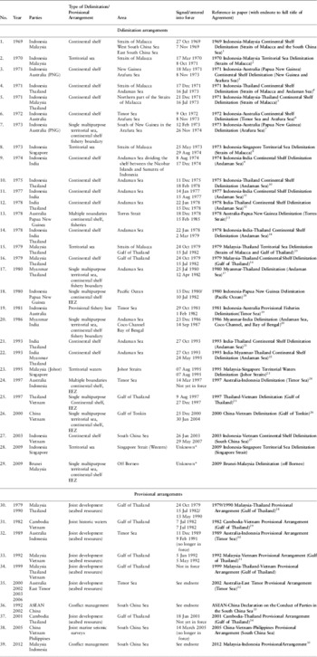
Southeast Asian states, consistent with states around the world,Footnote 40 have demonstrated a preference for negotiations as a dispute settlement mechanism. Since the end of the colonial period,Footnote 41 from 1969 to 2009, thirty-nine maritime boundary arrangements have been concluded in Southeast Asia. These maritime boundary arrangements can be categorized into two groups, either a (i) Delimitation Agreement whereby a boundary is agreed uponFootnote 42 or (ii) a Provisional Arrangement whereby no boundary is agreed upon, and where states have agreed to some form of joint exercise of jurisdiction and management of resources.Footnote 43 There are twenty-nine Delimitation Arrangements and ten Provisional Arrangements that have been concluded so far, although not all of them are presently in force. Indonesia has been especially productive, and is or has been party to seventeen out of the twenty-nine Delimitation Agreements. In contrast, the Philippines are party to none. As is clear from Table 1 (at the end of this paper), the majority of these Agreements are in the Andaman Sea, in the Straits of Malacca and Singapore, and in the Gulf of Thailand.
Maritime boundary arrangements in Southeast Asia

*This Agreement is not publicly available.
1 Agreement Between the Government of the Republic of Indonesia and the Government of Malaysia Relating to the Delimitation of the Continental Shelf Between the Two Countries, 27 October 1969, 9 ILM 1173 (1970) (entered into force 7 November 1969).
2 Treaty Between the Republic of Indonesia and Malaysia Relating to the Delimitation of the Territorial Seas of the Two Countries in the Straits of Malacca, 17 March 1970, Limits in the Seas No. 50 (1973) (entered into force 8 October 1971).
3 Agreement Between the Government of the Commonwealth of Australia and the Government of the Republic of Indonesia Establishing Certain Seabed Boundaries, 18 May 1971, 974 UNTS 307 (1975) (entered into force 8 November 1973).
4 Agreement Between the Government of the Republic of Indonesia and the Government of the Kingdom of Thailand Relating to the Delimitation of a Continental Shelf Boundary Between the Two Countries in the Northern Part of the Malacca Straits and the in the Andaman Sea, 17 December 1971, Limits in the Seas No. 81 (1978) (entered into force 16 July 1973).
5 Agreement Between the Government of the Republic of Indonesia, the Government of Malaysia and the Government of the Kingdom of Thailand Relating to the Delimitation of the Continental Shelf Boundaries in the Northern Part of the Malacca Straits, 21 December 1971, Limits in the Seas No. 81 (1978) (entered into force 16 July 1973).
6 Agreement Between the Government of the Commonwealth of Australia and the Government of the Republic of Indonesia Establishing Certain Seabed Boundaries in the Area of the Timor and Arafura Seas Supplementary to the Agreement of 18 May 1971, 9 October 1972, Limits in the Seas No. 87 (1979) (entered into force 8 November 1973).
7 Agreement Between Australia and Indonesia Concerning Certain Boundaries Between Papua New Guinea and Indonesia, 12 February 1973, 975 UNTS 4 (1975) (entered into force 26 November 1974).
8 Agreement Stipulating the Territorial Sea Boundary Lines Between Indonesia and the Republic of Singapore in the Strait of Singapore, 25 May 1973, Limits in the Seas No. 60 (1974) (entered into force 29 August 1974).
9 Agreement Between the Government of the Republic of India and the Government of the Republic of Indonesia, 8 August 1974, Limits in the Seas No. 62 (1975) (entered into force 17 December 1974).
10 Agreement Between the Government of the Republic of Indonesia and the Government of the Kingdom of Thailand Relating to the Delimitation of the Seabed Boundary Between the Two Countries in the Andaman Sea, 11 December 1975, Limits in the Seas No. 93 (1981) (entered into force 18 February 1978).
11 Agreement Between the Government of the Republic of India and the Government of the Republic of Indonesia on the Extension of the 1974 Continental Shelf Boundary Between the Two Countries in the Andaman Sea and the Indian Ocean, 14 January 1977, Limits in the Seas No. 93 (1981) (entered into force 15 August 1977).
12 Agreement Between the Government of the Republic of India and the Government of the Kingdom of Thailand on the Delimitation of Seabed Boundary Between the Two Countries in the Andaman Sea, 22 June 1978, Limits in the Seas No. 93 (1981) (entered into force 15 December 1978).
13 Treaty Between Australia and the Independent State of Papua New Guinea Concerning Sovereignty and Maritime Boundaries in the Area Between the Two Countries, Including the Area Known as Torres Strait, and Related Matters, 18 December 1978, 118 ILM 291 (1979) (entered into force 15 February 1985).
14 Agreement Between the Government of the Republic of India, the Government of the Republic of Indonesia and the Government of the Kingdom of Thailand Concerning the Determination of the Trijunction Point and the Delimitation of the Related Boundaries of the Three Countries in the Andaman Sea, 22 June 1978, Limits in the Seas No. 93 (1981) (entered into force 2 March 1979).
15 Treaty Between the Kingdom of Thailand and Malaysia Relating to the Delimitation of the Territorial Seas of the Two Countries, 24 October 1979, Maritime Boundary Agreements (1970–1984) 212 (1987) (entered into force 15 July 1982).
16 Memorandum of Understanding Between the Kingdom of Thailand and Malaysia on the Delimitation of the Continental Shelf Boundary Between the Two Countries in the Gulf of Thailand, 24 October 1979, 1 Canadian Annex 607 (1983) (entered into force 15 July 1982).
17 Agreement Between the Government of the Socialist Republic of the Union of Burma (Myanmar) and the Government of the Kingdom of Thailand on the Delimitation of the Maritime Boundary Between the Countries in the Andaman Sea, 25 July 1980, Limits in the Seas No. 102 (1985) (entered into force 12 April 1982).
18 Agreement Between the Government of the Republic of Indonesia and the Government of Papua New Guinea Concerning the Maritime Boundary Between the Republic of Indonesia and Papua New Guinea and Cooperation on Related Matters, 13 December 1980, Canadian Annex 661, 10 July 1982.
19 Memorandum of Understanding Between the Government of the Republic of Indonesia and the Government of Australia Concerning the Implementation of a Provisional Fisheries Surveillance and Enforcement Arrangement, 29 October 1981, reproduced in Jonathan CHARNEY and Lewis ALEXANDER, eds., International Maritime Boundaries, Vol. II (Leiden: Martinus Nijhoff Publishers, 1993) at 1229–43 (entered into force 1 February 1982).
20 Agreement Between Socialist Republic of the Union of Burma (Myanmar) and the Republic of India on the Delimitation of the Maritime Boundary in the Andaman Sea, in the Coco Channel and in the Bay of Bengal, 23 December 1986, 27 ILM 1144 (1988) (entered into force 14 September 1987).
21 Agreement Between the Government of the Republic of India and the Government of the Kingdom of Thailand on the Maritime Boundary Between the Two Countries in the Andaman Sea from Point 7 to the Tri-Junction Point (Point T) Between India, Thailand, Myanmar, 27 October 1993, reproduced in Jonathan CHARNEY and Lewis ALEXANDER, eds., International Maritime Boundaries, Vol. III (Leiden: Martinus Nijhoff Publishers, 1998) at 2380–2 (unknown entry into force).
22 Agreement Between the Government of the Union of Myanmar, the Government of the Republic of India and the Government of the Kingdom of Thailand on the Determination of the Trijunction Point Between the Three Countries in the Andaman Sea, 27 October 1993, 30 LOS Bulletin 66 (entered into force 24 May 1995).
23 Agreement Between the Government of Malaysia and the Government of the Republic of Singapore to Delimit Precisely the Territorial Waters Boundary in Accordance with the Straits Settlements and Johore Territorial Waters Agreement 1927, 7 August 1995, reproduced in Charney and Alexander, supra note 21 at 2351–3 (entered into force 7 August 1995).
24 Treaty Between the Government of Australia and the Government of Indonesia Establishing an Exclusive Economic Boundary and Certain Seabed Boundaries, 14 March 1997, 36 ILM 1053 (1997) (not yet entered into force).
25 Agreement Between the Government of the Kingdom of Thailand and the Government of the Socialist Republic of Vietnam on the Delimitation of the Maritime Boundary Between the Two Countries in the Gulf of Thailand, 9 August 1997, LOS Bulletin 23 (2000) (entered into force 27 December 1997).
26 Agreement on the Delimitation of the Territorial Seas, Exclusive Economic Zones and Continental Shelves in the Beibu Gulf (Gulf of Tonkin) Between the People's Republic of China and the Socialist Republic of Vietnam, 25 December 2000, reproduced in David COLSON and Robert SMITH, eds., International Maritime Boundaries, Vol. V (Leiden: Martinus Nijhoff Publishers, 2005) at 3755–8 (entered into force 30 June 2004).
27 Agreement Between the Government of the Socialist Republic of Vietnam and the Republic of Indonesia Concerning the Delimitation of the Continental Shelf Boundary, 26 June 2003, 67 LOS Bulletin, 39 (entered into force 29 May 2007).
28 The 1979/1990 Malaysia-Thailand Provisional Arrangement (Gulf of Thailand) consists of the following agreements:
a) Memorandum of Understanding Between the Kingdom of Thailand and Malaysia on the Delimitation of the Establishment of a Joint Authority for the Exploitation of the Resources of the Sea-bed in a Defined Area of the Continental Shelf of the Two Countries in the Gulf of Thailand, 24 October 1979, 1 Canadian Annex 607 (1983) (entered into force on 15 July 1982).
b) Agreement between the Government of Malaysia and the Government of the Kingdom of Thailand on the Constitution and Other Matters Relating to the Establishment of the Malaysia-Thailand Joint Authority, 13 May 1990.
29 Agreement on Historic Waters of Vietnam and Kampuchea, 7 July 1982, reproduced in Charney and Alexander, supra note 21 at 2364–5 (entered into force 7 July 1982).
30 Treaty Between Australia and the Republic of Indonesia on the Zone of Cooperation in an Area Between the Indonesian Province of East Timor and Northern Australia, 11 December 1989, 29 ILM 469 (1990) (entered into force 9 February 1991).
31 Memorandum of Understanding Between Malaysia and the Socialist Republic of Vietnam for the Exploration and Exploitation of Petroleum in a Defined Area of the Continental Shelf Involving the Two Countries, 5 June 1992, reproduced in Charney and Alexander, supra note 21 at 2341–4 (entered into force 5 June 1992).
32 The 2002 Australia-East Timor Provisional Arrangement (Timor Sea) is established under the following documents:
a) Memorandum of Understanding Between the Government of Australia and the United Nations Transitional Administration in East Timor (UNTAET) Acting on Behalf of East Timor on Arrangements Relating to the Timor Gap Treaty, 10 February 2000, Australia Treaty Series 2000, No. 9 (entered into force 10 February 2000, with effect from 25 October 1999).
b) Timor Sea Treaty Between the Government of East Timor and the Government of Australia, 20 May 2002 (2002) Australian Treaty Series 13 (entered into force 2 April 2003).
c) Agreement Between the Government of Australia and the Government of the Democratic Republic of East Timor Relating to the Unitization of the Sunrise and Troubadour Fields, 6 March 2003, 2183 UNTS 3 (No. I-44576) (entered into force 23 February 2007).
d) Treaty Between Australia and the Democratic Republic of Timor-Leste on Certain Maritime Arrangements in the Timor Sea, 12 January 2006, Australian Treaty Series [2007] ATS 12 (entered into force 23 February 2007).
33 1992 ASEAN Declaration on the South China Sea, adopted by the Foreign Ministers of ASEAN at the 25th ASEAN Ministerial Meeting in Manila, Philippines on 22 July 1992; 2002 ASEAN-China Declaration on the Conduct of Parties in the South China Sea, adopted by the Foreign Ministers of ASEAN and the People's Republic of China at the 8th ASEAN Summit in Phnom Penh, Cambodia on 4 November 2002.
34 Memorandum of Understanding Between the Royal Government of Cambodia and the Royal Thai Government Regarding the Area of Their Overlapping Maritime Claims to the Continental Shelf, 18 June 2001, reproduced in Colson and Smith, supra note 26 at 3743–4.
35 Memorandum of Understanding Between the Government of the Republic of Indonesia and the Government of Malaysia in Respect of the Common Guidelines Concerning Treatment of Fishermen by Maritime Law Enforcement Agencies of the Republic of Indonesia and Malaysia, 27 January 2012.
In comparison, Southeast Asian states have only rarely used third-party binding dispute settlement to resolve maritime boundary disputes.Footnote 44 There has only been one instance of a dispute involving a Southeast Asian state being heard by an international court, namely the recent case concerning delimitation of the maritime boundary between Bangladesh and Myanmar in the Bay of Bengal,Footnote 45 and this dispute was unilaterally referred to dispute settlement by Bangladesh. The next three Parts of this paper will examine the approaches of Southeast Asian states to maritime delimitation agreements, provisional arrangements, and third-party dispute settlement in greater detail.
III. SOUTHEAST ASIAN APPROACHES TO THE NEGOTIATIONS OF MARITIME DELIMITATION AGREEMENTS
Amongst the dispute settlement mechanisms recognized by international law for maritime boundary disputes, maritime delimitation agreements have a high priority under UNCLOS. Article 15 of UNCLOS requires states to determine their territorial sea boundary by agreement, and in the absence of agreement the median line should be employed as the boundary unless historic title or other special circumstances warrant otherwise. With regard to overlapping EEZ/continental shelf claims, Articles 74(1) and 83(1) require delimitation of the EEZ/continental shelf to be effected by agreement on the basis of international law in order to achieve an equitable solution.
Unsurprisingly, maritime delimitation agreements are the most frequent form of dispute settlement employed by states. Southeast Asian states are no exception and, as mentioned above, Southeast Asian states had concluded twenty-nine Delimitation Agreements between 1969 and 2009. Compared to some other regions in the Asia-Pacific, Southeast Asia has been particularly prolific in its conclusion of Delimitation Agreements. For example, in Northeast Asia (Sea of Japan, Yellow Sea, and the East China Sea),Footnote 46 there are currently only four maritime delimitation agreements in force,Footnote 47 with sovereignty disputes over islands continuing to be a challenge to maritime boundary-making.
Despite the requirement in Articles 74(1) and 83(1) that maritime delimitation agreements be concluded on the basis of international law, states are not bound to take into consideration the rules and principles governing maritime delimitation under international law. They “are free to agree to any boundary they want provided that the rights and interests of third states or of the international community are not prejudiced”.Footnote 48 Notwithstanding this, international law will inevitably play a role in negotiations. As noted by Antunes, “[c]laims advanced by States are virtually always marked by the expression of an understanding of international law. While not necessarily determined by normative standards, agreements often incorporate a compromise between opposing views on normativity.”Footnote 49
In this regard, Southeast Asian states have demonstrated a remarkably innovative, flexible, and conciliatory approach towards the use of international law in their Delimitation Agreements. The following sections will demonstrate this by examining (A) Types of Maritime Delimitation Agreements, (B) Baselines in Maritime Delimitation Agreements, (C) Legal Principles Adopted in Maritime Delimitation Agreements, (D) Co-operative Arrangements in Delimitation Agreements, and (E) Factors Driving Maritime Delimitation Agreements in Southeast Asia.
A. Types of Maritime Delimitation Agreements
To date, Southeast Asian states have shown a distinct preference for simple linear settlements, i.e. the drawing of a line, which represents a single-purpose maritime boundary, either of the territorial sea, or the EEZ, or the continental shelf. Of the twenty-nine Delimitation Arrangements listed in Table 1, five are territorial sea delimitations and fourteen are continental shelf boundaries. Arguably, there is one example of a single-purpose EEZ boundary in Southeast Asia, the 1997 Australia-Indonesia EEZ Boundary (which converted the boundary provisionally established in the 1981 Provisional Fisheries Surveillance and Enforcement Arrangement into an EEZ boundary), but this also continued the seabed boundary established in 1972 between Australia and Indonesia. Accordingly, the 1997 Australia-Indonesia EEZ Boundary is more accurately described as a multiple line delimitation (separate boundaries for the EEZ and continental shelf), which will be dealt with below.
States in Southeast Asia have also adopted single multipurpose boundaries, i.e. one boundary which delimits both the EEZ and continental shelf (hereinafter referred to as the “single maritime boundary”), although they are in the minority compared with the single-purpose boundaries above. Of the twenty-nine Delimitation Agreements, five are single maritime boundaries (see Table 1). This is consistent with international state practice as well as judicial preference for a single maritime boundary delimiting both the EEZ and the continental shelf.Footnote 50 Judicial and state support for a single maritime boundary appears to be motivated by considerations of simplicity, certainty, and convenience.Footnote 51 As noted by Judge Oda in Tunisia/Libya:
It is congruous or conceivable that the same marine/submarine column should be placed under different national jurisdictions for the same purpose of resource exploitation, however different the resources may be and that the same area of ocean be consequently policed by two different States. One is entitled to enquire whether superimposition of two different boundaries is tolerable as a matter of international ordre public.Footnote 52
Despite the perceived advantages of single maritime boundaries, there is no legal impediment to having two separate boundaries. UNCLOS “does not indicate that the boundaries delimiting the continental shelf and the EEZ ought to be combined in a single line”.Footnote 53 Indeed, Southeast Asia is unique in that it is the only region in the world which has adopted two separate boundaries for the EEZ and continental shelf for the same area, departing from judicial preference and state practice. The first example is the 1978 Australia-Papua New Guinea Delimitation (Torres Strait) which establishes two separate boundariesFootnote 54 between Australia and Papua New Guinea in the Torres Strait, namely a “seabed jurisdiction line”, which delimits the sovereign rights of each state over the continental shelf,Footnote 55 and a fisheries jurisdiction line, which delimits the sovereign rights of each state “for the purpose of exploring and exploiting, conserving and managing fisheries resources other than sedentary species”.Footnote 56
The second example of two separate boundaries is in the Timor Sea, where separate boundaries were established between Australia and Indonesia through three consecutive agreements. First, in 1972, Australia and Indonesia established their seabed boundaries in the Timor Sea and Arafura Sea (Arrangement No. 6 in Table 1). Indonesia had argued that equidistance should be the applicable delimitation principle, whereas Australia (arguably bolstered by the 1969 North Sea Continental Shelf cases, which had given support to the idea that the continental shelf was the “natural prolongation” of one's territory) argued that the Timor Trough was the “natural boundary” between Indonesia and Australia. Neither country was able to secure its maximum claim, and a line was drawn between the line of equidistance to the south and the axis of the Timor Trough to the north. The boundary favoured Australia as it gave Australia a greater portion of the seabed. The second agreement in this area came in 1981 in the form of the Provisional Fisheries Surveillance and Enforcement Arrangement, where Australia and Indonesia agreed on a provisional fisheries line which diverged from the seabed boundary and was closer to the equidistance line favoured by Indonesia (see Arrangement No. 19 in Table 1).Footnote 57 The third agreement in 1997 (see Arrangement No. 24 in Table 1)Footnote 58 converted the provisional fisheries line to an EEZ boundary (based on equidistance) and also extended the 1972 seabed boundary westwards.
B. Baselines in Maritime Delimitation Agreements
A state's maritime zones are drawn from its baselines. Under UNCLOS, a state can draw a normal baseline which follows the low-water line along the coast.Footnote 59 However, in localities where the coastline is deeply indented and cut into, or if there is a fringe of islands along the coast in the immediate vicinity of the coast, a state can use straight baselines.Footnote 60 States which meet the definition of “archipelagic States” under Article 46 can also draw straight archipelagic baselines.Footnote 61
Most maritime delimitations take as their starting point the baseline of the territorial sea. Baselines or, more specifically, base points along baselines, are critical in constructing a provisional delimitation line based on equidistance.Footnote 62 However, with regard to general state practice, maritime boundary agreements often do not mention the type or co-ordinate of baselines used.Footnote 63 Likewise, it is also often not clear when straight baselines have been used in the construction of a maritime boundary and there are only a few cases in which it is “clear that there is a link between these two sets of lines”.Footnote 64 However, in a survey of the world's maritime boundaries carried out in 1993, it was reported that there were some twenty cases in which straight baselines were specifically taken into account, and in some fifty cases they were disregarded either in whole or in part.Footnote 65 However, it is not clear how many of these were cases of straight baselines that were adopted contrary to UNCLOS.
In international case-law, the International Court of Justice (ICJ) has found that the issue of determining the baseline for the purpose of measuring the breadth of the continental shelf and the EEZ, and the issue of identifying base points for the drawing of an equidistance line for the purpose of delimiting the continental shelf and the EEZ, are two different issues.Footnote 66 The Court is not bound by the base points in baselines determined by the parties.Footnote 67 Further, the ICJ has also held that “the method of straight baselines, which is an exception to the normal rules for the determination of baselines … must be applied restrictively”.Footnote 68
In contrast to the position taken by the ICJ, a significant number of Southeast Asian states have adopted straight baselines even when they do not meet the required conditions in Article 7 of UNCLOS.Footnote 69 Examples of Southeast Asian states which have drawn straight baselines contrary to the requirements in UNCLOS are Cambodia,Footnote 70 Malaysia,Footnote 71 Myanmar,Footnote 72 the Philippines,Footnote 73 Thailand,Footnote 74 and Vietnam.Footnote 75
When concluding Delimitation Agreements, some Southeast Asian states have demonstrated a flexible approach to the use of baselines. There are examples of one party accepting the use of straight baselines by another party even though those straight baselines were not in strict compliance with UNCLOS. A prime example of this is the 1969 Indonesia-Malaysia Continental Shelf Delimitation (Straits of Malacca and the South China Sea). The 1969 Agreement divided the continental shelves of Malaysia and Indonesia into three areas: the Straits of Malacca, the western side of the South China Sea, and the eastern side of the South China Sea. In the Straits of Malacca, a median line was used to divide the continental shelf equally. However, this ostensibly equal division was based on straight baselines being adopted by both Indonesia and Malaysia. Indonesia, of course, argued for the regime of archipelagic waters, which employed straight baselines.Footnote 76 Malaysia had not specified its baselines by geographic co-ordinates at the time of signing.Footnote 77 However, Malaysia's straight baselines “were apparently intended to put Malaysia on an equal footing in the division of the continental shelf with Indonesia which had previously drawn straight baselines”.Footnote 78 Under international law applicable at the time, Malaysia would not qualify as a state entitled to draw straight baselines, which, as mentioned above, is only reserved for states which meet certain geographic conditions.Footnote 79 If a strict equidistant line using Malaysia's normal baselines had been used, Indonesia would have gained about 1,000 square nautical miles (sq nm) of continental shelf.Footnote 80 Indonesia's acceptance of Malaysia's use of straight baselines was seen as a “gift” from Indonesia to Malaysia for the latter's support of the regime of archipelagic waters during negotiations of the Third UN Convention on the Law of the Sea.Footnote 81 Indonesia also accepted the questionable use of Malaysia's straight baselines in the 1970 Indonesia-Malaysia Territorial Sea Delimitation (Straits of Malacca). However, it should be noted that the acceptance of Malaysia's straight baselines in these agreements has caused issues in the negotiations of an EEZ boundary with Malaysia in the Straits of Malacca.Footnote 82
There have also been cases where two parties have declared straight baselines in contravention of UNCLOS but have disregarded them for purposes of maritime boundary delimitation, retracting from their extreme claims. For example, while both China and Vietnam proclaimed straight baselines around certain areas of their coast, including straight baselines around China's Hainan Island, they did not do so in the 2000 China-Vietnam Delimitation (Gulf of Tonkin)Footnote 83 (although it has been suggested that a small segment of the agreed boundary appears to have been influenced by straight baselines drawn by China for Hainan Island).Footnote 84 Similarly, in the 1997 Thailand-Vietnam Delimitation (Gulf of Thailand), both countries also disregarded their straight baselines for purposes of delimitation of the territorial sea, EEZ, and continental shelf boundary.Footnote 85
C. Legal Principles Adopted in Maritime Delimitation Agreements
As mentioned above, both Articles 15 and Articles 74/83 set out the principles relevant for the delimitation of the territorial sea and EEZ/continental shelf respectively. Article 15 endorses equidistance for delimitation of the territorial sea unless special circumstances warrant an adjustment (known as the “equidistance-special circumstances” rule). Articles 74 and 83 merely state that delimitation of the EEZ/continental shelf “should be effected by agreement on the basis of international law, as referred to in Article 38 of the Statute of the International Court of Justice, in order to achieve an equitable solution”. The vagueness of this formulation is attributable to the difficulties in obtaining agreement of the states negotiating UNCLOS on the applicable principles for delimitation.Footnote 86 Some states preferred the equidistance principle, taking into account “special circumstances” when necessary, as the main principle of delimitation, whereas others wanted to emphasize equitable principles.Footnote 87 Articles 74 and 83 contained language which gave precedence to neither argument. However, over the years, the decisions of international courts and tribunals have attempted to articulate what is meant by “equitable solution” and such jurisprudence is recognized to be relevant to the interpretation of Articles 74 and 83.Footnote 88
There are two distinct phases in international jurisprudence. The first phase from 1969 to 1992Footnote 89 has been characterized as the “equitable principles-relevant circumstances” phase.Footnote 90 Delimitation was to
be effected in accordance with equitable principles or equitable criteria, taking account of all the relevant circumstances, in order to achieve an equitable result. The underlying premise of this fundamental norm is the emphasis on equity and the rejection of any obligatory method.Footnote 91
Under this approach, equitable principles gave no primacy to equidistance as a method of delimitation.Footnote 92 Instead, the goal of achievement of equitable results was the most important in delimitation (as opposed to the method of delimitation).Footnote 93
However, this approach was modified in the later cases from 1993 onwards which found that the “equitable principles-relevant circumstances” rule as it had been adopted since 1958 is “closely interrelated”Footnote 94 or “very similar”Footnote 95 to the “equidistance/special circumstances” method applicable to the delimitation of the territorial sea.Footnote 96 This has been described as the “corrective-equity” approachFootnote 97 or the “equidistance/relevant circumstances” approach.Footnote 98 While the need for an equitable solution is still the defining goal, the courts have now set out a definite methodology in order to achieve such an equitable solution. Initially, this methodology consisted of two steps whereby the courts first drew a provisional equidistance line and will then consider whether there are factors calling for the adjustment of that line in order to achieve an equitable result.Footnote 99 Most recently, this has been modified to three steps in the 2009 Black Sea case:Footnote 100
-
1. First, the Court will establish a provisional equidistance or median line unless there are compelling reasons that make this unfeasible in a particular case.
-
2. At the second stage, the Court will consider whether there are factors calling for the adjustment or shifting of the provisional equidistance line in order to achieve an equitable result. During this stage the Court will consider factors such as the configuration of the coasts concerned and the presence of islands.
-
3. Finally, at the third stage, the Court will verify that the line does not, as it stands, lead to an inequitable result by reason of any marked disproportion between the ratio of the respective coastal lengths and the ratio between the relevant maritime area of each state by reference to the delimitation line. This final check for an equitable outcome entails a confirmation that no great disproportionality of the delimited maritime areas can be evident by comparison to the ratio of coastal lengths.
In this regard, Southeast Asian states have certainly employed international law principles in their negotiations, utilizing the more recognized “equidistance/relevant circumstances” methodology. Fifteen of the Delimitation Agreements in Southeast Asia appear to have adopted equidistance as the applicable method for delimitation.Footnote 101 That said, the relatively high use of equidistance cannot be said to reflect a particular circumstance of the region and merely reflects that equidistance is generally applied as a point of departure in maritime boundary negotiations worldwide.Footnote 102 Indeed, as mentioned above, the equidistant line has been recognized as having a primary place in delimitation methodology by the ICJ, as reflected by the use of a provisional equidistance line in the first stage of delimitation.
Despite the prevalence of equidistance as a method of delimitation, there are nearly an equal number of Delimitation Agreements in which Southeast Asian states have negotiated variations of equidistance, adjusting the equidistance line to take into account special circumstances. This has not always resulted in an equal division of maritime space.Footnote 103 Southeast Asian states have demonstrated a willingness to adopt a flexible approach towards “relevant circumstances”, and on many occasions have not pushed their maximum legal claims in order to get agreement on their maritime boundaries. This will be illustrated with several examples below.
1. Geological and geomorphologic circumstances
Under international law, geological and geomorphologic factors (i.e. the composition and shape of the seabed) can constitute relevant circumstances which would require an adjustment of the equidistance line.Footnote 104 Geological and geomorphologic circumstances have played a role in adjusting the equidistance line in Delimitation Agreements in Southeast Asia, although they were concluded before the 1985 Libya/Malta Continental Shelf caseFootnote 105 which marked the beginning of the decline of geological and geomorphologic circumstances in maritime delimitation.Footnote 106
Indonesia, in particular, has agreed to an adjustment in the equidistance line to take into consideration characteristics of the seabed, hence affording the other party a greater share of the seabed. For example, the 1972 Indonesia-Australia Continental Shelf Delimitation (Timor Sea and Arafura Sea) referred to above was not an equidistant one despite Indonesia's preference for one. The boundary was drawn between the line of equidistance to the south and the axis of the Timor Trough to the north, favouring Australia and its arguments that the Timor Trough was a geomorphologic circumstance which interrupted the unity of the seabed. Similarly, the continental shelf boundary established in the 1997 Indonesia-Australia Delimitation (Timor Sea) again favoured Australia's arguments on geomorphologic circumstances, although it established an equidistance line for the EEZ.
The 1973 Indonesia-Singapore Territorial Sea Delimitation (Straits of Malacca) uses both the equidistance principle (three points) and a negotiated variation of the equidistance principle (three points). Two of the three negotiated points on the west are slightly closer to Indonesia and hence favour Singapore. Interestingly, one of the points lies within Indonesia's internal/archipelagic waters,Footnote 107 which means that a “small patch of Singapore's territorial seas” cuts into Indonesia's internal waters.Footnote 108 This was a pragmatic consideration so as to accommodate the deep-draft tanker route that lies close to the boundary. Indonesia took into account the geomorphologic considerations of the seabed for pragmatic reasons, in a way which favoured Singapore.Footnote 109
Another example is the boundary in the 1975 Indonesia-Thailand Continental Shelf Delimitation (Andaman Sea), which lay on the Indonesian side of a strict line of equidistance and favoured Thailand.Footnote 110 Charney and Alexander suggest that one possible reason for the concession by Indonesia could be the geomorphologic conditions of the seabed. The continental shelf adjacent to Thailand is wider than that adjoining Indonesia, and there is a broad depression between them, i.e. the seabed shelves much more steeply off the Indonesian coast than off the Thai coast.Footnote 111 Further, a spur of shallower seabed extends from the Thai margin north of Dreadnought Bank.Footnote 112 It appears that Indonesia recognized the equity of giving Thailand areas of the adjacent margin beyond the strict line of equidistance.Footnote 113
Similarly, in the 1978 India-Indonesia-Thailand Continental Shelf Delimitation (Andaman Sea), the parties agreed to a tri-junction point which resulted in India securing full equidistance entitlement, with Thailand securing more than its full equidistance entitlement and Indonesia obtaining less than its full equidistance entitlement.Footnote 114 The concession made to Thailand compared with the equidistance line was borne entirely by Indonesia and has to do with the same considerations that resulted in the 1975 Indonesia-Thailand Continental Shelf Boundary discussed above being not equidistant.Footnote 115
2. Offshore features
Under Article 121 of UNCLOS, a feature which qualifies as an “island”, i.e. a naturally formed feature above water at high tide, and which is capable of sustaining human habitation or an economic life of its own, is entitled to a territorial sea, EEZ, and continental shelf of its own.Footnote 116 If it is not capable of sustaining human habitation or an economic life of its own, it is considered a “rock”, only entitled to a territorial sea.Footnote 117 The meaning of “sustaining human habitation and economic life of its own” was left deliberately vague in UNCLOS and has been subject to several different interpretations.Footnote 118
The issue of whether a particular feature qualifies as an “island” capable of generating extended maritime zones and its resultant effect on delimitation has also been a frequent bugbear in maritime delimitation negotiations and adjudications.Footnote 119 Generally, under international case-law, if there are overlapping claims between a maritime zone measured from a small remote island and a maritime zone from the mainland or from an archipelagic state, the practice of courts and tribunals is to give a significantly reduced effect to the island when delimiting the maritime boundary.Footnote 120 In negotiations, it will be up to the parties to decide what effect is given to islands in delimitation.
Southeast Asian states have shown a conciliatory approach in their treatment of offshore features in Delimitation Agreements. Many states have allowed their own offshore features which could reasonably qualify as “islands” to have a reduced effect in delimitation, or have agreed that offshore features belonging to other states can have full effect.
The first example of this is the 1969 Indonesia-Malaysia Continental Shelf Delimitation (Straits of Malacca and the South China Sea). The boundary drawn on the eastern side of the South China Sea off the coast of SarawakFootnote 121 originates from Tanjong Datu, the northern terminus of the land boundary between Indonesia's Kalimantan and Malaysia's Sarawak. It is not based on equidistance and is slightly on the Indonesian side of what would be the median line from the base points of the parties. The Indonesian Islands situated northwest of Tanjong Datu were not given full effect on Malaysia's insistence.Footnote 122
In the 1971 Indonesia-Thailand Continental Shelf Delimitation (Straits of Malacca and Andaman Sea), an equidistance line was used. However, Indonesia did not object to Thailand using small islands 30 nm from the mainland as base points, i.e. they were given full effect.Footnote 123
Similarly, in the 1980 Indonesia-Papua New Guinea Delimitation (Pacific Ocean), Indonesia concluded a continental shelf boundary with Papua New Guinea based on an equidistant line between Indonesia's cape north of Djajapura and from Papua New Guinea's Wuvulu Island. Indonesia clearly allowed Wuvulu Island to be given full effect, even though Wuvulu lies more than 230 km from Papua New Guinea. If Wuvulu had not been given full effect, one of the points of the maritime boundary would have been located further east in favour of Indonesia.Footnote 124
The 1986 Myanmar-India Delimitation (Andaman Sea, Coco Channel, and in the Bay of Bengal) is also an interesting example of flexible and conciliatory treatment of offshore features between a Southeast Asian state and a South Asian state. This boundary is approximately 600 nm in length and separates India's maritime claims measured from the Andaman and Nicobar Islands from Myanmar's maritime claims. The countries used both an equidistant boundary as well as a negotiated variance of the equidistant boundary.Footnote 125 This was a particularly difficult boundary to draw, and negotiations took eleven years.Footnote 126 One of the major obstacles to the conclusion of the boundary was, first, the fact that Myanmar and India claimed sovereignty over the Narcondam Islands, east of the Andaman Islands. Second, Myanmar disputed India's right to claim extended maritime zones from the Narcondam Islands. Using the Narcondam Islands as a base point for an equidistance line would have given India a marked advantage. On India's part, India objected to the correctness of Myanmar's baseline across the Gulf of Martaban and was opposed to that baseline being used in generating equidistance points on the boundary.Footnote 127 However, both states compromised in order to reach an agreement on delimitation. Myanmar gave up its claim to the the Narcondam Islands and also did not insist on the closing line across the Gulf of Martaban being used to fix the boundary.Footnote 128 In exchange, part of the boundary either completely discounts India's claim from both the Barren and Narcondam Islands or gives them half-effect.Footnote 129 The net result is that Myanmar gained about 6,225 sq nm above its entitlement according to a strict application of the equidistance principles.Footnote 130
Another notable example is the 1997 Thailand-Vietnam Delimitation (Gulf of Thailand), which was Vietnam's first delimitation agreement. When Thailand made its continental shelf claim vis-à-vis Vietnam in 1973, it had given no effect either to the Thai offshore feature Ko LosinFootnote 131 or to Vietnamese features in the Tho Chu archipelago. Similarly, Vietnam's claim to the continental shelf in 1971 gave full effect to the features in the Tho Chu archipelago but no effect to Ko Losin.Footnote 132 However, both parties retracted from their absolute positions and agreed to give due weight to both Ko Losin and the Tho Chu archipelago.Footnote 133 This resulted in Thailand getting two-thirds of the disputed area and Vietnam getting one-third of the disputed area, although Charney and Smith note that “this inequity is more apparent than real” as the “maximum claims of both States exaggerate the area that was truly in dispute and subject to negotiation”.Footnote 134
The 2000 China-Vietnam Delimitation (Gulf of Tonkin), China's first maritime boundary agreement, has also been described as a “product of obvious compromise, creativity and the result of pragmatic considerations”.Footnote 135 Both parties considerably retracted from their initial hardline positions. During negotiations in the 1990s, Vietnam abandoned its claim of historic waters in the Gulf of Tonkin, and China also abandoned its proposal of a neutral zone in the shape of a rectangle in the middle of the gulf, within which no exploration or exploitation should take place. Vietnam also agreed not to give one of its islands, Bach Long Vi, which is 2.5 sq km, 62 m above sea level, and approximately 50 nm from Vietnam, full effect in constructing the boundary. It is estimated that the difference between an equidistance line using Bach Long Vi as a base point and one ignoring the island completely is approximately 1,700 sq km. Bach Long Vi was given a twenty-five percent effect on the delimitation line. The Vietnamese islet of Con Co was given half-effect in the southern areas of the Gulf of Tonkin. Other Vietnamese Islands, such as Chin Lan Xan and Cu Xu, were given some but not full effect in the inner reaches of the Gulf.Footnote 136 Further, both Vietnam and China agreed upon a common fishing zone, which made it easier for China to agree to a boundary line in the middle of the Gulf.Footnote 137
Last, the 2003 Indonesia-Vietnam Continental Shelf Delimitation (South China Sea) resolved a long-standing maritime boundary dispute between Indonesia and Vietnam around the Natuna Islands and “represents a compromise between the positions of the parties”.Footnote 138 The boundary consists of equidistant and non-equidistant sections. The western part of the boundary is equidistant between the Indonesian islands of Natuna and Vietnam's island of Hon Khoai.Footnote 139 It is clear that Indonesia got full effect for its islands in this part of the boundary and retained its control over hydrocarbon resources in the seabed around the Natunas.Footnote 140 However, as the boundary progresses, it veers south of the equidistance line in favour of Vietnam, which implies that Indonesia's islands were given only partial weight in the construction of this section of the line.Footnote 141 Colson and Smith suggest several reasons for this: the disparity in the relevant coastal fronts (Indonesia's concave coastline and small islands as against Vietnam's mainland coast and associated islands) and the fact that Indonesia's relevant island groups (the Natunas and Anambas) are considerably further offshore than Vietnam's islands.Footnote 142
D. Co-operative Arrangements in Delimitation Agreements
Another notable trend in Delimitation Agreements in Southeast Asia is the increasing use of co-operative arrangements in addition to the establishment of a boundary, ranging from loose agreements to co-operate in certain areas to concrete legal arrangements on co-operation with respect to resources.
Approximately half of the Delimitation Agreements contain a provision dealing with “unity of deposits”, i.e. where hydrocarbon resources straddle a boundary. These provisions most frequently simply establish the principle that if there is a common deposit lying across the boundary, there is a duty to negotiate and reach an agreement on the development of straddling resources.Footnote 143 However, Delimitation Agreements such as the 1979 Malaysia-Thailand Continental Shelf Delimitation (Gulf of Thailand) establish more specific rules in cases where there is a “unity of deposits”:
If any single geological petroleum or natural gas structure or field, or any mineral deposit of whatever character, extends across the boundary lines referred to in Article I, the two governments shall communicate to each other all information in this regard and shall seek to reach agreement as to the manner in which the structure, field or deposit will be most effectively exploited; and all expenses incurred and benefits derived therefrom shall be equitably shared.Footnote 144
There are also examples of more detailed co-operative arrangements on resources which were essential to the conclusion of the boundary. For example, and as mentioned above, the 2000 China-Vietnam Delimitation Agreement (Gulf of Tonkin) was concluded together with the 2000 Agreement on Fishery Co-operation in the Gulf of Tonkin, which established a common fishery zone, a buffer zone for small fishing boats, and a zone for transitional arrangements.Footnote 145
A more interesting example can be seen in the 2009 Brunei-Malaysia Delimitation, which has yet to be published. From available reports, it appears that on 16 March 2009, Malaysia and Brunei agreed to an Exchange of Letters which established the final delimitation of the territorial sea, continental shelf, and EEZ of both states off Borneo.Footnote 146 This area had been subject to a long-standing overlapping claim dispute between Brunei and Malaysia, particularly over Blocks L and M, which had been the subject of competing concessions by Malaysia and Brunei. However, along with the Delimitation Agreement, it was also announced that Blocks L and M would be situated on Brunei's continental shelf, but that Malaysia was given “unsuspendable” rights of access for the exploration and exploitation of Blocks L and M in exchange for giving up its claims over these Blocks.Footnote 147
There are rarely any provisions on co-operation on the maritime environment, although notably, for the first time in Southeast Asia, the 2003 Indonesia-Vietnam Continental Shelf Delimitation (South China Sea) required the two states to consult with each other in order to co-ordinate their policies on the protection of the marine environment.Footnote 148
E. Factors Driving Delimitation Agreements in Southeast Asia
1. Economic factors
Generally speaking, the need for maritime boundaries has been resource-induced,Footnote 149 and Southeast Asia is no different, with economic factors providing a major impetus for Delimitation Agreements.Footnote 150 For example, the need for hydrocarbon resources, coupled with a belief in the existence of hydrocarbon resources, played a considerable role in pushing parties to the Delimitation Agreements in the Gulf of ThailandFootnote 151 and the Andaman Sea,Footnote 152 the 2000 China-Vietnam Delimitation in the Gulf of TonkinFootnote 153 , and the 2003 Indonesia-Vietnam Continental Shelf Delimitation in the South China Sea around the Natuna IslandsFootnote 154 , as well as the 2009 Brunei-Malaysia Delimitation off Borneo.Footnote 155 While the need to exploit fishery resources appears to have played a less significant role in Delimitation Agreements in Southeast Asia (as evidenced by the smaller number of agreements delimiting the EEZ), such resources significantly influenced Australia and Indonesia in concluding their 1981 and 1997 Delimitation Agreements,Footnote 156 and also pushed China and Vietnam to agree to a boundary in the Gulf of Tonkin.Footnote 157
Another notable factor inducing Indonesia, Malaysia, Singapore, and Thailand to agree to Delimitation AgreementsFootnote 158 in the Straits of Malacca and Singapore is the need to ensure the safety of navigation and the protection of the marine environment in this intensely used narrow sea lane.Footnote 159
2. Political factors
One of the major reasons why Southeast Asia has been such an active arena for maritime boundary-making is the existence of good relations between Southeast Asian states,Footnote 160 particularly as ASEAN has matured as an organization. It has been noted that ASEAN Member States in particular “are both familiar and comfortable with one another and are careful to avoid unnecessary conflicts and provocations”.Footnote 161 For example, the ever-improving relations between Thailand and Vietnam, bolstered by Vietnam's entrance into ASEAN in 1995, facilitated the conclusion of the 1997 Thailand-Vietnam Delimitation Agreement in the Gulf of Thailand.Footnote 162 Further, the existence of good relations between Southeast Asian states and extra-regional states such as China and Vietnam was also instrumental in the 2000 China-Vietnam Delimitation in the Gulf of Tonkin.Footnote 163
3. Strategic reasons
There are also other strategic reasons why states such as Indonesia agreed to a relatively high number of boundaries compared with other Southeast Asian states. As noted by Charney and Alexander, Indonesia has been “diligent in negotiating maritime limits with its neighbours. It was much more active than its neighbours and it is generally true that Indonesia did not push hard for maximum claims but demonstrated a spirit of conciliation and willingness to compromise.”Footnote 164 This conciliatory compromise was in part a calculated compromise in order to secure support for Indonesian claims to archipelagic waters around the Indonesian archipelago. In 1957, Indonesia had declared straight baselines by “connecting the outermost points of the low-water mark of the outmost islands or part of such islands comprising Indonesian territory”.Footnote 165 This increased its ocean space by approximately 875,000 sq km. Accordingly, one of the reasons why Indonesia so readily agreed to maritime delimitation agreements that did not always give it the biggest advantage was to gain recognition of this method of drawing straight baselines.Footnote 166
IV. PROVISIONAL ARRANGEMENTS
As mentioned above, UNCLOS recognizes that the delimitation of a boundary may not always be possible. It requires states, pending agreement on maritime delimitation, and in a spirit of understanding and conciliation, “to make every effort to enter into provisional arrangements of a practical nature and during the transitional period, not to jeopardize or hamper the reaching of final agreement. Such arrangements shall be without prejudice to the final delimitation.”Footnote 167 This provision is designed to “promote interim regimes and practical measures that could pave the way for provisional utilization of disputed areas pending delimitation” and “constitutes an implicit acknowledgement of the importance of avoiding the suspension of economic development in a disputed maritime area”.Footnote 168 As noted by Prescott and Schofield, such co-operative arrangements are “evidence of the emergence of a more broad-based, functionalist and comprehensive approach to ocean management as opposed to more traditional legalistic and thus confrontational approaches focusing on the delimitation of a particular dividing line”.Footnote 169
UNCLOS leaves it to the discretion of the state as to the type of “provisional arrangements of a practical nature” they may enter into. They include a wide variety of arrangements such as mutually agreed moratoriums on all activities in overlapping areas, joint development or co-operation on fisheries, agreements on environmental co-operation, and agreements on the allocation of criminal and civil jurisdiction.
States have increasingly utilized provisional arrangements of a practical nature when there is an impasse in maritime delimitation negotiations and agreement on a boundary cannot be reached. A survey of state practice indicates that there are approximately thirty-two provisional arrangements adopted by states worldwide.Footnote 170 As reflected in Table 1, Southeast Asian states have concluded ten provisional arrangements in lieu of maritime delimitation. This is a relatively high number—the only other region with a higher number appears to be the Atlantic Ocean and Caribbean region.Footnote 171
The following paragraphs examine the two most common types of provisional arrangements adopted in Southeast Asia, namely joint development arrangements and conflict management arrangements.
A. Joint Development of Hydrocarbon Resources
Generally, joint development arrangements are one of the most common types of “provisional arrangements of a practical nature” under Articles 74(3) and 83(3) of UNCLOS. Joint development is usually used as a “generic term”Footnote 172 and extends from unitization of a single resource straddling an international boundary to joint development of a shared resource where boundary delimitation is shelved because it is not feasible or possible to reach an agreed boundary at the timeFootnote 173 (this present paper is concerned with the latter type of joint development arrangement). International courts and tribunals have endorsed joint development agreements as an alternative to maritime delimitation.Footnote 174 For example, in the North Sea Continental Shelf cases, the ICJ held that joint exploration agreements were “particularly appropriate when it is a question of preserving the unity of a deposit” in areas of overlapping claims.Footnote 175 In his Dissenting Opinion in the 1982 continental shelf delimitation case between Tunisia and Libya, Judge ad hoc Evensen proposed a system of joint exploration of petroleum resources based on his view that joint development represented an alternative equitable solution to the maritime boundary dispute, which was eventually adopted by the parties.Footnote 176 In the Eritrea/Yemen arbitration, the Arbitral Tribunal stated that the parties should give every consideration to the shared or joint or unitized exploitation of any such resources.Footnote 177
In line with state practice and the endorsement of international courts and tribunals, states in Southeast Asia have frequently employed the joint development of hydrocarbon resources as a “provisional arrangement of a practical nature”, pending delimitation of overlapping maritime claims. Out of the ten provisional arrangements referred to in Table 1, eight concern co-operation on hydrocarbon resources.
1. Factors driving joint development arrangements in Southeast Asia
There are several reasons why Southeast Asian states have chosen joint development in lieu of a maritime delimitation agreement. First, agreement on such arrangements is usually preceded by an insurmountable impasse on national positions in negotiations of a maritime boundary. For example, with regard to the 1979/1990 Malaysia-Thailand Provisional Arrangement, the states were able to agree on a continental shelf boundary up to 29 nm in the Gulf of Thailand in 1972.Footnote 178 However, negotiations stalled because of a disagreement over the use of Ko Losin, a feature located approximately 39 nm offshore and 1.5 m above water at high tide with a light beacon on it.Footnote 179 Thailand insisted that Ko Losin was to be treated as a base point in measuring the continental shelf boundary at the expense of Malaysia, whereas Malaysia insisted that Ko Losin should not be used as a base point to extend Thailand's continental shelf.Footnote 180 Similarly, with respect to the 1989 Australia-Indonesia Provisional Arrangement, the disparity between the two states on the applicable rules of delimitation for the continental shelf in the Timor Sea (natural prolongation versus equidistance) meant that it was too difficult to come to an agreement about a boundary.
In the 2001 Cambodia-Thailand Provisional Arrangement, which covered the largest overlapping area in the Gulf of Thailand, the applicable Memorandum of Understanding divided the overlapping area into two areas, along the 11° north parallel.Footnote 181 In Area I, north of the boundary, parties agreed to attempt to define the maritime boundary through further negotiations, whereas south of the boundary there would be further negotiations for joint development of this area.Footnote 182 There was no way that Thailand would have accepted joint development in the north of the overlapping area, which would risk legitimizing Cambodia's arguably dubious claim in that area, so the division of the area was a practical way to address this issue.Footnote 183
The second major impetus was the belief that these areas contained hydrocarbon resources, and joint development was the only way to exploit such resources in an area of overlapping claims. Both the Gulf of ThailandFootnote 184 and the Timor SeaFootnote 185 are reportedly rich in hydrocarbon resources. In the majority of the Provisional Arrangements under discussion, there was the discovery of hydrocarbons coupled with the unilateral award of concessions in the area. For example, in the 1979/1990 Malaysia-Thailand Provisional Arrangement, it was believed that there was natural gas potential in the area of overlapping claim, and the unilateral award of exploration concessions to oil companies by both countries sped up negotiations on joint development.Footnote 186 In the 1989 Australia-Indonesia Provisional Arrangement, the discovery of exploitable hydrocarbons in an area called Kelp in the Timor Gap, coupled with declining production in Australia's oilfields, also highlighted the importance of joint development.Footnote 187 In the 1992 Malaysia-Vietnam Provisional Arrangement, Malaysia had commenced hydrocarbon exploration activities from the 1980s onwards and signed three petroleum agreements with foreign enterprises.Footnote 188 When one of these enterprises announced that there were gas reserves in the overlapping area in 1991, Vietnam protested, and thereafter both countries expressed a willingness to negotiate.Footnote 189
A third related factor which motivated states in Southeast Asia to agree to joint development was the disparity between the capacities of some states to develop their petroleum and natural gas resources.Footnote 190 For example, in the 1992 Malaysia-Vietnam Provisional Arrangement, Malaysia's national oil company PETRONAS carried out exploration and exploitation on behalf of PETROVIETNAM, Vietnam's national oil company, as the latter lacked the necessary expertise as well as petroleum legislation.Footnote 191 Similarly, the fledgling state of East Timor benefited from Australia's experience in hydrocarbon development.Footnote 192
Last, as with Delimitation Agreements, arguably the most important factor for Provisional Arrangements is that they tend to be concluded during a period of good relations between states. The 1979/1990 Malaysia-Thailand Provisional Arrangement took eleven years to implement, arguably because disputes over fishing rights unrelated to continental shelf delimitation had a detrimental effect on bilateral relations.Footnote 193 It has been suggested that Vietnam was beginning the process of entry into ASEAN at the time of the 1992 Malaysia-Vietnam Provisional Arrangement, and co-operation with Malaysia, a key ASEAN state, was critical.Footnote 194 Similarly, despite advanced negotiations and agreement on the framework for joint development, the 2001 Cambodia-Thailand Provisional Arrangement has not been implemented because of the thorny bilateral relationship between the two countries. In 2009, the Thai government reportedly unilaterally revoked the Memorandum of Understanding (MOU) on the basis that it was negotiated by former Prime Minister Thaksin, whom Cambodia had apparently appointed as its economic adviser.Footnote 195
2. Important features of joint development in Southeast Asia
As with Delimitation Agreements, Southeast Asian states have also demonstrated innovative and wide-ranging approaches to joint development arrangements.
First, the Provisional Arrangements in Southeast Asia range from “in principle” understandings on co-operationFootnote 196 to comprehensive joint management regimes for resource exploration and exploitation.Footnote 197 Even though they are only the first step in resolving overlapping claims, the importance of “in principle” agreements should not be underestimated. They reflect the compromise that could be achieved at that point in time and form a starting point for negotiations. They also have the potential to frame future conduct. Parties will find it difficult to backtrack from joint development once they have committed to it in principle. A good example is the 1979/1990 Malaysia-Thailand Provisional Arrangement. The 1979 Agreement was essentially an “in principle” Joint Development Arrangement (JDA), but both Malaysia and Thailand were committed to the spirit of co-operation embodied there and finally signed the 1990 Agreement implementing the 1979 MOU.
Second, in defining the area that is to be subject to a provisional arrangement, Southeast Asian states have also taken a progressive approach. While most of the Provisional Arrangements represent the whole area of overlapping claims between the states,Footnote 198 some Provisional Arrangements use a different approach. For example, in the 2001 Cambodia-Thailand Provisional Arrangement, only part of the overlapping claims between Thailand and Cambodia were subject to joint development. The other part was subject to an agreement to continue negotiations on maritime delimitation, as Thailand's claims in this area of overlapping claim were legally untenable.Footnote 199
Another example is the 1989 Australia-Indonesia Provisional Arrangement. The Arrangement establishes a Zone of Co-operation (ZOC), reflecting the maximum possible extent of the countries’ claims.Footnote 200 The ZOC is divided into three areas with different joint development regimes with varying levels of co-operation established in each area. Jurisdiction in Area B is under the control of Indonesia, but it is required to account for ten percent of the petroleum tax revenue generated in the area. Similarly, jurisdiction in Area C is under Australia, but it has agreed to account for sixteen percent of the tax revenue generated from petroleum.Footnote 201 The area in between Areas B and C, Area A, “lies between the lines most strongly pressed by both Australia and Indonesia, and is the area where a compromise boundary between the two States proved impossible to draw”.Footnote 202 Area A is under the joint control of Indonesia and Australia. A Joint Ministerial Council and Joint Authority carries out management of those resources.Footnote 203
The third observation that can be made concerns the institutional arrangements adopted by states in Provisional Arrangements. States in Asia have adopted a diverse range of institutional arrangements for managing the exploration and exploitation of resources, varying from complex joint authorities or commissions necessitating representation of officials from both states to more flexible arrangements between national oil companies. Both have their advantages and disadvantages and will depend on the circumstances and needs of the states at that time. The more complex institutional arrangements usually require a high degree of legal integration or harmonization, especially if the states wish to establish a joint authority. The establishment of the Malaysia-Thailand Joint Authority took eleven years because of the fundamental differences between the legal and licensing systems in Malaysia and Thailand.Footnote 204 Given the diverse cultural and legal traditions of Southeast Asian states, employing a more flexible approach, like that in the 1992 Malaysia-Vietnam Provisional Arrangement, which allowed national oil companies to manage the resources under development, may be more appropriate.
B. Conflict Management Arrangements
Southeast Asian states have also demonstrated a unique willingness to utilize non-traditional forms of dispute settlement. These include preventive diplomacy, confidence-building measures, and conflict management regimes, as well as Track II diplomacy, all of which are interrelated concepts and which have been used relatively extensively in the South China Sea.Footnote 205 These are not directly targeted at resolving the cause of the dispute, but at preventing existing disputes from escalating, and at fostering an environment of trust and confidence so as to facilitate the resolution of disputes. Such an approach has been described as:
[M]anaging potential conflicts by promoting co-operation among the states or authorities in the region in as many sectors as possible. The objective is to promote confidence and cohesion so that any problems arising from them can be solved peacefully and amicably before they degenerate into armed conflict.Footnote 206
For example, there is the 2002 ASEAN-China Declaration on the Code of Conduct in the South China Sea (see No. 36 in Table 1). While the Declaration is non-binding in that there is no mechanism for enforcement through dispute settlement or otherwise, it would certainly constitute a provisional arrangement as envisaged under Articles 74 and 83. The Declaration includes provisions on information exchange, increased communications and transparency, particularly relating to military matters, confidence-building measures, and measures of self-restraint, as well as co-operative activities.Footnote 207
A further example of conflict management is the 2012 MOU between Indonesia and Malaysia in respect of common guidelines concerning the treatment of fishermen by the maritime law enforcement agencies of the two countries.Footnote 208 This stems from the arrest of fishermen in the overlapping EEZ claims of Malaysia and Indonesia in the Northern Malacca Strait, where they have a continental shelf boundary but no EEZ boundary.Footnote 209 The Parties agreed, inter alia, to co-operate to conduct preventive measures, and instead of arresting the fishermen in disputed waters, both parties agreed that their law enforcement agencies would ask the fishermen to leave the area and return to their home country.Footnote 210
V. SOUTHEAST ASIA AND THIRD-PARTY BINDING DISPUTE SETTLEMENT
Once states have exhausted all possibilities to settle a maritime boundary dispute through bilateral negotiations, then settlement by binding third-party procedures remains the only option (apart from maintaining the status quo). States can mutually consent to their maritime boundary disputes being referred to arbitration or adjudication,Footnote 211 or can utilize the compulsory dispute settlement mechanisms in Section 2 of Part XV of UNCLOS to unilaterally refer a dispute. UNCLOS provides that, subject to certain exceptions, all disputes concerning the interpretation or application of any provision in UNCLOS will be subject to compulsory dispute settlement.Footnote 212 This includes disputes concerning the interpretation or application of Articles 15, 74, and 83 on maritime delimitation. UNCLOS also allows states to opt out of the compulsory dispute settlement procedures for certain categories of dispute, including “disputes concerning the interpretation or application of articles 15, 74 and 83 relating to sea boundary delimitations, or those involving historic bays or titles”.Footnote 213 However, even if a state makes a declaration under Article 298 to exclude disputes relating to maritime boundary delimitation and historic bays and titles from compulsory dispute settlement, it may still be subject to the compulsory conciliation procedures in Annex 5 of UNCLOS if certain conditions are met.Footnote 214
During the negotiations of UNCLOS, Southeast Asian states demonstrated ambivalence towards third-party dispute settlement. Indonesia preferred “consultation” only as a means to resolve disputes and did not favour the compulsory jurisdiction of the ICJ or any other compulsory arbitral procedure, except in certain specific cases where it was expressly agreed upon.Footnote 215 Cambodia and Vietnam held the same position as Indonesia, and felt that all disputes relating to maritime boundaries should be resolved through negotiations.Footnote 216 Only Singapore and the Philippines were in favour of compulsory third-party adjudication for disputes, although the Philippines recognized the need for exceptions to safeguard a state's vital interests, provided that they were not so broad as to negate the concept of compulsory jurisdiction.Footnote 217 Interestingly, despite their ostensible preference for non-binding dispute resolution, the majority of Southeast Asian states have not exercised their option to exclude certain categories of disputes under Article 298, including disputes concerning the interpretation or application of Articles 15, 74, and 83 relating to sea boundary delimitations, or those involving historic bays or titles. Thailand is the only Southeast Asian country that has excluded these categories of disputes from compulsory dispute settlement.Footnote 218
Notwithstanding this, states in Southeast Asia have not voluntarily used binding dispute settlement mechanisms to settle their maritime boundary disputes. To date, out of the twenty-two maritime boundary disputes referred to binding dispute settlement (either arbitration or adjudication),Footnote 219 only one Southeast Asian state has had its maritime delimitation dispute heard by an international court, and that was not by choice. Bangladesh had initially initiated arbitration against Myanmar under Annex VII of UNCLOS in October 2009, but in November 2009 Myanmar replied to the arbitration notice by submitting the dispute to ITLOS, which Bangladesh ultimately agreed to. Both parties accepted the jurisdiction of ITLOS to hear their dispute. This was the first maritime boundary dispute to be decided by ITLOS since its inception.Footnote 220 A combination of factors appears to have pushed these countries in the direction of adjudication. First, neither party was willing to compromise on their positions on boundary delimitation, although negotiations were arguably sporadic.Footnote 221 Second, the discovery of large reserves of natural gas in the Bay of Bengal, coupled with demand from both countries (both are heavily reliant on natural gas and the development of offshore technology which allows greater depths to be drilled), played a significant role.Footnote 222 Third, Myanmar's filing of preliminary information for its extended continental shelf claim in December 2008, followed by an update in 2009, also pushed Bangladesh to issue the notice for arbitration.Footnote 223 Myanmar claimed a large continental shelf which overlapped with Bangladesh's claim and this drew protests from Bangladesh and India. A fourth reason was the escalation of tension between parties caused by incidents at sea. In October 2008, seismic survey vessels escorted by the Myanmar navy began surveys, and also drilled an exploration well in an area also claimed by Bangladesh in the Bay of Bengal. This prompted Bangladesh to also send its navy to the area, which resulted in a week-long stand-off until the survey vessels withdrew.Footnote 224
VI. SOUTHEAST ASIAN APPROACHES TO MARITIME BOUNDARIES
It has never been the purpose of this paper to demonstrate that Southeast Asian states have a distinct or different approach to maritime boundaries compared to other regions. However, as mentioned previously, there are common trends and practices in the approach of Southeast Asian states towards maritime boundaries that may explain why the region has been described as an active scene for boundary diplomacy. An analysis of these common trends and practices also facilitates an examination of: (i) the extent to which Southeast Asian approaches have contributed to the development of international law; and (ii) whether there are any lessons to be learned that could help resolve existing and future maritime boundary disputes.
A. Trends in Southeast Asian Approaches to Maritime Boundaries
Based on the discussions in Parts III, IV, and V, there are several discernible trends prevalent in Southeast Asian approaches towards maritime boundaries, which have contributed to the high level of maritime boundary arrangements in the region.
First, arguably, Southeast Asian states have a cultural inclination to resolve disputes through consultations and negotiations, coupled with “a dislike of confrontational/adversarial litigation of disputes, particularly third party resolution before a court or tribunal”.Footnote 225 A paradigm example of this preference is ASEAN, which is a regional organization known for its reliance on consultations and negotiations as a way to settle disputes or conflicts.Footnote 226 This is commonly referred to as “the ASEAN way”, which has been described as “the principle of seeking agreement and harmony, the principle of sensitivity, politeness, non-confrontation and agreeability, the principle of quiet, private and elitist diplomacy versus public washing of dirty linen, and the principle of being non-Cartesian, non-legalistic”.Footnote 227 Adversarial third-party dispute settlement processes to resolve disputes, including maritime boundary disputes, are perceived to be the antithesis to such an approach. Possible reasons for this aversion to third-party dispute settlement have been articulated by some scholars, and they include the perception that international law and the jurisprudence of the ICJ reflect a dominant Western philosophy which fails to recognize other cultural traditions,Footnote 228 a lack of participation by Southeast Asian judges in international courts, and the belief that many disputes in the region “are not amenable to strictly legal resolution because they involve sensitive questions of sovereignty and domestic policies”.Footnote 229 Regardless of the validity of this assumption, this aversion to binding dispute settlement may explain why Southeast Asian states have been so willing to enter into negotiated agreements rather than risk dispositive binding dispute settlement. Southeast Asian states may feel that given the fluidity of international maritime delimitation law, the outcome of third-party dispute settlement is unclear, that there is too much to lose, and they would rather take their chances with negotiations.
Second, Southeast Asian states have taken an admirably flexible and conciliatory approach towards their Delimitation Agreements, fulfilling their obligation to negotiate in good faith,Footnote 230 which has made it easier for the relevant parties to come to an agreement. While they have employed international law in these Delimitation Agreements, they have not pushed their maximum claims under international law or strictly insisted on their legal rights. This is shown inter alia by:
-
1. a readiness to agree to an adjustment of the equidistance line in Delimitation Agreements to take into consideration other circumstances, which may not always result in a division of maritime space in their favour;
-
2. a willingness to relinquish claims to both territorial and maritime space in order to obtain agreement with the other state. This can be seen in the 1986 Myanmar-India Continental Shelf Delimitation (Andaman Sea, Coco Channel, and in the Bay of Bengal), where Myanmar gave up its claim to Narcondam Islands to India; in the 1982 Cambodia-Vietnam Provisional Arrangement, where Cambodia gave up its claim to Phu Quoc Island; in the 2000 China-Vietnam Delimitation Agreement (Gulf of Tonkin), where Vietnam gave up its claim to historic waters in the Gulf of Tonkin; and in the 2009 Brunei-Malaysia Delimitation (off Borneo), where Malaysia gave up its claim to Blocks L and M in exchange for non-suspendable rights of access to the resources there;
-
3. the non-insistence on strict legal rights and ability to accept less than maximum legal claims. For example, Indonesia did not object to Malaysia's use of “inferred” baselines,Footnote 231 and Vietnam did not object to China's use of straight baselines around Hainan Island.Footnote 232 Other examples include the way in which Southeast Asian states and external states have agreed to give reduced effect to some of its offshore features in Delimitation Agreements, even though they were arguably entitled to full maritime zones under Article 121 of UNCLOS.
Third, the relatively high number of Provisional Arrangements entered into by Southeast Asian states in lieu of boundaries reflects a preference for solutions which aim to maintain peace and good relations between parties rather than resolve the underlying cause of the dispute. Because provisional arrangements allow Southeast Asian states to “shelve” contentious issues and focus on co-operative action, they have proved particularly useful in this region. For example, as noted by one scholar, joint development may be “a device of particular interest and appeal to Asian societies” due to their cultural predisposition to “consensus-building as well as in cooperative behaviour governed by rules that emphasize the collectivity rather than the individual”.Footnote 233 There is no doubt that the conclusion and implementation of provisional arrangements generally entail a large degree of co-operation and collaboration between states, and require significant political commitment from all parties, as opposed to a dividing line which allocates jurisdiction separately.Footnote 234
Fourth, one of the major reasons that Southeast Asian states have been willing to enter into some form of maritime boundary arrangements has been because of their need to explore and exploit resources, particularly hydrocarbon resources, in overlapping claim areas. In their quest for economic independence, Southeast Asian states have been well aware of the transformative potential of hydrocarbon resources to developing economies and have been eager to unlock the potential of such resources.
Fifth, there is no doubt that good relations between ASEAN Member States have also played a role in facilitating the conclusion of maritime boundary arrangements. As noted above, the steady march towards regional integration has most certainly provided a environment conducive to the conclusion of maritime boundary arrangements.
B. Contribution Towards the Development of International Law
The fact that states are free to shape maritime delimitation agreements without any recourse to international law principles has tended to undermine the normative contribution that state practice can make to the law of maritime delimitation. It has been observed that “courts have been reluctant to find any evidence of generally acceptable norms in state practice, and they have been unimpressed by statistical surveys demonstrating the preponderance of any particular method”.Footnote 235 However, as mentioned above, because states will inevitably use international law to frame their negotiations, and because it is assumed that states would not agree to a maritime boundary arrangement which they felt was inequitable, state practice on boundaries still has some relevance to the development of international law principles on delimitation. As noted by Antunes:
[W]hen an objective trend is found in the type of solutions devised in treaties, it ought to be taken as a matter of reference for discerning the normative standards applied to engender equitable solutions … if recourse is had to a certain type-solution by a significant majority of states, it becomes difficult to deny that there is some, prima facie normative content in such a “type-solution”.Footnote 236
Arguably, it is not possible to say with any degree of certainty that Southeast Asian state practice has contributed to the development of the international law of maritime delimitation. The reliance on the “equidistance/relevant circumstances” methodology used in Delimitation Agreements concluded by Southeast Asian states can, at most, be said to reinforce current trends in maritime delimitation law. The reliance of Southeast Asian states on joint development as a solution to their maritime boundary disputes has been widespread, and has also contributed to our understanding on joint development regimes.Footnote 237 However, it still does not meet the requirements of customary international lawFootnote 238 in that it is not constant or uniform (Southeast Asian states use a variety of models of joint development) and there is no opinio juris in that there is no evidence that Southeast Asian states believe that joint development (or some other form of provisional arrangement) is binding on them.Footnote 239
C. Moving Forward on Unresolved Maritime Boundaries
Despite the laudable progress made with maritime boundary arrangements, unresolved boundaries still remain in Southeast Asian waters, and some of them, particularly those in the South China Sea, have the potential to threaten peace and stability in the region.
For example, Cambodia still has to resolve its boundaries with both Vietnam and Thailand in the Gulf of Thailand.Footnote 240 While there are Provisional Arrangements between Cambodia and VietnamFootnote 241 and one between Cambodia and ThailandFootnote 242 in the Gulf of Thailand, such arrangements envisage that further negotiations on delimitation will continue regarding the disputed area.
While Indonesia has been particularly active in maritime boundary-making,Footnote 243 the majority of Indonesia's concluded boundaries are continental shelf boundaries. Indonesia still has to conclude EEZ boundaries with Malaysia in the Northern Malacca Strait, with Vietnam in the South China Sea, with Papua New Guinea, with India in the Andaman Sea, and with Thailand in the Straits of Malacca and in the Andaman Sea. The negotiation of EEZ boundaries with these states may not be a pressing priority for Indonesia, perhaps with the exception of its EEZ boundary with Malaysia in the Northern Malacca Strait. In this area, there exists an overlap in the EEZ claims between the two states which has resulted in several arrests by Indonesian authorities of Malaysian fishermen,Footnote 244 although the recent MOU between these two states may alleviate this issue.
Indonesia also has no boundaries with Malaysia in the Celebes Sea, although the sovereignty dispute between Indonesia and Malaysia over Sipidan and Ligitan has been resolved in favour of Malaysia.Footnote 245 Disputes continue today over access to the hydrocarbon-rich Ambalat Block. Similarly, Indonesia must also negotiate a boundary with Singapore and Malaysia in the eastern Straits of Malacca, where the ICJ decision on sovereignty over Pedra Branca and Middle RocksFootnote 246 has paved the way for delimitation.Footnote 247 Indonesia also has no boundaries at all with Palau, East Timor in the Timor Sea, and the Philippines in the Celebes Sea.Footnote 248
As mentioned above, Malaysia has to resolve maritime boundary disputes with Indonesia in the Celebes Sea, with Singapore in the Straits of Malacca, and with the Philippines in the Celebes Sea, the Sulu Sea, and South China Sea.Footnote 249 The conclusion of boundaries between Malaysia and the Philippines has been complicated by the Philippines’ historical claim to waters within treaty limits established by the colonial powers,Footnote 250 and the Philippines’ dormant claim to Sabah, which is also claimed and administered by Malaysia.Footnote 251
Perhaps the most complex and contentious delimitation issues exist in the northwest and the central south part of the South China Sea, surrounding the Paracel Islands and the Spratly Islands, respectively. This area is characterized by sovereignty disputes over islands and other offshore features, and historical claims to waters, as well as a complex geography characterized by a myriad of predominantly small islands, islets, rocks, cays, shoals, and drying reefs.Footnote 252 The Paracel Islands are claimed by China, Taiwan, and Vietnam, whereas the Spratly Islands are claimed in their entirety by China, Taiwan, and Vietnam, and are partly claimed by Brunei, Malaysia, and the Philippines. Delimitation around the Spratly Islands will not be possible until (a) the sovereignty disputes over the offshore features are resolved and (b) claims are made from these offshore features pursuant to Article 121 of UNCLOS (i.e. whether states which have sovereignty over these features will be claiming an EEZ and/or a continental shelf from these features).Footnote 253
There is no doubt that current Southeast Asian approaches to maritime boundaries, with their emphasis on consensus, compromise, and consultation, are largely responsible for the relatively high number of maritime boundary arrangements in the region. It stands to reason that State Parties to the existing maritime boundary disputes described above should take the same approach that they have adopted in the maritime boundary arrangements already concluded, i.e. an approach driven by the need for consensus, compromise, and consultation, non-insistence on strict legal positions, and a willingness to modify positions or retreat from extreme positions or claims. Apart from the approach taken towards negotiations, the type of boundary arrangement employed by Southeast Asian states to date should also be explored to determine whether such arrangements can be used for existing disputes. For example, Indonesia and Malaysia may wish to explore the feasibility of using two separate boundaries for their EEZ and continental shelf in the Northern Malacca Strait. Similarly, joint development of hydrocarbon resources may be the appropriate solution in the Celebes Sea. Southeast Asian state practice has provided a multitude of examples of effective solutions to boundary disputes and each should be carefully considered by the relevant states.
However, at the same time, there are inherent limitations in relying on negotiations as the only means of resolving maritime boundary disputes. Not only can negotiations be protracted, and in some cases span several decades, there is no guarantee of a final resolution. Further, negotiations are always problematic when each party has differing bargaining power. A state “with a completely unjustified claim may well be able to secure a favourable negotiated settlement by bringing superior power to bear”.Footnote 254
Arguably, a good illustration of the limitations of negotiations is the South China Sea disputes. The first factor militating against any negotiated resolution in the South China Sea is the fact that the underlying dispute is over sovereignty to features in the South China Sea. Sensitive issues relating to sovereignty are rarely resolved by negotiations, and this is especially true in the South China Sea in view of how both the Spratly Islands and the Paracel Islands have become potent symbols of nationalistic rhetoric to the populations of many of the claimants. Any negotiated agreement relating to sovereignty is likely to be perceived negatively by national populations. Second, the fact that there are six parties to the dispute (China, Taiwan, Malaysia, Brunei, the Philippines, and Vietnam) poses a huge challenge to a negotiated resolution. While some of the features are claimed by only China and Vietnam, many of the features are claimed by at least three parties, and in some cases by five parties. If negotiations were to produce a meaningful resolution to the disputes, it would need to take into account the interests and positions of all parties concerned, which may prove to be impossible. Third, agreement on maritime delimitation can only take place when the sovereignty disputes are settled. In lieu of maritime delimitation, the only option for a negotiated settlement would be to set aside the sovereignty disputes and adopt “provisional arrangements of a practical nature”. Again, there are certain obstacles that would need to be overcome. None of the claimants have definitively confirmed what maritime zones they are claiming from the disputed Spratly or Paracel Islands. Because of this, it is infinitely more difficult to determine the ambit of overlapping claim areas that could be subject to “provisional arrangements”. The lack of clarity in the maritime claims, coupled with the lack of trust and confidence between the claimants, presents a major hindrance to the negotiation of provisional arrangements. Fourth, there is unequal bargaining power between China and the rest of the ASEAN claimants. China's economic and growing military might means that it will always be in a stronger position vis-à-vis its ASEAN neighbours, and this of course explains its steadfast insistence on negotiations as being its preferred mechanism for resolving the disputes. Indeed, China has chosen not to participate in the recent arbitral proceedings brought by the Philippines over certain disputes in the South China Sea (not related to either sovereignty or maritime delimitation, although China may think otherwise).
The limitations illustrated underscore the fact that negotiations cannot and should not be the only option for dispute resolution with respect to maritime boundaries. Southeast Asian states should explore other dispute settlement options available to them under international law. One such option is the use of non-binding dispute settlement mechanisms such as mediation,Footnote 255 conciliation,Footnote 256 and inquiry,Footnote 257 which “offer the benefit of a third party opinion with no commitment to accept the result”.Footnote 258 Again, this can greatly aid in a negotiated settlement and incorporates elements which are compatible with the Southeast Asian preference for consultation and consensus without binding them to a decision which may not be in their favour. For example, the “good offices” of the ASEAN Chair, which was Indonesia at the time, was successfully used in the recent rise in tensions between Cambodia and Thailand over Preah Vihear.Footnote 259 Mediation, conciliation, and inquiry, as well as fact-finding over certain issues which need an impartial finding of fact, can be very useful ways to move disputes such as those over the Spratly Islands towards some sort of resolution.
Another option for Southeast Asian states, following the example of Bangladesh and Myanmar (and countless other countries around the world) is to seriously consider utilizing binding dispute settlement mechanisms to resolve both maritime boundary disputes and underlying disputes to such maritime boundary disputes such as disputes over territory. As explained above, there appears to be some reluctance on the part of Southeast Asian states to use binding dispute settlement mechanisms, and this needs to undergo a paradigm shift. Such dispute settlement mechanisms should not be perceived as contrary to “the ASEAN way” of consensus and consultation, but as a peaceful and effective means to settle disputes and ultimately to maintain peace and stability in the region. In order to facilitate this paradigm shift, it is important to understand the advantages of such binding and non-binding dispute settlement mechanisms.
First, because the decisions of courts and tribunals are binding, “litigation is a good way of disposing a troublesome issue when the resolution of a dispute is considered to be more important than the result”.Footnote 260 This is particularly true of maritime boundary disputes which do not involve sensitive questions of sovereignty. Second, even for maritime boundary disputes which do involve sensitive questions of sovereignty, because decisions are given by judges who are perceived as impartial, and which are based on recognized principles, such decisions are considered “rational, orderly and authoritative”.Footnote 261 Such decisions may therefore be perceived as fair or neutral by states as well as their national electorates. Third, because it takes decision-making out of the hands of governments, it allows governments to avoid one of the pitfalls of negotiations, namely, the perception of national electorates that governments have given up too much—at the very least, there is an external third party which can be “blamed” for a decision which is not favourable to it.
Fourth, resorting to binding dispute settlement mechanisms can facilitate negotiations towards an agreed settlement. As put by one writer:
Where complex and difficult factual and technical questions are involved—as may be the case, for example, in land or maritime boundary disputes—the adjudicative process may facilitate a more orderly and thorough examination of the issues than might otherwise be the case. Adjudication also typically requires at least some contact and co-operation between the parties. At the least, this may lead to a more thorough examination of the issues by each party and a fairer disposition of the controversy. Conceivably, it may lead to a better understanding by the parties themselves of the respective merits of each other's positions concerning the issue in dispute, and to their own negotiation of a settlement.Footnote 262
This is well illustrated in the Bangladesh-Myanmar dispute. After years of frustrated negotiations, Bangladesh decided to submit the case to binding dispute settlement. After it did so, and after both states had accepted the jurisdiction of ITLOS in 2009, it was reported that they had reached a breakthrough in negotiations and decided to demarcate the boundary using both equity and equidistance principles.Footnote 263 The pending case before ITLOS is acknowledged to have served as a catalyst for the breakthrough in negotiations.Footnote 264 This shows that negotiations under the “shadow” or “threat” of binding dispute settlement can be much more effective.
There are positive indications that Southeast Asian states will resort to binding dispute settlement mechanisms more frequently. Singapore and Malaysia, as well as Malaysia and Indonesia, have submitted their respective territorial disputes over islands and other offshore features to the ICJ. The Philippines has initiated arbitral proceedings against China, although it is not clear how China's lack of participation will impact the effectiveness of any award rendered by the arbitral tribunal. Additionally, after the adoption of the ASEAN Charter in 2007, ASEAN moved towards being a more “rules based” and legal organization as opposed to the informal structure it had previously been.Footnote 265
VII. CONCLUSION
Southeast Asian states have demonstrated a flexible and conciliatory approach towards maritime delimitation characterized by consensus and co-operation. As compared to regions such as Northeast Asia, Southeast Asia has been particularly successful in the conclusion of both maritime boundaries and provisional arrangements pending maritime boundaries. Southeast Asian states should continue to use the same approach for existing unresolved boundaries, both amongst each other and with extra-regional states. However, the effectiveness of such an approach will be considerably enhanced if done under the “shadow” of binding and non-binding dispute settlement mechanisms. Southeast Asian states need to change perceptions about such mechanisms as being contrary to or undermining traditional preferences for resolving disputes by negotiations and consultations, and truly understand the benefits that such mechanisms can bring to disputes which appear to be intractable.