Chan Chich is a medium-to-large site for northwestern Belize. During the first season of excavations there in 1997 researchers encountered—in a fortuitously-placed test pit—a tomb carved into bedrock and buried beneath a plaza at the site (Robichaux Reference Robichaux and Houk1998). This feature was designated Tomb 2 and became the subject of three seasons of investigations. Artifacts within the tomb and supporting stratigraphic evidence indicate Tomb 2 was most likely constructed during the Terminal Preclassic or the beginning of the Early Classic period, around a.d. 200–350. The ceramics within the tomb include forms typically associated with the “Protoclassic” period in northern Belize. For the purposes of this paper, we utilize the term Terminal Preclassic rather than Protoclassic when referring to this chronological period.
In this article, we describe the discovery of Tomb 2 and its contents. We argue that it represents the earliest known royal tomb in the region and is a regional expression of an emerging pattern of elite competition in the Central Lowlands, which began earlier in the Preclassic and intensified and transformed during the Late Preclassic and Early Classic periods (e.g., Freidel and Schele Reference Freidel and Schele1988:549). In particular, we examine the strong similarities between Chan Chich Tomb 2 and Tikal Burial 85, the tomb of Yax Ehb' Xook—the founder of Tikal's dynasty. We also discuss the possibility that Terminal Preclassic kings were more numerous than commonly believed. However, because of archaeological excavation bias and preconceptions regarding royal burial practices, many of their tombs may lie undiscovered beneath plazas and platforms.
THE CHRONOLOGICAL AND POLITICAL CONTEXT OF CHAN CHICH TOMB 2
Before describing Chan Chich and Tomb 2, it is perhaps useful to frame the discussion in a larger context—a time of turbulent political and social transition from the Late Preclassic to the Early Classic period in the Central Lowlands. Although the institution of kingship arguably appeared in the Lowlands as early as the Middle Preclassic, it was during the Late Preclassic and into the Early Classic periods that it proliferated. Some have argued that kingship evolved “in the context of exchange systems” (Reese-Taylor and Walker Reference Reese-Taylor, Walker, Masson and Freidel2002:99) and involved not only the appropriation of the pre-existing practice of ancestor veneration (McAnany Reference McAnany1995:164), but also the supplanting of shamanism with something more political (e.g., Loten Reference Loten and Sabloff2003:239). During this interval “emergent elites appropriated the practice of ancestor veneration and converted it to an institution that cemented the transmission of political power” (McAnany Reference McAnany1995:164) through what Lucero (Reference Lucero2003:523) has described as “the replication and expansion of domestic rituals.” Ritual, particularly as related to ancestor worship, helped create and perpetuate royal dynasties.
While the origin and nature of the earliest Maya kings remain debated, there is evidence for royal dynasties as early as the second century b.c. At San Bartolo, Saturno (Reference Saturno2006:73) reports the earliest known royal Maya tomb from around 150 b.c. and murals showing a royal coronation from about fifty years later. Krecji and Culbert (1995:103, 108) note that “highly elite tomb burials” or “Royal burials” first appeared in the Lowlands during the Late Preclassic period. Presumably some of the earliest and most powerful early kings were at El Mirador, the largest Late Preclassic site in the Lowlands. However, with the decline of El Mirador at the end of the Late Preclassic period, the political and social landscape of the Central Lowlands was profoundly altered. Markers of change include “new architectural programs, new iconographic programs, and a proliferation of ceramic surface treatments and modes” (Reese-Taylor and Walker Reference Reese-Taylor, Walker, Masson and Freidel2002:98). With El Mirador's hegemony crumbling, precocious leaders at a number of sites entered a competitive political arena, which may be accounted for by a number of different social and environmental changes. Archaeologically, this competition and expanding institution of kingship is reflected in the appearance of royal tombs, the adoption of royal symbols, and the use of specialized assemblages of prestige artifacts in burials and caches at a handful of Central Lowland sites.
An early and successful entrant into the political arena of the Late Preclassic period was Tikal, where a royal dynasty was apparently founded around a.d. 100 by Yax Ehb' Xook (Martin Reference Martin and Sabloff2003:5). There is some agreement that the founder is the headless individual interred in Burial 85 beneath Str. 5-Sub.2-2nd (Martin Reference Martin and Sabloff2003:5; Sharer and Traxler Reference Sharer and Traxler2006:310). Yax Ehb' Xook was likely responsible for a significant expansion of the site center a few decades before his death (Jones Reference Jones and Culbert1991:107; Loten Reference Loten and Sabloff2003:238), and Loten (Reference Loten and Sabloff2003:238–239) notes “the radical change in architectural form and increased richness of Burial 85 … might embody a more ambitious claim for … dynastic legitimacy … than had been made earlier.”
While there are earlier elite burials in the North Acropolis of Tikal, Yax Ehb' Xook's is singled out as royal because of a “fuchsite portrait head” pectoral depicting a human face wearing a “Jester God headdress that would be the crown of kings for the next thousand years” (Schele and Freidel Reference Schele and Freidel1990:135). Schele and Freidel (Reference Schele and Freidel1990:120–121) have suggested that related to the jade pectorals worn by early kings are helmet-bib head pendants, what they call diadems or “royal jewels,” worn as part of a headband by Late Preclassic kings (see also Freidel and Schele Reference Freidel and Schele1988:555). The presence of helmet-bib head pendants and similar jade artifacts in Late Preclassic burials and caches is commonly used to infer connection to the ajaw of the polity in question (e.g., Freidel and Schele Reference Freidel and Schele1988; Hammond Reference Hammond1987; Saturno Reference Saturno2006; Schele and Freidel Reference Schele and Freidel1990).
At Tikal, Yax Ehb' Xook's tomb (which is discussed in more detail later in this article), Burial 166, and Burial 167, all three of which were in constructed chambers and capped by shrine platforms (Coe Reference Coe1990:217, 230, 237), were both an expansion of and a significant departure from domestic burial patterns in the Late Preclassic period. They supplanted the practice of burying the dead beneath the house floor by interring them in a public location within a specialized chamber and beneath a new shrine structure marking the location of the burial. These Late Preclassic tombs began the centuries-long use of the North Acropolis as a royal necropolis.
Another important indicator of change at the end of the Late Preclassic period was in ceramics. The Terminal Preclassic is thought of as a period of ceramic experimentation and innovation (Pring Reference Pring2000:39). As Kosakowsky (Reference Kosakowsky2005:8) observes (based on a study of material from northern Belize) ceramics show a gradual change in vessel forms, advances in firing techniques, and experimentation in slips and surface decoration. While experimentation was taking place during the Terminal Preclassic period, there was a “conservative and practical use for those attributes (forms, slips, etc.) that function well” (Valdez Reference Valdez and Houk1998:76). Recent studies have shown that Late Preclassic types persisted into the Early Classic period in some areas (Kosakowsky and Sagebiel Reference Kosakowsky and Sagebiel1999; Sagebiel Reference Sagebiel2005; Sullivan 2002; Sullivan and Valdez Reference Sullivan and Valdez2006). Because of the gradual nature of ceramic change and the tendency for many forms and slips to persist, the Terminal Preclassic period, therefore, is only recognized in contexts where special diagnostic types appear. Chief among these diagnostics are attributes commonly associated with the Protoclassic including “those locally definitive of a Holmul I style …; a Floral Park sphere …; the broader orange-glossware tradition; and multicolor (polychrome), positive-painted decoration on orange, buff, and/or glossware pottery” (Brady et al. Reference Brady, Ball, Bishop, Pring, Hammond and Housley1998:18). Diagnostic forms include mammiform tetrapod vessels, spouted vessels (chocolate pots), ring bases, and z-angle vessels (Adams Reference Adams1971; Pring Reference Pring2000:12).
The above diagnostic forms and attributes appear in various combinations across the Lowlands between approximately 75 b.c. and a.d. 400, which Brady et al. (Reference Brady, Ball, Bishop, Pring, Hammond and Housley1998:18, 33–34) and Pring (Reference Pring2000:33) refer to as the protoclassic ceramic stage and subdivide into Facet 1 (75 ± 25 b.c. to a.d. 150) and Facet 2 (ca. a.d. 150 to 400 ± 20). In northern Belize, Terminal Preclassic types “are identified, though generally in small quantities relative to the entire ceramic inventories present, often from restricted contexts, such as chultuns, burials, and tombs, and … with limited distribution” (Kosakowsky Reference Kosakowsky2005:6; see also Pring Reference Pring2000:33–34). Reese-Taylor and Walker (Reference Reese-Taylor, Walker, Masson and Freidel2002:98) describe the constellation of attributes as a “phenomenon [that] was ultimately political in nature, paralleling increasingly complex times.” We argue that the elite were using so-called protoclassic ceramics, a specialized subcomplex of ceramics, as status markers and symbols of their participation in the burgeoning competitive political arena of the Terminal Preclassic and Early Classic periods. It is in the just-described context that we consider Tomb 2 at Chan Chich.
THE ARCHAEOLOGICAL SITE OF CHAN CHICH
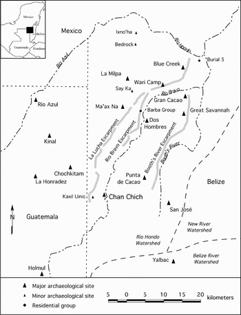
Chan Chich is in the south-central portion of the Three Rivers Region, a geographically defined study area in the east-central Yucatan Peninsula, straddling portions of the modern nations of Belize, Mexico, and Guatemala (Figure 1). Richard Adams (Reference Adams, Adams and Valdez1995:5) initially defined the region, and in the past decade the label has been widely adopted by researchers, particularly in northwestern Belize (e.g., Scarborough et al. Reference Scarborough, Valdez and Dunning2003). The area encompasses approximately 2,000 km2 (Adams Reference Adams, Adams and Valdez1995:5; Houk Reference Houk1996, Reference Houk and Houk1998a) and is home to more than a dozen medium-to-large-sized ruins, including Río Azul, La Milpa, La Honradez, and San José, in addition to Chan Chich (see Figure 1).
Map of the Three Rivers Region.

A series of three southwest-to-northeast trending escarpments marks the eastern edge of the Peten Karst Plateau (Dunning et al. Reference Dunning, Jones, Beach, Luzzadder-Beach, Scarborough, Valdez and Dunning2003:14). The La Lucha Escarpment, the western and highest of the three, separates the rugged La Lucha Uplands from the Río Bravo Terrace. Chan Chich is in the Río Bravo Terrace Lowland, a karstic region that has “weathered into a rugged landscape of ridges, conical hills, and irregular depressions, or bajos” (Dunning et al. Reference Dunning, Jones, Beach, Luzzadder-Beach, Scarborough, Valdez and Dunning2003:16). The site is located approximately 4 km east of the Guatemalan border, on the western bank of Chan Chich Creek. Several hundred meters north of the site, Little Chan Chich Creek and Chan Chich Creek meet to form the Río Bravo, which courses northward through the Río Bravo Terrace Lowland before following the base of the Río Bravo Escarpment on its way to join the Booth's River southeast of the site of Blue Creek. The divide between the Río Hondo and Belize River watersheds is about 18 km south of Chan Chich.
The site of Chan Chich was first recorded in 1988, and initial investigations included mapping the core area of the site and profiling looters' trenches (Guderjan Reference Guderjan and Guderjan1991a). The Chan Chich Archaeological Project (CCAP) mapped 1.54 km2 around the site in 1996 and conducted excavations in 1997–1999 and 2001 (Houk Reference Houk and Houk1998a, Reference Houk and Houk2000; Houk and Robichaux Reference Houk and Robichaux2003). For the most part, the CCAP excavations were small-scale testing studies of various features and components of the site. The unexpected discovery of Tomb 2 in the Upper Plaza, however, resulted in a large-scale excavation (Houk Reference Houk and Houk1998b:93).
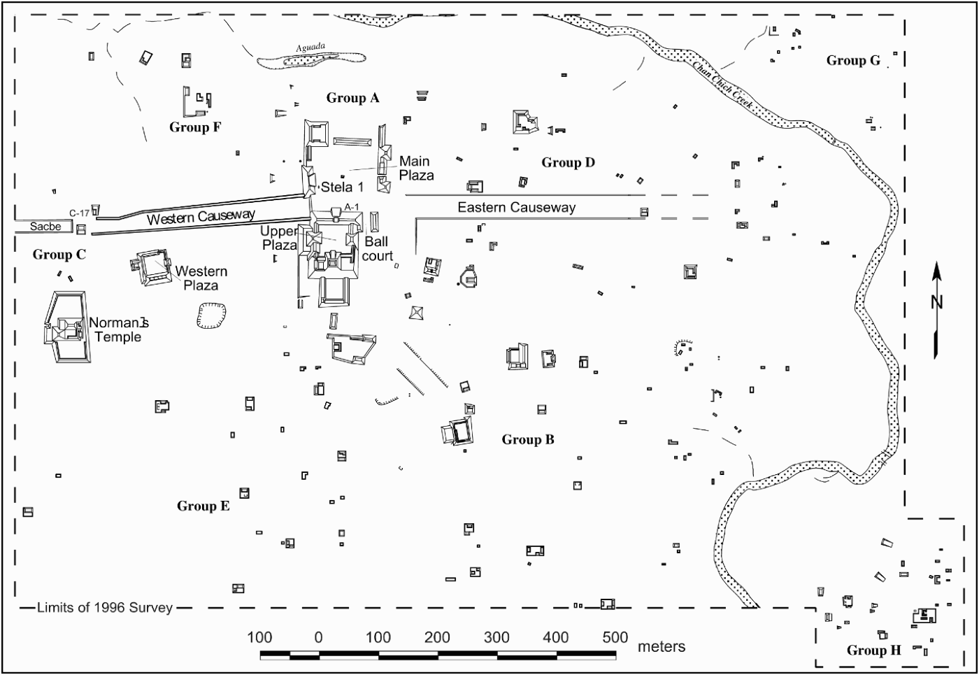
The major architecture at Chan Chich is clustered around the Main Plaza, a very large public space measuring approximately 110 m × 110 m (Figure 2). Examinations of now in-filled looters' trenches in the surrounding structures suggest that most of the visible mounds at the plaza were built during the Late Classic period (Guderjan Reference Guderjan and Guderjan1991a). CCAP test excavations encountered Late Preclassic period deposits beneath the plaza, indicating that the Late Classic constructions cover earlier architecture (Houk Reference Houk and Houk1998c, Reference Houk and Houk2000). The only known stela at the site, an uncarved and badly burned monument, is found on the western side of the Main Plaza.
Map of Chan Chich, Belize.
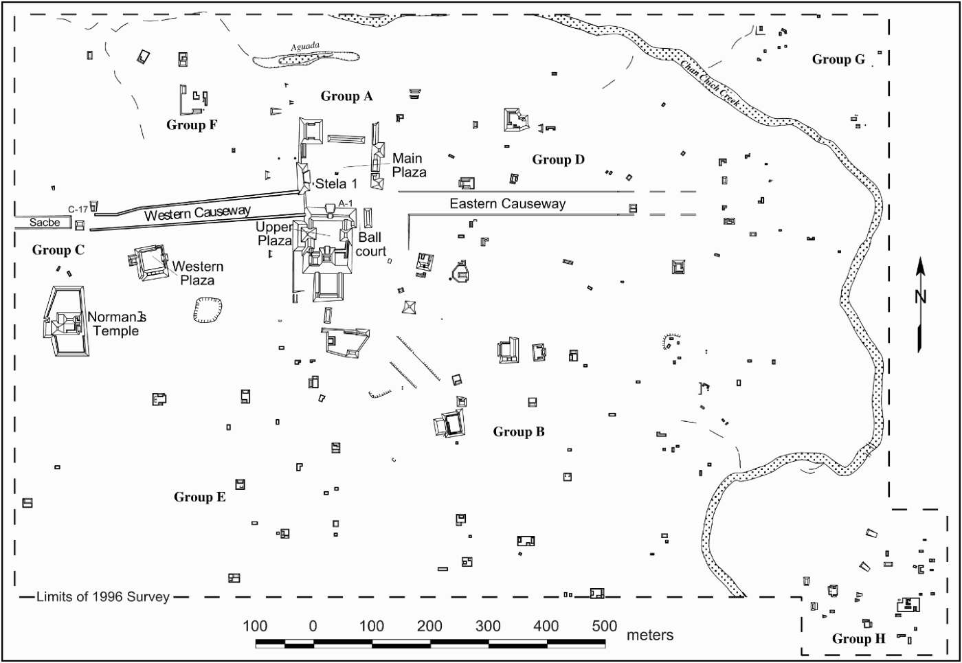
Structure A-1 is a massive range structure linking the Main Plaza on its north side to the Upper Plaza on its south side. During the Late Classic period, a wide stair on the north side of Structure A-1 and a broad landing in the center of the building provided access to the enclosed and restricted Upper Plaza.
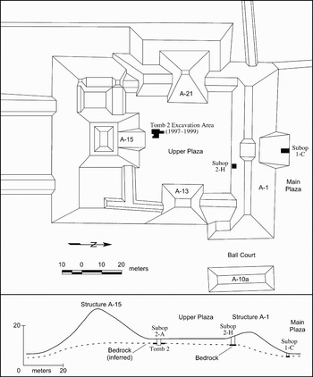
The Upper Plaza was constructed on a natural rise and has a long construction history (Figure 3). Within the plaza itself, excavations documented a Middle Preclassic period midden, dated to 770 cal. b.c. (Robichaux Reference Robichaux and Houk1998:34), and Tomb 2, dated to the Terminal Preclassic or beginning of the Early Classic period based on ceramic and other data. The larger surrounding structures, including Structure A-15, the tallest mound at the site, have looters' trenches revealing complicated construction sequences, probably beginning in the Late Preclassic period (Guderjan Reference Guderjan and Guderjan1991a:39; Houk Reference Houk and Houk1998b:94). Intensive study of the trenches and structures was not a major focus of the CCAP; however, previous researchers reported four separate construction episodes for Structure A-15 based on an examination of looters' trenches (Guderjan Reference Guderjan and Guderjan1991a:39). Of interest to this discussion are the earliest two phases. Structure A-15 Sub 3 was “a low platform buried by later construction, rising about 3 m above” the Upper Plaza (Guderjan Reference Guderjan and Guderjan1991a:39). On top of this platform “is at least one and probably two small temples, [Structure A-15 Sub 2], each about 4 m tall. Each contained at least one corbelled vault room with unpainted, plastered walls. [Structure A-15 Sub 2] would have appeared very much like Str. A-V at Uaxactun, which dates to the Early Classic period. Thus [the earliest two phases] may be the earliest public architecture at Chan Chich” (Guderjan Reference Guderjan and Guderjan1991a:39).
Map of excavations related to Tomb 2 and chronological test pitting with western cross section of the Upper Plaza.

TOMB 2
Discovery
The 1997 CCAP excavations focused, in large part, on establishing the construction history and chronology of the various plazas at the site, and project staff planned two test pits in the Upper Plaza, Suboperations 2-A and 2-H (see Figure 3). Suboperation 2-H, at the southern base of Structure A-1, documented seven floors spanning the Middle Preclassic through the Late Preclassic period capped by Late Classic period construction materials related to the final phase of Structure A-1. The earliest occupation found anywhere at the site was discovered in Suboperation 2-H. A Middle Preclassic midden and a posthole cut into bedrock marked this occupation, suggesting that the Upper Plaza was the early epicenter of site occupation.
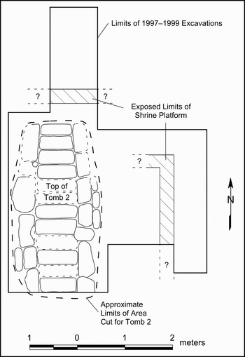
Suboperation 2-A was placed on the southern half of the plaza approximately 6 m north of Structure A-15 to test the plaza construction sequence and investigate a circular hole in the surface of the plaza. This hole, which was approximately 80 cm in diameter and had sides lined with large and irregular stones, extended 1.1 m below the surface of the plaza. Shortly after Suboperation 2-A was opened, the excavations were extended to encompass the hole, ultimately resulting in an irregular excavation area with final maximum dimensions of 4.2 m east-west by 3.0 m north-south. These excavations uncovered Tomb 2, exposed portions of a low shrine capping it, and revealed that the hole was the result of an ancient collapse of the roof of the tomb. Additional suboperations were opened in 1998 and 1999 to expand the tomb excavations (Figure 4).
Final extent of excavations at Tomb 2 showing the top plan of the tomb as well as the excavated portions of the shrine platform capping the tomb.

Upper Plaza and Tomb 2 Construction Sequence
Based on the 1997–1999 excavation data, during the Late Preclassic period the Upper Plaza comprised an artificial platform, likely bound at least on the north and south by the initial versions of Structures A-1 and A-15, respectively. We surmise, based on Guderjan's (1991a:39) description of the earliest phases of architecture, that Structure A-15 on the southern side of the plaza was a low platform supporting one or two temples during this period.
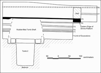
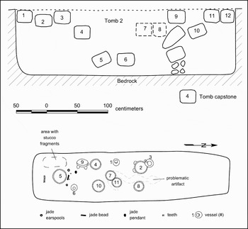
The Upper Plaza underwent at least three—possibly four—renovations during the Late Preclassic period, each accompanied by a new and higher plaza floor (Floors 1–4, from oldest to youngest). About the end of the Terminal Preclassic period, the Maya selected an area north of Structure A-15 to create Tomb 2. The Terminal Preclassic Maya excavated a pit through four Late Preclassic floors and 1.15 m into the limestone bedrock beneath to create the tomb (Figure 5). The tomb's chamber formed an ellipse approximately 3.25 m long and 0.8 m wide (Figure 6). The chamber was capped by 12 large capstones, which were plastered into place to span the roof of the tomb. An apparent wall of similar stones was found beneath the ninth capstone from the south and may indicate that the northern end of the tomb was an antechamber serving as the point of egress for the burial party. No grave goods were encountered north of the wall. After the tomb was capped, it was covered in dry-laid cobble fill. Perhaps significantly, the fill capping Tomb 2 did not contain alternating layers of chert debitage, which is a common trait of Early Classic tombs in the region (e.g., Adams Reference Adams1999; Guderjan Reference Guderjan2007; Hall Reference Hall and Adams1987, Reference Hall1989; Hammond et al. Reference Hammond, Tourtellot, Donaghey and Clark1996). It may be that Tomb 2 was constructed before the tradition of capping tomb shafts with chert debitage began or was introduced into the region. Finally, a low platform, measuring approximately 25 cm high was built over the tomb and surfaced with Floor 5. The platform capping the tomb was not fully excavated and may have been damaged by later renovations to the plaza. Its shape is unknown, but we estimate that it originally covered the entire tomb shaft and was centered above it. This platform apparently supported a low-walled room, and we interpret this to be a shrine marking the location of the tomb within the plaza. During the Late Classic period, as part of the final major renovation of the Upper Plaza, the shrine was entirely buried beneath Floor 6.
Northern cross section of Tomb 2 with floors (F) mentioned in text. Platform covering Tomb 2 shown in black.

Plan map of top of Tomb 2 (bottom) and western cross section of chamber (top).

At some point, erosion filled the tomb with a 15-cm-thick deposit of marly sediment that completely buried the articles on the floor of the tomb. The fifth and sixth capstones then collapsed, presumably after the site had been abandoned, allowing the rest of the chamber to fill with sediment and creating the hole observed in the modern plaza surface.
Excavation of Tomb 2
Discovered as it was during the course of plaza test pitting, Tomb 2 was a rather unexpected find in 1997, and the excavations were logistically and technically challenging. Nevertheless, the portion of the tomb containing artifacts and human remains was completely excavated in 1997, and subsequent excavations in 1998 and 1999 targeted the northern end of the chamber and attempted to clarify the stratigraphy of the plaza in the area of the tomb (Robichaux Reference Robichaux and Houk2000; Robichaux et al. Reference Robichaux, Jellen, Miller, Galien and Houk2000).
The infilling and subsequent collapse of a portion of the chamber's roof encased the artifacts and skeletal material in a tightly packed marl matrix. While this actually preserved the ceramic vessels to some degree—they would have been entirely crushed had the capstones fallen directly on the floor of the tomb—the marl proved to be a harsh, alkaline environment that accelerated the deterioration of organic material in the tomb.
Description of Tomb 2
Tomb 2 contained the badly preserved remains of an adult male, 11 ceramic vessels, four jade artifacts, a possible fragment of cotton paper, small fragments of stucco or paint, a small piece of wood, and a problematic artifact apparently made of wood. The artifacts and human remains were contained in the southern 2.15-m section of the tomb, south of an apparent wall separating the burial chamber from the possible antechamber at the northern end of the tomb (see Figure 6).
Skeletal Remains
Badly deteriorated human bone was recovered from 30 separate locations within the tomb, widely scattered across its floor. Given the nature of the deposit and the extremely fragmentary state of the remains, most of the skeletal material was recovered from screened matrix, provenienced by area, or from the matrix within vessels, which was excavated in the field laboratory. Four of the ceramic vessels on the tomb floor had bone within them, and some bone was also found resting on the rim of one vessel.
The tomb had a single occupant, a robust male in the age range of 30–45 years who was interred in an extended, supine position, with his head to the south (Robichaux Reference Robichaux and Houk1998). Aside from 16 teeth, no other diagnostic skeletal elements were identifiable except for several apparent rib fragments. Therefore age and sex determinations are based on limited data (Julie Saul, personal communication 1998). Thirteen maxillary teeth were found near the southern end of the tomb, marking the position of the skull. Three mandibular teeth were found 40 cm to the north, suggesting the mandible separated from the skull and fell or was otherwise moved to the chest area of the individual. Three of the recovered teeth were decorated. The right maxillary canine had a hematite insert and had been filed, matching Romero's (Reference Romero1970) G-15 modification. The right lateral incisor also had an apparent hematite insert but was not filed, matching Romero's (Reference Romero1970) E-1 modification. The left maxillary canine had been filed but had no insert, also matching Romero's (Reference Romero1970) C-5 modification.
The tomb floor was covered in many areas with a red pigment that may be cinnabar or powdered hematite, but it was not chemically analyzed. Six of the vessels had this material in the bottoms of their interiors. Four of the vessels in the center of the tomb (Vessels 4, 7, 9, and 10) had bone fragments within them. In each of these vessels the bone was resting atop the red pigment, but pigment was also present on the skeletal remains.
Julie Saul's (personal communication 1998) analysis suggests that the skeleton was still articulated at the time of burial. Bone was also found resting upon the rim of Vessel 5, indicating the tomb's occupant was interred on a low, perishable litter that was placed above the vessels on the tomb's floor. A similar inference concerning the presence of an elevated litter was made for an Early Classic tomb discovered at La Milpa, based upon the relationship of bone to ceramic furnishings within the tomb (Hammond et al. Reference Hammond, Tourtellot, Donaghey and Clark1996:89).
Ceramics
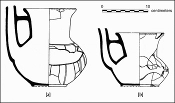
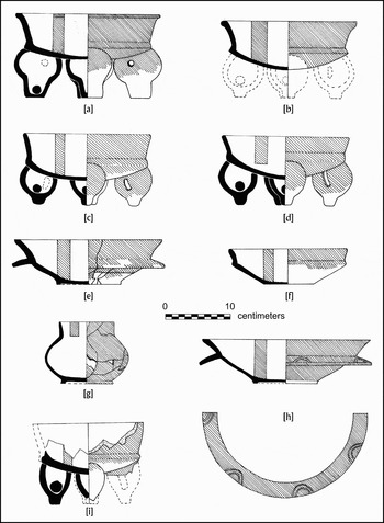
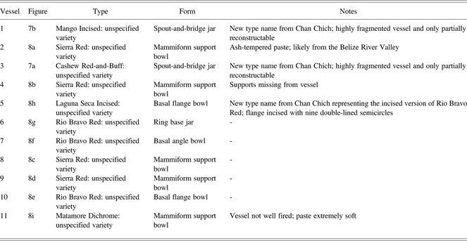
The tomb contained 11 whole vessels, differentially preserved depending on vessel form and wall thickness (Figures 7 and 8). Eight of the vessels were assigned to previously described types, and Valdez and Houk (Reference Valdez, Houk and Houk2000) proposed three new types for the remaining vessels (Table 1). In general, the assemblage of vessels represents in types, forms, and slips what is commonly observed in the Terminal Preclassic period. The vessels include five mammiform tetrapod support bowls, one of which was missing its supports, two spout-and-bridge jars, two basal flange bowls, a ring base jar, and a basal angle bowl. The ceramic types include those traditionally associated with the Chicanel Sphere, including Sierra Red and Matamore Dichrome, and perhaps the early Tzakol Sphere, such as Rio Bravo Red (e.g., Sagebiel Reference Sagebiel2005:247–253; Sullivan and Valdez Reference Sullivan and Valdez2006:79). The new types described based on vessels in the tomb were assigned to the Trogon Complex at Chan Chich, part of the Terminal Preclassic period, and include Laguna Seca Incised, the incised version of Rio Bravo Red; Mango Incised; and Cashew Red-and-Buff (Valdez and Houk Reference Valdez, Houk and Houk2000:130). The Laguna Seca Incised vessel is a basal flange bowl with a Sierra Red slip, highlighting the nature of the assemblage.
Spout-and-bridge vessels from Tomb 2. (a) Vessel 3, Cashew Red-and-Buff: Unspecified variety; (b) Vessel 1, Mango Incised: Unspecified variety (illustrations by Ashlyn Madden).

Remaining vessels from Tomb 2. (a–d) Vessels 2, 4, 8, and 9, Sierra Red: Unspecified variety; (e–g) Vessels 10, 7, and 6, Rio Bravo Red: Unspecified variety; (h) Vessel 5, Laguna Seca Incised: Unspecified variety; (i) Vessel 11, Matamore Dichrome: Unspecified variety (illustrations by Ashlyn Madden).

Whole Vessels and Type Names from Tomb 2
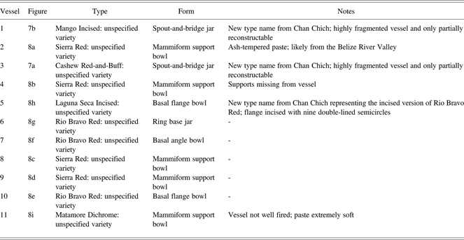
Vessel 2, a Sierra Red tetrapod bowl with large, flat mammiform supports, is unlike the other mammiform vessels in the assemblage. It is remarkably similar in size and form to Vessel 10 from a burial in Room 8 at Holmul, which was described by Hammond (Reference Hammond1984:Figure 2). The Holmul vessel was a polychrome bowl with a dead white fabric, which led Hammond (Reference Hammond1984:4) to suspect the vessel was an imported object. While no obvious paste differences were noted in the Chan Chich assemblage, it is possible the vessels were acquired from a variety of sources, as Hammond (Reference Hammond1984) suspected of the Holmul assemblage.
Given the poor preservation conditions in the tomb, no residue analyses were conducted on the Chan Chich ceramics. However, it is likely they contained food or beverage at the time of burial. Powis et al. (Reference Powis, Valdez, Hester, Hurst and Tarka2002) have shown that spouted vessels from the Late Preclassic period frequently were used as chocolate pots.
Jade
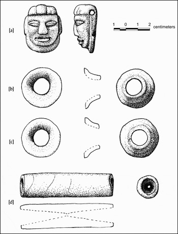
Four jade artifacts—two ear spools, one tubular bead, and a sculpted pendant—were found in Tomb 2 (Figure 9). The pendant is a helmet-bib head pendant (Proskouriakoff Reference Proskouriakoff1974:10), characterized by a helmetlike headdress and biblike object surrounding the lower portions of the face. The Chan Chich specimen has a three-part headdress, with a raised central element. Hammond (Reference Hammond1987:22), based on examples from Pomona, Cerros, and Nohmul, has argued that this form of helmet-bib head pendant is a “Preclassic sun god portrait.” The contexts in which the Cerros and Nohmul helmet-bib head pendants were found link them to the personages of the ajaw of the respective polities (Freidel and Schele Reference Freidel and Schele1988:552–558; Hammond Reference Hammond1987:23; Schele and Freidel Reference Schele and Freidel1990:102), and David Freidel (personal communication 1997) characterized the Chan Chich pendant as a “royal insignia jewel.”
Jade artifacts from Tomb 2. (a) helmet-bib head pendant; (b and c) ear spools; (d) bead (illustrations by Ashlyn Madden).

Proskouriakoff (Reference Proskouriakoff1974:11) has dated helmet-bib head pendants to the Preclassic period, and Hammond (Reference Hammond1987:22) and Schele and Freidel (Reference Schele and Freidel1990:98–121) more specifically assign them to the Late Preclassic. Helmet-bib head artifacts recovered from archaeological contexts at Cerros and Nohmul have been dated to around 100 b.c. (Hammond Reference Hammond1987:22). Several helmet-bib head pendants were found in a large cache at Blue Creek, dating from the end of the Early Classic period, approximately a.d. 500 (Guderjan Reference Guderjan2007:30–33); given their late date, they may represent heirloom pieces.
Other Artifacts
Owing to the harsh depositional environment, the other artifacts in the tomb were fragmentary and poorly preserved. They do, however, indicate that a wide range of artifacts was originally included in the burial. John Jones (personal communication 1998) identified a small (ca. 1 × 1 cm) fragment of “pressed Gossypium cotton paper” that has “blue and black brush strokes” on it. He suggests it “may be an old text fragment.” In some instances what appear to be the remains of ancient “codex” books in elite Maya tomb contexts have been reported from a few sites, including Copan, Honduras (Agurcia et al. Reference Agurcia, Fash and Garrett1989:483–486). The surmise that the small fragment in Chan Chich Tomb 2 is a codex fragment is consistent with the sun god pendant and is supportive of the royal status of the person buried in the tomb.
Near the southwestern corner of the tomb floor, to the side of where the head of the buried person is believed to have lain, excavators documented a large number of small, thin fragments of fragile material, which were green, red, or green on red. Observed edge on, the center of many of these fragments had a blackish color. The texture of the material seemed to be similar to flattened stucco. Examination of the material by John Jones (personal communication 1998) indicates the green and red material appears to have been painted onto a curved surface that had decayed. A reasonable possibility is that the material represents painted decorative elements on either a wooden vessel or gourd, which subsequently decayed and left the highly fragmented decorative material on the tomb floor. Similar cases were noted at Río Azul in Tombs 23 and 19 (Adams Reference Adams1999:53; Hall Reference Hall and Adams1987:132–133, Reference Hall1989:76–78), and Hammond et al. (Reference Hammond, Tourtellot, Donaghey and Clark1996:90) report a stuccoed “wooden or gourd bowl of which only part of the painted lining survives” from an Early Classic tomb at La Milpa. An alternative possibility, given the material's position in the tomb, is that it may represent decorative elements on a headdress made of perishable material.
A small fragment of possible Pinus sp. wood (John Jones, personal communication 1998) found near the tomb floor may be part of the burial litter or a fragment of some other artifact. This specimen, however, presents significant analytical problems. It was recovered from the screen during excavations because it was so encased in marl it was originally thought to be a small rock. The fragment measured 7.8 × 2.7 × 0.2 cm. The fragment of wood was submitted to Beta Analytic for radiocarbon dating, and the results were a millennium younger than expected: 530 ± 50 b.p. (Beta − 126352; wood; δ13C = −26.1‰). The calibrated age ranges of the sample are cal a.d. 1325–1340 and cal a.d. 1390–1460 (p = .95). Given the apparent Postclassic period age of the specimen, it is likely the wood was unrelated to the tomb; it was probably a piece of intrusive root. John Jones (personal communication 2008) notes that “some root morphologies produce features that mimic Pinus ‘wood’.”
A badly deteriorated, curvilinear object, thought possibly to be of wood, lay across the northern half of the tomb floor; again, the preservation conditions in the tomb adversely affected the artifact. In plan, it loosely resembled a curved staff or other implement, perhaps in the shape of a snake. Several samples were removed from the object for testing; however, the results were conflicting. Two experts consider the sample material to be bone (John Jones, personal communication 1998; Julie Saul, personal communication 1998). Beta Analytic, however, reported that during efforts to cleanse a sample of the object for dating, the material almost totally dissolved, leaving only a very small residue of woody pulp. This usually indicates that the sample has been poorly preserved and subjected to extreme conditions during its burial. The sample may retain its structure but very little of its content (R. E. Hatfield [Beta Analytic], personal communication 1998). Paul Francisco, a conservator at the former Department of Archaeology in Belize, examined the object in situ and removed a sample for microscopic analysis. He found that the upper surface of his sample was uneven and displayed consistent scrape marks. Furthermore, the specimen exhibited grains consistent with a hardwood, but that it appeared to be petrified—a finding consistent with Beta Analytic's. Francisco also identified four strands of blue thread, one strand of red thread, and one strand of grayish-green thread attached to the sample of the artifact that he examined under microscopic analysis (Paul Francisco, personal communication 1997).
Given the poor state of preservation and the conflicting results, analysis of the curvilinear artifact remains problematic. It could be part of the burial litter, the remains of a wooden staff or scepter or something altogether different, including a root fragment. However, based on the excavation data, the results of Beta Analytic's attempts to analyze the artifact, and Paul Francisco's observations, it is our conclusion that the artifact was most likely a carved artifact made of a tropical hardwood, probably a staff or scepter that originally had been adorned or decorated, as suggested by the strands of thread. A staff, particularly one with serpent-like characteristics, would be another symbol of rulership. Its shape and placement along the central axis of the tomb argue against the likelihood of its being a root, but that possibility cannot be completely dismissed.
Dating Chan Chich Tomb 2
The alkaline conditions of the marly sediment encasing the contents of the tomb were not conducive to good preservation of organic materials. Of the skeletal material, only teeth and small fragments of bone survived in the tomb at the time of discovery. The problematic artifact, apparently made of wood, had been essentially petrified; its organic matrix replaced by calcium carbonate. Two samples submitted for radiocarbon dating from the tomb were unsuccessful: one sample—from the problematic artifact—could not be processed, and the other returned a Postclassic period age. Therefore, the age of Tomb 2 can only be estimated based on the artifacts within it and from its stratigraphic position; both methods are largely dependent on relative dates of ceramic types and both point to a Terminal Preclassic/early Early Classic period age for the tomb's construction.
When the tomb was constructed, the builders cut through a series of Late Preclassic floors—defined by Chicanel ceramics in the subfloor fill—before excavating the tomb chamber into bedrock (see Figure 5). Sullivan and Sagebiel (Reference Sullivan, Sagebiel, Scarborough, Valdez and Dunning2003:Figure 3.1) estimate the date range of the Late Preclassic period in the region to be around 400 b.c. to a.d. 250. Tzakol 1 ceramics from the fill within the platform capping the tomb indicate a possible Early Classic period date for the tomb's excavation and the platform's construction. In the Three Rivers Region, the TR-Tzakol 1–2 ceramic complex dates to around a.d 250–450 (Sullivan and Sagebiel Reference Sullivan, Sagebiel, Scarborough, Valdez and Dunning2003:Figure 3.1).
The ceramic artifacts in the tomb have been assigned to the Trogon Complex at Chan Chich by Valdez and Houk (Reference Valdez, Houk and Houk2000:129), who noted “a significant overlap … between types” defined for the Jacamar Complex (Late Preclassic) and the Trogon Complex (Terminal Preclassic). As observed above, the assemblage of ceramics is Terminal Preclassic in slips and forms. The ceramic forms—bowls with bulbous mammiform supports, basal flange dishes, spout-and-bridge jars, and a jar with a ring base—are primarily “Facet 2” diagnostics of the protoclassic ceramic stage (e.g., Brady et al. Reference Brady, Ball, Bishop, Pring, Hammond and Housley1998:29–34), dating to around a.d. 150–400. The style of the jade pendant from the tomb has been dated to the Late Preclassic period, around 100 b.c. (Hammond Reference Hammond1987:22). The combined artifact and stratigraphic data, therefore, suggest the tomb was likely created at the end of the Terminal Preclassic or the very beginning of the Early Classic period in the region. We suggest that a.d. 200 to 350 is a reasonable estimate for the tomb's age.
EARLY ELITE AND ROYAL TOMBS IN THE REGION
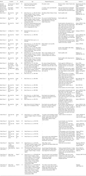
Blue Creek Burial 5 is arguably the earliest elite burial known in the region (Table 2); it was discovered in the very northeastern fringe of the Three Rivers Region, off of the Río Bravo Escarpment and approximately 4.25 km east of the site of Blue Creek (see Figure 1). The burial was discovered in a chultun in an elaborate residential group on a large hill rising out of the otherwise flat floodplain shared by the Río Hondo and Río Bravo. Above the tomb was a thick Late Preclassic midden that was apparently capped by an Early Classic period occupation. The burial included the remains of three individuals; 28 whole ceramic vessels; over 100 pieces of jade; an assortment of obsidian, hematite, and cloth fragments; and faunal and floral remains (Kosakowsky and Lohse Reference Kosakowsky and Lohse2003).
Reported and Suspected Late Preclassic–Early Classic Period Tombs in the Three Rivers Region

The 28 ceramic vessels belong to the Terminal Preclassic Linda Vista Ceramic Complex at Blue Creek (Kosakowsky and Lohse Reference Kosakowsky and Lohse2003). None of the pots are Usulutan vessels, but there are some trickle-style imitations in the collection—either organic resist or a wipe-off technique with double slipping, similar to Cimi ceramics from Tikal; Kosakowsky (personal communication 2003) notes some similarities with vessels from Nohmul, as well. Temporally and content-wise, Burial 5 appears to fall within the protoclassic Facet 1 according to Sagebiel (Reference Sagebiel2005:723), who observes that “it contained bowls, dishes, and jars (including one spouted jar) that either lack supports or have small supports that are Facet 1 diagnostics.” Brady et al. (Reference Brady, Ball, Bishop, Pring, Hammond and Housley1998:18, 33) suggest a range of 75 ± 25 b.c. to a.d. 150 for Facet 1, meaning Burial 5 may be a century or two older than Tomb 2 at Chan Chich.
Early Classic tombs (see Table 2) have been excavated in various contexts in the Three Rivers Region, including within or beneath temples and other types of structures at Río Azul (Adams Reference Adams1999; Hall Reference Hall and Adams1986), beneath the Main Plaza at La Milpa (Hammond et al. Reference Hammond, Tourtellot, Donaghey and Clark1996), under a residential structure west of the ball court at Dos Hombres (Durst Reference Durst1998; Sullivan and Sagebiel Reference Sullivan, Sagebiel, Scarborough, Valdez and Dunning2003), and at the rural Barba Group 2.5 km northwest of Dos Hombres (Hageman Reference Hageman2004; Sullivan and Sagebiel Reference Sullivan, Sagebiel, Scarborough, Valdez and Dunning2003). All of these tombs are regarded to be more recent than Tomb 2.
Burial 5 near Blue Creek is slightly older than Tomb 2 at Chan Chich. Its artifact assemblage may be an expression of prestige, but its rural location argues against its being an indication of power or rulership. It also represents the reuse of a chultun as a burial chamber, not the intentional construction of a specialized tomb.
The royal insignia jewel (the helmet-bib head pendant), the possible wooden scepter or staff, and Tomb 2's location within the heart of the site core argue for the individual's status as the ruler of the Chan Chich polity. Tomb 2, therefore, holds the distinction of thus far being the earliest royal tomb discovered in the Three Rivers Region as well as being the earliest constructed tomb in the region.
EARLY ROYAL BURIAL PATTERNS
With the exception of Burial B11.67 at La Milpa, all of the documented Early Classic tombs in the region were found in temples, palaces, or elite residential structures. We suggest that Chan Chich Tomb 2 follows an earlier tomb pattern, one in which rulers were interred not in temples, but in shrines in the center of their polities. The prototype for this pattern is found in the North Acropolis at Tikal, exemplified by the tomb of the founder, Yax Ehb' Xook. There are striking architectural similarities between the tomb of the dynastic founder at Tikal and Tomb 2 at Chan Chich.
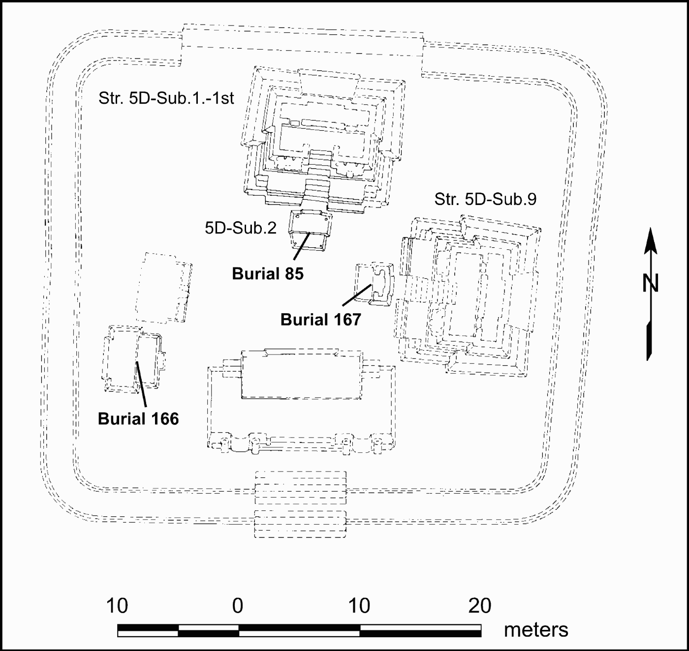
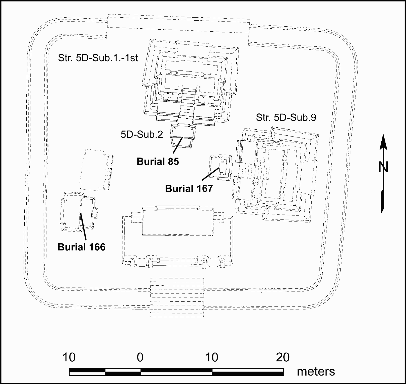
During the Terminal Preclassic period, two pyramids—Str. 5D-Sub.1-1st on the north and Str. 5D-Sub.9 on the east—were constructed on the North Acropolis. The pyramids were adorned with stucco masks flanking their central stairs and capped by two-room temples (Coe Reference Coe1990:210–214, 224–226, Figures 21, 22, and 29). Subsequently, tombs were excavated into the basal platform in front of the two temples, with a third tomb placed on the western side of the platform, and low shrines were constructed to cap the tombs (Figure 10). Sequentially, these burials began with Burial 166 in the southwestern corner of the Acropolis, included Burial 167 in front of the eastern temple, and concluded with Burial 85 in front of the northern temple (Coe Reference Coe1990:232).
Plan of the Terminal Preclassic period North Acropolis at Tikal showing the locations of Burials 85, 166, and 167 beneath shrines (after Coe 1990:Figure 10e).
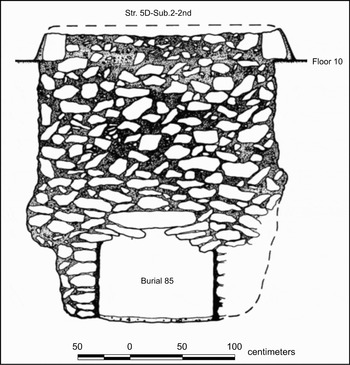
As discussed previously, despite the fact that the other two burials are earlier, Tikal Burial 85 is considered to be the tomb of the founder, and thus the first royal burial. As Coe (Reference Coe1990:217) describes the burial chamber of Yax Ehb' Xook, it was “cut through burned Fl. 10 as a rough rectangle (3.20 m north-south and 2.20 m east-west), the more or less vertically-walled excavation was carried down to 2.5 m and leveled off almost on bedrock” (Figure 11). The tomb chamber was then framed by four walls (0.70–1.0 m high), creating a floor plan 2.40 m long (north-south) by 1.10 m wide. The “mud-plastered lower side walls supported rustic vaulting of amorphous small slabs … spanned by six transverse stones, 0.80–0.90 m long; two had collapsed” (Coe Reference Coe1990:218). The tomb's shaft was filled with “dark earth (with bits of charcoal), stone rubble and blocks” and covered with Str. Sub.2.-2nd, a 0.40-m-high platform (Coe Reference Coe1990:217, 218).
North cross section of Str. 5D-Sub.2-2nd and Burial 85 (after Coe 1990:Figure 27b).

Yax Ehb' Xook was interred in a bundle with his head and femora missing. His tomb was stocked with 18 ceramic vessels from the Late Preclassic Cauac Ceramic Complex, the fuchsite mask noted above, a cylindrical jade bead, a stingray spine, various shell objects, a stuccoed wooden bowl, and various textile fragments (Coe Reference Coe1990:218–220). Coe (Reference Coe1990:220) comments that the tomb “by its sheer size must have been linked to Str. 5D-Sub.1-1st, patently the supreme edifice of the times. Surmised is that interment, so northerly and axially sited, either was for a man so prominent that he deserved it, or that he had played an outstanding role in the structure's evidently lengthy life.”
The significant differences between Burial 85 and Chan Chich Tomb 2 are their age, with Burial 85's being perhaps 100–200 years older, and the directional relationship between tomb and temple. However, the parallels are more informative. Both tombs were specially constructed chambers placed within the architectural heart of each site. Both were placed within the plaza in front of what are believed to be the largest temples at the time and then capped by low shrines. Finally, both Tikal Burial 85 and Chan Chich Tomb 2 housed early kings.
We suggest that Burial 85 and Chan Chich Tomb 2, though not contemporaneous, are both examples of an early royal burial pattern in the Lowlands in which rulers were buried not within funerary temples constructed by themselves or their heirs, but beneath shrines in front of the temples they used during life. During the Early Classic period, royal tombs began to be constructed differently: initially they were carved into bedrock beneath pyramids, and later they were constructed within the pyramids themselves. Commonly, lenses of chert debitage capped the Early Classic tomb shafts. Thus, Burial B11.67 at La Milpa may be viewed as a blending of the older pattern seen at Tikal and Chan Chich, in which tombs were placed near an associated temple, and the Early Classic pattern of capping tombs with chert debitage. Krejci and Culbert (Reference Krejci, Culbert and Grube1995:109) have previously noted a significant change in royal burial patterns, primarily in the contents of tombs, between the Manik 2 and Manik 3 ceramic phases at Tikal. It is possible the architectural and locational changes of Early Classic burials we are describing are another manifestation of the change Krejci and Culbert (Reference Krejci, Culbert and Grube1995) previously noted.
ELITE COMPETITION IN THE THREE RIVERS REGION AND BEYOND
Despite his apparent claims to divine kingship, the individual buried in Tomb 2 was likely one of many competing rulers vying for power in a rapidly changing political landscape. This competition in the region began sometime earlier, and the unusually rich Burial 5, near Blue Creek but over 4 km from the site center, is a sign that political relationships may have remained contested around the peripheries of the growing sites. Chan Chich Tomb 2 and Burial 5 from near Blue Creek are early examples of elite participation in a burgeoning and competitive political arena.
Initially, elite people like the king at Chan Chich and the primary individual buried in Burial 5 adopted “a political and/or ritual subcomplex” of ceramics (Sagebiel Reference Sagebiel2005:723)—which constitutes the protoclassic in the Three Rivers Region—to express their participation in this regional political arena. This ritual subcomplex included mammiform tetrapods. Chan Chich Tomb 2 is one of a handful of examples that Reese-Taylor and Walker (Reference Reese-Taylor, Walker, Masson and Freidel2002:106) describe as “Holmul I” style tombs, “a group of architecturally and materially distinct tombs … in northeastern Petén and northwestern Belize.” They observe that these tombs contain mammiform tetrapod vessels, “made in a variety of forms and surface treatments,” with basal flange bowls, spouted jars, and other forms (both standard and special), as well as jade, Spondylus shell, and other imported prestige goods (Reese-Taylor and Walker Reference Reese-Taylor, Walker, Masson and Freidel2002:107).
It is our position that the pattern noted above is one of the early ways that the elite and newly founded royal dynasties of the Central Lowlands expressed in death the competition for power and prestige that undoubtedly marked their political lives. Through time—as the region entered and passed through the Early Classic period—the competition among rulers/powerful elite manifested itself more dramatically through (1) monumental construction at some sites and (2) a more diverse system of “exchange of luxury goods and/or local emphasis on symbols associated with powerful sites from afar” (e.g., Sullivan and Sagebiel Reference Sullivan, Sagebiel, Scarborough, Valdez and Dunning2003:31) at others. The former is perhaps best typified by the significant expansion of monumental architecture at Río Azul (which grew quickly to be a dominant site in the region), La Milpa, and Blue Creek. At Río Azul, the first construction of palace structures occurred at the beginning of the Early Classic period, and the initial phase of the massive A-3 complex of five temples began around a.d. 385 (Adams Reference Adams1999:42). At La Milpa, there was “substantial growth during the Early Classic, much of it in Plaza A, including the plaza itself and the monumental buildings on it,” and at least seven stelae were erected in Plaza A during the Early Classic (Sagebiel Reference Sagebiel2005:726). At Blue Creek, the Early Classic was a period of dynamic architectural growth and innovation (Driver Reference Driver2007). While the initial expansion of the site core was rather modest, the latter half of the period witnessed an extensive rebuilding episode during which a large, colonnaded building and a temple adorned with a stucco panel were built (Driver Reference Driver2007).
CONCLUSIONS
Tomb 2 at Chan Chich provides early evidence relating to the establishment of rulership at a site in the Three Rivers Region. It also reflects the identification on the part of the local elite with the developing trappings of rulership in the wider arena of the Maya Lowlands. Tomb 2 emulated in placement and construction Tikal Burial 85, and its occupant was interred with one of the first symbols of royalty to appear in the Maya lowlands—the royal insignia jewel worn on the headbands of kings. Participation in this political arena was expressed regionally by the use of protoclassic ceramics and other exotic artifacts (jade, shell, obsidian, etc.) in burial contexts. Through time, this competition changed to include specialized tomb construction, dramatic expansion of monumental architecture, the use of stucco adornment on buildings, and a wider range of exotic artifacts, which were placed in caches, as well as burials.
Chan Chich Tomb 2 follows a Late Preclassic royal burial pattern, perhaps originating at Tikal, in which early kings were buried beneath shrines in front of their principal structure, rather than within a funerary temple. From a research perspective, it is possible that early royal burial customs in the Central Lowlands may be more diverse than commonly believed. Important information about the early history of dynastic lineages at other sites may lay undiscovered in tombs beneath plazas rather than within pyramid platforms. The seeming scarcity of Terminal Preclassic and early Early Classic period tombs may, therefore, be at least partially attributable to excavation bias.
RESUMEN
Chan Chich es un sitio arqueológico de los Mayas antiguos localizado en el noroeste de Belice. Es de tamaño mediano, y fue ocupado desde el preclásico medio hasta el clásico tardío. En 1997, el Proyecto Arqueológico de Chan Chich encontró una tumba tallada en la roca madre, debajo de una plaza situada en el centro del sitio. La tumba fue designado Tumba 2. Artefactos descubridos dentro de la tumba, y la estratificación presente, indicaron que la Tumba 2 fue construida cerca del fin del preclásico tardío o al principio del clásico temprano, en torno a d.C. 200–350.
Para construir la tumba, los Maya excavaron a través de una serie de pisos del preclásico tardío, y en la roca madre abajo. La cámara de la tumba fue 3,25 m de largo y 0,8 m de ancho y fue cubierta por 12 grandes piedras rectangulares. La tumba contuvo los restos mal conservados de un hombre adulto, 11 vasijas de cerámica, cuatro artefactos de jade, un posible fragmento de papel de algodón, unos pequeños fragmentos de estuco o pintura, un pequeño pedazo de madera, y un artefacto hecho probablemente de madera. Un colgante de jade indica que la tumba es un entierro real. Las cerámicas en la tumba incluyen formas típicamente asociadas con el “protoclassic” en el norte de Belice. La tumba fue debajo de una plataforma baja que probablemente sirvió como un santuario. La evidencia indica que la Tumba 2 de Chan Chich representa la primera tumba real conocida en la región, y que la tumba refleja un nuevo modelo de competencia entre élites en las Tierras Bajas Central de los Mayas antiguos. Esa competencia comenzó al principio del preclásico y se intensificó y se transformó durante los periodos preclásico tardío y el clásico temprano. Hay una fuerte semejanza entre la Tumba 2 de Chan Chich y el Entierro 85 de Tikal, la tumba de Yax Ehb' Xook, el fundador de la dinastía de Tikal.
Finalmente, observamos que, debido a la tendencia de arqueólogos a buscar tumbas reales dentro y bajo pirámides, y no bajo el superficie de plazas, es bien posible que los reyes del preclásico tardío fueron mas numerosos que anteriormente fue creído.
ACKNOWLEDGEMENTS
The authors wish to thank all the students and staff of the Chan Chich Archaeological Project who participated in the discovery, excavation, and analysis of Tomb 2 during the 1997–1999 seasons. Ashlyn Madden illustrated the artifacts from the tomb, Dr. Frank Saul and Julie Saul examined the skeletal material for us, and Dr. John Jones analyzed a number of special samples from the tomb. Audra Pineda Strubbe served as our laboratory director in 1998 and edited this manuscript. We are grateful to John Miller and Alexandra Miller, who not only donated a vehicle to the project but also made a generous gift to support the tomb's analysis in 1997. The Foundation for the Advancement of Mesoamerican Studies, Inc., partially funded the analysis of the tomb in 1997 through an emergency grant (No. 97004), as did the National Geographic Society. The students involved in the project were participating in an archaeological field school run through Trinity University, and we would like to thank Dr. John Donahue for making that possible. The research could never have happened without the support of Tom and Josie Harding, Norman Evanko, the staff of Chan Chich Lodge, and Barry Bowen, the landowner. The research was conducted under a permit issued by the former Department of Archaeology (DOA), Government of Belize. We would like to thank the staff of the DOA (now Institute of Archaeology) at the time, including Dr. John Morris, Dr. Allan Moore, Brian Woodeye, Paul Francisco, and Carmen Blanco. Finally, we would like to thank the following individuals who provided comments on various versions of this manuscript: Dr. R. E. W. Adams, Dr. James Brady, Dr. Norman Hammond, and Dr. Laura Kosakowsky.