The Qajuuttap Sermia glacier system
Johan Dahl Land is an ice free upland located at 61°18′ to 30′N, and 45° to 46°W in south Greenland, bordering the southern margin of the Greenland ice sheet (the inland ice; Fig. 1). This upland region continues northwards beneath the inland ice, with peaks of a buried alpine landscape forming nunataks that reach over 2000 m above sea level (asl).
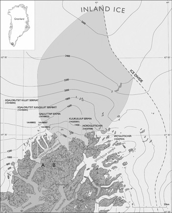
Area of Qajuuttap Sermia glacier system. The approximate area of the glacier system is marked as a grey shading showing its location on the western side of the south dome of the inland ice. The equilibrium line is situated at 1550–1600 m asl at Kuukuluup Sermia, where it was measured in 1979–1980 to 1981–1982 (Clement Reference Clement1983a: 25). The code numbers of the individual glacier lobes are given, together with their names (if any). The letter A marks the location of Qajuuttap Ilua, B the valley of Qajuuttap Ittinera that extends from the head of Sermilik ice fjord at the front of Qajuuttap Sermia glacier (in the west) to the head of Tunulliarfik fjord (in the east). The question mark added to Eqalorutsit Kangillit Sermiat? is to indicate it was an earlier name for Qajuuttap Sermia (see text). Map base: S. Ekholm.

Drainage of this sector of the inland ice is concentrated in the large ice stream of Qajuuttap Sermia, which calves a few cubic km ice/year into Sermilik ice fjord (Weidick and others Reference Weidick, Williams and Ferrigno1995). In addition to the major glacier lobe draining into Sermilik, two further glacier outlets drain the south side of Qajuuttap Sermia: Kuukuluup Sermia and Nordgletscher, located respectively 25 km and 40 km behind (east of) the front of Qajuuttap Sermia (Fig. 1). Both these glaciers drain through valleys in eastern Johan Dahl Land and ultimately into Tunulliarfik fjord. These three glaciers, together with the sector of the ice sheet they drain, make up ‘the Qajuuttap Sermia glacier system’. In contrast to the neighbouring parts of the inland ice margin in south Greenland, to the west and southeast, these outlets have all advanced throughout the last half of the 20th century.
The Qajuuttap Sermia glacier system covers an area of about 5000 km2 (Fig. 1), of which only 11% forms the ablation area. The equilibrium line has been determined at Kuukuluup Sermia at approximately 1550 m asl (Clement Reference Clement1981: 49); the precipitation over the area of the Qajuuttap Sermia glacier system is estimated by Ohmura and Reeh (Reference Ohmura and Reeh1991) as between 80 and 90 cm water equivalent.
Exploration history and place names
The only known description prior to World War II is of a visit to the western coastal parts of Johan Dahl Land in 1894 (Moltke and Jessen Reference Moltke and Jessen1896). From the interior parts of ‘Nordre Sermilik Fjord’ (now Sermilik, Fig. 1), Qajuuttap Sermia was observed and described from a distance, including the median moraine at the junction between the main glacier and a lower tributary joining it from the west (1AH08002). Historical information for other parts of the inland ice margin is essentially restricted to the period during and after World War II. A description of the glacier changes up to 1955 was given by Weidick (Reference Weidick1959), with updates for 1967–1976 by Metcalfe (Reference Metcalfe1969) and Jenkins (Reference Jenkins1980), for 1977–1983 by Clement (Reference Clement1981, Reference Clement1982, Reference Clement1983a) and for the period up to 1989 by Warren (Reference Warren1991) and Warren and Glasser (Reference Warren and Glasser1992). The rate of movement has been determined along a single profile over Qajuuttap Sermia at 600–700 m asl and approximately 20 km from the front (Knudsen Reference Knudsen1983: 117); maximum movement was here 1500 m/yr. The movement rate of Kuukuluup Sermia was determined to be a maximum of 100 m/year (Clement Reference Clement1981: 36; Reference Clement1983a: 42) and at 1100 m asl, close to the split of Nordgletscher from Qajuuttap Sermia, the movement direction was southwestwards at 245–385 m/yr (Clement Reference Clement1983a: 42).
Most glaciological data were collected during glacier-hydrological investigations related to the hydropower potential of the Johan Dahl Land area (estimated potential: 300GWh according to Nukissiorfiit 1955). The project was carried out by the Geological Survey of Greenland (GGU), and extended over the years 1977–1983 with Paul Clement as leader. Although most studies were focused on Kuukuluup Sermia, it was clear from the beginning that the glacier changes observed were connected to the whole Qajuuttap Sermia glacier system (Weidick Reference Weidick1963: plate 1). Investigations were therefore extended to the neighbouring glaciers, and included an evaluation of the ice cover thickness in the central part of the Qajuuttap Sermia glacier system.
In this article Greenlandic place names follow the new authorised spelling introduced in 1973, but the pre-1973 spelling is retained for established stratigraphic terms (for example Narssarssuaq stade, named after the locality now spelt Narsarsuaq) and in citations from older sources (for example the spelling of Kajutaq, now Qajuuttaq).
With respect to the glaciers described here, some have formal approved names while others have none. However, in their glacier inventory and atlas, Weidick and others (Reference Weidick, Bøggild and Knudsen1992) distinguished all glaciers in south and west Greenland by an eight digit code (see also Fig. 1). The first digit (here 1) indicates western Greenland, the following letter gives the district (here A), and another letter (here H: Sermilik fjord or G: Tunulliarfik fjord) denotes the related fjord; the following two digits indicate the number of hydrological basins in the fjord and the final three digits indicate the number of the glacier (or for the inland ice margin, the outlets in the basin).
Individual outlet glaciers
For glacier fronts ending in fjords (Qajuuttap Sermia) or in lakes (Kuukuluup Sermia) the seasonal fluctuations can veil the general trend of advance. Although most observations have been made in the summer (July to September), significant seasonal variations in frontal positions may occur within this period, and it must be borne in mind that total advances of all the glaciers during the 74 years of local observations (1932–2006) amount to only about 1600 m. This implies an average rate of advance during this period of only approximately 22 m/year at most. In this article, information derived from vertical aerial photographs covering a whole glacier snout is regarded as most reliable, whereas local more detailed observations can often only be fitted with difficulty into the general scenario of glacier changes. For the individual glaciers, centre line frontal positions are estimated from the scattered information available on the fronts. For the purposes of description observations are localised to four areas: (1) the front of Qajuuttap Sermia with its tributary 1AH08002, (2) the tributaries 1AH08007 and 1AH08016, (3) Kuukuluup Sermia and (4) Nordgletscher.
Early observations (1854–1932) can only be given for Qajuuttap Sermia. Newer observations (1940–2006) are collectively divided into decades for each area, to facilitate comparisons between the four areas.
Qajuuttap Sermia and tributary 1AH08002
Qajuuttap Sermia is a tidal, calving glacier. No distinct grounding zone can be observed, and bottom conditions of the glacier are only known for a restricted number of soundings made from the glacier surface at altitudes of 1000–1500 m asl. (Clement Reference Clement1983b: 21, Fig. 4.3). Basal conditions of the lower part of the glacier and of the adjoining Sermilik ice fjord are unknown.
Of the names that have been used for this glacier (Eastern Sermilik Glacier, Moltke and Jessen Reference Moltke and Jessen1896; Eqalorutsit Kangilliit Sermiat, Weidick Reference Weidick1959, Reference Weidick1963), the name Qajuuttap Sermia (= Qajuuttaqs glacier) is preferred here, since it is the name used by the local population (Hanseraq Frederiksen, personal communication, 1955) and was later applied by Petersen (Reference Petersen1979), and it is also the name that appears on recent maps of the area. This name may also relate to the recorded history of the area. The mineralogist K. L.Giesecke wrote in his diary of 2 August 1809, that he had met a heathen Greenlander by the name of Kajutak, who in the winter lived at Narsaq (now a town near Sermilik fjord, about 50 km southwest of the front of Qajuuttap Sermia) (Giesecke Reference Giesecke1910: 219–220). The hunting grounds of Kajutak (= Qajuuttaq) in the summer were evidently in the surroundings of the head of Sermilik fjord, since a number of localities applied by the local population still carry this name. Hansen (Reference Hansen1999: 70) notes the usage of the place names ‘Qajuuttap Itinnera’ (= Qajuuttaqs passage) and ‘Qajuuttap Ilua (= Qajuuttaqs inlet). And on more recent maps ‘Qajuuttap Nunaa’ (= Qajuuttaqs land) can also be seen. Giesecke's diary also notes the occurrence of Norse ruins buried by the advancing ice, but unfortunately does not record the exact location of the sites.
It is possible that the former place name for the glacier Eqalorutsit Kangilliit Sermiat (= ‘The eastern glacier of the poor salmon places’) is misplaced on maps and should be placed closer to its western large neighbour: Eqalorutsit Killiit Sermiat (= ‘The western glacier of the poor salmon places’; see Fig. 1). At Eqalorutsit Killiit Sermiat a recession of the main glacier after 1894 (compare Moltke and Jessen Reference Moltke and Jessen1896) led to a split of the glacier into two branches, of which the eastern arm may be the real ‘Eqalorutsit Kangilliit Sermiat’ (Weidick Reference Weidick1984, Reference Weidick1988b; see also Fig. 1).
1854 and 1855
The head of Sermilik is shown on a map sketch by P. Motzfeldt (preserved in The Royal Library, Copenhagen) and by H. Rink (Bak Reference Bak and Fisker1981: 78). The maps show only that the glacier front is well inside the eastern branch of the head of Sermilik icefjord, although the exact position is not determinable.
1894
C. Moltke and A. Jessen visited the head of Sermilik from June to September 1894 (Moltke and Jessen Reference Moltke and Jessen1896). The glacier front was observed from the area at about the junction between the inner western and eastern branches of Sermilik icefjord, that is about 15 km southwest of the glacier front (Fig. 1). They recorded that Qajuuttap Sermia is fed by tributary glaciers that drain through passages in a group of nunataks; these must be 1AH08002, 1AH08007 and 1AH08016 that drain into the main trunk of 1AH08022 (Qajuuttap Sermia proper; Fig. 1). In their description of this glacier (Moltke and Jessen Reference Moltke and Jessen1896: 100–101) record as follows.
Along the eastern margin of the glacier a very large marginal moraine can be seen, which covers large parts of the glacier itself. From the west come two glaciers down to the main glacier between the nunataks, of which the lowermost one is highly crevassed and markedly compressed, and carries a well-defined marginal moraine traceable down the western side of the main glacier. The actual glacier front was hidden by icebergs in June, but at the end of September was well-defined, in its western parts with fresh, vertical fractures, while its eastern part sloped down to the water without fracturing. The icebergs in front of the glacier were generally covered by gravel and boulders, but with the material situated on the surface and not within the ice.
There is no sign of this eastern moraine in any of the 20th century photographs of Qajuuttap Sermia.
Although the glacier was observed at a great distance, the observations and the map sketch indicate the western part of the front to be situated a short distance from the junction between tributary 1AH08002 and the front of the main glacier. The description of frontal differences from June to September may be seasonal variations.
1932
Professor Gudmund Hatt visited the valley south of the front of Qajuuttap Sermia during a botanical and archaeological survey in August 1932, that was related to the evaluation of the agricultural basis for Norse farming. This was the first time that the valley and the two Norse ruin groups found there were described and investigated. Unfortunately little has been published from this expedition, and it was only in 1999 that some details of the expedition were described on the basis of archive material and archaeological studies in south Greenland by S. S. Hansen (Reference Hansen1984, Reference Hansen1999). Hatt had originally used the name ‘Nordbovig’ (= Norse inlet) for the bay south of the glacier, and ‘Nordbodalen’ (= the Norse valley) for the valley with the Norse ruins. The names have subsequently been changed to Qajuuttap Ilua and Qajuuttap Itinnera respectively (Hansen Reference Hansen1999: 70), and are indicated here as A and B in Fig. 1.
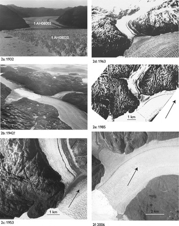
A 1932 photograph of the glacier was presented to the author by Hatt after his glaciological reconnaissance of the area in 1955, and was published with a description of the locality by Weidick (Reference Weidick1959; see also Fig. 2a). The photograph shows the front of Qajuuttap Sermia, from a point 510 m asl on the eastern (left) side of the front, looking directly northwest to the lower tributary (1AH08002). The position of the right part of the front of Qajuuttap Sermia seems to be close to headland C (in Fig. 3) and about 1 km south of its junction with the south side of 1AH08002. A very narrow trim line zone in the lower parts of the tributary glacier 1AH08002 is just visible. The left (eastern) front of Qajuuttap Sermia cannot be seen on the photograph, but is estimated to be 1–1.5 km north of headland D (see Fig. 3).
Changes of the front of Qajuuttap Sermia (1AH8022) and the lower tributary (glacier 1AH08002, no name). The development of the expansion of the northwestern flank of Qajuuttap Sermia into the valley of 1AH08002 can be followed on the photographs, a.1932. Presumably taken in August (Hansen Reference Hansen1999: 68), photo G. Hatt. Glacier front and tributary from the east., b.1942. 23 July 1942. KMS B34 A-L, no. 65, oblique aerial photograph, looking from the southeast., c. 1953. 2 September 1953. KMS 201 F no. 12900, vertical aerial photograph., d. 1963. 17 June 1963, KMS 267 F-N no. 266. oblique aerial photograph, looking from the southwest., e. 1985. 7 August 1985. KMS 887 H no. 4219, vertical aerial photograph. . f. 2006 10 August 2006. GEUS-Scankort. Vertical aerial photograph.

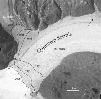
Frontal region of glaciers 1AH08022 (Qajuuttap Sermia) and its tributary 1AH08002 shown on the aerial photograph of 2006 (10 August 2006, GEUS-Scankort). Letters indicate the characteristic headlands of A, B, C and D. The letter Ø marks a small island at the front of Qajuuttap Sermia. Frontal positions of Qajuuttap Sermia and the median moraine between this glacier and tributary 1AH08002 are shown for the years 1953 (from KMS 201 J no. 12469, 21 August 1953) and 1981 (from KMS 880 A no. 1621, 10 August 1981).

Hatt (Hansen Reference Hansen1999: 69) considered that the two Norse farms in Qajuuttap Itinnera would scarcely support two families under present day conditions, and suggested that access to the farms from Sermilik may have formerly been easier with lesser amounts of calf ice in the fjord. Hatt also adds for Qajuuttap Sermia (Hansen Reference Hansen1999: 70) that it ‘seems that the glacier is receding’.
The description from 1894 and the photograph from 1932 are indicative of similar frontal conditions of Qajuuttap Sermia, and perhaps general stability of the glacier front at this time.
1940–1949
This decade is represented by oblique aerial photographs from 1942 and 1947. During the war years the United States Air Force flew a series of trimetrogon aerial photographs over all of Greenland; each route comprises a vertical set of photographs and two oblique photographic sets left and right of the line of flight. The routes covering Qajuuttap Sermia were flown in either July 1942 or 1943, hereafter referred to as 1942. Comparisons with the later photographs from 1953, suggest a slight advance may be attributed to this decade. The median moraines on the surface of tributary 1AH08002 are cut off by the main glacier of Qajuuttap Sermia without significant deformation.
1950–1959
The decade is represented by vertical aerial photographs taken in 1953, and a description and photograph of the glacier from 1955 (Weidick Reference Weidick1959). At the western flank, a slight deformation of the median moraine between Qajuuttap Sermia and 1AH08002 can be seen on the photograph from 1953, indicating an initial advance of Qajuuttap Sermia of approximately 300 m into the valley occupied by 1AH08002 (compare Fig. 3). On its eastern flank, Qajuuttap Sermia is expanding, and 1955 observations show pressing up of old soil and vegetation (Weidick Reference Weidick1959).
1960–1969
The information for this decade comprises an oblique aerial photograph taken in 1963 and a systematic survey and description undertaken by Brathay Exploration Group in 1967; the same group carried out a re-survey of the area in 1972 and 1976 (Jenkins Reference Jenkins1980).
The western flank of Qajuuttap Sermia appears to have advanced some 300–400 m into the valley occupied by 1AH08002 since 1953 and up to 1967 (compare Fig. 2d, 1963). The tributary was undergoing thinning from 1932–1967 (Jenkins Reference Jenkins1980: 16, 19, Fig. 2.2), and the height of the trim line zone in the lower part of 1AH08002 was for 1967 given as over 100 m. In 1932 the trim line was very narrow. The entire front of Qajuuttap Sermia in Sermilik fjord was surveyed during the 1967 investigations, and was shown as very lobate (perhaps due to recent calving) in contrast to its appearance on most aerial photographs from other years.
1970–1979
A re-survey of the front of Qajuuttap Sermia in 1976 (Jenkins Reference Jenkins1980: 14–15; Clement Reference Clement1981: 37) showed major changes in frontal positions since 1967. The western flank had advanced 630 m towards the south and the eastern flank 230 m southwards; central parts of the front were, however, almost unchanged in position probably due to calving. The ice observed attached to the mountain slopes may indicate remnants of a winter advance.
On the east side of the glacier, approximately 2.5 km north of headland D (Fig. 3), the side of the glacier had expanded into the mountain slope by about 36 m in the period 1955–1967; a further expansion of approximately 10 m is stated for the period 1967–1976 and furthermore in the period 1976 to 1980 an expansion of about 15 m occurred (Clement Reference Clement1981: 37).
The thinning of the tributary lAH08002 on its west flank is presumed to have continued, since by 1981 Qajuuttap Sermia had penetrated the valley of lAH08002 for a distance of nearly 700 m (since 1953). The western part of the front reached headland B, probably in the early 1970s, while the eastern part of the front was then approaching headland D (Fig. 3).
1980–1989
Information available for this decade comprises a 1980 photograph taken from a helicopter, vertical aerial photographs from 1981 and 1985, and a survey and description for 1989 given by Warren and Glasser (Reference Warren and Glasser1992).
On its western flank, Qajuuttap Sermia seems since 1981 to have advanced a further 200 m into the valley of 1AH08002 (aerial photograph of 1985), and the west part of the front had advanced to a position south of headland B. By the end of the decade (1989) the east part of the front was close to the island south of the glacier front (marked ‘Ø’ in Fig. 3). The increase in width of the glacier on the eastern side of Qajuuttap Sermia was not determined for this or subsequent decades.
1990–1999
No photographic information covers the glacier events of this decade. Comparison of the 1989 survey with the satellite image of 2000 shows that the western part of the front of Qajuuttap Sermia had advanced to fill the bay between headlands A and B (Fig. 3), and the eastern part of the glacier front had advanced to reach the island of Fig. 3.
2000–2006
Information for this period is limited to a satellite image from 2000 and vertical aerial photographs taken in 2006. The frontal positions of Qajuuttap Sermia for 2000 and 2006 are almost identical; the glacier front in both years extends from headland A on the west side of the glacier to the small island (marked ‘Ø' in Fig. 3) south of the eastern flank of the front. It would seem that the continuous advance of Qajuuttap Sermia since the early 1940s may finally have ceased after 2000. Examination of future satellite images should confirm whether the front remains stationary or begins to retreat. The halt of the present front of Qajuuttap Sermia at a widening of the fjord may be related to the morphological conditions of the surroundings, where a ‘nailing’ of the position of the glacier front to the fjord sides is related to change in width of the fjord (Mercer Reference Mercer1961).
Since 1953 and to 2006 the western flank of Qajuuttap Sermia has intruded approximately 1300 m into the valley of tributary 1AH08002.
Tributaries 1AH08007 and 1AH08016
These two tributaries are situated on the northwestern side of Qajuuttap Sermia, respectively 11 km (1AH08007) and 13 km (1AH08016) upstream from the front of this glacier (see Fig. 1). The glaciers are about 1.5 km (1AH08007) and 1.0 km (1AH08016) wide. As is the case for 1AH08002 and other parts of the southern slope of the inland ice, these glaciers can be presumed to have been characterised by a thinning, initiated in the last half of the 1800s, and with an increased rate of the thinning and recession during the 1900s.
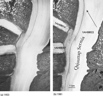
In the decade of 1940–1949 oblique aerial photographs from 1942 and 1946 show a deformation of the snouts of the tributaries 1AH08007 and 1AH08016. They are bent at a right angle at the junction with Qajuuttap Sermia. Figs. 4(a) and 4(b) show the following development between 1953 and 1981, in which the expansion of Qajuuttap Sermia causes the bended parts of the tributaries to diminish gradually. On the aerial photograph from 1981 (Fig. 4(b)) the bent parts of the tributaries are hardly discernible and they cannot be observed on the Landsat scene of 2000.
Surface of Qajuuttap Sermia at its contacts with the tributaries 1AH08007 and 1AH08016, at an altitude of about 400–500 m asl. Vertical aerial photographs of 21 August 1953 (KMS 201 K, no.12486 and 201 L no. 12562, combined image) compared with the situation of 10 August 1981 (KMS 880B no. 1591). The slight expansion of Qajuuttap Sermia into the valleys of 1AH08007 and 1AH08016 is visible.

Kuukuluup Sermia (1AG05001)
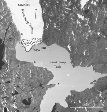
This glacier is a branch off the upper part of Qajuuttap Sermia, that extends about 6 km southwards and ends in the lake of Kuukuluup Tasia (Petersen Reference Petersen1979). Weidick (Reference Weidick1959) referred to this glacier as ‘Nordbogletscher’, while Petersen (Reference Petersen1979) and modern maps use the name Kuukuluup Sermia (= ‘The glacier of the great river’; Fig. 1). The front of the glacier was in contact with the bottom of the lake during its continuous advance from 1953 to 1989 (length profiles are given by Clement (Reference Clement1982: 63), and by Funk (Reference Funk1990: 11).
Recent volume changes of the glacier were determined from analysis of the vertical aerial photographs of 1953, 1977 and 1981 (Knudsen Reference Knudsen1986). Altitudes of the subsurface of the glacier are limited to radar determinations at a restricted number of points (Clement Reference Clement1983b: 21, Fig. 4.3).
Glacier fluctuations have been described by Jenkins (Reference Jenkins1980), Clement (Reference Clement1981), Funk (Reference Funk1990), Warren (Reference Warren1991) and Warren and Glasser (Reference Warren and Glasser1992). In this review supplementary data from publications and archival sources is discussed, although the main emphasis is placed on the information from 1942(?), 1953, 1976, 1981, and 2006.
1940–1949
The July 1942 oblique and vertical aerial photographs show a retracted position of the glacier front (see Fig. 5). The western part of the front is only 50 m from headland C, whereas the eastern parts are some 200 m north of headland E of Fig. 5. While lobate, the trend of the central part of the glacier front runs approximately east-west. The 1942 position is described by Clement (Reference Clement1981: 38–39, Reference Clement1982: 63–64) and Weidick (Reference Weidick1988a: 66). Warren and Glasser (Reference Warren and Glasser1992) have referred this retracted position of the glacier front to a ‘possible Little Ice Age position’.
Frontal part of glacier 1AG05001 (Kuukuluup Sermia), aerial photograph of 28 August 2006 (GEUS-Scankort). Frontal positions are marked for 23 July 1942 (after vertical aerial photographs KMS B34 A-V no. 64), 21 August 1953 (after KMS 201M no. 12581) and 10 August 1981 (after KMS 880B no. 1590).

Oblique aerial photographs from August 1946 shows the glacier front from the east at a distance of approximately 12 km. The position of the front is close to that of 1953 (see below).
1950–1959
Vertical aerial photographs from August 1953 indicate an advance since 1942 of the central parts of the front, that now form an ice promontory in the lake of Kuukuluup Tasia (Fig. 5). The photographs were used for a determination of the frontal change by Clement (Reference Clement1981: 38–39, Reference Clement1982: 63–64), Weidick (Reference Weidick1988a: 66) and Warren and Glasser Reference Warren and Glasser1992: 127). The estimated maximum advance of the glacier front from all sources is between 200 and 300 m for the period 1942–1953.
A photograph of the glacier in 1956 or 1957 from the south was published by Leighty and Poulin (Reference Leighty and Poulin1960: 25, Fig. 37), but is not clear enough for a determination of the frontal position.
1960–1969
A photograph from 1960 (Weidick Reference Weidick1963) and an oblique aerial photograph from June 1963, show the glacier from the south at a distance of approximately 5 km. Both suggest an advance of approximately 100 m since 1953. In 1967 the Brathay Exploration Group (Jenkins Reference Jenkins1980: 20, 29, Fig. 2.11) provided a photograph and a description of the glacier.
1970–1979
A repeat of the 1967 survey was made by the Brathay Exploration Group in 1976. The survey included a mapping of the glacier front 1976 (Jenkins Reference Jenkins1980: 26, Fig. 2.10). Two photographs from 1967 and 1976 show a slight advance during this period. The map of 1976 shows the tip of the ice promontory situated approximately 950 m from headland B in Fig. 5.
In 1977 vertical photographs taken in August (by the Greenland Technical Organisation) were used by Knudsen (Reference Knudsen1986) to map the glacier. The frontal position is given by Clement (Reference Clement1981: 39) and Funk (Reference Funk1990: 9), and indicates the tip of the ice promontory extending to 800–900 m from headland B. The maximum advance of the glacier between 1942 and 1976 is estimated at about 600 m.
In 1977–1978 the maximum velocity of Kuukulup Sermia was determined to be less than 80 m/yr, increasing in 1978–1980 about 100 m/yr, and followed by a gradual decrease to 90 m/y in 1982. These changes have been interpreted as marking the passage of a kinematic wave in Qajuuttap Sermia (Clement Reference Clement1983a: 39–42).
1980–1989
Glaciological investigations were undertaken from 1980 to 1983 (Clement Reference Clement1981, Reference Clement1982, Reference Clement1983a, Reference Clement1984). Vertical aerial photographs provide information for August 1981 and August 1987, and additional investigations were made by Warren and Glasser in 1989 (Warren and Glasser Reference Warren and Glasser1992) and Funk in 1989 and 1990 (Funk Reference Funk1990). Mapping by Knudsen (Reference Knudsen1983, Reference Knudsen1986) of the frontal positions in 1977 and 1981 was included in Funk (Reference Funk1990: 33, 37, Fig. 26, Fig. 29). Clement (Reference Clement1982: 64) describes the fluctuations, as do Warren and Glasser (Reference Warren and Glasser1992) in a sketch map that marks the position of the glacier front in 1981 and from their field observations in 1989.
The aerial photographs of 1987 give a frontal position close to that of 1981 and is also applied by Funk (Reference Funk1990: 10, 26, Fig. 6, Fig. 26); in the years 1989 to 1990 Funk made three inspections of the locality (May–April 1989, August 1989 and August 1990) in order to follow the changes in position of the front. However, there were only small fluctuations of the glacier front in the period. For the decade as a whole a marked decline in the rate of advance of the glacier front is apparent.
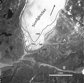
Frontal part of glacier 1AG07008 (Nordgletscher). Aerial photograph of 13 August 2006 (GEUS-Scankort). Frontal positions are shown for 12 August 1946 (route and number unknown), 21 August 1953 (KMS 202 C no.12648) and 10 August 1981 (KMS 880 C, no. 1574)

In respect of the advance of Kuukuluup Sermia, Clement (Reference Clement1982: 64) gives the following dates for maximum advance of the western central ice promontory of the glacier front, taking the position in 1942 as the zero marker – 1953: 360 m, 1977: 625 m and 1981: 665 m. This is a markedly decreasing rate of advance from an average of approximately 33 m/yr in the period 1942–1953 to approximately 10 m/yr in the period 1977–1981.
1990–1999
Investigations from April–May and August 1989, and from August 1990, were reported by Funk (Reference Funk1990). The main aim of this study was to investigate the relationship between water depth in the proglacial lake Kuukuluup Tasia and the amount of calving in the lake. With respect to changes in shape of the Kuukuluup Sermia glacier, it was concluded that between 1952 and 1982 the glacier had been thicker and longer, but that the surface has since been thinning. This thinning (a sinking of the glacier surface) was taken by Funk (Reference Funk1990: 9) to indicate the initiation of a change of glacier behaviour. The profile of the glacier given by Funk shows a glacier with its front resting on the bottom of the lake at approximately 500 m a.s.l., with the lake surface at the front at 660 m asl and the frontal edge at approximately 680 m asl.
2000–2006
The satellite image of 2000 and a vertical aerial photograph from 2006 indicate that the advanced position of the glacier has been maintained (compare Fig. 5).
Nordgletscher (1AG07008)
Nordgletscher is a further northern outlet from the upper part of Qajuuttap Sermia; whereas Kuukulup Sermia branched off at an altitude of 900–1000 m asl, Nordgletscher split off from Qajuuttap Sermia at a slightly higher altitude of 1100–1200 m asl (Fig. 1). Nordgletscher is about 9 km long and terminates on land.
The earliest information on the glacier comes from the oblique aerial photographs of 1942. The first descriptions of the glacier seem to have been made by Frost (Reference Frost1957) and Leighty and Poulin (Reference Leighty and Poulin1960), in connection with investigations for an access route from Narsarsuaq air base to the ice sheet margin. The description of Leighty and Paulin (Reference Leighty and Poulin1960: 29) concerns the front of Nordgletscher. They report that from aerial photographs there are indications that the frontal area ‘was inundated by a rather large lake at one time, and the soils now contain an appreciable amount of silt’, and further that: ‘[a] point of academic interest in this area is the movement of the glacier near the river crossing. In the photos of August 1956 the furthest point of advance is some 600 to 700 ft less than in June 1957’.
Volume changes of the glacier were determined on the basis of vertical aerial photographs from 1953 and 1981 (Knudsen Reference Knudsen1986). As was the case for Kuukulup Sermia, a volume increase for Nordgletscher was especially marked in the frontal area.
1940–1949
This period is covered by oblique aerial photographs from 1942 a vertical photograph from 1946 and oblique photographs from 1947; a link with changes in the next decade is provided by vertical aerial photographs from 1953.
It was concluded that a minor advance took place in the period 1942–1946, and that it amounted to 50–100 m (compare the data collected by Clement (Reference Clement1982: 64), referred to in the discussion of the decade 1980–1989 below). However, the vertical aerial photograph from 1946 shows that the advance from 1946 to 1953 was not 50–150 m as estimated from the sketch map of Weidick (Reference Weidick1963: 23) and used by Clement, but rather some 350 m as shown by a comparison of the two vertical photographs of 1946 and 1953 (positions shown here in Fig. 6).
1950–1959
Information provided by the Geodetic Institute map sheet (Geodetic Institute 1968) is based on oblique aerial photographs flown in 1962–1963 over the Nordgletscher. The map shows the glacier approximately 200 m north of the river bed A (Fig. 6), that is to say somewhere between the positions for 1946 and 1953 shown in Fig. 6.
A more detailed map at 1: 20000 with 10 m contour intervals was prepared by Knudsen (Reference Knudsen1986), based on 1953 vertical aerial photographs, for comparison with the volume change in 1977 and 1981.
The engineering report of Leighty and Paulin (Reference Leighty and Poulin1960), mentioned above, indicates the advance of the glacier from August 1956 to June 1957 to be 600–700 ft (183–214 m), corresponding to an annual advance of 200–230 m/yr. However, compared to other information for the period this seems excessive.
1960–1969
Information includes a short description of a visit to the glacier in 1960 given by Weidick (Reference Weidick1963, Reference Weidick1988a), supplemented by a mapping of the front in 1969 by Metcalfe (Reference Metcalfe1969: 8, 27–28; see also Jenkins Reference Jenkins1980: 31, Fig. 2.13). In their reports earlier measurements for the period 1947–1969 are recorded.
1970–1979
During this decade mapping of the glacier front was undertaken by the Brathay Exploration Group in 1972 and 1976 (map in Jenkins Reference Jenkins1980: 31, and Metcalfe Reference Metcalfe1969: 28). Forward movement between 1972 and 1976 was fairly rapid, and the ice front advanced 100 m in only four years.
Aerial photographs of the front were flown for the Greenland Technical Organisation in 1977 (Knudsen Reference Knudsen1986). For the period 1947 to 1980, the frontal fluctuations are collated by Jenkins (Reference Jenkins1980: 29–30 and map) and Clement (Reference Clement1982: 64, see below).
1980–1989
The position of the glacier front in 1980 was measured by Clement (Reference Clement1981: 41), who also collated available information for the period 1946–1981 (Clement Reference Clement1982: 64). In summary, he records the total frontal position advance using the aerial photograph of 1947 as the zero mark – 1953: 50 m, 1960: 155 m, 1969: 175 m, 1972: 282 m, 1976: 382 m, 1980: 553 m and 1981: 597 m. The values are applied, but corrected with 350 m in Table 4 (see Appendix).
Vertical aerial photographs from 1981 were studied by Clement (Reference Clement1981) and Knudsen (Reference Knudsen1986). At the end of the decade a survey of the frontal position was made by Warren and Glasser (Reference Warren and Glasser1992). Total advance of the front for the period 1953–1981 is approximately 550 m, as shown by the delineation of the fronts in Fig. 6
1990–1999
No photographic or survey information is available for this decade, but based on earlier and later observations the total advance is estimated at approximately 100 m.
2000–2006
This period is documented by a satellite image from 2000, and vertical aerial photographs from 2006. These demonstrate that the rate of advance culminated in the 1980s, and development of a narrow trim line zone at the lower margins of the glacier in 2006 indicate that the glacier has stopped advancing and may have begun to retreat.
The information for the period 1980–2006 is essentially limited to aerial photographs and satellite images, but interpretations can vary somewhat. While Warren and Glasser (Reference Warren and Glasser1992: 129) suggested an advance of approximately 750 m for the period 1953–1981, the compilation of Fig. 6 indicates an advance of approximately 550 m for the same period. However, a culmination of the advance in the 1980s seems clear, with the rate of advance slowing down during the 1990s. During the first years of the new millennium the glacier began to stagnate, and now shows the first signs of recession.
Discussion and conclusions
Although this article essentially comprises an historical description of glacier changes around Johan Dahl Land, and notably of the Qajuuttap Sermia glacial system, a short review of the Holocene is relevant prior to discussion of the historical fluctuations.
Holocene history of the area
Recession of the Wisconsinan ice cover after some 21 ka BP resulted in a deglaciation of the inner parts of the Tunulliarfik fjord system as early as 9.7 ka BP (Weidick and others Reference Weidick, Kelly and Bennike2004). In Sermilik ice fjord datings of Holocene deposits are only available from the Tasiusaq area, some 25 km south of the front of Qajuuttap Sermia; deglaciation may have taken place here as early as 11 ka BP (Sparrenbom and others Reference Sparrenbom, Bennike, Björck and Lambech2006). Both these dates are earlier than those for other areas of west Greenland, where the present position of the ice cover during the early Holocene recession first was reached at about 8 ka BP.
A subsequent readvance, resulting in the deposition of the well defined and characteristic ice margin deposits of the Narssarssuaq stade took place in the early neoglacial (Weidick Reference Weidick1963). A more exact age for this deposition was determined from pollen investigations in a lake (‘Cedar Lake’) near Narsarsuaq air base. This lake is surrounded by moraines of the Narssarssuaq stade, presumably formed shortly before 2000 years ago (Bennike and Sparrenbom Reference Bennike and Sparrenbom2007).
The geographical extension of the stade into the Johan Dahl Land area where the outlets Qajuuttap Sermia, Kuukuluup Sermia and Nordgletscher are located is uncertain. The description of the Qajuuttap Sermia glacier front in 1894 may indicate that a westward extension of the ice margin features of the Narssarssuaq stade had occurred, but any such ice margin deposits have been buried by the present expansion of the ice margin. This may also account for the expansion of the Qajuuttap glacier system after AD 1894 and 1932, but before 1942(?). The small amount of sediment at the present outlet of Kuukuluup Sermia in the lake of Kuukuluup Tasia may indicate a recent formation of this glacier. The present expansion of Qajuuttap Sermia may then have led to an ‘overspill’ of the southern margin of Qajuuttap Sermia, resulting in the formation of Kuukuluup Sermia, as the lake Kuukuluup Tasia drains via the river Kuukulooq into Tunulliarfik Fjord.
The bottom conditions of the lake Kuukuluup Tasia (Larsen Reference Larsen1981) and radar soundings of the Kuukuluup Sermia and Qajuuttap Sermia glaciers (Clement Reference Clement1983b) seem to indicate the presence of a corrie down to a depth of 400 m asl incised into the upland beneath the upper parts of Qajuuttap Sermia, where elevation of the glacier bed of 600–800 m asl have been recorded. There seems to be a threshold beneath Qajuuttap Sermia where Kuukuluup Sermia splits off, as suggested by the trend of the 900 m contour line of the glacier surface on the 1:250,000 topographic Geodetic Institute map sheet (Geodetic Institute 1968). Beneath the main glacier of Qajuuttap Sermia, a typical U shaped valley seems first to have been developed at altitudes below the 800 m contour line, but no soundings have been made here.
The early neoglacial expansion (the Narssarssuaq stade) approximately 2000 years ago may be related to a relatively cold (and humid?) spell preceding the Mediaeval warm period (in the first millennium AD), whereas the present expansion may be related to the Little Ice Age (about AD 1500 to the last half of the 1800´s). It is also possible that the prehistoric fluctuation do not essentially express temperature changes, but like the historic ‘Qajuuttap Sermia advance’ discussed here may rather reflect variations in distribution of the precipitation on the western and eastern sides of the present ice divide on the southern slopes of the inland ice margin, a process that may also influence the situation of the ice divide itself.
Recent history of glacier advance (‘The Qajuuttap Sermia advance’)
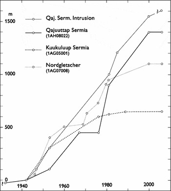
For the three glacier lobes of Qajuuttap Sermia, Kuukuluup Sermia and Nordgletscher, the development of the most recent advance, in spite of many uncertainties, estimates and discrepancies in the material, can be divided into three phases of development as shown in Fig. 7, and could therefore be labelled ‘the Qajuuttap Sermia advance’.
Estimated positions of the glacier fronts in the Qajuuttap Sermia glacier system. This includes Qajuuttap Sermia, frontal height 0 m asl; Kuukuluup Sermia, frontal height (lake level) 660 m asl and Nordgletscher, frontal height; 650 m asl). The intrusion of a tributary lobe of Qajuuttap Sermia into the glacier 1AH08002 (height of lowermost part approximately 100 m asl) is shown as ‘Qaj. Serm. Intrusion’. The curves indicate rates of advance throughout the period of 1932–2006.

1) An initial advance phase.
Rate of advance about 10 m/yr or less. Date of initiation unknown. For all glaciers, the period may have ended at or before the 1940 s.
2) Culmination of the advance.
A period for which the average rate of advance increased to maximum values of about 24 m/yr (Qajuuttap Sermia 1942–2000), 17 m/yr (Kuukuluup Sermia 1942–1981) and 24 m/yr (Nordgletscher 1942–1981).
3) Deceleration and cessation of advance.
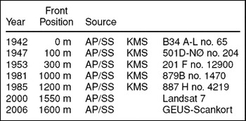
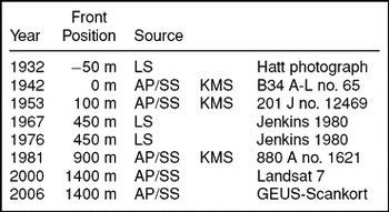
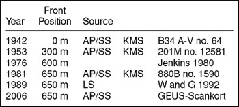
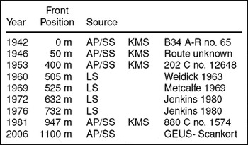
Abbreviations for all tables:
AP/SS: Applied aerial photographs or satellite scenes.
LS: Literary sources.
KMS: Kort og Matrikelstyrelsen (National Survey and Cadastre, incorporating the former Geodetic Institute, Copenhagen).
GEUS: National Geological Survey of Denmark and Greenland.
This seems to have been reached shortly before 2000 for Qajuuttap Sermia, somewhat earlier, around 1980, for Kuukuluup Sermia, and shortly before 2000 for Nordgletscher. With respect to the calving glaciers of Qajuuttap Sermia and Kuukuluup Sermia, there can scarcely be any doubt that their present locations at the widening of the fjord or lake systems have strongly influenced the present stand still of the front. However, the thinning (lowering of the glacier surface height) of Kuukuluup Sermia from 1982–1989 as indicated by Funk (Reference Funk1990: 9), and the development of a narrow trim line zone around the lowermost parts of Nordgletscher, may be interpreted as an initial recession of these glaciers.
The scattered data of the Tables 1 to 4 in the appendix forms the basis for the frontal positions of the glaciers shown in Fig. 7. They were mainly determined during the summer months. Measurement to specific points of the glacier fronts and occasional calving of large parts of a front can easily veil the general trends. Thus, the apparent stand still of the central parts of the front of Qajuuttap Sermia from 1967–1976 could be due to an pronounced calving event just prior to 1976; the Brathay Expedition (Jenkins Reference Jenkins1980) observed glacier ice remnants extending up to 230 and 630 m out on the mountain sides in front of Qajuuttap Sermia.
Advance of Qajuuttap Sermia into tributary lAH08002.

Qajuuttap Sermia. Advance of central part of front.

Kuukuluup Sermia. Advance of central parts of front.

Note: W and G 1992 is Warren and Glasser Reference Warren and Glasser1992.
Nordgletcher. Advance of central parts of front.

Note: The entries for 1953, 1960, 1969, 1972, 1976, and 1981 are corrected.
Even if the curves of Fig. 7 are only taken to provide a general impression of the changes of the glacier fronts, the initiation of the glacier advance may be dated to, at, or before 1940, culminating in the period 1945–1980, and followed by the present period of stagnation or initial recession. The intrusion of Qajuuttap Sermia into the valley of tributary 1AH08002 seems to have continued to the present day, and this continued advance can be taken as an expression of the continued thinning of the neighbouring glaciers of 1AH08002, 1AH08007 and 1AH08016.
Causes of the advance of the Qajuuttap Sermia glacier system
South Greenland is in a glaciological sense remarkable for its rapid deglaciation after the Wisconsinan glaciation; the ice margin in South Greenland had already reached its present extension by around 11 ka BP. However, the subsequent development around Narsarsuaq in Johan Dahl Land in the inner parts of south Greenland appears to differ from the normal scenario with the culmination of the large neoglacial readvance at some 2 ka BP (the Narssarssuaq stade), that extended beyond the following general advances during the Little Ice Age such as the minor Qajuuttap Sermia advance in the last half of the 20th century.
The early and rapid response of the south Greenland ice cover during the early Holocene is related to the relatively warm and humid conditions in this part of Greenland, implying a fast ‘turn over’ of the mass balance compared to conditions farther north in Greenland. But this does not explain the subsequent neoglacial advances such as the Narssarssuaq stade or the following minor advance of the Qajuuttaq Sermia glacier system.
This behaviour may be linked to the local mass balance conditions of the ice cover in south Greenland. The precipitation on this sector of the inland ice is relatively high. The solid accumulation over the catchment area of Qajuuttap Sermia glacier system has here been estimated at 80–90 cm water equivalent according to the map of Ohmura and Reeh (Reference Ohmura and Reeh1991). However, only 20–50 km farther to east (the eastern slope of the ice sheet) an increase to 150 cm water equivalent is shown on this map. The large spatial variation over a relatively small area implies that small changes in the distribution pattern of the accumulation may result in large variations in the mass balance and the response of the outlet glaciers of the different segments of the ice cover of south Greenland. Such changes in the distribution of precipitation were noted by Georgi as early as 1933 (Georgi Reference Georgi1933).
That accumulation in this upland region of the inland ice margin may be susceptible to local strong variations in precipitation, may arise because this is the first elevated region encountered by all low pressure systems heading northeastwards towards Greenland. This upland region of the ice sheet margin may be pivotal in driving low pressure systems either northwards along the coast of west Greenland, or northeastwards along the coast of east Greenland, resulting in large periodic variations in accumulation patterns on the ice sheet.
Unfortunately, meteorological measurements in the region are restricted to data from Narsarsuaq air field, that only extend back to 1941 (Grønlandsdepartementet 1952), and glaciological mass balance measurements on and around Kuukuluup Sermia covering the years 1977–1983, as mentioned above. Later glaciological investigations were made at the inland ice margin approximately 70 km southwest of the front of Qajuuttap Sermia (Podlech Reference Podlech2004). On the inland ice, ice coring has only been carried out at the Dye 3 station some 450 km north of the front of Qajuuttap Sermia. Information on local long term variations of temperature and precipitation from the region of the accumulation area of Qajuuttap Sermia is still lacking.
Acknowledgements
Andreas Almgreen, Hans Jepsen and Margareta Christoffersen have provided material for updating the glacier fluctuations. Henrik Klinge Pedersen, Eva Melskens and Benny Schark have helped in the preparation of the illustrations. The help and advice received from Andreas Almgreen, Ole Bennike, Naja Mikkelsen, Robert Fausto, Jens K, Kleist, Henrik H. Thomsen and W. Stuart Watt is gratefully acknowledged. The manuscript has benefited from a careful review and English improvements by A.K. (Tony) Higgins. Thanks also go to Rene Aussenthal (KMS) for help with localising and dating of aerial photographs in the KMS collections and to the two anonymous referees for their comments and proposals.