Freshwater procurement is a constant of social life: success or failure is a matter of concern for every community and individual. Since restricted access to water inflicts hardship on individuals and communities, water management has triggered inventive technologies and been an important catalyst for social cooperation, competition, and conflict throughout the human past. Supplying clean freshwater justly remains a central issue in current global development discourse (United Nations Development Programme 2006).
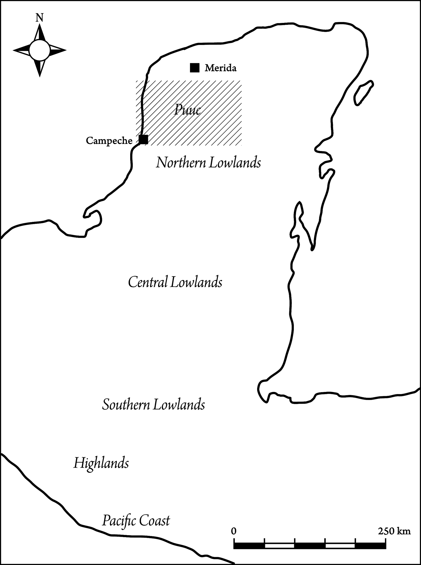
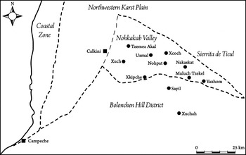
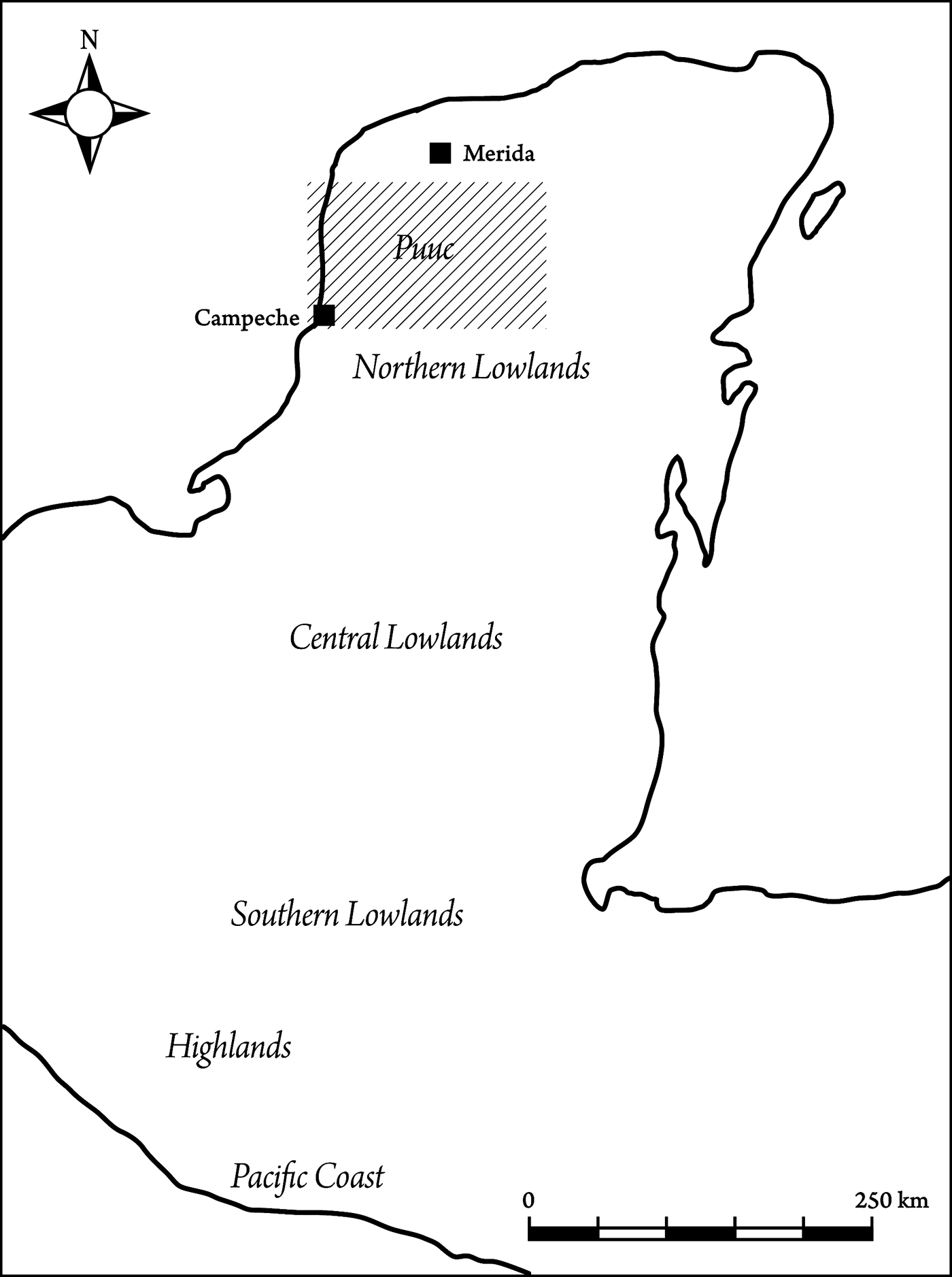
In the pre-Hispanic Maya lowlands (Figure 1), archaeological research demonstrates that water management—involving a number of different aspects (technical, economic, political, symbolic, etc.)—was multi-componential, diverse across space, and shifted over time (Adams Reference Adams1980; Ashmore Reference Ashmore1984; Brown Reference Brown, Lucero and Fash2006; Davis-Salazar Reference Davis-Salazar2001, Reference Davis-Salazar2003, Reference Davis-Salazar2006; Dunning Reference Dunning and Grube1995, Reference Dunning, Breton, Becquelin and Ruz2003; Dunning et al. Reference Dunning, Beach, Luzzadder-Beach, Lucero and Fash2006; Fash Reference Fash, Andrews and Fash2005; Fash and Davis-Salazar Reference Fash, Davis-Salazar, Lucero and Fash2006; Fedick et al. Reference Fedick, Morrison, Andersen, Boucher, Ceja-Acosta and Mathews2000; French et al. Reference French, Stuart, Morales, Lucero and Fash2006; Johnston Reference Johnston2004; Kunen Reference Kunen, Lucero and Fash2006; Lucero Reference Lucero2002, Reference Lucero2006a, Reference Lucero, Lucero and Fash2006b; Lucero and Fash Reference Lucero and Fash2006; Matheny Reference Matheny1976, Reference Matheny, Harrison and Turner1978; McAnany Reference McAnany, Culbert and Rice1990; Pope and Dahlin Reference Pope and Dahlin1989; Puleston Reference Puleston and Hammond1977; Pyburn Reference Pyburn2003; Scarborough Reference Scarborough, Scarborough and Isaac1993, Reference Scarborough1994, Reference Scarborough and Fedick1996, Reference Scarborough1998, Reference Scarborough2003, Reference Scarborough, Lucero and Fash2006; Scarborough and Isaac Reference Scarborough and Isaac1993; Siemens Reference Siemens, Harrison and Turner1978). In the Puuc region of the northwestern Yucatan Peninsula (Figure 2)—a seasonally dry region with no permanent natural water sources—two hydro-technological inventions designed to capture and store rainwater dominated water management during the Late Classic to Early Postclassic periods (a.d. 600–1250): large, open still-water reservoirs (aguadas) and small underground water cisterns (chultunob). Water cisterns were typically constructed in the center of each residential architectural group and seem to have formed the main source of freshwater for domestic use in each household (McAnany Reference McAnany, Culbert and Rice1990; Zapata Peraza Reference Zapata Peraza1989). Water reservoirs with the potential to store greater volumes are quite widespread in the Puuc region. Dunning (Reference Dunning2008) records 38 such aguadas of shifting sizes in the Puuc region, but the real number of pre-Hispanic Puuc water reservoirs is probably higher. The role of open-water reservoirs in Puuc water management practices has not been addressed in previous research, but in analogy with the place of water reservoirs in the political economy of Classic period Maya centers further south, for instance at Tikal (Scarborough Reference Scarborough1998), they seem to have been managed at a higher level of social organization. This contribution discusses some of the economic, political, and symbolic significance of large rainwater reservoirs in the physical transformation and social construction of the Puuc, particularly drawing on recent archaeological investigations at Xuch, a Late Classic to Early Postclassic mid-tier settlement in Campeche, Mexico (Isendahl Reference Isendahl2002, Reference Isendahl2006a). The evidence at Xuch suggests that the roles of Puuc reservoirs were similar to large open-water reservoirs elsewhere in the Maya lowlands, as recently discussed by Scarborough (Reference Scarborough1998), among others.
The main Maya regions of southern Mesoamerica. The box indicates the more detailed map of the Puuc region seen in Figure 2. Map by the author.
The Puuc sub-region. The physiographic districts of the northwest Yucatan Peninsula described by Dunning (Reference Dunning1992:21–22) are shown in italics. The Nohkakab Valley (also known as the Santa Elena District) is the core zone of the Puuc, which also extends southwards into the Bolonchen Hill District and northwards to the slopes of Sierrita de Ticul at the boundary to the Northern Karst Plain. Points mark the locations of the central civic-ceremonial complexes of pre-Hispanic Puuc settlements mentioned in the text. Contemporary towns are indicated by squares. Map by the author.

A seasonally dry climate, a lack of permanent streams and water bodies, and ground water levels that were too deep to access using pre-Hispanic technology contributed to make the capture and storage of rainwater a central sustenance issue in the Puuc region. Large open still-water reservoirs were fashioned from relatively shallow depressions that occur naturally in flatland areas in the region's mosaic topography. The Classic period Maya modified these natural depressions to increase rainwater capture, volumetric storage capacity, and to control seepage. Depressions can only develop where there are relatively deep deposits of Quaternary soils overlying fractured sections of the Cretaceous and Tertiary limestone bedrock structure, and their distribution in the region is both restricted and irregular (Dunning Reference Dunning1992, Reference Dunning2008). Depressions that could be converted into large water reservoirs were resources of potentially great economic value and key attractors of settlement in the landscape. Water reservoirs seem to have been important components of Classic period Puuc Maya agro-urban settlement models.
As elsewhere in the Maya lowlands (Scarborough Reference Scarborough1998), Puuc water reservoirs were not only a matter of economy and sustenance. In Maya world-view, water and Earth-penetrating cavities had strong symbolic significance. Puuc reservoirs seem to have related to cosmological symbolism in very many different ways. For instance, depression formation is associated with hydrological swallow-holes in the bedrock, cavities in the geological structure through which water and soil drained during the rainy season. Archaeological, iconographic, epigraphic, and ethnohistoric evidence indicate that such geomorphological features were perceived as symbolic representations of axis mundi, horizontal centers of creation and conduits connecting the different vertical levels of the cosmos (Bassie-Sweet Reference Bassie-Sweet1996; Brady Reference Brady1997; Brady and Prufer Reference Brady and Prufer2005; Eliade Reference Eliade1959a, Reference Eliade1959b; French et al. Reference French, Stuart, Morales, Lucero and Fash2006; Prufer and Brady Reference Prufer and Brady2005). Combined, the powerful symbolism of bodies of water and of cavities in the earth made water reservoirs some of the most important places in Classic period Puuc sacred landscapes.
Another aspect of cosmological conceptualization of environment discussed briefly in this paper is the idea of an animate Earth that seems to have been alive in Maya cosmology (e.g., Brown and Walker Reference Brown and Walker2008). In the karst limestone landscape of the Puuc region, the long-term natural and anthropogenic formation processes of reservoirs periodically involved spectacular workings of the elements. Pulses of earth, wind, and water in motion acting to shape and reshape the karst landscape seem to have contributed to a conceptualization of Earth as animate, a living organism. Furthermore, perceptions of fluids flowing, entering cavities, and—after a long and complex gestation period—giving birth to an essential resource might have linked metaphors of sexuality closely with agricultural fertility of the landscape and political prowess of the governing elite. Although water reservoirs were probably utilized in a number of different functional ways—for instance in pot irrigation of infields and in domestic consumption by privileged households—their significance might also have rested in their capacity as symbols of political potency.
Large-scale public events were key political tools in the integration and identity formation of Maya communities and in legitimizing elite authority, and ensuring ceremonial spaces for such ceremonies was therefore of major concern in Maya agro-urban settlement planning. In addition to clearly planned and built ceremonial spaces, such as plazas (Inomata Reference Inomata2006) and ballcourts (Fox Reference Fox1996), located within the central civic-ceremonial core complexes of many Maya agro-urban landscapes, large water reservoirs—in some cases—seem to have been some of the most important places for integrating political ritual (Lucero Reference Lucero2006a; Scarborough Reference Scarborough1998).
For half a century archaeologists have addressed the idea that water management played a crucial role in the development of complex societies (Wittfogel Reference Wittfogel1957; see also Scarborough Reference Scarborough2003 for a comprehensive updated overview of the development and main issues in this field of research). Over the last few years a handful of scholars have covered several different critical aspects of Classic period water management in the Maya lowlands, including water symbolism in ideology and cosmology, political and religious ritual associated with water sources, and the political control of a key economic resource (Davis-Salazar Reference Davis-Salazar2001, Reference Davis-Salazar2003, Reference Davis-Salazar2006; Lucero Reference Lucero2002, Reference Lucero2006a, Reference Lucero, Lucero and Fash2006b; Lucero and Fash Reference Lucero and Fash2006; Scarborough Reference Scarborough, Scarborough and Isaac1993, Reference Scarborough1994, Reference Scarborough and Fedick1996, Reference Scarborough1998, Reference Scarborough2003, Reference Scarborough, Lucero and Fash2006; Scarborough and Isaac Reference Scarborough and Isaac1993). Their groundbreaking work has opened up the field of water management in the Maya lowlands, addressing patterns of similarity and variation in management histories. This work—and Scarborough's (Reference Scarborough1998) seminal paper can be singled out here—demonstrates a very strong link between water symbolism in Maya cosmology, water as an economic resource, the control of water as a basis for political power, and water sources as the loci for political ritual.
Most current research on Maya water management draws on field data from the central and southern lowlands of today's Guatemala, Belize, and Honduras. The environment and culture history of the Maya lowlands however is diverse and little recent work has focused on water management in the northern peninsula, which—owing to lower annual precipitation levels than further south—is even more prone to water shortages and crises. The evidence now surfacing from the Puuc region offers some clues on the economic, political, and symbolic importance of still-water reservoirs in this region. The evidence reported here (in particular the central location of the reservoir in the agro-urban landscape, its association with the civic-ceremonial core complex, the high amount of energy invested in reservoir construction and maintenance, and the volumetric storage capacity of the reservoir) supports the interpretations of water reservoirs as key economic, political, and symbolic features in Classic period Maya landscapes.
INVESTIGATING THE XUCH LANDSCAPE
Xuch is a complex cultural landscape with large expanses of archaeological remains. It is located in the heartland of the Puuc region in northern Campeche, Mexico, around central settlement precincts located roughly at 20o19'10'' northern latitude and 89o56'20'' western longitude. In Yucatec Maya, xuch has a number of connotations related to water and to the flow of substances (Barrera Vásquez Reference Barrera Vásquez1995:953–954). Xuch can signify containers or bodies of water—for instance cisterns or reservoirs—but may also specifically refer to the drains of such features. It sometimes refers to a mouthful of water and as a verb it means to engulf, devour, or inhale liquids and substances through the mouth or nose. As a toponym of the research area, Xuch specifically refers to a hydrological phenomenon known as a swallow-hole: a vertical channel in the geological structure that has formed through limestone solution and which connects the surface with the aquifer. At Xuch, the swallow-hole is found in the bottom of a dry aguada, the remains of a large pre-Hispanic water reservoir in the midst of the archaeological landscape.
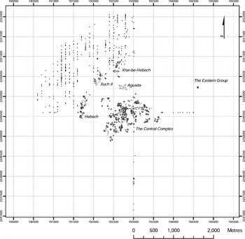
Reported almost 30 years ago (Garza Tarazona de Gonzalez and Kurjack Basco Reference Garza Tarazona de Gonzalez and Basco1980:103), more recent investigations—including architectural, ceramic, geochemical, environmental, and ethnoecological inquiry (Isendahl Reference Isendahl2002, Reference Isendahl2006a; Williams-Beck and Okoshi Harada Reference Williams-Beck and Harada1998)—demonstrate that Xuch is largely similar to other better known Puuc settlements, for instance Sayil (Sabloff and Tourtellot Reference Sabloff and Tourtellot1991) and Xkipche (Prem Reference Prem2003), and follows an agro-urban landscape model of Late Classic to Early Postclassic period Puuc Maya low-density settlement systems that interdigitates urban with rural land uses (Isendahl Reference Isendahl2002; see also Fletcher Reference Fletcher and Smith2009; Stark and Ossa Reference Stark and Ossa2007). A civic-ceremonial nodal core complex partly linked together by an east-west trending system of causeways, large sectors of dispersed residential settlement remains, open spaces interpreted as pre-Hispanic cultivated fields, and the central water reservoir are key elements of the archaeological landscape at Xuch, which covers at least 20 km2 (Figure 3).
Surface architecture documented at Xuch. Five settlement clusters were mapped during the 1998 field season at Xuch: The Central Complex, Hebech, Xuch II, Xhai-be-Hebech, and the isolated Eastern Group. The points on the map represent surface architecture located and described during systematic transect survey in the northwestern section (see Isendahl Reference Isendahl2002). Note the central location of the aguada in relation to the settlement remains.

Xuch is located in the heartland of the Puuc, a region that until recently has been known physiographically as the Santa Elena District, named after a colonial town located in the center of the region (Dunning Reference Dunning1992:16). Dunning (Reference Dunning2008) recently proposed the alternative term Nohkakab Valley, a name instead based on the pre-Hispanic Yucatec Maya toponym for Santa Elena. Nohkakab means “the place of good earth” (Dunning Reference Dunning2008) and is quite an appropriate denomination for an area with soils considered among the most fertile on the northern Yucatan Peninsula. In this text I adopt this new term. The Nohkakab Valley is a wedge-shaped zone of very gently folded, bedded limestone covering some 1,300 km2 defined on the north and east by the Sierrita de Ticul, a northwest-southeast trending ridge system, and to the south by the northern fault escarpment of the Bolonchen Hills, a zone dominated by cone karst formations (Dunning Reference Dunning1992:16). Xuch is located in the western section of the Nohkakab Valley where the rolling topography is interspersed with relatively low-lying areas showing little difference in micro-relief, producing a local mosaic landscape at Xuch of low hills, valleys, and flatlands at an altitude between 30 and 50 m (Isendahl Reference Isendahl2002:54–55). The local soilscape is diverse and generally productive and sufficient access to water is the principle limiting factor for agriculture in the region. In the karst hydro-system, surface water rapidly penetrates the permeable fractured limestone, preventing permanent streams from developing (Dunning Reference Dunning1992; Isendahl Reference Isendahl2002; Tamayo and West Reference Tamayo, West and West1964; Wilson Reference Wilson, Mosely and Terry1980). But karst landforms (sinkholes, wells, and caves) shaped by limestone solution are important sources of water in many areas of the Yucatan Peninsula. Round sinkholes (cenotes) are common in the low-lying coastal karst plains to the north, but are not to be found in the Puuc. The pre-Hispanic Puuc Maya did not construct very deep wells and at Xuch—where the aquifer were located at depths of at least 25 m (data from Comisión Nacional del Agua [CNA], Campeche)—the water table was not an accessible resource. There are only three known caves accessing the water table in the Puuc, among them the cave system at Xcoch in the eastern Nohkakab Valley that intersects the aquifer at a depth of 65 m (Dunning Reference Dunning1992, Reference Dunning2008; Smyth and Ortegón Zapata Reference Smyth and Zapata2008). Usually in the Puuc region, however, underground water cisterns were the most important water storage devices at the level of the household. These were constructed by puncturing the calcite caprock of the limestone and excavating an underground chamber in the underlying layer of soft dolomite (sascab), typically near the center of each household group. The area surrounding the cistern orifice was kept clean to facilitate capture of rainwater and cistern walls were plastered to prevent seepage in the permeable sascab (Matheny Reference Matheny, Harrison and Turner1978; Zapata Peraza Reference Zapata Peraza1989). At Xuch, 238 cisterns have been registered (Isendahl Reference Isendahl2002), but the available data is insufficient to calculate volume averages. Estimations elsewhere suggest considerable variation in storage capacity of Puuc water cisterns, between 7,000 and 95,000 liters (McAnany Reference McAnany, Culbert and Rice1990:268).
The ability to store water was crucial to sustain sedentary Puuc agro-urban communities. The climate is sub-humid but seasonally dry: more than 80% of the annual precipitation average of 1,145 mm falls in the six wettest months (data from CNA, Merida). June to September comprise the summer rainy season, with mean precipitation levels peaking in September. The annual climatic pattern is principally controlled by the seasonal movements of the Azores High subtropical anticyclone (AH) and the intertropical convergence (ITC) (Wendland and Bryson Reference Wendland and Bryson1981). The wet season is associated with the interaction of the westward movement of air masses of the AH and the northward expansion of the ITC, which starts in late meteorological spring. During the first half of the rainy season there is often a summer dry spell (the canícula), caused by oscillations in the northward extension of the ITC. The precipitation peak in September is related to the hurricane season. Although relatively localized and infrequent (one hurricane crosses the Yucatan Peninsula on average a year [Wilson Reference Wilson, Mosely and Terry1980:23]), these must have had potentially devastating effects in the past, as they often do in the present. For instance, bringing 200 mm of rainfall to Calkini on September 14, 1988 (data from CNA, Campeche), Hurricane Gilbert is estimated to have destroyed 90% of the maize crop across the Yucatan Peninsula (Dunning Reference Dunning1992:25). The dry season begins as the ITC and the subtropical westerly jet stream move south and hurricanes and tropical storms cease to form over the warm waters of the mid-Atlantic and the Caribbean (Hastenrath Reference Hastenrath1966). Dry season rainfall is caused by sporadic southward invasions of polar air (nortes) that pick up moisture from the Gulf and produces rain when passing over the peninsula (Bryson and Hare Reference Bryson, Hare, Bryson and Hare1974:13; Mosiño Aleman and García Reference Mosiño Aleman, García, Bryson and Hare1974:357; Vivó Escoto Reference Vívo Escoto and West1964:193; Wilson Reference Wilson, Mosely and Terry1980:23).
The annual climatic pattern include several crucial periods that present potential challenges to living and cultivating in the Puuc: (1) the timing of the wet season in late spring/early summer; (2) the length, stability, and net precipitation of the wet season; (3) the timing and severity of the canícula, the summer dry spell; (4) the potential damage of hurricanes and tropical storms in late summer/early autumn; and, (5) the distribution and volume of dry season rains in the period from late autumn to early spring. In addition to storage and dry season buffering, an important aspect of agricultural water management in the Puuc region involves capturing and storing rainwater for pot irrigation during the summer dry spell. The start of the planting season is coordinated with the beginning of the wet season in late spring/early summer. Then, at the heel of the planting season when the tender plants are the most delicate, the canícula might set in. If the young plants do not receive sufficient moisture they will perish in the high-summer heat and the fields will have to be replanted—late in the season—with less optimal climatic conditions and a great risk of a poor or failed harvest. Effectively managing water, crops, and fields through the canícula was among the most crucial activities of the Puuc agricultural calendar to sustain a productive agrosystem. Although modern irrigation minimizes some of the vulnerability to climate anomalies of rain-fed agriculture in the Puuc environment, sufficient moisture availability for plant growth is still cause for concern among farming households practicing low-technological forms of swidden agriculture (milpa farming) and climatic and hydrological characteristics forestall permanent settlement. “It is a place for work, not to live,” say the elderly farmers now cultivating the soils at Xuch. Commuting 15 km from Calkini, they bring in plastic containers of drinking water by truck for work-intensive periods of clearing at the end of the dry season. This picture of farming must be contrasted with that of the Late Classic to the Early Postclassic periods when the Puuc formed a complex, intensely cultivated cultural landscape with numerous large sedentary settlements. A handful of paleoclimatic proxy sources from throughout the northern Yucatan Peninsula (e.g., Brenner et al. Reference Brenner, Rosenmeier, Hodell and Curtis2002) suggest generally drier conditions than today and indicate several drought episodes during the later period of Puuc agro-urban settlement. Indeed, Dunning (Reference Dunning2008) argues that the investment in reservoir construction in the Puuc region may possibly have been in response to increasingly arid conditions in the Terminal Preclassic and again in the Terminal Classic period. Either way, managing a crucial resource that was periodically in short and erratic supply was a key to household and community survival in the Puuc region.
FORMATION PROCESSES OF THE XUCH WATER RESERVOIR
Although aguadas are quite widespread in the Nohkakab Valley their total number and distribution in the Puuc is still inadequately known. Dunning (Reference Dunning2008) lists 38 known aguadas, but the inventory is likely to expand—perhaps significantly so—with further field surveys. Thirteen of those known from the Puuc are found at Uxmal, five at Tzemez Akal, four at Xcoch, two at Nohpat, and there are 14 pre-Hispanic settlements with a single water reservoir, Xuch among them. As Nicholas Dunning (personal communication 2009) points out, Puuc aguadas come in many sizes and shapes, but there is no direct correlation between settlement size and reservoir size.
The formation of Puuc water reservoirs is a complex long-term process that has involved both natural forces and human engineering (Dunning Reference Dunning2008). Reservoirs were fashioned from topographic depressions located in the flatlands of the Puuc landscape mosaic. These flatlands are composed of Quaternary soil deposits that are known as Kancab in the local folk soil taxonomy, a dominating feature of the Nohkakab soilscape (Dunning Reference Dunning1992). Kancab soils are equivalent to Nitisols in the Food and Agriculture Organization of the United Nations (FAO) soil taxonomy and to Alfisols in the United States Department of Agriculture (USDA) system of classification. These are deep, well-drained, and permeable red to reddish brown clayey soils that are generally regarded among the most productive in the tropics (Driessen et al. Reference Driessen, Deckers, Spaargaren and Nachtergaele2001). In the western part of the Nohkakab zone they are found in pockets of variable acreages, from a few hectares to several square kilometers. Depressions—or shallow hollows in the terrain—may form naturally in these flatlands when structural fracturing is occurring in the limestone bedrock underlying the soil cover (Dunning Reference Dunning1992:22). In the karst geomorphology of the Puuc region, large structural fractures facilitate further solution of the bedrock and produces vertical channels in the limestone that connect the surface with the water table. Depending on topographic location, among other factors, such a channel may function as a swallow-hole—the geological feature that is known as a xuch to Puuc farmers. During the wet season, when the hydrological system of the peninsula is in dramatic motion, hydrostatic pressure powers a draw in the vertical swallow-holes that rapidly drains rainwater from the surface to the aquifer. The draw is sometimes so strong that not only water is emptied: surface runoff and throughflow carries dirt and organic materials through the xuch (Siemens Reference Siemens, Harrison and Turner1978:136–137). Repeated over longer periods of time, the subsurface transport of matter excavates the flatlands and produces depressions in the landscape. If the xuch eventually plugs, thus preventing water and other materials from rapidly washing out, the depression will fill during the rainy season to form intermittent bodies of water. Hence, the geophysical requirements for the formation processes of depressions—chiefly fracturing in the karst bedrock and relatively deep deposits of Quaternary soils—control the potential distribution of still-water reservoirs. This is mirrored in a greater concentration of water reservoirs in the Nohkakab Valley compared with the Bolonchen Hills, where these deep soil deposits are more infrequent and less predominant in the landscape (Nicholas Dunning, personal communication 2009).
For a seasonal still-water body to form, the swallow-hole needs to be plugged, and the origin of the sealing—by human design or by stochastic natural process—is a potential variable to distinguish a constructed reservoir from a natural pond. If soil and organic materials get caught in the channel and simply clog up the xuch, a wet season natural pond will form. A pond may certainly be used as an important water source, but it needs to be physically modified to retain water, to increase storage capacity, or to any other economic, political, or symbolic end—in order to qualify as a reservoir. To be able to make this distinction with absolute certainty requires rather specific data that is usually not available, and we will often have to rely on circumstantial and comparative evidence.
We have not much data on this, but swallow-holes may often have been sealed intentionally to control drainage and retain water in a reservoir. A sustained plugging of the swallow-hole must have been a fundamental objective of Puuc water reservoir engineering; the first in a series of potential modifications in order to increase water capture, retention, and storage capacity of a depression. Owing to the relatively unstable character of karst geomorphology, water bodies are vulnerable to sudden substructure collapse and drain. Such events may have had fundamental effects on a Puuc Maya agro-urban community. If the seal breaks during the wet season—if the plugging of the xuch is ruptured while holding substantial water volumes—the effect can be dramatic: emptying rapidly through the vertical channel to the water table, the body of water might disappear in an instant. In karst landscapes, percolating water labors endlessly to wear down the geological structure, creating cavities in the soluble limestone and spectacular incidents of entire lakes vanishing are historically known from karst landscapes elsewhere. In karst geomorphology limestone solution never sleeps and it might very well be that a series of swallow-holes opened in the geological structure below the depression floor before, during, and after 400 years or so of pre-Hispanic agro-urban settlement at Xuch.
Indeed, there has been no sealing in place to block rainwater from draining the aguada over the last 50 years, an elderly farmer cultivating the soils in the Xuch landscape informs us. Over this period of time the aguada has never been filled with water. But then he corrects himself, reminiscing September 1988. When Hurricane Gilbert passed over the area, water flooded at Xuch as it never has done either before or since. But the flooding incident was brief and three days later the water was all gone. Powerfully draining large volumes of water into the underground karst hydrological system, even trees uprooted by storm winds were drawn into the xuch in the aftermath of the hurricane. Such flooding is rare, however. Although a hurricane hits the peninsula every year on average, storm-tracks are localized and strong winds and downpour does not directly affect the entire region. But also with more moderate rainfall levels in the wet season the powerful hydrological draw produces flushing and hissing sounds at the mouth of the swallow-hole so strong it can be heard from a considerable distance. This sound-making in the landscape is a notable characteristic of the Yucatec karst xuch.
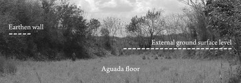
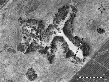
Dunning (Reference Dunning1992:22) notes that clays accumulating on reservoir floors increases retention capacity. Investigating soil profiles of the banks of two water reservoirs at Uxmal and Muluch Tzekel, Dunning (Reference Dunning1992:22–23) also found that soil had been deposited on the rims and that some of these deposits consisted of floor muck, presumably excavated to increase water-holding capacity. Securing the water reservoir from seepage might have been an arduous task over the long-term. Surface data from Xuch adds to this observation and provides a new clue to the long-term formation processes of reservoir berms and their functions in the pre-Hispanic agro-urban Puuc landscape. Field reconnaissance at the aguada in 2007 revealed that dense thicket and tree growth present during previous surveys had concealed from view fragments of a berm, an inclination in relief from the surrounding flatlands (Figure 4), that runs along sections of the ca. 900 m long perimeter of the irregularly shaped landform (Figure 5). At its largest, the berm is about 10 m wide and rises to a height of about 2–3 m above the current exterior ground surface (Figure 6). The shapes of both the exterior and interior berm slopes are roughly linear. The maximum estimated depth of the depression is currently 4 m, but it is difficult to estimate the depth of the reservoir in pre-Hispanic times. The exterior slope of the aguada is moderately steep, while the interior slope of the berm—which merges with the margin of the depression—is very steep. A rough estimate indicates that the reservoir once had a potential water holding capacity of between 50,000 to 100,000 m3 and that at least 5,000 to 10,000 m3 of soil had been used in the construction of the berm. Centuries of continuous silting may have made the depression shallower. The floor of the aguada is distinctly level which does indeed indicate significant silting. On the other hand, since the reservoir has been left unmanaged after the agro-urban landscape was abandoned in pre-Hispanic times, continuous draining may have further excavated the depression. Until a detailed record of sedimentation stratigraphy and history is made available from excavation, a reasonable working hypothesis is that periods of net silting have alternated with periods of net excavation over close to a millennium of managerial neglect. When brought together the evidence from Uxmal and Muluch Tzekel—which demonstrate that aguada berms are anthropogenic and partly constructed from muck excavated from the reservoir floor—and the Xuch data—which indicate that such berms might have formed very large features—is important for understanding the importance of water reservoirs in the pre-Hispanic Puuc Maya landscape.
Interior of the southeastern leg of the water reservoir, looking southeast. The earthen wall is on the left; note Milo Aké May in the far background indicating the size of features. The approximate external ground surface level is shown by a dashed line. The aguada floor is currently markedly level, indicating significant silting. Photo by the author.

Modified detail from Google Earth image of the Xuch aguada (original image accessed May 10, 2008). The diagonal scale indicates the location of the profile drawing seen in Figure 6.

Profile drawing of the water reservoir indicating shapes and dimensions of earthen walls and reservoir floor. Drawing by the author.

With the evidence available at the moment we cannot say how or when the swallow-hole in the aguada at Xuch was sealed, but a reasonable working hypothesis is that the depression was a functioning reservoir when the agro-urban settlement began to evolve during the Late Classic period (a.d. 600–800). Similarly, exactly when the seal ruptured we do not yet know, but it must have been earlier than half a century ago. Perhaps it broke towards the end of the last phase of agro-urban settlement and should be associated with the processes that led to the abandonment of the area during the early phase of the Early Postclassic period (a.d. 1000–1250)?
Nicholas Dunning (personal communication 2009) notes that water reservoirs with open swallow-holes are rare, citing only two other known cases—one at Uxmal, another at the appropriately named Xuchah in the Bolonchen Hills south of the Nohkakab Valley. He also suggests that true open swallow-holes may never have existed at some depressions that formed from initial subsurface collapse followed by subsidence of overlying material. It is clear that we need detailed excavation data from a series of Puuc aguadas in order to understand patterns of similarity and variation in their formation processes and management histories.
Nevertheless, reservoir construction and maintenance must often have involved considerable labor investment to increase storage capacity and control seepage. The permeable qualities of the karst geological structure encouraged treatment of depression walls and floors to increase retention capacity, but very little substantial evidence exists. Already John Lloyd Stephens (Reference Stephens1843) reported on the discovery of wells, platforms, and stone linings buried under several feet of mud in the floor of a dried-up Puuc water reservoir. More recent excavations in an aguada floor at Uxmal, ca. 15 km to the east of Xuch, produced evidence of a stone-lined well (Huchim Herrera Reference Huchim Herrera1991). Extracting water from surrounding saturated strata, a well in the floor extended the water holding season of the reservoir. Wells might also have been constructed in depressions that did not hold any substantial amounts of water but at least were associated with saturated substrata. Although Dunning (Reference Dunning1992:22–23) reports the inclusion of muck in the construction of berms, most of the strata show no evidence of origin in excavated floor sediments. The limited evidence so far available indicates that there are several causative factors to the formation of Puuc water reservoir berms. One contributing factor to the deposition of muck on the depression rim is reservoir maintenance. A berm or earthen wall on the edge of the depression may also have functioned as a protective barrier reducing the catchment area and counteracting excessive silting from surface runoff. But these functional factors are probably relatively minor. The natural formation processes of depressions and the subsequent anthropogenic modification of these landforms into water reservoirs formed part of a wide-ranging and long-term transformation of the Puuc environment into a multi-dimensional agro-urban landscape that involved a number of different biogeophysical, economic, socio-political, and religious aspects.
WATER RESERVOIRS IN PUUC MAYA POLITICAL ECONOMY
Dunning (Reference Dunning1992) suggests—principally on the basis of the greater productivity of the Nohkakab Puuc soils—that this region functioned as a breadbasket for other areas in the northern Yucatan Peninsula where local soilscape was poorer (but where farming was more resilient to climatic anomalies owing to an accessible aquifer). From a World Systems perspective (for recent updates of this broad field of investigation see Hornborg and Crumley [Reference Hornborg and Crumley2007] and Hornborg et al. [Reference Hornborg, McNeill and Martinez-Alier2007]), the export of bulk foodstuffs from the Puuc to neighboring regions and beyond is likely to have strengthened local elite political and economical control of farming populations, cultivable land, and produce. Producing for export seems often to accelerate short-term maximization of production at the expense of maintaining long-term resilient agrosystems (for a couple of archaeological applications of these concepts see Adams [Reference Adams1978] and Alexander [Reference Alexander, Kepecs and Alexander2005]) and puts more pressure on local agro-ecosystems. We are only beginning to understand the detailed relationship between household-based subsistence economies and controlling political economies in the Puuc region (Demarest Reference Demarest1996; Masson and Freidel Reference Masson and Freidel2002), but the scale and distribution of monumental civic-ceremonial building complexes in Maya landscapes suggests that asymmetrical power relations—the basis of economic control and inequality—was a strongly perceptible notion in the day-to-day life of most people (Smith Reference Smith2003). To varying degrees social inequity was present in the perceptions of landscape, in cosmology, in the calendar, in the built environment, in land-use rights, in identity, history, and social memory (Isendahl Reference Isendahl2006b).
But political coercion and economic control was ultimately a matter of social negotiation. In this social process, public large-scale politico-religious ceremony was an important tool for political integration (Inomata Reference Inomata2006). The ceremonial landscape of the pre-Hispanic Puuc Maya seems to have organized a number of different structured locations for integrative political ceremony (generally the same as elsewhere in the Maya lowlands), such as plazas (Inomata Reference Inomata2006), ballcourts (Fox Reference Fox1996), and water reservoirs (Lucero Reference Lucero2006a; Scarborough Reference Scarborough1998). Central locations with high visibility and the capacity to accommodate a large audience are a couple of general characteristics that seem to offer conditions ideal for large-scale public performances serving community-integrating political purposes. The central location of the water reservoir in the agro-urban landscape at Xuch (where there are several plazas, but no ballcourt) is ideal in this regard. Furthermore, located less than 400 m to the north of the central civic-ceremonial core complex, the reservoir is spatially associated with elite sectors of the landscape, similar to the spatial context of water reservoirs at Tikal and thus suggesting a parallel to the rather tightly-knit central political control of water reservoirs there (Scarborough Reference Scarborough1998).
The evidence for a water reservoir berm at Xuch is the most substantial evidence for large-scale water reservoir landform modification so far accounted for in the Puuc region. Evidence of major labor investments in reservoir berms is currently available only from a handful of other pre-Hispanic Puuc settlements, including Muluch Tzekel, Uxmal, and Yaxhom (Nicholas Dunning, personal communication 2009). Whether this reflects differences in social investment, a lack of research, or both still remains to be determined, but I suspect further field research will be rewarding in this regard. The interpretation that the Xuch reservoir formed a key place in the ceremonial landscape of the agro-urban community supplements a strictly functionalistic interpretation of freshwater procurement in a seasonally dry area with permeable geological structure and an inaccessible aquifer. This suggests that the creation of the berm formed part of a long-term construction program that transformed a natural depression to an engineered monumental complex for politico-religious ceremony. Indeed, following Scarborough's (Reference Scarborough, Scarborough and Isaac1993, Reference Scarborough2003) accretive model, the social and economic cost of investing in the transformation of landscape adds to the symbolic and energetic binding to the place.
The central location of the water reservoir in the settlement at Xuch is, however, somewhat unusual. Although there are other examples of centrally located Puuc water reservoirs—cases include Nakaskat and Yaxhom—aguadas are also found at more peripheral locations in Puuc landscapes (Dunning, personal communication 2009). There is also considerable variation in the size and number of water reservoirs at pre-Hispanic Puuc settlements (Dunning Reference Dunning2008). For instance, Nicholas Dunning (personal communication 2009) notes that the water reservoir at Xkipche is much smaller in comparison to the Xuch aguada—despite the two settlements being of comparable size (see Prem Reference Prem2003)—and suggests that the Xkipche reservoir might have had a much greater symbolic than practical value. Such differences were undoubtedly a function of several factors, not least the distribution of fractured bedrock underlying deep deposits of Quaternary soils and a preference for placing civic-ceremonial and residential buildings on well-drained upland soils, but much more detailed comparative regional research is needed to detail and understand morphological, chronological, and contextual variation in the Puuc region and elsewhere. An important conclusion that can be drawn from Karla Davis-Salazar's (Reference Davis-Salazar2001, Reference Davis-Salazar2003, Reference Davis-Salazar2006; Fash and Davis-Salazar Reference Fash, Davis-Salazar, Lucero and Fash2006) and Julie Kunen's (Reference Kunen, Lucero and Fash2006) research is that the political framing of pre-Hispanic Maya water management is potentially heterarchical—that is, it is neither static nor homogenous and it has the capacity to be organized in many different ways (Crumley Reference Crumley, Ehrenreich, Crumley and Levy1995; Scarborough Reference Scarborough2003). The point is that the local evidence from Xuch—chiefly the location and size of the reservoir and the monumentality and labor investment associated with the construction of the berm—suggest central political control of the water reservoir. But this is not the only form of regional water management possible. It might have involved a number of different strategies, including both “bottom-up” and “top-down” systems. In a sense, the tension between these two extremes sets the scene for social negotiation in pre-Hispanic Puuc Maya water politics.
WATER RESERVOIRS IN PUUC MAYA RELIGIOUS SYMBOLISM
Water is central to the human mind, to how we perceive the world, to how we understand our being-in-the-world. The necessity of water for any form of life, the fundamental physical qualities and attributes of water (precipitating, settling, percolating, flowing, evaporating, and so on), and the many daily uses of water (drinking, cooking, sanitation, agricultural, in production, etc.) provide for a rich water symbolism in pre-Hispanic Maya and Mesoamerican cosmology that is well attested from iconographic, epigraphic, ethnohistoric, palaeoethnobotanic, and archaeological research (Bassie-Sweet Reference Bassie-Sweet1996; Baudez Reference Baudez, Breton, Becquelin and Ruz2003; Brady and Ashmore Reference Brady, Ashmore, Ashmore and Knapp1999; Bonnafoux Reference Bonnafoux2006; Cyphers et al. Reference Cyphers, Hernández-Portilla, Varela-Gómez, Grégor-López, Lucero and Fash2006; Dunning Reference Dunning, Breton, Becquelin and Ruz2003; Dunning et al. Reference Dunning, Beach, Luzzadder-Beach, Lucero and Fash2006; Dunning and Houston Reference Dunning and Houston2006; Fash Reference Fash, Andrews and Fash2005; Fash and Davis-Salazar Reference Fash, Davis-Salazar, Lucero and Fash2006; Freidel et al. Reference Freidel, Schele and Parker1993; French et al. Reference French, Stuart, Morales, Lucero and Fash2006; Hellmuth Reference Hellmuth1987; Houston and Taube Reference Houston and Taube2006; Lucero Reference Lucero2006a; Lucero and Fash Reference Lucero and Fash2006; Puleston Reference Puleston and Hammond1977; Rands Reference Rands1953, Reference Rands1955; Scarborough Reference Scarborough1998; Schele and Miller Reference Schele and Miller1986). This body of research offers some important clues on how the water reservoir at Xuch might have been understood in pre-Hispanic cosmology and perceptions of landscape: as a link to and representation of the Underworld; as an axis mundi, a central point in the universe; in the context of an ontology that found the Earth animate; as a symbol of the fertility of the land; and as a sexual metaphor. Some of these aspects have been very well demonstrated in previous scholarship, others need further testing for definitive verification, but they all elucidate how complex and diversified the pre-Hispanic understanding of water reservoirs may have been.
One central theme in Maya cosmology of fundamental bearing here is the strong association between water and the Underworld—Xibalba, “The Place of Fear,” in the Popul Vuh (Tedlock Reference Tedlock1996)—of which there seems to be several expressions in Maya iconography, epigraphy, and ethnohistory (e.g., Bassie-Sweet Reference Bassie-Sweet1996). Hellmuth (Reference Hellmuth1987), among others, suggests that pools of water were associated with the surface of the Underworld in Maya cosmology. Schele and colleagues (Schele and Miller Reference Schele and Miller1986; Friedel et al. 1993) argue that the deceased were taken to the Underworld over waterways by canoe, and then broke the water surface to enter Xibalba. This idea of a “watery Underworld” in Mesoamerican cosmology (Cyphers et al. Reference Cyphers, Hernández-Portilla, Varela-Gómez, Grégor-López, Lucero and Fash2006) is likely to reverberate with the nature of the karst environment on the Yucatan Peninsula, where subterranean water-filled hollows, caves, and reservoirs are regionally common. The Xuch water reservoir might symbolically have alluded to the Underworld as a pool of water, but also as a conduit—through the swallow-hole, the xuch—to the Underworld. The latter point is supported by a large volume of analogous archaeological, iconographic, epigraphic, linguistic, and ethnographic evidence that demonstrate that caves and cenotes in particular—but also other cavities in the Earth's surface—were thought of as links between the physical world of the living, and the Underworld (Bassie-Sweet Reference Bassie-Sweet1996; Brady Reference Brady1997; Brady and Ashmore Reference Brady, Ashmore, Ashmore and Knapp1999; Brady and Prufer Reference Brady and Prufer2005; Brady and Veni Reference Brady and Veni1992; Brown Reference Brown, Lucero and Fash2006; Brown and Emery Reference Brown and Emery2008; Coggins and Shane Reference Coggins and Shane1984; Earle Reference Earle and Staller2008; Fash and Davis-Salazar Reference Fash, Davis-Salazar, Lucero and Fash2006; French et al. Reference French, Stuart, Morales, Lucero and Fash2006; Houston et al. Reference Houston, Stuart and Taube2006; Lucero Reference Lucero2006a; Prufer and Brady Reference Prufer and Brady2005; Scarborough Reference Scarborough1998; Schele and Freidel Reference Schele and Freidel1990; Sievert Reference Sievert1992; Stone Reference Stone1995; Thompson Reference Thompson1959). In the Puuc region—where there are no cenotes and almost no caves—water reservoirs probably played the same symbolic role of a link between the different dimensions of existence (Dunning Reference Dunning2008). The unusually clear physical link at Xuch between a water reservoir and a hydrological swallow-hole—the conduit in the karst bedrock literally linking the surface with the underground water system—is particularly important in that it substantiates the interpretation of Puuc water reservoirs as being associated with the same kind of symbolism as are caves and cenotes elsewhere in the Maya lowlands.
A related theme in Maya cosmology is the ordering of space according to a quadripartite model with four directions and a central point (Ashmore Reference Ashmore1991; Freidel et al. Reference Freidel, Schele and Parker1993; Hanks Reference Hanks1990; Redfield and Villa Rojas Reference Redfield and Rojas1934; Schele and Freidel Reference Schele and Freidel1990; Taube Reference Taube, Gómez-Pompa, Allen, Fedick and Jiménez-Osornio2003). This basic model of ordering space appears to have been an essential component of southern Mesoamerican cosmology since at least the early first millennium b.c. (Taube Reference Taube, Gómez-Pompa, Allen, Fedick and Jiménez-Osornio2003:461). Among the Maya, it seems to have influenced the organization of social space and guided planning and ordering of the built environment at several levels. Fields, houses, household groups, neighborhoods, ceremonial buildings and plazas, and entire urban landscapes have convincingly been interpreted using this model (Ashmore Reference Ashmore1991, Reference Ashmore, Danien and Sharer1992; Hanks Reference Hanks1990; Taube Reference Taube, Gómez-Pompa, Allen, Fedick and Jiménez-Osornio2003). Furthermore, the horizontal quadripartite model was linked to a vertical conception of cosmos consisting of three layers; the Celestial world, the human world, and the Underworld. The different horizontal levels were vertically joined together through the central point (Schele and Freidel Reference Schele and Freidel1990:66–72). In this way of ordering and understanding the world, the central point matches Eliade's (Reference Eliade1959a, Reference Eliade1959b) concept of axis mundi, the world axis that is the center of creation and connects the levels of cosmos (Brady Reference Brady1997; Brady and Ashmore Reference Brady, Ashmore, Ashmore and Knapp1999; Redfield and Villa Rojas Reference Redfield and Rojas1934).
If the reservoir, as argued above, was conceptually associated with a vertical conduit in the minds of the pre-Hispanic Xuch inhabitants, then its location at the horizontal center of the community suggests that it was also thought of something along the lines of an axis mundi, even though the actual axis—the xuch—had been plugged and lay beneath several meters of water under extended periods of the year. This is an interpretation that parallels Brady's (Reference Brady2004) convincing argument that household underground water cisterns (in addition to their practical importance) were symbolic caves and center points. As discussed above, these cisterns (chultunob) are compulsory components of most residential groups at Xuch and in the Puuc in general. These interpretations suggest that the association of water sources with the center might have permeated pre-Hispanic Puuc Maya thought and was reproduced in the ordering of space at different scales, from the landscape level to that of the household compound.
Iconographic, epigraphic, and ethnohistoric evidence also suggest that the pre-Hispanic Maya in some sense conceptualized the universe as animate (e.g., Brown Reference Brown2004). Yucatec Maya is rich in metaphors and symbolism that suggests an animate conceptualization of the Earth. For instance, the different senses of the Xuch toponym can be interpreted to indicate a place where the Earth gulps water through its mouth, the swallow-hole (Barrera Vásquez Reference Barrera Vásquez1995:953–954). The idea and character of an animate Earth among the pre-Hispanic Puuc Maya might have reverberated with the geophysical behavior of the karst landscape: solution of limestone creating remarkable landforms, water rapidly and forcefully disappearing into the underground, and currents of air entering and leaving structural cavities, flowing through underground networks of vertical and horizontal channels. Powered by hydrostatic pressure and temperature differences, the latter phenomenon might have supported an image of a breathing Earth, of inhalations and exhalations. In the Puuc karst environment, wind and water in motion acted to shape the face of the landscape and give breath to the Earth (Bruchez Reference Bruchez2007). Linguistic, epigraphic, and iconographic evidence suggests that the pre-Hispanic Maya made a semiotic connection between wind, breath, spirit, and soul and that they may have believed that the wind originated from underground (Barrera Vásquez Reference Barrera Vásquez1995:266, 365, 530; Bassie-Sweet Reference Bassie-Sweet1996:10; Houston et al. Reference Houston, Stuart and Taube2006:143, 149). Houston and colleagues (Reference Dunning and Houston2006:149) link the Wind God, the different meanings of ik' (a term with multiple senses, including wind, breath, spirit, and soul [Barrera Vásquez Reference Barrera Vásquez1995:266; Houston et al. Reference Houston, Stuart and Taube2006:143]), and the notion of caves as breathing. Draughts, winds, and currents of air flowing underground through karst structural channels and in and out of surface cavities probably substantiated perceptions of the Earth as animate. It also seems to relate to the idea of spirits wandering between the Celestial world, the human world, and the Underworld, feeding a perception of vertical karst cavities as conduits.
Parallel to the idea of karst wind, water, and soil dynamics substantiating perceptions of a breathing, animate Earth and of wandering spirits, the exchange and flow of fluids—of substances entering and leaving Earth-penetrating cavities—bring to mind sexual metaphors. Even though the symbolic links between landforms, sexual metaphors, political power, and fertility among the pre-Hispanic Maya is less than lucid, there is evidence to suggest certain associations. For instance, Brady (Reference Brady1988; see also Heyden Reference Heyden and Benson1981 for a Mesoamerican perspective) argues that the pre-Hispanic Maya symbolically understood caves as wombs and Amrhein (Reference Amrhein2001) has shown that the Puuc region abounds with monumental stone phalli, demonstrating that pre-Hispanic Maya semiotics used several different metaphors with sexual references. Amrhein (Reference Amrhein2006) discusses how certain sexual symbols were associated with rulership and political prowess and were important paraphernalia in political ceremonies. A well-known example is the bloodletting of royal genitals in Classic period political ceremony (Schele and Miller Reference Schele and Miller1986). Amrhein (Reference Amrhein2006) also argues that Puuc phallic sculptures were associated with the Maya World Tree, another representation of the axis mundi. There seems also to have been a symbolic bond between sexual reproduction and agricultural fertility in pre-Hispanic Maya symbolism (admittedly not an entirely unique idea), and maize, the principal crop in the Puuc region as elsewhere in the Maya lowlands, occupies a key role in pre-Hispanic Maya cosmogony (Freidel et al. Reference Freidel, Schele and Parker1993; Saturno Reference Saturno2006; Taube Reference Taube2006). In this context, the position of the water reservoir in the extensive zone of deep and fertile soils might have amplified a symbolic union of soil and water as the basis of maize production and ultimately as life-giver of pre-Hispanic Puuc Maya agro-urban economies.
In short, the symbolism associated with water reservoirs in the Puuc appears to have been powerful, multifaceted, and complex, suggesting that these locations were among the most important places in the local perception of landscape. But the symbolic importance of water must not be assumed to have been a static constant. Several scholars argue that the urgency and character of water symbolism in pre-Hispanic Maya cosmology and ritual change over time, at least to some extent in response to climatic anomalies and events. Bonnafoux (Reference Bonnafoux2006) finds a link between Terminal Preclassic period drought events and a shift in iconography towards a stronger focus on aquatic motifs, and Normark (Reference Normark2006) correlates increased aridity with intensified ritual activity at caves to the east of the Puuc region. Dunning (Reference Dunning2008) suggests that reservoir construction at Uxmal, Tzemez Akal, and Xcoch might have been in response to increasingly arid conditions in the Terminal Preclassic and the Terminal Classic periods. The role of climatic anomalies, shifts, and drought events in the history of the Xuch water reservoir is clearly an area for future study.
CONCLUSION
The central placement of the reservoir in the Xuch agro-urban landscape suggests it functioned as a settlement hub; being a member of a Classic period community revolved, in many different ways, around the water reservoir. Indeed, the data suggest that the importance, or “weight,” of water in Puuc Maya economics, politics, cosmology, and ritual can hardly be overestimated.
The evidence from Xuch demonstrates that water management played an integral part in the long-term cultural transformation of environment that is still visible in the Puuc landscape, almost a millennium after major abandonment of the region in the Early Postclassic. Owing to a combination of different interacting biogeophysical (climate, topography, and geomorphology) and sociocultural (e.g., politics and economics) factors, the Classic period Puuc Maya were particularly dependent on the successful management of a water resource that was in great demand from large sub-regional populations, an extractive political economy, and agro-production for export, but in very short supply. Puuc Maya water management was conspicuous in that it focused on the construction, maintenance, and control of open still-water reservoirs. Reservoirs in the Puuc region were elaborated from topographic depressions that form naturally in the landscape only where pockets of relatively deep Quaternary soils coincide with fractures in the underlying limestone bedrock. Taking control of such resources was a central elite strategy to dominate the political landscape.
At Xuch, evidence for the pre-Hispanic conversion of a natural depression in the terrain into a managed water reservoir with considerable volumetric storage capacity, its central location on the landscape and proximity to the civic-ceremonial core complex, and the labor investment needed for constructing the berm running the perimeter demonstrates that the water reservoir was a key component in the local agro-urban landscape. The water reservoir at Xuch served as a place for large-scale public political ritual—a mechanism for identity formation, community integration, and political legitimization—alongside other ceremonial spaces in Maya landscapes, such as ballcourts and plazas. Local and comparative evidence on the sacred symbolism of water, of Earth-penetrating cavities, and concepts of the center in pre-Hispanic Maya cosmology distill at the Xuch reservoir and accentuate its significance and centrality in the sacred perception of landscape and place.
RESUMEN
En las tierras bajas mayas, el manejo prehispánico del agua era una actividad de componentes múltiples, de diversidad a través del espacio y que cambiaba a través del tiempo. En la región Puuc del área noroeste de la Península de Yucatán, que se caracteriza por mostrar temporadas de sequía, las aguadas grandes y “lagunas” dominaban la estrategia de manejo del agua desde el período clásico tardío hasta el posclásico temprano (600–1250 d.C.). Las aguadas se construían en depresiones naturales y se modificaban para incrementar la capacidad de almacenamiento del agua pluvial y para controlar la filtración. Las aguadas fungían como elementos de orientación y elementos centrales en el urbanismo prehispánico del área Puuc y las depresiones fueron asimismo objetos claves para atraer a la población a que se asentara. La formación de depresión se asocia con los huecos geo-hidraulógicos como sumideros, o “xuch” en maya yucateco, ubicados en la roca madre y a través de los cuales se drenaba el agua pluvial durante la temporada de lluvias. El simbolismo poderoso de cuerpos de agua y de las oquedades en la cosmología maya hicieron que los lugares en donde se encontrasen aguadas fuesen sitios importantes en el paisaje sagrado del área Puuc. Además, los elementos que se movían y actuaban para moldear el paisaje kárstico alimentaban un concepto de la Tierra como algo animado. Si bien las aguadas fueron utilizadas en estrategias de riego por ollas en los solares de cultivo cercanos y en las unidades domésticas de la gente acomodada para el consumo, su significado principal descansaba en su capacidad como símbolos de potencia política. Al vincular las metáforas de sexualidad con la fertilidad agrícola y de proceso político de la élite gobernante, las aguadas fueron lugares clave en los ritos ceremoniales de los paisajes agrícolas urbanos y formaban una parte esencial de la identidad y auto imagen de los mayas del área Puuc.
ACKNOWLEDGEMENTS
I thank Emigdio Aké May for assistance during field reconnaissance at Xuch and Lorraine Williams-Beck of the Universidad Autónoma de Campeche for invaluable logistical support and for translating the abstract into Spanish. I am very grateful indeed for the expert comments, suggestions, new information, and critique offered by Karla Davis-Salazar, Nicholas Dunning, and Vernon Scarborough. Their advice has been very helpful to improve the ideas in this paper. Needless to say, all remaining shortcomings in this work are entirely of my own making. Field reconnaissance reported here was supported by the Krapperup Foundation and the manuscript was prepared as part of the research project “Ecology, Power, and Religion in Maya Landscapes” funded by the Bank of Sweden Tercentenary Foundation.