





Measurements played a fundamental role in the organization of the Mesoamerican built environment. They were used not only to determine the dimensions and forms of architectural structures but also, in many cases, to embed temporal and ritual concepts into measurable elements. Evidence indicates that the principal units of measurement were standardized through the use of measuring instruments (Brinton Reference Brinton1885; Lucet and Alvarado-León Reference Lucet and Alvarado-León2025; Rojas Rabiela Reference Rojas Rabiela, Vera and García Acosta2011). The numerical entities associated with these units also appear to have been deliberately selected to relate the built environment to astronomical and calendrical cycles, incorporating principles consistent with the cosmological frameworks documented throughout Mesoamerica (Lucet and Alvarado-León Reference Lucet and Alvarado-León2025; Sugiyama Reference Sugiyama1983, Reference Sugiyama1993, Reference Sugiyama, Morley and Renfrew2010).
Despite the importance of measurement in understanding the relationship between architecture, urbanism, ritual practice, and cosmology, current knowledge of Mesoamerican systems for length measuring remains fragmentary. This limitation stems primarily from the restricted spatial and temporal scope of the available sources. Studies based on colonial documents have focused predominantly on the Nahuatl-speaking region (Castillo Reference Castillo1972; Clark Reference Clark2008, Reference Clark, Morley and Renfrew2010; Dehouve Reference Dehouve2011, Reference Dehouve2014; Matías Alonso Reference Matías Alonso1984; Orozco and Berra Reference Orozco y Berra1880; Valencia Rivera Reference Valencia Rivera, Rosado and Barrio2018), where the extensive vocabulary and glyphs associated with units of measurement demonstrate the central role of the human body in metrological systems. Historical evidence from the Maya area has received comparatively limited attention (Brinton Reference Brinton1885; Ciudad Real and Coronel Reference Ciudad Real, Coronel and Martínez Hernández1929:40).
In parallel, research based on the analysis of architectural and urban complexes has concentrated on a limited number of sites, including Teotihuacan (Almaráz Reference Almaráz, Almaráz, Andrade and Escalante1865; Drewitt Reference Drewitt, McClung and Rattray1987; Drucker Reference Drucker1974; Sugiyama Reference Sugiyama1983, Reference Sugiyama1993, Reference Sugiyama, Morley and Renfrew2010), Tenochtitlán (Clark Reference Clark2008, Reference Clark, Morley and Renfrew2010), Cacaxtla (Lucet Reference Lucet2015, Reference Lucet2020), Xochicalco (Lucet and Alvarado-León Reference Lucet and Alvarado-León2025), and the Puuc region (O’Brien and Christiansen Reference O’Brien and Christiansen1986). Collectively, these studies focus on specific centers in the central Mexican highlands during the Classic, Epiclassic, and Postclassic periods, as well as a restricted portion of the Maya region during the Late Classic period. Consequently, the broader diversity of Mesoamerican measurement systems across cultural regions and chronological phases remains largely unexplored.
To improve our understanding of how Mesoamerican architectural practices were developed, transmitted, and transformed over time, it is necessary to extend the analysis of measurement to a broader range of regions and cultural contexts. Mesoamerican societies developed various systems characterized by specific combinations of units and numerical entities. These systems were standardized and applied in response to locally defined construction practices and cosmogonic frameworks of the respective regions. Like other widely shared but locally adapted formal elements, such as the talud-tablero architectural principle, these systems contributed to the production of distinctive architectural identities across Mesoamerica.
In Oaxaca, pre-Hispanic architecture and urbanism expressed regional identities. Among these traditions, Mitla is distinguished by its characteristic floor plans, the absence of monumental pyramidal structures, and the geometric complexity of its architectural ornamentation. The regularity and rhythm of these designs suggest a planning process based on measures, proportions, and carefully structured spatial layouts. Yet, despite these features, the system underlying the architecture of Mitla has never been systematically characterized.
Previous studies have reached contrasting conclusions. Horst Hartung (Reference Hartung1983) identified a module of approximately 4.50 meters in his analysis of the façades of the Hall of the Columns (Hall 16). By contrast, Corner (Reference Corner1899:36, 40) interpreted the apparent irregularities of this hall as evidence that precise measurement was absent from Mitla, a view later echoed for Monte Albán (Peeler and Winter Reference Peeler and Winter2011:9). These interpretations reflect the application of modern metric expectations in the search for standardized units rather than an understanding of the principles governing Mesoamerican systems.
Given the architecture distinctiveness of the Oaxaca region and the uniqueness of Mitla, this study examines the possibility that a locally defined system of measurement underlies its architectural design. It undertakes a detailed analysis of the dimensions of structural elements to investigate the interplay between units, numerical values, and spatial configurations. The resulting patterns provide the basis for proposing that temporal, cosmogonic, and social values were integrated into architectural space through the rigorous control of numerical relationships embedded in the measurement design.
The methodological approach employed to reconstruct the architectural the system of Mitla is based on an analysis of the La Iglesia (Church), El Arroyo, and Las Columnas (Columns) groups. Although these complexes were modified during the colonial era, they preserved sufficient dimensional regularities to allow analysis.
The analysis presented here is based on the premise that a system of linear measurement consists of one or more units generated by combining a common anthropometric reference with a numerical value (here termed the generative base). For example, the two units identified in Xochicalco share a common unit, which is an anthropometric core of 21 cm (the palmo) and are generated through numerical—referred to here as generative bases—of seven and eight (Lucet and Alvarado-León Reference Lucet and Alvarado-León2025). These combinations produce units measuring 1.47 m and 1.68 m. In this framework, unit length is not fixed a priori but emerge from the relationship between an anthropometric module and its numerical multiplier.
The principle for generating a specific length can be summarized as follows:
anthropometric core × generative base = unit of measurement unit of measurement × numerical entity = length
Hereafter, the term “numerical values” is used to refer interchangeably to both generative base and numerical entity.
Similarly, “measurement” refers to the expression of a distance through the combination of a pre-Hispanic unit and a numerical entity, whereas “dimension” refers to the same distance expressed in modern metric values.
This study reconstructs a previously undocumented Zapotec system of measurement, demonstrating the Mitla employed principles of architecture planning that differ substantially from those documented elsewhere in Mesoamerica.
Background
Mitla
During the Preclassic period, the Zapotecs settled on a strategic hill in the Central Valleys of Oaxaca, where they founded the city, now known as Monte Albán. Between a.d. 200 and 750, this settlement became the political and ritual center of a vast regional network. However, it was gradually abandoned in the eighth century (Marcus Reference Marcus2008:161–172). Subsequently, the Mixtecs, who were settled to the north and west of the Central Valleys, expanded their exchange networks and, in the process, formed marriage alliances with Zapotec lineages. This favored the reconfiguration of the regional political landscape (Marcus Reference Marcus2008:174–176). In this context, several settlements in the Tlacolula Valley, including Yagul and Mitla, became increasingly important as strategic nodes toward the Isthmus of Tehuantepec. Yagul reached its peak between a.d. 700 and 1200, boasting an architectural complex comprising palaces, squares, a ballcourt, and residential areas organized into terraces (Bernal and Gamio Reference Bernal and Gamio1974).
Mitla’s development took place between a.d. 1000 and 1521 (Pohl Reference Pohl and Kowalski1999:179). Its floor plans bear similarities to those of the palaces of Yagul, revealing a shared architectural tradition, although both incorporate elements inherited from Monte Albán (Robles García Reference Robles García2016:42). Unlike Monte Albán and Yagul, which functioned as centers of political power, Mitla was primarily a sacred site. Rulers from different ethnic groups came here to consult oracles and resolve disputes through the mediation of the priest (Pohl Reference Pohl and Kowalski1999:177). It is now widely accepted that the main builders of Mitla were Zapotec, with Mixtec groups incorporated during the Late Postclassic period (Robles García and Moreira Quirós Reference Robles García and Moreira Quirós1984, Reference Robles García and Moreira Quirós1990:49–50). The Mexica presence in the region occurred later and is primarily evident in the adoption of Nahuatl placenames, such as Mictlán (“place of the dead’), which the Mexicas gave to the ancient Lyobaa (“place where souls rest”) (Robles García Reference Robles García2016:42, 45).
Mitla’s structures are organized into five architectural groups: the Church, the Arroyo, the Columns, the Adobe, and the South (Figure 1). The Church and the Arroyo groups have regular floor plans with elongated buildings arranged around three quadrangles. They feature lintels adorned with red linear paintings in the Mixtec style, depicting a fusion of cosmogonic elements from the Zapotec, Mixtec, and Toltec-Chichimeca cultures. According to Deland Pohl (Reference Pohl and Kowalski1999:193), these elements reinforce the ritual and pan-regional significance of Mitla. The Group of the Columns is distinguished by its elevated platforms, enclosed quadrangles, and the tombs associated with the founding lineages. The Adobe and South groups each have a single quadrangle and an elevated eastern platform. Due to their poor state of conservation, the latter two could not be included in the study.
Architectural groups of Mitla (Holmes 1895).

Figure 1 Long description
Contour map with a central drainage line, dashed paths and five labeled architectural groups with building plans. The drainage line runs from near the upper center downward through the middle and connects to a wider channel that runs across the lower part of the map. Multiple contour lines span the full map area. Text at the top includes, FIELD COLUMBIAN MUSEUM and, ANTHROPOLOGY. The main title reads, SKETCH MAP OF RUINS OF MITLA. Smaller text below the title includes, Letters on buildings indicate and, The point of view of the panorama is at the end of east of east of part of and, Scale about 100 ft. to 1 inch. Group of the Catholic establishment appears in the upper right, drawn as a rectangular walled compound with interior rectangular rooms and a small symbol at the top of the plan. A north arrow is printed near this area. Group of the Columns appears at the right center, drawn as a larger compound with multiple rectangular buildings and enclosed courts. Letter labels visible within this group include E, F and I. Adobe Group appears at the left center, drawn as a smaller set of structures including one large rectangle and two smaller rounded rectangles nearby. Arroyo Group appears near the center left, drawn as several rectangular enclosures and buildings. Letter labels visible within this group include G and H. South side group appears at the lower right, drawn as a compound with multiple rectangular elements. Letter labels visible within this group include K and L. Dashed paths connect and pass between the groups, including a dashed path running down the right side toward the lower channel and another dashed path running from the left side toward the central area.
The construction sequence of these groups has been inferred primarily through stylistic comparisons and assessments of construction quality (Kubler Reference Kubler1990:171; Marquina Reference Marquina1990:371–389). Open quadrangles, characteristic of the Adobe and the South groups, are regarded as deriving from the spatial traditions of Monte Albán and are associated with the earliest construction phases. In contrast, the Church and the Arroyo groups correspond to later stages while the Group of the Columns incorporates features of both traditions, suggesting an intermediate stage.
A more recent chronology, based on archaeological evidence and the study of mural paintings on the lintels, has been proposed by Lind (Reference Lind2015:159–160). According to this interpretation, the South Group dates to the Monte Alban period and was abandoned in a.d. 850. The Adobe Group and the first phase of the Arroyo Group were subsequently constructed “perhaps” around a.d. 1200, the former functioning as a temple and the latter as a palace. During the Late Postclassic period, new palace-temple complexes were erected, including the Church Group and the Group of the Columns, while the Arroyo group underwent substantial remodeling.
Measurement in Mesoamerica
The most widely studied measurement system in Mesoamerica is based on a unit equivalent to approximately 1.68 meters. This conclusion is based on studies of historical sources of the sixteenth century, including property records and ancient dictionaries. Various units and anthropometric references were identified. The most frequently cited units are the maitl, associated with a person’s wingspan and height, and the yollotli, equivalent to half a maitl and generally considered comparable to the Spanish vara. Archaeological analysis has corroborated these units, with the yollotli unit ranging from 0.80 to 0.84 m in Teotihuacan (Almaráz Reference Almaráz, Almaráz, Andrade and Escalante1865; Drewitt Reference Drewitt, McClung and Rattray1987; Sugiyama Reference Sugiyama1983, Reference Sugiyama1993, Reference Sugiyama, Morley and Renfrew2010), as well as in monuments and architectural complexes in Tenochtitlan, Cacaxtla, and Xochicalco (López Luján Reference López Luján2010; Lucet Reference Lucet2015, Reference Lucet2020; Lucet and Alvarado-León Reference Lucet and Alvarado-León2025).
The recognition of a second unit measuring approximately 1.47 meters emerged from studies in the Puuc region. O’Brien and Christiansen (Reference O’Brien and Christiansen1986) identified this unit in Chichén Itzá, Uxmal, and Kabah and named it zapal based on colonial Mayan dictionaries. Although the zapal and maitl differ in length, they share a similar anthropometric reference (a man’s height) and are constructed using the same core with different generative bases. This unit has also been documented in the central highlands, where it plays a prominent role in the architecture and mural painting of Cacaxtla as well as in the structures of Xochicalco (Lucet Reference Lucet2015, Reference Lucet2020; Lucet and Alvarado-León Reference Lucet and Alvarado-León2025).
Because the sites in the Puuc area and those in central Mexico are contemporary, the presence of this unit cannot be interpreted as the result of unidirectional influence. Instead, it suggests the complex processes of circulation, adaptation, and resignification of the measurement systems. To avoid attributing them directly to a specific culture, Lucet and Alvarado-León (Reference Lucet and Alvarado-León2025) proposed naming them U7 and U8 to emphasize their shared anthropometric base of 0.21 m. In the most emblematic structures and mural paintings of Xochicalco and Cacaxtla, this shared base enables lengths compatible with both units.
Furthermore, the Mesoamerican concept of space has been suggested to be anisotropic. This implies that the units used to measure the size of a structure may vary depending on the orientation of the walls. For example, in Xochicalco, unit U8 is primarily used on the north and south walls, whereas unit U7 is primarily used on the east and west walls. This suggests that the units were associated with specific symbolic content in a differential manner (Lucet and Alvarado-León Reference Lucet and Alvarado-León2025).
The selection of the numerical entities associated with the units was not based solely on technical or instrumental criteria but also allowed semantic content to be integrated into the main architectural elements. At Xochicalco, the repeated use of number 12 in emblematic buildings linked the architecture to solar cycles. Meanwhile, in Teotihuacan, urban planning incorporated multiple numerical values derived from cosmic cycles to organize the main axes and monumental complexes (Sugiyama Reference Sugiyama1983, Reference Sugiyama1993, Reference Sugiyama, Morley and Renfrew2010). This evidence demonstrates that, in Mesoamerica, measurement operated as a culturally coded system in which units and numerical entities varied according to the local context, spatial function, and symbolic meaning.
Although previous studies have documented the circulation and reinterpretation of various systems in different regions of Mesoamerica, Mitla builders did not use any of them. This study aims to reconstruct Mitla’s measurement system and the principles behind its construction. It also seeks to establish the criteria used to select the numerical values that define length.
Corpus and methods
Corpus
The data considered in this study are selected according to criteria aimed at identifying elements that play a structuring role in the organization of architectural space. In other words, the focus is on elements that define the location, form, and relationships of the main components. Because of the nature of ancient constructions, elements affected by unreliable reconstructions or deterioration that prevented accurate measurements are excluded from the sample.
The Church Group, the Group of the Columns, and the Arroyo Group consist of three complexes, organized around quadrangles surrounded by three or four buildings. Following the nomenclature established by Holmes and still in use today, the complexes of the Church Group are designated A, B, and C; those of the Group of the Columns are designated D, E, and F, and those of the Arroyo Group are designated G, H, and I (Holmes Reference Holmes1897).
Following terminology used by Lind (Reference Lind2015), a building is designated a “room” when it has a single doorway, whereas those with three doorways are classified as “hall.” The central open area of a complex is referred to as a “quadrangle.” Its sunken central space is termed a “patio” when it is enclosed by four buildings that define the corners of the quadrangle, and a “plaza” when it is open on one side and bounded by three buildings. The elevated area surrounding the sunken space is referred to as a walkway.
The rooms and halls surrounding the patios and plazas are numbered clockwise from 1 to 35. To refer to a specific façade, the room or hall number is combined with the orientation of the corresponding wall. For example, the south façade of Hall 5 is designated as 5S. The analyzed corpus comprises three architectural groups, nine complexes, nine quadrangles, and a total of 28 rooms or halls.
During the colonial period, buildings were converted for new use. A convent was established within the Church Group and a religious enclosure was constructed. Complex A was used as a stable, Complex B as housing the clergy, and Complex C as a religious space (Robles García and Moreira Quirós Reference Robles García and Moreira Quirós1984; Reference Robles García and Moreira Quirós1990:69). The colonial church occupied the center of Complex C’s Plaza (Figure 2). The spaces in other complexes were primarily used as warehouses. The first travelers to visit the site at the beginning of the nineteenth century recorded that the local population occupied several structures, particularly in the Group of the Columns and the Arroyo group (De Humboldt Reference De Humboldt and Alvarez1900). The systematic looting of materials used to construct houses in modern villages has considerably weakened the buildings.
Colonial church. Photography by the author.

Owing to growing interest in archaeology and travelers’ accounts, various consolidation and restoration projects have been undertaken. The most notable interventions took place in the Group of the Columns. Leopoldo Batres conducted the first intervention in 1901 (Batres Reference Batres1908), Alfonso Caso (1937–1938), Lorenzo Gamio (1962), and John Paddock (1973); Agustín García Vega also worked on the Church Group between 1921 and 1925 (Robles García and Moreira Quirós Reference Robles García and Moreira Quirós1990:67–73). These interventions included closing openings made during the colonial period, removing later additions (except for the church and its annex), consolidating or reconstructing jambs and lintels, and stabilizing walls at risk of collapse. The platform that supports Complex D, Hall 16, and its staircase were also rebuilt. The rest of the structures remained essentially in the condition in which they were photographed in the second half of the nineteenth century (Charnay Reference Charnay1863).
The following dimensions were excluded from the analysis: width of Hall 7, length of Hall 10, length of the doorway in Façade 12S, width and length of Plaza C, and dimensions of Rooms 17 and 19.
Data recording
Atzompa, Yagul, and the architectural groups of Mitla were documented using aerial photogrammetry in 2020 and 2022. Flight parameters were calculated to achieve a resolution of 1 cm/pixel (GSD = 1 cm). The geo-referenced coordinates obtained using the GNSS system were then employed to scale the models and improve their metric accuracy. The dimensions of the architectural plans are obtained using these models.
A distanciometer was used to record distances within the tombs in Plaza F as well as the pillars and doorways of the Arroyo Group. The Tomb of Suchilquitongo was measured with a total station in 2005. The façades of the Church and Columns groups were recorded using terrestrial photogrammetry, and orthomosaics with a resolution of 1 mm per pixel (GSD = 1 mm) were generated. This resolution allowed the dimensions of the doorways and pillars to be accurately obtained.
Method of analysis
The data were organized into groups of comparable dimensions according to the architectural category and spatial function of the measured elements (Table 1). The widths and heights of the doorways and pillars were considered, as well as the widths and lengths of quadrangles, patios and plazas, and tombs. Those facing north or south were classified as “H,” while those facing west or east were classified as “V.”
Quantification of measurable elements

Table 1 Long description
Counts of architectural elements are listed for three groups and an overall total: facades with doorways, doorways, pillars, quadrangles, and patios and plazas. Overall, doorways are the most frequent element with 64, followed by pillars with 36 and facades with doorways with 28. Church Group and Arroyo Group match on facades with doorways at 10 each, doorways at 24 each, pillars at 14 each, and quadrangles at 3 each. Group of the Columns is lower on most measures, with 8 facades with doorways, 15 doorways, 8 pillars, and 3 quadrangles. Patios and plazas are the least common element overall at 7, with Church Group and Group of the Columns at 2 each and Arroyo Group slightly higher at 3. Totals reflect summed counts across groups and do not indicate size, condition, or significance of the elements.
Identifying a regular pattern in the dimensions of doorways and pillars in different architectural groups led to an initial hypothesis regarding the units of measurement. To test this hypothesis, data from the Church Group, the plants of which were particularly uniform, were used. After verifying the units, they were applied to other groups to assess their consistency and scope across the entire site.
For the purposes of this study, a pattern is defined as the consistent application of specific units and numerical values in accordance with the constructive logic. Therefore, a solution is considered valid if conceptual rules are consistently applied to different architectural contexts. Any exceptions that cannot be explained by these rules are incorporated into the analysis only if the corresponding architectural element is significant enough to justify an exceptional solution.
Based on the result, the analysis focused on interpreting the measurements considering that the selection of numerical units and specific entities responds to precise criteria. The relationships between the properties of the construction elements (architectural category, group membership, and position within the complex) and the components of the measure (generative basis of the numerical units and entities) were examined to identify regularities and significant variations.
Margin of tolerance
The current dimensions of archaeological structures may differ by a few centimeters from the original measures taken from standardized references. This is partly because the organic materials used for measurement tools are susceptible to wear and tear due to humidity variations. These factors led to fluctuations in the measurement process. In addition, the ground settlement and aging of building materials alter the original dimensions. To account for the discrepancies between the current dimensions and original measures, a tolerance range was incorporated into the dimensional analysis.
This range is defined by the observed variability in the widths of the Church Group doorways and pillars. This variability corresponds to a fluctuation of ± 2 cm around the central value of each unit, and this range was adopted as the tolerance associated with the identified units. This margin is adequate, because it represents approximately 1 percent of the Mitla units of measurement, which are almost two meters in size.
The tolerance range is proportional to the number of times a unit is multiplied by it. However, as the identified units differed by only 8 cm, applying this margin to dimensions exceeding 35 m caused ambiguity in the identification of the units used. In these exceptional cases, the measurement defined by the most frequent numerical value among the analyzed dimensions in the closest context was adopted.
Measurement units
Identification of the units
To identify previously undocumented units of measurement, the analysis first examines a small, homogeneous corpus that likely reflects the use of whole units. The doorways and pillars meet these conditions and are in an excellent state of preservation because of the size and quality of the stones used, which protected them from looting and structural deterioration (Figure 3).
Dimensions of the openings and pillars on Façade 1S. Image by the author.

On the same façade, the dimensional variations of the doorways and pillars did not exceed 1 cm, allowing average values to be used without deviating substantially from the original dimensions (Table 2). The distribution of these dimensions revealed recurring groupings that were interpreted as ranges corresponding to different units of measurement and acceptable construction tolerances.
Dimensions of doorways and pillars on façades

Table 2 Long description
Rows list individual buildings within three site groups and their quadrangle letter, height in meters, plus counts and average dimensions for doorways and pillars. In the Church group (A to C), building heights are about 1.98 to 2.02 m; doorway averages are tightly grouped around 1.82 to 1.86 m, and where present, pillar averages are about 1.87 to 1.97 m. Several Church buildings in quadrangle A report one doorway and no pillar measurements, while most buildings in B and C report three doorways and two pillars. In the Group of the Columns (D to F), heights range wider, from about 1.76 to 2.34 m, and doorway averages are generally larger, reaching about 2.42 m in one F building; pillar averages also peak here at about 2.61 m. Quadrangle D entries list one doorway each and no pillar data, with one doorway average missing. In the Arroyo group (G to I), heights are about 1.96 to 2.00 m; most buildings have three doorways averaging about 1.85 to 1.86 m and two pillars averaging about 1.87 to 1.93 m, while several G buildings have one doorway and no pillar data. Dashes indicate missing measurements, so comparisons should focus on rows with reported averages and similar quantities.
Most of the values are concentrated in three main ranges:
• Range 1: 1.82–1.87 m (52 samples, including 48 doorways and four pillars) in two groups, six complexes, and 20 façades;
• Range 2: 1.91–1.97 m, with 27 samples (three doorways and 24 pillars) in three groups, five complexes and 15 façades;
• Range 3: 2.14–2.18 m, with 12 samples (six doorways and six pillars) concentrated in one group, two complexes, and three façades, respectively.
Other, less frequent dimensions correspond to intervals of 2.33 m and 2.42 m (three samples on two façades each), and 2.61 m (two samples on one façade). Range 3, along with these higher values, was found exclusively around Plazas E and F.
Although the separation between ranges 1 and 2 is small, combining them into a single range generates an excessively wide range that exceeds acceptable tolerance margins. Furthermore, they were confirmed to be two distinct units as they were consistently distributed according to different architectural categories.
In the three main ranges, the dimensions 1.84 m, 1.92 m, and 2.16 m have a common divisor of 0.08 m. This divisor functions as the generative core of the units and also explains the higher values recorded: 2.32 m, 2.40 m, and 2.64 m.
Corroboration of the units
To verify the use of units within ranges 1 and 2, the analysis is then extended to include the architectural elements of the Church Group (Figure 4).
The Church Group. Image by the author.

Figure 4 Long description
Site plan map of a walled architectural complex arranged along a vertical axis, with three labeled zones, A at the top, B in the middle and C below B. A north arrow appears along the left margin. The outer boundary forms an irregular enclosure around the complex, with additional rectangular building footprints and open areas around the main axis. Zone A is a rectangular enclosure containing a central rectangle labeled, A. The number 1 is centered above A along the top side of the enclosure. The number 2 is placed on the right side of the enclosure. The number 4 is placed on the left side of the enclosure. The number 3 is centered below A along the bottom side of the enclosure. Zone B is a larger rectangular enclosure containing a central rectangle labeled, B. The number 5 is centered above B in the space between zones A and B. The number 6 is placed on the right side of zone B. The number 7 is placed on the left side of zone B. The number 8 is centered below B in the space between zones B and C. Zone C is a lower rectangular area labeled, C. Inside C is a row of four connected octagonal or circular roof like shapes, each with a small central mark. A smaller circular or octagonal element is attached at the right end of the row. The number 9 is placed along the right side of the lower area near the smaller attached element. The number 10 is centered below zone C near the bottom of the plan. A scale bar is at the bottom right with tick labels, 0, 10, 20 meter.
The layout is simple and geometric. Each complex is arranged along a north–south longitudinal axis. Each comprises a central quadrangle with side rooms and a patio or plaza. Thus, the dimensional description of a complex can be reduced to just three parameters: the distance between the walls that delimit the quadrangle, the width of the side rooms, and the dimensions of the patios or plazas (Figure 5). To determine where the measurements were applied, all possible combinations of the spatial distances from the outer and inner limits of the walls are considered.
The Church Group measurements. Drawing by the author.

Figure 5 Long description
Geometric plan drawing arranged along a vertical axis, with a north arrow near the upper left margin and a scale bar at the lower right marked 0, 10 and 20 meter. Upper enclosure: A large square outline contains a smaller centered square. Inside the smaller square, two separate text labels read 6 minus P24 and 6 minus P24. Along the top edge of the large square, three dimension labels appear from left to right: 2 minus P23, 10 minus P23, 2 minus P23. A horizontal dimension line extends to the right of the square with a label 2 minus P23. On the right side of the upper square, a vertical dimension label reads 10 minus P23. Connector: A rectangular connector links the upper square to the lower enclosure. Centered in this connector is the label 13 minus P23. Lower enclosure: A larger rectangular outline contains an inner rectangle. Inside the inner rectangle, the top label reads 10 minus P24 and a second label below reads 10 minus P23. On the left side of the lower enclosure, a vertical dimension label reads 12 minus P23. On the right side of the lower enclosure, a vertical dimension label reads 12 minus P24. Along the bottom edge of the lower enclosure, a horizontal dimension label reads 12 minus P24. Near the lower right of this enclosure, a short horizontal dimension label reads 2 minus P23. Right side callouts and extension: Along the right edge area, multiple separate dimension labels read 2 minus P23 at different heights. From the lower enclosure, a long corridor like extension continues downward, with a vertical dimension label on its right side reading 14 minus P24. Near the bottom right end of the extension, another dimension label reads 2 minus P23. Dashed outlines: A dashed outline rectangle appears to the left of the lower enclosure and another dashed outline rectangle appears near the lower left area of the extension.
Once the dimensions are sorted, the resulting unit values reproduce the two ranges previously identified from the spans and pillars, within the same margin of error: 1.82–1.86 m (Range 1) and 1.91–1.94 m (Range 2).
The results show that all dimensions of the elements that constitute the floor plan correspond to a high degree of precision in the previously identified ranges (Table 3). The architectural layout corresponds to the distance between walls, considering only one side. Therefore, during the conceptual phase, the width of the walls, which is approximately 1.28 m—less than one unit—was disregarded. Consequently, the measurements applied to the structures, plazas, and patios are based on a schematic representation of the architectural plan.
The Church Group dimensions (m)

Table 3 Long description
Measurements for locations labeled A to C and site types such as Quadrangle, Patio, and Plaza are listed for two orientations, H and V. For each orientation, an NE value and a corresponding unit value are provided. Quadrangles show the largest NE values overall: in H they range from 10 to 13, and in V they range from 10 to 14, with the highest value at area C Quadrangle in V. Unit values for Quadrangles are generally in the high 1.8s to mid 1.9s, with the highest H unit at area C Quadrangle and the highest V unit at area B Quadrangle_2. The Patio entry in area A is lower, with NE 6 for both H and V and unit values just above 1.9. Plaza entries show NE 10 for both H and V in areas B and C, with unit values around 1.82 to 1.93, but the area C Plaza row contains missing values for both orientations. Comparisons should account for the missing Plaza data and the presence of two separate Quadrangle entries for area B.
* Numeric entity
Range 1 is used in Quadrangle A, whereas Range 2 defines Patio A and Quadrangle C. The numerical entity is maintained in both cases. Quadrangle B has a double-dimensional configuration depending on the boundary considered: the southern alignment of Halls 6 and 7, or the northern façade of Hall 8. The numerical entity remains unchanged, whereas the unit may either be retained or replaced, depending on the boundary selected. The average width of the side rooms (3.66–3.69 m) corresponded to two Range 1 units.
The recurrent use of dimensions based on 1.84 m and 1.92 m in doorways, pillars, and the layout of the Church Group indicates that these units formed the basis of architectural planning, with a construction tolerance of approximately ± 2 cm.
Anthropometric basis of the core
In Mitla, the anthropometric core common to all identified units measures approximately eight centimeters, corresponding to the breadth of four fingers. In Nahuatl, this unit was known as the macpalli (palm) and has been estimated at between seven and nine centimeters (Castillo Reference Castillo1972:220; Dehouve Reference Dehouve2011:101, Reference Dehouve2014:151; Matías Alonso Reference Matías Alonso1984:220). Cauty (Reference Cauty2011) further suggested that it corresponds to the nahb in Maya vocabulary. Although this measure is documented in the Nahuatl lexicon, it does not appear as a named unit in Juan de Cordoba’s Zapotec dictionary, where the foot and the arm are explicitly recorded. Given the shared conceptual foundations of Mesoamerican measurement systems make it reasonable to propose that the palm also functioned as a unit in Zapotec culture. This interpretation is consistent with the systems reconstructed at Xochicalco and Cacaxtla, where architectural are likewise generated by multiplying an anthropometric core (palmo) by a generative base.
For the purposes of this study, units are designated by the letter “P,” followed by a number indicating the generative base. Thus, the 1.84 m unit is labelled “P23,” and the 1.92 m unit is labelled “P24.” All other units identified in Mitla are labelled according to the same convention.
Along with finger width, the palm is one of the smallest anthropometric units in Mesoamerica. To date, its use as a generative nucleus for constructing building-scale measurement units has not been reported. However, in ethnographic and ritual contexts, the palm is primarily used to measure short distances, such as the length of threads used to make offerings and ritual objects (Dehouve Reference Dehouve2011:101, Reference Dehouve2014:152). It has also been linked to the dimensions of the ball used in ball games (Eberl and Bricker Reference Eberl and Bricker2004; Zender Reference Zender2004).
Until now, the only anthropometric core identified in Mesoamerican architectural systems was the handspan, measuring 0.21 m and designed “U” (Lucet and Alvarado León Reference Lucet and Alvarado-León2025). Multiplying the “U” and “P” cores by 8 and 21, respectively, yields a dimension of 1.68 m, which is the most common unit documented in Mesoamerica (U8 = P21 = 1.68 m). This convergence may indicate a relationship between the two systems. However, the available evidence is insufficient to determine whether it reflects intentional design or a coincidental numerical equivalence.
Measuring the architecture
To obtain an overview of Mitla’s measurement system and understand its relationship with the built environment, an analysis was conducted of the dimensions of the Arroyo and Columns groups, as well as the dimensions of the tombs, façades, and heights. The analysis began with units P23 and P24, previously identified as standardized units. Although their use has been confirmed in most cases, the application of other units built according to the same generative principle has also been documented in certain contexts (Table 4).
Measurements of quadrangles, patios and plazas, doorways, and pillars

Table 4 Long description
Measurements are listed for multiple named spaces, giving horizontal and vertical dimensions for quadrangles, patios or plazas, doorways, and pillars, plus a separate column for pillar height references. Quadrangles are mostly between 10 and 14 units, with smaller examples such as D at 5 by 5 and larger ones such as Hall 16 at 20 by 5 and Halls 20 and 22 at 15 by 2. Patios and plazas appear only for Plaza E and Plaza F entries, where both internal and external plazas are 18 to 20 units in both directions. Doorway dimensions are often 6 by 6 or 10 by 10 where reported, and the widest doorway values are 20 by 20 for Plaza E and Plaza F entries. Pillar dimensions, when present, are typically 1 by 1, with several rows missing pillar measurements entirely. Many cells contain dashes indicating no recorded value, and the units are referenced by page or source codes rather than a standard measurement unit, so comparisons should be treated as relative within the same dataset.
* Numeric entity
** (m). This dimension does not correspond to a unit.
*** length of the façade
The Arroyo Group
The Arroyo Group has an architectural design closely related to that of the Church Group. Both were conceived with similar compositional patterns, differing mainly in the position and orientation of their southern complexes (Figure 6). This correspondence enabled a direct comparison between assemblages A and G, B, and H, and C and I.
The Arroyo Group. Image by the author.

Figure 6 Long description
Overhead site plan of a walled compound with three labeled enclosures, G, H and I, plus numbered features 24 to 35, a north arrow and a scale bar labeled 0, 10 and 20 m. The north arrow is near the upper left. The scale bar is centered along the bottom edge. G is in the upper right, drawn as a square enclosure with a smaller square inside labeled, G. Numbers 24, 25, 26 and 27 are placed along the top, right, bottom and left sides around G. H is right of center below G, drawn as a larger square enclosure with a smaller square inside labeled, H. Numbers 28, 29, 30 and 31 are placed along the top, right, bottom and left sides around H. I is in the lower left, drawn as a square enclosure with a smaller square inside labeled, I. Numbers 32, 33, 34 and 35 are placed along the top, right, bottom and left sides around I. Thick perimeter walls outline the compound boundary, with multiple smaller rectangular and irregular shapes clustered along the upper left and upper edge and additional small shapes along the lower edge and lower right area.
Quadrangles A, B, G, H, and I were dimensioned exclusively using unit P23 (Figure 7). The patios and plazas of quadrangles A, H, and I were measured using P24, whereas those of Quadrangle G were dimensioned with P23 and those of Quadrangle B with both units.
The Arroyo Group measurements. Drawing by the author.

Figure 7 Long description
Three square plan drawings appear on the page, with one at lower left and two at upper right. The upper right area contains two square plans stacked vertically, with the smaller one above the larger one and their outlines overlap. In the smaller upper right plan, two interior horizontal labels read 6 minus P23 and 6 minus P23 and a top interior label reads 6 minus P23. Outside this smaller plan, a top dimension line has labels 2 minus P23 near the left and 10 minus P23 near the right and additional dimension labels 2 minus P23 appear along the left and right sides. In the larger upper right plan below, two interior horizontal labels read 10 minus P24 and 10 minus P24 and a top interior label reads 10 minus P24. Along the bottom of this larger plan, the dimension label reads 14 minus P23 and along the right side a vertical dimension label reads 12 minus P23, with multiple 2 minus P23 labels placed near corners and along the left side. The lower left plan contains two interior horizontal labels reading 10 minus P24 and 10 minus P24 and a top interior label reading 10 minus P24. Along the bottom of the lower left plan, the dimension label reads 14 minus P23 and along the left side the vertical dimension label reads 12 minus P23, with 2 minus P23 labels near corners. At the bottom right of the page, a scale bar is labeled 0, 10 and 20 m.
The numerical values associated with these measurements were also found to be identical in pairs for the patios and plazas, and for the quadrangles themselves, with the exception of the longest side of the northern quadrangles (B and H). Furthermore, the widths of the side rooms and halls in all six quadrangles were equivalent, providing additional evidence of shared design principles.
The similarities and differences in the use of units and numerical entities suggest the application of selection criteria that extend beyond the quantitative definition of length. In this system, two independent variables, the generative base and the numeric entity, operate in combination to allow fundamental conceptual differences to be incorporated into the characterization of each space, enabling intrinsic cultural values associated with numbers to be integrated into the architectural order.
The Group of the Columns
The Group of the Columns was distinguished from the previously analyzed groups by scale and monumentality. In addition to units P23 and P24, the design incorporated other measurement units (Figure 8).
The Group of the Columns. Image by the author.

Figure 8 Long description
Plan view map with a north arrow at upper left and a scale bar at lower right labeled 0, 10 and 20 m. Two main rectangular compounds are shown. Upper compound: a large rectangle labeled E with a small square feature near its center. Along the top edge of E is a narrower rectangular block labeled 16. Above that block is a smaller rectangular structure labeled D, surrounded by four numbered sides: 12 at the top, 13 at the right, 14 at the bottom and 15 at the left. Around E are additional numbered narrow spaces: 17 along the right side, 18 along the bottom edge and 19 along the left side. Lower compound: a large rectangle labeled F. A narrow rectangular block labeled 20 sits above F and another narrow rectangular block labeled 22 sits below F. A long narrow rectangle labeled 21 is positioned to the right of F. A narrow strip labeled 23 runs along the left side of the lower compound. Curving paths and irregular open areas surround the compounds, with scattered small marks indicating surface features. No place names are labeled.
Complex D, situated in the northern sector of the group, consists of a massive rectangular block organized around a central quadrangle. Its outer perimeter was established using the numerical entity 10, while the inner perimeter was defined by entity 5. Although the same numerical entities govern all four sides, different units were employed according to the orientation: P23 for the north and south sides and P24 was employed for the east and west sides. The use of two different units resulted the rectangular configuration of both perimeters (Figure 9).
The Group of the Columns measurements. Drawing by the author.

Figure 9 Long description
Three separate plan drawings are arranged on the page, each made of nested rectangles with dimension lines and short text labels. In the upper right drawing, a large outer rectangle encloses a smaller inner rectangle and above them a smaller stacked set of rectangles is centered; dimension lines run along the top and sides with labels including 6 P23, 10 P23, 6 P23 across the top, 10 P24 on the left side, 10 P24 on the right side and 5 P23 beside a long horizontal rectangular opening. A label 20 P25 is placed below the long opening and the larger lower rectangle in this upper right drawing has dimension labels 20 P25 along the bottom and 20 P25 along the left side, with additional labels 20 P24 along the left interior side and 13 P24 along the right interior side; inside this lower rectangle, two small rectangles sit near the right side with labels 9 P24 and 4 P24 and a small square sits nearer the center. In the lower left drawing, a large square outer boundary contains an inner square, with labels 20 P24 along the top and left and inside the square the inner boundary is labeled 18 P25 along the bottom and 18 P25 along the right; above and below this square are two long horizontal rectangular openings, each labeled 15 P23 and at the left of each opening is a label 2 P23. In the lower right drawing, a tall narrow rectangle is shown with a smaller inner rectangle, with a label 20 P25 along the right side and a label 5 P25 along the bottom.
The design of Quadrangles E and F is dominated by two large halls numbered 16 and 21. Due to their considerable size and location on the symmetry axes of each complex, these halls were focal points of each quadrangle. Although Hall 21 is currently shorter than Hall 16, Holmes (Reference Holmes1897:271) suggests that they were probably equal in size. The difference between them is only about 50 centimeters over a distance of approximately 40 meters, which is likely due to the advanced state of deterioration of the building and the resulting uncertainty of the dimensions. If this reconstruction is correct, both halls would have been measured using unit P25. Likewise, the discrepancy observed in the heights of the doorways and pillars of Hall 21 reflects subsequent deterioration.
The main halls were flanked by smaller buildings. Halls 17 and 19 are too badly damaged to allow for accurate dimensioning, and have therefore been disregarded. In Quadrangle F, the recorded dimensions were identical for Halls 20 and 22. In these cases, the length is defined by unit P23, whereas the width corresponds to the standard observed in the lateral room-halls of the Church and the Arroyo groups (i.e., 2 x P23).
Plazas E and F were delimited by two walkways arranged on the periphery of the sunken area. Here, they are referred to as internal and external plazas. The units used for sizing were P24 and P25, and the numerical entities corresponded to double or triple those used in complexes of other groups.
Evidence of the use of units other than those employed by the Church and the Arroyo Groups can be seen in the doorways and pillars of Halls 16, 20, 21, and 22. This suggested that the range of measurement units used was intentionally expanded within this group.
Tombs
Two cruciform tombs with relief-covered walls were located inside Plaza F (Figure 10). Most of the dimensions are smaller than the units identified in this study; however, the use of P23, P24, and P27 is observed in the main structural elements (Figure 11).
Mitla, Tomb 2. Northern and eastern wings.

Tomb 1, Mitla (left), Tomb 2, Mitla (center), Tomb 5, Suchilquitongo (right). Drawing by Iraís Hernández.

Figure 11 Long description
A) Tomb 1 Mitla is printed above a rectangular plan enclosed by a thick outer boundary. Inside, a narrow vertical passage runs down the center and connects into a wider central chamber. From the central chamber, two long horizontal chambers extend to the left and to the right, each ending near the outer boundary. The text, 3P23, is printed inside the left horizontal chamber and the text, 3P23, is printed inside the right horizontal chamber. The text, 7P12, is printed near the upper right area inside the outer boundary. The text, 13P12, is printed centered below the plan. A scale bar sits below the plan at the lower left, with tick labels, 0, 1, 2, 3, 4, 5 m. B) Tomb 2 Mitla is printed above a second rectangular plan with a thick outer boundary. A narrow vertical passage runs down the center into a wider central chamber and two long horizontal chambers extend left and right from the central chamber. The text, 3P27, is printed inside the left horizontal chamber and the text, 3P27, is printed inside the right horizontal chamber. Along the left side of the outer boundary, the text, 5P24, is printed beside the left edge. Along the right side of the outer boundary, the text, 4P24, is printed beside the right edge. Near the central vertical passage, the text, 1P24, is printed beside the passage. C) Tomb 5 Suchilquitongo is printed above a narrow vertical plan. At the top is a rectangular space and below it a stepped central passage continues downward through a sequence of narrower and wider segments. Above the top rectangular space, the text, 1P24, is printed. On the left side near the top, the text, 4P24, is printed beside the left edge and on the right side near the top, the text, 2P24, is printed beside the right edge. Near the middle, the text, 2P24, is printed beside the left side and the text, 2P24, is printed beside the right side.
Façades
The façades of Mitla constitute complex compositions in which thick-molded delimit panels decorated with fretwork (Figure 12). Some of these parts conform to precise measurements, whereas others are governed by geometric proportions or adapted to fit the spaces in between. Although a detailed analysis of the façades is beyond the scope of this study, an examination of one of the simpler façades revealed that the large panels were sized from unit P23.
The Group of the Columns, Façades 12N and 13E. Photography by the author.

Heights
In the Church and the Arroyo groups, the heights of the pillars and doorways were consistently defined by unit P25. However, significant exceptions were observed in the Group of the Columns where larger units were used in Halls 16 and 21.
Conversely, units smaller than the standard were used to determine the heights of doorways and doors in Complex D. In a different context, at the intersection of the two naves of Tomb 1 and Tomb 2, the heights correspond to 1 x P24 and 1 x P32 units, respectively.
Synthesis
It has been confirmed that the most frequently used units in Mitla correspond to lengths of 1.84 m and 1.92 m, with an accuracy of ± 0.02 m. These units are obtained by multiplying the anthropometric core value of 0.08 m by 23 and 24, respectively. They are therefore designated as P23 and P24. A larger set of specific units was constructed from this common base (P20, P22, P25, P26, P27, P30, and P32). The selection of these units depended on the architectural group, ensemble, and architectural category considered (e.g., the width of patios and plazas, pillars, doorways, tombs, or the height of doorways).
In the Church and the Arroyo groups, the system is organized exclusively around three units that apply preferentially, though not exclusively, to specific architectural categories: P23 for quadrangles, doorways, and room or hall widths; P24 for tombs, patios and plazas, and pillars; and P25 for heights. In the Group of the Columns, this repertoire was expanded through the selective introduction of larger units to mark the exceptionality of certain spaces.
A comparable principle was observed in the selection of numerical entities. The standardization uses the number 1 for pillars, doorways, and heights; the number 2 for room widths; and multiples of 5 for north quadrangles (A, D, G), 6 for north patios (A, G), multiples of 10 for plazas (B, H, I, E, F), and the façade length of the main halls (16 and 21) in complexes E and F. However, some quadrangles in the Church and the Arroyo groups had dimensions of 12 x 14 or 13 x 12 introducing controlled variations within the system. The most commonly used numbers correspond to multiples of 3 and 5.
Taken together, the two elements that make up the measurements conform, with remarkable precision, to a synthetic scheme for architectural plans. This indicates that the initial design incorporated rules based on the architectural categories and spatial functions. The coherence observed between the units, numerical entities, and organization of space suggests that the measurements at Mitla were the result of a structured conceptual process.
Regional dissemination of measurement units
By identifying the main units documented in the Mitla and comparing them with those identified in the present analyses of other Zapotec settlements, it is possible to evaluate their temporal and territorial dispersion as well as the specific contexts in which they were applied. This comparison situates the case of Mitla within a broader framework of shared architectural practices. Results from Atzompa, Yagul, and the tomb at Suchilquitongo indicate that these units were not unique to Mitla. However, the available evidence remains insufficient to determine the extent to which these features were systematized.
In Atzompa, whose formal architectural characteristics resemble those of Monte Albán, the irregularities of the structures and spaces limit the number of elements that can be measured with confidence. Nevertheless, the dimensions of the western and northern plazas correspond to multiples of P24, while the main ballcourt was laid out at 24 x P23 by 12 x P24. The repeated use of numerical entity 12 or its multiples is a pattern that also appears in other Mesoamerican contexts. For instance, the South Ballcourt of Xochicalco measures 48 x U7 by 24 x U7 (Lucet and Alvarado-León Reference Lucet and Alvarado-León2025:133). This suggests convergence in the selection of significant numerical entities rather than strict measurement equivalence.
Suchilquitongo, a Late Classic period settlement in Etla Valley, offers a more concrete example. Its main tomb features a cruciform plan similar to those of Mitla, although it differs in its artistic program, with walls decorated with mural paintings, reliefs, and bas-reliefs (Lucet Reference Lucet and Hernández Díaz2024). These depict processions and figures associated with the cult of the dead. In this context, the unit used corresponds to P24. Along the north–south axis, the total length of the chamber and antechamber was equivalent to 4 x P24 units, whereas the main chamber measured 2 x 1 P24 units (Figure 11). This suggests that the same units were used for funerary purposes in both Mitla and Suchilquitongo, which is important to understand the cultural and historical significance of measurement practices.
The palaces of Yagul are organized according to spatial patterns that are similar to those of Mitla. Therefore, they were considered to be predecessors. However, the results have been inconclusive. The use of weaker building materials and consolidation interventions could alter these dimensions. Furthermore, the irregular design of the rooms and halls surrounding quadrangles makes it difficult to identify systematic patterns. The preserved dimensions were observed in the plazas, where specific coincidences were identified with the units documented in Mitla. However, the absence of consistent recurrences means that it is impossible to confirm that these units comprehensively structured the design of palaces.
Overall, evidence from Suchilquitongo, alongside certain architectural elements from Atzompa, suggests that some of the units identified in Mitla were in use over a long period and widespread throughout the Zapotec region, particularly in funerary contexts. However, outside Mitla, they were not applied to the same degree of systematization or spatial articulation at this site.
Articulation between number, space, and worldview
The importance of measurement is derived from the selective combination of numerical units and entities, and their systematic integration into an architectural space designed according to ritual and cosmological principles. In this system, the two numbers are selected deliberately. Expressions such as 1 x P23, 6 x P23, and 10 x P24 are formalized combinations, in which each numerical entity has its own meaning.
The diversity of the combinations derived from these two elements enables spatial differentiation within the architectural complex. This concept refers to broader ideas on the role of numbers in Mesoamerican thought. In this context, the following principles have been distinguished: ordinal, qualitative, quantitative, and complete (Dehouve Reference Dehouve2011, Reference Dehouve2014). These categories facilitate interpretation of the selection and restriction of certain values.
The role of numerical values in constructing distances has been examined primarily at the urban scale, particularly in relation to calendrical and astronomical cycles (Sugiyama Reference Sugiyama1983, Reference Sugiyama1993, Reference Sugiyama, Morley and Renfrew2010). The buildings at Mitla are primarily oriented toward the sunrise and sunset on days occurring 65 days before or after the solstices (Galindo Reference Galindo Trejo and de la Fuente2008). This interval is associated with the period known as Cociyo and is significant within the ritual calendar because it corresponds to its division into four parts (Galindo Reference Galindo Trejo and de la Fuente2008; Tavárez Reference Tavárez2022). Other cycles, such as the 16-day period divided into two segments of 9 and 7 days, structured ritual obligations, as did the 52-year cycle associated with the renewal of time. Together, these temporal frameworks formed a cognitive language that articulated relationships among time, space, and ritual obligations (Tavárez Reference Tavárez2022). Although calendrical concepts were embedded in architectural space, ethnographic accounts indicate that ritual offerings were themselves organized according to systems of counting and precise spatial orientations (Boone Reference Boone2016; Dehouve Reference Dehouve2011, Reference Dehouve2014). The measurement system identified at Mitla suggests that these same principles operated systematically at an architectural scale, translating temporal and ritual concepts into the organization of built space.
The following sections examine how individual numerical entities contributed to this process and the symbolic attributes associated with their architectural use.
Attributes of numerical values
Analysis of the measurements reveals a distinction between values that underlie the structure of the system and those employed in specific or exceptional contexts. As the symbolic attributes of numbers have been studied primarily in the context of Mexico ritual offerings (Dehouve Reference Dehouve2011, Reference Dehouve2014) and calendrical numbers in codices (Boone Reference Boone2016), their application to Zapotec architecture requires careful consideration.
The “1” and the “2” groups
“1” acts as a marker of uniqueness. In Mitla, his association with individual elements such as doorways and pillars, becomes more striking when combined with nonstandardized units. In these cases, both the element and the defined space acquire an even more spiritual prominent presence.
“2,” traditionally associated with duality, is used less frequently here and mainly manifests in its quantitative dimension or as part of a larger number.
Group of “3”
In Mesoamerica, the number “3” is linked to fire and to the deity responsible for measuring time: Xiuhtecuhlti, the “Lord of the Years” (Dehouve Reference Dehouve2011, Reference Dehouve2014). In Mitla, it operates as a qualitative principle that is associated with temporality, transformation, and rebirth. Its presence was manifested in the two numerical values comprising the measurements.
“6” embodies the principles of duality and fire and is found in several patios. When “3” is multiplied by itself to produce “9,” its symbolic significance intensifies and becomes associated with death (Dehouve Reference Dehouve2014:245). In Mexica and Mixtec traditions, Lord 9 Wind (Quetzalcóatl) is associated with the lighting New Fire (Boone Reference Boone2016:334). At Mitla, values such as “27” are restricted to exceptional contexts, notably the principal tomb and the façades of the two flanking buildings of Plaza F.
“12,” resulting from the combination of 3 and 4, articulates the temporality and spatial orders. This unit is systematically used in funeral contexts, where it is employed for eight and horizontal distances.
Overall, Group “3” acted as a selective resource that marked the processes of transformation, ritual transit, and renovation.
Group of “4”
“4” represents the projection of the cosmos onto the Earth’s surface as well as the four cardinal points of the universe. In Mitla, however, it forms part of the composite entities alongside the “3” and “5” groups rather than acting as the base of the system.
Group of “5”
The “5” group is the most constant structuring principle of the Mitla measurement system. Its values organize space in the horizontal and vertical planes and is associated with the concept of wholeness, uniting the human body, cosmos, and time. It is also linked to deities associated with death (Dehouve Reference Dehouve2014:234), which is particularly pertinent, given the presence of tombs in the area.
It is formally represented by a square, quincunx, and hand. Multiples of five were systematically employed in the quadrangles, patios and plazas, and doorway heights. In the plazas, its association with the number “4” produces “20,” which provides a complete representation of the universe.
The P25 unit, which is primarily used to measure height, reinforced this vertical dimension. In specific contexts, such as when it is used on the terrestrial plane and combined with numeric entities that are multiples of five, the values of completeness and closure of cycles are intensified.
Together, the “3” and “5” groups establish the structural framework through which the qualitative values introduced by other groups acquire spatial expressions.
Standard measurements
The Church and the Arroyo groups share many architectural and measurement similarities. Although the general layout of the Group of the Columns was similar, the numerical entities used differed significantly. Therefore, this section focuses on the first two sets. These groups are considered residential. However, they were also multifunctional spaces. Each one had a private northern complex, as well as two others dedicated to civic and ritual activities (Lind Reference Lind2015:157).
The units were distributed according to well-defined spatial allocation rules. Unit P23 was primarily associated with the definition of patios and doorways, whereas P24 was associated with pillars and the patios and plazas, thereby reinforcing its autonomy within the space. Meanwhile, P25 is linked to the height of pillars and introduces a vertical dimension that complements the horizontal organization of the complex. These rules are consistent, although they allow controlled adjustments.
The rooms and halls surrounding the quadrangles are always two P23 wide. This regularity is partly due to the technical criteria relating to the strength of the materials and size of the beams. A striking contrast was created between the systematic dimensions of their length along the perimeter and variations in the quadrangles.
In terms of doorways and pillars, the former were smaller than the latter, except for the northern set of each group, where they were both assigned the same unit. In all other cases, the difference in size emphasized the structural function of the pillars. Discrepancies between the units reflect the different functions of each element.
Centrally located spaces (such as quadrangles, and patios and plazas) bear the greatest burden of ritual content in assigning numerical entities to spaces. Typically, patios and plazas use the largest unit, whereas quadrangles use the smallest unit. However, exceptions to this rule occur in B and G complexes. This demonstrates the importance of the system and the preservation of its flexibility.
In both groups, “6” is the number assigned to the northern patios. According to numerology, this number is associated with fire and temporality. This is particularly suitable for the spaces used in private rituals. “10” was used for the plazas. As it has cosmogonic and universal significance, its use in spaces where open ceremonies were performed creates a contrast with previous patios in terms of rituals.
Even when they are rectangular, each patio and plaza maintains the same numerical entity on all four sides, emphasizing the significance of the numbers assigned to their measurements. The numerical entities assigned to patios and plazas complement those of the quadrangles: the former belong to the “3” group, whereas the latter belong to the “5” group. Together, these two numerical groups express the complementary principles of completeness and universality.
Emphatic measures
Thus, the system becomes more diversified within the Group of the Columns, which functioned as a religious complex. While the structure based on groups “3” and “5” remains, exceptional units and “excess” values are also incorporated. These values are defined as the numbers multiplied by themselves, which alters their meaning. In the case of “25,” for instance, it is associated not only with pulque but also with drunkenness (Dehouve Reference Dehouve2014:233–238).
Complex D is the clearest example of an exceptional unit. The door height is 1 x P20 and the doorway height is 1 x P22, which are not standard units used by the other groups. This establishes a direct correspondence between the measurements and the unique characteristics of the spaces. The possible relationship between P20 and average height documented for pre-Hispanic populations (Tiesler Reference Tiesler Blos2001) further emphasizes the system’s anthropometric dimensions while maintaining its internal consistency.
The differentiation between Plazas E and F is further reinforced by the use of P27 for the pillar widths and P29 for the widths of doorways and height in Hall 16, whereas P30 is used for both the heights of the pillars and the widths of the doorways in Hall 21. These units are larger than those employed in the Church and the Arroyo groups and are restricted to these specific halls, where they emphasize the significance of these spaces. The largest unit is reserved for Hall 21, distinguishing it from Hall 16 despite the similar length of their façades.
Numeric entities complement the meanings of units. For instance, the number 15 was associated with the lateral halls of Complex F, whereas the number 20 was used for the façades of the main buildings and plazas. An enhanced version of the complementarity use of “3” and “5” families is observed through the internal and external measures of Plazas F.
Measure 20 x P25, assigned to Halls 16 and 21, maximizes the intensification of attributes linked to group 5 through numerical entities and unit.
In addition to temporality and transformation, the square shape strengthens the connection between numbers and spaces, which is particularly evident in the doorways of Hall 21’s façade, quadrangle, and patios A and G, plazas H and I.
Overall, the Group of the Columns uses the same basic system as the others but with an expansion and intensification of the existing repertoire and significance.
Measurements representing time cycles
Mitla’s architecture reflects several fundamental numbers from the Mesoamerican worldview. The most notable of these is the 52-year cycle, also known as the Mesoamerican Century. This occurs when the solar and ritual calendars coincide after 18,980 days. The completion of this cycle marks the renewal of time and reactivation of the cosmic order. In Nahua mythology, this event was associated with the sacrifice of Nanahuatzin in fire, which marked the beginning of the era of the Quinto Sol. This episode inextricably links fire, death, and rebirth (López Austin and Millones Reference López Austin and Millones2012:44). In this sense, 52 symbolizes cyclical completeness, in which time is conceived as a finite sequence destined to end and renew itself. Its architecture use can therefore be interpreted as the physical expression of a pivotal moment in the order of the world, when the continuity of the cosmos depends on the renewal of its cycles.
This cycle is manifested repeatedly in the Mitla architecture. The total length of the doorways and pillars on the façade of Hall 21 was 156 palms, or 3 x 52. This also clarifies the reason for the noncorrespondence of the pillars of Façade 21 to a standard unit (2.61 m). Similarly, the perimeters of quadrangles C, H, and I are defined by 52 numeric entities, and the surface area of Quadrangle B also has a value of 156. The recurrent association of these dimensional relationships across multiple architectural contexts suggest that the 52-year cycle was systematically and perceptibly incorporated into the configuration of the built space through the measurement system.
In addition to the representation of the life cycle, the annual solar cycle may also be represented. In Complex F, the numerical entities represented in the plazas (18 and 20) generated a value of 360 by multiplication. This value corresponds to the numerical structure of the solar calendar documented in other Mesoamerican traditions, where the 360-day cycle was organized into 18 x 20-day periods. Whether the same calendrical organization was employed by the Zapotecs cannot be established from the available evidence.
All quadrangles, outside of the northern quadrangle, of the three groups were connected by cosmic cycles. Quadrangle F was particularly significant because of the convergence of its functions, dimensions, and spatial forms. The dimensions of the central spaces correspond to one solar cycle, whereas the main façade incorporates three 52-year cycles. This convergence situates ritual practices within a temporal framework that simultaneously articulates solar time, ritual time, and cosmic renewal cycle. The main priests were laid to rest in this exceptional place, where numbers and forms together embody a rich network of ritual meanings.
The relationship between time, death, and the cosmos is also evident in the layout of the altar in Complex E. Unlike usual practice, it is not centered within the plaza but positioned according to a precise configuration of distances based on the numbers 9 and 13. Its north face lies 9 x P24 units from the edge of the plaza, whereas its south face lies 13 x P24 units away. These values can be associated with the cycles of nine Lords of the Night and 13 Lords of the Day. In several Mesoamerican traditions, these numbers also define the vertical levels of the cosmos. An alternative links to the New Fire ceremony. This cosmogonic order is framed within two concentric squares, both measured with numerical entities associated with totality. Together, these relationships suggest that the design of Quadrangle E integrates cyclical time, vertical structure of the cosmos, ritual practice, and the concept of totality into a coherent architectural composition.
Values linked to time, death, and the universe are distributed throughout Mitla’s three architectural groups and several categories—quadrangles, patios and plazas, façades, and altars—revealing a shared conceptual framework on a grand scale. However, their concentration and complexity varied according to group, reaching the most elaborate expression in the Group of the Columns.
Synthesis
An analysis of the Mitla measurement system reveals that the interaction between the anthropometric generative bases of units, numerical entities, and spatial forms constitutes an active mechanism for constructing architectural meaning. The assignment of these components can be differentiated to introduce formal variations and controlled exceptions without disrupting the coherence of the system, thereby reinforcing the symbolic significance of the specific spaces.
In the Church and the Arroyo groups, this logic produces a highly regulated system comprising a limited number of units and numerical combinations. By contrast, the Group of the Columns employs a broader range of units and entities, in which uniqueness, excess, and symbolic intensification play central roles. Across all three groups, values associated with “3” and “5” activate qualitative principles linked to temporality, the cosmos, death, and renewal.
The coherence of the system depends on the correspondence between units, numerical entities, and spatial forms in accordance with the symbolic function of each space. Dimensions were selected according to the visibility and ritual roles of different architectural settings. In this way, the residential character of the Church and the Arroyo groups was distinguished from the predominantly religious function of the Group of the Columns. Within each complex, further distinctions were established between the patio as a private space, the norther quadrangle as the setting for civic activities, and the southern quadrangle as the locus of the principal ritual activities. In the Group of the Columns, the southern quadrangle was further differentiated as the primary ritual space of the religious complex, distinguished by the presence of the sacred tombs.
The 52-year cycle played a key role in this framework. Its repeated use in quadrangles, façades, and patios and plazas refers to the principle of cyclical completeness, symbolizing the closure and reactivation of the world’s order. Its coexistence with other temporal values, such as the 360-day solar cycle, “9” and “13,” allows different scales of ritual and cosmic times to be incorporated into the same spatial organization.
This approach infers cosmogonic meanings from the pattern of restriction, recurrence, and contextual articulation of units and numerical entities in relation to the defined architectural categories. Although constructive factors influence architectural dimensions, the consistency observed in the selection of measurements corresponds to metaphysical principles.
In this sense, the evidence suggests that measurement in Mitla operated as a ritual practice through which temporality, death, and renewal were coherently embedded in the architectural space, structuring the relationship between the numbers, forms, and order of the world. The significance of this interpretation does not rest on isolated correspondence but on the recurrent association of the same units and numerical entities across multiple architectural contexts. A single occurrence may reasonably be attributed to chance, whereas the repeated appearance of the same numerical and sizing relationships in multiple architectural contexts substantially strengthens the significance of the observed pattern. While such evidence cannot, by itself, demonstrate the intentions of Zapotec builders, it is consistent with the existence of a coherent system of architectural design rather than a series of isolated numerical coincidences.
Conclusion
The measurement system employed at Mitla is based on a fixed anthropometric core that is reproduced through generative principles and articulated with numerical entities to define the length. Operating as an association between a unit and numerical entity, it transcends a technical procedure to serve as a conceptual and symbolic tool. This enabled precise semantic values to be incorporated into the constructed spaces while simultaneously establishing their dimensions. This logic was reinforced by the formalization of central spaces, such as quadrangles, patios and plazas by means of schematic designs. Within these designs, the anthropometric core, numerical entities, and architectural forms operate at equivalent levels of significance. Architecture was thus conceived as a means of relating the built environment to the universe, time, divine forces, and death through coherent design principles governing controlled combinations.
At the core of this system, the anthropometric unit identified in Mitla, the palm, enables the construction of a set of generative units that respond to the contextual selection. Units P23, P24, and P25 formed the Church and the Arroyo groups, whereas additional units were selectively incorporated into the Group of the Columns based on the social function, visibility, and hierarchical status of each space. Controlled variability is a fundamental operating principle of a system. By combining two variable values within each measurement, the generative base of the unit and the numerical entity, the system enabled multiple meanings to be integrated through subtle adjustments without necessitating drastic changes in architectural form or scale. From this perspective, the apparent absence of a measurement system noted in earlier studies (Corner Reference Corner1899:36, 40) reflects not a lack of order, but rather a highly structured system in which variation is intentional and meaningful.
The complexity of this approach sets the measurements of Mitla apart from those previously identified in Mesoamerica. Rather than incorporating numbers with cosmogonic value, it integrates the act of measuring itself—and, by extension, its ritualization—into the architectural design process. In this sense, architectural design can be understood as an act of ordering and accounting the world, a principle echoed in contemporary ritual offerings, where observed, “Todo está contado, todo está perfecto” (Dehouve Reference Dehouve2014:358). Within this framework, the recurring themes of fire, time, death, and totality suggest that these concepts serve as guiding principles in the organization of architectural spaces. Their repeated application to quadrangles, patios and plazas, façades, and heights helped define centralities, differentiated spatial uses, and articulated relationships among temporal cycles, cosmic levels, and social practices embedded in the built environment.
Architectural measurement constituted a design system through which units of measurement, numerical entities, and spatial forms were combined to organize architectural space and articulate relationships among the built spaces, divine forces, and the cosmic order. Through controlled dimensional configurations, notions of centrality, temporality, death, and renewal are inscribed in architecture itself. Although the identification of units, numerical entities, and measuring practices can be demonstrated with precision, their full meanings can only be partially understood. Temporal, regional, and cultural variations, together with the transformations that followed the conquest, impose interpretive limits that necessitate situating these readings within broad analytical frameworks.
In this sense, the case of Mitla highlights the diversity of measurement systems in Mesoamerica and demonstrates that they can operate as a cultural practice that structures architecture, rituals, and conceptions of time and cosmos within built spaces. This is fully consistent with the meaning of the site, which is known in Zapotec as Lyobáa, meaning “the place where souls rest.’”
Data availability statement
The data supporting this study are included within the text. The recorded archaeological structures can be remeasured using the provided methodology and available datasets.
Acknowledgements
I am grateful to INAH Oaxaca, and particularly to Leobardo Pacheco, head of the archaeological zones of Mitla and Tlacolula Valley, for his invaluable support during my various research stays. I would also like to express my gratitude to Mr. Ramiro Ruíz Vásquez for his constant kindness and assistance throughout my fieldwork. I thank Víctor Godoy for his invaluable support with the aerial survey and Iraís Hernández for the preparation of the graphics, as well as the staff of the Justino Fernández Library at the Instituto de Investigaciones Estéticas, UNAM.I am also grateful to the anonymous reviewers, whose constructive comments helped improve the original manuscript.
Funding statement
This research was conducted as part of the project Medidas y dimensionamiento de la arquitectura mesoamericana, approved by the Consejo de Arqueología of the Instituto Nacional de Antropología e Historia (INAH). I am grateful to the Council for its support of this research.
Competing interests
The author declares none.
Use of AI statement
During the preparation of this manuscript, the author used ChatGPT (OpenAI) to assist with English language editing and improve the clarity of the text, DeepL for translation support, and Paperpal for proofreading and language editing. These tools were used solely for editorial assistance and did not contribute to the study design, data collection, analysis, interpretation, or scientific conclusions. The author reviewed and verified all revisions and accepts full responsibility for the content of the manuscript.


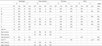


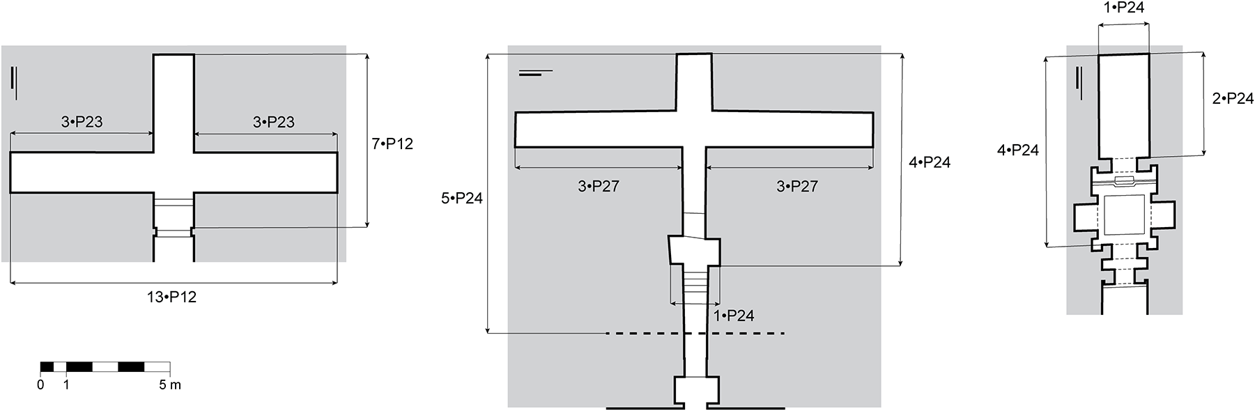


 Open access

