Introduction
Quaternary loess is a widely distributed aeolian deposit that provides fertile agricultural soils as well as detailed climate archives (Pye, Reference Pye1995; Muhs and Bettis, Reference Muhs, Bettis, Chan and Archer2003; Haase et al., Reference Haase, Fink, Haase, Ruske, Pécsi, Richter, Altermann and Jäger2007; Terhorst et al., Reference Terhorst, Thiel, Peticzka, Sprafke, Frechen, Fladerer, Roetzel and Neugebauer-Maresch2011; Lehmkuhl et al., Reference Lehmkuhl, Bösken, Hošek, Sprafke, Marković, Obreht and Hambach2018, Reference Lehmkuhl, Nett, Pötter, Schulte, Sprafke, Jary and Antoine2021; Zeeden et al., Reference Zeeden, Hambach, Obreht, Hao, Abels, Veres, Lehmkuhl, Gavrilov and Marković2018; Li et al., Reference Li, Shi, Aydin, Beroya-Eitner and Gao2020). The most complete loess–paleosol successions are usually located in flat terrain and have been the focus of intensive geological investigations (e.g., Sun et al., Reference Sun, Shaw, An, Cheng and Yue1998; Marković et al., Reference Marković, Hambach, Stevens, Kukla, Heller, McCoy, Oches, Buggle and Zöller2011; Újvári et al., Reference Újvári, Varga, Raucsik and Kovács2014; Sümegi et al., Reference Sümegi, Gulyás, Molnár, Sümegi, Almond, Vandenberghe and Zhou2018; Obreht et al., Reference Obreht, Zeeden, Hambach, Veres, Marković and Lehmkuhl2019; Wacha et al., Reference Wacha, Laag, Grizelj, Tsukamoto, Zeeden, Ivanišević, Rolf, Banak and Frechen2021). Even in some of these cases, it has been shown that the succession is not entirely complete (Varga et al., Reference Varga, Újvári and Raucsik2011; Csonka et al., Reference Csonka, Bradák, Barta, Szeberényi, Novothny, Végh, Süle and Horváth2020; Novothny et al., Reference Novothny, Barta, Végh, Bradák, Surányi and Horváth2020), while the long-term preservation potential of loess outside subsiding basins is especially poor (Meijer and van der Meulen, Reference Meijer and van der Meulen2022).
Areas of higher relief typically possess loess successions with considerable gaps (Steup and Fuchs, Reference Steup and Fuchs2017; Antoine et al., Reference Antoine, Lagroix, Jordanova, Jordanova, Lomax, Fuchs and Debret2019; Lehmkuhl et al., Reference Lehmkuhl, Nett, Pötter, Schulte, Sprafke, Jary and Antoine2021). Like other gaps in stratigraphy, these can be a result of either non-deposition or post-depositional erosion of the accumulated sediment. Non-deposition under otherwise suitable climates may occur if air-flow conditions, such as higher wind speeds, inhibit dust sedimentation over certain parts of elevated topography (e.g., on the windward side or on top of a range). Post-sedimentary erosion of loess is most likely to be controlled by climatic oscillations, where loess accumulated in cold and arid time intervals (glacials/stadials) is removed during the wetter and milder interglacials/interstadials.
In contrast to flatland localities, loess occurrences of more dissected terrains are rarely investigated. Consequently, given the lack of dating results, the timing of stratigraphic gaps and their causative mechanisms are usually unknown. However, this would be important information in some cases. An example is the now widespread method of exposure-age or denudation-rate calculation from in-situ-produced cosmogenic nuclide measurements, where it is necess-ary to have information on previous, by now eroded, sedimentary covers that could have shielded the modern surface from cosmogenic radiation (e.g., Reusser et al., Reference Reusser, Bierman, Pavich, Zen, Larsen and Finkel2004; Ruszkiczay-Rüdiger et al., Reference Ruszkiczay-Rüdiger, Braucher, Á, Csillag, Fodor, Molnár and Madarász2016, Reference Ruszkiczay-Rüdiger, Knudsen, Bauer, Telbisz, Team and Sebe2024). In archaeological studies, looking for the source rocks of lithic tools (e.g., T. Biró, Reference T. Biró1989; Kürthy et al., Reference Kürthy, Szakmány, Józsa and Szabó2013), the accessibility of raw materials can be influenced by the loess cover.
The case presented here investigates a low-elevation mountain range with partial loess cover in the European loess belt. Through Post-Infrared Infrared Stimulated Luminescence-290 (pIRIR-290) dating of the most complete and the typical loess–paleosol outcrops of the area, we identify loess deposition periods in the middle and late Pleistocene, compare the preserved loess packages, and discuss the formation of stratigraphic hiatuses.
Geological setting
Hungary occupies the central part of the Pannonian Basin (sometimes also referred to as the Carpathian Basin), a major back-arc basin of the Alpine orogenic belt in Europe. The topography of Hungary is dominated by lowlands (Fig. 1), while higher elevations are composed of exposed basement blocks and Neogene volcanic edifices, and, with a single exception, their heights do not exceed 1000 m asl. Due to ongoing neotectonic basin inversion, hills and mountains have been uplifting in the past few Ma relative to the subsiding depocenters in the plains (Fodor et al., Reference Fodor, Bada, Csillag, Horváth, Ruszkiczay-Rüdiger, Palotás, Síkhegyi, Timár, Cloetingh and Horváth2005; Bada et al., Reference Bada, Grenerczy, Tóth, Horváth, Stein, Cloetingh, Windhoffer, Fodor, Pinter, Fejes, Stein and Mazzotti2007; Ruszkiczay-Rüdiger et al., Reference Ruszkiczay-Rüdiger, Balázs, Csillag, Drijkoningen and Fodor2020; Porkoláb et al., Reference Porkoláb, Broerse, Kenyeres, Békési, Tóth, Magyar and Wesztergom2023), resulting in erosion of the uplifting areas.
Study sites in the Western Mecsek Mountains. Loess extent from Gyalog and Síkhegyi (Reference Gyalog and Síkhegyi2001).

Loess and its derivatives are the most extensive surface sediment in both lowlands and elevated areas of Hungary (Kercsmár et al., Reference Kercsmár, Budai, Csillag, Kercsmár, Selmeczi and Sztanó2015), covering 30% of the country. Its thickness is extremely variable: in extensive areas it is typically a few meters, its thickness increases in topographic depressions and in subsiding areas, and it can attain nearly 100 m at rare locations (Udvari: Koloszár and Marsi, Reference Koloszár and Marsi2010; Sümegi et al., Reference Sümegi, Gulyás, Molnár, Sümegi, Törőcsik, Almond and Smalley2019; Paks: Novothny et al., Reference Novothny, Barta, Végh, Bradák, Surányi and Horváth2020). The depositional age of loess deposits ranges from ca. 1 Ma to ca. 14–15 ka (Koloszár and Marsi, Reference Koloszár and Marsi2010; Újvári et al., Reference Újvári, Molnár and Páll-Gergely2016; Pazonyi et al., Reference Pazonyi, Virág, Gere, Botfalvai, Sebe, Szentesi, Mészáros, Botka, Gasparik and Korecz2018; Sümegi et al., Reference Sümegi, Gulyás, Molnár, Szilágyi, Sümegi, Törőcsik and Molnár2020; Novothny et al., Reference Novothny, Horváth, Újvári, Babinszki, Piros, Csillag, Fodor, Gyalog, Zs. and Gy.2023). The most complete loess–paleosol successions of the Pannonian Basin: Paks, Stari Slankamen, Mošorin, Batajnica, and Surduk (Marković et al., Reference Marković, Stevens, Kukla, Hambach, Fitzsimmons, Gibbard and Buggle2015, and references therein), are located either along the largest rivers (River Danube and Tisza) or in adjacent areas (e.g., Ruma, Irig, Crvenka; Marković et al., Reference Marković, Stevens, Kukla, Hambach, Fitzsimmons, Gibbard and Buggle2015, and references therein), where sufficient amounts of silt-sized material was always available and abundant from the alluvial plains of these rivers and their tributaries. While these are considered as (more or less) complete records for the entire last 1 Ma, other successions, despite being less thick, could preserve more detailed archives of shorter or longer periods within the last 1 Ma (Mende: Frechen et al., Reference Frechen, Horváth and Gábris1997; Zmajevac: Galović et al., Reference Galović, Frechen, Halamić, Durn and Romić2009; Titel: Bokhorst et al., Reference Bokhorst, Vandenberghe, Sümegi, Łanczont, Gerasimenko, Matviishina, Marković and Frechen2011; Süttő: Novothny et al., Reference Novothny, Frechen, Horváth, Wacha and Rolf2011; Vukovar: Wacha and Frechen, Reference Wacha and Frechen2011; Galović, Reference Galović2016; Wacha et al., Reference Wacha, Laag, Grizelj, Tsukamoto, Zeeden, Ivanišević, Rolf, Banak and Frechen2021). Therefore, they also have great importance in paleoenvironmental and paleoclimate research.
Besides the aforementioned loess sequences, in many hilly or low-mountain areas only a single, few-meters-thick loess layer is preserved. The more complete loess successions contain multiple paleosols of various types, reflecting a cooling tendency of the climate (Frechen et al., Reference Frechen, Horváth and Gábris1997; Novothny et al., Reference Novothny, Horváth, Újvári, Babinszki, Piros, Csillag, Fodor, Gyalog, Zs. and Gy.2023). Tephra layers are important marker horizons in the loess of the Pannonian Basin (Horváth, Reference Horváth2001; Sági et al., Reference Sági, Kiss, Bradák and Harangi2008; Namier et al., Reference Namier, Hao, Gao, Fu, Marković, Hambach and Veres2023). In contrast, paleosols can only be used for reliable correlation with great caution without numerical dating control due to their lateral variations in type and morphology (Novothny et al., Reference Novothny, Barta, Végh, Bradák, Surányi and Horváth2020).
The study area, the western half of the Mecsek Mts, is a typi-cal mountain range of Hungary in the SW part of the country (Fig. 1), with a peak elevation of 602 m and the lowermost valleys and basins lying around 110–120 m asl. The range is built up of Paleozoic, Mesozoic, and Neogene rocks. Loess covers nearly the entire area, except for deeply incised valleys, some of the steep slopes, and the highest mountain tops (Fig. 1). Loess occurs up to elevations around 500 m asl, but it is very patchy and thin there. Loess thickness is variable, with thicker deposits in the western part, where maxima are around 15 m.
Thicker loess successions contain usually one or two paleosol horizons. At their base, the Plio-Pleistocene Mediterranean type paleosol, the Tengelic Red clay Formation, may appear, which has a known age range of 3.5–1 Ma (Csillag et al., Reference Csillag, Sebe, Pazonyi, Babinszki, Piros, Csillag, Fodor, Gyalog, Zs. and Gy.2023). In a small area in the west (near Bükkösd), loess successions up to 40 m thick with as many as four paleosols were documented, but these included loess-derived slope sediments as well (Moldvay, Reference Moldvay1964). At several sites the loess layers bear signs of minor reworking during deposition, showing accumulation on a sloping terrain. Loess-derived slope sediment layers and erosional surfaces in the Quaternary successions show the effects of aquatic (fluvial or areal) erosion. Although effects of Pleistocene wind erosion are not as dominant as in more windward, northern parts of the Pannonian Basin (Sebe et al., Reference Sebe, Csillag, Ruszkiczay-Rüdiger, Fodor, Thamó-Bozsó, Müller and Braucher2011a), ventifacts have been found at several sites within loess profiles in the Mecsek region (Sebe, Reference Sebe2013).
Methods
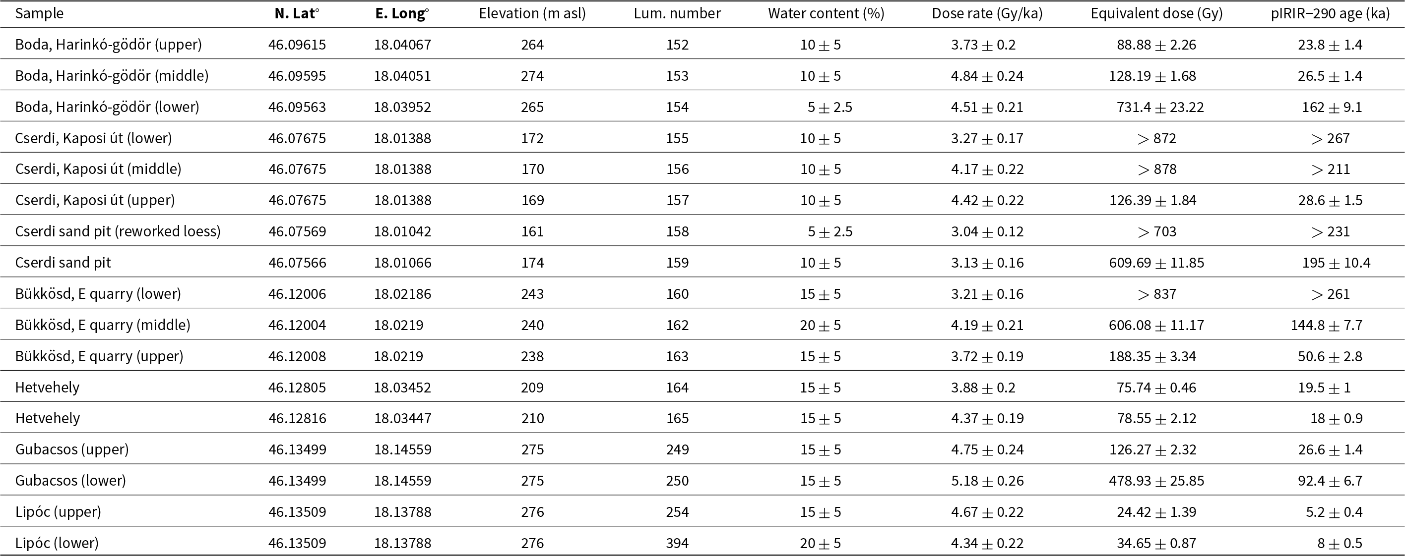
The largest outcrops with the thickest successions, as well as typical, relatively thin loess occurrences, were chosen for sampling (Fig. 1). The thickest sediment packages are located in the western part of the area. In the east the geological map does not indicate loess, but our field experience showed that loess was present, so study sites were selected in this area as well. The chosen outcrops not only represented typical loess occurrences, but also carried information on the surface evolution of the region; for this reason, not only typical loess, but also loess-derived deposits were sampled. The successions were logged and 17 samples were collected for luminescence measurements (Fig. 1, Table 1).
Results of luminescence measurements; Lum. number = the luminescence number given to the sample in the laboratory.

Luminescence measurements
Preparation of the samples was conducted under subdued red light. The polymineral fine grain fraction (4–11 μm) was extracted from the samples. All samples were treated using 0.1 N hydrochloric acid, 0.01 N sodium oxalate, and 30% hydrogen peroxide to remove carbonate, clay coating, and organic matter from the samples, respectively. Polymineral fine grains were separated after Stokes’ law settling and centrifuging in distilled water (Frechen et al., Reference Frechen, Schweitzer and Zander1996; Lang et al., Reference Lang, Lindauer, Kuhn and Wagner1996). Luminescence measurements were performed using an automated Risø TL/OSL-DA-20 reader at the Department of Physical Geography in the Eötvös Loránd University, Institute of Geography and Geology. The reader is equipped with a bialkali EMI 9235QB photomultiplier tube, IR diodes (λ = 875 nm), blue LEDs (λ = 470 nm), and a 90Sr/90Y β-source. A filter package of Schott BG-39 and BG-3, transmitting wavelengths between 350 and 420 nm, was placed in front of the photomultiplier to detect the blue light emission for IRSL measurements.
Equivalent dose determination
Post-Infrared Infrared Stimulated Luminescence-290 (pIRIR-290) protocol was applied for the measurements. The advantage of this method is that the pIRIR-290 signal of feldspar shows negligible fading (Thomsen et al., Reference Thomsen, Jain, Murray, Denby, Roy and Bøtter-Jensen2008; Thiel et al., Reference Thiel, Buylaert, Murray, Terhorst, Hofer, Tsukamoto and Frechen2011; Buylaert et al., Reference Buylaert, Jain, Murray, Thomsen, Thiel and Sohbati2012), therefore fading correction (Huntley and Lamothe, Reference Huntley and Lamothe2001) is not necessary for age determination. This protocol includes an IR stimulation of 200 seconds at 50°C, then an elevated temperature IR stimulation of 200 seconds at 290°C. The latter is used to measure the pIRIR-290 signal for the equivalent dose (De) determination. A preheat of 320°C for 60 seconds was applied prior to the stimulations. At the end of the measurement cycle an IRSL stimulation at 325°C for 100 seconds was performed. The De values were obtained by integrating the first 4.4 seconds of the IRSL decay curve and the final 100 seconds of the stimulation was subtracted to remove the background.
Dose-rate determination
The surrounding sediment was collected from each luminescence position to determine the dose rate of the samples. Dose rates were obtained from the potassium, uranium, and thorium content, as measured by gamma spectrometry in the laboratory at the Eötvös Loránd University, Budapest. An average a-value of 0.08 ± 0.02 (Rees-Jones, Reference Rees-Jones1995) was used for the feldspar IRSL age calculation. A potassium content of 12.5 ± 1% (Huntley and Baril, Reference Huntley and Baril1997) was applied to calculate the dose rate for feldspar to account for the internal dose rate. The cosmic radiation was corrected for altitude and sediment thickness (Prescott and Hutton, Reference Prescott and Hutton1994), assuming water contents of 5–20%, depending on the measured values (Table 1). Dose-rate conversion is based on the factors of Guérin et al. (Reference Guérin, Mercier and Adamiec2011).
Tephra petrography
In one of the outcrops a tephra horizon was identified in the field. Textural and mineralogical identification of the main components of the tephra was carried out by optical microscopic and scanning electron microscopic studies. We prepared thin sections and studied them using a polarizing petrographic microscope. The tephra samples were dried and placed in a vacuum chamber to impregnate them with Araldite epoxy resin. This was followed by careful grinding to obtain thin sections. We did not use a Kubiena box for sampling since the tephra was compacted enough to keep its integrity and allow careful sample preparation. In the Results, we express the relative mineral content in vol %, based on area % estimated during microscopic observations. For the SEM, we used an AMRAY 1830 I/T6 scanning electron microscope (Eötvös Loránd University, Institute of Geography and Earth Sciences, Department of Petrology and Geochemistry) with the following conditions: 20 kV accelerating voltage, 1 nA beam current, and 1 second acquisition time. Mineral phases were checked by semi-quantitative EDS analysis.
Results
Luminescence measurements
The measured concentrations of uranium, thorium, and potassium content in the samples along with cosmic dose rates and total dose rates are summarized in Table 1. Total dose rate values range from 3.04 ± 0.12 Gy/ka to 5.18 ± 0.26 Gy/ka for polymineral fine grains. The pIRIR-290 signal of four of the samples was observed in saturation, therefore only minimum age could be determined for these samples (a single exponential growth curve was fitted to the data points and the 2*D0 value was calculated to assess minimum age estimate). For the other samples normal pIRIR-290 age could be determined. A small residual signal (10–32 Gy) was observed after a 2-day daylight bleaching, which was subtracted from the De value for the age calculation. De values ranged from 24.4 ± 1.4 Gy to 731.4 ± 23.2 Gy (Table 1).
Bükkösd, eastern quarry
The stratigraphically most complete loess–paleosol succession of the Western Mecsek Mountains is exposed at the uppermost level of the large eastern limestone quarry, run by Lafarge, near the village Bükkösd (Fig. 2). This succession overlies a small plateau on the western margin of the mountains. The uneven but still relatively flat surface of the Middle Triassic limestones is covered by a red clay layer, which contains fragments of the underlying limestone, minor amounts of sand, sandstone fragments, quartz pebbles, and Mn/Fe pisoids. This can be assigned to the Tengelic Red clay Formation. On top of this, three loess beds and between them two paleosols could be distinguished (Fig. 3). Above the highest part of the limestone the lowermost loess and paleosol layers are missing. At this location mammoth remains were found between the red clay and the overlying loess layer (Sebe et al., Reference Sebe, Csillag, Szabó, Virág, Gasparik, Novothny, Bosnakoff, Főzy and Szives2021a).
Panoramic view of the succession overlying Triassic limestone in the eastern quarry of Bükkösd. Note that the lowest loess and paleosol layers wedge out towards the right. TR = Tengelic Red clay Formation.

Loess–paleosol successions of the thick outcrops.

The lower loess layer contains abundant carbonate concretions and some krotovinas in its upper part. It provided only a minimum age (>261 ka; Fig. 3), showing it accumulated during MIS 8 or even earlier. Its upper boundary is sharp, with some cracks projecting downward. Because no permafrost features are known from the southern half of the Pannonian Basin (Ruszkiczay-Rüdiger and Kern, Reference Ruszkiczay-Rüdiger and Kern2016), the cracks probably originated from desiccation. This would be in accord with reports of increased aridity during MIS 8 in nearby Serbia and in the north Balkans (Regattieri et al., Reference Regattieri, Zanchetta, Isola, Bajo, Perchiazzi, Drysdale, Boschi, Hellstrom, Francke and Wagner2018; Radaković et al., Reference Radaković, Gavrilović, Gavrilov, Marković, Hao, Schaetzl and Zeeden2024).
The overlying paleosol is dark brown, with a gradual transition towards the next loess layer. The second loess layer is typical loess with shells of loess snails, in its upper half meter with a few faint horizontal boundaries indicating minor areal reworking (e.g., sheet wash). This layer dates to late MIS 6 (144.8 ± 7.7 ka). The upper paleosol is dark brown, crumbly, and both of its boundaries are transitional. The uppermost loess does not represent the last glaciation; instead, its luminescence age of 50.6 ± 2.8 ka falls into the relatively mild interval preceding the last glaciation (early MIS 3).
Boda, Harinkó-gödör
A deep gully NW of the village Boda hosts the thickest loess–paleosol outcrop of the area, with two layers of both sediment types (Figs. 3, 4). Although the exposed thickness of the loess succession is less than 10 meters here, it is still considerably thicker than in the immediate surroundings, on the south slope of the range, where only thin loess covers the bedrock. A reason for the preservation of relatively thick loess could be the orientation of the gully perpendicular to the prevailing northerly winds in the Pleistocene (Sebe et al., Reference Sebe, Csillag, Ruszkiczay-Rüdiger, Fodor, Thamó-Bozsó, Müller and Braucher2011a), which created a sediment trap from the gully. A similar situation has been documented in NW Hungary (Sebe et al., Reference Sebe, Csillag and Thamóné Bozsó2011b). Some resedimentation from the slopes also might have contributed to loess thickness, although the only signs of this are scattered small soil fragments.
The outcrop of the Harinkó-gödör near Boda. The sample that provided age for the upper loess layer was taken more to the NE, out of the photographed section.
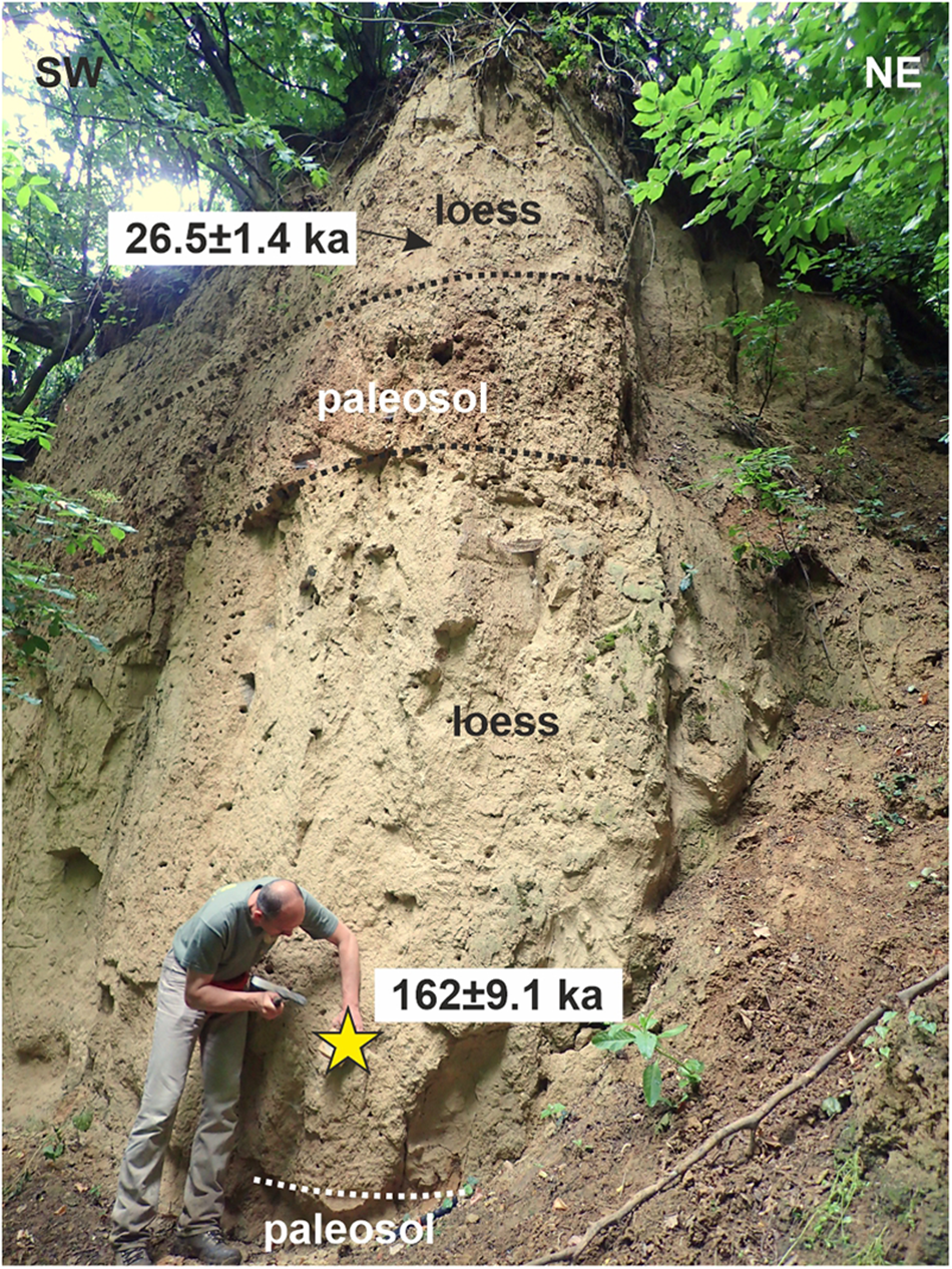
The contact of the loess succession and the underlying bedrock, the Permian Boda Claystone Formation, is not exposed. The first Quaternary layer, the lower paleosol, is represented by only small outcrops of its uppermost part. It is brownish red silty clay, and shows a gradual transition into the overlying, lower loess layer. Luminescence age determination (162 ± 9.1 ka) indicates that the lower loess unit, with carbonate concretions and gastropod shells, accumulated mostly during the second half of MIS 6 glacial. The upper, again brownish red, paleosol is thick and well developed, with a strong carbonate accumulation horizon. Based on this appearance the soil very likely developed during MIS 5, although, because of the age of the overlying loess, some contribution from MIS 3 cannot be excluded. The loess above it represents the last glacial maximum (LGM) according to the luminescence measurements (26.5 ± 1.4 ka, 23.8 ± 1.4 ka).
The dip of the paleosols is only slightly less than the present-day dip of the gully hosting the loess succession. Thus, a topography similar to the modern one can be supposed for the region at the time(s) of pedogenesis, with slopes dipping towards the present-day main valley. The thick succession preserved here in the gully suggests that in cold-climate intervals loess could have accumulated on the surrounding terrains as well, but it could have been eroded off during the next mild and humid period.
Cserdi, Kaposi út (Kapos road), road cut
A deeply incised E–W oriented old road track east of the village of Cserdi exposes three loess units, two paleosols, and a tephra layer (Figs. 3, 5). Below the lower paleosol, the loess contains abundant carbonate concretions. The yellow, maximum of a few centimeters thick tephra forms a sharp horizon in the outcrop appearing as a deep groove because of its low hardness (Fig. 5). The layer is not continuous, it is missing for some distance at several locations. Its inner structure is weakly laminated. It has an apparent dip of 8–10° towards the west, the margin of the mountains. Upslope, towards the east, it wedges out because it has been eroded. At roughly the same elevation other units thin out as well: the two paleosols merge here, while the loess unit between them wedges out. This refers to a paleotopography similar to the modern one since at least the deposition of the tephra, with a west-dipping slope. It also points to erosion or non-deposition on hilltops contemporaneous with accumulation on the slopes. Luminescence age determinations place the age of the uppermost loess layer to around the last glacial maximum.
(A) The outcrop of the Cserdi road cut with a tephra layer (arrow). (B, C) Close-up of the tephra among carbonate concretions.

The tephra was reported from this site in 1955 by Gertig as ‘ochre-coloured sand,’ although he did not recognize its volcanic origin. However, its characteristic yellowish brown color helps its recognition and correlation to other occurrences in the Pannonian Basin (Horváth, Reference Horváth2001). Microscopic studies clearly proved that this bed has a volcanic origin and, because no active volcanoes capable of large explosive eruption are known in the Pannonian Basin at this time, it must be a distal tephra derived from an eruptive event outside the Carpathian–Pannonian area. It contains 20–80 mm sized cuspate glass shards with circular vesicles and pumiceous glass shards, occasionally containing tiny microlites, presumably clinopyroxenes (Figs. 6 and 7). The glass is usually thoroughly altered, which is similar to glass found in most of the tephra layers in Hungary (Sági et al., Reference Sági, Kiss, Bradák and Harangi2008). Solitary crystals of elongated green clinopyroxene, K-feldspar, feldspathoids, probably leucite and/or sodalite, and biotite are frequent in the groundmass. The juvenile components are mostly glass shards (90–95 volume %), whereas clinopyroxene is the dominant crystal phase (4–8 volume %) in addition to the K-feldspar (∼1%), plagioclase and feldspathoids (< 1 volume %), Ti-magnetite (< 1 volume %), and apatite (≪ 1 volume %). Lithic clasts containing feldspar microlites also are found occasionally. Clinopyroxenes have variable compositions, particularly in Ti and Al, and resemble those found in the Bag Tephra in Hungary (Sági et al., Reference Sági, Kiss, Bradák and Harangi2008). K-feldspars containing significant amounts of Ba and minor amounts of Na-rich plagioclase were also found. The latter has an importance since the Villa Senni eruption products, which are thought to correlate with the Bag Tephra (Pouclet et al., Reference Pouclet, Horváth, Gábris and Juvigné1999), do not contain plagioclase, only feldspathoids. On the other hand, clinopyroxene composition clearly suggests a strongly alkaline host magma similar to those found in central Italy. The juvenile fragments are mixed with crystal fragments (e.g., quartz, muscovite, calcite) from the host loess, although mixing is limited and the tephra preserved its coherence, suggesting fast deposition and burial.
Optical microscope and scanning electron microscope pictures of the tephra deposit. Note the distinct types of reddish-brown and bright brown vesicular glass shards, which occasionally contain elongated clinopyroxene laths (A, B). Euhedral phenocrysts, presumably leucite, occur occasionally in the pumiceous glass shards (C). The back-scattered image (D) presents the coherent tephra layer with blobs of loess material (outlined by red lines). KT is a volcanic lithoclast containing clinopyroxene and plagioclase microlites. Glass shards (denoted as 1–3) are thoroughly altered.

Back-scattered electron images of the tephra. (A) Distinct glass types are denoted by 1–3. Nontronite (non) occasionally fills the vesicles. Clinopyroxene (cpx) and K-feldspar (kfp) are the most frequent juvenile mineral phases mixed with lesser amounts of loess-derived quartz and muscovite grains. (B) Intergrowth of plagioclase (pl), clinopyroxene (cpx), and apatite (ap) with attached altered glassy material; chl = chloritic clast from the loess; gl = volcanic glass (slightly altered); gl* = volcanic glass (strongly altered).

Based on stratigraphic position and petrographic features, the tephra layer can be correlated with the Bag Tephra, which is a regionally well-preserved tephra layer in the loess in Hungary (Pouclet et al., Reference Pouclet, Horváth, Gábris and Juvigné1999; Horváth, Reference Horváth2001; Sági et al., Reference Sági, Kiss, Bradák and Harangi2008; Marković et al., Reference Marković, Stevens, Kukla, Hambach, Fitzsimmons, Gibbard and Buggle2015). Samples for luminescence measurements directly underlying and overlying the tephra were saturated and provided only minimum ages (>211 ka and >267 ka; Fig. 3). Based on the major and trace element composition of the only fresh glass shards from the tephra bed near Pásztó, Pouclet et al. (Reference Pouclet, Horváth, Gábris and Juvigné1999) and Horváth (Reference Horváth2001) suggested that this tephra derived from the 330–340 ka Villa Senni eruption in the Colli Albani volcano. However, Sági et al. (Reference Sági, Kiss, Bradák and Harangi2008) questioned whether these tephra beds have the same origin and put forward the possibility that they could have derived from at least two distinct eruption events based on the clinopyroxene compositional signature. This is consistent with the malacological investigations by Hum (Reference Hum2005), who also proposed at least two volcanic events, although without any specific age, based on the fact that the mollusk assemblages of the loess layers containing the tuff horizon indicated different climates at different studied locations in the SW Pannonian Basin. Detailed magnetostratigraphic investigations in Serbia revealed the presence of at least three tephra horizons, with ages of ca. 160 ka, ca. 370 ka, and ca. 457 ka, with the latter two originating from Central Italian volcanic eruptions (Laag et al., Reference Laag, Hambach, Zeeden, Lagroix, Guyodo, Veres, Jovanović and Marković2021; Namier et al., Reference Namier, Hao, Gao, Fu, Marković, Hambach and Veres2023). In any case, further study is necessary to refine the origin of the Quaternary tephra beds in Hungary.
Cserdi, sand pit
West of the previous outcrop, an abandoned sand pit exposed further remnants of the paleotopography, where (Pliocene through) Quaternary deposits are preserved over Upper Miocene limonitic, gravelly sands (Fig. 8). The surface of the sands is rugged, reddish, and underwent pedogenesis. This paleosol horizon can be correlated with the Late Pliocene–Early Pleistocene Tengelic Red clay. This formation is also exposed in a well-developed profile in another sand pit 900 m northwest of here.
The loess-derived Quaternary valley fill and the loess cover of the Cserdi sand pit. Photo taken in 2012.

The steepest portions of the paleosurface are draped with thin slope sediments derived from the limonitic sands. The overlying deposit fills a 7- to 8-m-deep paleovalley (Pirkhoffer, Reference Pirkhoffer1998). It is thin bedded, carbonate cemented, with parallel, roughly horizontal beds that have frequently changing grain sizes and often wedge out laterally. This structure suggests deposition by areal wash (sheet flow). The lower part of the valley fill is composed of the reworked material of Upper Miocene gravelly sands, both in their original form and with a pedogenic overprint. The upper part contains significant amounts of yellowish-brown silt, which must have originated from loess, given the sand- and hard-rock-dominated character of pre-Quaternary formations of the area. Abundant reworked carbonate concretions in this part may also have been derived from loess. The eroded surface of the valley fill and the Upper Miocene sands, which is parallel with the modern surface, dips towards the present-day main valley in the west and is covered with gastropod-bearing loess.
The obtained luminescence age of the upper loess sample (195.0 ± 10.4 ka) shows that at around 200 ka ago, the topography was similar to the present-day one, sloping towards the west, so the modern main valley already existed at that time. The age determination of the loess-bearing valley fill provided a minimum age of 231 ka. Its theoretical maximum age is the start of loess deposition, dated to ca. 1 Ma in Hungary (Koloszár and Marsi, Reference Koloszár and Marsi2010; Pazonyi et al., Reference Pazonyi, Virág, Gere, Botfalvai, Sebe, Szentesi, Mészáros, Botka, Gasparik and Korecz2018; Novothny et al., Reference Novothny, Horváth, Újvári, Babinszki, Piros, Csillag, Fodor, Gyalog, Zs. and Gy.2023). Reworked loess appears in the valley fill at as elevation of ∼146 m asl. It is not possible to decide whether the paleovalley was analogous with the modern, NNE–SSW trending main valley of the area, or was a side valley, but it is obvious that at the time of deposition, the main valley cannot have been at an elevation higher than 146 m asl. Presently it lies at 138 m asl. The difference between the past and modern elevations is 8 m, which represents the maximum incision until the present day (i.e., how much the valley has lowered), most probably as a result of the slow uplift of the area. The possible age range of the valley fill (1 Ma to 231 ka) gives the limits of the time interval available for incision. The ratios of these two parameters give a maximum incision rate of 0.008–0.035 mm/yr (8–35 m/Ma) for the later Quaternary of the area.
Hetvehely
The northernmost sampled outcrop is a loess occurrence typical for the western part of the area: a few meters thick, deposited on a somewhat sloping terrain (Fig. 9). At the bottom of the small, valley-side loess pit, a paleosol is exposed. The loess here contains some gravel seams composed of angular dolomite pebbles derived from the Triassic basement in the immediate surroundings of the outcrop. The gravel seams, representatives of the paleotopography, dip towards the modern watercourse and can be followed down-slope almost until the modern alluvium. Based on the OSL ages (19.5 ± 1.0 ka and 18.0 ± 0.9 ka), loess deposition took place during the last glacial, and the coeval valley morphology practically corresponded to the modern one.
Loess outcrop SW of Hetvehely, with inclined gravel seams sloping towards the watercourse (Bükkösdi-víz).

Gubacsos
This outcrop is a gully side on the floor of a dry valley in the NE, karstified part of the area, next to the Gubacsos Cave opening at the bottom of a sinkhole (Fig. 10). There is no watercourse in this valley segment, only short gullies drain rainwater into sinkholes. Quaternary sediments in this area, which are thickest on valley floors, in dolines, or in sinkholes, reach a maximum thickness of 1.5–2 meters at the toe of slopes, and thin out upslope. This outcrop exposes not only loess but also underlying sediments: well-rounded medium to coarse gravel above the Middle Triassic limestone basement and sandy, clayey silt produced by reworking and weathering of loess and the gravel.
Outcrop near the entrance of Gubacsos Cave.

The gravel clast material is partly local carbonates and partly Lower Triassic sandstones with a distal provenance. This, together with the rounding and coarse grain size, suggests the interpretation of the lowermost layer as a lag gravel of a watercourse that has disappeared. The massive, medium-sorted second layer must have been deposited rather by sheet wash than by a watercourse, during the relatively mild climatic interval of MIS5 after the last interglacial (92.4 ± 6.7 ka). This hypothesis is supported by the luminescence properties of this sample, as this was the only sample that had a wider dose distribution among its sub-samples, indicating that the bleaching might not have been total for some of the sub-samples. However, its larger errors associated with the dose and age very likely cover the real deposition time of the sample. Loess deposition took place during the LGM (26.6 ± 1.4 ka), already in a dry valley.
Lipóc
A closed group of coalesced dolines stores ∼5-m-thick Quaternary sediments, silt and some fine-grained sand, from the flat bottom of the depression to the Middle Triassic limestone exposed in a sinkhole at the deepest point (Fig. 11). The upper ∼2 meters show horizontal bedding, the lower part is mostly massive silt with a few thin interbeds of fine sand. The lower parts of the surrounding slopes are covered with loess. OSL measurements (8.0 ± 0.5 ka and 5.2 ± 0.4 ka) revealed that even the lower, massive portion of the silty succession was deposited in the Holocene. Therefore, this site does not help to constrain Pleistocene loess deposition periods, instead it shows intense reworking of loess during the Holocene.
Quaternary (Holocene), mostly loess-derived sediments in the Lipóc doline system.

Discussion
Chronology of loess deposition
The results of the OSL measurements, together with the climatic curve and the most complete loess–paleosol record of the region (Paks brickyard) are displayed graphically in Figure 12. Preserved loess successions are obviously temporally fragmentary: they contain a much lower number of loess and paleosol units than the most complete successions—Paks brickyard and boreholes, Udvari-2 borehole—located in low hilly areas at elevations around 150–200 m asl (Koloszár and Marsi, Reference Koloszár and Marsi2010; Sümegi et al., Reference Sümegi, Gulyás, Molnár, Sümegi, Almond, Vandenberghe and Zhou2018; Novothny et al., Reference Novothny, Barta, Végh, Bradák, Surányi and Horváth2020; Fig. 1). The preserved units do not uniformly represent the last or last few climatic periods, instead, they are scattered across the measurable age range. Age determinations showed that there are gaps even in successions where the boundary between the layers seems to be transitional and not sharp (erosional) in the field (e.g., Cserdi, Kapos road cut).
Dating results of loess–paleosol successions. Blue bars indicate certainly identified periods of loess deposition. Isotope curve after Lisiecki and Raymo (Reference Lisiecki and Raymo2005), magnetostratigraphy after Channell et al. (Reference Channell, Hodell and Curtis2016), the Paks loess succession after Novothny et al. (Reference Novothny, Horváth, Újvári, Babinszki, Piros, Csillag, Fodor, Gyalog, Zs. and Gy.2023). PDB = Pee Dee belemnite.

The most recent loess accumulation period, supported by numerous age dates, is the last stadial (MIS 2), mostly the LGM (22.1 ± 4.3 ka; Shakun and Carlson, Reference Shakun and Carlson2010). The measured age data range between ca. 18 ka and 29 ka (Fig. 12). The presence of the youngest dust deposition was proved in all but one locations. The youngest ages are several thousand years older than the known end of loess deposition in Hungary, meaning that at the end of the Pleistocene loess did not accumulate or was eroded after deposition.
The next numerical age, ca. 51 ka, of the sample of the Bükkösd quarry suggests loess deposition for MIS 3. This was a relatively mild period not just in the general climate curve (Fig. 12) but also for the study area (e.g., for two fossil sites nearby, vertebrate paleontological studies indicated scattered arboreal vegetation, and a positive thermal gradient compared to the mammoth steppes in the northern Pannonian Basin; Sebe et al., Reference Sebe, Szentesi, Pazonyi, Surányi and Csillag2021b). Nevertheless, the vertebrate remains were recovered from (redeposited but probably coeval) loess, showing that loess accumulation was still active in spite of the warming. High mass accumulation rates were reported for MIS 3 from the southern part of the Pannonian Basin, from Nosak and Kisiljevo (Perić et al., Reference Perić, Marković, Sipos, Gavrilov, Thiel, Zeeden and Murray2020, Reference Perić, Marković, Avram, Timar-Gabor, Zeeden, Nett, Fischer, Fitzsimmons and Gavrilov2022a, Reference Perić, Stevens, Obreht, Hambach, Lehmkuhl and Marković2022b, Reference Perić, Ryan, Alexanderson and Marković2024). Based on these results it is very likely that dust deposition could have been intensive, at least in some parts of the Pannonian Basin, even during this milder interstadial. Although no age data fall into MIS 4, that period was colder than MIS 3, it seems therefore logical to suppose loess formation for this interval as well.
Three age dates that represent MIS 6 are distributed over the span of the interval. The age from the Bükkösd quarry (ca. 145 ka) falls at the end of MIS 6. The thickness of the preserved loess from MIS 6 is remarkable at two locations (Bükkösd and Boda), especially if we consider that 3–4 m of loess deposited during only the second half of that glacial. It is tempting to suppose that the overlying paleosol at Bükkösd is the product of the next interglacial, MIS 5e, and the loess unit above it covers the time span from the younger, colder parts of MIS 5 to the dated MIS 3. However, the uppermost loess layer is relatively thin compared to the thickness that could have accumulated during this time considering the several meters per kiloyear deposition rates of more complete successions (Újvári et al., Reference Újvári, Kovács, Varga, Raucsik and Marković2010, Reference Újvári, Stevens, Molnár, Demény, Lambert, Varga, Jull, Páll-Gergely, Buylaert and Kovács2017; Novothny et al., Reference Novothny, Barta, Végh, Bradák, Surányi and Horváth2020; Perić et al., Reference Perić, Stevens, Obreht, Hambach, Lehmkuhl and Marković2022b).
The oldest identifiable numerical age was 195 ± 10.4 ka; beyond this, only minimum ages were obtained. Minimum ages around 260 ka indicate that the start of loess deposition is at least MIS 8 or older. Stratigraphic correlation allows the identification of even older time intervals. The tephra horizon in the Cserdi outcrop corresponds to the Bag Tephra, estimated to be 330–340 ka (Horváth, Reference Horváth2001) or ca. 368 ka old (Namier et al., Reference Namier, Hao, Gao, Fu, Marković, Hambach and Veres2023, and references therein), therefore the tephra-bearing loess unit accumulated during MIS 10. Considering that the measurement of very fragmentary successions revealed loess deposition in nearly all time intervals with suitable climate within the range of the dating method, there is no reason to suppose that loess formation was absent beyond the luminescence dating limit.
Preservation of loess
The spatial distribution of preserved loess is not uniform. The longest successions are located in the eastern part of the area, which lie at lower elevations (150–300 m asl). These successions provided the oldest ages as well. However, the temporal gaps are not systematically distributed in these outcrops (i.e., there is no tendency in the gaps to get longer in any direction, such as towards the higher elevations or towards the margin of the mountains). Actually, the gaps are not even roughly coeval in the neighboring successions, showing that periods with areally extensive non-deposition should not be assumed. It seems more realistic that loess covered the entire area during cool and cold intervals, and was eroded afterwards with intensities changing in time and space.
Erosion of previously deposited loess in various parts of the Pleistocene is attested by the >231 ka and 92.4 ± 6.7 ka loess-derived sediments of the Cserdi and Gubacsos sites, respectively. The thick reworked loess package at the Lipóc site, which dated to ca. 8–5 ka, also supports the option of erosion versus non-deposition. If the uppermost, youngest portion of the late Pleistocene loess was eroded during the earlier part of the Holocene, this explains why the last few thousands of years to few tens of thousands of years before the known end of loess deposition in Hungary, preserved in the more complete successions (e.g., around Paks), are not captured with the chronological data obtained in the Mecsek Mountains.
Eroded loess can enter the drainage network, as shown by the oldest layers of the Cserdi sand pit and Gubacsos sites and by the modern watercourses, where the alluvium is often dominantly built up of reworked loess. However, the Gubacsos and Lipóc sites, together with hundreds of additional sinkholes, testify that where the basement is composed of carbonate rocks, the karst is a further important sink, or at least temporary storage, for the loess.
Evolution history of the area
Several loess outcrops provide information on geomorphic evolution. Small gullies perpendicular to prevailing winds and closed depressions could have acted as sediment traps (Boda, Lipóc), creating a less-dissected topography. Subduing effect of loess on topography is also visible in Bükkösd, the Cserdi road cut, and at the Gubacsos site. In most of the study area the dip of paleo-sols and gravel seams (Boda, Cserdi, Hetvehely, Bükkösd) points to a paleotopography similar to the modern one since at least 260 ka. In contrast with the rest of the outcrops, the Gubacsos profile indicates a profound change in surface hydrology, where a high-energy paleo-watercourse disappeared, and the site turned into a dry valley some time before 92 ka.
The incision rates of watercourses have been modest, maximum 0.008–0.035 mm/yr (8–35 m/Ma) for the past few hundred thousand years. Incision is most easily explained with slow uplift of the mountains. A maximum uplift rate of 0.05 mm/yr (50 m/Ma) has been reported for the past 400 ka from the nearby Villány Hills, which is 30 km to the south (Szujó et al., Reference Szujó, Sebe, Sipos and Pozsgai2017). In the Transdanubian Range, ∼100 km to the north, the long-term uplift rate for the past 3 Ma has been calculated to be ∼0.05 mm/yr (50 m/Ma), while the apparently accelerated (200 m/Ma) incision of the river Danube in the last 140 ka was explained with climate-driven surface processes in addition to geodynamic factors (Ruszkiczay-Rüdiger et al., Reference Ruszkiczay-Rüdiger, Balázs, Csillag, Drijkoningen and Fodor2020). Thus, the incision rate in our study area can refer to a bedrock uplift rate at a simi-lar order of magnitude as in areas north or south of it but with a somewhat slower pace. If valley incision in the western Mecsek Mountains is not only a reflection of uplift, but partly or entirely of the more humid and thus more erosive Holocene climate, then the uplift rate could be even lower than this maximum value.
Conclusions
Seven outcrops of loess–paleosol successions were logged and dated with the luminescence method in order to trace loess cover during the Pleistocene in a low-elevation mountainous area in SW Hungary. Field observations show that the exposed successions attain a maximum thickness of 15 m. The exposed successions are fragmentary, contain few loess layers and few, if any, paleosols compared to the more complete profiles of lower elevations (e.g., Paks, Udvari). The maximum thickness of a loess unit is ∼4 m, while it exceeds 10 m in lowland successions. Loess is thicker in the western part of the study area, thinner in the (north)east, and is missing on the highest mountain tops. A new occurrence of well-preserved Quaternary tephra was documented in one of the loess layers. Based on its stratigraphic position and petrographic features, such as glass shard type and mineral assemblage, the tephra can be correlated with the middle Pleistocene Bag Tephra, which is a widespread marker horizon in the Pannonian Basin.
Luminescence dating results together with stratigraphic correlation provided age constraints on periods of loess formation. Although dates from around the LGM are most abundant, the preserved units do not only represent the last or last few climatic periods, but they also are scattered across the measurable age range. The oldest identifiable numerical age was nearly 200 ka; beyond this, only minimum ages were obtained. The presence of the tephra layer extends the start of loess deposition at least to MIS 10. The youngest ages were ca. 18 ka, thousands of years older than the known end of loess deposition in Hungary. While in most outcrops the uppermost loess unit accumulated during the last cold-climate interval (MIS 2), this is not a rule: at one site the youngest loess had a MIS 3 age (ca. 50 ka). This also showed that loess accumulation was active even in this relatively mild time interval. The dating of loess successions provided valuable data on the geomorphic evolution of the study area as well.
Results suggest that loess was deposited in all climatically suitable periods within the limits of the dating methods, and probably also preceding this limit. The relatively low thickness of loess–paleosol successions as well as of individual loess units, together with the low number of preserved layers, must have been a consequence of repeated erosion during the Pleistocene, especially in the highest regions and those most exposed to the prevailing northerly winds, rather than of non-deposition. Thus, the mountains probably have been covered with loess for most of the time during the past 1 Ma. This should be taken into consideration in all studies influenced by the loess cover of an area, from the dating method using in situ produced cosmogenic nuclides to archaeological studies.
Acknowledgments
Work was solicited by PURAM (Public Limited Company for Radioactive Waste Management). We are grateful to Zsolt Várbíró and Áron Csomor (Lafarge Ltd.) and István Csendes (Bükkösdkő Ltd.) for supporting our work in the Bükkösd quarries, and Márton Bauer, Ádám Kovács and Zsófia Ruszkiczay-Rüdiger for help in field work and for discussions. Á. Novothny is thankful to the Hungarian NRDIO 135509 research project. The comments of two anonymous reviewers helped to improve the manuscript. This is HUN-REN-MTM-ELTE Paleo contribution No. 413.
Conflict of interest statement
The authors state that they have no conflict of interest to declare.