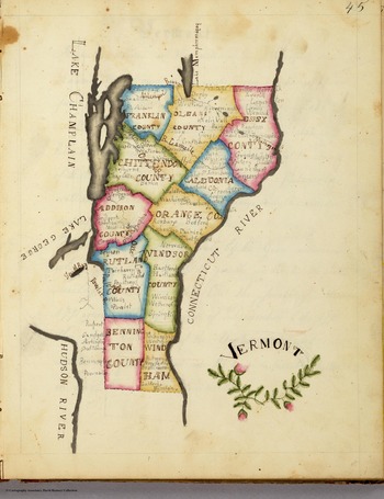


Like many of his fellow students in American schools in the first half of the nineteenth century, Robert Breckenridge (1828–1887) spent untold hours in 1847 drawing, redrawing, inking, and coloring maps of his nation. Two of his surviving maps record land divided by parishes painted in red, green, blue, yellow, and purple, with major geographic landmarks carefully inscribed, all neatly bisected by lines of latitude and longitude. More than the result of duplication, the Breckenridge maps were the product of a sophisticated geographic pedagogy intended to cultivate national sentiment in children of the new American republic through the repeated drawing and redrawing of maps, until they could be recalled solely from memory. This pedagogical theory posited that by hand drawing maps, budding patriots crafted mental landscapes that enabled them to distinguish between self and other, local and foreign. Susan Schulten, Martin Brückner, and Bethany Nowviskie have previously drawn our attention to the unique place that map drawing, stitching, and painting had in crafting national sensibilities in the early American republic by highlighting the work of young student mapmakers such as Catharine Cook, Harriet Baker, and Frances Henshaw (see Figure 1).Footnote 1
Frances Henshaw, “Vermont,” 1823, 23 × 18 cm. (Map courtesy of David Rumsey Map Collection, www.davidrumsey.com.)

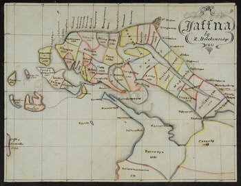
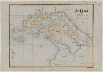
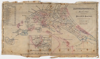
What distinguishes Breckenridge's pair of maps is not his method—his work shares a family resemblance with the efforts of many students of the period—but rather his subject matter. The Breckenridge maps do not depict Massachusetts, Vermont, or any other part of the United States, nor do they represent a faraway continent or the entire globe, all frequent subjects of American school hand-drawn and stitched maps of the period. Instead of the state and country boundaries most Americans would recognize, the nation Breckenridge repeatedly drew and painted was a Tamil nation, graphically represented by the Jaffna Peninsula, a strip of land at the northernmost reach of Ceylon (now Sri Lanka) that skirts India's southern coast (see Figures 2 and 3). “Robert Breckenridge” was the name given to Ampalam KatiramanFootnote 2 upon his arrival at the American Ceylon Mission's (ACM) Batticotta Seminary in 1838.Footnote 3
Robert Breckenridge, “Jaffna,” 1847, 20 × 26 cm. (Map courtesy of Mount Holyoke College Archives and Special Collections.)

Robert Breckenridge, “Jaffna,” ca. 1847, 20 × 26 cm. (Map courtesy of Beinecke Book and Manuscript Library, Yale University.)

That the Breckenridge maps exist at all raises a number of questions significant to the history of education. How did a self-consciously American pedagogy of geography end up on the opposite side of the globe before 1850? What knowledge was the teaching method intended to impart and how did it relate to its purpose back in America? Further, what was the result of this way of teaching on dominant Tamil portrayals of space and self in Ceylon? In order to answer these questions, this essay draws on the Breckenridge maps to track one aspect of the underexplored influence of American didactic mapmaking by locating the linked colonial, imperial, and evangelical purposes that facilitated its travel from New England to South Asia. Following in the footsteps of Sumathi Ramaswamy's recent magisterial argument about the globe as an agent of colonial modernity in India, I argue that importing a map-drawing pedagogy into Jaffna partially transmitted American ways of thinking and being in the world and had consequences for preexisting spatial knowledges and the crafting of a peninsula-specific Tamil national identity.Footnote 4
Due to Sri Lanka's recent civil war (1983–2009) and the inaccessibility of archival resources, Jaffna has been an inconsistent part of several historiographies connecting South Asia, colonialism, and education. While rectifying this issue is well beyond the scope of any one paper, I seek to bring the ACM to the attention of historians of education, as the extensive documentation the mission left behind provides a rich resource for scholars interested in early examples of Americans embracing John Winthrop's “city on a hill” sermon as an imperative of exceptionalism and imperial purpose.Footnote 5 Much of the ACM's education work was conducted simultaneously with the United States government's forced assimilation of Indigenous populations through education during its territorial expansion, and a good deal prior to the acquisition of colonial possessions in the Philippines, Cuba, and Puerto Rico. Up until a major restructuring of the mission in 1855, the ACM drew a disproportionate amount of funding and American public attention compared to the dozens of missions managed by its parent organization, the American Board of Commissioners of Foreign Missions (ABCFM). This prestige was rivaled only by its sister mission in Ha waiʻi, known to the American public as the Sandwich Islands.
Through the use of Jaffna's preexisting physical infrastructure (including Portuguese- and Dutch-built churches) and a network of village schoolmasters willing to teach American lessons for a salary, by 1836 the ACM was supervising the education of 6,661 students in a space roughly the size of New York City's five boroughs. For comparison, this is nearly five times the number of Indigenous students educated the same year in the United States by the Office of Indian Affairs.Footnote 6 This bustling school network was funded in part through a scholarship scheme that enabled American churches, individuals, and social committees like the Female Mite Society of Baltimore, Maryland, and the Ladies Association of Salem, Massachusetts, to sponsor a child's annual living and educational expenses for a $20 donation. In exchange, the sponsor would designate a scholarship name for the child (e.g., Robert Breckenridge) and receive recognition for the donation in published reports of the ABCFM. Between 1817 and 1837, 98 percent of the $44,916 donated for the ABCFM's overseas educational activities was sent to Jaffna.Footnote 7
This educational abundance dramatically transformed life in Jaffna in ways that are still unfolding. Perhaps the most visible effect of the ACM's education system in Jaffna was the creation of a class of highly trained young men and women who were quickly integrated into the British colonial state via white-collar positions across the eastern reach of the British Empire, first as translators and teachers, then as superintendents and administrators.Footnote 8
By the latter part of the nineteenth century, Jaffna's educational infrastructure (a combination of ACM, British, and Catholic missionary schools as well as Ceylonese-led institutions) was so robust that education became known as the peninsula's principal social and economic contribution to the island. This sophisticated educational apparatus supported the peninsula's high level of literacy and bolstered British claims that Ceylon was a model colony and the jewel of the empire, assertions that formed part of the rhetorical justification of colonial rule.Footnote 9 Following Ceylonese independence in 1948, politicians from the ethnic majority Sinhala community argued that the larger Ceylonese colonial education system—of which the ACM was a core component—had disproportionately given educational opportunity to Tamils over the Sinhala. Between 1956 and 1972, this argument was consistently used to justify anti-Tamil legislative acts, which were later cited as among the political causes of the island's civil war. In other words, while American missionary education did not cause the civil war in Sri Lanka, the ACM's history as a projector of American values and identity cannot be entirely disconnected from the rise of post-colonial nationalisms that have fractured the island.
Since the 1990s, tremendous energy has been expended trying to disentangle the causes of the war. Most scholarship points to the breakdown of the political process in the early and middle parts of the twentieth century.Footnote 10 Scholars of Ceylonese or Sri Lankan Tamil nationalism often describe that nationalism as a twentieth-century project, a reaction to or arising in the context of the majority nationalism of the island's Sinhala community.Footnote 11 The rise of a Ceylon-specific Tamil national sensibility has also been linked to a Jaffna-based Hindu revival beginning in the 1840s, which has been framed as a Hindu reaction to Christian evangelism.Footnote 12 This paper identifies mid-nineteenth-century missionary activity as a contributing factor to a Jaffna-specific Tamil nationalism through a colonizing process that Ramaswamy has described as “pedagogical modernity,” or the disciplined cultivation of learning intrinsic to the production of the educated modern citizen.Footnote 13
For a historiographical debate over the birth of Tamil nationalism in Ceylon, new insights into the history of American education offer intriguing paths for understanding how nationalism, colonialism, and education intersected in the island's past. Brückner has convincingly argued that geographic education in the decades following the American Revolution contributed to the crafting of the new country's national identity.Footnote 14 In a series of works, Schulten has carefully considered the degree to which American national identity was predicated on geographic knowledge, noting how visualization worked to justify the state. “Geographic knowledge,” she tells us, “framed the country as territorially coherent—even destined.”Footnote 15 Schulten's recent investigation of student map drawing between the 1790s and the 1830s details how a geographic pedagogy that relied on map drawing encouraged students to “inhabit the national community, a step beyond the passive seeing of a map toward a more active declaration of membership—albeit constricted—in the national body [emphasis in original].”Footnote 16 Recent research by Clif Stratton has also drawn attention to the role that colonialism and imperialism played in late nineteenth-century American public education by highlighting the significance of didactic geography as a tool by which “new ‘scientific’ and ‘objective’ narratives of American history heralded the United States and its European American population as an exceptional nation and people in ways that reinforced the divisions of race and civilization taught in world geography.”Footnote 17 This paper demonstrates how Breckenridge's maps are indicative of a larger, early and mid-nineteenth-century project of “cartographic evangelism”—to borrow once more from Ramaswamy—that aligned American evangelical and British colonial purposes while unintentionally facilitating a Tamil nationalism centered on the Jaffna Peninsula.Footnote 18
In order to consider the full implications of American map-drawing pedagogy on space and identity in Jaffna, the first part of this essay considers how education and sacred space intersected in Tamil educational venues in the years leading up to Breckenridge creating his maps. The second part turns to geographic pedagogy in the ACM and its backstory by tracing textbook and pedagogical innovations in the new American republic that sought to cultivate specific ways of seeing self, community, and others based on producing maps. The third section of the essay turns to the mission's approach to mapping Jaffna. In this final section, Breckenridge and his maps of Jaffna are used to discuss the implications of the mapmaking pedagogy on local Tamil interactions with space and nation.
Teaching Sacred Space in a Tamil World
At the turn of the nineteenth century, a variety of intersecting and overlapping geographic knowledges circulated in Jaffna, from ancient poetical concepts of space to commercial, political, and sacred geographies. This section focuses on sacred geographies transmitted through local Saiva and Vaisnava (Hindu) devotional and didactic texts used in the region's ubiquitous and dominant education venue, the tinnai pallikkutam, or “veranda school.” Looking at the way language and space intersected in Tamil sacred geography allows us to more fully consider the impact a map-based American geographic pedagogy had on a South Asian context with its own, pre-existing ways of thinking about space.
The Jaffna Peninsula was a relative latecomer to the land known as Tamilakam, or “the abode of the Tamils,” which had been politically grafted piecemeal onto the South Indian Cola kingdom from the turn of the first millennium CE.Footnote 19 For roughly a thousand years prior, distinct Tamil-speaking polities and concepts of space helped demarcate a Tamil cultural region in South India.Footnote 20 Between the eleventh and the sixteenth centuries, Tamils lived in a range of monarchies, chiefdoms, and transregional empires that expanded and contracted depending on changing political fortunes and necessity.Footnote 21 Due to Jaffna's strategic location along trading routes from China and Southeast Asia to the east and Africa and Europe to the west, Jaffna (and Sri Lanka more broadly) became an early strategic target for foreign occupation. Jaffna's monarchical period ended at the turn of the seventeenth century, not long after the Portuguese took the peninsula and it became one of the first Tamil regions to be wholly controlled by Europeans.Footnote 22 Though the Portuguese held Jaffna for only half a century, they established a Jesuit seminary—the first sustained encounter between Christian education and Jaffna's native population—and set the foundations for a Catholic community that remains into the twenty-first century. In 1658, the Dutch East India Company seized Jaffna, and over the course of the next century and a half invested in an educational system that included an advanced seminary and a network of thirty-four loosely supervised parish schools that taught the Dutch Reform catechism as a memorized text.Footnote 23 Despite these efforts, according to the Dutch, the parish schools failed to provide more than basic literacy to their students, and the local Tamil schoolmasters were considered largely unfit due to skepticism over the sincerity of their professed Christian beliefs.Footnote 24
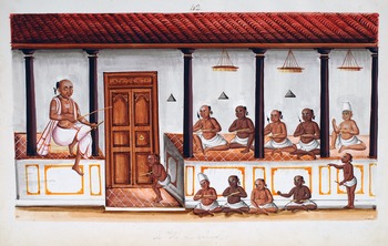
What the Dutch did not understand was that the parish schools they funded were part of a regional educational system in which schoolmasters taught in semipublic veranda schools called tinnai pallikkutams (see Figure 4). These schools were the primary method in the seventeenth, eighteenth, and early nineteenth centuries by which male Tamil children from dominant castes were taught their ethical, literary, and sacred heritage. The tinnai pallikkutam school was designed around cultivating the spoken word as the ideal form of knowledge. Teachers led boys and young men (almost exclusively) through elaborate memorization processes that would facilitate giving devotion or transmitting knowledge orally. Palm-leaf texts—from lengthy grammars and lexicons to astronomical and medical treatises and epic, sacred literatures—were all memorized verbatim.Footnote 25 Various pedagogical methods were used to make these feats of memory possible, including composition forms that incorporated meter, verse, and concatenation as well as various body gestures, from head movements to hand gestures.Footnote 26
Anonymous Indian artist, “A Hindu School,” ca. 1830, 35 × 22 cm, CWML MSS 500. (Image courtesy of Council for World Mission archive, SOAS Library.)

Long before seeing a tinnai pallikkutam, a visitor would hear the lessons in progress. British and American missionary reports are filled with descriptions of hearing the tinnai pallikkutam's soundscape, which struck foreign ears as a cacophony. The preponderance of sound can be explained in two interrelated ways: devotional and pedagogical. First, speech is critical to Saiva and Vaisnava devotional practices that predominated in Jaffna at the turn of the nineteenth century and which were the primary way of communicating with the divine. As Bhavani Raman has argued, even the texts used were not repositories of knowledge as paper books are understood today but rather mnemonic devices or tools to enable precise memorization and thus facilitate faithful recitation.Footnote 27
One of the key pedagogical activities found in tinnai pallikkutams of the period was a practice named call-and-repeat, a question-and-answer method in which the teacher would ask prepared questions and receive standardized, often collective, responses.Footnote 28 This method, used extensively, often appeared to outsiders as chaotic, despite being time-tested and carefully honed. Seventeenth-century Dutch minister Philip Baldaeus, in a survey of his life and work in Ceylon, notes this method while lamenting the linguistic challenges for a foreigner spreading Christian knowledge: “But the greateſt Trouble that belongs to a Miniſter in these parts, is the Inſtruction to be given both to young and old by way of the mouth, which is beſt done by way of Queſtion and Anſwer, which makes the deepeſt impreſſion into the Minds of theſe tender Chriſtians.”Footnote 29
Tinnai pallikkutams relied upon an intimate relationship between texts, bodies, and knowledge to share sacred knowledge that bound Tamil speakers to various, often overlapping, geographical areas. The geographic knowledge embedded in Tamil sacred texts is vast and complicated, and so this depiction should be considered an imperfect heuristic device for thinking about the various ways these texts connected their readers to shifting spaces of significance. These sacred areas can be imperfectly described in three ways: a pan-Indian geography, a regional Tamil geography, and a subregional Tamil geography.
Perhaps the predominant form of sacred geographic knowledge that circulated across these Tamil spaces at the turn of the nineteenth century were pan-Indian puranic depictions rooted in a north Indian medieval Sanskrit cosmopolis, to use Sheldon Pollock's term.Footnote 30Purana refers to a form of hagiographic or biographical sacred literature that deals with the lives of gods or saints, wrapped in often marvelous storytelling, and which Daud Ali has described as the “organizing logic of land, kingdom, and cosmos” in medieval India.Footnote 31 Several texts being taught in Jaffna's tinnai pallikkutams fit into this genre. For instance, the late-fourteenth century poet Kacciyappa Civacariyar's Kantapuranam had a profound impact on sacred practices in Jaffna and is one of a handful of important texts (along with Civananapotam and Periyapuranam by fellow medieval poets Meykantar and Cekkilar) that helped spread Saiva Siddhanta, the Saiva school of thought. Kantapuranam relays the story of Kantan, or Skanda, a son of Siva and Parvati and an important figure for Saiva devotion in Jaffna.Footnote 32
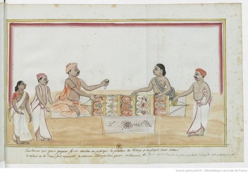
The cosmography represented in Kantapuranam largely accords with dominant pan-South Asian puranic depictions of a flat earth, made up of seven concentric island continents separated by seven concentric seas of sacred substances such as ghee, sugarcane juice, and milk. At its center is Jambu-dvipa, the Rose-Apple Island, with Meru (Mount Kailash, the abode of Siva) standing at its heart and Bharata-varsa, the land now identified as South Asia, in the southernmost region.Footnote 33 This widespread cosmology also appeared in venues outside the tinnai pallikkutam, such as in temple functions, where it was ritually recited, and in public narrations of puranic stories related by itinerant storytellers, like the one portrayed in Figure 5. Missionary records from the early nineteenth century indicate the pervasiveness of the Kantapuranam cosmology. For instance, in July 1828, Batticotta Seminary graduate Leopold Dober discussed the spherical shape of the earth with an unnamed Jaffna astrologer, who responded that he “thought it quite contrary to common sense that the earth is round.”Footnote 34 Puranic cosmographical knowledge, like that found in the Kantapuranam, was common in the region, and was a view of the universe that linked Tamil speakers in Jaffna to diverse South Asian communities across the subcontinent.
Svami [Indian artist], “Pandarou [pandaram, non-Brahmin priest],” ca. 1780, 27.5 × 21 cm. (Image courtesy of Bibliothèque nationale de France.)

The sacred geography taught in the tinnai schools also connected Jaffna students to explicitly Tamil spaces. We can see such a Tamil-specific sacred landscape in the bhakti, or devotional literatures, about a group of South Indian saints called the Nayanmars. The sacred hymns of the Nayanmars form a devotional canon brimming with Tamil speakers in Tamil lands performing a range of selfless and sometimes self-sacrificial activities to demonstrate their devotion to god in the form of Siva. Norman Cutler has shown that one of these Saiva bhakti texts, medieval poet Manikkavacakar's ninth-century Tirukkovaiyar, melds a pan-Indian, puranic cosmology with the deeply Tamil aesthetic and spatial register of tinai,Footnote 35 a landscape-based schema found in the Tolkappiyam, the classical Tamil manual of grammar and poetics from the first century CE.Footnote 36 A. K. Ramanujan has illustrated how this system makes occupation, mood, season, flora, and fauna, as synecdoche for a spatial order of five idealized Tamil landscapes: kurinci (mountain), mullai (forest), neytal (seashore), marutam (pasture), and palai (wasteland).Footnote 37 In so doing, Tirukkovaiyar creates a multilayered sacred space of a pan-Indian puranic cosmology and a uniquely Tamil spatial aesthetic, connecting Jaffna's tinnai students to a network of sacred geographies that approximated the modern South Indian state of Tamil Nadu.
The final example of a sacred space that Jaffna's early nineteenth-century tinnai students would have encountered emphasized a distinct, subregional Tamil character centered upon a particular town or district's devotional landscape. One of the most popular Tamil literary genres between the late seventeenth and mid-nineteenth centuries carried such a subregional character: the kuravanci dance-drama.Footnote 38 Indira Viswanathan Peterson has described the kuravanci genre as flourishing partially as a response to the rapid social, political, and economic forces transforming the region, such as expanding foreign colonial powers.Footnote 39 The central narratives of these dance-dramas fit a standard model: an itinerant adivasi (tribal) fortune-teller narrates her journey around the world while predicting the fortune of a young women smitten with the deity or monarch she encounters.Footnote 40 Peterson has explored several examples of the genre, composed and performed amid the flourishing cultural world surrounding the early nineteenth-century court of Serfoji II, the extraordinary king of Tanjore notably educated by German missionaries. One such composition is Bethlehem Kuravanci, by the evangelical Christian poet Vedanayagam Sastiri. Among other things, Sastiri's work reflected the growing social and political position of Christianity in South India in general, and in Tanjore in particular, at the turn of the nineteenth century. Key portions of the work narrate the global geographic knowledge the German missionaries brought to South India; for instance, Noah's Ark is said to have passed England, Spain, Russia, and Pennsylvania.Footnote 41 By turning the kuravanci genre into an articulation of Christian devotion, Sastiri harnessed an existing performative and literary Tamil pedagogy of geography to connect Tamil listeners to a South Asian Christian sacred geography of special significance to Tanjore, just as they had learned about Mount Kailash and Jambu-dvipa. The work can be considered part of the body of circulating performance literatures that distributed knowledge of regionally specific sacred geographies to students in Jaffna's tinnai pallikkutams.Footnote 42
In the early decades of the nineteenth century, Jaffna's tinnai pallikkutams transmitted knowledge of overlapping sacred geographies, connecting students to Tamil ideas and Tamil lands of varying sizes and distances. Puranic literatures connected Tamil speakers with conceptions of the cosmos and a geography of the earth that they shared with an expansive, North Indian Sanskrit literary tradition. Tamil bhakti literature brought Jaffna's students into contact with the dense network of devotional spaces that gave Tamil land a distinct sacred character. Other literature focused on subregional, city, or district sacred spaces, and highlighted for Jaffna's students the regional attributes of Tamil devotional life. Having described the multilayered sacred geographies transmitted through Jaffna's tinnai pallikkutams, the next section discusses the origins and operations of a radically different approach to geography that, from about 1820, began to transform how Jaffna's students thought about space and belonging.
Geography Textbooks and Pedagogy in the American Ceylon Mission
Well before an American mission in Jaffna was established, American missionaries were teaching geography in Ceylon. Within weeks of arriving on the island in May of 1816, American missionary Horatio Bardwell began giving geography lessons to local students in the colony's capital, Colombo. In a letter back to ABCFM headquarters in Salem, Massachusetts, the missionaries described geography as “a science which is utterly unknown to the Natives, and deserves a particular attention in the plan of their education, as it is certainly well calculated to enlarge their minds, and remove many of the prejudices under which they labour.”Footnote 43 That is to say, the missionaries believed geography would be particularly useful in undermining the local cosmologies that underpinned sacred beliefs and practices. As Richard Fox Young and Subramaniam Jebanesan have highlighted, geography was not unique in this respect; the mission also mobilized astronomy and scientific astronomical calculation to challenge and undermine Saiva cosmology.Footnote 44 This section builds upon Young and Jebanesan's work to demonstrate how geographic pedagogies and textbooks contributed to the ACM's efforts to undermine Tamil ways of knowing and being in the world.
The story of how geography pedagogy operated in Batticotta Seminary—the ACM institution in which Robert Breckenridge and hundreds of other students learned about the world and how to draw it—begins in North America with debates over how students should be taught about space and what the ultimate goal of the exercise should be. In the first decades of the nineteenth century, Jedidiah Morse's series of textbooks were the gold standard of American geographic training, and were themselves great leaps in the presentation of “universal” geography, that is, encyclopedic and scientific descriptions of the entire world explicitly designed for an American audience.Footnote 45 The works included a small number of reference maps, with the primary lesson transmitted through prose descriptions. Morse's ambition to cultivate patriotism is explicit, for instance, when he states that his goal is to “form minds upon republican principals” in an effort to prepare young Americans “to discharge the duties of publick office with honour and applause.”Footnote 46 From the first ACM schools in the last years of the 1810s to the year Breckenridge drew his maps, the ACM relied upon a variety of geography textbooks, all influenced by Morse. There is no evidence to suggest the mission was explicitly drawn to these textbooks due to their ambitions to cultivate national sentiments, and so importing this ideologically laden pedagogy appears to have been incidental to their goals of disseminating what was referred to as “useful knowledge.”
As the ACM was at the vanguard of American mission education, it had to experiment with various texts to satisfy its unique needs. Based on the mission's predominant operating theory, both Christian knowledge and “useful knowledge” (that is, a range of disciplines evincing scientific and moral principles) were identified as necessary to facilitate a true conversion. This theory can be traced to the eighteenth-century pedagogical experimentation of August Hermann Francke. The combination of scientific examination and Christian knowledge were crucial aspects of both the experimental educational institutions Francke built in Germany as well the Danish-Halle Mission, the first Protestant mission to South India, which he helped bring about.Footnote 47 This mission at Tranquebar was only a day's sail from Jaffna and it became an ideological and methodological resource for the American mission through the exchange of letters and personnel.Footnote 48 This link helps explain why education became the most important evangelical method the mission pursued, above and beyond public preaching, distributing religious texts, and constructing hospitals. In other words, educational activities were at the very heart of the mission's larger conversion experiment.
Though we do not know the titles of the first geographic textbooks the mission used, the earliest reference to the teaching of geography in Jaffna dates from 1821, in the homeschool of missionary Daniel Poor in Tillypally (Tellippalai), two years before Batticotta Seminary was established.Footnote 49 By the beginning of 1826, letters to the ABCFM (then headquartered in Boston) record that students at Batticotta Seminary were already spending hours drawing maps, though it is difficult to determine the pedagogical methods used to produce them and the purpose behind their production.Footnote 50 The first geography textbook the mission recorded using, in 1827, was J. A. Cummings's First Lessons in Geography and Astronomy (1819). Cummings's work followed in Morse's footsteps, and similarly his methods principally relied upon prose depictions of space. In 1831, a new textbook arrived in the mission that transformed the way the mission's students interacted with their geography lessons: William Woodbridge and Emma Willard's Universal Geography (1824).Footnote 51
As Schulten has explored in some depth, Willard in general and Universal Geography in particular were responsible for revolutionizing the relationship between American students and the study of geography, engendering a national spirit by engaging the bodies of students as active participants in drawing the nation's borders.Footnote 52 Woodbridge and Willard's Universal Geography provides detailed instructions for how teachers can use the textbook to transform a student's body into a primary tool for cultivating memory. The ideal lesson would begin with a careful examination of the map to be memorized, from the lines of longitude, and latitude to the primary rivers, mountains, oceans, and bodies of water that make up the country's contours and borders. With that image cast in each student's mind, the map would be put away and the pupils would be directed to draw it, starting with the borders and entering all the detail that could be recalled regarding principal landmarks. Once an attempt was completed, the instructor would walk around the room correcting and guiding the students’ drawings. The lesson would be repeated over and over, each student gradually correcting their maps and adding more detail until the instructor was satisfied. Eventually, students would learn to compare and classify what was seen and drawn: this river is bigger than that river, these people are more numerous than those people. Each time the map was produced, the amount recalled by memory would improve until it was locked safely in mind, ready to be recalled and redrawn at will.
Though the mission's use of geographic textbooks would vary over time, Willard's map-drawing method appears to have had great longevity in the mission, with evidence indicating it remained well after Batticotta Seminary was closed in 1855 and into the late nineteenth century.Footnote 53 This was the method that connected Frances Henshaw, who drew the map of Vermont (see Figure 1), and Robert Breckenridge, two nineteenth-century students studying American geography on either side of the earth. Just as Henshaw's map exemplify “making the nation manifest,” to use a phrase from Schulten, the Breckenridge maps point to the facilitation of a Jaffna Peninsula-based Tamil national identity.Footnote 54
In the years following the introduction of map drawing and Willard and Woodbridge's methods, it became clear to the missionaries that the American textbooks being used provided insufficient detail on the specific circumstances of the mission. In particular, the missionaries needed more geographic detail on South Asia that would help them to disprove puranic cosmology. Responding to this need, in 1839 the ACM published The Hindoo Traveller to use alongside the American textbooks. The English-language work can be considered a local adaptation of Samuel Griswold Goodrich's popular American Peter Parley's Method of Telling About Geography to Children (1829), and follows a fictionalized sightseer around South Asia. The Hindoo Traveller mimics Peter Parley’s approach and introduces various parts of the subcontinent using approachable, first-person prose, including Tamil type and words in the text for the first time in a textbook of its type.
The Hindoo Traveller also displays the mission's new depth of understanding about local knowledge systems. Significant portions of the text include heavily condensed and edited versions of puranic and other South Asian sacred literature in order to demonstrate the rationality and superiority of Christian revelation and natural science. For instance, the origin story of the Brahmaputra River as depicted in the Sanskrit-language Kalika Purana is carefully recounted: though the “particulars of the story are too disgusting and indecent to be at all repeated,” the narrator inveighs, the river came into being as a result of the child born to Brahma and Amogha, the wife of the teacher Santanu.Footnote 55 Depictions of South Asian cosmology and geography in The Hindoo Traveller, primarily depicted in an effort to undermine their veracity, are described as inaccurate and imprudent foibles in comparison to the restrained and scientific demonstration of Western geographic knowledge and the sacred teachings of Protestant Christianity. “So says the Purana;” The Hindoo Traveller states, “but can a number of books filled with silly and indecent stories like this be indeed true revelations from God? Can we reasonably expect to receive salvation by means of such gods who were liars and adulterers, deserving to be cursed and trembling with fear of the curse which they merited?”Footnote 56
While The Hindoo Traveller was clearly designed to undermine confidence in the puranic knowledge taught in the tinnai pallikkutams and that students were exposed to in Jaffna society, the work largely represents space in the dominant, textual fashion of American geography pedagogies in the period leading up to Woodbridge and Willard's innovation. That is to say, multiple geographic texts with different pedagogical approaches and ideological purposes were operating side-by-side in the mission to fulfill the mission's complex need to simultaneously evangelize and civilize through the distribution of “useful knowledge.”
The mission was not the only foreign institution that sought to promote this mixture of civilization and Christianity in Jaffna; the British colonial state was also a key figure in the stability and direction of Batticotta Seminary and maintained the right to close the institution at will. Perhaps the most dramatic examples of this collision of American imperial and evangelical education and British colonial interests are found in Batticotta Seminary's annual public examinations. In addition to determining individual student progress and incentivizing student achievement, examinations became public expositions designed to publicly disseminate the merits of Western scientific cosmologic and geographic knowledge as well as to demonstrate the efficacy of the mission's labor to officials in the British colonial bureaucracy. Two such expositions occurred in June and September of 1832, the first conducted entirely in Tamil before an audience of interested local residents, the second in English for a visiting special guest, Sir Robert Wilmot-Horton, then governor of Ceylon.Footnote 57
Batticotta Seminary's June 1832 examination was held in the school's chapel, the room filled with curious onlookers from Vattukkottai village. The Tamil event was overseen by Poor, who opened with a reading from Psalm 19 that neatly demonstrates how intertwined the mission considered Christian sacred knowledge and scientific observation of the universe: “The heavens declare the glory of God; and the firmament shows His handiwork.” The examination of students began with questions on the system of Tamil arithmetic and two Tamil texts, one a grammar (either the Tolkappiyam or Pavananti's Nannul) and the other a work of morals (likely, Tiruvalluvar's Tirukkural or Auvaiyar's Atticuti). Fluency in any one of these texts would have signaled to the audience a great accomplishment based on the standards of a “classical” Tamil education, that is, from a tinnai pallikkutam. But as the visitors to the mission would go on to see and hear, the streams of knowledge the seminary students were exposed to went well beyond the type, form, and content expected from tinnai training.
Next, a student would read a section of his prize-winning translation of Scottish politician and public education advocate Henry Peter Brougham's 1827 essay, “A Discourse on the Objects, Advantages, and Pleasures of Science.” This reading was followed by examples of the use of trigonometry and the process of determining the heights and distances of objects a great distance away, and applications of how the method is used for surveying in conjunction with a transit. After these examinations were completed, the day's event turned to its final part, which perhaps best reveals one of the mission's larger purposes. The concluding session of the seminary's public Tamil examination was a multipart public trial comparing the relative merits of the geography and cosmography espoused by Saiva doctrine with those of Copernican theory. Students began by reciting portions of the Kantapuranam that describe South Asia's sacred geographies, while their hand-drawn maps were exhibited to illustrate the puranic depiction of space: a flat earth with Siva's abode, Meru, at the center and the Jambu-dvipa, the Rose-Apple Island, all surrounded by seven concentric island continents and sacred-substance seas.
Next came student presentations demonstrating that the earth is a sphere and the solar system is heliocentric, explaining the causes of lunar motion and eclipses and showing how to use trigonometry to reveal the planet's convexity. The crowd's reaction to this argumentation, visually depicted through maps of both systems, is not recorded. This is not surprising, given that previous public events that antagonistically attempted to undermine the Kantapuranam had ended in turmoil, protests by local community members, and a boycott of further Kantapuranam recitations by seminary students.Footnote 58 Regardless of whether the mission's visitors expressed a change in their convictions, the event, like other annual events held during the period, were important public articulations of the mission's project that harnessed geographic and Western scientific knowledge in service of their sacred, American, and “scientifically objective” world view.
For the mission, Governor Wilmot-Horton's visit three months later was of no less significance. There was great prestige and potential for fund-raising associated with welcoming to the school the most powerful person on the island, a representative of the most consequential government in the world. But even more importantly for the ACM, Wilmot-Horton's 1832 visit to Batticotta came after a decade of censure from a previous governor of Ceylon who had been particularly hostile to the Americans and sought to limit the ACM's growth and activity. The colonial government was still questioning the very existence of the mission when Wilmot-Horton visited the seminary, and thus the demonstration of its value for the British Ceylonese government would be consequential for its continued presence on the island.
In this context, the students’ presentation before Governor Wilmot-Horton, from their hand-drawn maps to their debate between Copernican and puranic cosmologies, was a civilizational tour de force that legitimized colonial rule. Wilmot-Horton's own perspectives of the event were not recorded, but the restrictions on the mission were soon disbanded, and a British commission reviewing the colony's governance upheld the ACM's education system as a unique model of success, to be further encouraged.Footnote 59 From the mission's viewpoint, the hand-drawn maps demonstrated the inadequacy of Tamil geography as well as the mission's larger value to the empire. Thus, geographic pedagogy played an important role in the ACM's larger conversion experiment that united “useful” and Christian knowledge in challenging Tamil ways of understanding space.
A Nation of Ink and Paint: Mapping in the American Ceylon Mission
As we have just seen, the ACM's approach to teaching geography had a direct impact on how its students interacted with the space in which they lived. In this section, I closely consider a set of maps, including those produced by Robert Breckenridge, to track how the mission's mapping of Jaffna created a standard view of the peninsula that continues to represent the peninsula in the Jaffna Tamil national imaginary.
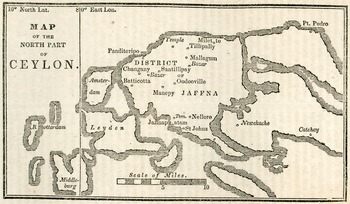
Evidence suggests that the first maps of the Jaffna mission were created as educational tools for the benefit of both the mission's students and the American Christian network invested in the mission's project.Footnote 60 A rudimentary sketch of the mission's immediate environs was reproduced in 1831 in the ABCFM's The Missionary Herald, enabling American supporters to closely follow the “missionary intelligence” from Jaffna (see Figure 6). Ruth Kark has written about nineteenth-century Protestant missionary production and circulation of cartographic knowledge, and the ACM's mapping work is a good example of this larger opus.Footnote 61
“Map of the North Part of Ceylon,” The Missionary Herald, vol. 27, no. 9 (Boston: Crocker and Brewster, 1831), 268 (Map courtesy of the United Church of Canada Archives).

The 1831 “Map of the North Part of Ceylon” is interesting for several reasons. First, the projection is narrower than later depictions, focusing on the region of Jaffna where the ACM predominated (Valikamam) and excluding the portion of the peninsula that connects to the rest of the island. The rudimentary depiction of the region's topography is also significant, as it reveals the mission's limited ability to improve its map using the surveying equipment it possessed. Though lines of latitude and longitude appear, they are rough estimates and it is hard to determine whether they were based on observational data or taken from an unknown source.Footnote 62 Finally, the choice of sacred points of interest is important. The map's compilers recorded not only the locations of their own mission stations (listed as Batticotta, Manepy, Oodooville, Panditeripo, and Tillipally) but also those of the British Christian Missionary Society (Nellore) and the Methodist Mission (Jaffnapatam), several of the markets or bazars where they would preach in public, as well as two Saiva temples. It is unclear why the map notes only two temples, as a considerable number of sites of local Saiva and Vaisnava devotion could have been indicated and certainly far more than the number of mission stations.
Two years later, in 1833, The Missionary Herald published another map of Jaffna that reveals the mission's growing abilities to more accurately track space in the peninsula (see Figure 7). The “Map of the District of Jaffnapatnam in Ceylon” has a slightly expanded projection that includes the entirety of the Jaffna Peninsula and the island of Netuntivu (Delft), providing the standardized cartographic representation of the peninsula that was to predominate in the mission into the twentieth century, and was used as a model for Breckenridge's maps. The map replaced much of the sacred geographic data included in the 1831 version with the names and borders of parishes. Lines of latitude and longitude have also been adjusted from the 1831 map.
“Map of the District of Jaffnapatnam in Ceylon,” The Missionary Herald, vol. 29, no. 10 (Boston: Crocker and Brewster, 1833), 61 (Map courtesy of the United Church of Canada Archives).

Between the 1831 and 1833 maps of Jaffna, we can see the ACM changing its design focus from the sacred geography of interest to the mission and its American sponsors to what could be considered a more scientific presentation of the land and parishes of the peninsula, complete with updated scientific calculations recorded in the adjusted lines of latitude and longitude. At a time when observable, scientific accuracy was being mobilized to disprove local spatial knowledge, the documentation of land and people through “scientific truth” turned the map into an evangelical tool.
Turning to the Breckenridge maps themselves, both were drawn and painted on the same size blue-tinted paper. The maps share a scale, a matching though not identical reproduction of the peninsula's contours (evidence they were not traced), as well as many of the same major attributes, such as colored and named parishes and islands (some with both Tamil and European names listed in the Roman alphabet), limited sea depth data, and the names of coastal villages. It appears the map Mount Holyoke now holds (Figure 2) was created with slightly more care, as the ink lines are generally finer, the cartouche is more elaborate, and the watercolor work is more delicate. Mount Holyoke's copy was sent in August 1847 by Susan Reed Howland to her classmate Mary C. Whitman, who shortly thereafter become principal of Mount Holyoke Female Seminary. Howland sent the map as an attachment to a letter describing life in the mission, suggesting that it and “a few general remarks … may be useful when reading letters from Ceylon.”Footnote 63
The map Yale currently holds (Figure 3) was donated to the university in 1870 by Edward E. Salisbury, the Yale professor and orientalist scholar of Arabic and Sanskrit, along with his extensive collection of rare books and manuscripts. We do not know how he came to own one of Breckenridge's maps, although membership in the American Oriental Society put Salisbury into close contact with two people capable of securing it: Rufus Anderson, the long-standing ABCFM secretary, and Miron Winslow, the missionary-scholar and Tamil dictionary compiler who lived in Jaffna between 1819 and 1833.Footnote 64
It cannot be determined whether the two maps were created at the same time or months or years apart. While the map at Yale was undated, the map at Mount Holyoke is inscribed “1847,” and was likely made in the summer months of that year, just prior to being sent to Massachusetts. Based on the data listed for each parish that the British Ceylonese state collected during the 1840 census, the two maps could have been made as early as June 1841. The ACM republished this census data in a number of venues, and it would have been easily accessible to Breckenridge while he was creating his maps.Footnote 65
One of the striking absences from both maps is any obvious reference to Jaffna's sacred geography. As previously noted, developing the standardized projection of Jaffna entailed removing references to sacred spaces, which enabled the mapmakers to claim a scientific objectivity in their attempt to undermine Tamil sacred geographies. Breckenridge's choice to similarly omit sacred sites from his maps indicates how this purpose was normalized and reiterated. Only information that met the rubric of “scientific objectivity” and could be independently verified—such as knowledge of trigonometry, the use of a transit, and statistical data calculated by the state—was qualified to be added to the map. Accordingly, in addition to being an imported pedagogical process significant in the crafting of a national identity, the map also illustrates the results of the linked civilizational and evangelical conversion experiment that the ACM conducted and the British colonial government sanctioned.
How can we distinguish the implications of pedagogical mapmaking in Ceylon from its impact in America? Perhaps the most obvious difference was the intention behind the lesson. In both America and Jaffna, geographic training fit into a larger rubric of “useful information” that served a general civilizational purpose; history, geography, natural science, and classical languages and thought transmitted the pinnacle of human advancement. But in Jaffna this general purpose also performed a specific evangelical goal that was not a primary concern of the textbook writers of the early American republic—hence the need for the mission to produce its own textbooks from the mid-1830s. Teaching an American sense of patriotism was never listed as a goal for the ACM, and it appears to have been an unintended consequence of their repeated choice to rely on American textbooks.
Second, a gender disparity existed between Jaffna and the United States in the uses of this pedagogy, as student map drawing in Jaffna was consistently (although not exclusively) a male activity. As Schulten has uncovered, map drawing in the early republic was predominantly an aspect of female education: 85 percent of the more than one hundred examples she examined were produced by girls and young women.Footnote 66 For these female students, map drawing, stitching, and painting were part of a larger set of “accomplishments,” including various types of needlework, musical training, cultivated literacy, and a comportment that designated the creator as eligible for marriage.Footnote 67 In Jaffna, the study of geography by the mission's female students lagged behind Batticotta Seminary by several years. In 1824, the year Oodooville Girls College was founded, the mission recorded that while some of Batticotta Seminary's students had commenced studying geography, the girls and young women at Oodooville would only do so once sufficiently prepared.Footnote 68 By the close of 1828, this expectation had been fulfilled, and Winslow records that John B. Fraiser (also known as Cuvaminatar Karttikecan), one of the first graduates of Batticotta Seminary, had been employed at Oodooville to conduct the lessons.Footnote 69 While this delay points to a gendered division that privileged the teaching of geography to the young men of the mission, this differential could also partially result from delays caused by the distinct challenges the missionaries faced at Oodooville regarding female literacy.Footnote 70 Although we know Batticotta Seminary students spent hours working on maps from January 1826,Footnote 71 it is not until 1849 that Oodooville students were encouraged to do so.Footnote 72
Third, while Breckenridge's maps were made within a decade of the period that Schulten identifies as being the core of student mapmaking activity in America (the 1790s to the 1830s), a slightly different periodization of maps in Jaffna should be noted.Footnote 73 The last hand-drawn maps of Jaffna likely produced as a result of this pedagogical process were created by Tamil ACM preacher and mission school alumnus Isaac Paul in 1926.Footnote 74 An earlier example of Paul's map making skill, from 1907, can be seen in Figure 8. Clearly, student map drawing had exceptional longevity in Jaffna, well past its heyday in the United States.
Isaac Paul, “Jaffna Peninsula” 1907. 45 × 78 cm. ABC 79, Box 3, Folder 6 (Map by permission of Houghton Library, Harvard University).

Conclusion: The Breckenridge Maps as Incomplete and Consequential
It may come as no surprise that the ACM's decades-long effort to overcome local ways of interpreting the cosmos with geographic knowledge was largely unsuccessful. In fact, the mission's antagonism was partly responsible for a counterproject to defend Hinduism led by former students of one of Jaffna's British missionary boarding schools.Footnote 75 The number of converts to the American and British Protestant churches was always meager, to the great disappointment of mission administrators in Boston. But the lack of converts risks obscuring the mission's true importance, which lay in its distribution—intentional and otherwise—of a set of distinctly American ways of being in the world, one of which was a national character.
Despite the dramatic effect ACM teaching had on the way mission students interpreted the world and their place in it, the mission's geographic teachings never completely replaced the layers of Tamil sacred space that students encountered in tinnai pallikkutams. Though the ability of Western science to explain certain cosmological and geographic truths would eventually be commonly accepted, the vast majority of Jaffna's population lived with what the mission considered a contradiction without difficulty. In the end, people in Jaffna embraced the spatial knowledge of colonial modernity contained in the American map making pedagogy as a parallel way of seeing the world that could serve their needs, such as qualifying for government employment.
In addition to the numerous puranic and Tamil-centric sacred geographies to which students in Jaffna were connected, the ACM brought another way of thinking about space and identity to the Jaffna Peninsula. While the mission never completed its project to overturn local ways of seeing the world, it was still consequential. Encounters with Western-style education help explain the nineteenth-century construction of a particular Jaffna Tamil identity, epitomized by the Tamil civil servant who valued education, was fluent in the English language, and had an inextricable bond to the Jaffna Peninsula. Thongchai Winichakul has described how maps predated the modern Thai nation, explaining that “a map was a model for, rather than a model of, what it purported to represent.”Footnote 76 By employing Emma Willard's method of mapping their surroundings, ACM students like Robert Breckenridge modeled this new Jaffna Tamil identity, reinforced by the repeated strokes of pen and brush on paper: a Jaffna Tamil nation of ink and paint.