Introduction
Streams are important components of aquatic ecosystems in Antarctica, as they are conduits of chemicals and water from glaciers and snowpacks to lakes and the ocean (Lyons et al. Reference Lyons, Welch, Neumann, Toxey, McArthur, Williams, McKnight and Moorhead1998) and are loci of important biogeochemical reactions (McKnight et al. Reference McKnight, Niyogi, Alger, Bomblies, Conovitz and Tate1999). Surprisingly, the geochemistry of Antarctic streams can be quite diverse reflecting landscape position, geologic substrate, hydrological characteristics and biomass concentration (Hodson et al. Reference Hodson, Heaton, Langford and Newsham2010, Welch et al. Reference Welch, Lyons, Whisner, Gardner, Gooseff, McKnight and Priscu2010). Byers Peninsula, Livingston Island, has a number of streams of varying lengths and gradients that move through differing geological and ecological conditions (Lopez-Martinez et al. Reference López-Martínez, Serrano and Martínez De Pisón1996a, Toro et al. Reference Toro, Camacho, Rochera, Rico, Bañón, Fernández-Valiente, Marco, Justel, Avendaño, Ariosa, Vincent and Quesada2007). Because of the importance of Byers Peninsula as a potential international reference site for long-term investigation and monitoring of terrestrial and limnetic conditions (Quesada et al. Reference Quesada, Camacho, Rochera and Velázquez2009), it is important to describe the current geochemical characteristics of streams on Byers so that these data can be compared to future information gathered at these sites and also to compare to on-going work at other locations in Antarctica. Stream features and fluxes determine not only the functioning of the stream ecosystems, but also greatly determine many ecological features of the lakes to which they are connected, and enhance the effects of biological activities within lake catchments (Camacho Reference Camacho2006). All this information is needed in order to assess the impact of future climatic warming on stream and lake processes as well as future elemental and water fluxes generated by this warming.
During summer 2009, we obtained a series of samples from streams in the Byers Peninsula. A number of these streams had been previously sampled in the 2001–02 summer (Toro et al. Reference Toro, Camacho, Rochera, Rico, Bañón, Fernández-Valiente, Marco, Justel, Avendaño, Ariosa, Vincent and Quesada2007). We posed a number of questions prior to our fieldwork. These included: how fast do these watersheds respond to precipitation events; what are the influences of vegetation, and more importantly, watershed lithology on stream geochemistry, and what are the chemical weathering rates in these small watersheds? Finally, we were interested in comparing the geochemical dynamics of the Byers Peninsula (∼63°S) streams to those in the McMurdo Dry Valleys, Antarctica (∼78°S).
Materials and methods
Study area and sampling strategy
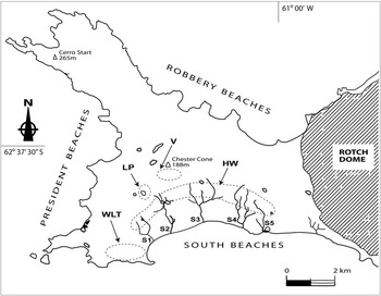
Byers Peninsula, at the western end of Livingston Island, South Shetland Islands, is one of the largest ice-free areas in the Peninsula region of Antarctica at ∼62°34′S to ∼62°40′S. Much has been written elsewhere on the geology, geomorphology, climate, climate history, and hydrology of Byers (i.e. Björck et al. Reference Björck, Håkansson, Zale, Karlén and Jönsson1991, Smellie et al. Reference Smellie, Liesa, Munoz, Sabat, Pallas and Willan1995, Lopez-Martinez et al. Reference Lopez-Martínez, Hathaway, Lomas, Martínez De Pisón and Arche1996b, Toro et al. Reference Toro, Camacho, Rochera, Rico, Bañón, Fernández-Valiente, Marco, Justel, Avendaño, Ariosa, Vincent and Quesada2007). The geology consists of Jurassic–Cretaceous shales and sandstones and volcanic rocks. The climate is maritime and precipitation is much higher than in continental Antarctica (Toro et al. Reference Toro, Camacho, Rochera, Rico, Bañón, Fernández-Valiente, Marco, Justel, Avendaño, Ariosa, Vincent and Quesada2007). Our sampling strategy was fourfold: 1) collect precipitation samples and analyse them for their geochemical and isotopic composition, 2) produce a “time-series” (i.e. daily samples) of geochemical characteristics of one stream to determine daily variability, 3) sample as many streams as possible from diverse lithologies and elevations, and 4) gauge a number of these streams in order to calculate short-term geochemical ‘yields’ from the watersheds. Due to weather delays and departure restrictions, this was accomplished over a twelve-day period from the last week of January through the first week in February 2009. Samples were collected from seventeen streams and one groundwater seep (Fig. 1). Five samples were collected in the “headwaters” of watersheds. Additional samples were taken from the lower ‘coastal-plain’ portion of the streams for comparison. Two sets of samples from Limnopolar Lake (two inlet and one outlet streams) (Rochera et al. Reference Rochera, Justel, Fernandez-Valiente, Bañón, Rico, Toro, Camacho and Quesada2010) were sampled at different times during this period. Stream S1 was sampled daily at the same time every day (∼17h30 local time).
Map of Byers Peninsula, Livingston Island, Antarctica. Samples locations are described as follows: LP = stream flowing into Lake Limnopolar, V = streams draining the volcanic cone region, HW = low-order headwater streams flowing into streams along the south coast (S1–S5), and WLT = western lower terraces. Original map from Toro et al. (Reference Toro, Camacho, Rochera, Rico, Bañón, Fernández-Valiente, Marco, Justel, Avendaño, Ariosa, Vincent and Quesada2007) with our sample locations added.

Sample collection
All stream samples for major ion analysis were collected by hand in pre-cleaned polyethylene bottles. These samples were returned to camp and filtered through 0.4 micron Whatman Nuclepore™ polycarbonate membrane filters using plastic filtering apparatus within a few hours of collection. The filtering apparatus was rinsed with distilled-deionized water. pH measurements were also made on a separate non-filtered aliquot of sample. The filtered water was placed into another pre-cleaned polyethylene bottle, sealed tightly and stored in a cool and dark place. Samples for stable isotope analysis were collected in small glass vials and sealed tightly with no air space and finally taped closed. The samples travelled by ship to King George Island and then were flown back to the USA via Punta Arenas, Chile. Major cation (Na+, K+, Mg2+, Ca2+) and anions (Cl- and SO42-) were analysed at the Ohio State University using a Dionex Ion Chromatograph (DX-120) (Welch et al. Reference Welch, Lyons, Whisner, Gardner, Gooseff, McKnight and Priscu2010). Precision of these measurements were < 2% based on the average percent difference between duplicate analyses of the samples. The HCO3- concentrations in these samples were estimated by charge balance differences between the cation equivalents and the anion equivalents (Lyons et al. Reference Lyons, Carey, Hicks and Nezat2005). Previous work on streams in Taylor Valley, Antarctica where both measurements of alkalinity and charge balance estimates were made on hundreds of stream samples suggest a mean precision of 13% for the estimated HCO3- (Lyons et al. Reference Lyons, Welch, Gardner, Jaros, Moorhead, Knoepfle and Doran2012). In addition, alkalinity values reported for streams by Toro et al. (Reference Toro, Camacho, Rochera, Rico, Bañón, Fernández-Valiente, Marco, Justel, Avendaño, Ariosa, Vincent and Quesada2007) ranged from 0.01 to 1.47 meq l-1, similar to the range of our estimated alkalinity concentrations. Previous work (Jones et al. Reference Jones, Juggins and Ellis-Evans1993, Toro et al. Reference Toro, Camacho, Rochera, Rico, Bañón, Fernández-Valiente, Marco, Justel, Avendaño, Ariosa, Vincent and Quesada2007) has demonstrated that for the most part the nitrate concentrations in the aquatic systems of Byers Peninsula are quite low compared to Cl-, SO42- and HCO3- (< 1 to 4.3 μM) and hence are a minor contributor to the total anionic composition. Dissolved Si (H4SiO4) was analysed using a Skalar San++ Continuous Flow Analyzer and the precision of the measurements was < 5% based on average percent difference of the duplicates. The δ18O samples were analysed at INSTAAR, the University of Colorado. The accuracy of the data from the δ18O analyses is within 0.1‰. In addition to the stream collection, any precipitation (snow and rain) that fell between 15 January and 2 February 2009, was collected, processed in the same manner as the stream samples, and analysed for major ions, dissolved Si and δ18O using the same techniques listed above.
In addition to the collection of water samples, a number of streams were gauged to determine stream flows. This was done by hand using the same procedures as Toro et al. (Reference Toro, Camacho, Rochera, Rico, Bañón, Fernández-Valiente, Marco, Justel, Avendaño, Ariosa, Vincent and Quesada2007) and Goldsmith et al. (Reference Goldsmith, Carey, Johnson, Welch, Lyons, McDowell and Pigott2010).
Finally, chemical weathering yields were determined using the method outlined in Lyons et al. (Reference Lyons, Carey, Hicks and Nezat2005). Two types of weathering yields were calculated: carbonate and silicate (cation yield). These are done in a series of steps, the first being the subtraction of the stream solute load that originates from precipitation. This was done by subtracting the precipitation contribution (from our own precipitation analysis) from the stream values for each of the ions. The total cation yields from silicate mineral chemical weathering were determined using the technique of Gaillardet et al. (Reference Gaillardet, Dupre and Allègre1999), in which a Ca:Na molar ratio of 0.35 was used to determine how much of the total Ca2+ (after contributions of Na+ and Ca2+ from precipitation were subtracted) is derived from silicate mineral weathering. Any excess of Ca2+ above that molar ratio has been interpreted to be derived from CaCO3 dissolution (Gaillardet et al. Reference Gaillardet, Dupre and Allègre1999, Millot et al. Reference Millot, Gaillardet, Dupré and Allègre2003, Pokrovsky et al. Reference Pokrovsky, Schott, Kudryavtzev and Dupré2005). The corrected Ca2+ values are summed along with the precipitation-corrected Na+, K+ and Mg2+ to obtain the concentrations of cations from silicate mineral weathering alone. Yields were obtained by multiplying the Ca2+ from carbonate weathering and the sum of cations from silicate weathering by our instantaneous flow measurements and then dividing by the area of the watersheds as given in Toro et al. (Reference Toro, Camacho, Rochera, Rico, Bañón, Fernández-Valiente, Marco, Justel, Avendaño, Ariosa, Vincent and Quesada2007).
Results
Chemistry
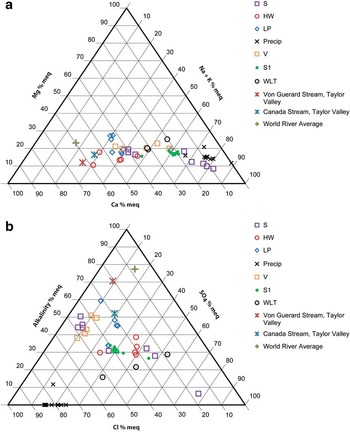
All the geochemical data from this investigation are tabulated in Appendix A. Total dissolved solids (TDS) in the streams ranged from 28 to 240 mg l-1. TDS measured in precipitation ranged from ∼3 to 23 mg l-1. The major ion data for the streams and precipitation are presented in two Piper diagrams (Fig. 2a & b). In general the streams from Byers Peninsula show only small variations in Mg2+, but much larger ones in Ca2+ and Na++K+ (Fig. 2a). Precipitation is the most enriched in the Na++K+ end-member, although a number of the South Beaches (S) streams and to a lesser amount the streams on the lower terrace to the west (WLT) show similar cationic characteristics. The headwater (HW) streams are the most Ca-rich, followed by the Limnopolar (LP) and some of the Volcanic (V) streams (Fig. 1). All of these latter streams originate and/or flow from the interior of the Peninsula where the lithologies consist of uplifted lower Cretaceous non-marine tuffs, volcanic breccias and various grain-sized marine sedimentary rocks (Navas et al. Reference Navas, López-Martínez, Casas, Machin, Durán, Serrano, Cuchi and Mink2008). The ‘WLT’ streams like the lower portions of the ‘S’ streams, primarily drain Quaternary beach deposits though they are located close to the sea and fall intermediate in their percentage of Na++K+ to Ca2+ (Fig. 2a). Note that the world river average and two streams from the Taylor Valley, McMurdo Dry Valleys (MCM), Von Guerard and Canada Stream, are much more Ca-rich than the Byers streams, suggesting that the Na-dominated precipitation and relatively small catchments and potentially short hydrologic residence times help control the cation geochemistry of the Byers Peninsula streams.
Ternary diagram showing a. relative cation concentration in percentage of equivalents, and b. relative anion concentration in percentage of equivalents. Two Taylor Valley, Antarctica streams and the world river average data from Hu et al. (Reference Hu, Stallard and Edmond1982) are plotted for reference.

The major anion data show a much greater geochemical diversity (Fig. 2b). Precipitation is dominated by Cl- with about 20% SO42-. The streams dramatically add HCO3- (i.e. alkalinity) and in some cases SO42- compared to the precipitation. There is little pattern to the distribution of anions, except the ‘V’ streams gain little to no SO42- as they move through the watershed. The Byers ‘S’ streams are depleted in HCO3- compared to the world river average and have less than Von Guerard stream as well. Only one Byers stream has a higher percentage of HCO3- than the Canada Stream. All this indicates that the Byers streams, even though they do gain HCO3- through chemical weathering, are influenced by marine salts in precipitation and sea-spray in general more than the Taylor Valley streams. Again this might suggest shortened residence times in their flow paths. In most cases, the SO42- to Cl- ratio of the stream waters is much greater than those of the precipitation (Appendix A). These high concentrations of SO42- in many of the Byers streams are perplexing and certainly suggests the potential that sulfide mineral oxidation in the bedrock may be a much more important process than previously thought.
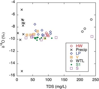
Not surprisingly, precipitation has much lower total dissolved solids (TDS) and wider range of δ18O values than do the streams (Fig. 3). With the exception of only three stream samples, the δ18O ranges between -8 to -10‰ while the δ18O values of precipitation show a much larger variation, from ∼-5 to -15‰ (Fig. 3). These data indicate that the streams represent relatively well-mixed waters and are perhaps more influenced by more depleted sources (i.e. precipitation from slightly colder periods of time) than by precipitation that occurred while we were present later in the summer. One ‘WLT’ stream, and one ‘LP’ stream seem to be most responsive to the more recent, enriched precipitation. Why this is the case is not clear, but probably relates to less influence of “stored” water in these streams.
δ18O versus total dissolved solids (TDS) for water samples included in this study.

Discussion
Time series of S1 stream
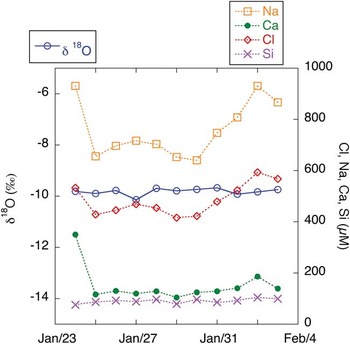
The time series for stream S1 for the constituents δ18O, Cl-, Na+, Ca2+ and dissolved Si is shown in Fig. 4. In temperate streams, many solutes change concentrations as flow changes (e.g. storm flow dilutes higher baseflow concentrations). Precipitation samples were collected throughout the period between 13 January and 2 February 2009 with only a very few days when there was no collectable precipitation (14, 17, 19–21, 24–26, 31 January). Flow measurements were made on both 28 January and 2 February with lower flows observed on 28 January. However, baseflow-dominated solutes such as dissolved Si demonstrate little variation over time. The highest values of Ca2+ are associated with the high Cl- and Na+ values. The Ca2+, Na+ and Cl- tend to co-vary through the time series, probably in response to changes in flow. However, the first sample of the time series is characterized by relatively high TDS as well as relatively higher concentrations of SO42- and Ca2+ compared to the later samples, which tend to have consistent ion ratios (Fig. 2a & b, Appendix A). There is little variation in the δ18O over time, again indicating a relatively well-mixed reservoir of water in this watershed during the period sampled. An interesting observation is that even over a relatively short period in the late part of the summer, soluble elements such as Cl- can vary by 50%, probably coinciding with flow variability as noted above, yet the δ18O of the water does not vary.
Time series of δ18O, Na+, Ca2+, Cl- and Si sampled at stream S1 from 24 January–3 February 2009, at the same time daily.

We measured flows in the coastal streams (S1 to S4) from 0.024 to 0.243 m3s-1 with values for S1 from 0.024 to 0.058 m3s-1 (n = 3). Toro et al. (Reference Toro, Camacho, Rochera, Rico, Bañón, Fernández-Valiente, Marco, Justel, Avendaño, Ariosa, Vincent and Quesada2007) reported flows of between 0.036 and 0.276 m3s-1 between December 2001 and February 2002 in this same stream. Clearly, even with the precipitation events between mid-January and early February 2009, these late summer samplings were at essentially the lowest flow conditions.
Chemical weathering in an Antarctic setting
Much has been written and debated about the importance of chemical weathering in polar environments. Watershed type (i.e. glacier versus non-glacier) stream dynamics and mean annual temperature have been documented to influence weathering rates in polar and high-latitude regions (Gooseff et al. Reference Gooseff, McKnight, Lyons and Blum2002, Millot et al. Reference Millot, Gaillardet, Dupré and Allègre2003). In addition, in maritime Antarctic regions such as Byers Peninsula, much of the precipitation falls as rain, unlike most of the continent. In general, the qualification of the extent and nature of chemical weathering in any watershed has been evaluated in two distinct ways. One way is to evaluate soil geochemical profiles and/or mineral weathering product production as they compare to the original bedrock geochemistry/mineralogy. The second method is to analyse stream waters for soluble constituents produced via chemical weathering reactions and calculate their loss. Both methods have been used to evaluate chemical weathering in Antarctic settings. Because there are extremely low concentrations of dissolved Si in precipitation, it has been used to signify the weathering of aluminosilicate minerals in natural waters. Both Caulkett & Ellis-Evans (Reference Caulkett and Ellis-Evans1997) and Hodson (Reference Hodson2006) observed very low dissolved Si concentrations in Signy Island streams with dissolved Si yields of only 47 kg km-2 yr-1. A comparison of Si content from Byers and Signy Island waters indicates that higher concentrations are observed in Byers (Jones et al. Reference Jones, Juggins and Ellis-Evans1993).
On the other hand, Nezat et al. (Reference Nezat, Lyons and Welch2001) and Green et al. (Reference Green, Stage, Preston, Wagers, Shacat and Newell2005) observed much higher dissolved Si concentrations and higher weathering yields in the McMurdo Dry Valley streams. These higher weathering rates have been attributed to enhanced hyporheic zone dynamics even though the mean annual temperature is lower and there is no groundwater input or overland flow in the McMurdo Dry Valleys (Gooseff et al. Reference Gooseff, McKnight, Lyons and Blum2002).
Previous work on the South Shetland Islands has generated contradictory conclusions. Lee et al. (Reference Lee, Lim and Yoon2004), analysing soil profiles on King George Island, argued that there has been very little aluminosilicate weathering and that the fine-grained mineral fraction in the soils is primarily due to physical, not chemical weathering. They have observed some Ca and Mg depletion in some soils and suggested that this loss is from plagioclase weathering influenced greatly by biological (i.e. lichen) processes (Lee et al. Reference Lee, Lim and Yoon2004). These authors concluded that chemical weathering is insignificant based on the major element abundances in the soils. On Livingston Island, it was first argued that chemical weathering is important and it is greatly enhanced by freeze-thaw cycles (Hall Reference Hall1993). Navas et al. (Reference Navas, López-Martínez, Casas, Machin, Durán, Serrano, Cuchi and Mink2008) have argued that Livingston Island soils are weathering “limited” but that chemical weathering does affect the evolution of the soils and that freeze-thaw and wet-dry cycles aid the weathering process.
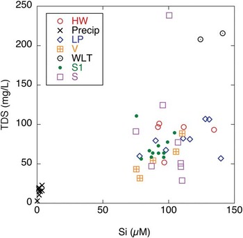
Our data indicate that the streams on Byers Peninsula have dissolved Si concentrations between 75 and 141 μmole l-1 (Appendix A). There is some suggestion that dissolved Si concentrations increase with TDS in these streams, possibly indicating the importance of shallow groundwater/permafrost melt during these low flow conditions (Fig. 5). Clearly these high concentrations of dissolved Si can only be explained by the chemical weathering of aluminosilicate minerals.
TDS mg l-1 versus Si μM for all streams and precipitation samples.

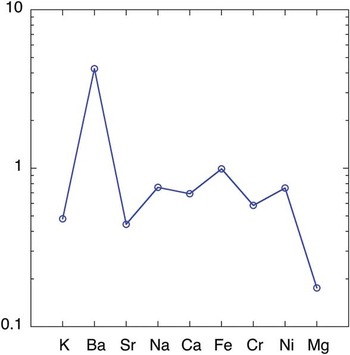
In addition to the dissolved Si concentrations in the streams supporting the contention of significant silicate mineral weathering in the soils on Byers Peninsula, we have utilized the soil data from Navas et al. (Reference Navas, López-Martínez, Casas, Machin, Durán, Serrano and Cuchi2006) from the upper platform of the Peninsula and “normalized” it to andesite bedrock data from Byers Peninsula (#24) from Smellie et al. (Reference Smellie, Pankhurst, Thomson and Davies1984) to produce a “spidergram” (Fig. 6). Points falling below the 1 indicate loss of that element from the soil relative to the bedrock while those values above 1 indicate an increase (Gaillardet et al. Reference Gaillardet, Dupre and Allègre1999). Of the major rock forming elements, there is no loss of Fe but there is significant loss of K, Sr, Na, Ca and especially Mg in the soils relative to the bedrock. In addition to the bedrock and soil data from Byers, there are available tephra analyses from both Midge Lake, Byers Peninsula and from Hurd Peninsula further east on Livingston Island (Hodgson et al. Reference Hodgson, Dyson, Jones and Smellie1998, Pallàs et al. Reference Pallàs, Smellie, Casas and Calvet2001). These tephras are thought to be derived from eruptions from Deception Island to the south. The tephras from the shallowest core depths (i.e. the youngest) of Midge Lake have much higher Fe, higher Ca, slightly higher Na and similar Al, but lower Mg and K concentrations than the local andesite bedrock on Byers Peninsula (Smellie et al. Reference Smellie, Pankhurst, Thomson and Davies1984, Hodgson et al. Reference Hodgson, Dyson, Jones and Smellie1998). Tephras from Hurd Peninsula have similar to higher Ca, similar to slightly higher Na, but lower Mg and K concentrations than the bedrock (Smellie et al. Reference Smellie, Pankhurst, Thomson and Davies1984, Pallàs et al. Reference Pallàs, Smellie, Casas and Calvet2001). A normalization of the soils to the tephra would yield even greater losses of Ca and Na, but lower losses of Mg and minimal K loss from chemical weathering compared to the andesitic bedrock. Therefore, no matter if the bedrock or the ash is a major precursor to the soils from inland on Byers Peninsula, both substrates indicate a substantial loss of base cations relative to the present day soils. This exercise in comparison of the geologic materials strongly suggests that chemical weathering has impacted the soils as previously suggested by Navas et al. (Reference Navas, López-Martínez, Casas, Machin, Durán, Serrano, Cuchi and Mink2008).
Spidergram showing relative enrichment or depletion of elements in soil relative to andesite bedrock. Values less than one show soil depletion relative to rock.

Calculation of weathering yields
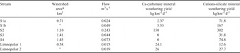
As noted above, in Fig. 2a, Ca2+ is a major component of the solutes in the Byers Peninsula streams. In all but three stream samples, the relative Ca2+ contribution is greater than the mean precipitation value (Fig. 2a). Recent work suggests that even in igneous and metamorphic terranes, much of the Ca2+ in streams and rivers is derived from CaCO3 dissolution, not dissolution of Ca-rich silicates such as plagioclase (Blum et al. Reference Blum, Gazis, Jacobson and Chamberlain1998, Lyons et al. Reference Lyons, Carey, Hicks and Nezat2005). This is true even though CaCO3 may make up a very small percentage of the rock by weight. Crame et al. (Reference Crame, Pirrie, Crampton and Duane1993) have reported calcite layers present in the volcanic lithologies on the Byers Peninsula. Smellie et al. (Reference Smellie, Pankhurst, Thomson and Davies1984) have observed that the mixed marine sedimentary formation contains carbonate minerals as well as calcite cements. Navas et al. (Reference Navas, López-Martínez, Casas, Machin, Durán, Serrano and Cuchi2006) reported carbonate concentrations in the soils ranging from 600–900 μg g-1. In addition, Spanish scientists working in the area have observed that clamshells are commonly seen in the plateau, brought by birds nesting there. All of this previous work suggests that the weathering of CaCO3 could be a major process that helps control the stream Ca2+ geochemistry in the watershed on Byers. Because of this, we have used the technique of Gaillardet et al. (Reference Gaillardet, Dupre and Allègre1999) to compute both carbonate mineral and aluminosilicate mineral yields for streams S1–S4 and the Limnopolar Stream. The results are shown in Table I. A caveat to these calculations is that this technique was developed for much larger watersheds than these on Byers Peninsula and the values presented here should be taken as preliminary in nature.
Calculated calcium carbonate and silicate mineral weathering yields for streams on Byers Peninsula, Livingston Island. Yields of calcium from calcium carbonate mineral weathering and the sum of major cations from aluminosilicate mineral weathering have been estimated.

Carbonate dissolution ranges from 66% of the total chemical weathering (Limnopolar inlet streams) to 0% (S3 and S4). Cation yields from silicate weathering range from as little as 12.6 to as high as 302 kg km-2 d-1 (note that we use yields on a per-day basis in these ephemeral streams that do not flow all year.) The greatest carbonate yield is in S2, which drains both the Quaternary beach deposits as well as marine sediments at higher elevations inland. The two streams further east express no contribution from carbonate weathering, while the smaller more interior stream (Limnopolar inlet) has intermediate carbonate yields between S1 and S2. Interestingly, the low-flow groundwater seep (S5) (Appendix A) had higher TDS and higher Ca2+ concentration than the surrounding streams, but no Ca2+ from carbonate mineral dissolution. The lack of a carbonate contribution to the weathering yields in S3 and S4 may be due to the fact that their upper drainages are dominated by both more igneous rocks as well as volcanic breccias and tuffs rather than marine sedimentary rocks, and the latter presently contain less carbonate material. This idea is substantiated by both the Ca2+ and Mg2+ concentrations in S3 and S4, which are much lower than those in S1 and S2 (Appendix A). There is a variable statigraphical sequence along the Peninsula (Smellie et al. Reference Smellie, Davies and Thomson1980) consisting of marine and terrestrial sedimentary deposits in the west and east parts of the peninsula respectively, with an intermediary region between them. The western part is mainly composed by marine sandstones and mudstones. Moving eastward the area is a mix of volcaniclastic sandstones and conglomerates. Further east from the Chester Cone inclusion until the eastern part of the Peninsula, the bedrock is primarily composed of pyroclastic rocks. This difference in lithology might explain the spatial differences observed in the ion chemistry. Similar observations of the spatial variability of stream chemistry were made by Toro et al. (Reference Toro, Camacho, Rochera, Rico, Bañón, Fernández-Valiente, Marco, Justel, Avendaño, Ariosa, Vincent and Quesada2007) in 2001–02. The Na+ and Mg2+ concentrations in S2 to S4 are very similar between these two studies ∼seven years apart, yet the Ca2+ concentration determined in this work is around double that observed in 2002. The highest silicate yields are from S1 and S2 (Table I). On an annual basis these carbonate dissolution yields are within the range of those observed in larger far northern latitude watersheds in the Mackenzie River Basin, Canada, but our silicate mineral dissolution yields range from slightly higher to an order of magnitude higher (Millot et al. Reference Millot, Gaillardet, Dupré and Allègre2003). Chemical weathering yields from watersheds that drain monolithic basic volcanic rocks in Central Siberia also fall at the low end of our values (Pokrovsky et al. Reference Pokrovsky, Schott, Kudryavtzev and Dupré2005). Our values are also higher than what has been observed for a glaciated basin in maritime Antarctica (Hodson et al. Reference Hodson, Heaton, Langford and Newsham2010). These yields along with the dissolved Si concentrations observed in the Byers streams indicate that chemical weathering is a major process in these watersheds even though the mean annual temperature is low, although during most summers the average temperature is above freezing (Rochera et al. Reference Rochera, Justel, Fernandez-Valiente, Bañón, Rico, Toro, Camacho and Quesada2010). The combination of high precipitation rates in Byers of ∼80 cm (weq), snowmelt and rainfall in the summer, and probably the seasonal dynamics of the active layer, all aid in enhancing chemical weathering in this environment.
Water residence time and permafrost depth have been shown to be very important in the transport and flux of dissolved cations in both polar and alpine settings (Petrone et al. Reference Petrone, Jones, Hinzman and Boone2006, Hindshaw et al. Reference Hindshaw, Tipper, Reynolds, Lemarchand, Wienderhold, Magnusson, Bernasconi, Kretzschmar and Bourdon2011). Noon et al. (Reference Noon, Leng, Arrowsmith, Edworthy and Strachan2002) observed the δ18O of spring melt on Signy Island as low as -13‰ and lake water to be as low as -9‰ in February (late summer). Based on this observation and the compilation of data for Antarctic terrestrial aquatic systems by Noon et al. (Reference Noon, Leng, Arrowsmith, Edworthy and Strachan2002), our measured values for Byers streams appear to be too positive for mean annual precipitation for Byers Peninsula with values approaching -15‰ being more expected. If this is indeed the case, it suggests that much of the precipitation that falls and accumulates during the coldest portion of the year is lost via melt and runoff early in the melt season, again suggesting relatively short residence times of water in these hydrologic systems.
As the climate warms and the depth of water flow increases due to the depth of permafrost melting, increased Ca2+/Na+ ratios have been observed in Arctic streams (Keller et al. Reference Keller, Blum and Kling2010). Increases in the depth of the active layer as the Antarctic Peninsula continues to warm in response to increasing atmospheric CO2 may change cation ratios and increase the flux of weathering yields in these watersheds.
Conclusions
The data presented here demonstrate that there is a large diversity in stream geochemistry in Byers Peninsula streams, both in their cation and anion composition. Inland streams are, in general, more enriched in Ca2+ with respect to Na+. The anionic variation is also very large with some streams dominated by Cl-, others by HCO3- and even others with high percentages of SO42-. In general, the lower elevation portions of the streams have higher associated total dissolved solids. Dissolved Si concentrations range between ∼75 to 141 μM, suggesting that the chemical weathering of silicate minerals is a major process in these watersheds. The dissolution of carbonate minerals is also important, especially in watersheds dominated by marine sedimentary lithologies. Chemical weathering fluxes in these small watersheds when normalized to area are slightly higher to an order of magnitude higher than what has been observed in glaciated watersheds in maritime Antarctica and much larger watersheds in high northern latitudes. Increased warming, increased summer active layer thickening, and/or increased precipitation will lead to increased chemical weathering and solute fluxes in the future.
Acknowledgements
The senior author is greatly appreciative to the Spanish Antarctic Programme and especially Dr Antonio Quesada for allowing his participation in the IPY Byers Peninsula/Limnopolar Project (POL2006-06635) funded by the Spanish Ministry of Science and Technology. He also acknowledges the wonderful working atmosphere of the camp during his stay. Parts of the analytical work were supported by US-NSF grant OPP-ANT-0423595. Work by AC and CR was supported by the Spanish Ministry of Science and Technology through project CGL2005-06549-C02-02/ANT to AC, which was co-financed by European FEDER funds. We thank Bruce Vaughn and his group at INSTAAR for the δ18O analyses. This article was published thanks to the financial support given by the Ministerio de Ciencia e Innovación (Spain) with the grant ref. CTM2011-12973-E. This manuscript is Byrd Polar Research Center contribution C-1422.