

The history of drainage and land reclamation in Britain has generated a sparse and parochial literature, dominated by intensive studies of particular regions. Consequently, the general importance of drainage to the progress of the agricultural revolution has not received the attention it deserves.Footnote 1 Nevertheless, it is arguable that in terms of land productivity and the effects on the landscape, drainage has had a much greater influence on British history than enclosure, although it has attracted only a fraction of the attention. It is apparent that drainage presented technological, financial, administrative, social and political problems each of which had to be overcome. Drainage required considerable capital investment that could only pay dividends if there were a sufficient gain in productivity. Not all drainage schemes succeeded in achieving their aims, at least in the short term, and for those that were successful there were often winners and losers. Drainage depended upon not only the political will, adequate financing, access to technology and appropriate administration, but also the ability of the ‘improvers’ to impose their will on their opponents. Of course, these issues came into particularly sharp focus in seventeenth-century Fenland. Nevertheless, despite the importance of drainage not only to agricultural output, but to the social, political and economic development of England since the sixteenth century, the literature remains inadequate.
The fractured nature of this literature is perhaps not surprising as, in the absence of government investment in drainage before the mid-nineteenth century, drainage schemes were themselves organised, and most often financed, locally, either by private estates or by Commissions of Sewers. European examples show that drainage was most successful where the state actively promoted drainage, and where a stable administrative regime coordinated that drainage.Footnote 2 Indeed, whereas the early modern state in Holland developed out of, and was very much integrated with, drainage authorities, this is in stark contrast to the English experience where land reclamation was largely left to private enterprise or local administrative arrangements.Footnote 3 In the period 1560 to 1760 there were only fifty-four Drainage Acts in England, with the vast majority relating to the Fens.Footnote 4 Parliament and the crown both took a passing interest in drainage in the seventeenth century, but quickly withdrew from direct involvement and failed to provide the necessary administrative framework capable of raising capital, applying appropriate technology and maintaining investment in the long term. It is apparent that the drainage of the Fens was a special case on several counts and the parliamentary interest in this area was not replicated elsewhere. The social and political consequences of draining this area are unrivalled elsewhere in England and the sheer size of the drainage area and the long term advantages in terms of food production render this landscape worthy of the special attention it has received, yet our knowledge of drainage elsewhere is noticeably lacking.Footnote 5
For the period after the mid-nineteenth century there is a body of literature that takes on a distinctly less regional flavour. In part this is due to the changed legislative framework evolving from the 1840s onwards when government began financing large-scale drainage in the form of public loans. A. D. M. Phillips and others have investigated the extent of this investment and the scale of drainage activity after the 1840s.Footnote 6 Whether this governmental interest represents the long-term failure of private enterprise or the growing authority of the British state is beyond the scope of the current paper, although it is clear that state interest in drainage had been growing since the middle decades of the eighteenth century. From the 1750s to the 1850s there were 394 Acts of Parliament promoting drainage or the reclamation of large areas of land.Footnote 7
Much of the sustained research into drainage, therefore, has concentrated on the seventeenth century and the period after 1840, and work on the intervening period has concentrated on specific regions, primarily the Fens. This article does not seek to provide a national overview of drainage activity across several centuries: such a task would be a major undertaking. However, through the study of south-west Lancashire in the period 1650 to 1850, this article seeks to reinvigorate interest in drainage elsewhere in England.
This article reports on research into a neglected region in a neglected period. The main focus is the developing administrative context of drainage in what was to become a highly productive and intensively farmed region by the mid-nineteenth century. This focus on the administrative elements of drainage activity represents a study in microcosm of public and private interest in drainage. A small number of articles have previously been published on land improvement in west Lancashire, but they are largely narrow in scope and commonly to be found in local or regional journals.Footnote 8 Topographically there are broad similarities between west Lancashire and the Fens: the two areas are characterised by low-lying flat land with low annual rainfall capable of supporting very intensive arable production.Footnote 9 Despite the lack of attention that has generally been paid to agricultural development in the county, it is clear that agriculture made a considerable contribution to the development of the regional economy from the late eighteenth century and farmers and estates responded strongly to the stimulus provided by the expansion of industry and population increase. Although average farm size remained small and the labour force was dominated by family members and servants across much of the county, Lancashire developed an agrarian regime that was both adaptive to market conditions and highly productive. Moreover, the proximity of many farmers to the urban centres and the rapid development of the transport infrastructure provided ready access to markets as well as large quantities of organic waste, the by-products of urban living and industrial production.Footnote 10
There were several key aspects to the agricultural revolution in Lancashire. The widespread change in the system of tenure from the 1760s facilitated changes in the size of landholding and introduced a more overtly commercial culture into the agrarian regime. The phasing out of life leaseholds, and the replacement of them with leases for terms of years at commercial rents, represents a significant shift in the socio-economic contract between landlords and tenants. At the same time there was a transformation in the structure of the labour force with a rapid increase in the extent of hired labour.Footnote 11 The drainage of large areas of low-lying moss land, releasing the natural potential of the land, was a fundamental part of these economic and social changes, enabling landlords and tenants to maximise output and income through intensifying production. But to achieve this they faced a considerable challenge. The scale of the task is hinted at in the writings of Celia Fiennes and Daniel Defoe. When Fiennes passed through Lancashire in the late seventeenth century she was unwilling to travel too far west for fear of the moss land:
I avoided going by the famous Mer Call'd Martin mer that as ye proverb sayes has parted many a man and his mare-indeed it being neare evening and not getting a Guide I was a little afraid to go that way it being very hazardous for Strangers to passe by it.Footnote 12
The situation had not improved by the time Daniel Defoe visited west Lancashire in the 1720s:
The nature of these mosses, for we found there are many of them in this country; is this, and you will take this for a description of all the rest.
The surface, at a distance, looks black and dirty, and is indeed frightful to think of, for it will bear neither horse or man, unless in an exceeding dry season, and then not so as to be passable, or that any one should travel over them.
. . .What nature meant by such a useless production, ‘tis hard to imagine; but the land is entirely waste, except, as above, for the poor cottagers fuel, and the quantity used for that is very small.Footnote 13
By contrast, the land utilisation survey conducted in the 1930s indicates clearly that a large area of south-west Lancashire was highly productive first grade arable land, favourably comparable to the Fens in quality if not in area. Despite some recent contributions to the literature, historians have done little to redress the implicit criticisms of Dudley Stamp made almost sixty years ago:
The importance of Lancashire as an industrial county has been allowed to overshadow the significance of its agriculture, but the plain of south-west Lancashire enjoys the combination of a low rainfall with some magnificent soils – including the fine land, rich in organic matter, derived from the drainage of the old mosses. With its centre round Ormskirk, this is one of the great potato-growing areas of England and the 27,963 acres of main crop potatoes (1939) represent seven per cent. of the English total and the proportion of the first earlies is almost the same.Footnote 14
It is apparent, then, that there was a wholesale change in the physical landscape and agricultural production of west Lancashire, making a significant contribution to the economic success of the wider region during the industrial revolution. The timing of this transformation is unclear and west Lancashire certainly benefited from government land improvement loans after the 1840s as well as continued private investment. Mid-nineteenth century commentators suggested that little had been achieved by previous generations. One such contemporary was Laurence Rawstorne who, in 1843, observed that:
no pains had been taken till lately by the principal landed proprietors or their assistants to rescue it [agriculture] from the degradation which oppressed it; nor to make the most of the advantages to be derived from a soil abundantly fertile, and with ample facilities for enriching and improving it. In so great a misapplication of the blessings bestowed on man by a bountiful Providence, it may be of use to consider, what the causes are which have led to this inadequate employment of capital and labour in an investment sufficiently remunerative, if properly directed.Footnote 15
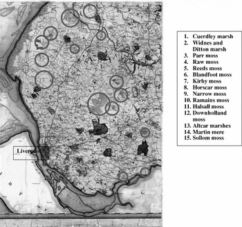
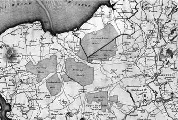
As we shall see, this was perhaps a naïve view. If there remained much to be done in 1843, this was due to the magnitude of the task rather than the indifference or inertia of previous generations. The mossland was very widespread: Trafford Moss and Chat Moss dominated the landscape on the western edges of Manchester; Rainford and Knowsley mosses were to be found further west. Much of south-west Lancashire was dominated by a succession of inter-connected mosses (figure 1), and the Fylde coast north of the River Ribble was dominated by mosses at Cockerham, Marton, Pilling, Rawcliffe, Stalmine and Winmarleigh (see figure 2).Footnote 16 In the 1790s the area of mossland in Lancashire was estimated at over 26,500 acres with a further 82,000 acres of moors, marshes and commons.Footnote 17
Moss and marsh in south-west Lancashire indicated on Greenwood's map of Lancashire, c. 1818. http://www.lancashire.gov.uk/environment/oldmap/greenwood/greenwood.htm. Reproduced with the permission of the Lancashire County Archivist.

Moss and marsh in the Northern Fylde district indicated on Greenwood's map of Lancashire, c. 1818. http://www.lancashire.gov.uk/environment/oldmap/greenwood/greenwood.htm. Reproduced with the permission of the Lancashire County Archivist.

This article is not an industrial archaeology of drainage technology providing a blow-by-blow account of every ditch and sluice gate in west Lancashire. Such an account would serve little purpose. Indeed, the basic technological approach to drainage altered little until the nineteenth century when the inadequate outfall in the drainage channels was given a mechanical boost. The article is more concerned with the administrative framework within which successive drainage schemes were organised. The first section focuses on drainage activity up to the late eighteenth century, looking at piecemeal improvements, the precarious nature of private agreements, and the failings of Commissions of Sewers. The second section discusses the heightened interest in drainage during a period of rapid development in the agrarian economy in the late eighteenth century when numerous large-scale schemes were initiated by landlords and private investors. This section also discusses the social tensions and economic consequences of a new administrative body introduced by the 1779 Act for Draining, Improving and Preserving the Low Lands in the Parishes of Altcar, Sefton, Halsall and Walton upon the Hill.Footnote 18 It is clear that the drainage commissioners initiated a programme that produced tangible benefits, but as a body with statutory powers they were not popular amongst the landowners and after initial success the maintenance of the drainage scheme fell into abeyance in the early nineteenth century. The long–term solution, discussed in section three, came about in the 1840s when the estates began to take drainage more seriously and invested in technology that was to reap rich rewards in the second half of the nineteenth century. The conclusion discusses the importance of drainage to the agricultural revolution in west Lancashire.
- I -
The farmers and landlords of west Lancashire were involved in a protracted battle to adapt the environment for the purposes of intensive agriculture, yet the area's ecological and topographical characteristics inhibited the capacity of a technologically primitive society to effect permanent improvements. Much of the mossland was below the ten metre contour, and frequent inundations of both fresh and salt water caused widespread losses. The inadequacy of the natural drainage system and the apparent futility of maintaining that system were reported in 1648:
The townes of Sephton, Male, Lunt, Thornton, & part of Alkar that did scoure have lost theire labour, & lost their grass, Corne & all, many of our neighbourhood are driven out of theire grounds by water most p[ar]t of this yeare, & have neither meddow ground, nor pasture for their cattle but have driven them to the Comons, to eate heath or starve.Footnote 19
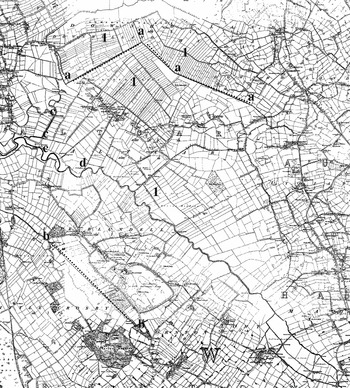
There was a further obstacle to the drainage and reclamation of this large area: the absence of effective management, organisation and administration capable of maintaining and augmenting the natural drainage channels. Indeed, although the ownership of the commons and mosses had been firmly established in an earlier period, manorial and township boundaries often cut through the wetlands (see figure 3).Footnote 20 It is no accident that ecological areas do not fit neatly within the boundaries of individual farms, manors, townships, parishes or estates, and this may reflect the economic value of the undrained mossland as summer grazing.Footnote 21 Nevertheless, any piecemeal attempt at improvement had to contend with the frequent lack of cooperation of neighbouring owners and occupiers. With the single exception of Thomas Fleetwood's ambitious attempt to drain Martin Mere in the 1690s, drainage in Lancashire was carried on without recourse to parliament until the later eighteenth century.Footnote 22 The majority of the drainage activity in Lancashire up to the middle decades of the eighteenth century was carried out in one of three ways: first, piecemeal improvement by individual occupiers; second, drainage programmes conducted under the auspices of Commissions of Sewers; third, private agreements between estates. Although there is widespread evidence of the existence of these methods of drainage, it is impossible to measure the scale of this activity either in terms of absolute acreage involved or in the comparative extent of one method versus another. Nevertheless, it can be said with a fair degree of confidence that these attempts at drainage were largely ineffective.
Altcar and surrounding area. The river Alt runs north west through the middle of the map, starting in the south-eastern corner, and formed the boundary between Altcar and Ince Blundell. The lines a-a and b-b indicate the boundaries between Altcar and Downholland and between Ince Blundell and Little Crosby respectively, both of which cut through the wetlands. The areas marked 1 indicate areas of piecemeal enclosure and improvement in the seventeenth century. The points marked ‘c’ indicate the location of flood gates and ‘d’ marks the location of the 1840s pumping station at the intersection between the river Alt and the main sluice. There are few contours on this landscape, with the majority of the land being less than 10 m above sea level. http://www.edina.ac.uk First edition O.S. map of Lancashire and Furness. © Crown Copyright and Landmark Information Group Limited, 2007. All rights reserved. (1847–1849)

Average farm size in west Lancashire was around thirty acres in the seventeenth century and although such farmers may have benefited from the piecemeal improvement of small areas of moss, this was carried out with primitive technology and little capital. Nevertheless, attempts were being made and even in the seventeenth century improvement was clearly driven by agricultural expansion and increased market opportunities. Although the rural population was static, the development of Liverpool as a centre of population, wealth and trade, acted as a stimulus for change after about 1650. The large Molyneux estate in south-west Lancashire made a clear distinction between ‘improved’ moss and ‘unimproved’ moss and the leasehold contract books show that in the periods 1649–1670 and 1680–1697 about 1,300 acres of mossland was enclosed, usually in individual strips of one or two acres (see figure 3).Footnote 23
Draining the mosses depended upon an expanding network of ditches and watercourses and, despite some limited use of bush drains, this basic technological approach did not fundamentally alter until the nineteenth century. But the new channels could do little to overcome the absence of a significant outfall from the mosses to the sea. Much of west Lancashire is only a few metres above sea level, and the currents in the watercourses were insufficient to ‘scour’ the river beds or man-made ditches naturally. The coast was protected by dunes, but periodic inundation from the sea caused the watercourses to silt up still further and sometimes left large areas of land under water for months at a time. Even as late as 1843, the Molyneux estate saw fit to employ a manorial superintendent of watercourses in Altcar at the annual salary of forty pounds.Footnote 24
According to John Holt, author of Lancashire's General View, the ditches themselves, and the piecemeal enclosure of small plots of land, became a problem that inhibited agricultural progress by the 1790s:
Many parts of the county are very flat and wet, such consequently require good ditches; from this has arisen the multiplicity of ditches, and from that cause neglect . . . At present, most of the ditches are nearly navigable, and no attention paid to gain an outfall, so that they are full of putrid water, and are a perfect nuisance. Many hundreds acres of excellent arable and pasture land are sacrificed to this stupid rage for small inclosures. I believe they may be of service in keeping up the breed of water-rats, but I know of no other advantage to society arising from them.Footnote 25
Holt went on to suggest that the ‘obstinacy of an adjoining neighbour’ could be a serious obstacle to agricultural improvements, observing that a tenant might be ‘disposed to drain his lands, but cannot effect this without the concurrence of a second, or probably a third and fourth, to assist in scouring ditches, opening water courses, and obstructions to the drains intended’.Footnote 26 Although large numbers of people were presented at Manor Courts charged with not scouring their ditches, the lack of an effective organising body limited the success of any attempts at drainage.Footnote 27 The Manor Court was simply not a powerful enough institution to coordinate the drainage of a large area of low-lying mossland that covered several manors, even if the owners of those manors had come to formal agreements about drainage.
The improvement and drainage of the mosses of west Lancashire was, therefore, in the hands of a large number of tenants who had little sense of their collective responsibility. Individual tenants may have demonstrated an ‘improving’ mentality through the enclosure, improvement and drainage of small plots of land over which they had exclusive rights, but they were not capable of improving the agricultural system of a region, nor could they compel neighbouring farmers to cooperate. The estates facilitated and encouraged these improvements, but lacked the will or the ability to organise a widespread drainage scheme. Lasting and significant improvements were never likely in an ecological system that did not recognise estate boundaries, and in which drainage and improvement was piecemeal and uncoordinated. The mutual dependence of the occupiers led to dispute and litigation. In an early eighteenth-century disagreement between the inhabitants of Ince Blundell and Little Crosby, it was argued that ‘for some years past’ the townships ‘have suffered much damage and loss by their lowlands being frequently overflowed and drown'd occasioned (as supposed) through defects and insufficiencies of their sluces, platts, watercourses and other outlets and passages’. The drainage ditches were vital to both communities, but as they crossed the boundary between the two townships, maintenance needed to be coordinated not only between tenants of the same estate, but by tenants of different estates. This social dimension of drainage coincided with the constant frustration caused by the environmental context. In this case it was also reported that ‘The said watercourse hath very often especially of late yeares been sanded or blown up by the high winds and the breaking of the sand hills . . . by reason whereof the grounds adjacent have been dammished’.Footnote 28 The task for the improvers, therefore, was simultaneously to conquer the challenge laid down by the topography whilst also overcoming the social tensions. Without recourse to adequate technology the first was not within their grasp, but in order to overcome the second, articles of agreement were drawn up in 1713 to ‘resettle and restore their ancient neighbourly friendship’ and to ensure the future maintenance of the drainage system. The first clause of this agreement was that ‘all controversies and suits at law or in equity be dropt and layd aside’.Footnote 29
Small-scale private enterprise and piecemeal improvement were never likely to deliver lasting improvements that had a perceptible impact on the wider environment. Yet the drainage programme was not entirely devoid of a wider organising body. In accordance with state intervention in drainage elsewhere in England in the seventeenth century, Commissions of Sewers periodically operated in south-west Lancashire, being set up in 1608, 1660, 1677, 1695 and 1771.Footnote 30 In theory the Commissions of Sewers only had responsibility for maintaining tidal rivers, and, as the Alt was the only tidal River between the Mersey and the Ribble, the potential impact on the drainage of the wider region was very limited.
Despite the theoretical limitations on the area of jurisdiction, the Commissions of Sewers did assume some responsibility for overseeing and coordinating drainage independently of individual tenants and landlords. The relationship between the Commissioners and the owners and occupiers of the low lands fluctuated. In the late 1640s the owner of a small estate in Crosby, Robert Blundell, recognised the necessity of the Commission to raise funds and coordinate drainage schemes across estate boundaries. Blundell argued that new enclosures, and the improvement of the moss by neighbouring tenants, had ‘greatly increased the fresh wat[e]rs’ on his land, effectively transferring the problem across the boundary. Blundell desired to see ‘all those p[er]sons that have inclosed . . indited for the newsance’, believing that ‘a legall course must bee taken to force all p[er]sons to doe there p[ar]ts w[hi]ch can bee noe otherwaise but by a Commission of Sewers’.Footnote 31 However, the Commissioners often proved to be powerless and they found themselves in dispute with the estates and with tenants, unwittingly encouraging and galvanising solidarity in opposition to their activities amongst the tenants and occupiers of the area. The disputes appear to have been particularly acute in the 1690s. A number of tenants whose land adjoined the River Alt had failed to maintain their drainage ditches yet they argued that the Commissioners had no jurisdiction to ‘order persons to scour the river adjoining to their land’. They further suggested that the maintenance of the ditches was the responsibility of the Commissioners who ought to levy a tax upon all the occupiers and hire workmen to carry out the work.Footnote 32 The dispute was still ongoing two years later, when several tenants, who had been named in a previous court order, set up a combination to defend litigation jointly.Footnote 33
The general ineffectiveness of the Commission of Sewers in the 1690s probably explains why there was no subsequent Commission until 1771. Indeed, when the petition was drawn up in favour of a new Commission in 1770, the petitioners referred only to the Commission of 1660, not to either of the intervening ones.Footnote 34 There is evidence of private agreements between estates in the first half of the eighteenth century but it is impossible to judge their general effectiveness in terms of the reclamation of the wetlands.Footnote 35 In the 1720s Nicholas Blundell regularly met with his neighbour, Lord Molyneux, to discuss drainage although a draft agreement between the estates in 1760 suggests that cooperation had declined leading to the neglect of the drainage system.Footnote 36 After a century and a half of schemes, agreements, Commissions of Sewers and small scale private enterprise, lasting improvements were not in evidence. In her wide-ranging survey of drainage in the Alt level up to 1779, Alison Maddock says little about the success of the various schemes, simply concluding that ‘at all dates works have proved of variable effectiveness’.Footnote 37 However, the failure of any organising body to coordinate drainage and ensure its long-term effectiveness, and the frequent disputes that followed the shaky private agreements, indicate that any improvements were merely temporary and much of the mossland was no more suited to intensive agricultural production in 1770 than it had been in 1570. Nevertheless, following these successive failures, and in the context of a prospering regional economy, the motivation and pressure for effective drainage mounted from the middle decades of the eighteenth century.Footnote 38
II
Even by the late eighteenth century, neither the estates nor the tenants were demonstrating the will to organise drainage and land improvement on a large scale. Piecemeal attempts at drainage were never likely to yield permanent benefits, private agreements led to dispute, and Commissions of Sewers had largely failed. However, even with the primitive technology that was deployed, large scale, capital-intensive drainage schemes under the jurisdiction of single individuals enjoyed a measure of limited success. Most famous of these ambitious, single-handed projects was the draining of the shallow lake of Martin Mere.
Martin Mere covered an area of around six square miles and the mere, along with the surrounding moss and marsh, was a formidable natural barrier.Footnote 39 Before drainage it was of little use as agricultural land except as summer grazing, although it was extensively used for fishing and fowling.Footnote 40 A lease was acquired by William Fleetwood in 1694 for the purpose of draining the mere. This lease gave him exclusive rights over the mere and was ratified by an Act of Parliament.Footnote 41 Shortly afterwards he began constructing a canal sluice twenty-four feet wide and over one and a half miles in length from the mere to the sea.Footnote 42 Deposition evidence from the early eighteenth century suggests that drainage was beginning to have an effect by 1697.Footnote 43 However, the scheme became a constant battle between draining the land of fresh water and stopping the sea from either flooding or silting up the canal. Fleetwood's success was restricted by technological limitations and a combination of investment in drainage and ensuing law suits led to severe financial hardships. Fleetwood died in 1717 although the lease did not expire until 1750 when the mere reverted to the proprietors. Within a few years the flood gates had been washed away, and although they were rebuilt at the expense of the proprietors, the drainage system fell into a neglected state and remained so for three decades.Footnote 44
In 1781, Thomas Eccleston took up the challenge. He acquired leases for those parts of the mere that he did not own and set about the task of drainage. Eccleston had the benefit of other large-scale civil engineering projects on which to draw, and employed John Gilbert, who had previously worked on the Bridgewater canal.Footnote 45 The drainage remained dependent upon ditches, sluices and flood gates, yet the scheme showed some success. Over one hundred miles of ditches were cut by draining plough, feeding into a main sluice that was five miles in length. By 1785 Eccleston was able to plough ‘nearly 200 large acres’ for oats and barley, using other parts of the mere for grazing and meadow.Footnote 46 Eccleston was awarded a gold medal for his achievements by the Society for the Encouragement of Arts, Manufactures and Commerce.Footnote 47
The limited success of Fleetwood and the much-publicised efforts of Eccleston indicated what could be achieved by committed individuals with the ability to act with autonomy. With capital to invest and jurisdiction over large areas, they demonstrated the potential of coordinated effort even though the technology remained primitive. Moreover, where these pioneers led, others followed in a series of large scale drainage projects overseen by individuals with exclusive rights in either the freehold or leasehold. As Holt put it in 1795, ‘There has been much draining done in many parts of the county; but there remains much to be done; but the spirit is gone forth, and the good effects are evident’.Footnote 48 In the 1770s the Duke of Bridgewater began the process of reclaiming parts of Chat moss, continued by William Roscoe and his partners in the 1790s.Footnote 49 John Chorley began the reclamation of part of Rainford moss in 1780 after acquiring a lease from the Earl of Derby for the purpose.Footnote 50 Improvements and drainage had also been carried out at Bootle marsh near Liverpool and at Warton moss in the Fylde.Footnote 51 Wilson France reclaimed part of Rawcliffe moss in the 1830s. At the same time as this mossland drainage, there were several other schemes underway to reclaim salt marsh along the Ribble and Lune estuaries.Footnote 52
These widely publicised efforts of individuals and syndicates may not be characteristic of drainage programmes more generally and were still not on a sufficient scale to secure permanent benefits. Nevertheless, collectively they indicate the dawn of a new improving culture and entrepreneurial spirit amongst the landowners of west Lancashire. Agricultural improvement was now seen as something that was not simply desirable, but achievable. Moreover, the continued growth of the market and the development of the transport infrastructure provided the potential to reap the financial rewards of investment. Fleetwood may have been foolishly ambitious and financially imprudent in the late seventeenth century, but the improvers of the late eighteenth century were operating under very different economic conditions. It is within this context that the management of the Alt drainage scheme acquired a new organising element after the passing of a drainage Act in 1779. The petition of Lord Sefton, local Member of Parliament Wilbraham Bootle, and other local landowners in support of the Bill was read in the House of Commons on 20th January 1779.Footnote 53 They were primarily concerned with the damaging effects of flooding on estate income. However, this petition was given extra support the following week by a second petition from Liverpool's civic authorities:
Saving the produce [of the lowlands] from Loss by frequent Inundation would tend not only to the Prevention of very great Damages to the Land Owners and Proprietors, but would be of public Utility, as the same Lands lie in the Vicinity of Liverpool, and such Casualties have the greatest Effect to raise the Markets thereof, more especially the Price of Hay.Footnote 54
The Bill was presented to the House of Commons on 25th February 1779 by a Mr St. John.Footnote 55 Less than a month later, Bootle reported that ‘the Parties concerned had given their Consent to the Bill’ except for the proprietors of 325 acres. These dissenters were clearly disregarded although several amendments were made to the Bill before it was passed on 22nd March 1779.Footnote 56 The Act introduced Drainage Commissioners who were charged with the responsibility of draining the land and given the power to levy a tax for the purpose.Footnote 57 As an administrative body they had greater powers than earlier Commissioners of Sewers, but crucially they also had the support of the local landed elite, at least initially. The Commissioners themselves were not allowed to have any interest in the low lands and the first Commissioners were mainly gentlemen and rural vicars from surrounding parishes, although one was a Liverpool merchant.Footnote 58 The Commissioners’ jurisdiction extended over 4,900 acres, thirteen townships, several landowners and several hundred tenants.Footnote 59
Much of the following account of the operation of the 1779 Act is based upon an account published in 1850 by Edward Littledale, a Liverpool solicitor. At the time of publishing this book, Littledale was the secretary to the Drainage Commissioners and the book was largely based on the detailed minutes of the Commissioners’ meetings. As secretary to the Commissioners, Littledale may have been a biased witness, although this source is supplemented by independent estate records. The actual minute books for the period before 1801 have not survived, so Littledale's reporting for the first two decades cannot be verified. However, comparison of Littledale's account with the surviving minute books for the period after 1801 indicate that he faithfully reported on these records.Footnote 60
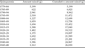
Table 1 shows the amount raised for drainage in the period 1779 to 1848. Within the first five years of the Act, over £5,000 was raised for drainage. A further £5,000 followed in the 1790s and by 1848 over £26,000 had been raised since the passing of the Act. Although the cost was widely spread, the Act was an essential enabling device. It allowed Commissioners to tap into reserves of capital that were otherwise unavailable for large-scale fixed capital projects. The methods used were fairly primitive and they did not seek a mechanical solution, preferring to invest in a combination of flood gates, new cuts, sluice gates and the removal of some of the meanders from the river Alt. Initially the success was limited, but by the 1790s the drainage scheme was beginning to have an effect. It was claimed that by 1791:
the lands, in the greatest part of Altcar, and in the north part of Formby seemed to have been improved in the greatest degree; those in Sephton, Netherton, Aintree, Melling, and Maghull in the next proportion; whilst those in the north part of Altcar adjoining to Downholland, Downholland itself, Ince-Blundell, Lunt, Thornton, Little Crosbie, and the south-west part of Formby appeared to have received benefit in a still smaller degree.Footnote 61
Moreover, two to four shillings had been added to the value of each customary acre in Altcar and Formby.Footnote 62 Arable production was also expanding on this land, and some tenants allegedly:
ploughed the ground almost close to the river side, and thereby weakened, and lowered the banks, and kept the soil loose, by which the banks were in danger of being washed away, shold [sic] a flood at any time rise to near the top, which would then wash them down, and inevitably overflow the country.Footnote 63
Amount raised for drainage under the auspices of the 1779 drainage Act, 1779–1848

Source: E. Littledale, Abstract of an Act of Parliament . . . and some facts (taken principally from the minute books of the proceedings of the commissioners) showing the commencement and progress of the works up to the present period, Liverpool, 1850, p. 158.
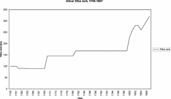
It is impossible to measure directly the acreage of land successfully drained and the incremental progression of the gradual lowering of the water table. Indeed, it is not easy to determine when land can be classified as ‘drained’, although indicators of changing productivity on this land are available. Figure 4 shows the annual value of the Altcar tithe rent between 1755 and 1807. If tithe rent can be taken as a proxy for agricultural productivity, there was a period of marked progress after 1799. Rising agricultural prices were partly responsible for some of the increase in the tithe rent. Nevertheless, by 1807 tithe rent had almost reached two shillings per acre in Altcar, double that of a decade earlier, showing that drainage was having a perceptible effect on land productivity. Between 1779 and 1799 the annual value of the low lands in Altcar covered by the act had increased by forty-six per cent to £2,415. Between 1799 and 1806 the annual value increased by 106 per cent. The annual value of the total land area covered by the Act increased by thirty-two per cent in the two decades to 1799 and by 110 per cent between 1799 and 1806.Footnote 64 Although inflation would account for some of this, it was argued that ‘these low lands were, before the drainage, incapable of improved cultivation, or of any safety of their crops. And it is, therefore, the works of the drainage, principally, which have given to these low lands a capacity of improvement, and capability of encreased rents’.Footnote 65
The annual value of the Altcar tithe rent, 1755–1807.

Despite the effectiveness of the drainage, the Commissioners were not popular, and the estates were reluctant to acknowledge their jurisdiction. From 1791 onwards the activities of the Commissioners were questioned and criticised by the estates and their representatives. The work was proving to be expensive to the landowners and occupiers and although by 1794 it was said that ‘the lands in Altcar had received very considerable benefit from the works’, they were ‘still liable to be overflowed’.Footnote 66 In February the following year the tenants of Altcar, Downholland and Formby were themselves complaining that ‘notwithstanding the works already done, the lands in Altcar, and those places had been [sic], in that winter, much overflowed, and still so continued’. In response, the Commissioners ordered the tenants to repair their defective ditches and other watercourses.Footnote 67
The landowners railed against the works of the Commissioners, and evaded financial contributions. As early as August 1794 it was suggested by some landowners that ‘the works had been completed and finished’ and that future work should be restricted to repairs only, at the expense of the occupiers only, in accordance with the Act. The Commissioners disagreed, pointing out that new flood gates and other new works had been done using £300 of borrowed money. When the next assessment was made on both the landowners and occupiers, appeals were submitted by all the major landowners or their agents on the grounds that the work had been finished. The appeals were unsuccessful and the landlords were compelled to contribute.Footnote 68
The landlords were persistent and in February 1797 the Molyneux steward refused to pay the rate.Footnote 69 At the same time, the tenants and occupiers of the low lands also claimed that the works should be certified as complete. A meeting was held in May 1797, attended by several ‘owners and occupiers of different parts of the low lands’. It was decided that the works were not completed and when the next tax was levied in June 1797, all the landowners appealed. The Commissioners were unimpressed. It appeared to them that ‘the works carried on and then in prosecution were for the manifest advantage and interest of the owners and proprietors of the low lands’. They were convinced of ‘the necessity, and utility of the works, and the great benefit, and advantage to the owners, and occupiers’. Accordingly they ‘ratified, and confirmed the rate, and assessment’.Footnote 70 The owners and occupiers then appealed to quarter sessions. During the subsequent investigation, it emerged that the Commissioners had not been following the directions of the Act when determining the rate. The wording of the Act in respect of how assessments were to be made is certainly not clear. On the one hand the Commissioners were directed to ‘assess, rate, tax, and charge all and every the several and respective owners and occupiers of the low lands, according to their several estates and interests therein, at such annual acre rate or tax as they shall think proper’. However, the same clause of the Act makes several references to the value of the land, and the proportionate benefit to be derived from drainage. Indeed, the Act states that ‘the low lands will, upon the draining thereof, receive improvement in different degrees and proportions; and it is reasonable that they should be taxed towards the expenses aforesaid, in proportion to the improvement they will so respectively receive’.Footnote 71
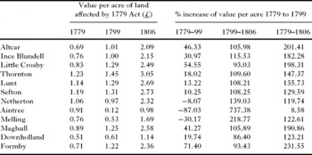
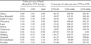
This naïve wording, undoubtedly reflecting the lack of experience of drafting legislation of this nature, clearly left room for dispute. For eighteen years the commissioners had based the assessments on the annual value of the land, rather than a tax per acre, as was directed by the Act. According to Littledale, the higher and drier lands had paid a greater proportion of the tax per acre due to their comparative safety from flood and hence a higher value before the Act. Conversely, the lands which benefited most from the drainage were those that contributed least. Nevertheless, such is the ambiguity of the wording in the Act that those areas that were more prone to flooding ought, if anything, to have contributed more per acre, as it was this area that was most likely to benefit from the drainage works. The evidence provided by Littledale certainly shows that there were wide variations in the annual value of the lands affected by the Act, ranging from ten shillings per acre in Downholland to twenty-five shillings per acre in the drier land in Thornton. Littledale also shows that in general the land with the lowest value per acre in 1779 benefited most from the drainage works in the period up to 1806 (table 2).
Value per acre of land affected by 1779 Alt drainage Act and the percentage increase in annual value, 1779–1806
Source: Littledale, Abstract, pp. 155–6.
Once the ambiguity of the language had been raised in quarter sessions in 1797, it was clear that all previous assessments had been illegal, and the 1797 assessment was quashed with the legal costs of both sides being charged to the rates under the Drainage Act.Footnote 72 This was probably a small price to pay for the landlords who undoubtedly viewed this as a major victory. Although they levied future rates in accordance with the Act, the Commissioners were on the back foot. In 1798 they initiated an enquiry to determine whether the drainage works were completed, ‘so as in future to require only repairing and preserving’.Footnote 73 They decided that the works were not finished, but in 1799 further appeals were made. The occupiers of the low lands in Ince Blundell, Little Crosby and Altcar petitioned against continuance of the works and the major landowners complained of the ‘improper expenditure of money’ by the Commissioners.Footnote 74 Littledale does not show how these petitions and letters of complaint were received by the Commissioners, but after several years of legal wrangling and opposition, this may have been the final straw. During 1799 the Commissioners undertook a full survey of the works, and received the opinions of engineers and surveyors. Although the works were not found to be perfect, at a meeting of 15th April 1799 the Commissioners decided that ‘although the works might be made more commodious for the purposes in the Act mentioned, yet that the same, as they now are, are effectual for the purposes intended’. There was considerable difference of opinion amongst the Commissioners, but six of the eight agreed to sign the certificate to confirm ‘That the works . . . have been completed and finished’.Footnote 75 This certificate prevented new work, restricting future efforts to maintenance and repairs, exempting landlords from future assessments, and placing the burden fully on the occupiers.
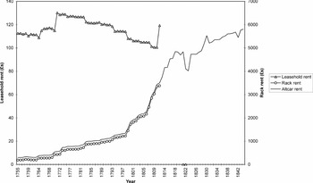
Immediately after the Commissioners issued this certificate, rents began to rise dramatically. They had initially begun to rise in 1799 and 1800, when the landlords were arguing that drainage had been completed. Indeed, total Altcar rents increased by 16.4 per cent in 1799 and 17.8 per cent in 1800. In nearby Kirkby, also on the Molyneux estate, closer to Liverpool, but not covered by the Drainage Act, rents increased by 1.8 per cent and 6.6 per cent in the same years. The Molyneux estate recognised that significant improvements had been made, and that land productivity had increased, and they manipulated this in order to persuade the Commissioners to issue the certificate. Once the certificate had been issued, rent increased very rapidly until the depression of the 1820s halted the trend (see figure 5).
Altcar rents, 1755–1844.

The Commissioners undermined the authority of the estates. They had the power to force landlords to pay for improvements on their estates over which they had little or no control. One such measure, instituted by the Commissioners in 1797, was the reclaiming of the mud flats at the Alt estuary by the planting of gorse faggots along the shoreline. The drifting sands were causing the river channel to silt up, and it was hoped that trapping the sand would raise it above sea level and improve the flow in the channel. Nevertheless, whilst this may have been prudent from a civil engineering point of view, it did not meet with the approval of some proprietors. The sentiments of the landlords were captured in a letter from Blundell to the Commissioners written in October 1798, at a time when the landlords were gaining the upper hand. It is worth quoting at length.
I was obliged by your attention in communicating me the report of the Comm[issione]rs for the Alt Drainage, it is the first piece of civility of the kind, I have ever rec[eive]d from those meetings. As you may be a stranger to my sentiments as well as to those of all or most of the landowners, on those works carrying on long by the shore, it may be proper to acquaint you, that they were begun and carried on for some time without our knowledge, consent, or approbation, and I believe there is not a landowner who would not with one rejoice to hear that these works were destroy[e]d and wash[e]d away by a rough spring tide, so much we all disapprove of them . . . It may be presumed that some of the landowners may be as capable of judging what is for their own good as the comm[issione]rs or their engineers who are interested in such works, where these works entail an endless expence to the country . . . I cannot conclude without making a remark on the great improvement puffed of in the report, w[hi]ch I think is far from being the case, to judge of these improvements they sh[oul]d have know[n] the condition of the lands before these works & how they set before . . . they can be no judges of the improvements, of this the landowners are certainly the best judges.Footnote 76
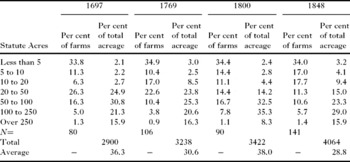
Despite Blundell's claims that there had been no improvements, this can hardly be the case. Although rents and tithe rents were increasing dramatically, tenants were eager to acquire land in the low lands at inflated rack rents. Average farm size altered little in the last third of the eighteenth century, but the numbers of large farms and very small farms were increasing as the communities became increasingly socially polarised (see table 3). It was the outside interference that was disliked by Blundell and the other landowners. The tenants also disliked the authority of the Commissioners. They felt burdened by the rates and felt better able to manage the maintenance and repairs without the coordinating body of Commissioners. After the landlords acquired exemption from paying the rates, the tenants became anxious to gain control of the works. The Commissioners, however, were obstinate:
Farm size in Altcar, 1697 to 1848.

Source: DDM 14/9 Altcar survey, 1697; DDM 14/12 Altcar survey, 1769; DDM 14/14 Altcar survey, 1800; DRL 1/4 Altcar tithe schedule, 1848.
Notes: No estate survey survives after 1800. The tithe schedule was obviously generated for different reasons than the estate surveys and may not be directly comparable. Thirty-two individuals holding less than one acre in 1848 have been excluded from this table. The total acreage progressively increases as more land was enclosed and taken into cultivation between each survey.
It has been said that as the works are finished the occupiers are competent to do it at less expence but the attempts that were made & had failed, before the Act of Parliam[en]t was obtained, shew the fallacy & danger of trusting important measures to disunited efforts. Some occupiers might think it their interest to do there part as cheaply as possible, others would be apt to neglect it altogether, some might wish to do the work completely, but there w[oul]d be no jurisdiction by which others could be compelled to conform to those endeavours. It would be the provence of no one to watch over and protect the Flood-gates & sea banks, which being once neglected w[oul]d occasion the destruction of the whole. Everything must necessarily go to confusion, and at last it would be found prudent to form a committee of management, for the general interest of the whole. The present commissioners are already that committee of management with full legislative authority for every beneficial purpose, and not being permitted to possess an interest in the Low Lands, are the more independent and disinterested in there proceeding. The expences of management are certainly considerable, but they bear no relative proportion to the good which it has achieved & which it is now the great object to protect.Footnote 77
The Commissioners were convinced of the efficacy of the drainage scheme. They repeatedly observed that considerable improvements had been made. Yet, they too objected to the interference from others. In 1802 they declared that ‘The commissioners seem all of opinion that what they are doing is for the public good – And that it would be the extreme of Pusillanimity, not to say Imprudence, to resign what they are answerable for themselves into the hands of others’.Footnote 78
The Commissioners, therefore, retained the authority to oversee the maintenance of the drainage scheme, and continued to levy a tax on the occupiers for that purpose. However, the maintenance of the system was beset with problems. By 1811 the flood gates at the mouth of the River Alt were in a ‘ruinous condition’.Footnote 79 James Edwards, the Commissioners’ engineer, wrote to the Commissioners on 16th May 1811 to explain that ‘the present old gates are in a very decayed state, and insufficient for the purpose for which they are intended’.Footnote 80 He recommended a ‘very temporary repair’, and gave an estimate for a more thorough repair of £2,500. In the long term he suggested that new floodgates should be built, at a cost of £3,100.Footnote 81 The Commissioners chose to repair the existing gates at a fraction of this estimated cost spending just £174 on repairs and mistakenly believing that the floodgates ‘were likely to last 40 or 50 years’.Footnote 82 This was clearly ambitious. Repairs were carried out in 1818 and the following year the carpenter who had carried out those repairs reported that the gates were ‘rotten’. In 1819 it was reported again that the ‘flood gates were in a defective state’.Footnote 83 Repairs carried out in that year amounted to £23 but by 1829 it was said that ‘the flood gates themselves were in the most inefficient, not to say, dangerous state’.Footnote 84 Indeed, the reports of Jesse Hartley, appointed by the Commissioners to survey the works, were very critical of both the drainage works, and, by implication, the management provided by the Commissioners: ‘I cannot avoid stating, that, considering the whole to be under constant inspection, I never witnessed greater neglect’.Footnote 85 Hartley recommended that ‘a cottage ought to be erected in which should reside a steady, operative man, whose employment should be mixed up with nothing but the manual operation of giving full effect to the whole of the drainage’. The Commissioners immediately approved the suggestion, although the ‘diary showing what labour had been daily expended, on what particular spot, and for what purpose’ seems not to have survived.Footnote 86
The river and the new channels had gradually silted up, and without a considerable flow of water to ‘scour’ the river bed, the existing works were failing. Significantly, the landlords themselves began once again to intervene in the drainage programme, but in a much more cooperative way than they had two decades earlier. In July 1823 the Molyneux estate along with the Blundells of Ince and the Blundells of Crosby applied to the Commissioners for permission to dig a cut of their own. The Commissioners ‘assented, . . . it being understood that they do it at their own risk, and are to be responsible . . . for any injury to the general works which may arise in consequence’.Footnote 87 It is not clear how much success this scheme enjoyed but it does reflect a changing attitude of the proprietors towards drainage. This may have been a consequence of the significant rent arrears which had led to the Molyneux estate giving rent abatements, but the relationship between the Commissioners and the proprietors, and the willingness of the proprietors to contribute financially to the drainage works, had clearly altered considerably since the late 1790s.
Despite the fact that a new Act of Parliament was discussed in 1829, the Commissioners remained responsible for collecting the tax from the occupiers and overseeing repairs and maintenance of the existing works. However, the technology remained primitive, and the drainage scheme relied very heavily on open cut ditches, flood gates and a sea-bank. When the Molyneux estate began to seek more advanced methods of drainage in the 1830s and 40s, they did so without the aid of any outside bodies.
III
Mechanisation was to provide a solution to the long-term problem of draining these low-lying wetlands. By the 1830s the Molyneux estate was eager to learn of, and invest in, powered machinery for the more effectual drainage of the mosses of the Alt basin. In 1840 the steward had made enquiries about the practicalities of a locomotive steam engine for pumping water. He noted that several such machines were in operation in south-west Lancashire not only for pumping water, but also for churning and straw cutting. He was ‘firmly convinced of the utility – indeed . . . the immense advantage’ of this machine, and was eager to recommend it to the Earl of Sefton.Footnote 88 Although it was reported that the engine could raise 360 gallons of water per minute, competition between the estates was also an influencing factor. The Earl of Sefton was informed by his steward that ‘Lord Derby has not fixed about having one’.Footnote 89 In the same year a twenty horse power steam engine, for drainage and grinding corn, was discussed. The estimated cost of £2,150 caused the idea to be dropped.Footnote 90 The following year the Molyneux steward was making further enquiries about draining the Alt basin with the assistance of a windmill that was reputedly capable of pumping 5,000 gallons of water a minute. The estimated cost was under £1,000, although the estate did not propose to pay for this. Rather, the possibility of raising the capital through the means of ‘a proportionate levy’ under the 1779 Drainage Act was discussed.Footnote 91 The estate had requested the advice of one John Locking who was said to be ‘a person thoroughly conversant with . . . this description of work in Lincolnshire’.Footnote 92 The windmill was never built, possibly because, as Locking himself admitted, ‘windmills are going out of fashion, and steam engines a[re pre]ferred’.Footnote 93 The estate contacted several other engineers and various plans and models were submitted for consideration by the Earl of Sefton.Footnote 94 By April 1843 an engine had been constructed at Altcar at a cost of around £3,000 paid for by the Molyneux estate for the purpose of drainage, although it is not clear which engineer's plan was adopted (see figure 3).Footnote 95 After a severe downpour the engine was set to work and running at five-eighths capacity was raising between 4,000 and 5,000 gallons of water per minute. The Molyneux estate officers were in confident mood and were full of self-congratulation. It was remarked that Thomas Dalzell, the recently-appointed Scottish farm bailiff, ‘could not imagine there could be such good land in that part of the county’. William Eaton Hall, the estate steward, wrote the Earl of Sefton ‘that you may congratulate yourself upon the entire success of the undertaking’.Footnote 96 After further ‘torrents of nearly incessant duration’ three weeks later, the engine ‘was working very beautifully with apparent ease’ discharging about 9,000 gallons of water per minute. It had successfully lowered the water level by two feet in seven hours.Footnote 97 The drainage system was obviously enjoying some measure of success, which the estate was keen to acknowledge. In May 1846 the steward commented that never before had ‘the crops of any kind presented so promising an appearance as the present more particularly the parts which were accustomed to be flooded, and which would have been this year but for the engine’.Footnote 98
IV
The importance of drainage to the course of the agricultural revolution in west Lancashire cannot be overstated. Without continued investment the ‘magnificent soils’ would quickly revert to worthless swamp. In the nineteenth century food production in west Lancashire was vital to the economy of the North West. With a population of 2.4 millions by 1861, Lancashire could not be self-sufficient in food, but arable farming on former mossland was vital to the food supply of Liverpool, Manchester and other industrial and commercial centres. The drained land was capable of supporting very intensive farming, and railways were built to convey the produce to market.Footnote 99 But whereas it has been suggested that the transformation of Lancashire agriculture can be dated to the period after 1840, it is perhaps more accurate to argue that it was only in the period after 1840 that the benefits of an earlier developmental stage were reaped.Footnote 100 Central to this earlier developmental stage was drainage. Unlike enclosure, drainage was not a once and for all act representing a sudden discontinuity, but a process requiring constant investment, attention, maintenance and organisation. Drainage and reclamation was an ongoing and prolonged process which affected every individual with an economic interest in the area. Unlike in the fens in the seventeenth century, social relations and the rural economy were not subject to sudden and far-reaching change, and although the economy did not stagnate, the lack of an effective organising body hindered the process of land improvement until the late eighteenth century. Despite the ambitious projects of the later eighteenth century, the financial rewards of drainage were never likely to be realised in the short term although it is clear that there were considerable long-term benefits.
The key to success was in overcoming the two main obstacles: first, the inadequacy of the drainage technology being utilised, and second, the lack of an administrative body with the expertise and authority to organise. While the technology deployed remained primitive, the main emphasis was on the administrative arrangements, yet improvements carried out by individual tenants, private agreements and Commissioners of Sewers were limited and none of these constituted an effective management system. Individual pioneers with autonomous jurisdiction over large areas and the coordinated efforts of the Drainage Commissioners appointed by Act of Parliament showed the potential of what could be achieved. Nevertheless, the decision by the Molyneux estate in the 1840s to take responsibility for the drainage of a substantial area, deploying a technological solution to do so, was a radical step and a complete break with tradition. But it was, undoubtedly, a rational, measured step. By the 1840s it was clear that the ongoing processes of urbanisation and industrialisation were permanent features of the regional economy, and the stimulation to agricultural production and rising land values was well-established. The pioneers of earlier generations had demonstrated the potential benefits of drainage through their investment in risky ventures; the direct investment of the Molyneux estate in the 1840s can hardly be regarded as speculation. Indeed, their primary concern was permanently to secure the increased rental income that drainage had brought through the deployment of technology. The technology itself was not new and it is clear that they were only prepared to invest in tried and tested methods. Their brief flirtation with windmills was anachronistic, and they took the advice of engineers with experience of drainage in the Fens where wind power had been successfully applied to drainage for many decades. Nevertheless, steam power also had a proven track record in the drainage of mines and had been shown to be safe and efficient. As owners of coal mines, the Molyneux family, like other landlords in south-west Lancashire, would have been aware of this technology, and with a supply of coal readily available locally steam power was the logical permanent solution to a long-term problem.
The agricultural revolution in arable Lancashire was a fundamental part of the region's wider economic success from the late eighteenth-century onwards. Agricultural development is clearly multi-faceted. Nevertheless, it is apparent that without significant investment in drainage, which was only made possible by the effective deployment of capital and technology, Lancashire's agrarian regime would not have contributed as strongly as it did to the food requirement of urban industrial workers. The extent to which this is true on a national scale has yet to be determined and further work needs to be done on different regions and on land productivity before and after drainage. Only after the mid-nineteenth century is it possible to offer tentative figures for the acreage of agricultural land that was effectively drained. Robinson suggests that as much as 50,000 km2 (12.3 million acres), representing forty-five per cent of the agricultural land of England and Wales, benefited from underdrainage in the nineteenth century.Footnote 101 It is tempting to speculate that drainage was considered to be much more important to agriculturalists than it has hitherto been to agricultural historians. With considerable attention being given to enclosure, and in terms of drainage the focus being either the social consequences or the effects on the landscape, there is clearly a need to develop an understanding of the economic implications of drainage. Indeed, such an analysis is long overdue.