

Every door has two fronts, this way and that, whereof one faces the people and the other the house-god; and just as your human porter, seated at the threshold of the house-door, sees who goes out and in, so I, the porter of the heavenly court, behold at once both East and West.
(Ov. Fast. 1.103–40Footnote 1)The remains of the Ianus Augustus, a monumental boundary marker on the border between the provinces of Hispania Baetica and Hispania Tarraconensis, were found in the context of an analysis of the territory of Iliturgi and its ancient roads.Footnote 2 A multidisciplinary strategy including surface and geophysical prospections and excavations was developed to reveal the configuration and context of this monumental complex. The objective was to obtain empirical data on the Ianus Augustus with which to advance the current historiographic debate, which has generated different hypotheses regarding the monument's location and nature. The find of the Ianus has widespread repercussions on different analytical scales. On a regional level, its discovery will contribute to the debate on the location of the Via Augusta and the border between the provinces of Baetica and Tarraconensis. On the scale of the Roman Empire, it is an indicator of the scope of the Augustan territorial reforms and is one of the few known examples of capita viarum used as monumentalized boundary markers between two provinces.
Searching for the Ianus Augustus
With the establishment of the senatorial province of Baetica by the emperor Augustus in 27 BCE came the idea of endowing it with borders and its own concept of provincial space. For this purpose, the main road running through the whole of Hispania, the Via Augusta, was the ideal site for the Ianus Augustus. The Ianus was an arch situated where the province began,Footnote 3 near the Guadalquivir (Baetis flumen), in the context of a new road network that had a direct connection with the river itself. The Ianus was not only a milestone on the new road network but was also conceived as an important scenographic element representing the image of imperial power in the self-propaganda that Augustus projected throughout the new senatorial province.Footnote 4
The Ianus regulated the entire Via Augusta in the province of Baetica, as is demonstrated by the milestones from the periods of Augustus, Tiberius, Caligula, Claudius, Nero, and Domitian.Footnote 5 The road, the Ianus, and the River Baetis constituted powerful tools for monumentally and symbolically referencing this new administrative territory. The road would have acted as a focal point and a unifying element: despite running through the rest of Hispania, it acquired its own autonomous nature in the recently established province of Baetica.Footnote 6
No source other than epigraphy mentions the monument. Some 15 preserved inscriptions refer to the Ianus, ranging from milestones to inscriptions recording bridge repairs. The use of numerals on milestones to indicate distance is limited in the province of Baetica to the 1st and 2nd c. CE, from Augustus to Hadrian.Footnote 7 Even the way of referring to this caput viae differs depending on the date of the inscription:Footnote 8
– a Baete et Iano Augusto ad oceanum,Footnote 9 during the reigns of Augustus and Caligula;Footnote 10
– ab Iano Augusto qui est ad Baetem usque ad oceanum,Footnote 11 during the reign of Tiberius;
– ab arcu unde incipit Baetica viam Augustam militarem,Footnote 12 under Domitian.
The interprovincial border monument thus acted as the beginning marker for a stretch of the Via Augusta, with the ocean as its end. This indicated a particular understanding of that road segment, signifying its importance with reference to those two boundary markers and avoiding any mention of the towns to which it connected, among them the Colonia Patricia Corduba as the capital of Baetica.Footnote 13
The historiographic origins of the Ianus Augustus date back to 1532 CE, when excavations in the Great Mosque of Córdoba revealed two Roman milestones that alluded to its existence. The first person to transcribe them was Juan Fernández Franco, who suggested that the milestones had been part of a temple dedicated to the god Ianus located in the town of Corduba itself.Footnote 14 Later, Ambrosio de Morales agreed with this hypothesis, although placing the temple some distance from the mosque where the milestones were found.Footnote 15 Finally, Pedro Díaz de Ribas was the first to suggest that the texts probably indicated the existence of an arch.Footnote 16 However, the scholarly and literary analysis of the epigraphic documents between the 16th and 19th c. failed to elucidate the location and elements of the Ianus.
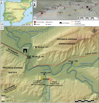
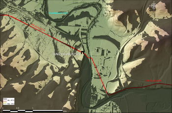
Those early scholars only had the epigraphy of the milestones to attempt to locate and define the Ianus. It was not until the late 19th c., during the preparation of the Corpus Inscriptionum Latinarum (CIL), that Emil Hübner systematized the information and introduced new documentation relating to the roads of Baetica, including an initial proposal for the location of the Ianus Augustus at the point where the River Guadalimar flows into the Guadalquivir.Footnote 17 A little later, the CIL cartographer Heinrich Kiepert, incorporating data by Francisco Coello, placed the Ianus Augustus on the left bank of the Guadalquivir. This location has served as a reference until the present day, for instance in the Tabula Imperii Romani (see Fig. 1).Footnote 18
Different proposals for the location of the Ianus Augustus before the recent excavation. (a) Within the provincial territory; (b) along the Via Augusta between Corduba and Castulo; (c) within the territory of Iliturgi. (Courtesy Iliturgi Project.)

Hübner was followed by other scholars who added new data, including Fidel Fita, who pointed out the need for new finds to determine the correct distances on the known itineraries, and Antonio Blázquez, who placed the Ianus at Cerro de las Huelgas, on the right bank of the Guadalquivir.Footnote 19 The absence of archaeological evidence and historical references for the Ianus Augustus meant that in the early 20th c. the approach to its location was more concerned with calculating distances based on the epigraphy than on archaeological surveying and analysis. This can be seen in the case of José Ramón Mélida, who pointed out that the monument was known historiographically but that there were no remains of it, stating: “This arch has not been preserved.”Footnote 20
Around the same time, Arthur L. Frothingham devoted The Roman Territorial Arch to the symbolic dimension of the arch as a monument in the landscape and a structuring territorial element in the Roman era. He pointed out the ambivalence of the Ianus, as both arch (arcus on the milestones) and significant boundary marker: “The boundary arches showed where it was permissible to pass. Elsewhere along the border line it was forbidden to pass. In early times the penalty for doing so was death.”Footnote 21
In the entry corresponding to the Ianus in the Real-Encyclopädie, Wilhelm Kubitschek explains its abandonment as the gateway to Baetica as the result of a correction in the route of the road itself.Footnote 22 Months before Pauly-Wissowa's publication, Louise Adams Holland gave a talk entitled “Ianus and the bridge,” a precursor to her magnum opus with the same title published in 1961, which has become a reference for this subject.Footnote 23 Holland devoted her investigation to the relationship between the god Ianus and the watercourses from the topographical point of view, based on the significance of the Temple of Ianus, the Ianus Geminus, in the Forum Romanum. Historical tradition tells us that the temple doors remained open during times of conflict and were only closed in peacetime. One of these closures was instigated in the year 2 BCE by Augustus himself (who is directly linked to our Ianus), within the framework of the Pax Augusta.
Although Frothingham considered the terms Ianus and arcus to be synonymous,Footnote 24 Holland specified that:
although the terms are not completely equivalent until the end of the classical period, they could describe the same monument. Thus, an Arch of Augustus next to the River Baetis in Spain and three arches erected in honor of Germanicus are described both as iani and arcus. However, whereas arcus describes a form, Ianus indicates a function and, in our belief, can only be applied to a gate (either lintel-like or with an arch) that marks a crossing point over the water.
When Augustus conceived the monument, he evidently pointed out the transitio pervia (transition of access) a bridge would have provided at that place. Subsequent emperors referred to the road, but omitted any mention of the river, the Ianus or an arcus.Footnote 25
Meanwhile, in Spain more general studies focused on the functions and typologies of this kind of monument or insisted on their symbolic aspects.Footnote 26 In one of the first studies, Pierre Sillières had already proposed a location for the Ianus in the area around Mengíbar, indicating a possible survival of its memory in the name “Venta del Arco” (Inn of the Arch).Footnote 27 Following Holland, Sillières linked the caput viae of the Via Augusta in Baetica to a monumental complex composed of an arch and a bridge over the River Baetis.Footnote 28 A short time later, he inspected the site in person, on the final stretch of the road as it approached the border with Tarraconensis, accurately identifying its route in the Camino de los Romanos, where he recognized part of its agger.Footnote 29 Moreover, a military route provided with many instances of the infrastructure needed to ensure the regular circulation of the couriers of the cursus publicus would have had a bridge.Footnote 30 Finally, in a 2003 study, Sillières once again emphasized the sacred nature of the monument, linking it to one of the first forms of worship of the living Augustus and considering it among the most important buildings in southern Hispania.Footnote 31 A recent proposal placed it next to the River Guadalbullón.Footnote 32
Ianus Augustus, Caput Viae
Our area of analysis is located at the junction of the Via Heraklea or Camino de Aníbal (Hannibal's Way) with the Via Augusta (Fig. 1). The former is considered to be an ancient road that reached its maximum splendor around the 4th and 3rd c. BCE, due to the important geostrategic role of the town of Castulo. It is known to have been used during Caesar's campaigns in 45 BCEFootnote 33 and would have coincided with the road known as Iter a Corduba–Castulone (Calpurniana, Urgavo, Iliturgi, Castulo),Footnote 34 one of the two roads described by the Antonine Itinerary.Footnote 35 An inscription reused in Bujalance Castle (Córdoba), identified as ancient Calpurniana by Ángel Ventura, recounts the restoration of “the Via Augusta, that runs from the arch to the ocean” and serves as an argument for identifying this southern stretch with the original from the time of Augustus, although the debate remains open, as Alicia Canto disputes the reading of the Bujalance inscription.Footnote 36 Here, instead, we defend a northern route based on the new archaeological arguments we present below.
There is another itinerary, known as Alio itinere Corduba–Castulone, to the north of the aforementioned one, whose route from Corduba cites the place names Ad Decumo, Epora, Uciense, Ad Noulas, and Castulone. This road, with slight variations, is also mentioned on the Vicarello Cups.Footnote 37 Its considerable technical complexity, with several bridges on its initial stretch close to Corduba,Footnote 38 its route almost parallel to the river, and the coincidence in the distances engraved on the milestones found in situ up to the Ianus Augustus, are the arguments put forward for identifying this road as the Via Augusta.Footnote 39
Nevertheless, as different authors have pointed out, aspects such as the possible historical variability of the roads, the difficulty of repairing them, and their abandonment due to complex social or political criteria should be taken into account.Footnote 40 From our point of view, and with the archaeological remains located, it is Sillières who has come closest to understanding the situation and function of the Ianus Augustus. Based on his vast knowledge of the Roman roads in Hispania and an in situ review and inspection of relevant areas, he correctly hypothesized its location and called for a suitable archaeological methodology.Footnote 41
The monument's status as caput viae is determined by different elements. The regional epigraphy does not mention another caput viae between Gades and the Ianus Augustus. The Neronian-period milestone found in Puerto de Santa María (close to Gades) establishes a distance of 222 milia passuum (Roman miles) to the frontier of Baetica as a reference for the beginning of its route in the province.Footnote 42 Moreover, the Guadalquivir, the most important river in the area where the Ianus Augustus has been located in Mengíbar, was symbolically important as a provincial boundary. Manfred Schmidt and Sergio España-Chamorro both suggest that the mythical road followed by Hercules from Gades to Rome established the Baetis River (modern Guadalquivir) as the frontier of one of its stages.Footnote 43 The layout and structure of the monumental complex described below, as well as the epigraphic evidence and the role of the Guadalquivir-Baetis as a provincial frontier, add to the factors that lead us to believe that the location of the find is the caput viae cited on the Via Augusta milestones.
The Camino de los Romanos: memory in the landscape of the Via Augusta
The Camino de los Romanos or Camino del Arrecife has long been present in the landscape. Both the prolific historical cartography and recent maps published by the National Geographic Institute of Spain locate relevant place names in the area between Espeluy and Mengíbar on the left bank of the River Guadalquivir, where a straight line of almost 3 km is repeatedly referred to as the Camino de los Romanos. One documentary source relating to the military itinerary followed by Abd-al-Rahman II (934 CE) before reaching Castulo speaks of his camp at al-Haniya (literally, “the arch”) near the River Guadalbullón, information that has been used to place the arch in the proximity of Cerro Maquiz.Footnote 44
Of particular note in the historical cartography is the plan drawn up by Antonio Josef de la Moneda in April 1782, in which he describes the district of Jabalquinto, listing a series of localities, landmarks, and roads. It shows how various roads converge on the right bank of the River Guadalquivir at Point 16 (Barco de Mengíbar), which connects with the Arrecife antiguo de Romanos, a name that evidences the overlap between the road and an important elevated route (arrecife), whose memory in the landscape has survived to the present day.Footnote 45 The plan reflects the convergence at this point of the Via Augusta with the river, configuring a crossing point that was still in place in the late 18th c. It was also probably referred to in the description of the transfer of the coffin of Queen Isabella I of Castile from Medina del Campo to Granada in 1504. When the cortege reached the locality of Mengíbar, it forded the river on the “barca de Mengíbar” and had to halt because of a big storm.Footnote 46 This is a much-used historical route that is well preserved on its initial stretch, in part because in the late 19th c. a parallel road was laid out, thus avoiding building over the ancient road surface.
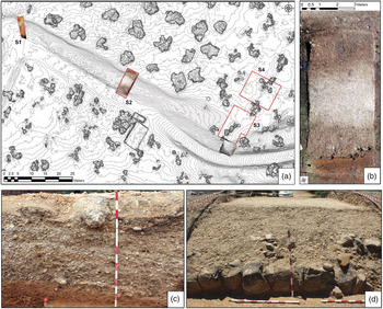
With this historiographic information, we designed a new research protocol to identify the Ianus Augustus in this territory. Creation of a high-precision digital surface model allowed the definition of a raised 75-m-long stretch, in which several archaeological test trenches were dug, revealing a road structure with a trapezoidal section. The remains of the road's margines (curbstones) were preserved at the northern end of the test trench (Figs. 2–3). Excavation revealed a complete section of the road that proved that it was an ex novo construction. A sequence composed of several massive horizontal gravel deposits served as a preparation for a series of transit surfaces made up of layers of plastic marls barely a few centimeters thick. The superposition of these transit surfaces and their respective preparatory layers denote repairs to the road, which would have been heavily traveled. The last level of worn road surface is preserved around 90 cm above the surrounding surface (agger). Finds included clavii caligae similar in form to those documented in the excavations on various stretches of the Via Augusta in the province of Ciudad Real and at La Font de la Figuera in Valencia.Footnote 47
Intervention on the Camino de los Romanos (Via Augusta). (a) Detailed topography with the situation of the test trenches and sections; (b) part of Test Trench 2 (S2) with the first wearing surface of the road; (c) road section (S1); (d) part of Test Trench 2 with the margines of the road. (Courtesy Iliturgi Project.)

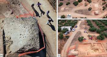
(a) Southern pillar of the Arch of Augustus, looking east; (b) pillars of the Arch of Augustus after excavation and their location in relation to the Roman road, looking north; (c) general view of the excavation, looking west. (Courtesy Iliturgi Project.)

As we mentioned above, there is considerable debate regarding the identification of the Via Augusta between Corduba and Castulo, with two possible itineraries suggested (the red line on Fig. 1B–C). Since our excavation of the road did not reveal any phase datable before the Early Empire, we believe that this road and the associated monumental complex of the arch, the ara terminalis, and the bridge reflect an ex novo creation. This building project, dated to the beginning of the 1st c. CE, corresponds to the construction of the Via Augusta with the itinerary recorded on the Vicarello Cups.Footnote 48 It established a new way of relating to the River Guadalquivir via the bridge, abandoning the fords, the traditional system of crossing the three rivers in the area that determined the southern route on the section between Corduba and Castulo, the Via Heraklea (the yellow line on Fig. 1B–C).
Nevertheless, there can be no doubt as to the survival of the Via Heraklea, given that Obulco and Urgavo continued to be important centers of cereal production during the Early Empire. This route, named Iter a Corduba–Castulone on the Antonine Itinerary, has been defended as the main branch of the Via Augusta,Footnote 49 rather than the Alio itinere to the north (where we located the Ianus Augustus), which is interpreted as a secondary branch (Fig. 1B). Here we consider the possibility that the two options reflect the dynamics of coexistence between an ancient traditional route that connected important political centers (Obulco, Urgavo) and the Bajo Guadalquivir region, and a new route (the Via Augusta) that would have enhanced the importance of other centers (Isturgi, Ucia, Epora). Establishment of the new route would have led to the appearance of several new mansiones (Ad Noulas, Ad Locus, Ad Decumum) along the route, and an infrastructure marked by a system of bridges over secondary rivers and streams.Footnote 50 Finally, passes to the north and south of the Guadalquivir would have diverted the area's mining resources toward the new road. This could perhaps explain the existence of places such as Sevilleja and Santa Potenciana that can be dated to the Augustan era.
The fact that this stretch ended up being considered an alio itinere (“alternative route”) is perhaps evidence of its decline. Loss of its initial preeminence could be related to the lifespan of the bridge over the Guadalquivir. This hypothesis could also explain the lack of mention of the Ianus Augustus on the Vicarello Cups, which can be dated no later than the 1st c. CE.Footnote 51 The question remains to be resolved, as the absence of any reference to the Ianus Augustus on the cups would not explain its lack of prominence as an administrative border, an importance that is attested in the limits of the conventus iuridici.Footnote 52 Finally, as Anne Kolb has accurately pointed out, the policy on roads was one of the most significant symptoms of the opening up, development, and consolidation of a conquered area.Footnote 53 In this territory in particular – in the area around Iliturgi – we observe how, after its conquest in 206 BCE during the Second Punic War,Footnote 54 a further two centuries were needed to consolidate the full implementation process of the incipient Roman Empire.
Ianus Augustus, the arch
During the course of the archaeological survey work carried out around the Camino de los Romanos, a large structure was found; it was partially visible at the point where the road begins to descend from the Espeluy plain to the River Guadalquivir (Fig. 3). Its visible part, a large opus caementicium pillar, is quadrangular in shape, 4.98 m (16.5 Roman feet) on each side and 1.2 m deep (4.05 Roman feet), on a base with a preparation of limestone fill. It is visible due to the construction in the late 19th c. of a road that altered the topography of the surrounding area and affected the foundations themselves, leaving them above the circulation surface of the new road. Its cubic shape and the fact that it is associated with a Roman road in the area in which most experts place the Ianus Augustus led us to propose a multidisciplinary archaeological strategy. Capture of the current surface by means of a UAV photogrammetric flight using a ZENMUSE X5 15-mm focal-length camera at an average height of 80 m resulted in a digital terrain model with a resolution of 7.5 cm and an orthophoto with an accuracy of 2 cm. An archaeological microsurvey combined with a geophysical survey using multichannel 3D ground-penetrating radar (600 MHz antenna) was also carried out. Finally, archaeological test trenches were dug with the aim of defining the documented structures and their associated stratigraphic sequence.
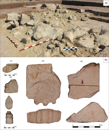
The first excavation attested to the existence of another pillar with an orientation and structural configuration identical to the one on the other side of the road, thus confirming the existence of an arch. An accumulation of local sandstone ashlar fragments in relation to the second opus caementicium pillar would have been part of the arch structure, although now largely destroyed (Figs. 4 and 8).
(a) Remains of rubble resulting from the destruction of the arch; (b) some significant elements: fragment with geometric decoration (144); fragment of architectural decoration (269); pilaster (238); crimped voussoir fragment (166). (Courtesy Iliturgi Project.)

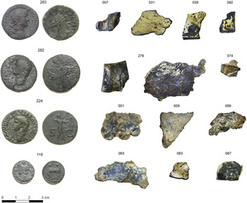
The dimensions of the second platform were identical to those of the first (4.98 m × 4.98 m × 1.2 m); in other words, both were foundations designed to support a large structure. The two opus caementicium pillars supported the arch, whose components were later systematically removed and reworked in situ for subsequent reuse. This generated a large amount of building debris, including, of particular note, fragments of listels, tori, and a large pilaster shaft fragment with four traces of fluting on one of its faces. Also preserved were the remains of ashlars that will be the subject of a detailed architectural study to deduce their full dimensions and modules. There was even a large fragment of a crimped voussoir, an architectural feature closely related to arches and with parallels on the bridges of Villa del Rio and Los Pedroches, both on the Alio Itinere Corduba–Castulone section of the Antonine Itinerary, of which this road is a part.Footnote 55 In addition, numerous fragments of lead and gilded bronze were found in the stratigraphic unit associated with the destruction of the arch (Fig. 5). No part of the building remained in its original position (except for the opus caementicium pillars) and both the stratigraphically contextualized finds and the chronology of the pottery and numismatic finds associated with the building material debris suggest that the complex was dismantled intentionally during Late Antiquity.
Roman coins in UE3B: Hadrian and Claudius (283/282/224) and a centenionalis of Constantine (119) (RIC VII, 547; 332–33 CE); remains of gilded bronze and possible litterae aureae (092). (Courtesy Iliturgi Project.)

The coin finds can be divided into three groups (Fig. 5). The first came from excavation levels near the surface and consists of coins from between the 1st and 2nd c. CE depicting Vespasian, Domitian, and Hadrian. A second group is associated with the abandonment levels of the monumental complex following its intentional destruction. These correspond to later series, such as a Julian the Apostate coin from the Fel Temp Reparatio series, dated between 355 and 361 CE,Footnote 56 and a Constantius II half centenionalis from the Gloria Exercitus series, dated between 337 and 347 CE.Footnote 57 These last two coins relate to the frequentation of the site after its destruction. Finally, a large group of coins found among the rubble results from the intentional destruction of the arch, the most recent of which is a Constantine centenionalis dated between 333 and 334 CE.Footnote 58 This last context can be correlated with a badly damaged coin of the Gloria Exercitus series (second quarter of the 4th c. CE) found in a building spoliation pit in the northern sector of the ara terminalis's platform (see below). In summary, the coins tell us that the site was frequented from the 1st c. CE and that the arch was probably demolished between the second and third quarters of the 4th c. CE, almost certainly during the reign of Constantius II, judging by the most recent coins found in the dismantling and amortization strata of the Ianus.Footnote 59
The placement and morphology of the two foundations, together with the preserved remains of elements that made up and decorated the elevation of the structure – the fragments of gilded bronze that attest the existence of a prestige sculptural group – and the position of the structure with respect to the road all suggest that it was a large arch, 14.80 m long and almost 5 m wide, with a single central opening through which the road ran, and probably more than 12 m high (see Fig. 8). Compared to other arches on the Iberian peninsula, such as those of Berà (12 m long; 2.4 m wide; 10.1 m high), Medinacelli (13.2 m long; 2.1 m wide; 8.1 m high) and Martorell (14.8 m long; 4.9 m wide; 10–12 m high),Footnote 60 the Ianus Augustus can be considered the largest Roman territorial arch in Hispania known to date, with very similar proportions to the aforementioned arch of Martorell.
It can be concluded, therefore, that these are the preserved remains of the Ianus Augustus located on the Via Augusta. The arch was (probably) dismantled intentionally in the 4th c. CE, which would explain the testimonial silence regarding it in subsequent periods.
The ara terminalis of the Ianus Augustus
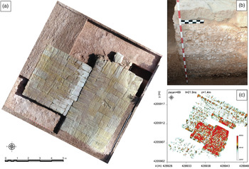
With the aim of detecting whether the arch consisted of various pillars or other adjoining structures, geophysical prospection was carried out in an area of some 1500 m2 around the two foundations. The results showed the presence of a large anomaly in the northern zone, parallel to the foundations and with an identical orientation (Fig. 6).
(a) Orthophoto of the building foundation adjoining the arch (possible ara terminalis); (b) opus caementicium foundation with 4th-c. CE spoliation pit; (c) ground-penetrating radar survey of the area prior to the excavation. (Courtesy Iliturgi Project.)

A new test trench documented a single monumental structure with two well-defined areas, one quadrangular and the other rectangular, barely 15 cm below the present-day surface level and 8.2 m (27.7 Roman feet) from and parallel to the arch foundation.Footnote 61 The size of both parts ranges from 4.84 m × 4.20 m (16.30 × 14.18 Roman feet) in the western part to 4.30 m × 7.25 m (14.5 × 24.5 Roman feet) in the eastern zone. The average size of the dry-laid ashlars was 1.3 m long by 0.5 m wide and 0.5 m high. Their orientation also varied, and they showed lines of opus isodomum. The distribution of the spaces is reminiscent of the structure of the Temple of the Divus Augustus in the provincial forum of Augusta Emerita, as a cella barlonga (transversal) building whose characteristics, given its preservation, are difficult to detail.Footnote 62
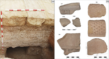
Below this platform are opus caementicium foundations with a depth of 1.45 m (4.89 Roman feet). Next to the northeast corner is a pit that appears to be filled with the remains of the building, which was also dismantled. It contains a large fragment of cornice that still preserves some remnants of its coffering, bands, and listels, with a badly damaged (intentionally?) plant motif decoration, as well as a very large fragment of the pulvino that would have crowned it (Fig. 7). This ancient spolia pit even penetrated below the opus caementicium foundations. We sampled the pit for radiocarbon dating, and the charred vegetal remains of Pistacia lentiscus gave a date of 1580 ± 30 BP (AJ659; Beta, 529716): 410–546 CE at 95.4% probability using the IntCal 13 calibration curve.Footnote 63 Together with the arch and the road, this building would have formed part of a single monumental complex laid out longitudinally with an identical northwest–southeast orientation. With respect to its function, we interpret it as an ara terminalis that could have been associated with the rights of passage linked to the Ianus itself, with a clear connection to the imperial cult.
Building adjoining the arch (possible ara terminalis). (a) Part of its foundation and spoliation pit; (b) architectural remains found in the pit (611, 579, and 350: cornice remains; 603: pulvino). (Courtesy Iliturgi Project.)

The presence of part of a large pulvino (Fig. 7), together with the disposition of the previously described platform, suggests a monumental structure. This is also implied by the size and technical quality of the platform's foundations, which were executed by filling a cube-shaped pit with mortar and rubble (opus caementicium) arranged in different elevations, above which the ashlar platform was built. The presence of monumental altars in Roman interprovincial frontier monuments is frequent and well known. In this respect, the structure unearthed in Mengíbar – as a boundary marker with an important ritual role – would have been related to similar monuments such as the Ara Trium Galliarum in Lugdunum or the frontier monuments indicated in the Tabula Peutingeriana, including the arae fines romanorum, the Altar of the Philaeni on the border between Tripolitania and Cyrenaica (Arephilenorum) and the Ara Alexandri.Footnote 64 Another comparandum would be the Arae Sestianae as indicators of the northwestern limit of the province of Tarraconensis.Footnote 65 The relationship of these altars with the beginnings of the imperial cult, particularly in Baetica and at the hands of the army, was illustrated by Francisco Marco, who pointed out that:
in any case, the example of the Ara Tarraconensis is the first of a series of initiatives … that the commanders-in-chief of the victorious armies of Rome would undertake in various western areas, ranging from the Arae Sestianae or Augustae to the great altar of Roma and Augustus ad confluentes Araris et Rhodani or the Ara Ubiorum on the banks of the Rhine, based on which the imperial cult of Lower Germania was consolidated.Footnote 66
It would not be strange therefore to find a site for worship of the emperor linked to the Ianus Augustus on the frontier of Baetica, a region under senatorial administration, as an indicator of the power of the emperor in that territory.
Although the scarcity of elements found means that it is premature to elucidate precisely the type of structure that would have been erected on the sandstone platform, the presence of the large pulvino could suggest a similarity between this ara and other monumental altars at important civic public complexes in Roman Hispania. Examples include the altar of Augustus in Tarraco and the monumental altars in Corduba and Emerita. In those cases, in the absence of archaeological evidence, iconographic depictions on coins allude to rectangular altars, sometimes adorned with pilasters and other elements such as bucrania and garlands, and normally completed with two rounded pulvinos on a cornice.Footnote 67 This type of altar is well documented archaeologically in Roman Hispania, particularly in cemetery areas, as well as in public and civic contexts.Footnote 68 In summary, the Ianus Augustus altar would have been built along the same lines as the many examples of imperial monumental altars that were widespread in the provinces during the Augustan period and throughout the 1st c. CE.
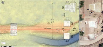
Thus, the archaeological excavation in this area has allowed documentation of the remains of the road surface, the foundations of an arch that straddled it, and a monumental structure, all of which were (possibly) intentionally dismantled in Late Antiquity. The location chosen for this monumental complex would have made it a visual reference in the landscape, as it would have been visible almost without interruption from a distance of 3 km when approaching from the west, and from almost 2 km from the east (Figs. 8–9 and 11).
Local relief model of the area near the Ianus Augustus monumental complex. Section in the road and the arch foundations and the possible ara terminalis. (Courtesy Iliturgi Project.)

Digital terrain model with viewshed from the arch. Points of observation 32 (offset altitude 10 m). (Courtesy Iliturgi Project.)

A bridge over the River Baetis?
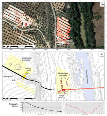
With the objective of archaeologically defining the area in the vicinity of this monumental complex, a geophysical survey was carried out using ground-penetrating radar.Footnote 69 The survey was divided into two areas based on the results of the prior archaeological microsurvey (Fig. 10). To the west of the monumental complex, an area of 0.5 ha was set out using the route of the road as the southern boundary. It contained a documented concentration of tile and building material, as well as pottery, including various sherds of late southern Hispanic terra sigillata dated between the 4th and 5th c. CE.Footnote 70 In this area the geophysical survey detected a possible north–south oriented building with a perimeter wall and a large number of collapses and extractions both inside and outside. The possible presence of floor levels or internal structures below these collapses cannot be ruled out. This location yielded the largest number of roof tiles on the surface. To the west of this new building is a possible pit filled with a mass of stones.
General scheme of the Ianus Augustus monumental complex. (a) Zones surveyed with ground-penetrating radar; (b) general scheme with an indication of the possible foundation of a bridge over the River Guadalquivir (Baetis flumen). (Courtesy Iliturgi Project.)

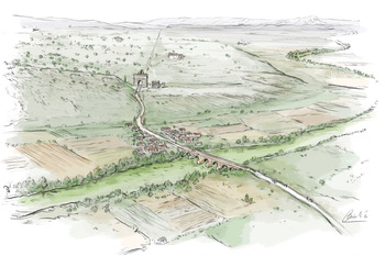
In the eastern zone, at a level some 20 m below the excavation area, adjacent to the River Guadalquivir, the archaeological microsurvey defined an area of nearly a hectare on the surface of which was a large number of tiles, slate, building materials, and fragmented ashlars, associated with common ware and Hispanic terra sigillata (1st–2nd c. CE).Footnote 71 Within this delimited area, only 4,950 m2 could be surveyed geophysically. The anomaly maps show a series of rectangular alignments interpreted as building walls (Fig. 10). Finally, an H-shaped structure was detected with a perimeter containment wall, a fill of concrete or a similar solid material, and a height of some 2.2 m. Its approximate dimensions (9 m × 6 m) and its morphology are similar to the end pillars of some types of Roman bridge.Footnote 72 Although an excavation is needed to confirm this hypothesis, the ground-penetrating radar data might represent the foundation remains of a bridge over the River Guadalquivir. The bridge would have carried the Via Augusta and would have been visible from the monumental complex consisting of the arch, the road, and the annexed building situated some 230 m to the west (Fig. 11).
Reconstruction drawing of the Ianus Augustus monumental complex, showing the bridge over the River Guadalquivir, administrative buildings facing the Via Augusta, and the prominent topographic location in the landscape of the arch and the ara terminalis. (Drawing by I. Diéguez.)

It should be recalled here that the references to the Ianus on the different milestones mention two elements, the arch and the river (a Baete et Iano Augusto) on the border between the provinces of Baetica and Tarraconensis. The river is the provincial boundary, and the arch marks the beginning of the Via Augusta. Thus, they constitute an exceptional and commemorative monumental landmark indicative of Augustus's political project.Footnote 73
Once again at the Ianus Augustus: prospects for future research
The present investigation has confirmed the existence of a monumental complex linked to the Via Augusta on the border between the provinces of Baetica and Tarraconensis. New excavations and a detailed architectural analysis will be necessary to fill in the sparse stratigraphic evidence at the site resulting from its intentional destruction and abandonment, attested at least in the late 4th c. CE, as well as the subsequent damage caused by plowing. A geophysical survey on the left bank of the Guadalquivir revealed elements indicating the possible existence of a bridge, as well as evidence of other buildings (Fig. 10). All this remains to be confirmed by future excavations.
The ongoing research raises many questions. What was the reason for the intentional destruction of the Ianus Augustus? Was it dismantled to repair the bridge over the Guadalquivir? Was it used as a quarry for other nearby buildings? Alternatively, could its dismantling reflect the redrawing of the provincial borders in Hispania and their redefinition during the time of Constantine or his successors?
The situation of the Ianus poses other questions. As indicated, there is a clear correspondence between various elements – including the arch, the altar, the road surface, and the provincial border – and the indications given on the milestones (a Baete et Iano Augusto), and, without doubt, its location shows that the border was the River Guadalquivir itself. In a recent study, España-Chamorro demonstrated that the milestones on the Via Augusta within the territory of Baetica used specific epigraphic formulations.Footnote 74 However, two questions emerge with regard to the milestone that determines the inclusion of the territory of the civitas located in Cerro Maquiz (Mengíbar) as part of Citerior-Tarraconensis.Footnote 75 First, the distance indicated “a Castulone” on the milestone (VIII milia passuum) places it to the north of the Guadalquivir, in Citerior-Tarraconensis, and not to the south, where we maintain that Cerro Maquiz corresponds to Iliturgi (and is therefore located in Baetica).Footnote 76 It is more than likely – judging from the distance indicated – that the milestone was placed where the Guadalimar flows into the Guadalquivir above the Via Augusta and near the ford in the river, thus reinforcing its aspect as a frontier marker.Footnote 77 Second, the milestone was found in the Cerro Maquiz area, although it had been reused as a stone sarcophagus in a tomb. In other words, its find context corresponds to a secondary use and it was possibly relocated to the south of the Guadalquivir.Footnote 78
Another important subject is the existence of two alternative routes for the Corduba–Castulone section that gives rise to the debate on the situation of the original Via Augusta. It is clear that the construction of the Ianus and the bridge over the River Baetis determined and restructured the road communications of the area, although this does not imply the abandonment of the pre-existing roads. It is to be hoped, moreover, that a future excavation in the area of the possible bridge will reveal more of its evolution and its relation to the road system linked to the Ianus. If the bridge was no longer in use, would this have necessitated the abandonment of the northern section and the more frequent use of the southern stretch of the Antonine Itinerary, using the ancient fords as crossings?
The research has also contributed new data for recognizing the ways in which the interprovincial frontiers of the Roman Empire were conceived, monumentalized, and transformed over time. In particular, we are able to visualize the new ideological hegemony that was legitimized through monuments of this type, which were oriented toward the sacralization of the emperor Augustus. Here, the Ianus Augustus is revealed not only as a territorial marker, but also as a symbol of Roman imperial ideology.
As previously indicated, detailed finds studies will be necessary (such as the gilded bronze of the possible statue group remains, or litterae aureae inscriptions and the remains of lead, as indicators of the existence of opus quadratum), as well as a meticulous architectural analysis of the complex and its modulation and proportions, based on the sparse remains documented. These will advance our knowledge of the formal configuration of the arch and the annexed building.
In terms of the latter, an interesting question is its formalization either as a cella barlonga-type (transversal) temple, similar to those of Mérida or the Temple of Concordia in Rome, or as an altar/ara terminalis (similar to the Ara Trium Galliarum in Lugdunum or the Altar of the Philaeni, Sestianae), with its structural reference to the Ara Pacis in Rome.Footnote 79 Coins also depict parallels, particularly the aforementioned examples of Corduba, Tarraco, and Emerita Augusta, as well as others all over the Empire.Footnote 80 On the other hand, the Iberian peninsula has other documented and historiographically discussed precedents, such as the Trophies of Pompey and the Tower of Urkulu.Footnote 81 These could be associated with the symbolic and territorial significance of the Ianus Augustus complex, although from our point of view their meaning is linked more to the commemoration of specific historical events, as is the case with the Trophies of Pompey, combined with and reinforced by their marked liminal nature.
The Ianus Augustus reflects the common denominator in the structure of the Roman political and symbolic landscape. As Stéphanie Guédon points out, Rome did not mark the limits of its Empire, which were providentially open to expansion. In contrast, a whole system was designed to indicate provincial limits, which were the responsibility of each territorial and political administration. The trophies located at limits or borders had a distinct honorary and symbolic nature as monuments commemorating specific military campaigns and victories.Footnote 82 As the same author explains, the numbers of this type of territorial marker increased particularly during the Principate of Augustus.Footnote 83 In addition to their political or symbolic roles, it is worth recalling their function as route markers that were perceptible in the landscape, a landscape that was not always completely controlled by or was unknown to its users. Personified through its markers, Rome domesticated its territory and assumed ideological control over it, as well as effective control of the transit of people and goods.
As Edwin Ramage has explained along these lines, the creation of road infrastructures was one of the most powerful elements in emperor Augustus's propaganda in Hispania, Africa, and Gallia.Footnote 84 In the case of Hispania, he was presented as the successful leader of military campaigns or as the pacifier of the territory. The Res Gestae recount how the doors of the Temple of Ianus in Rome were closed following the end of the Cantabrian Wars, a process culminating with the consecration of the Ara Pacis by the Senate in honor of Augustus. During Augustus's sojourn in Tarraco, the aforementioned altar was dedicated in his honor. It is also in this context that the restructuring of the municipal and provincial limits in Hispania (termini Augustales) took place, as well as the promotion of various colonies throughout the territory. Among these was Iliturgi, mentioned in different sources just as Iliturgi, or, in some cases, as Iliturgi Forum Iulium, which was very close to the location of the Ianus Augustus.Footnote 85 The Via Augusta is considered by Ramage to be one of the most powerful elements in the construction of the emperor's propaganda, and part of its design would have included the prominent landmark of the Ianus.Footnote 86
Although it is difficult to confirm the hypothesis based only on the archaeological evidence from the excavations of the Ianus Augustus, we fully agree with Ramage's proposal to link it with the discourse of the Pax Augusta and the Victoria Augusta.Footnote 87 In this respect, the Ianus Augustus identified in Mengíbar could be symbolically and iconographically associated with key elements of the new imperial ideology reflected in other arches. Examples of these include the Arch of Augustus at the heart of the Roman Forum, on which the iconography of the Victoria Augusta refers to the military victory of the princeps and the restoration of the state. In the case of Mengíbar, the Victoria Augusta meant the pacification and organization of the provincial territory under a new concept of state.
Territory, frontier, and Pax Augusta are key words to define and explain this monumental complex. C. R. Whittaker reminds us of Mary Douglas's interpretation regarding the complex ideological and cosmogonic narratives revolving around frontiers and liminal zones.Footnote 88 These places lend themselves to the celebration of rites of passage designed for the purification of transitions. Such places of transit define the end and the beginning of a journey, an itinerary, a controlled space, but also project the idea of domination beyond the frontier itself.Footnote 89 As Arnold van Gennep's magnificent essay reminds us, the portals, statues, bridges, and arches are determining factors for rites of passage, to which we have to add the significance of their delimitation of territory using the watercourses.Footnote 90 This line of study in the research on the Ianus Augustus should be combined with its architectural and modular analysis to identify new indicators for the configuration of the monumental complex.
Aside from its imperial and symbolic dimensions, this process also has a possible local reading. The new Augustan frontier above the Guadalquivir perhaps reflected the former limits of the territory of Castulo, once the capital of Oretania and at the time probably the most important town in the Upper Guadalquivir region. It has been argued that the modification of the Baetican frontier by Augustus was aimed at controlling the resources of the different mining districts in the present-day provinces of Almería, Granada, and Jaén.Footnote 91 However, the particular case of the inclusion of Castulo in the province of Tarraconensis may also correspond to an internal demand to sanction the existence of the territorial structure prior to the Roman conquest.Footnote 92
The area around Iliturgi, with its confluence of rivers (Guadalimar, Guadalbullón, and Guadalquivir), was also the site of the convergence of the limits of Turdetania, Oretania, and Bastetania. This is clearly demonstrated by the existence of both archaeological and linguistic frontiers.Footnote 93 Here the River Guadalbullón determined the limit of Turdetania (east–west), while the Guadalquivir defined the frontier of the territories of Castulo (Oretania). In the late 3rd c. BCE, the latter would have had a clear regional nature, encompassing the territories of some of the main towns in the Upper Guadalquivir region.Footnote 94
In conclusion, the case of the Ianus Augustus offers a unique opportunity to understand the articulation and configuration of an interprovincial border of the still-incipient Roman Empire. The Ianus Augustus combined elements of prestige with an outstanding symbolic significance, such as the arch and the ara terminalis, which joined the road and the bridge over the Guadalquivir to form a monumental complex transmitting the legitimation policy of the emperor Augustus and his perception of the symbolic appropriation of the landscape.
Acknowledgments
This study was carried out as part of the Excellence Project entitled “Methodology for the archaeological study of battlefields and sieges in the context of the Second Punic War: The Battle of the Metaurus and the sieges of Iliturgi and Castulo (207–206 BCE)” (HAR2016-77847-P), Ministry of Science, Innovation and Universities of Spain. The University of Granada provided a grant to M. G.-R. for postdoctoral study in the School of Archaeology and Ancient History of the University of Leicester (Programa de Perfeccionamiento de Doctores, Plan Propio del Vicerrectorado de Investigación).
The research team wishes to express its gratitude to Mengíbar Town Council (Jaén), the Friends of the Iberians Association and the Institute of Iberian Archaeology. Their collaboration and contributions made it possible to begin investigating the site. Our thanks also to the Provincial Government and the Territorial Department of Culture, particularly to Narciso Zafra, for his support and his contributions to the excavations. Likewise, we would also like to thank Alfonso Montejo for his work on drawing up the dossier for the declaration of the Arch of Augustus as an asset of cultural interest, Javier Vallés (Archaeometry Research Assistance Center, Complutense University), and Professor M. Schmidt for his generous scientific assessment. Finally, thanks to Iñaki Diéguez for his magnificent illustration.