

Nature, an invisible victim of armed conflict
The often-used phrase describing the environment as a “silent victim” of armed conflictFootnote 1 holds true to the extent that the level of destruction of and consequences for public health and ecosystems have gone largely unnoticed. Despite the visually impactful events of the Gulf War oil fires in 1991, limited attention was given to the widespread environmental destruction and the impact on lives, livelihoods, ecosystems and climate. The lack of visibility of conflict-linked environmental degradation also prevented the political debates and policy responses needed to prevent, minimize and mitigate environmental impact and strengthen accountability for military conduct. The bulk of the work conducted on the environmental dimensions of armed conflict until the early 2010s was largely driven by either the United Nations Environment Programme (UNEP) through its post-conflict environmental assessment,Footnote 2 or by legal scholars discussing the challenges for international law in relation to the environmental impacts of armed conflict.Footnote 3 Within the humanitarian disarmament community, civil society efforts have been successful in banning or regulating certain weapons and their impacts on health and well-being. The environmental consequences of armed conflicts, however, have received limited attention, with exceptions around the use of depleted uranium (DU) in munitionsFootnote 4 and initiatives around the health and environmental impacts of Agent Orange, used by the United States in Vietnam.Footnote 5
The main hindrance to attracting attention to the topic and building a solid campaign was the absence of a clear overview that demonstrated the severity of conflict-linked environmental damage throughout the cycle of conflict and laid out how this directly impacts people's health, livelihoods and futures. By contrast, past humanitarian disarmament campaigns, such as those banning landmines and cluster munitions or regulating the international arms trade, were able to build upon a wealth of visible impacts of weapons on people and their livelihoods that both helped raise international awareness of the humanitarian consequences while at the same time also functioning as an accountability instrument for the States using them. The causation between the weapon and its impact was fairly straightforward, which in turn benefited the international advocacy efforts.
Addressing the impacts of environmental damage on civilians, on the other hand, has proved more difficult, as demonstrating the relationship between exposure to toxic remnants of war, such as DU, and subsequent health impacts seems to be a Herculean task. This is due to the complexity around pre-existing environmental and health issues, mixed with the absence of relevant data to set up reliable scientific research that proves the causal link between illnesses and exposure to conflict-related pollution sources. Gaining access to military data on munitions use and the locations of such use, as well as on the targeting of specific objects that could result in the release of contaminants posing risks to civilians, has been a long-standing problem for humanitarian and civil society groups.Footnote 6 In the case of Iraq, for example, it took years of legal back-and-forth using freedom of information requests to the US and Dutch governments to get data on the coordinates of DU. This type of data is pivotal in the immediate aftermath of conflict to facilitate clean-up and remediation efforts, and would help to set up proper environmental health surveillance among possible exposed populations.
Having limited or no access to geographical data on conflict events, exposed populations, potential pollution sources, infrastructure damage and land use has posed serious challenges for campaigners and scholars alike in their work to improve understanding of the more complex direct and long-term impacts of conflict on the environment. As a result, the environment as a casualty of armed conflict has remained largely invisible among both States and global campaigners – at least until a decade ago, when increased worldwide access to the internet, combined with the rise of smartphone use, changed the global media landscape. This also brought conflict closer to home, putting the spotlight on developments where everyone could see what was happening directly on their smartphone. What promises did this technological turn of events bring for strengthening protection of the environment in armed conflicts, and for a stronger environment, peace and security agenda?
Armed conflict, data and the World Wide Web
A fundamental game-changer for researchers, journalists and civil society groups was the rapidly growing access to the internet and spread of smartphones that drastically changed the playing field. With access to the internet, people could post videos, photos and information on a myriad of online platforms, including a growing amount of popular social media platforms such as Twitter, Facebook and YouTube, or share them among groups of people using applications such as Telegram and discussion boards like Reddit. When protests in Syria escalated into armed conflict, the use of social media to share information with the world as the events unfolded proved essential to grasping what was happening on the ground. Syria has been referred to as the most documented armed conflict in history,Footnote 7 as citizen and civil society organizations have gathered and shared information from social media sources to document potential wrongdoingFootnote 8 conducted by the warring parties.Footnote 9
This gave rise to a new form of journalistic research: “open-source investigations” or “open-source intelligence”, better known as OSINT. This strand of work was originally linked with government intelligence agencies using information sourced from traditional, publicly accessible media, but now refers to researchers’ and journalists’ use of the wealth of open-source information to document conflict-related events. The work by the Bellingcat investigative journalism collective, in particular, helped leadFootnote 10 the innovation of this strand of research by documenting potential war crimes and grave human rights violations in areas affected by armed conflict.Footnote 11 These new tools brought with them a gigantic amount of data that could be used to identify possible locations of war crimes, track down responsible individuals or groups and in general document conflict-linked damages in near-real time. Many traditional news outlets soon started their own open-source teams, often producing groundbreaking investigative piecesFootnote 12 mixing both OSINT and on-the-ground investigations to shed light on alleged grave human rights violations or outright war crimes. The International Criminal Court (ICC) even admitted OSINT as evidence for an arrest warrant against a Libyan militant commander whose actions were captured on film, which could be geolocated and confirmed, paving the way for more prosecutions based on open-source materials.Footnote 13
These new approaches for using OSINT also found their way into the documentation of environmental crimesFootnote 14 and conflict-linked environmental degradation.Footnote 15 Existing risk assessment models for disasters, such as the Flash Environmental Assessment Tool,Footnote 16 were first used in combination with OSINT to identify areas at risk from conflict-related pollution in SyriaFootnote 17 and to document the scale of environmental destruction in IraqFootnote 18 and Ukraine,Footnote 19 both in 2017. This application soon became more common in assessments conducted by UN agenciesFootnote 20 and humanitarian responders, building a better environmental situational awareness of a wide variety of risks in conflict-affected areas.
Despite these advantages, OSINT also comes with serious challenges, mainly driven by mis- and disinformation efforts. State and non-State actors, as well as ideologically driven online communities, have at times created and spread fake imagery and claims from conflict areas in disinformation campaigns, as a means to fuel uncertainty and doubt among the general public.Footnote 21 This trend demonstrates the necessity of having an additional verification layer to using information from social media networks. Though many expect that artificial intelligence (AI) will contribute to increased spread of mis- and disinformation, so far technology is able to quickly disprove fakes.Footnote 22 The main challenge is how to ensure a rapid awareness-raising response to the disproven fakes in order to counter disinformation campaigns.
Space-based environmental monitoring
The development of OSINT went hand in hand with the dramatic increase in both the availability of satellite imagery and the computational resources required to derive insights therefrom. Open access satellite imagery is typically lower-resolution, including the European Space Agency's Sentinel-2 satellite (10m/pixel) and the US National Aeronautics and Space Administration (NASA) Landsat programme (30m/pixel). While these datasets are too coarse to identify individual objects, they can be used to monitor larger-scale phenomena such as oil spills, crop burning or deforestation.Footnote 23 High-resolution imagery from private companies such as Maxar, Airbus and Planet ranges from 30 to 50 centimetres per pixel. This type of imagery is rarely open access, but recently, high-resolution imagery has increasingly been available through Earth observation (EO) platforms such as Google Earth Pro which provide historic high-resolution imagery that can be instrumental for investigations. Many of these companies choose to release open data in response to natural disasters or similar events.
Even optical satellites with a very low spatial resolution can provide important information on conflict-induced environmental degradation. The Moderate Resolution Imaging Spectroradiometer (MODIS) has a spatial resolution of 1 kilometre per pixel, making it impossible to identify distinct features such as buildings or trees, yet what it lacks in spatial resolution it makes up for in spectral and temporal resolution – MODIS can image the entire planet every one to two days and can even automatically detect thermal anomalies from space.Footnote 24 NASA's Fire Information for Resource Management System provides daily data on active fires in near-real time, and has historic data going back to the year 2000. These detections can be used to track fires caused by fighting. Beyond estimating the scale and environmental toll of areas burned by fighting, such fire detections can also serve to verify the timing and locations of individual attacks, increasing public accountability. The Operational Linescan System, part of the US Defense Meteorological Satellite Program, is now also widely used to detect night-time lights, or the absence thereof; this could help determine to what extent access to energy has been cut off by damage to energy infrastructure.Footnote 25
Spectrometer instruments can also be used to track air pollution caused by conflict events. The Copernicus Atmosphere Monitoring Service (CAMS) combines data from a range of different sensors, including the Sentinel-5p satellite, to provide atmospheric data at a spatial resolution of 45 km on an hourly basis. One application of CAMS data, for example, showed a sulphur dioxide plume resulting from an attack on the Al-Mishraq Sulphur Plant in Iraq,Footnote 26 a plant used to produce sulphuric acid for use in fertilizers and pesticides. The attack destroyed the plant, causing a fire which burned for a month and released 21 kilotons of sulphur dioxide into the atmosphere per day – the largest human-made release of sulphur dioxide in history.Footnote 27 Beyond assessing the extent of a single event such as the Al-Mishraq fire, spectrometers measuring atmospheric gasses can also help to quantify routine exposure to hazardous levels of various pollutants such as nitrogen dioxide. Though air pollution can be measured using ground sensors, these are rare in conflict-affected areas.
While optical sensors and spectrometers rely on reflected sunlight in order to image, synthetic aperture radar (SAR) imagery is a type of remote sensing that uses radio waves to detect objects on the ground. These active sensors generate their own illumination and are able to produce imagery through cloud cover and even at night. SAR imagery has played an important role in environmental monitoring.Footnote 28 For example, because oil creates a slick surface and thus alters the way in which radio waves are reflected off of water, radar imagery has been used extensively to detect oil spills, including in conflict-affected areas.Footnote 29 More recently, SAR has also been applied to obtain rough estimates for urban damage assessments.Footnote 30
Application of remote sensing in armed conflicts
Remote sensing data has proven to be particularly helpful for tracking conflict-linked damage in numerous conflicts.Footnote 31 A wealth of academic research has illustrated the utility of remote sensing as an essential instrument that helps reveal the scale of land cover impacts linked with conflict, such as deforestation driven by fuel needs from the armed conflict in Syria,Footnote 32 forest cover changes associated with peace negotiations in Colombia,Footnote 33 and forest conservation in Rwanda.Footnote 34 Other research has focused on agriculture, demonstrating changes in agricultural land use in Syria,Footnote 35 increased yields from crops that may fund armed groups in Iraq,Footnote 36 and food insecurity caused by conflict-driven land abandonment in South Sudan.Footnote 37 There is also growing interest in using geographic information systems (GIS) to quantify air pollution from conflict-linked sourcesFootnote 38 and to map nature reserves and protected sites at risk from armed conflicts.Footnote 39 The ongoing Russia–Ukraine armed conflict has witnessed a surge in interest in GIS-based analysis that is yielding interesting results. A US-based consortium of universities and government agencies has set up the Conflict Observatory, providing a wide-ranging assessment of conflict impact, including on agricultureFootnote 40 and food security.Footnote 41 Both international and Ukrainian civil society groups have combined open-source data with EO to document the environmental dimensions of the conflict, focusing on energy infrastructure,Footnote 42 water infrastructure,Footnote 43 deforestationFootnote 44 or providing public databases with reported incidents with potential environmental consequences.Footnote 45
Over the last decade, civil society groups and humanitarian organizations have also addressed the use of explosive weapons in populated areas,Footnote 46 ultimately resulting in a broadly supported political declaration.Footnote 47 The intense damage caused by these weapons in urban areas poses additional risks to civilians from, among other things, environmental harm.Footnote 48 Remote sensing combined with OSINT is already being used for rapid damage assessments in Iraq,Footnote 49 GazaFootnote 50 and Ukraine,Footnote 51 which in turn are helping to identify hazardous sites in urban areas and quantify the debris and rubble, often mixed with hazardous materials.
Democratization of environmental research
Prior to the smartphone and EO data boom, most of the environmental assessment work carried out by UN agencies was done post-conflict, often years after the wars had ended, and was thus limited in types of locations and data on conflict impacts. In addition, this type of expert analysis was largely conducted by specialized agencies with trained experts. The revolution in environmental data collection analysis has meant that affected communities, campaigners and academics have direct access to specific information that can spur international campaigning to improve the protection of the environment. Several key multilateral processes and initiatives by international organizations to improve this protection were driven by the growing body of evidence that demonstrated the many layers of conflict-linked environmental degradation.
Since 2013, the International Law Commission (ILC) has been working to review existing legal avenues on the protection of the environment in relation to armed conflicts (PERAC), as legal principles need to be kept in line with modern developments and new insights. Over the course of nearly a decade, States met to discuss various draft principles put forward by the Special Rapporteurs leading this process. Though the process was unfortunately limited in nature in terms of civil society participation, NGOs and experts did have the opportunity to brief States in a number of public consultations on specific issues linked with conflict that helped underscore the importance of developing progressive international law. The final set of PERAC Principles was adopted by the ILC and was welcomed in late 2022 at the UN General Assembly in a resolution that “brings [the Principles] to the attention of States, international organizations and all who may be called upon to deal with the subject, and encourages their widest possible dissemination”.Footnote 52
On a practical level, the wealth of research further spurred attention on the topic. The dark visual imagery of the 2016–17 oil fires at Qayyarah in Iraq, blackening the skies for months, combined with ongoing research, proved to be instrumentalFootnote 53 for cementing support in getting a strong UN Environment Assembly (UNEA) resolution on conflict pollution in 2017, led by Iraq.Footnote 54 From a human rights perspective, a better understanding of civilians’ exposure from toxic remnants of war based on civil society input was further reflected in debates at the UN Human Rights Council, where UN Special Rapporteurs included concerns over children's exposure to hazardous war remnantsFootnote 55 and the broader need for information on communities affected by conflict pollution.Footnote 56
The linkages between environment and security gained further traction in the UN Security Council's work, where in particular better documentation of environmental harmFootnote 57 and links with detrimental public health impacts were reflected in the UN Secretary-General's report on the protection of civilians since 2019,Footnote 58 helped by further attention given during Arria-Formula meetingsFootnote 59 and specific country discussions on the environment–security nexus.Footnote 60
The picture that emerges from these technological developments and multilateral discussions outlines the importance of evidence-based advocacy. Furthermore, the innovative use of these developments can create meaningful change that builds momentum toward improving protection of the environment, people and the planet. Yet the future holds more potential, and the pace of technological change is rapidly increasing. With the rise of computer algorithms, how can researchers, humanitarians and campaigners make full use of this digital potential?
The future of conflict-linked environmental analysis
Current developments and future opportunities in analytical capabilities can be understood by exploring the application of modelling, machine learning (ML) and AI in environmental data analysis in conflict-affected areas. These include the proliferation of no-code remote sensing platforms, open-source software packages and free cloud computing services, all three of which significantly reduce barriers to public and professional monitoring and analysis of conflict-linked pollution, deforestation, water security, urban damage assessment and broader patterns of environmental harm that can be linked with military operations, along with the consequences for civilians, biodiversity and livelihoods.Footnote 61
Big data, machine learning and artificial intelligence
The increasing quantity and quality of satellite imagery has been met with a commensurate increase in computing power, enabling insights that were previously unfeasible. Moore's law –the observation that the performance of integrated circuits increases exponentially over time – is particularly relevant to the field of open-source remote sensing.Footnote 62 In the past ten years, many models of laptops have seen the number of central processing units increase more than sixfold. Graphics processing units, once a rarity, are becoming increasingly common in consumer electronics. The growth in computational power has considerably lowered the barrier to entry for the analysis of satellite imagery, previously limited to well-resourced organizations, and it is now possible to perform complex analyses on the average laptop. Beyond the planetary computers discussed below, there is also a growth of no-code platforms for visualization of satellite imagery.
Yet an even more significant development in the area of computing has been the growth in cloud computing platforms for the analysis of satellite imagery, particularly since 2016. These can be roughly divided into two categories: no-code platforms for the visualization of satellite imagery, and planetary computers capable of analysis at a global scale.
No-code platforms
Sentinel Hub is an online platform that allows users to access satellite imagery collected by the European Space Agency's satellites, NASA's Landsat and MODIS satellites, and other providers. Users can display imagery from different dates and perform basic image processing and analysis with a graphical user interface. Similarly, NASA's Worldview platform aggregates data from a wide variety of EO systems and allows them to be easily accessed with an intuitive interface.Footnote 63 These platforms have enabled anyone with an internet connection to load medium-resolution imagery of virtually anywhere on Earth in near-real time, without the need for technical skills or computing resources. Though advanced analysis is not possible on these platforms, simply visualizing multi-temporal satellite imagery enables monitoring of infrastructural damage, deforestation, pollution and a variety of other conflict-induced threats to the environment.
This can be explained by using the example of rare-earth mining in Myanmar, a toxic practice that is severely polluting the environment.Footnote 64 Sentinel Hub can be used to deliver insights on the proliferation of mines. Because these mines have precipitation pools filled with water, the location of such pools can be used to identify mines. Figure 1 visualizes a Normalized Difference Water Index (NDWI) calculation applied to a Sentinel-2 image, a simple process that highlights water in a scene and that can be applied with one click. Clicking on a point on the map visualizes the NDWI value at a given location over time.
NDWI applied to Sentinel-2 imagery over time. Source: Copernicus Sentinel Hub, authors’ calculation.

The graph in Figure 1 shows negative NDWI values for all of 2021, followed by a steep increase in August 2022, after which persistently high NDWI values are recorded. Sentinel Hub allows virtually anyone to verify the construction date of an unregulated mine in Myanmar, with just a few clicks.
Planetary computers
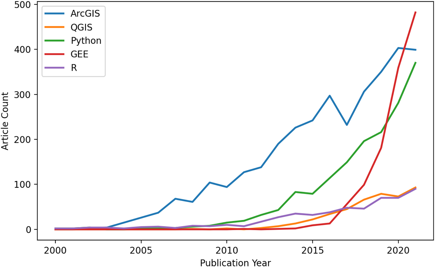
As geospatial datasets – particularly satellite imagery collections – increase in size, researchers are increasingly relying on cloud computing platforms such as Google Earth Engine (GEE) or the Microsoft Planetary Computer to analyze vast quantities of data. GEE is free for individuals and academic researchers and allows users to write open-source code that can be run by others in one click, thereby yielding fully reproducible results. These features have put GEE on the cutting edge of scientific research. Figure 2 visualizes the number of journal articles produced using different geospatial analysis software platforms.
Number of journal articles using different geospatial analysis software. Source: Web of Science, authors’ calculation.

Despite only being released in 2015, the number of geospatial journal articles produced using GEE (shown in red in Figure 2) has outpaced every other major geospatial analysis software, including ArcGIS, Python and R, in just five years. By storing and running computations on Google servers, GEE is far more accessible to those who do not have significant local storage or computational resources.
Optical satellite imagery can be combined with ML to deliver insights on conflict-induced pollution that would otherwise be unfeasible. Natural resource extraction often plays a role in conflict, as it offers a source of revenue for belligerents. Beyond fuelling armed conflict, such activity often has catastrophic consequences for the environment. Knowing the locations of these extraction sites is a prerequisite for their eventual clean-up, but active fighting can preclude the conduct of field surveys.
One example of conflict-related resource extraction involves the above-mentioned case of rare-earth mining in Myanmar, which takes place in mountainous areas of the country's northeast. The processes used to extract heavy rare earths are highly polluting, ravaging landscapes and poisoning waterways. Figure 3 shows the location of over 2,700 such mines, identified manually by Global Witness.
Satellite image showing locations of rare-earth mines in Myanmar. Source: Global Witness, with inset from Google Maps Basemap.

The inset satellite image in Figure 3 shows a close-up of one mine; bright blue “precipitation pools” – used to precipitate out minerals from a slurry of ammonium sulphate and mud – are a characteristic feature of such mines. Runoff from these pools leeches directly into the N'Mai Kha River, which runs the length of Myanmar and whose basin is home to two thirds of the country's population. By some estimates, the pollution caused by chemicals seeping into water bodies could take up to a century to clean up.
Using the labelled locations of pools as a training dataset, a convolutional neural network (CNN) can be used to automate the detection of pools beyond the study area, or in new imagery as it becomes available. Figure 4 shows the results of inference conducted by an object detection model using different source imagery to that which it was originally trained on.
Computer vision model trained to identify rare-earth mining pools. Source: Authors’ analysis of Mapbox Basemap imagery.

High-resolution optical satellite imagery and AI can thus be used to precisely identify the locations of highly polluting mines in an active war zone. This general approach is not confined to a particular geography and generalizes well to other contexts.
Machine learning and artificial intelligence
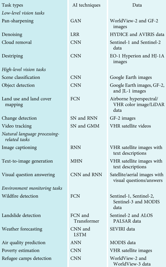
Within the humanitarian response community, there is growing interest in applications to improve analysis and response using ML. For example, ML is already being used to quickly identify informal settlements, conduct flood analysis and track flows of displaced persons.Footnote 65 Promising improvements use deep-learning (DL) models, often applied for land classification; examples of DL application in conflict areas will be outlined below. Researchers have tried various specialized DL models to identify oil spills and vegetation changes,Footnote 66 and the application of AI is gaining popularity in the field of remote sensing.Footnote 67 In conflict-affected areas, there have been attempts to apply AI to the detection of unexploded ordnance, using images taken by small drones; such initiatives can support swift remediation and land clearance efforts.Footnote 68
Review of tasks applying AI to satellite imagery

Acronyms used in “AI Techniques” column: artificial neural network (ANN); convolutional neural network (CNN); fully convolutional network (FCN); generative adversarial network (GAN); Gaussian mixture model (GMM); low-rank representation (LRR); long short-term memory network (LSTM); modern Hopfield network (MHN); recurrent neural network (RNN); Siamese network (SN).
Source: Yonghao Xu et al., “AI Security for Geoscience and Remote Sensing: Challenges and Future Trends”, IEEE GeoScience and Remote Sensing Magazine, Vol. 11, No. 2, 2023, available at: https://arxiv.org/pdf/2212.09360.pdf.
As discussed above, natural resource extraction often plays a role in conflict – despite its potentially catastrophic consequences for the environment – as it offers a source of revenue for belligerents. One example of this is the proliferation of makeshift refineries in northern Syria during the civil war. The destruction of Syria's oil infrastructure and the importance of oil as a source of revenue for armed groups has led to a rise in makeshift oil extraction and refining. These makeshift refineries are often constructed by digging a large pit, lining it with tarpaulin and filling it with polluted water. A furnace heats crude oil, which is run through a pipe cooled by the basin and collected in drums. These refineries also frequently leak, blackening large swaths of land around them.Footnote 69
Previous efforts to quantify informal oil production have involved manually sifting through satellite imagery and counting the makeshift refineries. This is a painstaking process that leaves a number of important questions unanswered. Even if one were to count all of the individual refineries, could we get an estimate of the polluted area? What if we wanted to count the refineries in a new part of Syria, or get annual or even monthly estimates of new refineries?
Using a combination of optical and radar imagery (Sentinel-1 and Sentinel-2) and a handful of known locations of such refineries, an AI model can be trained to identify areas contaminated by oil. The process of identifying refineries and oil spills can thus be automated across an area of thousands of square kilometres, and updated as new imagery becomes available.
Figure 5 shows the locations of model predictions for oil contamination. Photographs taken on the ground of several makeshift refineries are used to ground-truth model predictions. The model identifies areas with a high density of such facilities, giving precise estimates of their spatial distribution. Planetary computers are also often used to facilitate the dissemination of findings by allowing users to create and share interactive applications. For example, the present authors have created a dedicated linkFootnote 70 which directs to an application visualizing the results of the ML-based identification of makeshift refineries in northern Syria mentioned above. The application allows users to draw a rectangle on the map, which returns the total number of contaminated points in the area of interest as well as the number of contaminated square metres. Such tools could be used or adapted by practitioners to deliver actionable insights required for clean-up efforts.
Makeshift refineries identified in northern Syria. Source: Author's analysis of Sentinel-2 imagery.

Lastly, with intense fighting in and shelling of populated areas, rapid damage assessments are vital for first responders and analysts working on debris removal and management to get a clear understanding of the scale of destruction and health risks.Footnote 71 ML applied to Sentinel-1 SAR imagery can be used to get an estimate of damaged buildings. Users can select their own area of interest to generate the percentage of urban areas that have been affected by the war.Footnote 72 Though this is an area that is still in development, with numerous challenges, it has been identified as an area of future potential by researchers applying ML to damage assessment of cities affected by ongoing wars.Footnote 73
The examples given above provide an overview of the successful use of remote sensing tools in conflict-affected areas, but remote sensing also comes with significant limitations.Footnote 74 Firstly, in war zones with more cloud cover, such as tropical areas, or during wintertime, poor aerial visibility will constrain the timely availability of optical imagery. A second barrier is access to very high-resolution data; this type of data is still relatively expensive to acquire for researchers or organizations with small or no budgets. In addition, archive imagery from commercial providers frequently contains data previously ordered by their clients, which are often States or large corporations that have a certain location bias for security or commercial reasons. So, for example, there is abundant imagery on oil installations and certain urban areas in northern Libya, but hardly any imagery of rural areas in South Sudan, as there has been, to date, limited interest from commercial parties in acquiring these images.
Recent developments around air pollution detection pose similar challenges. Certain types of air pollution are not visible with the current resolution of public or satellite imagery; meanwhile, higher-resolution images are not easy to obtain as they are generated by specialized commercial satellites such as the latest one launched by the GHGSat project, dedicated to monitoring greenhouse gas emissions.Footnote 75 This sensor is capable of detecting small methane emissions but is only available for paying customers. Whereas with other optical data, one can still use different medium-resolution imagery or ground-based data to track a potential impact, identifying invisible air pollution remains a challenge.
Thirdly, misinterpretation of satellite imagery in the visual interpretation process is frequent, and this misinterpretation could under- or overestimate environmental impacts. Understanding landscapes or broader environmental occurrences is elementary for “reading” satellite imagery in order to understand what one is looking at. There have also been incidents in which researchers have used faulty classification of band-spectrum data to identify a certain type of value associated with an environmental occurrence that could lead to misinterpretation of events – for example, classifying seasonal phytoplankton algae in the sea as oil spills. Such false positives can be cause for misinformation and over- or under-calculation of environmental damages. They underscore the necessity of critical review, caution and inclusion of local expertise in reviewing data.
Fourthly, the use of remote sensing is mostly a tool for identifying and quantifying environmental risks and damages, through which better responses, and data to be used in norm-building and strengthening, can be developed. In applying these methods, researchers do not have to rely solely on remote sensing to determine causality between military activities and their environmental consequences. Verification of data through multiple sources, including OSINT and ground-truthing, is elementary for any attribution questions. This is particularly relevant for legal and policy avenues when it comes to attribution of severe damages to specific actors for which they can be held accountable.
Beyond the misinterpretation of satellite imagery by analysts, the growing use of automated and semi-automated tools poses challenges as well. Computer vision models are being used at scale to conduct everything from building damage assessmentFootnote 76 to detecting mass graves.Footnote 77 These models are trained by feeding an ML algorithm a large quantity of labelled data on the phenomenon of interest, but many computer vision models struggle with generalization and become more error-prone when the input data differs significantly from the training data.Footnote 78
Errors of both omission and commission can have significant implications in conflict settings. In the context of environmental monitoring, false negatives can have disastrous consequences if they allow risks to go unnoticed. False positives, on the other hand, can waste resources marshalled to address environmental disasters that haven't actually occurred, and reduce trust in a model. In all cases, automated and semi-automated tools for the classification of satellite imagery must be consumed critically and supplemented with external information to ensure that the weight of the conclusions is supported by the strength of the evidence.
However, due to the aforementioned general scarcity of data in conflict settings, access to ground-truth data necessary to validate the predictions of automated systems may not be available. Critical consumption of the outputs of these systems becomes even more important in this context, and there are several avenues through which this can be achieved. For all classification tasks, there are a number of accuracy statistics that are conventionally reported. “Accuracy” simply refers to the ratio of correct predictions to the total number of predictions, but this can be misleading in cases where one class is much more prevalent than another. “Precision” measures the proportion of positive predictions that are true positives, while “recall” measures the proportion of positive labels that were retrieved by the model. Depending on the scenario, a false negative might be more dangerous than a false positive (for example, in cancer diagnosis), or vice versa. As such, users of automated and semi-automated systems would do well to delve beyond simple measures of accuracy associated with the models that they use.
Beyond model-level accuracy statistics, many models also provide information on the confidence level associated with each individual prediction. For example, CNNs used in object detection generally provide not only a classification but also an associated confidence score. A CNN trained to detect oil spills will thus not only highlight areas that it predicts to be oil spills but will also typically provide a score ranging from 0 to 1 denoting its confidence in this prediction. For ease of use, many products built on using such systems only communicate the classification result. Once again, it would behove analysts using such systems to carefully assess not only the prediction, but the associated confidence score.
Finally, there are conflict events that can result in environmental health risks but will go undetected for a long time with remote sensing data or open-source information. This could also create a technology bias, as in areas with limited internet availability or no use of smartphones to record incidents, the absence of information could create a data vacuum. Though remote sensing could partially cover this gap, awareness is needed in order to avoid focusing solely on digital evidence and to keep investing in conducting field assessments. Ground-truthing is also needed to verify remote sensing assessment, and particularly with the rise of citizen-science methods, there are ample means and methods for quickly collecting data in the field.Footnote 79
Challenges and opportunities of innovative remote sensing for prevention of, response to and accountability for conflict-related environmental damage
This article set out to show how technology and digitization have shaped the trajectory of the environment–conflict nexus over the last decade. The application of open-source investigative techniques and satellite imagery has been an influential factor in the multilateral process to build and strengthen international norms around protection of the environment in relation to armed conflict. This is an important development that can further build accountability for environmental damages caused by States and non-State armed groups that have direct or long-term impacts on people and ecosystems. The ability to rapidly quantify the direct damage, such as the associated loss of livelihoods, the impact on food security or the exposure of civilians to a range of hazardous materials, has immense value. It has already been important for providing better guidance to militaries, as outlined in the updated Guidelines on Protection of the Natural Environment in Armed Conflict produced by the International Committee of the Red Cross (ICRC).Footnote 80
These advances in remote sensing and open-source environmental investigations for conflict-linked environmental damages are, however, not providing a holistic picture. What this article demonstrates is that through these frontier technologies, the scientific insights of conflict-linked environmental damages went from a “low-resolution” to a “high-resolution” image of a war zone – i.e., the data and imagery are providing a clearer understanding of the reality on the ground. Despite these improvements, however, we do not yet have a “very high-resolution” image of this type of damage, due to the absence of solid ground-truthing of the data, and there are still a number of constraints and limitations, as shown above. Still, there is already significant progress in delivering insights and contributing to scientific knowledge of the environmental dimensions of conflict-related damage, while also pushing the policy debate on improving the protection of the environment in relation to armed conflict a significant step forward through quantification and visualization.
Moving forward, how can accountability be strengthened for environmental damage linked with military activities? The wealth of conflict data on environmental degradation that can now be generated is already strengthening norms, as the identification and publication loop is significantly shortened, providing media and policy-makers with near-real-time access to major events. This is particularly visible in the Russia–Ukraine armed conflict, where military operations around nuclear power plants closely monitored by satellites have spurred UN Security Council debates over the risks of a regional environmental catastrophe. The visibility of damage to the environment during that conflict has also renewed debatesFootnote 81 over including “ecocide” as a crime in the Rome Statute of the ICC. Though neither party to the armed conflict is party to the ICC,Footnote 82 such a change would make it easier in the future to prosecute States and non-State actors for environmental damage. Exploring environmental accountability can build on historic examples around conflict-linked environmental damages, such as around the UN Compensation Commission's work on damages caused by Iraq's invasion of Kuwait,Footnote 83 and can be applied to cases such as the damage to the Nova Kakhova dam in Ukraine and its resulting environmental impacts.Footnote 84 The challenges ahead for such legal efforts relate to the proper registration of damages, having access to pre-conflict data, and developing a rudimentary environmental impact analysis that helps to quantify environmental damages, associated socio-economic costs, climate impacts and public health risks. Establishing causal relationships between military activities and widespread and long-term environmental damages can both have a norm-building effect and, in specific cases, feed into compensation mechanisms.
The attention on the environment in Ukraine has already resulted in millions of dollars of funding for the UN to establish coordination mechanisms to collect and analyze data and work on environmental clean-up, remediation and restoration efforts, and this approach should be applied to all conflict-affected countries.Footnote 85
Building accountability also depends on political forums or policies around environmental protection that have strong implementation mechanisms, political support and funding within their mandates. Various UNEA resolutions on conflict and environmental impacts will certainly benefit from dedicated and consistent implementation to ensure that they are fulfilling the intent with which they were created. At the same time, other international bodies addressing climate or environmental issues that are impacted by conflict lack any recognition of the conflict–environment nexus; this includes the UN Framework Convention on Climate Change, the Convention on Biodiversity, and the limited engagement on military activities and environmental impacts at the UN General Assembly, UN Human Rights Council and UN Security Council. Here lies an opportunity for the international community to work towards establishing a comprehensive approach to the environment, peace and security – one that bridges the policy gaps, connects discussions between these UN forums and international agreements, and at a bare minimum, establishes response mechanisms for conflict-linked environmental emergencies.
The opportunities that technology brings to this debate revolve around the relative ease of obtaining detailed auxiliary-level data on the environmental consequences of armed conflict, the health risks to civilians, the impact on natural resources that generate income for affected communities, and the broader damage to unique ecosystems and protected areas. With the help of ML, existing datasets on built-up areas, known industrial locations, critical infrastructure, protected areas and nature reserves, types of land cover and climate data can be linked with conflict events and used in automated environment assessment tools and predictive modelling of risks to civilians and ecosystems. Depending on needs, humanitarian organizations can make direct use of this information to improve coordination and response. Better quantification of environmental damage and estimations of financial losses can drive political and military strategic discussions that could have a preventive effect on battlefield decisions which would otherwise lead to serious environmental damage. Moreover, it could spur rapid clean-up and remediation efforts with the use of AI that is able to rapidly undertake spatio-temporal analysis of affected areas and provide data to authorities and relevant international organizations. The use of AI should require supervision by experts to verify and validate the results in order to prevent misidentification and ensure accountability for outcomes. These technological developments will increase the speed of analysis and response time to conflict events, bring more granular details to specific environmental consequences and contribute to more visibility of these dimensions of conflicts.
What remains a hanging thread is where the responsibility lies for undertaking such an imperative and groundbreaking effort. To ensure impartiality and independence, it would require the set-up of environmental architecture that brings together academia, civil society organizations and specialized UN agencies and that facilitates data collection, analysis, review of findings and dissemination of results. Through the sharing of data, dissemination of methods and training of local groups, the aim should be to have a decentralized approach where researchers and NGOs can work independently on applying these methodologies and avoid a monopoly of (Western) specialist agencies or groups doing the analysis. Such a broad endeavour, with local and academic expertise, can provide rapid response where needed, share insights in country-specific cases when discussed in multilateral bodies and inform relevant international debates on the environmental consequences of conflict (and potentially be linked with similar efforts on climate change). While the humanitarian and environmental community is at the threshold of a new era, the spread of AI in data collection, sharing and analysis will certainly push the debate into a new dimension where speed, visibility and accuracy will be game-changing in policy discussions and environmental response mechanisms. These developments and insights will highlight the need for improved protection of the environment, and the people depending on it, in times of armed conflict.