Introduction
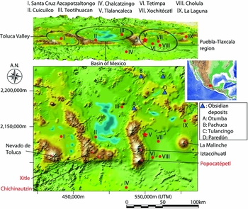
Central Mexico was one of the core areas for the development of complex societies in Mesoamerica (Sanders et al. Reference Sanders, Parsons and Santley1979; Blanton et al. Reference Blanton, Kowalewski, Feinman and Finsten1993; Spencer & Redmond Reference Spencer and Redmond2004). Archaeological research at major centres such as Teotihuacan, Xochicalco, Tula and Tenochtitlan has played a key role in our understanding of the genesis, transformation and decline of early cities and states (e.g. Sanders & Webster Reference Sanders and Webster1988; Mastache et al. Reference Mastache, Cobean, García Cook and Hirth2008). Despite this, the emergence of these urban centres remains poorly understood; archaeologists have only rarely explored their relationship to social transformations in other areas of Mesoamerica. This is largely due to the disproportionate research focus within Central Mexico. The Basin of Mexico has been perceived as the core area of Central Mexico throughout its history, and adjacent areas have only been opportunistically integrated into this ‘core’ when major findings required doing so, such as during the Formative period at Chalcatzingo, in Morelos (Grove Reference Grove, Adams and MacLeod2000). We argue that this centric view of the Basin of Mexico is, at least partially, the result of the amount of archaeological research conducted over the past century, and needs a substantial revision, especially for the Formative period (Lesure et al. Reference Lesure, Wake, Borejsza, Carballo, Carballo, Rodríguez López and De Ángeles Guzmán2013; Carballo 2015). In this paper, we present the preliminary results of fieldwork at the Formative site of Tlalancaleca, in Puebla (c. 800 BC–AD 200; Figure 1), and discuss its implications for early urbanism and socio-political dynamics in Central Mexico.
Map of Central Mexico showing the location of Formative sites: top) map viewed from an oblique angle; bottom) plan view. Roman numerals represent major Formative sites; blue triangles represent obsidian sources; red labels show volcanoes; black labels show major mountains (bottom map).

Although scholars disagree about what constitutes both a ‘city’ and ‘urbanism’, in this study we highlight some of the important elements recognised as urban by several scholars, including spatial extent, population size and density, social and functional diversity, urban-rural relationships, the degree of planning and the extent of the monumental core (e.g. Smith Reference Smith2003; Cowgill 2004; Storey Reference Storey2006; Algaze Reference Algaze2008; Marcus & Sabloff Reference Marcus and Sabloff2008; Arnauld et al. Reference Arnauld, Manzanilla and Smith2012). We contend that these elements need to be examined separately instead of assuming their mutual association a priori; this approach opens the possibility that some settlements may appear urban in some respects but not in others. Such a multidimensional approach allows us to conceptualise urbanism as a process and, more importantly, to avoid a categorical approach that imposes arbitrary thresholds between urban and non-urban settlements. A city can therefore be defined as a physical place where urban elements are variously expressed. Classic and Postclassic (c. AD 250–1521) urban traditions of Central Mexico, as exemplified by Teotihuacan and Tenochtitlan (Mastache et al. Reference Mastache, Cobean, García Cook and Hirth2008), were characterised by large aggregate populations and civic-ceremonial core areas with prominent buildings (Drennan Reference Drennan, Wilk and Ashmore1988). While these cities served as seats of ruling elites, how these traditions were created in specific historical and cultural settings remains poorly understood. This article presents an initial step towards remedying this lack of understanding.
Tlalancaleca and early urbanism in Central Mexico
Tlalancaleca is located at around 2500m asl on the north-eastern slope of the volcano Iztaccihuatl in the west-central part of the modern state of Puebla (Figure 1). Deep ravines, gullies, rivers and cliffs naturally protect the site. The civic-ceremonial core is located on a plateau, and a number of platforms are aligned along the east–west axis. Down the eastern edge of this plateau is a natural spring that provided a perennial water source for the ancient inhabitants (water no longer flows, probably due to the construction of an electronic pump for irrigation about 40 years ago). The whole site is now under cultivation for maize, beans and other crops, and is removed from the modern urban areas. Most Formative remains are probably well preserved (at least earlier ones), presenting an ideal situation for investigating the urban structures.
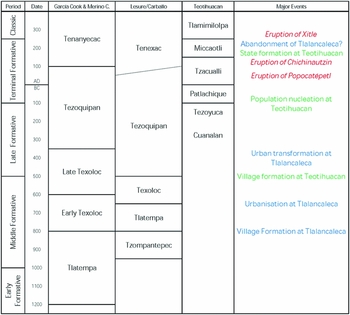
Over 40 years ago, Angel García Cook (Reference García Cook1973, 1981; see also Montaño Reference Montaño1998) conducted survey and test excavations at Tlalancaleca as part of a larger survey project in the Puebla-Tlaxcala region. García Cook dated the major occupation of the site between the Middle and Terminal Formative periods (c. 800 BC–AD 100) (Figure 2). According to the ceramic chronology that he created (García Cook & Merino Carrión Reference García Cook, Merino Carrión, Merino Carrión and García Cook2005), the first major occupation started during the Texoloc phase (c. 800–350 BC) or earlier and reached its apogee (covering 500ha) during the Tezoquipan phase (c. 350 BC–AD 100), after which the site was depopulated. Our research has confirmed these general trends, albeit with some modifications. Recent research by Richard Lesure, David Carballo and others in central Tlaxcala (Lesure Reference Lesure2014; Carballo 2015) proposed substantial modifications of absolute dates (650–500 BC for the Texoloc and 500 BC–AD 50/100 for the Tezoquipan), which are also followed here (Figure 2).
The chronology of the Puebla-Tlaxcala region and Teotihuacan (based on García Cook & Merino Carrión Reference García Cook, Merino Carrión, Merino Carrión and García Cook2005; Lesure Reference Lesure2014).

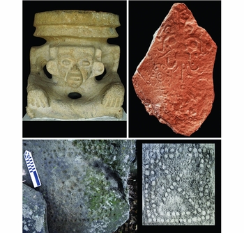
Despite its large and dense urban settlement with monumental architecture (García Cook 1981), Tlalancaleca has been overlooked in the discussion of early urbanism and state formation, most notoriously by archaeologists working outside of Central Mexico (e.g. Blanton et al. Reference Blanton, Kowalewski, Feinman and Finsten1993; Spencer & Redmond Reference Spencer and Redmond2004). Instead, Teotihuacan has been regarded as the first large urban centre to possess state-level political organisation in Central Mexico. As Cowgill (Reference Cowgill, Adams and MacLeod2000) emphasises, however, there were several urban centres prior to the rise of Teotihuacan, such as Cuicuilco (see Sanders et al. Reference Sanders, Parsons and Santley1979; Charlton & Nichols Reference Charlton, Nichols, Nichols and Charlton1997; Cowgill 2015). Socio-political dynamics at these centres provided cultural and historical settings, against which different social segments at Teotihuacan negotiated with one another to create cultural values, moral codes and sets of behaviours associated with urban life. In fact, Teotihuacan inherited architectural styles, spatial configurations, iconography and other types of material culture (Figure 3) from Tlalancaleca (García Cook & Trejo Reference García Cook and Trejo1977; García Cook 1981, 1984), Tetimpa (Plunket & Uruñuela Reference Plunket and Uruñuela1998, 2005, 2006, 2012; Uruñuela & Plunket Reference Uruñuela, Plunket, Gonlin and Lohse2007) and other sites in the Puebla-Tlaxcala region. It is possible that the inhabitants of Tlalancaleca had direct interaction with incipient ruling elites at Teotihuacan, including the movement of artisans, elites and other people. It is therefore critical to understand what urban life resembled at Formative centres if we are to understand the trajectories of urban and social transformations.
Cultural elements at Tlalancaleca: top left) stone brazier of the Old God of Fire (0.74 × 0.69m; photograph by Shigeru Kabata); top right) photogrammetric image of a petroglyph of the Storm God with a four- (or eight-)petal symbol (1.27 × 0.7m; created by Ariel Texis Muñoz); bottom left) photograph and (right) drawing of pecked glyphs or marcadores (with the glyphs at 0.48 × 0.45m; both by José J. Chavez V).

Our project at Tlalancaleca represents the first detailed study of large-scale urban centres during the Formative period in Central Mexico. Previous research in the Puebla-Tlaxcala region has focused on village sites (Plunket & Uruñuela Reference Plunket and Uruñuela1998) and medium-sized urban centres (Carballo Reference Carballo2009, 2015; Serra Puche & Lazcano Arce Reference Serra Puche and Lazcano Arce2011). While these studies greatly advanced our knowledge of social processes in Formative Central Mexico, it is fundamental that the relationship between the largest urban centres and smaller sites is addressed in order to understand fully the broader regional processes conducive to the development of social complexity towards the Classic period. Our project provides a suite of new data, which will enhance a more nuanced understanding of historically specific processes of social change, and thus stimulate discussion with scholars working in other areas of Mesoamerica so as to understand pan-regional processes of socio-political change better during the Formative period.
The Tlalancaleca Archaeological Project: 2012–2015 field seasons
We have completed four field seasons thus far, conducting topographic mapping, survey and surface collection, auger testing and test excavations. These have focused on collecting archaeological evidence of overall patterns in the developmental trajectory of the ancient city, specifically changes in the extent of the settlement, socio-spatial organisation (e.g. the presence of districts and neighbourhoods) and monumental construction (e.g. the distribution of platform structures and plazas).
Topographic mapping
We have produced a topographic map of the entire site and its adjacent areas based on aerial photogrammetry, GPS and a total station. With the support of Geodatum, a Mexican company (http://www.geodatum.com.mx/), we created a 3D map covering around 85km2. Photogrammetric data were first calibrated with GPS (Topcon GR-3) data taken at 22 terrestrial points within the mapped area, and were then converted into a digital elevation map. We also placed three datum points on the plateau for subsequent use in ground mapping with a total station. We have created higher-resolution digital maps with a total station for select areas, including the Cerro Grande Complex, one of the largest architectural complexes at the site.
Survey and surface collection
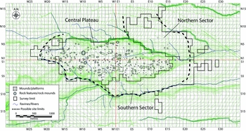
Using the digital map, we have conducted full-coverage ground survey and surface collection for an area of around 625ha. We set up a grid system consisting of 100 × 100m squares using an arbitrary point as the datum (UTM Zone 14N: E 548 500m and N 2 135 700m) and denominated each grid using a combination of cardinal directions (i.e. N, E, S, W) and consecutive numbers from the datum (e.g. N1E1) (Figure 4). We recorded all the visible features on the surface and placed them on the digital map. For surface collection, each grid was sub-divided into four semi-standardised units with each covering an area of approximately 50 × 50m (0.25ha). The shape of the surface collection tracts depended on the presence of pre-Hispanic and modern features, as well as surface visibility. We have so far completed a surface collection of approximately 1400 collection tracts. For each collection tract, we recorded visibility (five-scale score), types of vegetation or crops, density of materials (five scales from very dense to very dispersed), distribution patterns (homogeneous, localised or variable) and the type and degree of erosion. We collected all ceramic materials (except for body sherds smaller than 30 × 30mm), all chipped and ground stone materials, and other materials such as shell and bone objects in addition to including a sample of architectural remains (e.g. daub, stone slabs and lime plaster).
Site map showing recorded features and the grid system used for surface collection.

Manual bucket auger probe
While survey and surface collection were the only methods that covered the entire site, the visibility and quantity of surface features and artefacts is affected by numerous uncontrollable factors, such as natural and cultural disturbances. In order to complement the survey and surface collection, we implemented a method that examines the relationship between surface materials and subsurface strata based on auger probe (around 100mm in diameter). Manual bucket auger probing is an expedient method to examine stratigraphy and the depth of anthropogenic deposits, and is exponentially faster than test excavations.
Test excavations
We conducted a series of test excavations focusing on monumental structures in order to examine the exact dimensions, spatial configuration, construction process (including raw materials and techniques) and the timing of their construction. We selected two major locations: the Cerro Grande complex and structure C1 (Figure 4). The Cerro Grande complex is one of the major architectural complexes, which contains the largest pyramid at the site (Cerro Grande pyramid). Structure C1 is located about 900m south-east of the Cerro Grande complex; local people exposed parts of the eastern and northern façades over 40 years ago, and García Cook (Reference García Cook1973) reported the presence of a staircase with balustrades. Our excavations focused on the northern side of the structure and included the salvage excavation of a ceremonial cache at the western part of the plateau.
Developmental trajectories of Tlalancaleca
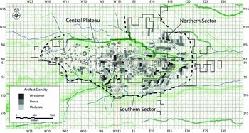
The overall results demonstrate a broad picture of urban transformations from the Middle to Terminal Formative periods (c. 800 BC–AD 200): the spatial extent, population size and scale of monumental construction clearly increased over time (although population densities are still unknown) with some reorganisation of neighbourhoods; some areas were, however, continuously occupied. In the following sections, we describe the major results for each phase and period. The site is divided for discussion into three major sectors: the central plateau, the northern sector and the southern sector (Figures 4 & 5). As artefact analysis is still in progress and a site-specific ceramic chronology remains to be established, our phase assignment is based on preliminary ceramic classification, building on the combined work of Montaño (Reference Montaño1998), Rattray (Reference Rattray2001), Serra Puche et al. (Reference Serra Puche, Lazcano Arce and de la Torre Mendoza2004), García Cook and Merino Carrión (Reference García Cook, Merino Carrión, Merino Carrión and García Cook2005) and Lesure (Reference Lesure2014).
Site map showing artefact density.

The Middle Formative period (c. 800–500 BC)
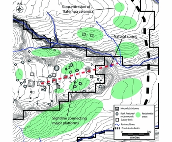
The preliminary results of the survey and surface collection suggest that Tlalancaleca was established as a major centre during the later Middle Formative period. During the Tlatempa phase (c. 800–650 BC), it was probably a series of dispersed villages; some concentrations of Tlatempa ceramics were identified in the eastern part of the central plateau and in the north-eastern portion of the northern sector (see Figure 6). It is not clear whether there were monumental structures.
Map showing the recorded features and the distribution of possible residential areas during the Middle Formative (c. 650–500 BC) at Tlalancaleca.

The Texoloc phase (c. 650–500 BC) demarcates the expansion of the settlement, with associated monumental construction. Texoloc ceramics are concentrated in the eastern portion of the central plateau, in the southern half of the northern sector, and in the northern and eastern portions of the southern sector, cumulatively covering a minimum of 80ha (Figures 5 & 6). There were probably several discrete neighbourhoods separated by ravines, gullies, small canyons and cliffs. These possible neighborhoods were identified based on a relatively high amount of domestic assemblages (e.g. domestic ceramics, daub fragments and metates and manos).
Civic-ceremonial structures were concentrated on the plateau, but some platforms were also present in the surrounding area, including those by the natural spring down the cliff at the eastern edge of the plateau (although these constructions remain undated). While there is no clear alignment of platforms on the plateau, a sightline that connects major platforms is oriented towards the spring. This may suggest the importance of the natural spring as a focal point of social interaction with religious connotations. The concept of ‘water mountains’ was developed in later Central Mexico and other areas of Mesoamerica (e.g. Sugiyama Reference Sugiyama2014), and it is possible that the physicality of the plateau as one such water mountain enhanced the special meanings attached to monumental structures on the plateau as well as to the plateau itself. It is not clear whether there were formal plazas, but areas between platforms on the plateau probably formed some open spaces.
The Late Formative period (c. 500–100 BC)
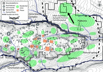
During the Tezoquipan phase (c. 500 BC–AD 100), the civic-ceremonial core and residential area extended towards the west, covering a total of around 500–550ha (Figure 7). It is probable that a central axis of the civic-ceremonial core (about 5.5° south of the east) was established during or after this transition. Due to uncertainties about the subdivision of this phase, we cannot determine whether this expansion was rapid or when monumental structures in the western plateau were first built. Based on artefacts recovered from test pits, we think the last monumental construction occurred during the Terminal Formative period (see below), but it is highly probable that several of the Terminal Formative structures contain earlier substructures that were built sometime during the Late Formative period (or earlier part of the Tezoquipan phase). One radiocarbon date (2267±30 BP: AA-105262) obtained through auger probe, and potentially from the first (or second) construction of the West Plaza compound at the Cerro Grande complex, suggests that it was built during either 400–350 cal BC (46.3%) or 305–209 cal BC (49.1%) at 95.4% (all the dates in this paper were modelled in OxCal v.4.2.4, using IntCal13 calibration curve (Bronk Ramsey Reference Bronk Ramsey2009; Reimer et al. Reference Reimer, Bard, Bayliss, Beck, Blackwell, Bronk Ramsey, Buck, Cheng, Edwards, Friedrich, Grootes, Guilderson, Haflidason, Hajdas, Hatté, Heaton, Hoffmann, Hogg, Hughen, Kaiser, Kromer, Manning, Niu, Reimer, Richards, Scott, Southon, Staff, Turney and van der Plicht2013)), which is consistent with surface collection data.
Map showing the recorded features and the distribution of possible residential areas and plazas during the Late–Terminal Formative (c. 500 BC–AD 200) at Tlalancaleca.

From the topography and a low amount of surface-collected materials, we have identified several possible plazas (Figure 7). Some of them are fairly large and could have accommodated the majority of urban residents. It is generally assumed that the size of open spaces has direct implications for the scale of social interaction and thus the nature of social identities and power relations negotiated during the events that occurred in those plazas (e.g. Tsukamoto & Inomata Reference Tsukamoto and Inomata2014). Although there is no direct association between the scale of plazas and the nature of political power, the presence of public plazas that could accommodate the majority of urban residents suggests polity-wide social interaction, whereas small plazas (especially those with restricted access) suggest limited social interaction within the urban community (Murakami Reference Murakami, Tsukamoto and Inomata2014). Based on this general framework, it is probable that there were multiple integrative mechanisms at varying scales of social interaction, such as neighbourhoods, local institutions (or their factions) and the city as a whole.
The presence of multiple large architectural complexes along with several, possibly public plazas deviates from other contemporaneous centres, such as Xochitecatl (Serra Puche & Lazcano Arce Reference Serra Puche and Lazcano Arce2011), La Laguna (Carballo Reference Carballo2009, 2015) and possibly Cuicuilco, where a single architectural complex stands prominent. The multi-centric spatial organisation of the civic-ceremonial core may suggest that there were multiple governing institutions with or without a single ruling class. Alternatively, civic-ceremonial institutions were functionally and/or religiously differentiated to complement each other, although it is equally possible that distinctive structures/complexes were built and used at different times. Further excavations are needed to test this theory.
Through this urban expansion, megalithic structures (high and low mounds of shaped boulders) were integrated in architectural complexes (Figure 7). There are no antecedents of such structures in Mesoamerica and their function is not clear. We removed the vegetation from the two megalithic structures in the Cerro Grande complex and identified multiple circular spaces. It is possible that they formed towers. Moreover, we identified numerous freestanding rock mounds and features throughout the site (Figure 4), many of which are made of shaped boulders. Test excavations on the megalithic structure attached to the Cerro Grande pyramid are planned to continue until an occupational level is reached for examining the structure's function.
Middle Formative residential areas in the northern and southern sectors were probably continuously occupied. There are several possible neighbourhoods on the plateau, which were newly established and separated by natural geography and civic-ceremonial structures. A ceremonial cache excavated at the periphery of a possible residential neighbourhood (Figure 7) was dated to 2168±30 BP (AA-105263: 360–271 cal BC (47.2%), 264–154 cal BC (45%), or 136–115 cal BC (3.1%) at 95.4%). The deposited ceramics probably belong to an earlier part of the Tezoquipan phase, and for this reason, we prefer the earlier date (i.e. 360–271 cal BC) for the cache. If so, the newly settled neighbourhood was probably established by at least the fourth century BC, which is consistent with our interpretation of urban expansion.
The Terminal Formative period (c. 100 BC–AD 200)
Through surface collection, we have identified a quantity of Terminal Formative ceramics, including flat-based outcurving bowls with or without nubbin supports (some have incised designs), wedge-shaped everted-rim ollas, and Thin Orange hemispherical bowls with a ring base, among others, many of which are commonly observed in Terminal Formative deposits at Teotihuacan (i.e. the Patlachique, Tzacualli and Miccaotli phases; c. 100 BC–AD 200/250). The presence of ceramics similar to those of the Miccaotli phase raises a possibility that Tlalancaleca was not totally abandoned around AD 100, as suggested by García Cook (1981), but instead survived longer.
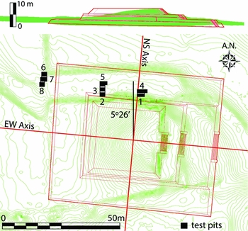
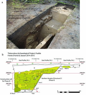
Our observation of surface materials is corroborated by the results of test excavations. Excavations at structure C1 (Figure 8) revealed the last episode of rebuilding, which consisted of the addition of a platform of an unknown height to the northern side (and probably covering all sides). At the foot of the northern façade of the previous structure (Figure 9), we identified the remnants of some burning event, probably a ritual associated with the beginning of the new construction (or the termination of the previous building). Two samples from the same context were dated to 1802±37 BP (AA-105266: 127–333 cal AD at 95.4%) and 1924±43 BP (AA-105265: 22–11 cal BC (1.7%), 2 cal BC–172 cal AD (95.6%), and 193–210 cal AD (2.6%) at 95.4%), which indicates that the ritual took place around AD 150 (combined date: 126–214 cal AD at 68.2% and 84–230 cal AD at 95.4%). Although we cannot determine how long it took to complete the last construction or for how much longer it was used, it was probably not abandoned for at least several decades or more, making it consistent with the Miccaotli date (c. AD 150–200/250).
Plan of structure C1 showing the location of test excavations and the reconstructed form of the platform.

Excavations at structure C1: a) the northern façade and excavated construction cells of adobe bricks abutted to the façade (photograph by Shigeru Kabata); b) profile drawing of pits 2, 3 and 5 (Roman numerals refer to layer numbers; ‘talud’ refers to a sloping façade or wall in Mesoamerica).

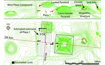
Although we do not yet have radiocarbon dates from the last construction of the Cerro Grande complex, it is probable that the last rebuilding took place late in the Terminal Formative period, perhaps contemporaneous with the last construction of structure C1. A high proportion of Terminal Formative pottery (70 per cent of all rim sherds) was surface-collected from the looted pyramid (Figure 10), and are probably from the fill of the pyramid. This indicates that the final construction took place sometime after the beginning of this period. An equally high proportion of Terminal Formative sherds were also collected from the Cerro Grande pyramid. From the top of this pyramid, a large stone brazier of the Old God of Fire was discovered by local people over 40 years ago, which suggests that the Cerro Grande pyramid was conceived as a fire shrine.
Plan map of the Cerro Grande Complex showing the location of test excavations.

Terminal Formative sherds are scattered throughout the site, but substantial changes were noted in the northern and southern sectors. Major concentrations of Middle–Late Formative occupations in the southern sector were substantially reduced, and this suggests that a number of residences were abandoned during the Terminal Formative period. In contrast, residential areas in the northern sector expanded northwards. Along with this expansion, two platforms were constructed (Figure 7). Auger probes recovered Terminal Formative sherds from the platform fills that were probably built during this period. The substantial shift of residential areas may reflect changes in geopolitical relations between Tlalancaleca and other settlements, and especially Teotihuacan. As a deep canyon delimits the northern edge of the central plateau, the northern sector was the only corridor leading from the north to the civic-ceremonial core. Increased human traffic along this corridor may have resulted in the expansion of settlements to the north.
Conclusion and future direction
Preliminary results of the Tlalancaleca Archaeological Project over the past four seasons have revealed patterns indicative of urbanisation processes. Probably starting from a series of dispersed residential groups, the eastern part of the central plateau was transformed into an arena for major civic-ceremonial activities some time during the Texoloc phase (c. 650–500 BC). The sightline connecting monumental structures, and the placement of residential areas, both suggest the centrality of the natural spring down the cliff as a focal point for social interaction and the creation of religious meanings associated with the plateau. The increasing extent of the settlement suggests that population size increased over time as the city expanded, leading to a major urban transformation during the Tezoquipan phase (c. 500 BC–AD 100), probably around the fourth century BC. Although the pace of this transformation is not yet clear, the possible establishment of the central axis of monumental structures suggests that it was a well-planned and immediate event, rather than a gradually incremented progression of Middle Formative settlements. We plan to examine the nature of this transition further through excavations at both monumental structures and residential areas.
The Terminal Formative period (c. 100 BC–AD 200) probably represents the apex of Tlalancaleca, as seen in the enlargement of monumental structures. A substantial settlement shift in the northern and southern sectors suggests a changing position of Tlalancaleca in the larger network of socio-political and economic relations in Central Mexico. It remains unclear whether settlement expansion to the north represents the movement of urban residents or whether it was due to immigration. The eruption of Popocatepetl in the first century AD certainly affected the Puebla-Tlaxcala region in various ways, and the continued research of our project will be important for better understanding macro-regional social transformations during the Terminal Formative period following this event (Plunket & Uruñuela 2005, 2006, 2012).
The spatial configuration of monumental structures at Tlalancaleca is vastly dissimilar to that of Teotihuacan: there is no central avenue or symmetric arrangement of architectural complexes; nor are there three-temple complexes and pyramids directly oriented to major mountains. A multi-centric spatial organisation was, however, common for both cities, and was probably not shared by other major centres. This may indicate that there was a measure of organisational or ideational continuity from Tlalancaleca to Teotihuacan. This possible continuity can also be gleaned from some commonalities in architectural style (talud-tablero) and techniques (the use of construction cells and lime plaster) (Murakami in press). Furthermore, the central plateau as a physical manifestation of a water mountain, and the Cerro Grande pyramid as a fire shrine, certainly constituted important cultural values associated with urban life at Tlalancaleca. These cultural values may have been integrated into the construction of the central precinct at Teotihuacan (i.e. the Moon Pyramid as a water mountain (Sugiyama Reference Sugiyama2014) and the Sun Pyramid as a fire shrine (Fash et al. Reference Fash, Tokovinine, Fash, Fash and Lopez Lujan2009)). Although it is currently difficult to examine further the cultural and socio-political relationships between Tlalancaleca and Teotihuacan, we argue that Tlalancaleca, along with other Formative sites (Uruñuela & Plunket Reference Uruñuela, Plunket, Gonlin and Lohse2007; Carballo 2015), provided structural parameters that both enabled and constrained practices of urban residents at Teotihuacan, which were eventually transformed, resulting in the creation of a new urban configuration.
Macro-regional urban transformations in Formative Central Mexico parallel those in other areas of Mesoamerica, in that several independent urban centres gave way to a single primary centre (e.g. Monte Albán in the Oaxaca Valley). While numerous different factors have been suggested for the successful integration of a larger population at those primary centres, including environmental, political, economic, technological and religious factors (e.g. Blanton et al. Reference Blanton, Kowalewski, Feinman and Finsten1993; Algaze Reference Algaze2008; Carballo 2015), the baseline remains that newly created cities were born out of previously existing socio-political networks. Diachronic comparisons of the different elements of urbanism mentioned in the introduction are therefore essential for understanding the process of genesis, transformation and decline of urban centres. Our future research will add more information on the ‘dawn’ of the Teotihuacan state, which will enable more nuanced comparisons with other areas.
Acknowledgements
We are grateful for the generous support of the local community at San Matías Tlalancaleca, especially Oscar Anguiano, Don. Higinio Varillas and Hilario Juarez. We also thank our field crews, and especially Hironori Fukuhara, Willem VanEssendelft, Natalia Mauricio, Mark Dennison, Paige Phillips and students at the Universidad de las Américas Puebla. Finally we thank the Instituto Nacional de Antropología e Historia (INAH) in Mexico and the Regional INAH Center in Puebla for permission to conduct research at Tlalancaleca. The Tlalancaleca Archaeological Project is funded by the Wenner-Gren Foundation for Anthropological Research (Grant 8852), the National Science Foundation (BCS-1524214), the Matsushita International Foundation, grants from Tulane University's Stone Center for Latin American Studies, the Committee on Research Grants, and the Lurcy Grant, awarded to Murakami, as well as the Grant-in-Aid for Young Scientists (A-24682005) and the Grant-in-Aid for Scientific Research on Innovative Areas (26101003) from the Japan Society for the Promotion of Science, awarded to Kabata. We are grateful for comments and suggestions by Ryan Hechler and two reviewers on an earlier draft of this paper.