

Introduction
The El Niño phenomenon occurs as a consequence of episodic warming of ocean surface temperature on the Pacific coast of western South America (Enfield Reference Enfield1989). Strong El Niño events cause the normally arid Peruvian coast to be inundated with high precipitation that can result in catastrophic floods, as well as alterations to local marine species habitat (Quinn et al. Reference Quinn, Neal and Antunez de Mayolo1987). The social and economic impacts of El Niño can be devastating, and for several decades archaeologists working in coastal Peru have discussed the correlation of El Niño with culture change, particularly ‘collapse’ (e.g. Moseley Reference Moseley1987; Sandweiss et al. Reference Sandweiss, Maasch, Burger, Richardson, Rollins and Clement2001, Reference Sandweiss, Maasch, Andrus, Reitz, Richardson, Riedinger-Whitmore, Rollins, Anderson, Maasch and Sandweiss2007; van Buren Reference van Buren2001; Dillehay & Kolata Reference Dillehay and Kolata2004; Sandweiss & Quilter Reference Sandweiss, Quilter, Sandweiss and Quilter2008). The connections between abrupt climate shifts and assumed cultural transformations are, however, complicated by a number of factors (Coombes & Barber Reference Coombes and Barber2005), including the difficulty of precisely correlating proxies for environmental alterations with the archaeological record (Calaway Reference Calaway2005; Sandweiss & Quilter Reference Sandweiss, Quilter, Sandweiss and Quilter2008). Consequently, problems of accurate correlation make it challenging for archaeologists to interpret human responses to abrupt environmental change.
Palaeoclimate proxy data from Peru demonstrate that the frequency of the El Niño phenomenon varied over time. During the first half of the Holocene, it was either absent or very low in terms of frequency. Between c. 5800 and 3000 BP, El Niño occurred, but less frequently than today, perhaps less than once in a generation. Finally, after 3000 BP, El Niño occurs more or less at modern periodicity (Sandweiss et al. Reference Sandweiss, Maasch, Burger, Richardson, Rollins and Clement2001, Reference Sandweiss, Maasch, Andrus, Reitz, Richardson, Riedinger-Whitmore, Rollins, Anderson, Maasch and Sandweiss2007; see also Rein Reference Rein2007; Carré et al. Reference Carré, Sachs, Purca, Schauer, Braconnot, Angeles Falcón, Julien and Lavallée2014). Importantly, it is during these latter two time periods that the central and north coast of Peru witnesses the development of early traditions of monumental architecture. Monument building especially flourished during the first half of the second millennium BC and continued until approximately 800 BC (Burger 1992), a time period known as the Initial Period (c. 1700–800 BC). Initial Period monuments are characterised by large, terraced platform and plaza complexes that functioned as temples. On the Peruvian coast, most temple complexes are located in inland river valley settings, reflecting a subsistence economy based largely on irrigation agriculture (e.g. Billman Reference Billman2002; Burger & Salazar 2012). El Niño-induced debris flows and flooding would have posed significant hazards to irrigation canals and agricultural fields (see below).
The proliferation of monument construction during a time of environmental dynamism raises the question of how people actively adjusted to these changes. It is therefore critical to have direct associations between the environmental event and the archaeological record in order to address these questions adequately.
In addition, the issue of direct correlation is critical because the intensity of El Niño rainfall and flooding can vary significantly between coastal valleys (Waylen & Caviedes Reference Waylen and Caviedes1986). This article presents geoarchaeological evidence in the form of sediment proxies for multiple second-millennium BC El Niño events at Huaca Cortada, a large Initial Period monument that forms part of the Caballo Muerto Complex in the Moche Valley. The proxies are unique because they are associated with specific construction phases, and in one case are dated by AMS. Although not all proxies were dated in absolute terms, the data presented here contribute high-resolution records of flooding at Huaca Cortada, which confirm and add detail to the findings of other scholars regarding El Niño in the second millennium BC (Sandweiss et al. Reference Sandweiss, Maasch, Burger, Richardson, Rollins and Clement2001, Reference Sandweiss, Maasch, Andrus, Reitz, Richardson, Riedinger-Whitmore, Rollins, Anderson, Maasch and Sandweiss2007). Furthermore, the close connection between temple building and abrupt changes in climate permit a discussion about the nature of human response to unforeseen meteorological phenomena.
The environmental setting of the Caballo Muerto Complex
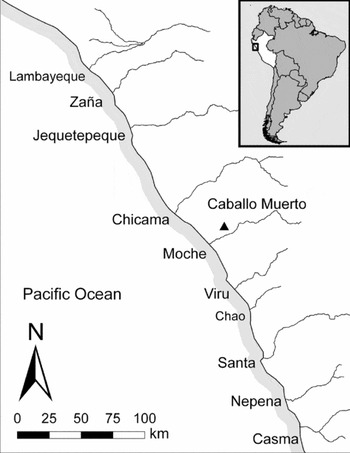
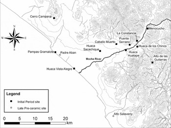
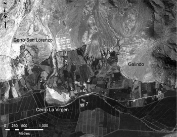
The Caballo Muerto Complex is situated in the lower Moche Valley at an altitude of 150m asl, and approximately 16km from the Pacific shoreline (Figures 1 & 2). Caballo Muerto is one of the largest Initial Period sites on the north coast of Peru, and consists of at least eight terraced platforms, dating from the early second tothe mid first millennium BC (T. Pozorski Reference Pozorski1983; Nesbitt et al. Reference Nesbitt, Gutiérrez and Vásquez2010; Nesbitt Reference Nesbitt2012a). This complex of mounds is widely distributed over a core area of 150ha that is bounded to the west by two large hills, Cerro la Virgen and Cerro San Lorenzo (Figure 3).
The location of the Caballo Muerto Complex and its position on the north coast of Peru.

The Moche Valley showing the Caballo Muerto Complex and other Initial Period settlements.

Satellite image of the Caballo Muerto Complex: 1) Huaca San Carlos; 2) Huaca de los Reyes; 3) Huaca de la Cruz; 4) Huaca Guavalito; 5) Huaca Cortada; 6) Huaca Curaca; 7) Huaca Herederos Grande and Huaca Herederos Chica. Image courtesy of the GeoEye Foundation.

The landscape that surrounds Caballo Muerto affords both agrarian opportunities and environmental hazards. Several of the largest Initial Period mounds at Caballo Muerto are situated near Vichansao, one of the major irrigation canal intakes in the lower valley, signifying that irrigation agriculture formed an important component of the subsistence economy (Moseley & Deeds Reference Moseley, Deeds, Moseley and Day1982; Farrington Reference Farrington and Farrington1985; Billman Reference Billman2002). Analysis of organic remains from Initial Period ceremonial and domestic contexts at Caballo Muerto identified macrobotanical and microbotanical remains of manioc (Manihot esculenta), peanut (Arachis hypogaea) and commonbean (Phaseolus vulgaris), as well as small quantities of maize (Zea mays), supporting the notion of a largely agrarian economy (Pozorski & Pozorski Reference Pozorski and Pozorski1979; Vásquez & Rosales Tham Reference Vásquez and Rosales Tham2009a). Faunal remains at the site specify a reliance on coastal resources including fish and molluscs, as well as inland game such as deer (Pozorski & Pozorski Reference Pozorski and Pozorski1979; S. Pozorski Reference Pozorski1983; Vásquez & Rosales Tham Reference Vásquez and Rosales Tham2009b).
Caballo Muerto is situated within an environment susceptible to El Niño flooding. Towards the north and west of the site are a series of dry stream channels (or quebradas) that were the source of significant debris flows during El Niño years. As with other areas of the Moche Valley, these channels are almost certainly late Holocene in age, and their formation reflects increased alluviation linked to El Niño (Huckleberry & Billman Reference Huckleberry and Billman2003). At Caballo Muerto, flooding of the Rio Seco quebrada was responsible for significant destruction of structures to the west side of the Huaca de los Reyes mound (Conklin Reference Conklin and Donnan1985: 143). There are signs that these debris flows reached the valley bottom where smaller-scale settlements were located. Excavations just to the south of Huaca Cortada revealed a thick layer of coarse river gravels overlying an early Initial Period domestic occupation surface. It is probable that this deposit was formed through the flooding of a relict channel sometime in the early half of the Initial Period (Nesbitt Reference Nesbitt2012b). There are no Initial Period occupational remains on top of the deposit and, therefore, it appears that flooding caused the relocation of low-lying settlements to other areas of the floodplain around Huaca Cortada.
Like other Initial Period settlements on the Peruvian coast (Burger 2003), Caballo Muerto was situated in a landscape that was vulnerable to catastrophic inundation brought on by El Niño. Flooding and resultant debris flows would have damaged or destroyed irrigation canals—potentially disrupting the subsistence economy—as well as settlements in the floodplain (Nials et al. Reference Nials, Deeds, Moseley, Pozorski, Pozorski and Feldman1979). In the following sections, the effects that El Niño had on the temple architecture of Caballo Muerto will be examined.
The Huaca Cortada mound
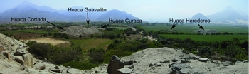
Huaca Cortada is situated today in the midst of agricultural fields at the base of Cerro la Virgen. The mound is one of the earliest monuments at Caballo Muerto, with a history of occupation beginning in approximately 1600 BC (cf. T. Pozorski Reference Pozorski1983; Nesbitt et al. Reference Nesbitt, Gutiérrez and Vásquez2010). Absolute and relative chronological information suggests that it was during the early Initial Period that some of the largest building projects at Caballo Muerto were first initiated. For example, the first phases of Huaca Cortada were contemporary with the equally large Huaca Herederos/Huaca Herederos Chica, located 250m to the south (Figure 4) (T. Pozorski Reference Pozorski1983). Huaca Cortada is faced by Huaca Curaca, a much smaller mound that was occupied in the early and middle first millennium BC (Nesbitt Reference Nesbitt2012a).
Huaca Cortada and some of the other mounds of the Caballo Muerto Complex. Note the presence of the large looter's trench that bisects the Huaca Cortada mound.

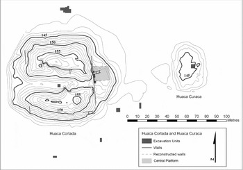
Huaca Cortada (Figures 5 & 6) is composed of a large central mound that is flanked by two low platforms, creating an overall U-shaped layout that encloses a 50 × 60m rectangular plaza (Pozorski Reference Pozorski1976: 299). Surrounding the base of the monument are a number of deeply buried buildings that include ephemeral residential/domestic areas (Nesbitt Reference Nesbitt2012b), as well as small religious structures (Pozorski Reference Pozorski1976: 25–28).
Plan of Huaca Cortada showing the location of excavation units.

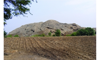
Photograph of Huaca Cortada looking to the north.

The main mound of Huaca Cortada dominates the landscape of the Caballo Muerto region. Measuring approximately 90 × 100m at its base and approximately 20m in height, Huaca Cortada is one of the two largest Initial Period buildings at Caballo Muerto. The mound consists of four masonry terraces, the first two of which are more than 4m in height. The terraces were built from locally available andesite boulders quarried from the nearby hills that surround Caballo Muerto. Each terrace was covered with multiple layers of clay plaster and white paint, corresponding with periodic renovations to the temple architecture over its long history of occupation.
Huaca Cortada (‘cut mound’) takes its name from a large looter's trench that split the mound in half along the length of its east–west axis. The result of this enterprise was the obliteration of the central part of the mound, which would have included rooms on the mound summit, as well as its central access. Although the looter's trench was quite destructive, it also yielded opportunities to examine the construction technique and building sequence of Huaca Cortada. Based on profile cleaning, it is estimated that the total volume of the mound is comprised of approximately 65000m³ of rubble fill (Nesbitt et al. Reference Nesbitt, Gutiérrez and Vásquez2010).
Huaca Cortada was not the product of a single building stage. Chronological information indicates that Huaca Cortada was used as a temple from approximately 1600 BC until at least 1000 BC (Nesbitt et al. Reference Nesbitt, Gutiérrez and Vásquez2010). Excavations placed on the northern side of the looter's trench uncovered two superimposed terrace walls associated with buildings located on the preserved part of the mound summit. The two walls are separated by a boulder fill with the upper wall approximately 1m above the other. The superposition of the walls demonstrates that the height of the building was gradually increased over time, suggesting that Huaca Cortada, as with other Initial Period monuments (Burger & Salazar Reference Burger and Salazar1991), was subjected to cyclical remodelling efforts throughout its long history as a temple. As will be discussed later in this paper, at least some of the construction phases were linked with remodelling or additions following flooding accompanying the El Niño phenomenon. The following section details the contexts of the El Niño proxies present at Huaca Cortada.
Mid-second-millennium BC El Niño proxies at Huaca Cortada
Sedimentary proxies for heavy rains connected with El Niño were found primarily along the eastern façade of Huaca Cortada. The excavations in this area consisted of a trench that exposed: 1) a segment of the surface on top of the lowest terrace; and 2) a large platform addition that abuts the central area of the eastern façade. The excavation of the central platform revealed the earliest sedimentary deposits indicative of El Niño.
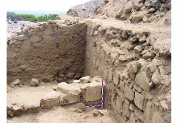
The central platform is a large rectangular addition to the eastern façade that measures approximately 12m in width and 5m in height. Post-abandonment destruction on top of the platform permitted two small excavations designed to clarify the construction of this structure (Figure 7). These confirmed that the platform formed a component of an early Initial Period construction episode that covered the two lower terraces. The platform was filled in with a combination of mud, boulders and a small quantity of adobe bricks. Two sherds were found in the platform fill: a single, long-necked bottle and an enclosed cooking pot, both of which are diagnostic of the early Initial Period at Caballo Muerto. The presence of early Initial Period pottery styles supports the mid-second-millennium BC radiocarbon dates that will be discussed later in the article.
The north side of the central platform wall: 1) post-abandonment staircase; 2) eastern façade terrace wall; 3) post-abandonment fill; 4) rubble fill of the central platform; 5) northern wall of the central platform.

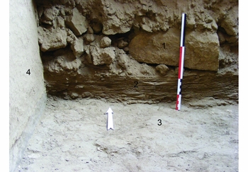
Underneath the platform fill was a grey, plastered terrace floor that dates to an earlier building phase prior to the construction of the central platform. Sandwiched between the terrace surface and the platform fill was a thick layer of light brownish-grey (10YR 6/2) silt with ripple marks on the surface. In profile (Figure 8), the sediments are laminated and measure approximately 100mm in thickness. The laminated structure of the deposits is clearly formed through water action resulting from torrential rains and flooding that only occur on the arid Peruvian coast during strong El Niño events (e.g. Uceda & Canziani Reference Uceda and Canziani1993; Sandweiss et al. Reference Sandweiss, Shady Solís, Moseley, Keefer and Ortloff2009). As the surfaces on which the sediments were found are hydrologically isolated from the natural drainage around the mound, the deposits must originate from rainfall running down the sides of the structure and picking up sediment from the top of the mound, and then redepositing it as the water and sediment settle over the terrace floor. Furthermore, the laminated deposits suggest that the terrace floor was exposed for a short period of time before being quickly covered over (and protected) by the construction of the central platform.
Profile image of the laminated sediments located at the base of the north area of the central platform: 1) rubble fill of the platform; 2) laminated sediments; 3) terrace floor; 4) wall of the eastern façade (scale bar is 30cm).

Dating the earliest El Niño proxy
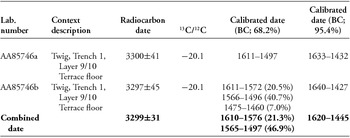
There was no material to directly date the flood deposits underlying the central platform. Nevertheless, because the platform was clearly built immediately following the deposition of the flood sediments, dating this structure provides a close age estimate of the earliest known El Niño event at Huaca Cortada. The trench excavations uncovered the southern retaining wall that forms the edge of the central platform. These same excavations exposed a large segment of the floor on top of the lowest terrace with a series of five superimposed floors, coinciding with periodic remodelling of the temple (see below). The earliest of these floors joins with the central platform and is clearly contemporary with its construction. Marking the abutment of the floor, the eastern façade and the platform was a small twig that was placed horizontally, possibly as some kind of construction marker. The twig yielded two dates of 3297±45 and 3330±41 BP, producing a combined calibrated age range of 1620–1445 cal BC for the construction of the central platform (Table 1). Given that there is strong evidence that the central platform was built immediately following the flooding of the terraces, a date of c. 1600–1450 BC is estimated for the earliest El Niño at Huaca Cortada. This correlates with the period just after the first pulses of monumental construction at Huaca Cortada, and at Caballo Muerto more generally.
Calibrated radiocarbon dates from Huaca Cortada; calibration based on the ShCal13 curve (Hogg et al. Reference Hogg, Hua, Blackwell, Niu, Buck, Guilderson, Heaton, Palmer, Reimer, Reimer, Turney and Zimmerman2013).

Later El Niño proxies at Huaca Cortada
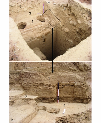
There are sedimentological proxies for subsequent El Niños that affected Huaca Cortada. As mentioned earlier, the excavations of the terrace to the south of the central platform revealed a superposition of five clay-plaster floors (Figure 9a). Each of the final (most recent) three floors is overlain with laminated sediments identical to those described above. The laminar deposits are composed of silt and measure between 90mm and 120mm in thickness (Figure 9b). In some instances, there are very thin layers of white paint within the laminated sediments, which formed as some of the water washed off the painted, plastered surfaces of the terrace walls. At present, there are no radiocarbon samples to date these subsequent events in absolute terms, but pottery found on the surface of the terrace consists of bichrome and monochrome stirrup-spout bottle fragments known to date to the late Initial Period, between 1100 and 900 BC (Nesbitt et al. Reference Nesbitt, Gutiérrez and Vásquez2010). It can therefore be tentatively concluded that Huaca Cortada was affected by several additional El Niño events that probably date to the late second millennium BC, a time when El Niño frequency apparently increased to modern periodicity (Sandweiss et al. Reference Sandweiss, Maasch, Burger, Richardson, Rollins and Clement2001, Reference Sandweiss, Maasch, Andrus, Reitz, Richardson, Riedinger-Whitmore, Rollins, Anderson, Maasch and Sandweiss2007). Moreover, it is during this time that the final construction phases and abandonment of Huaca Cortada occurred.
a) The south side of the central platform and the floors on the top of the lower terrace: 1) terrace surfaces; 2) retaining wall of the lowest terrace; 3) damaged section of the eastern façade; 4) southern wall of the central platform; 5) mouth of the looter's trench (scale bar is 1m). b) Laminated sediments, which post-date the central platform, overlying a later terrace floor: 1) plastered southern wall of the central platform; 2) laminated sediments with thin layer of white paint; 3 & 4) Initial Period floors (scale bar is 30cm).

In sum, there is good archaeological and proxy data to indicate that Huaca Cortada was struck by numerous El Niño events that date to the second millennium BC. The fact that the proxies were so visible in the archaeological record could signify that the flooding deposits at Huaca Cortada were the product of strong or very strong El Niños with high precipitation and damaging floods (Quinn et al. Reference Quinn, Neal and Antunez de Mayolo1987).
Discussion
The role that El Niño played among coastal Andean populations has been the subject of considerable debate in the archaeological literature (van Buren Reference van Buren2001). Writing about this interpretive ‘black box’, Billman and Huckleberry (Reference Billman, Huckleberry, Sandweiss and Quilter2008: 117) state that “[h]uman societies enter one end of the box, El Niño occurs, and societies exit the box transformed in some dramatic fashion”. Yet the information from Huaca Cortada, where there are clear associations between El Niño proxies and architectural phases, suggests that no major transformations occurred during the early Initial Period as a result of El Niño. Furthermore, the chronology of Caballo Muerto as a whole points to an uninterrupted florescence in monument building throughout much of the second millennium BC (T. Pozorski Reference Pozorski1983; Nesbitt Reference Nesbitt2012a). In other words, the data presented in this article confirm observations made by other archaeologists who argue that during most of the Initial Period, the social, religious and economic mechanisms that allowed for the mobilisation of labour for monument construction were not negatively impacted by El Niño (Sandweiss et al. Reference Sandweiss, Maasch, Burger, Richardson, Rollins and Clement2001).
That Huaca Cortada thrived through periods of abrupt environmental shifts during the Initial Period may be explained by the relatively low frequency of El Niño during the early and middle half of the second millennium BC (Sandweiss et al. Reference Sandweiss, Maasch, Burger, Richardson, Rollins and Clement2001, Reference Sandweiss, Maasch, Andrus, Reitz, Richardson, Riedinger-Whitmore, Rollins, Anderson, Maasch and Sandweiss2007). During this time, El Niño events apparently occurred less than once in a generation and the data from Huaca Cortada support this claim. Yet, even at this frequency, strong El Niño events were persistent, hazardous occurrences (Pozorski & Pozorski Reference Pozorski and Pozorski2005: 143; Sandweiss et al. Reference Sandweiss, Shady Solís, Moseley, Keefer and Ortloff2009). How did the ancient inhabitants of Huaca Cortada, and the Caballo Muerto complex more generally, perceive and attempt to counter these kinds of unpredictable events?
In recent years, the archaeological study of human interaction with the environment has emphasised agency-based perspectives that incorporate various human decision-making processes in order to explain how specific societies address sudden or unexpected changes in the climate (e.g. McIntosh et al. Reference McIntosh, Tainter, McIntosh, McIntosh, Tainter and McIntosh2000; van der Leeuw & Redman Reference van der Leeuw and Redman2002; Thompson Reference Thompson2014). Invoking this perspective, Sandweiss and colleagues (Sandweiss et al. Reference Sandweiss, Maasch, Burger, Richardson, Rollins and Clement2001: 605) illustrate the complexities of cultural adaptation to El Niño, stating that, “[t]echnology, history, cultural practices, religion, perception and individual and group idiosyncrasies can all affect the way a society and its members respond to change”.
At Huaca Cortada it is probable that some combination of mitigating actions was undertaken. For instance, the kind of communal social organisation that was periodically pooled for monument building could have been repurposed for irrigation canal clearing. Furthermore, it is conceivable that food exchange networks with unaffected regions in the highlands could buffer against short-term agricultural shortages (Burger Reference Burger and Donnan1985: 277). Yet it is probable that other mechanisms were also at play, particularly in societies where the relationship between culture and nature might be entangled. In this respect, the associations of El Niño proxies with specific building phases of Huaca Cortada permit a deeper discussion of the specific role that temple-based institutions and ritual played in response to potential environmental disasters.
There are indications that the torrential rains, flooding and other environmental perturbations brought on by the El Niño phenomenon were viewed as important supernatural occurrences in the cosmology of ancient Andean coastal people (Roscoe Reference Roscoe, Sandweiss and Quilter2008: 93). As an illustration, there is archaeological (Bourget Reference Bourget and Pillsbury2001) and historical (Rowe Reference Rowe1948: 38–39) documentation that human sacrifices were associated with prolonged periods of El Niño rainfall during the later periods of Andean prehistory in order to placate deities driving the forces of nature.
During the Initial Period, the settlement landscape of the Peruvian coast was dominated by monumental temple architecture. I argue that ceremonial architecture and religious leaders were important elements of the cultural resilience that characterised Initial Period societies at Caballo Muerto and elsewhere. Initial Period temples served a variety of social and religious functions within coastal society, including to dissipate/manage fluctuating supernatural forces, which certainly would have included ecological disruptions (Lathrap Reference Lathrap and Donnan1985). Given the association of many temples with irrigation canal intakes, temple rituals were also orientated towards the maintenance of agricultural production (Williams Reference Williams and Donnan1985; Burger & Salazar 2012). In this light, it is interesting that one of the foci of responses to the different El Niño events at Huaca Cortada was the continual renewal and expansion of temple architecture. Immediately following the El Niño, dated to c. 1620–1450 BC, one of the largest additions to Huaca Cortada was built in the form of the large central platform. Restructuring of the monument during a period of climatic flux might be interpreted as an effort by temple leaders to demonstrate that they could manage and even control the fluctuating forces of nature.
Furthermore, temples were an important symbol of community identity during the Initial Period. Thus, while the dispersed, small-scale settlements in the Moche Valley floodplain were periodically destroyed, forcing people to move to different locations, large monuments such as Huaca Cortada would represent a symbol of community permanence. In this sense, temples would have served as a way of maintaining place, and for this reason were continually renovated by local populations. It has been observed historically that during strong El Niño events, indigenous peoples would retreat to the summits of ancient mounds (Copson & Sandweiss Reference Copson, Sandweiss, Boyd, Erwin and Hendrickson1999: 215). Taking refuge at these types of buildings might be recalling an earlier tradition, where ancient mounds were thought to protect against environmental disaster.
Conclusion
Archaeologists have long realised that disaster is largely a cultural construct (Sheets & Cooper Reference Sheets, Cooper, Cooper and Sheets2012), and that environmental perturbation is only a problem when ancient societies are unable to adjust to it successfully (McIntosh et al. Reference McIntosh, Tainter, McIntosh, McIntosh, Tainter and McIntosh2000). Shannon Dawdy (Reference Dawdy2006: 724) has further stated that human response is mediated by what are perceived to be vulnerabilities, which could be social, economic or religious. In the case of Initial Period Huaca Cortada, some of those vulnerabilities were religious in nature and were responded to in kind through the renovation of temple architecture. These kinds of practices should push archaeologists to explore human-environmental dynamics in a broad manner that takes into account how religion, ritual and ‘symbolic reservoir’ (McIntosh et al. Reference McIntosh, Tainter, McIntosh, McIntosh, Tainter and McIntosh2000: 26–27) can be an equally important means for dealing with abrupt climate change.
The protection of public architecture was an apparent cultural priority during the Initial Period, especially given that many of the largest coastal settlements were located in areas subject to flooding. On the central coast of Peru, the builders of the Initial Period monument of Manchay Bajo built a massive perimeter wall to shield it from repeated debris flows (Burger 2003). For much later time periods in Peruvian prehistory, there have been reported cases of monument rebuilding associated with El Niño events. Examples include major construction episodes of north coast public architecture at Huaca de la Luna (c. AD 400–700) and a late thirteenth-century AD building at Túcume (Uceda & Canziani Reference Uceda and Canziani1993; Narváez Reference Narváez, Heyerdahl, Sandweiss and Narváez1995: 105–106), which point to an emphasis on temple renewal following sudden torrential rains and flooding.
More generally, religious responses to climate change were common in antiquity. Moyes and colleagues (Reference Moyes, Awe, Brock and Webster2009) recently documented how Maya cave rituals apparently intensified significantly during a period of drought in the Late Classic Period in Mesoamerica. Likewise, Arlene Rosen (Reference Rosen2007: 147–48) recently concluded that an increase in temple building in the Levant during the Early Bronze Age (c. 2200 BC) coincided with a decrease in rainfall. The increased investment in temple construction was seen as a correlate for temple priests attempting to convince the population of their control over rain deities. Rosen notes that these attempts at temple expansion ultimately failed because populations put their energies into religious activity rather than other means of mitigating against environmental stress.
This kind of argument is worth taking into account when thinking about Huaca Cortada. As stated earlier, the abandonment of Huaca Cortada was associated with an El Niño that occurred sometime around 1000–900 BC. This abandonment was part of a larger process at Caballo Muerto in which all Initial Period monuments ceased to operate as temples. Subsequent mounds of the early and mid first millennium BC at Caballo Muerto were fewer in number and significantly reduced in size. It is possible that responding through investment in monumental architecture was perceived as an inadequate or failed response as El Niño frequency increased in the late second millennium BC (Sandweiss et al. Reference Sandweiss, Maasch, Burger, Richardson, Rollins and Clement2001, Reference Sandweiss, Maasch, Andrus, Reitz, Richardson, Riedinger-Whitmore, Rollins, Anderson, Maasch and Sandweiss2007).