Introduction
This article examines how locality was conceptualized and performed in Greater London through a series of torchlight processions of costumed individuals and decorated vehicles, often dubbed ‘carnivals’, held in the city and its suburbs in 1900 to raise funds for Boer War-related charities, particularly the Daily Telegraph’s fund for combatants’ widows and orphans. While a substantial body of work now exists on the subject of civic pride and local identity in Victorian Britain, much of this has focused on the provinces, with the capital remaining strangely peripheral to the debate.Footnote 1 Thus, the historiography tacitly endorses through its silence (or in parts openly reiterates) dystopian nineteenth- and early twentieth-century tropes about London as amorphous, sprawling and rootless.Footnote 2 When historians have approached the subject of metropolitan place-based identity, they have instead tended to do so with their focus specifically on London's connections to nationhood and empire.Footnote 3 Yet even during a zenith of patriotic and imperial feeling, such as the Second Boer War, this article demonstrates how a sense of locality remained integral to Londoners’ outlook and as a precursor to voluntary action. Through the prism of contemporary carnivals, their administration and the arguments surrounding them, it reconciles the explorations of social structure and political organization found in earlier histories of London by historians such as John Davis and Gareth Stedman Jones with a focus on issues of identity, representation and discourse, arguing that these were mutually constitutive in the construction of the local as concept and sphere of action.Footnote 4 As a result, ideas and practised versions of locality were dynamic, contested and inherently related to class as both socio-economic category and imagined community.
The article begins by discussing the continuing importance of locality in Victorian London, and its persisting centrality to ideas of class and forms of citizenship, before outlining the proliferation of carnivals in Boer War London and supplying a brief overview of their organizers’ social composition and the broader array of organizations participating in the processions and connected fundraising efforts. Subsequently, it considers how the carnivals’ spread across the capital related to communication networks – principally via local newspapers and the Telegraph – which facilitated the conceptualization and performance of both locality and metropolis as holistic entities. The penultimate section considers expressions of local identity in and around the carnival and how these related to newly established administrative boundaries and overlapping and conflicting senses of locality rooted in nomenclature, community life and physical geography. Finally, it discusses nested class identities bound up with ideas of locality, evinced in selection of procession routes, organizational participation in carnivals and particular local rivalries. Drawing predominantly on local newspaper reports, as well as printed ephemera and census data, the article focuses on five case-studies: the East End Carnival, held in the predominantly working-class parishes that would come to form the metropolitan boroughs of Stepney and Bethnal Green; the Greenwich, Deptford and Charlton Carnival, which represented a more socially mixed area in the south-east of the city; the St Pancras Carnival, which occurred in a more affluent part of north London; the Hornsey Carnival, in a middle-class Middlesex suburb; and the Willesden Carnival, in a more proletarian Middlesex suburb. The social composition of these areas is demonstrated in Table 1.
Percentages of males aged 10 and over resident in host districts of selected carnivals that were employed in different occupational groups, 1901

Sources: Data for Table 1 taken from General Register Office, Census of England and Wales. 1901. County of London. Area, Houses and Population; also Population Classified by Ages, Condition as to Marriage, Occupations, Birthplaces and Infirmities (London, 1902), 102–3, 108–9, 114–15, 138–9, 144–5; General Register Office, Census of England and Wales. 1901. County of Middlesex. Area, Houses and Population; also, Population Classified by Ages, Conditions as to Marriage, Occupations, Birthplaces and Infirmities (London, 1902), 50–1, 54–5.
The remaking of locality, class and citizenship in Victorian Britain
Numerous advancements in communications from the late eighteenth century onwards facilitated greater integration of Britain as a nation, with travel accelerated, first, by the development of new turnpikes and canals, and, secondly, by the spread of railways.Footnote 5 Victorians also saw telegraphy as annihilating time and space and making Britain and the wider world smaller, while following the mid-nineteenth-century repeal of taxes on newspaper publishing, a mass-readership press emerged in Britain, with titles and sales proliferating.Footnote 6 In the wake of these developments, governance also became increasingly national as the central state, despite its laissez-faire inclinations, incrementally intervened in a range of areas, while political campaigning networks became broader and participation in selecting national government wider.Footnote 7
Nonetheless, this process was not tantamount to delocalization. A number of existing studies have illustrated how locality remained integral to the governance of Victorian Britain. Miles Ogborn, for example, rejected a ‘zero-sum’ interpretation of central-local power relations within the state in this period, instead emphasizing that levels of state apparatus were interdependent, specific outcomes that resulted from individual processes of negotiation between them, and the relationship remained dynamic within the operation of policy.Footnote 8 Philip Harling has highlighted how a number of key developments of the late Victorian and Edwardian period were pioneered at the local level, including tackling diseases, experiments in municipalization and female and working-class participation in government.Footnote 9 K.D.M. Snell has also stressed the centrality of the parish during this period, highlighting its importance in a range of aspects of social life, including welfare provision.Footnote 10 Robert J. Morris, meanwhile, explained the growth of the Victorian state within the context of urbanization, noting the shifting of institutions of government from region to municipality, and the way that market failures and health crises arising from urban growth encouraged reform and expansion of urban governance structures.Footnote 11
This is highly apparent in the case of London, whose population both multiplied and dispersed increasingly outwards over the course of the nineteenth century. By 1901, the County of London's population had surpassed 4.5 million, close to five times the number of people who lived in that same area in 1801, while more than two million resided in the more newly built-up districts beyond the County borders designated as London's ‘Outer Ring’, which was more than six times the size of the population of that same area 50 years earlier.Footnote 12 Yet London nonetheless maintained and enhanced its cohesion as a single entity in a number of ways over the course of the nineteenth century. Various bodies were tasked with aspects of metropolitan government during this period – perhaps most notably the Metropolitan Board of Works, established in 1855, and its replacement, the directly elected London County Council, established in 1889.Footnote 13 Economically, London had numerous districts with local concentration of particular sectors, which served the capital as a whole (and beyond), yet that could recruit staff living across London and its suburbs, due to the city's increasingly extensive transport network, augmented by new railway lines and stations and improvements to existing services, as well as the growth of electric trams and motorbuses.Footnote 14
State legislation also facilitated the revitalization of local government at far smaller geographic scales within late Victorian London. Under the 1894 Local Government Act, vestries, which undertook the governance of civil parishes, were abolished outside the County of London and new urban and rural districts with their own councils established instead, supplanting often geographically coterminous sanitary districts and co-existing alongside the earlier established municipal boroughs.Footnote 15 By 1911, there were 71 urban districts and municipal boroughs and 13 rural districts wholly or partially within the Outer Ring area.Footnote 16 Moreover, the London Government Act of 1899 dictated that the 41 parish vestries and district boards of works existent within the County of London be replaced by 28 new metropolitan boroughs, with the first elections to their councils scheduled to take place in November 1900. The vestries which administered these parishes had already undertaken an increasing number of municipal projects since the 1880s, and by the late 1890s a large number of them did support incorporation for largely honorific purposes, along with a limited transferral of powers from the LCC.Footnote 17
Processes of commercial expansion and technological advancement could also buttress rather than diminish the importance of locality. Work by Michael Bromley and Nick Hayes, and by Andrew Jackson, has highlighted how provincial newspapers, though driven by commercial imperatives and their individual political stances, nonetheless provided a key space for the circulation of local information and civic boosterist messages in the early decades of the twentieth century.Footnote 18 While London's local newspapers are badly underused as a historical source, existing research does highlight the importance of the press in meeting growing local demand for news in the capital at this time as well. Michael Harris has estimated that over 350 new titles emerged in Greater London during the 1880s and 1890s alone, by which time outer London weeklies were typically selling between 4,000 and 5,000 copies per issue, inner London papers around 10,000 and ones covering broader regions within London (like the South London Press and Clerkenwell News) approximately 25,000.Footnote 19 Mary Lester's more detailed study of newspapers in north-east London emphasized their overlapping spheres of coverage and circulation, which indicated the complexity of locality and local identities.Footnote 20 Moreover, as Patricia Garside has noted, even the national press frequently afforded extended coverage to local and suburban goings on within London, as commercial pressures forced papers to become progressively more London-centric in their distribution and coverage.Footnote 21
The multiscalarity of place-based identities was also evident in the ritual culture of the era. Simon Gunn has written about the resurgence of civic rituals in mid-Victorian provincial towns, through which the local political classes sought to conflate towns with their local government institutions and leadership, and, though often held to mark national occasions, such as royal visits, were also intended to exhibit local autonomy. These events frequently featured processions as their centrepieces, which emphasized order, continuity and bodily discipline, in marked contrast to the apparent disorderliness of the Victorian streets.Footnote 22 Pageantry, as Paul Readman has demonstrated, also saw communities come together to put on historical performances that fused the local and national past.Footnote 23 Brad Beaven's work on popular imperialism in Portsmouth, Leeds and Coventry has, meanwhile, highlighted the way this too was strongly intertwined with local civic culture, particularly in the case of events held to honour local soldiers during the Boer War.Footnote 24 These institutions were increasingly inclusive, albeit also extremely stratified. As Morris has argued, the expansion of urban governance over the course of the nineteenth century was made possible by the reforming of its structures to become more open and consensual.Footnote 25
The realm of popular culture, meanwhile, was often an object of social conflict through to the mid-Victorian era, its excesses targeted by authorities concerned about the more general prospect of social unrest. Nonetheless, historians of different schools such as Stedman Jones and F.M.L Thompson have long rejected ‘social control’ as a means of explaining cultural changes that occurred over the duration of the nineteenth century.Footnote 26 Such a reading – which assumes dichotomous class conflict and establishment victory as a priori facts – cannot explain cross-class participation in non-respectable local events such as horse-racing meets and Bonfire Night celebrations; nor the support of sections of the working class for their abandonment, and the participation instead of such groups in civic events such as municipal processions and pageantry. Nor does it explain the way an increasingly commercial mass leisure culture, typified by forms such as music hall, successfully appealed across class lines in the late Victorian period, in the wake of relaxation of attitudes towards leisure, reduced working hours and rising real wages.Footnote 27
Yet different classes did not merely share local spaces and formats; rather, they frequently contested them and imbued them with their own meanings. Kate Hill has written of how working-class usage of Victorian museums and galleries for promenading and socializing offended middle-class sensibilities, while Krista Cowman and Richard Dennis have both emphasized how radical, working-class protestors made symbolic capital through the occupation of significant municipal and political sites across Liverpool and London respectively.Footnote 28 Working-class participation in civic rituals, meanwhile, must be understood in the wider context of their battle for legitimacy as part of a wider local community, achieved through various forms of organization and public display. Friendly societies, for example, took a range of measures to improve their image from the mid-nineteenth century onwards and successfully increase their memberships as well.Footnote 29 Their engagement in processional culture and usage of banners and regalia suggested, as Daniel Weinbren has argued, that they ‘could be trusted in public spaces’ and ‘signified sturdy, educated, orderly working class men’.Footnote 30 Nonetheless, this highly visual presence was not universally welcomed, drawing middle-class complaints about their alleged malingering.Footnote 31
Locality was also particularly central to the development of lower-middle-class identity and social relations. This socio-economic group expanded rapidly during the nineteenth century, were particularly heavily concentrated in commercial and administrative centres like London, and, as Geoffrey Crossick has noted, were profoundly local in their social networks, in contrast to the geographically wider connections of the established middle class.Footnote 32 Some historians have characterized the increasing suburbanization of the lower middle class as an abrogation of civic commitment in favour of social distinction.Footnote 33 Yet while broadly committed to the preservation of their status and separateness from the working class and their forms of organization, in many cases the relationship between these two classes was far more nuanced and carefully negotiated at a highly localized level. A. James Hammerton, for example, highlighted that lower-middle-class families often resided in the same neighbourhoods as upper-working-class ones, and that friendship networks frequently crossed this divide.Footnote 34 Christopher P. Hosgood, meanwhile, stressed the important social role that shopkeepers in particular played within the working-class communities they served.Footnote 35 Senses of social difference within the middle class also had spatial implications, with more solidly middle-class, metropolitan writers and commentators frequently deriding the suburbs as sites of mass cultural consumption as a way of maintaining their own sense of distinction. The lower middle class, in turn, often contested middle-class gatekeeping of civic culture and municipal funds through organizations such as ratepayers’ associations, as Kate Hill has demonstrated.Footnote 36
London's Boer War carnivals
Identity formation and social action and organization, therefore, still frequently gravitated to local scales at the end of the Victorian period, and this context thoroughly shaped the organization of the Boer War carnivals, as well as their content and surrounding discussions. Local carnivals – comprising primarily a procession, sometimes supplemented with other entertainments – became an increasingly prominent component of British urban life in the last two decades of the nineteenth century, often held to mark Bonfire Night (though increasingly held at other times of years as well) and almost always with a fundraising purpose, particularly to fund the construction and maintenance of hospitals. Though originally concentrated in south-west England, by the 1890s they had also become common in suburban London too, fuelled in part by the growing numbers of cycling clubs there, which served as avid organizers of and participants in such events.Footnote 37
Drawing upon these precedents, the first Boer War carnival to be held in London took place in the south-east London suburb of Lewisham on 17 and 18 January 1900. Arrangements for this event were put into place during a particularly difficult period of the war, with Britain suffering reverses at Magersfontein, Stormberg and Colenso in December. Carnivals then started to take place in other suburbs in or just outside south London: Brixton and Penge and Anerley in March, Horton Kirby, near Dartford, in April, and in Greenwich, Deptford and Charlton, and in Gravesend in May. British fortunes in South Africa were by this stage taking a turn for the better: Ladysmith and Kimberley, besieged by the Boers since the previous autumn, were finally relieved in February, and then on 16 May, Mafeking was also relieved, prompting huge celebrations back in London, while Pretoria fell to British forces on 5 June. It was against this backdrop of British successes that the carnival movements spread north of the Thames and proliferated across the capital and its suburbs from late May through to early July. This trend subsequently petered out, although a procession was held in St George's and Westminster as late as November. While most of these carnivals were held to raise money for the Telegraph’s fund – and these are listed in Table 2 – there were some partial and full exceptions to this trend.Footnote 38 For example, portions of the receipts from the Bermondsey and Hornsey Carnivals were donated to local funds for soldiers’ and sailors’ families, while the annual carnival held in Tottenham since 1898 in aid of the local hospital had its remit extended in 1900 to raise funds for local war charities as well.Footnote 39 These carnivals were also uniformly limited to London and its hinterland, with evidence from the Telegraph also indicating that fundraising initiatives in other parts of the country took different forms.
Timeline of carnivals held in Greater London and environs in aid of the Daily Telegraph's fund

Source: Data for Table 2 taken from the Daily Telegraph (Jan. – Oct. 1900).
The processions entailed combinations of costumed individuals and groups on foot, bicycle and horseback, as well as horse-drawn cars specially decorated for the occasion. The predominant themes were overwhelmingly military, national and imperial, with a heavy presence of men marching in khaki, model warships and tableaux of Britannia surrounded by the four nations of the Union, as well as often the colonies and dominions – although these were interspersed with more apolitical, entertainment-focused items, such as clowns and pierrots, and decorated vehicles taking sport or fairy tales as their primary motif.Footnote 40 Sometimes spread over two or three days, these evening-time (gas and electrically) illuminated processions embarked along routes through their host districts, with thousands of watching spectators crowding along roadsides, where costumed collectors solicited contributions from them. In many cases, their takings were supplemented with income from other smaller-scale fundraising initiatives, such as concerts and house-to-house collections, as well as from donations.
Carnival movements usually commenced with a number of influential citizens organizing public meetings at which committees were elected to organize a carnival. The most detailed information available regarding membership of these committees comes from Greenwich, Deptford and Charlton.Footnote 41 Here, local businessmen – particularly licensed victuallers, merchants and retailers – were the most prominent members of the carnival's administration, while there were also a number of locally employed professional men such as doctors, solicitors, accountants and journalists involved. However, the lower echelons of the committee system also included a substantial number of workingmen. Information available about other carnivals’ administrations suggests local businessmen and, to a lesser extent, professionals, were highly prominent among the organizational hierarchy there too.
Carnival movements tended to have their basis in the district's existing institutions, in some cases springing from one specific organization. The Lewisham Carnival was first mooted in the Catford Conservative Club, with a number of its members subsequently becoming district secretaries within the movement.Footnote 42 The idea of holding a carnival in Battersea similarly germinated in the Bolingbroke Tradesmen's Association, while local friendly societies were, as will be explained below, instrumental in initiating the Hornsey Carnival movement.Footnote 43 Elsewhere, activists seeking to organize a carnival frequently invited local organizations to send representatives to be elected to the initial general committees. Among those present at the Greenwich, Deptford and Charlton Carnival's first public meetings were the chairmen of Greenwich Conservative Club and the East Greenwich Traders Association, while Greenwich and Deptford's trade unions and friendly and benevolent societies were also invited to send delegates.Footnote 44 Representatives of the Railway Servants Amalgamated Society were similarly present at the first public meeting of the Willesden Carnival movement.Footnote 45 Local government officials also played a key role in the administration of many carnivals. Edward Sinclair-Cox, chairman of the St Pancras Carnival's Central Executive Committee, was also chairman of the St Pancras Vestry, while the committee's secretary, C.H.F. Barrett, and his assistant, Henry T. Richards, were also vestrymen.Footnote 46 The Hornsey Carnival's Executive Committee, meanwhile, was chaired by W.P. Wood of Middlesex County Council, while each of the district committees included representatives from Hornsey Urban District Council; Willesden Urban District Council was similarly represented on the Willesden Carnival's district committees.Footnote 47 The East End Carnival also included London County Council (LCC) member B.S. Straus among its officials, while both the Lewisham and Brixton Carnivals were chaired by local LCC members.Footnote 48
The carnival movements more broadly were heavily reliant on local businesses both as contributors to the funds and as contributors of procession items. Licensed victuallers were particularly active as fundraisers and donors, as well as in providing spaces for public and committee meetings. Theatre proprietors were also able to draw upon a supply of props, costumes and players for allegorical decorated vehicles, as well as using their venues to hold supplementary entertainments. Other important participants in the processions included friendly societies, temperance societies, trade unions, sports clubs, political clubs, bands, voluntary army battalions and branches of youth organizations like the Church Lads’ Brigade and Boys’ Brigade. Political clubs, churches, schools and local government buildings also served as sites for public meetings and committee headquarters.
This framework of support reinforces the findings of Beaven, and others, that the call of nation and empire resonated across class boundaries, though different classes did not necessarily interpret or respond to it in the same way, and its meanings were frequently negotiated and reportrayed within specifically local contexts.Footnote 49 Moreover, its composition and organization also reinforces Morris’ argument that during the nineteenth century, structures of urban governance – including voluntary and private as well as public sector bodies with a stake in the regulation of urban spaces and activities within them – were marked by both expanding bureaucracy and an uneven trend towards authority being rooted in scientific and professional knowledge, rather than merely social status and moral worth, although ownership of capital retained legitimacy as the basis for authority.Footnote 50 Members of national social, political and economic elites – owners of large businesses, colonels, members of parliament – who resided or were based locally were often prominent supporters of the carnivals, speaking at public meetings, donating substantially and, accordingly, being listed as presidents and vice-presidents, but were far less commonly involved in an organizational capacity. Rather, it was those whose status and personal and professional networks had a far narrower geographic remit that exerted administrative power in this instance. The source of this authority lay partly in the tangible resources these individuals could call upon – such as venues for meetings, or vehicles for the procession – but also in their locally recognized human capital and institutional affiliations. Though in aid of a national and imperial cause, the carnivals constituted an institutionalized reiteration of the local spheres of influence of members of the middle, lower middle and organized working classes.
Locality, city, nation and empire
The role of local newspapers in fostering carnival movements is illustrative of how national involvement in an imperial war animated local networks of communication and activity in succession around the capital. They championed the Daily Telegraph Fund and spoke the language of patriotism, but were just as willing to appeal to local pride and self-interest: namely, the presence within their districts of combatants’ families. They also provided a means for carnival organizers to communicate with their wider local community, and furnished details of public meetings, donations and related fundraising efforts, as well as detailed reports of the processions themselves. The Kentish Mercury, for example, covered affairs in Greenwich, Deptford and Lewisham and from late 1899 onwards reported on local war charity fundraising efforts in these areas, including the build-up to the Lewisham Carnival.Footnote 51 Its editor G. Willis then became treasurer for the Greenwich, Deptford and Charlton Carnival, his newspaper thereafter effectively becoming a mouthpiece for the carnival's organizers, frequently extolling the virtues of the Daily Telegraph Fund and each week publishing the names of those who contributed to the local carnival fund. Even after the procession had been held and the various organizing committees had ceased meeting regularly, the Mercury continued to report any contributions to the fund and to call on others to donate.Footnote 52 By familiarizing their readers with the activities of the numerous existing interpersonal and interorganizational networks that supported the carnival, the local press thus constructed the facade of a broader, more unified local public sphere from the complex, fragmented lived experience of community life. This genuine commitment to the welfare of combatants’ widows and orphans, patriotic and imperial duty and local standing was buttressed by commercial imperatives, for conflating the newspaper with a popular local initiative with national and imperial ramifications unquestionably provided a valuable opportunity for expanding and retaining readership.
The Daily Telegraph itself played an even more integral role in stimulating this local activism. Following its establishment of the widows and orphans’ fund in late 1899, the newspaper dedicated substantial space within its pages to describing the various money-raising efforts being made around Britain on its behalf. On 20 December 1899, it reported for the first time on the nascent Lewisham Carnival movement; henceforth, its coverage of the London carnivals became increasingly extensive. This reportage was similar in content to that of the local newspapers, with carnival organizers even frequently writing in to the Telegraph to invite assistance from and supply information to their own local communities – reflecting its particular popularity among London's tradesmen and clerks – as well as to relay their district's achievements to the paper's wider readership.Footnote 53 The penetration of London's growing suburbs by a national medium of communication, and its promotion in this instance of a national and imperial objective, paradoxically made it an effective tool for maintaining local cohesion and interaction in the face of potentially destabilizing rapid movements of population.
A further dimension in the spreading of the carnivals was the role of London as incubator for these movements. While the timing of their proliferation cohered closely with the unfolding of events in South Africa – with increasing numbers of carnivals being held as the war increasingly turned in Britain's favour, prompting relief and jubilation – the geographic pattern of their distribution seems to have been rooted in factors far closer to home. The announcement of plans to hold a carnival in one district frequently preceded the development of similar movements in neighbouring areas. This is evident from the way Lewisham's example was subsequently followed by other parts of south London and suburban Kent, while there were also discernible patterns of dissemination thereafter in other areas of Greater London: for example, carnivals were held in several Essex suburbs during May alone. Lineages such as this would appear to demonstrate the importance of more local means of information dispersion, such as personal connections with neighbouring towns, or local newspapers, whose circulation might include more than one district hosting a carnival, as in the aforementioned case of the Kentish Mercury, while the East London Advertiser similarly covered the parishes that put on the East End and the Bromley, Bow and Poplar Carnivals. There were also numerous instances of local newspapers printing reports of carnivals in neighbouring districts. They point to the existence of broader regions within London encompassing several administratively distinct districts. Yet the spread of the carnivals was not solely over short proximities. With its initial expansions into suburban east, north and later west London, this trend became far more citywide, and physical distances between carnival-holding districts and their imitators lengthened significantly.
The Telegraph played a central role in this process by transmitting information about local carnivals more widely, and identifying them as a primarily metropolitan and, in particular, suburban, phenomenon.Footnote 54 On 13 April, it printed an article on the topic, in which it claimed that London's immense size had meant ‘the great pageants which have given rise to the most crowded and animated scenes ever known in the suburbs have passed with as little attention from outside, as if Brixton and Penge were separated by Babylonian walls from the life of the capital at large’. Yet it also noted that ‘the great boroughs of the North are astir’, and predicted that ‘with the rival achievements of the rival side of the river before them, they will not willingly allow themselves to be surpassed’.Footnote 55 It therefore reiterated tropes about the sprawling capital's fragmentation on the one hand, while recognizing its increasing integration on the other. When it spread the word about local carnivals, it made it more likely that they would draw crowds from elsewhere – in the cases of the Lewisham and Finchley Carnivals, it even provided detailed advice on how to travel to these places from central London – and thereby that visitors would be inspired to hold carnivals in their own districts.Footnote 56 The Telegraph thus helped reconstitute the city as a single entity. Its reports on carnivals repeatedly referred to ‘Suburbia’ or ‘suburban London’, constructing this as a unified, less geographically specific, place.Footnote 57 In doing so, it reinforced these various districts’ awareness of their own growing interconnectedness within the metropolis. Though located some distance away across the Thames, Brixton was a constant reference point within the St Pancras Carnival movement, while further north, in Willesden and in Harringay, mention was also made of the example set by ‘the southern parishes’, as Willesden's organizing secretary, Henry Plomer, put it.Footnote 58 Underpinning this inter-referentiality was a shared dedication to country and empire, as districts of a city whose administrative and economic life was wholly enmeshed within national and imperial networks.
Local identities, local rivalries
With the restructuring of local government on the horizon, many organizers of, and commentators on, Boer War-related carnivals within the County of London felt a successful event boded well for a new borough's future life and administration. This was particularly the case in those new districts being formed from the amalgamation of several parishes. When moving that a carnival be held in the area soon to become the metropolitan borough of Stepney, London County Councillor W.C. Johnson noted that ‘this would be the first opportunity the new borough of Stepney would have of showing its unity, and he trusted they would make the carnival the best in London’.Footnote 59 The South London Press interpreted the success of the carnival in the area to be covered by the new borough of Bermondsey in a similar light.Footnote 60 This partly reflected the integral relationship carnival movements had with organs of local government and local representatives of wider government bodies. Their valuable, multifaceted support served an ideological purpose, helping to firmly associate the carnivals with their localities through these connections with their district's most prominent public figures and spaces. One regular columnist in the Hornsey Journal – alias ‘Phoenix’ – asserted that the appointment of the Islington Vestry clerk as honorary secretary for that parish's carnival would give the event ‘a semi-official character’.Footnote 61 Administrative boundaries could thus shape conceptual parameters of the district and reinforce local identities.
Local identities were often strongly bound up with national and imperial ones, as was evident in the processions themselves. Though these were unsurprisingly dominated by national and imperial motifs, local themes and variations were far from absent from the carnivals. The East End Carnival, for example, included cars representative of a local public house, Spitalfields weavers at a loom, East End children at play and ‘The Fairlop Boat’ – a reference to the East End tradition of taking boats on wheels up to Fairlop in Essex for the annual fair there – while the Willesden Carnival included a car representative of ‘Old Willesden’.Footnote 62 These national and local reference points did not merely co-exist. Some carnival items sought to locate their district within a wider national story. The Willesden procession included a car representative of Kingsbury-cum-Neasden volunteers of 1802, and a carriage carrying Neasden military and naval heroes. Public discussions of the carnivals were also notable for the connections made between locality and country. In its report on the East End Carnival, the East London Advertiser insisted that ‘No one who is familiar with the East End could ever have any doubt as to the loyalty and patriotism of the people in that district.’Footnote 63 The Finchley Press, meanwhile, was incensed when the Great Northern Railway reportedly refused to run special trains to Finchley on the day of its carnival as the event was ‘only a local affair’, which prompted the newspaper to declare that ‘The Company's patriotism is worse than its train service.’Footnote 64
There was also simultaneously considerable autonomy among the smaller districts within areas covered by individual carnivals. This was reflected in the predominant carnival organization structure, composed of committees usually based on wards or other smaller units within the host district and a central executive featuring ward officials, which often reflected a significant decentralization of power. In St Pancras, when Chairman Cox-Sinclair was asked about the issue of cars being duplicated, he replied that ‘the various committees will have their own ideas as to the sort of show they will make. We cannot, you see, dictate to our good friends.’Footnote 65 In some cases, carnivals were even held by single vicinities within larger parishes, urban districts or boroughs, such as by Brixton in Lambeth, or Canning Town in West Ham. The malleability and multiplicity of local identities within the capital was also evident from the way individual carnivals were often given complex titles that fluctuated during the course of the preparations. The Camberwell, Peckham and Dulwich, and the Bromley, Bow and Poplar Carnivals, for example, covered the areas of the parishes – soon to be metropolitan boroughs – of Camberwell and Poplar respectively, yet their lengthier monikers reflected a desire to stress the parts played by individual areas within these districts. Elsewhere, the Bayswater, Paddington and North Kensington Carnival, and the subsequent South Kensington, Brompton, Knightsbridge and Mayfair Carnival, both crossed administrative boundaries. Meanwhile, residents of Blackheath decided to hold their own carnival in late June in tandem with the parish of Charlton and Kidbrooke, having felt unable to participate more fully in the recent Greenwich, Deptford and Charlton Carnival.Footnote 66 This reflected Blackheath's somewhat liminal and independent status: it was located on the boundary between the parishes of Greenwich, Charlton and Kidbrooke, Lewisham and Lee, and had over the course of the previous century developed its own strong associational culture and institutions.Footnote 67
The flipside of this capacity for independent local action was a parochial streak that meant relations within carnival movements could at times be fractious. The procession route – perceived as a mapping of the most significant streets in the area – was a particularly common cause of contention. In the case of the Camberwell, Peckham and Dulwich Carnival, a deputation of Dulwich residents arrived at a committee meeting to demand several more Dulwich streets be included.Footnote 68 There was similar disgruntlement expressed in the build-up to the Bayswater, Paddington and North Kensington Carnival, and, to a lesser extent, prior to the St Pancras procession.Footnote 69 One particularly acrimonious dispute over a carnival route was that between the Muswell Hill and Stroud Green wards of Hornsey. In June, a proposal that the Muswell Hill section of the route be shortened met with hostility from that ward's committee, which wrote to the Hornsey Executive to protest that the shopkeepers and residents of Muswell Hill had contributed considerably to the carnival in the belief it would pass through their district. As a result, the carnival route was not amended, but its resulting lengthiness meant the procession did not reach Stroud Green until extremely late in the evening, with many districts’ contingents in the parade having by that stage dropped out. This resulted in a war of words via the Hornsey Journal’s letters page between the chairman of the Stroud Green and Finsbury Park district committee, District Councillor William J. Fox, the Hornsey Executive Committee chairman, W.P. Wood, and the Muswell Hill chairman, H.S. Chamberlain, who like Fox was also a district councillor.Footnote 70
On two instances, the existence of overlapping localities and alternative local identities resulted in rifts within carnival movements that led to them splitting in two. In the case of the Willesden Carnival, the ward committee formed in Kilburn – which had materialized later than committees set up in other parts of the district – asked for the event to be postponed to a later date and when this request was rejected, resolved to leave the Willesden movement, and establish its own carnival in tandem with the neighbouring districts of Hampstead and Cricklewood.Footnote 71 This decision caused significant rancour, played out in the letters pages of the Willesden Chronicle, and subsequently in a meeting of Willesden District Council, in which C.C. Pinkham, a Kensal Rise councillor and member of the Willesden Carnival's organizing body, rowed over the matter with J. Sabey, a Kilburn councillor.Footnote 72 The sluggishness with which the Willesden Carnival movement spread does suggest some lack of cohesion between the different built-up areas of Willesden, owing to their relative disparateness, as shown in Figure 1.Footnote 73 Within Kilburn, identification with Willesden Urban District was problematized by the fact that part of Kilburn lay over its border in the London parish of Hampstead.Footnote 74 This meant local allegiances were fluid enough to be switched over to Hampstead when the Kilburn wing of the Willesden Carnival movement became dissatisfied. Yet this was not an entirely happy marriage either: at an early meeting of the nascent movement, there was vigorous debate over whether the event should be called ‘The Kilburn, Hampstead and Cricklewood Carnival’, or ‘The Hampstead, Kilburn and Cricklewood Carnival’, prompting the meeting's chairman to remark that ‘poor Kilburn’ was, and always had been, ‘on crutches’.Footnote 75
Ordnance Survey map of Willesden Urban District and the parish of Hampstead in 1896

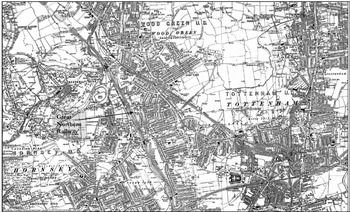
The capacity of the carnival movements to reflect and exacerbate local antagonisms was further demonstrated in Hornsey. Separate carnival movements had initially sprung up in Hornsey and in Harringay – which extended over Hornsey's border into the neighbouring urban district of Tottenham – before they took the decision to merge and then to invite Wood Green to join the fold. However, when the movement fragmented, the Harringay wards remained affiliated with Wood Green, with the remainder of Hornsey holding its own carnival.Footnote 76 This highlighted Harringay's marginal position in relation to the rest of Hornsey, from which it was separated by the Great Northern Railway line that ran through the district and thereby hampered relations between the two sections, which were linked only by a single road bridge – as demonstrated in Figure 2.Footnote 77 Such outcomes of railway development were far from uncommon: railway tracks, yards and stations consumed vast quantities of land in London and other British cities, with an estimated 5 per cent of London's central zone owned by railways at this time, while convoluted crossovers of rival networks’ tracks often resulted in districts becoming encircled, to the detriment of their residents.Footnote 78 The Hornsey Executive wrote to the Harringay, Hornsey and Wood Green Carnival's organizers to request that they keep their procession to the east of the railway line, with the Hornsey Carnival keeping to the west and although this was not acceded to, it highlights the capacity of the built environment to offer alternative, more tangible borders to administrative ones around which local identities could be formed.Footnote 79 It is quite possible that Greenwich Park played a similar role in dividing Blackheath from the rest of Greenwich (as shown in Figure 3), thereby helping to foster an independent sense of identity that manifested in the area holding its own carnival; distance was indeed cited by its residents as one of the reasons they could not play a greater part in the Greenwich, Deptford and Charlton Carnival.Footnote 80
Ordnance Survey map of the urban districts of Hornsey, Wood Green and Tottenham in 1896

Ordnance Survey map of the parishes of Greenwich, Charlton and Kidbrook, and Lewisham in 1898

Class and locality
The Boer War carnivals also constituted an attempt by London's middle and lower middle classes to define their localities and their public spaces in their own image, not least in their selection of carnival routes. For his 1972 study, An Imperial War and the British Working Class, Richard Price set the route of the Battersea Carnival procession against thematic maps of these districts compiled by Charles Booth and his team of social researchers, revealing that the route centred on more middle-class parts of the district and omitted many of its more working-class streets.Footnote 81 I have similarly cross-checked the assumed social compositions of the routes of the Greenwich, Deptford and Charlton, the St Pancras and the East End Carnivals against Booth's maps – with the findings collated in Table 3. These routes were not socially homogeneous, because different classes often resided within relatively close proximity to each other.Footnote 82 Nonetheless, the table highlights the predominance of the second and third echelons of Booth's scale in the carnival routes assessed, which when compared to Table 1 would appear to exceed these social categories’ shares of the broader local population. This underlines the extent to which carnival organizers identified the principal streets embodying their districts as those which mirrored their own social composition, even with the predominantly working-class East End. The selection of carnival routes can be read as a standardizing, linear narrativization of a district's complex matrix of public spaces, against a backdrop of inflows and outflows of migrants and accompanying fluctuations in social tone.
Percentages of streets along carnival routes in which individual social groups were represented, according to Booth's maps

Source: Kentish Mercury, 20 Apr. 1900, 27 Apr. 1900; St Pancras Gazette, 5 May 1900; East London Advertiser, 30 Jun. 1900; C. Booth, Life and Labour of the People in London, 17 vols. (London, 1902–03); J. Steele (ed.), The Streets of London: The Booth Notebooks: South East (London, 1997).
Yet as illustrated earlier, the local middle classes were more than willing to court the support of ‘respectable’ working-class organizations like trade unions representing skilled workers, and friendly societies, whose members were involved in the organization of the carnivals and paraded in the processions themselves. This implies significant support among these groups for the carnivals’ patriotic and altruistic objectives. Yet participating in the shared culture of the carnivals additionally provided a means by which they could stake a place within their own local public spheres. There are certainly elements of this in the nature of trade union and friendly society participation in the processions: rather than sending themed cars, these organizations tended instead to send contingents to march with their banners and (in the case of friendly societies) regalia. For both, parading in these carnivals was an expression of a fused working-class and local identity, demonstrating their loyalty to their local (and national) community and emblemizing their status as an important and legitimate component of that community.
Moreover, representatives of poorer districts also frequently expressed an assertive local identity that stressed the working-class nature of their locality, even though they were usually not working class themselves. When members of the Euston Road district committee sought to present an £8 account to the executive committee for the cost of securing a band for their contingent, they faced fierce opposition from officials from Somers Town, who claimed that being the poorest area in the district, they had themselves simply foregone having a band.Footnote 83 Similarly, in Willesden, the Church End committee came in for severe reproach for reporting a loss; its most ardent critic was Councillor Pinkham of the Kensal Rise committee, who compared Church End's record unfavourably with that of his own district and of Willesden Green, both of which he described as working-class areas.Footnote 84 And in the case of the East End Carnival movement, MP H.S. Samuel told a meeting in his Limehouse constituency that the people of the East End had ‘done far more than their richer brethren in the West End in the cause of charity’, tapping into local perceptions of west Londoners as selfish and patronizing in their attitudes to east London.Footnote 85
Meanwhile, the split in the Hornsey, Harringay and Wood Green Carnival movement occurred amid accusations that local friendly societies had been prevented from electing representatives onto its organizing committee. The friendly societies subsequently formed an integral part of the re-established carnival movement covering the Hornsey area barring Harringay, with 75 per cent of the proceeds from this event to go to the Telegraph’s fund and the remaining funds to support the friendly societies’ own efforts to assist combatants’ dependants in the district. A dispute then arose over the status of the Stroud Green and Finsbury Park wards. The Harringay, Hornsey and Wood Green Carnival organizers held a stormy meeting there on 7 June, at which Councillor Fox accused them of having ignored Stroud Green and Finsbury Park up until that point and warned them against seeking to form a ward committee for their carnival in that area now. When the Harringay, Hornsey and Wood Green Carnival secretary, A.T. Green, ridiculed the idea that they as amateurs could distribute the money as effectively as so great an organization as possessed by the Telegraph, Fox retorted that the friendly societies, ‘whose philanthropic work was so generally appreciated’ could not be placed in so lowly a bracket.Footnote 86 The Hornsey–Harringay schism was, therefore, closely related to attitudes to class and to localism itself: those who supported the friendly societies’ right to a large portion of the carnival's takings were defending the capacity of locally based, working-class institutions to match a more nationally coordinated approach to welfare provision.
The nuances of class may also help to explain Blackheath's collaboration with its neighbouring districts in putting on a carnival of their own: according to Booth's maps, a larger proportion of streets in these areas were categorized as wealthy, whereas the streets where most of the Greenwich committee members resided were ranked as fairly comfortable or well-to-do.Footnote 87 Aspirations over social status also informed the sense of local identity shared by residents of Harringay on both sides of the Hornsey–Tottenham border. At that time, residents of the Tottenham portion of Harringay were actually agitating to join Hornsey, as they resented being part of the otherwise largely working-class wards of Saint Ann's and West Green, and were only placated the following year when a separate Harringay ward was created in Tottenham.Footnote 88 This again reflects the role of class in the complex process of place-formation, especially in the burgeoning suburbs. Local identities, as expressed in the Boer War carnivals, therefore arose partly in relation to the spatial distribution of different social groups, as well as being shaped by how individual carnivals’ primarily middle- and lower-middle-class organizers related to other social classes dwelling in close proximity to them.
Conclusion
Though a relatively short-lived phenomenon in themselves, studying London's Boer War carnivals offer valuable insights into aspects of life in the metropolis and urban Britain more broadly at the turn of the twentieth century. This article has added to the growing body of work arguing that neither the increasing integration of Britain, nor its imperial activities, served to simply minimize the importance of the local. More specifically, it has demonstrated that this was true of London too, and that the capital's physical outward spread, growth and mobility of population, and administrative, communicative and economic development also meant a transformed rather than diminished role for locality in everyday life. The dynamic multiscalarity of place ensured that the contours of locality were remade in conjunction with those of city, nation and empire, as illustrated by the way a sense of London and its suburbs as a single entity, encouraged by a national newspaper, fuelled competition between its different districts in aid of a national and imperial cause, or the way local and national identities were fused in both procession items and the rhetoric surrounding the carnivals. At the same time, the remaking of London's physical, economic, social and political geography also rendered locality unstable, with attempts at local organization revealing contradictory and overlapping conceptions and practices of place at this scale, which could facilitate or scupper an ambitious initiative such as a carnival. In short, locality in London mattered: it was celebrated and contested, even in the context of an imperial war, and thus remained an integral dimension in the co-ordination of collective action.
Locality was, then, a perpetual, shifting performance, which divergent agents with their own agendas had a stake in sustaining or redefining. The administration of carnivals was rooted in pre-existing institutions with partially shared nomenclature and geographic remits: local government, small businesses, branches of trade unions and friendly societies, sports clubs and so forth. Such tacit conceptions of place were materialized and disseminated by local newspapers, which constructed a spatially demarcated public sphere within which other local agents were held up as protagonists and information about their activities shared, and local identity wholly invested in and championed on emotional and economic bases. Developments such as state expansion and suburbanization empowered these same agents, ensuring the continuing and even growing resonance of locality at this time.
Finally, while class formation and consciousness relied to a large degree on regional and national standardization of experience and feeling, locality remained integral in the way different classes operated, and evolved, as groupings unified both by similarity in their accumulations of economic, social and cultural capital and by co-ordination of action. On the one hand, the Boer War carnivals illustrated how shared conceptions and practices of locality facilitated cross-class action in aid of national and imperial causes, as implicitly and explicitly classed organizations and individuals from different occupational groups and socio-economic backgrounds collaborated at this scale. On the other, differing ideas of locality were themselves inherently class-based, reflecting the complexity of London's class structure and social geography. This was evinced by occasions when rhetoric surrounding the carnivals made these connections explicit, or in the selection of procession routes, or frequently in the geographic scope of the carnival movements themselves. Yet above all, the carnivals highlighted the egalitarian possibilities of locality, as a scale at which the lower middle and working classes, still largely excluded from structures of national and imperial government, were increasingly able to exude authority and exercise power, with geographically broader ramifications. They serve as a further reminder that the remaking of Britain as democratic nation and state occurred, to a large degree, from the bottom up.