Scientists have transformed the use and analysis of lidar information in archaeology from an experimental approach to a well-proven methodology. Lidar provides an unparalleled capacity to document cultural landscapes from the air, delimiting features with high accuracy and precision across a variety of lowland settings (e.g., Chase et al. Reference Chase, Chase, Awe, Weishampel, Iannone, Moyes, Yaeger and Brown2014a, Reference Chase, Chase, Awe, Weishampel, Iannone, Moyes, Yaeger, Kathryn Brown, Shrestha, Carter and Fernandez-Diaz2014b, Reference Chase, Reese-Taylor, Fernandez-Diaz and Chase2016; Doneus et al. Reference Doneus, Briese, Fera and Janner2008; Evans and Fletcher Reference Evans and Fletcher2015; Fernandez-Diaz et al. Reference Fernandez-Diaz, Carter, Shrestha and Glennie2014; Hightower et al. Reference Hightower, Swanson and Weishampel2014; Hutson Reference Hutson2015; Rosenswig et al. Reference Rosenswig, López-Torrijos, Antonelli and Mendelsohn2013; von Shwerin et al. Reference von Schwerin, Richards-Rissetto, Remondino, Spera, Auer, Billen, Loos, Stelson and Reindel2016). The impact of lidar has been particularly profound in Latin American archaeology, especially in densely forested zones where traditional ground-based survey requires substantial labor and field time (Golden et al. Reference Golden, Murtha, Cook, Shaffer, Schroder, Hermitt, Firpi and Scherer2016).
Airborne lidar survey reveals previously undocumented details over extensive areas and is more efficient than ground-based reconnaissance (Chase et al. Reference Chase, Chase, Weishampel, Drake, Shrestha, Clint Slatton, Awe and Carter2011). The inventory provided by regional campaigns is potentially transformative, but often raises more questions than answers, and problem-based research requires additional fieldwork. Data quality varies significantly across these campaigns due to differences in vegetation cover, topography, sensor specifications, and processing. Because airborne lidar missions benefit from economies of scale, more targeted missions that could obviate some of these concerns are costly, unless a single deployment can be coordinated to encompass a set of proximate research zones. Acknowledging these issues does not diminish the utility of airborne lidar for prospection and mapping, but is instead a recognition of the need to develop complementary methodologies.
This is precisely why we developed field procedures and tested a drone-mounted lidar system in the Maya Lowlands. These and similar systems can be used as a field-based precision survey methodology complementing traditional airborne lidar prospection surveys. Our research demonstrates that such a system can be deployed quickly to develop detailed surveys of architecture, archaeological landscapes, and ecological conditions. Sampling, mission planning, and data collection standards, however, vary considerably from airborne-focused prospection surveys. Here, we describe two pilot field studies, review the two lidar systems used, report the results of initial data processing, and offer some recommendations for how these and similar systems can be successfully deployed for archaeological studies in Latin America.
Usumacinta River Region
Our pilot study was conducted in the upper Usumacinta River region of the Maya Lowlands. The region is an ideal location to test the system, because of the great variety of land use regimes and diversity of archaeological remains. The region has also been extensively surveyed and studied by archaeologists over the past 15 years. Beginning in 2003, Golden, Scherer, and their colleagues conducted a regional survey complemented by mapping and excavations in the Sierra del Lacandón National Park, Guatemala (Golden and Scherer Reference Golden and Scherer2006; Golden et al. Reference Golden, Scherer and Muñoz2005). This research was expanded in 2010 to include adjacent zones of Chiapas, Mexico (Scherer and Golden Reference Scherer and Golden2012).
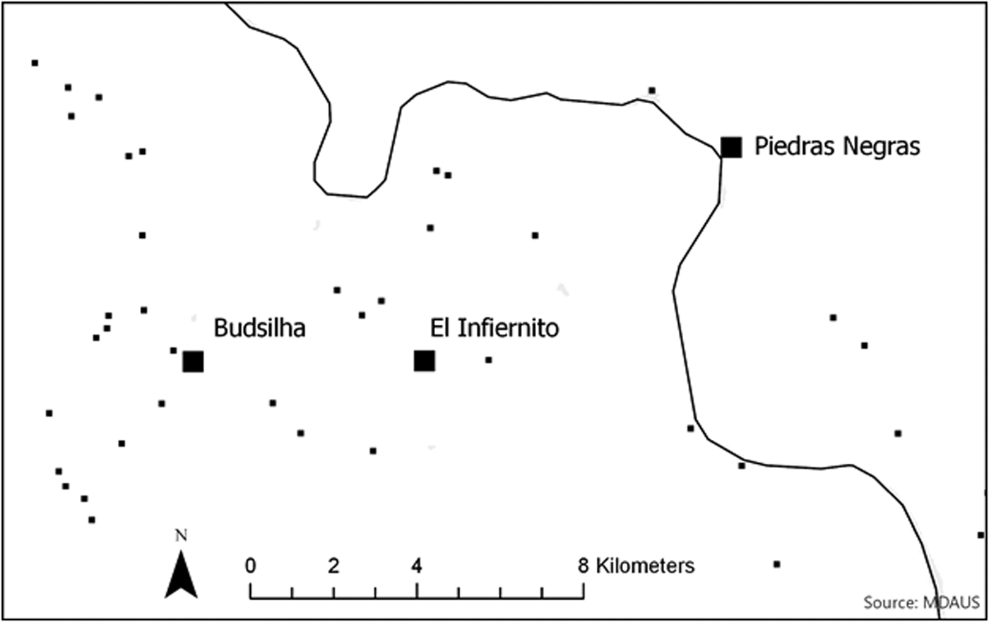
The regional landscape of the Usumacinta is unique to the Maya Lowlands, characterized by diverse ecological niches, resulting in a complex palimpsest of land use, landesque features, and archaeological settlement patterns. The dominant feature is the Usumacinta River. In the area surrounding Piedras Negras, Guatemala, the river cuts through an anticline, creating a series of canyons (Figure 1). The surrounding terrain is generally hilly, karstic topography dotted by numerous tributary rivers, creeks, lagunas, bajos, and sinkholes (cenotes). On the Mexican side of the river, the rugged hills give way to a large expansive valley that runs generally parallel to the river. The scale of archaeological features is also diverse. Monumental architecture dominates the Piedras Negras site core, but a full suite of features from smaller masonry platforms, small terraces, dams, and water catchments (aguadas) to households and low defensive walls are present throughout the region. We attempted to capture a variety of these features and landscapes.
Archaeological sites identified along the Usumacinta through pedestrian survey.

Two Lidar Systems
We deployed two lidar sensors developed by Phoenix Lidar using a DJI M 600 Pro Hexacopter. In 2017, we used a miniRANGER (http://www.phoenixlidar.com/miniranger/) and in 2018, a custom Scout-16 (http://www.phoenixlidar.com/scout-16/; see http://www.gatoreye.org for full specifications). To accurately solve for laser point positions in a mapping coordinate system, observations associated with the positional coordinates of the airborne sensor and the angular orientation of the aircraft were recorded continuously throughout the missions. We estimated the position and angular attitude of the platform using integrated kinematic processing of data collected from an onboard global navigation satellite system (GNSS) unit and an inertial measurement unit (IMU). The sensors were geolocated to ± 2.5 cm using observations from a dual-frequency GNSS unit, with angular orientation obtained using a high-resolution tactical grade IMU (STIM 300) and integrated postprocessed kinematic algorithms relative to a GNSS base station using NovAtel Inertial Explorer software.
Two Drone Lidar Missions
In the summer of 2017, Sam Gerardi and Ira Munkvold from Phoenix Lidar Systems captured data of the Acropolis and surrounding architecture of Piedras Negras, Guatemala (see Figure 1). The purpose of the survey was to test the equipment in the field and develop some baseline standards for data collection. We wanted to test the viability of the technology and quickly compare the results of the survey to the existing map of Piedras Negras. The surveyed area includes a dense concentration of pyramids and palace structures in varying states of preservation, built in the hills and valleys immediately adjacent to the Usumacinta River. The area is also covered by dense tropical forest. Two sets of batteries were used.
In the summer of 2018, building on the experience at Piedras Negras, we systematically mapped two known sites in Chiapas: Budsilha and El Infiernito. Budsilha consists of a rural palace and ancillary buildings, whose occupants were probably courtiers of the Piedras Negras kingdom in the seventh to ninth centuries AD. The site is centered on a single vaulted monumental structure located on a hillock within a swamp that seasonally floods. El Infiernito represents the remains of a small hinterland settlement located atop a steep ridge that was modified with terraces and walls. The custom GatorEye system was deployed at these two sites. One day was spent at each site, and a systematic 25 m survey-transect grid was captured. We relied on 16- to 22-minute flight times while rotating three sets of batteries. During flights, batteries sets were recharged to maximize the number of flights that could be completed each day, with up to 18 flights possible during a 6-hour flight window.
Field Results: The Flights
Minimal flight planning in 2017 required significant adjustment to flight plans and adaptation to on-the-ground conditions. For example, downed trees created new opportunities for launching through holes in the canopy or conversely made takeoff and landing impossible. The canopy and terrain limited controller-to-drone connectivity, thereby restricting range to less than 500 m. The Phoenix team did not want to fly preplanned flights without 100% connectivity to the drone. Our experience at Piedras Negras suggested that, even though this technology is adaptive, preparation and planning before arrival are necessary and would positively affect data quality.
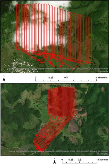
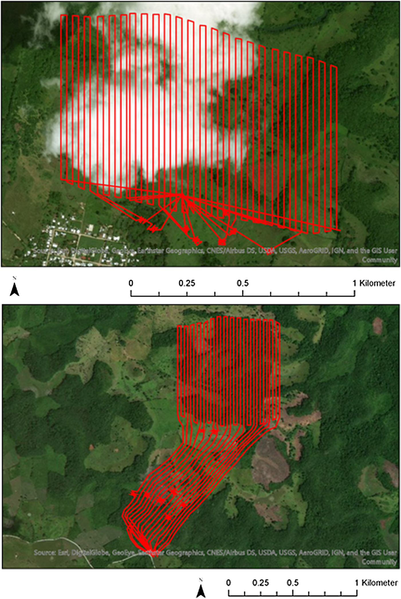
The two flights in 2018 were planned in advance and focused on the systematic acquisition of data to test methods for filtering and processing raw lidar data. Although archaeological sites in Chiapas are covered by forest canopy, adjacent areas are largely deforested, allowing for more adaptive changes to takeoff and landing than at Piedras Negras. Takeoff and landing were adaptive, but flight paths over the sample area were predefined and uploaded to the drone so that 100% controller-to-drone connectivity was not required. We spaced flight transects 25 m apart so that we could follow up and quantify how the system would respond to fewer transects under different vegetative cover (Figure 2). These tests are still ongoing.
Flight paths for Budsilha (top) and El Infiernito (bottom). Infiernito is clustered along the top of the horseshoe shape ridge. Due to accessibility, the drone takeoff and landing location (red lines to the SW) was located 1.35 km to the southwest.
Field Results: LAS Statistics
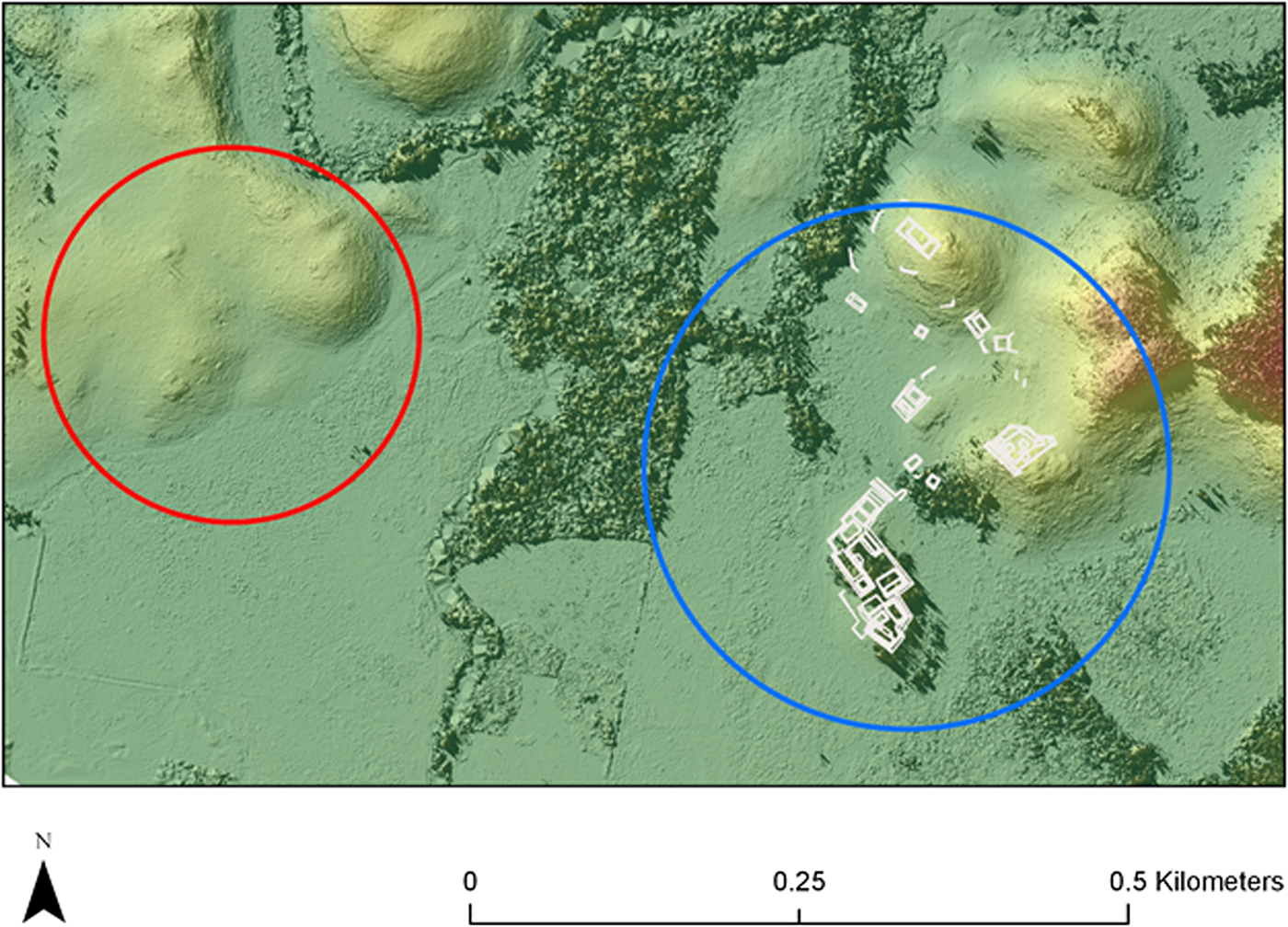
In this section, we report only basic postmission processing. In the Budsilha and El Infiernito missions, we captured approximately 370 million and 340 million points, respectively. For Piedras Negras, approximately 55 million points were acquired (Table 1). Each of these samples were processed using LAStools (Isenburg Reference Isenburg2014): lasground_new64, using a natural filter and default settings. Using filtered ground points, we generated digital elevation models (DEMs) in ArcGIS Pro 2.2 using the .lasd to raster tool (Figure 3).
File Statistics from the Three UAV Lidar Missions.

Sample of processed lidar DEM from Budsilha (highlighted in blue). The precision lidar data will enhance the existing map of Budsilha by documenting additional features like small terraces and aguadas and also by enhancing geographic correction. For nearby sites like La Esperanza (highlighted in red at right) the precision mapping offers high resolution data to reference and complete existing sketch maps.

In total, the quantity of data collected and the results of basic processing mark these three missions as successful, demonstrating that surface topography can be mapped in the Maya Lowlands using drone lidar. Mission planning and transect spacing clearly benefited the 2018 missions, resulting in substantially more ground points and spatial coverage. Further analysis will better measure the potential applications of the data. Based on these surveys, we can confirm that 1–4 km2 of vegetated land cover can be precisely surveyed daily by the GatorEye system in lowlands with dense canopy cover, with processed horizontal spacing of 10–15 cm. The precision capabilities of this survey methodology are potentially unmatched in terms of adaptive field capacity, efficiency, precision, and accuracy. The unique ability to carefully define and delimit the parameters of each mission should not be understated. This is a precision archaeological tool.
Conclusion
Our initial results are promising, and further processing will reveal more about the specific successes and challenges of this pilot study. Here are our initial recommendations and conclusions:
• Drone lidar is not a replacement for airborne lidar, but is a complementary tool for precision survey in the lowlands.
• The survey method, accompanied by mission planning, still offers adaptive field use.
• Relatively large areas with high levels of detail can be surveyed, but processing the data effectively requires field inspection.
• The technology allows data collection and samples to be defined by research questions.
• Similar to airborne lidar, substantially more data are collected than needed to generate bare earth surfaces. Strategic interdisciplinary partnerships can enhance the use and interpretation of these data.
Drone-mounted lidar systems offer significant benefits to research in the region. Drone data collection can be easily adapted to fine-tune data collection based on different vegetation regimes. Height above canopy, transect spacing, and speed can be altered to increase or decrease point spacing to provide effective penetration through gaps in vegetation. Data collection can also be readily tailored to specific archaeological questions and features, so that a tightly planned mission can be focused on problem-oriented research. Airborne lidar has transformed Latin American archaeology in ways that are still unfolding (Chase et al. Reference Chase, Chase, Awe, Weishampel, Iannone, Moyes, Yaeger and Brown2014a). These data are raising new questions about settlement patterns, population, and land use. Now, it is necessary to adapt lidar and use it as a more diverse tool, just as it has been used in ecology to answer some similar questions. Using drone lidar offers promise for rapidly mapping and precisely documenting archaeological landscapes and features.
Acknowledgments
In 2017, research was permitted by the Instituto de Antropología e Historia (IDAEH) y el Departamento de Monumentos Prehispanicos (DEMOPRE) de Guatemala and supported by grants from the National Science Foundation (BCS-1505483/1505399) and the Alphawood Foundation. The 2018 research was permitted by Instituto Nacional de Antropología e Historia de México (INAH) and funded by the Alphawood Foundation. Support for this research was provided by the Center for Latin American Studies and FIBER at the University of Florida. Special thanks to Phoenix Lidar Systems for providing their time, equipment and expertise, particularly the support of Eric Agnello, Sam Gerardi, and Ira Munkvold.
Data Availability Statement
Data will be used and stored for exclusive use by project personnel during the proposed project term and for up to three years. After this period, all data will be permanently stored and accessible from the gatoreye repository at the University of Florida (http://www.speclab.org/data.html).