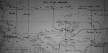



In 1771 Captain Nicolás de Lafora of the Royal Corps of Engineers ordered a composite map constructed of the northeastern frontier of the viceroyalty of New Spain with the southern plains at the center. Surprisingly, the most powerful Native peoples in the region, Apaches, Comanches, Wichitas, and Caddos, were all missing from the middle of the map, which corresponds to the northern two two-thirds of modern Texas (see Figure 1).Footnote 1 This was not a case of European ignorance of Native cultures and their territorial borders. Having accompanied the Marqués de Rubí on a two-year inspection of New Spain's northern frontier from 1766 to 1768 and written the expedition's field diary, Lafora possessed extensive knowledge of the region's ethnography and geography. He recognized that allied eastern Apache bands, whom Spaniards called Lipans, Natagés, Mescaleros, Faraons, and Jicarillas, had routinely fought confederated Comanches, Wichitas, and Caddos for access to the vast bison and wild horse herds and control of the pasturage and political economy of the southern plains. Rather than attempting to depict accurately the complexities of overlapping Native and European territorial claims on the ground, Lafora and his draftsmen were delineating a more rational and orderly imagined regional reality based on the Marqués de Rubí's policy recommendations of 1768.Footnote 2
Rubí advocated that Spaniards form an alliance with Comanches, Wichitas, and Caddos against Apaches, and this map simply showed the presumed successful outcome of the policy with Comanches confined north of the Red River and eastern Apache groups camped closer to Spanish settlements along the Rio Grande valley. In practice, Spaniards failed to carry out Rubí's recommendations, which most infamously advocated a policy of extermination for Lipan Apaches. But scholars have missed that crucial point and commonly refer to Comanches singlehandedly defeating “the Apaches” and pushing them to the margins of the southern plains. As a result, they have underemphasized the extent of Apache sovereignty and territory across the Southwest.Footnote 3
Detail of Nicolas de Lafora's 1771 map depicting the outcome of the Marqués de Rubi's 1768 policy recommendations, with the heart of the southern plains as unoccupied space and eastern Apache groups and Comanches confined to its margins.

From their own observations, Lafora and Rubí both understood that Apaches, who call themselves Ndé (“the people”), were a formidable trans-regional power. Far more extensive than Lafora's map revealed, Kónitsąąhįį gokíyaa (Big Water Peoples' Country), which Spaniards called the Gran Apachería (Great Apache Country), stretched for more than seven hundred miles across the southern plains and southwest from the Colorado river of modern Texas to the middle Gila river of modern Arizona, and Ndé people today still regard it as their “inherent and customary homeland.” Lafora put it most succinctly five years earlier, when he noted Apaches “are situated along [Nueva Vizcaya's] entire frontier from the province of Coahuila to Sonora.” According to Rubí, Lipans lived on the upper and lower banks of the Rio Grande near “abundant springs” and joined together with neighboring Natagés “from the Santa Rosa Range and old time habitations of the Tobosos” to the west for raids on Spanish haciendas in Coahuila and Nueva Vizcaya. The officers observed that Mescalero habitations stretched from the confluence of the Rio Grande and Pecos rivers in the east to El Paso del Norte in the west. Faraons lived in the Sierra Blanca, the Siete Rios range, and at Soledad and San Agustín springs east of the Organ Mountains, and Jicarillas lived in the Sandia mountains and Pecos river valleys. Despite the risk posed by Comanches, Wichitas, and Caddos, all five of these eastern Apache groups were fully capable of traveling north and east to hunt bison, and often united to do so, sometimes in combination with missionized Apaches de paz (peaceful Apaches) or even Spanish troops. Mescaleros, Faraons, and Jicarillas also routinely traveled west of the Rio Grande to hunt, gather, and raid, sometimes in conjunction with Mimbres and Gila Apaches. Lafora, however, omitted all Apache groups residing west of the Rio Grande – today's Southern and Western Apaches – from his map. Gila territory alone extended across most of modern New Mexico and northwestern Nueva Vizcaya, from the Mogollon range north of the Gila river's headwaters southward to the ranges of the western Sierra Madre surrounding Janos presidio and eastward to the Mimbres mountains (today's Black Range).Footnote 4
This is simply one example of a much bigger problem in the historiography of early North America. It is easy, based on a straight reading of European maps, treaties, and documents, to underemphasize the complexity and extent of indigenous territoriality – political control of territory – at the expense of imperial and state power, or, in the case of Lafora's map, simply uninhabited wilderness.Footnote 5 Traditionally, historians of early North America were more concerned with how Indians related to Europeans than with how Indians related to their natural environment or homeland. Even those who have attempted to compare Indian and European conceptualizations of territory have often inaccurately assumed that property, ownership, and politically bounded space were exclusively European concepts that more “primitive” indigenous cultures lacked, rather than recognizing the universality of such concepts among all societies and that Europeans and Indians simply employed them differently. Yet, as historian Donald L. Fixico (Shawnee, Sac and Fox, Muscogee Creek, Seminole) has shown, understanding how Native peoples conceptualize their homeland is absolutely critical for scholars attempting to write from an indigenous perspective because it constitutes the basis of their worldview.Footnote 6 With a few notable exceptions, it is only recently that historians have begun to take indigenous territoriality seriously in their works, and there is still room for improvement. This essay explores the roots and development of this historiographical trend, which includes individual and communal ownership of property and indigenous political domains. Rather than offering a completely comprehensive overview of scholarship from time immemorial to the present, its primary purpose is to highlight the importance of viewing territoriality from an indigenous perspective and encourage more scholars in American studies to adopt such an interdisciplinary focus in their works.
For decades, beginning in the late 1950s, anthropologists and cultural geographers were much more concerned about how Native peoples conceptualized, occupied, and utilized land than most historians were.Footnote 7 But in his award-winning environmental history Changes in the Land (1983, 2003), William Cronon drew from those and other disciplines to provide a cogent and comprehensive regional overview of Native understanding of property in the seventeenth century. Interestingly, Cronon himself has acknowledged that the entire chapter “Bounding the Land” treating this issue and forming the heart of the book's argument was a later addition to the manuscript “in response to constructive criticism.” This and the fact that his original paper in Edmund Morgan's graduate seminar at Yale “said nothing at all about property” reinforce the idea that historians were late to the table on this subject. Relying on economics, anthropology, legal theory, and colonial history, Cronon refuted the widespread belief that Europeans owned land and Indians did not in a mere twelve pages. Like English colonists, Native peoples had a property system that distinguished between collective sovereignty or possession by communities and individual ownership or possession by individuals and families. And just as town proprietors, village sachems (leaders) “held all land in common” and divided the land into specific uses from woodcutting to corn planting.Footnote 8
According to Cronon, however, the similarities ended there. In contrast to proprietors, sachems determined the territorial rights of a village through kin relations within their sovereign group and in opposition to the territorial claims of others. And unlike English colonists, what Native individuals, families, and communities actually possessed were seasonal “usufruct rights” or the right to engage in a specific activity in a particular location, such as planting, hunting, or gathering at the appropriate time of the year. Moreover, in contrast to English property rights, indigenous usufruct rights frequently overlapped, with different groups having “different claims to the same tract of land depending on how they used it.” Cronon called this an Indian system of “land tenure” rather than “territoriality,” but he meant essentially the same thing.Footnote 9
For the rest of the 1980s Cronon remained something of a lone wolf among historians of early North America on indigenous land tenure, but indigenous territoriality continued to be a central concern of anthropologists and cultural geographers. Patricia Albers and Jeanne Kay's book chapter “Sharing the Land: A Study in American Indian Territoriality” (1987) is an excellent example. Focussing on the northern plains and western Great Lakes from 1650 to 1750, these authors argue that, in contrast to the clearly delineated borders of European nations, “Long-term patterns of intergroup ‘sharing’ of lands and resources” were widespread “in American Indian territories.” As was often the case for the Iroquois in the Northeast and Apaches and Comanches in the Southwest, Albers and Kay point out that sometimes stronger groups invited weaker groups into their own territory for “subsistence, ceremony, trade, [and] defense.” They also acknowledge, however, that in other cases Native peoples bound by kinship performed these activities together across landscapes with “ambiguous or non-existent” boundaries. Humbly acknowledging that scholars in 1987 did not understand how American Indians “conceptualized their territorial claims,” Albers and Kay recommended that scholars view indigenous land use from a regional perspective rather than a tribal one and “distinguish between ideological claim to and the actual use of a specific territory.” Ironically, this is exactly what Cronon had already done for New England in Changes in the Land. Yet Albers and Kay did not cite it in their essay. On the northern plains, “clearly differentiated and divided territory,” they argue, emerged only after tribes entered into treaties with the US and Canadian governments to lay claim to trapping areas for the fur trade. Like Cronon, Albers and Kay determine that indigenous territory was often held in common and “changed over time,” as tribes seasonally migrated, and expanded or contracted their territory through warfare.Footnote 10 Although historian Richard White commented on Albers and Kay's book chapter and cited it in his classic The Middle Ground (1991), he devotes only a few sentences to explaining how Native peoples conceived of their territory in the Upper Great Lakes, concluding that wars with the Iroquois had eradicated tribal distinctiveness among Algonquian refugees to the point where they resided in mixed villages, and that determining distinct tribal territories “was both impossible and meaningless.”Footnote 11 It would take historians more than twenty years to revise White's interpretation of this region.
During the 1990s, anthropologists and cultural geographers remained more concerned with indigenous territoriality than historians were. Nevertheless, in his award-winning Wisdom Sits in Places (1996), cultural anthropologist Keith Basso critiqued both groups and the social sciences generally for not paying sufficient attention to “place and space.” Drawing on Indian activist and lawyer Vine DeLoria's fundamental argument that “to name the land was for many Indians a way of claiming it,” Basso called for scholars to engage in more “ethnography and ethnographic fieldwork” as a corrective. Basso himself spent eighteen months over a five-year period traveling through the Apachería with Western Apaches to view their sacred sites, talking with them on Cibecue Reservation about their place names, and observing their territory on their own hand-drawn maps. Basso found that Western Apache place names, such as “Trail Goes down between Two Hills,” had a pictorial quality to them that provided a vivid visual reminder of each location and concludes, “People, not cultures, sense places.” Although incorporating historic Native place names can unquestionably enhance scholarly understanding of Native territoriality, they are not always recoverable and by themselves they seem woefully inadequate for understanding the vast landholdings of the most powerful North American indigenous groups.Footnote 12 It would take historians a long time to heed Basso's call; however, ethnohistorians are increasingly including Native place names in their works, and some, such as Karl Jacoby in Shadows at Dawn, have done so with remarkably good effect in in recent years.Footnote 13
Even more forcefully than Basso, in “Indian/White Relations: A View from the Other Side of the Frontier” (1997), cultural anthropologist Alfonso Ortiz (Tewa) called for historians of Indian–white relations to rethink their “standard historical concepts and categories.” Singling out “Western civilization,” “frontier,” and “wilderness” as three of the most notorious terms for neglecting “indigenous heritage,” Ortiz explains that all three “have always been described by persons from the East, facing westward,” and “assume that civilization and culture are dispensed … only from the East.” In this context, Ortiz describes the importance of place to Indian peoples as “the sense of belonging to and being at one with the land” and explains that “Indian people extend kinship to all living things in their environment, sometimes even to the sun, moon, and stars in the heavens.” Using the people of Taos Pueblo's struggle in 1968 “to regain title to their sacred Blue Lake area” as a case in point, he reveals, “The story of my people and the story of this place is one single story … We are always joined together.” Indians, according to Ortiz, “live in unbroken communities.”Footnote 14
But for the next decade after Wisdom Sits in Places appeared, most historians of early North America paid scant attention to Native territoriality.Footnote 15 Instead the predominant trends were to focus either on the territorialization of nation-states or on how borderland peoples crossed, manipulated, adapted, and circumvented the imperial and national borders that resulted from that process. The vast majority of historians focussing on borderlands peoples were more concerned with human agency and cross-border social and commercial interaction than with the ways these groups conceived of land itself.Footnote 16 Perhaps most infamously, Latin Americanist Jeremy Adelman and western historian Steve Aron argued that Indians “exploited … differences” and “compelled shifts” in order to “resist submission” and “negotiate intercultural relations more to their liking.” But their teleological argument that borderlands progressed into bordered territory of the nation-state ignored the ability of Native peoples to retain large territorial expanses of their own and also failed to consider how they conceptualized their territory, relegating these so-called “people in between” to merely occupying “the lands in between” competing European empires and bordering nations.Footnote 17 Issuing a scathing critique of Adelman and Aron's viewpoint, historians Pekka Hämäläinen and John R. Wunder rightly called them out for “ignoring Indian agency” and Native peoples' ability to “create, machinate, initiate, and control.” However, they offered no specifics on Indian conceptualization of territory or its extent at a tribal, regional, continental, or hemispheric level.Footnote 18
Several exceptions to this trend stand out among the works of scholars of Spanish–Indian relations in early North America. In her anthropological history of Sonora, Wandering Peoples (1997), ethnohistorian Cynthia Radding argues that ethnic space for Sonoran tribal peoples “was centered in the community” and contained a spiritual dimension. Echoing Ortiz, Radding explains that “highland villagers united their ethnic territory with the gods' domain over natural features like mountains, rivers, caves, springs, and the sea.” And as Cronon maintained for Algonquians in New England, Radding reveals that Sonoran indigenous peoples such as Eudeves and Opatas “had two separate principles of land tenure: collective ownership and private usufruct.” Each Native community held arable land in common and by consent could grant individual households the right to use farming plots or milpas “and the water to irrigate them.” In contrast to the fixed boundaries of European land grants, milpa property boundaries shifted seasonally because they were situated on the floodplains of rivers.Footnote 19
In Bárbaros: Spaniards and Their Savages in the Age of Enlightenment (2005), historian David J. Weber viewed the indigenous peoples of the Americas from a Spanish imperial perspective, but still had useful things to say about the extent of their territoriality. Encompassing Spain's entire American empire, the book broke new ground by placing Native responses to Spanish Indian policy in a comparative hemispheric context and demonstrating that unincorporated Indians on Spanish American frontiers not only retained power over their own lives but still controlled more than half of the land mass in the Americas in the mid-1700s. Comanches, in particular, he noted, dominated most of the southern plains, a 240,000-square-mile expanse that is “larger than all of Central America.”Footnote 20 It would be up to scholars of early North America to fill in the remaining parts of the hemispheric picture.
In the same year, anthropologist Cecilia Sheridan expanded scholarly understanding of indigenous territoriality in her essay “Social Control and Native Territoriality in Northeastern New Spain” in Jesús F. de la Teja and Ross Frank's edited volume Choice, Persuasion, and Coercion: Social Control on Spain's North American Frontiers (2005). Sheridan was one of the first scholars in any discipline to offer a clear definition of Native territory and she did so in a book accessible to historians, thanks to David Weber and SMU's Clements Center for Southwest Studies. Sheridan, drawing from obscure Spanish-language anthropological sources, defines Native territory “as a continuous, diverse whole that was rationally utilized by its inhabitants,” and she elaborated that territory, “in this sense, is defined as a set of spaces – hunting, fishing, gathering, ritual, worship, exchange, in which a strategy of integrated management of the land is observed.”Footnote 21
More problematic, in my view, is her conception of “new territoriality,” in which she argues that Indians were capable of asserting control over resources on lands controlled by Europeans but apparently not the territory itself. When Indians raided for “livestock, grains,” and captives, and burned crops and buildings and destroyed animals, she argues, they were expressing “a new territoriality … that is independent of the control of specific territory.” While Sheridan's behavioral model is valid for resource raids, it does not accurately describe indigenous acts of war. When Indians burned crops or buildings, or slaughtered entire livestock herds, they were attempting to drive encroaching Europeans off land that that they recognized as their own or were even trying to expand their territory, and they were often successful. She is more accurate in concluding that Spaniards created “islands of settlement” with fixed boundaries and that Native peoples used mobility and geographical knowledge to maintain control of their lands.Footnote 22 Here again, however, Apaches, Comanches, and other powerful equestrians frequently eradicated many of those islands.
Simultaneously, historians of British–Indian relations began devoting increasing attention to indigenous conceptions of property and territoriality in their broad syntheses and monographs on early North American history. In American Colonies (2001), historian Alan Taylor contrasted Native and European conceptions of property in seventeenth-century New England. Indians moved seasonally and had limited possessions, while English colonists “lived and worked on substantial properties” with “frame houses and barns” surrounded by “fenced fields grazed by privately owned animals.” Algonquians, Taylor contends, “did not own particular parcels of land as exclusive, perpetual, and private property.” Like Radding, Taylor finds that Indians “preserved most of their domains as a commons for hunting and gathering” and that individual families could obtain rights to farming plots and hunting territories. But, in this case, tribal leaders, rather than the entire community, held the power to grant access to these resources, and they did so on an annual basis, rather than for a more extended time period.Footnote 23
In Facing East from Indian Country (2001), historian Daniel K. Richter opened by stating the obvious. Prior to 1776, “the vast majority of eastern North America … was clearly, Indian country.” He acknowledges that the Native population east of the Mississippi river declined precipitously from perhaps more than 2 million in 1492 to less than 250,000 by 1750. In contrast to the vast majority of his contemporaries, however, he still emphasized Native persistence. “The vast area between the Appalachians and the scattered French outposts on the Mississippi,” he argues, “remained almost entirely in Indian hands” until 1820. Although Richter offers a Native perspective on the geography of early America in noting that the Mississippian urban center of Cahokia near modern St. Louis “was probably the largest American city that existed north of Mexico before the late eighteenth century” and highlighting its large population, impressive architecture and agriculture, and extensive trade networks, he did not initially address how Cahokians or other Mississippian peoples conceptualized their territory. Not until the early seventeenth century, when European colonists began dispossessing Indians of their lands along the eastern seaboard, does Richter reveal that Native people viewed their land as a resource instead of a commodity and that Native kin groups and villages, rather than individuals, owned the right to use that resource for certain purposes, including hunting, fishing, farming, gathering, lumbering, and building.Footnote 24
Delving deeper than Richter, Colin G. Calloway made excellent use of Native oral history to foreground a Native perspective on the North American landscape in his One Vast Winter Count (2003). Just as Richter did for eastern North America, Calloway begins by conceiving of the early American West as “Indian country,” which consisted of “a series of Indian homelands” where “Indian communities moved, mingled, and adjusted to new environments, other Indians, and eventually Europeans.” What sets Calloway's work apart from Richter's, however, is the chorus of Native voices in his prologue arguing for their inextricable connections to their respective homelands. Relying on anthropology, Native American literature, oral history, and oral tradition, Calloway explains that since Native peoples believe that their cultures and histories originated from the landscape of their homelands from time immemorial, they have a closer relationship with their territory than do Europeans. Drawing in part from Basso, Calloway reiterates the importance of Native place names and sacred sites to their understanding of territory, and he finds that they use these names to record locations, natural features, animal life, and where to utilize the same kinds of resource for subsistence, ceremonial, and architectural purposes delineated by Richter. His most original contribution, however, may be his explanation of how Native peoples visualized their territory through images and maps. Pawnees, for example, conceptualized the topography of the central plains as “a series of vivid pictorial images” at their sacred sites; Northern Shoshones constructed three-dimensional maps out of sand; and virtually every group created two-dimensional maps by painting them on deerskins and buffalo hides, etching them into bark, or simply drawing them on the ground. Native maps were distinct from European ones because they were constructed from memory and consisted of “patterns of intersecting lines” rather than “fixed points within a bounded space.”Footnote 25
Following these overarching historical syntheses of early North America, professor of law Stuart Banner's How the Indians Lost Their Land (2005) brought newfound clarity to indigenous notions of property in the colonial era. Defining property as “the intellectual apparatus by which a group of people organizes who will get which resources located on which land,” Banner maintains that, although societies organized property differently, every known society in world history had the concept. In his opening chapter, “Native Proprietors,” Banner pushes this point forward for Native peoples, covering more ground more efficiently on the subject than any scholar in any work since Cronon in Changes in the Land. By the late seventeenth century, he argues, in contrast to Cronon, imperial and colonial British officials “normally recognized the Indians as owners of their entire territories, including hunting grounds and other uncultivated areas,” and that they would have to purchase indigenous land to acquire it. Firsthand English observers, such as Increase Mather and William Penn, Banner argues, “referred to the Indians as the ‘Native Proprietors’ or the ‘Owners’ of North America.” Paradoxically, however, some of these same English colonists, including Penn, routinely denied Native claims to uncultivated land, while others inaccurately alleged that Indians “had no notion of “property rights in land” because they were nomadic.Footnote 26
Of course, the reality is that along the Atlantic coast all Native peoples farmed. As historians from Cronon to Richter had demonstrated and Banner confirms, sachems not only knew their collective external tribal boundaries but also set individual property boundaries for each farming family to plant. In contrast to the English system of property, entire Native agricultural villages could move every few years as a result of soil depletion. Yet sachems clearly recognized that unoccupied land lying fallow for future cultivation was still fulfilling a purpose and remained part of their territory, even if many English colonists conveniently did not. In the same way, Native hunting grounds were uncultivated but still collectively occupied and used by village-dwelling men, and, much like “English common fields,” Banner explains, the resources of the remaining unallocated lands were collectively available for all village members to utilize for such purposes as gathering fruits, nuts, or firewood.Footnote 27
Drawing from the writings of Sir William Johnson, in The Divided Ground (2006) historian Alan Taylor arrives at many of the same conclusions Banner does on indigenous and Iroquois territoriality. Arguing that indigenous territory “was far more than undifferentiated collective property,” Taylor contends that Native peoples, like Europeans, “had precise notions of their national boundaries,” which they demonstrated by making war on uninvited hunters trespassing on their territory. According to Johnson, nations, tribes, and families subdivided their territory into shares, and particular clans or kin groups held rights to specific streams, watersheds, and alluvial flats for fishing, hunting, and farming for generations. Just as Basso and Calloway have shown for Apaches and other Native peoples in the early American West, Taylor explains that in demarcating their sacred sites with stone outcroppings, painted rock faces, carved trees, and erected posts, the Iroquois also “marked their ownership on the land.”Footnote 28
In spite of these similarities between indigenous and European notions of property, however, Taylor also highlights several important differences. Despite clearing and cultivating fields for farming around their villages, for example, the Iroquois left the majority of their territory forested to facilitate hunting and gathering. Drawing from Johnson again, Taylor reveals that indigenous territorial possession was less exclusive than European private property because of Native peoples' tendency to generously share abundant resources with friends and family, because only chiefs had the authority to sell land, and because to sell it legitimately they needed the permission of their people. Perhaps least understood of all is that when Mohawk sachems and other indigenous leaders sold land to Europeans, they “insisted that they sold only a partial land tenure” because they believed they retained an ongoing right to share the resources with the new occupants.Footnote 29
In The Native Ground (2006), Kathleen Du Val clarifies very early on that, despite not owning private property, Native peoples understood “the general concepts of property and authority” used by Europeans to determine sovereignty. As Richter eventually concluded, she maintains that indigenous groups collectively held the property rights to certain resources and further explains that multiple groups could have overlapping rights to different resources in the same location, such as farming versus hunting. More pointedly than previous scholars, she also argues against historian Richard White's “middle-ground” metaphor for indigenous–European power relations, stating that, prior to the 1820s, the region of “the Arkansas Valley … was native ground to its people,” with “its own cores and peripheries, borders, and borderlands.”Footnote 30
As Du Val did for the Arkansas valley, historian Juliana Barr presented a Native geographical perspective on the region corresponding to modern Texas in Peace Came in the Form of a Woman (2007). Barr explains that in the mid-eighteenth century Indians controlled roughly three-quarters of this area, which they recognized as “Apachería, Comanchería, Wichita, and Caddo territories,” and Spaniards controlled the remaining south-central quarter. Offering fewer overall specifics than does Du Val on how these groups conceptualized property, Barr is most thorough on the Caddos, who had once resided in agricultural communities extending hundreds of miles across the area of modern Louisiana, Texas, Arkansas, and Oklahoma. By 1690, however, as a result of massive population loss from disease, the majority of Caddo bands had consolidated into “three confederacies, or chiefdoms, known as Hasinai, Kadohadacho, and Natchitoches,” and their members continued to farm along the river valleys of today's northwestern Louisiana and northeasterrn Texas. According to Barr, power emanated from the town centers and temple mounds of these “multicommunity chiefdoms,” where the paramount chiefs resided, and their influence extended to the surrounding kin-based agricultural hamlets. Despite experiencing enormous demographic and territorial decline, Barr argues that Caddos “remained the dominant power in the region.”Footnote 31
In The Comanche Empire (2008), historian Pekka Hämäläinen was more concerned with reconceptualizing Comanche social organization and territorial acquisition than with expounding on Comanche notions of property. Latecomers to the southern plains, Comanches avoided the massive population decline experienced by the Caddos, and, according to Hämäläinen, “shoved aside the Apaches and other residing nations” during the eighteenth century “and over the course of three generations carved out a vast territory that was larger than the entire European-controlled area north of the Rio Grande at the time.” In the process, Hämäläinen contends, Comanches not only resisted European imperialism, but also exerted their own “indigenous imperialism” over surrounding Native and European powers, emerging as “the dominant people in the Southwest” from 1750 to 1850. With respect to property, Hämäläinen argues that Comanches, just as most Native groups, focussed on controlling resources rather than land itself. “The idea of land as a form of private, revenue-producing property was absent in Comanche culture, and livestock and slaves in a sense took the place of landed private property.” Hämäläinen later elaborates that Comanche hunting rights constituted collective ownership. In contrast to American distinctions “between the use and ownership of land, Comanches regarded them as inexorably linked; they saw themselves as custodians, looking after the land for their future generations, simply by living on it.”Footnote 32
By 2011 several prominent borderlands historians were making more serious attempts to conceptualize indigenous territory as part of a broader effort to break free of teleological state-centered perspectives on the past. In their essay “On Borderlands,” historians Pekka Hämäläinen and Samuel Truett not only called for more historical turning points from the viewpoints of indigenous peoples, but also recommended approaching “space and territory from new angles,” including “indigenous cores.”Footnote 33
In the same year, building on anthropologist Cecilia Sheridan's earlier work and the broader implications of Hämäläinen's Comanche Empire, historian Juliana Barr devoted her entire article “Geographies of Power: Mapping Indian Borders in the ‘Borderlands’ of the Early Southwest” to indigenous territoriality. By framing indigenous power “in spatial concepts of borderlands, middle grounds, divided grounds, and native grounds,” Barr argues, historians of early North America, including herself, have not “fully integrated geography into our ethnohistory” and have underemphasized “the spatial dimension of Indian assertions of power.” “How,” Barr asks, “did different Native societies view the spatial contours of their sovereignty and how did European colonization impinge on it (or not) over time”? Some Native peoples, Barr maintains, exercised exclusive dominion over “bounded landscapes,” while others resided “in shared, mobile encampments with specific territorial ranges,” and all found meaning in the land through language and oral tradition, not just through political, economic, and military power. Expanding her own conception of Caddo territory since Peace Came in the Form of a Woman, Barr argues that, in addition to town centers and agricultural hamlets, “Dispersed hunting lodges” formed the outer “settlement ring” and that “no Caddo communities, towns, or ceremonial centers were ever fortified because they did not need to be.”Footnote 34
Most significantly, she concludes that “Apaches and Comanches, not Europeans, defined the boundaries of most of the region from the Rio Grande to the Great Plains” and “the borders of Spanish Texas, Coahuila, and New Mexico,” and they did so, she shows, by marking their territory not only with their own seasonal settlements but also with smoke signals, trails, mounds of grass, cairns, carvings, paintings, place names, and maps. Viewing the western hemisphere as an integrated whole, Barr combines Weber's finding that independent Indians controlled more than half of Spanish America in the mid-eighteenth century with the fact that in 1789 Indians ruled more than three-quarters of North America and half of the area of today's United States. Challenging Ortiz's and Richter's calls to face east, she rightly concludes that “we need to face more directions than that” and, most of all, recognize the extent of Native sovereignty over the western hemisphere.Footnote 35
Following Barr's work on the southern plains, in An Infinity of Nations (2012) ethnohistorian Michael Witgen deepened scholarly understanding of indigenous territoriality in the Great Lakes and upper Mississippi valley regions. As Albers and Kay had done more than twenty years earlier, Witgen draws from cultural geography and ecological anthropology to argue that Native peoples residing around the Great Lakes and on the northern plains shared land and resources and that single Native communities seldom retained exclusive control of territory. At the same time, however, he demonstrates that, collectively, American Indians retained demographic, cultural, and political control over the majority of the region that the United States laid claim to as the Northwest Territory until the mid-nineteenth century, in spite of the terms of the Treaty of Greenville in 1795 and the sprinkling of US forts across that space. At the heart of this indigenous New World lay the village centers of Anishinaabawaki or “Indian country.” In contrast to Richard White, Witgen argues that the territorial boundaries of the emerging United States in the upper Great Lakes were just as imaginary as those of New France, and, by implication, those of Canada as well. Witgen's perspective also differs from that of Barr, who has highlighted a dichotomy between imagined European territorial claims on maps and the reality of indigenous sovereignty over North America. Drawing from professor of international studies Benedict Anderson's well-known Imagined Communities (1983, 2006), Witgen extends Anderson's thesis that all communities are imagined to indigenous communities as well. Like the English and French, Witgen contends, the Anishinaabeg (Ojibweg) were an expanding “emergent power” in seventeenth-century North America vying for control of the fur trade, demonstrating the importance of “indigenous representation[s] of time, space, being, and political self-determination” for understanding community and territory from a Native perspective in a rapidly changing Native New World.Footnote 36
Finally, in the introductory essay “Maps and Spaces, Paths to Connect, and Lines to Divide” from Contested Spaces of Early America (2014), following David J. Weber's lead in Bárbaros, historians Juliana Barr and Edward Countryman expand the scope of “‘early’ or ‘colonial America’” by conceptualizing it “as a single unified space defined by indigenous experiences with colonialism” across the entire western hemisphere. Although Europeans originally employed “America” on this same vast scale on the 1507 Waldseemüller map, Barr and Countryman demonstrate that over time European and Euro-American map makers routinely and ethnocentrically attempted to erase “indigenous populations from the land and its history” by privileging the imagined imperial borders of their own territorial claims. Expanding the implications of Barr's award-winning “Geographies of Power” essay, Barr and Countryman move “beyond borderlands, borders, and territorial crossings” by revealing that Native peoples inscribed meaning to their territory through “written, carved, and narrative forms” ranging from place names to painted maps to carved rock art cartography, all of which served as “signs of territorial possession.”Footnote 37
Despite these advances in our understanding of indigenous sovereignty and territoriality and their centrality to early America's continental and hemispheric history, several well-respected ethnohistorians have had little to say about these subjects. In The Indian Southwest, 1580–1830 (1999), for example, Gary Clayton Anderson argues that during the 1700s Apaches and Comanches created two of the most powerful southwestern Native societies through the process of ethnogenesis or cultural reinvention. Anderson convincingly demonstrates that forging intertribal alliances, incorporating remnant bands, and adopting captives enabled first Apaches and then Comanches to control the southern plains political economy, but he pays scant attention to the extent of Apache or Comanche territorial control in the region or their notions of property.Footnote 38 Similarly, in his award-winning Captives and Cousins: Slavery, Kinship, and Community in the Southwest Borderlands (2002), James F. Brooks privileges economics and cultural mixing over territoriality in explaining how colonial and indigenous peoples in seventeenth-century New Mexico constructed a shared system of slavery that stretched across the Southwest borderlands and would remain entrenched until the late nineteenth century.Footnote 39
Other award-winning scholars have not only underemphasized indigenous territoriality in early North America but also, much like former European and Euro-American mapmakers, forcefully denied its existence.Footnote 40 In his recent biography Geronimo (2012), historian Robert M. Utley offers keen insight into Geronimo's personality and multiple perspectives on Apache–US military relations, but he repeatedly ignores Apaches' land base. Despite acknowledging that Apaches lived in Mexico's Western Sierra Madre Mountains, Utley doggedly insists that “Mexico was not their homeland” and that Apaches were not “fighting for their homeland.”Footnote 41 This amounts to a nineteenth-century US military perspective on Apache territory, without considering the viewpoints of Apaches or ethnic Mexicans and Americans living in that region. Just because the United States had legally acquired the area of the modern states of New Mexico and Arizona in the Treaty of Guadalupe Hidalgo in 1848 does not negate the fact that Apaches were fighting against Mexicans and Americans to retain their sovereignty over the full extent of the Apachería, including their most sacred sites, which they are still fighting to retain and reclaim today.
If nothing else, the increased efforts by historians of early North America over the last decade to address territoriality from an indigenous perspective should make discerning scholars question the authenticity of European and US claims to any parcel of land on the continent. This is not to say that Native peoples were never decimated by European diseases, defeated by European and US troops in battle, or coerced into signing away large tracts of their land to colonial agents under duress. The scholarship in this essay, however, demonstrates that they retained collective political control over far more territory for far longer than the majority of scholars of early North America have realized. As Stuart Banner has shown, although tribal groups tended to move seasonally, like all human societies they possessed concepts of individual and collective property rights and boundaries, which the most honest European observers recognized. As early America's Native proprietors, they also possessed far more intimate knowledge of the hemisphere's landscape than Europeans.Footnote 42
Although historians of early North America were late to the table in embracing indigenous territoriality, their decision to move beyond the organizing principles of European empires and nation states by crossing disciplinary and geographical boundaries has helped to broaden and deepen scholarly understanding by connecting much of the continent's and hemisphere's histories and cultures. Rather than dismissing imperial and national perspectives entirely, however, a more balanced approach is for scholars to carefully contextualize them. Informed by anthropology, cultural geography, economics, legal theory, and, most importantly, the voices of Native peoples themselves, historians of early North America are increasingly writing from multiple perspectives and viewing European primary sources – from documents to maps – with a much more critical eye.
As the regional balance of works in this essay demonstrates, however, scholars of some regions are far ahead of others in addressing indigenous territoriality in their works. To a large extent, the most intensive collaboration has occurred between ethnohistorians of colonial Latin America (especially Mexico), the colonial Southwest, and the colonial Northeast. Far fewer scholars of the colonial Southeast and Pacific Coast have joined the conversation, and the few who have are predominately women. Major reasons for this discrepancy are likely the precipitous Native population decline from disease in these regions in this era and these regions' proximity to global transoceanic markets. As a result, scholars in the Southeast have tended to organize their works around more Eurocentric frameworks such as the deerskin trade, Indian and African slave trade, capitalism, and the Atlantic World, and those focussing on the Pacific Coast around Spanish missions, the sea otter and seal trade, and the Pacific World.Footnote 43 Even among ethnohistorians of the early Southeast, the prevailing current concept for understanding the collective Native history of the region is a “Mississippian shatter zone.” Although this is a useful metaphor for the inherent indigenous instability resulting from European diseases and colonialism from 1540 to 1730, it reveals virtually nothing about how Native people conceptualized or governed their territory.Footnote 44 Where, one wonders, are the ethnohistorical studies delineating the extensive territory of the powerful Cherokees prior to 1838 to balance those of the Iroquois, Lakotas, and Comanches in other regions? The lack of such works probably says more about American guilt over the Cherokee removal and Trail of Tears than it does about Cherokee cultural decline.Footnote 45
Adopting an interdisciplinary, continental, or hemispheric perspective on the early Americas also poses enormous challenges for any individual scholar in American studies. For historians alone, how does one master the scholarship of colonial British, French, Spanish, Portuguese, Dutch, and Russian America, not to mention all of the indigenous cultures across the hemisphere? Now, more than ever, if more global approaches are to supplant local ones, collaborative research is a necessity, something that historians are well known for being reluctant to do.
Audience is also broadening. In my own case, my manuscript treating Apache adaptation to Hispanic rule always involved interdisciplinary research in Spanish historical documents, anthropology, oral history, and environmental history. During my dissertation defense in the spring of 2004, graduate students, faculty members, and visiting fellows encouraged me to make my work relevant to colonial North American, Latin American, borderlands, American Indian, and global history. The contours of my project changed forever, however, when I received an unsolicited email from the Chihene Ndé Nation of New Mexico tribal chairman Manuel P. Sanchez in May 2013 stating, “Our people are living proof of your dissertation.” I had mistakenly assumed, because I was focussing on the period from 1780 to 1830 and the anthropological literature indicated that Ndé cultural memory extended only back as far as roughly 1850, that they would not be interested in my work. As descendants of Chihene (“Red Paint People”) or Warm Springs Apaches, however, Sanchez's people were in the process of seeking federal re-recognition and were deeply invested in their entire cultural history. He and former historic record keeper Lorraine Garcia had each read my dissertation, which Margo Tamez (Lipan Apache) had kindly sent to them, and Sanchez invited me to attend their annual gathering.
When the audience for your work extends beyond professional scholars to include living descendants with whom you form social relationships, it broadens your perspective and influences how you write in powerful ways. While I recognize that tribal cultures seeking federal re-recognition have their own political and cultural biases, I have learned at least as much about Ndé culture, language, homeland, and spirituality from conversations with Chihenes as I have from going to university libraries and immersing myself in the existent Ndé literature. Although our goals are distinct, they substantially overlap. By sharing archival documents, maps, and historical and cultural insights with one another we have each received reciprocal benefits. I encourage all scholars of indigenous–European relations in early American studies to seek informed input from the indigenous and European descendants of the people they study in order to gain greater insight into their cultures, history, politics, and territory.