INTRODUCTION
Mesoamerican scholars have long documented elite political authorities’ use of monuments and text to direct collective memories and historical narratives during the Classic period (a.d. 250–900; Ashmore Reference Ashmore2015:213; Gillespie Reference Gillespie2010:405; Golden Reference Golden2010:377; Houston and Inomata Reference Houston and Inomata2009:140; Houston et al. Reference Houston, Escobedo, Child, Golden, Munoz and Smith2003:47; Iannone Reference Iannone2010:358; Martin Reference Martin2020:43; Schwake and Iannone Reference Schwake and Iannone2010:334; Stockett Reference Stockett2010:315). In seeking continuities and disjuncture from the precedents of past authorities, the emergent ruling class during the earlier Formative period (also commonly referred to as the Preclassic period in the northern and southern Maya lowlands) were likewise active agents in directing changes to monumental space, suggesting that memory played a vital role in developing an early shared character of Maya lifeways. Early authorities’ selective direction of collective memory through durable monumental architecture and enacted traditions may have been especially significant for navigating the changes in local lifeways brought about by increasingly stratified social systems and developing economic interdependence. The trend is perhaps most visible in the somewhat standardized civic ceremonial complexes known as E Groups (e.g., Ceibal, Cival, San Bartolo), which tend to show significant patterns of continuity (remembering) and disjuncture (forgetting) (Chase and Chase Reference Chase, Chase, Freidel, Chase, Dowd and Murdock2017; Doyle Reference Doyle2017b; Estrada-Belli Reference Estrada-Belli2011; Freidel et al. Reference Freidel, Chase, Dowd and Murdock2017; Inomata Reference Inomata, Freidel, Chase, Dowd and Murdock2017b; Ebert et al. Reference Ebert, McGee and Awe2021; Saturno et al. Reference Saturno, Beltran, Rossi, Freidel, Chase, Dowd and Murdock2017).
This article uses the northern lowland site of Yaxuná, in Yucatan, Mexico, as a case study to demonstrate the use of such early selective strategies to direct collective memory. For four field seasons, the Proyecto Interregional Político del Centro de Yucatán (or PIPCY), directed by Travis Stanton, Traci Ardren, and Aline Magnoni, collected extensive data on Yaxuná's Middle and Late Formative development from the site's Central Plaza, an E Group (Collins Reference Collins2018). While there are E Groups in the northern Maya lowlands, few Formative period examples are known (Stanton Reference Stanton, Freidel, Chase, Dowd and Murdock2017), making Yaxuná a critical case study for comparative assessment with the southern lowlands.
The data from Yaxuná show that monumental transformations became more centralized as the center grew from a civic ceremonial complex into an urban center during the Formative period (1000 b.c. to a.d. 250). The scale of such transformations is most evident in the continuity and disjuncture of longstanding ritual activities and architectural modifications to the E Group (see Freidel et al. Reference Freidel, Chase, Dowd and Murdock2017) of Yaxuná over four major building phases (Stanton and Collins Reference Stanton, Collins, Love and Guernsey2021).
There is a gradual shift in the E Group's character, trending towards a greater incorporation of building practices, symbols, and elite control characteristic of those observed in pyramid plaza complexes throughout Middle Formative eastern Mesoamerica. By the Late Formative, these transformations coincided with the emergence of rulership, relatively rapid monumental growth, and the eventual de-emphasis of E Groups in the southern lowlands (Doyle Reference Doyle, Freidel, Chase, Dowd and Murdock2017a, Reference Doyle2017b; Estrada-Belli Reference Estrada-Belli2006, Reference Estrada-Belli2011, Reference Estrada-Belli, Freidel, Chase, Dowd and Murdock2017; Saturno et al. Reference Saturno, Beltran, Rossi, Freidel, Chase, Dowd and Murdock2017; Stanton Reference Stanton, Freidel, Chase, Dowd and Murdock2017).
One implication of the Yaxuná data is that the broader pattern of Middle Formative E Groups resulted from sustained social, religious, political, and economic interaction between diverse peer groups across eastern Mesoamerica. Shared similarities were not the product of hegemonic inspiration (or imposition) from any one part of the lowlands—even as they all trend towards elitism and eventually rulership. Instead, the emergence of institutionalized rulership in the Maya lowlands likely played a significant role in directing transformations of E Groups during the Late Formative, selectively influencing their meanings and increasingly independent trajectories through continuity and disjuncture.
MEMORY MAKING AND MONUMENTAL ARCHITECTURE
According to Hendon (Reference Hendon2010:68), monuments, as a class of social objects, serve as repositories for specific insider meanings and memories perpetuated through long-term collective investment. Collective investment in monuments, being durable objects or architecture of varying sizes in presumably public spaces, demonstrates and preserves the narrative histories and symbolic meanings of such social features, adding to their perceived permanence (Carrasco Reference Carrasco1982:149; Hendon Reference Hendon2010:68; Ingold Reference Ingold2013:79). Yet monumental architecture's physical longevity (like pyramids, temples, and palaces) sometimes far outlasts that of its intended symbolic meanings and social memories, obfuscating the reality that such features connect to ongoing social processes.
As the built environment is the dynamic product of active individual decisions, scholars should not define monumental architecture by purely static quantitative frameworks. Instead, monumental architecture is a malleable qualitative class of symbolic features that requires collective, participatory investment in the meaning, construction, use, maintenance, alteration, and even wholesale transformation of a space for generations (Dillehay Reference Dillehay1990:226; Low Reference Low, Rotenberg and McDonogh1993:75; McFadyen Reference McFadyen, Gunn and Donovan2012:101). Understanding their social importance, authorities could treat monumental buildings as symbolic canvases with meaning and memory being subject to renegotiation, co-option, or dismantling in attempts to assert control over society (Herzfeld Reference Herzfeld2006:129; Houk et al. Reference Houk, Arroyo and Powis2020; Miller Reference Miller and Miller2005:16; Trigger Reference Trigger1990:128; Solari Reference Solari2013:5).
Concerning monumental architecture, the term memory categorically references a narrative established through the processes of remembrance and forgetting of significant social experiences, being collective (or social) instead of being solely individually oriented (Connerton Reference Connerton1989:25, Reference Connerton2009:125; Gillespie Reference Gillespie2010:401). Like Connerton's (Reference Connerton1989:10) use of the term, memory functions to produce understandings of the past through recollection, habit, and bodily experience. Individuals then use the collective narratives produced and reproduced from shared memories to make sense of the material world in the present (Golden Reference Golden2010:373).
Because it is formed from individual experiences, cohesively woven into an agreed-upon narrative, the role of collective memory is fluid. Which narratives were to be remembered and forgotten by a social group on the collective scale can be directed, selected for, interrupted, or reinterpreted in a continual process. In this way, memory serves to order a select narrative of the past, within a present, for a future purpose (Ashmore Reference Ashmore2015:213; Connerton Reference Connerton2009:9; Gillespie Reference Gillespie2010:408; Herzfeld Reference Herzfeld2006:127). The direction of memory by political authorities is especially relevant to the enduring monumental spaces of significant community events and durable media in early Maya cities (Gillespie Reference Gillespie2010:401; Golden Reference Golden2010:374).
COLLECTIVE MEMORY AND EARLY E GROUPS
E Groups, a category of somewhat standardized pyramid plaza complexes (e.g., Freidel et al. Reference Freidel, Chase, Dowd and Murdock2017), are important because researchers connect their presence to early mound-building traditions throughout eastern Mesoamerica (e.g., Inomata et al. Reference Inomata, Triadan, Vázquez López, Fernandez-Diaz, Omori, Méndez Bauer, Hernández, Beach, Cagnato, Aoyama and Nasu2020). Though this form has longevity, with some Maya cities using it well into the Late Classic period (a.d. 600–900), the early E Groups appearing between 1000 b.c. and a.d. 250 are most relevant to this discussion. Morphologically, most E Groups share an east–west orientation: a pyramid typically bounds the western extent of a plaza and a long, raised platform bounds the plaza to the east. Researchers often interpret this arrangement as broadly commemorating the agricultural cycles by linking the sun's position during the solstices and equinoxes (Aveni and Dowd Reference Aveni, Dowd, Freidel, Chase, Dowd and Murdock2017:75; Aveni and Hartung Reference Aveni, Hartung and Aveni1989:444; Milbrath Reference Milbrath, Freidel, Chase, Dowd and Murdock2017:96; for a critique, see Awe et al. Reference Awe, Hoggarth, Aimers, David, Chase, Dowd and Murdock2017:435; Sprajc Reference Sprajc2021).
Several research teams have investigated the central axes of E Groups where they have documented continuity in memory and tradition ever since the investigations of Uaxactun's Group E (the namesake of the ceremonial complexes) in the 1920s and 1930s (Ricketson and Ricketson Reference Ricketson and Ricketson1937). To date, researchers have extensively investigated the central axes of E Groups, including the open plaza space and bounding architecture, at Aguada Fenix (Inomata et al. Reference Inomata, Triadan, Vázquez López, Fernandez-Diaz, Omori, Méndez Bauer, Hernández, Beach, Cagnato, Aoyama and Nasu2020), Ceibal (Aoyama et al. Reference Aoyama, Inomata, Pinzón and Palomo2017), Cival (Estrada-Belli Reference Estrada-Belli2006, Reference Estrada-Belli2011, Reference Estrada-Belli, Freidel, Chase, Dowd and Murdock2017), San Isidro (Lowe Reference Lowe and Benson1981), Chiapa de Corzo (Bachand et al. Reference Bachand, Lowe, Murrieta, Mejía and Laporte2009), El Palmar (Doyle Reference Doyle2013), Chan (Robin Reference Robin, Freidel, Chase, Dowd and Murdock2017; Robin et al. Reference Robin, Meierhoff, Kestle, Blackmore, Kosakowsky, Novotny and Robin2012), Caracol (Chase and Chase Reference Chase, Chase and Grube1995, Reference Chase, Chase, Freidel, Chase, Dowd and Murdock2017:49–56), Tikal (Laporte and Fialko Reference Laporte and Fialko1995), Hatzcap Ceel and Cahal Pichik (Thompson Reference Thompson and Eric1931), as well recently investigated examples in the Belize River Valley such as Xunantunich and Cahal Pech (Awe et al. Reference Awe, Hoggarth, Aimers, David, Chase, Dowd and Murdock2017; Brown Reference Brown, Freidel, Chase, Dowd and Murdock2017; Ebert et al. Reference Ebert, McGee and Awe2021). Additional data from regional surveys exist from several other unexcavated E Groups throughout eastern Mesoamerica (Aimers and Rice Reference Aimers and Rice2006; Aveni and Hartung Reference Aveni, Hartung and Aveni1989; Chase Reference Chase2016; Clark and Hansen Reference Clark, Hansen, Inomata and Houston2001; Guderjan Reference Guderjan2006; Laporte and Mejía Reference Laporte, Mejía, Laporte and Mejía2006; Mejía et al. Reference Mejía, Quezada, Chocón, Laporte and Escobedo1998, Reference Mejía, Valle, Hernández, Castañeda, Laporte, Arroyo and Mejía2007; Ringle et al. Reference Ringle, Negrón, Ciau, Seligson, Fernandez-Diaz and Zapata2021; Ruppert Reference Ruppert1940). The E Groups mentioned here are by no means exhaustive (cf. Chase and Chase Reference Chase, Chase, Freidel, Chase, Dowd and Murdock2017:34–41). However, the combined data on excavated Formative E Groups are useful for comparative assessment and reveal several shared characteristics linked to social memory.
In the Maya lowlands, E Groups tend to be among the oldest detected structures, linked to the founding of sites and dating to the centuries following 1000 b.c. (Chase and Chase Reference Chase, Chase, Freidel, Chase, Dowd and Murdock2017; Inomata et al. Reference Inomata, MacLellan, Triadan, Munson, Burham, Aoyama, Nasu, Pinón and Yonenobu2015). Though speaking about western contemporary placemaking, Connerton (Reference Connerton1989:6, Reference Connerton2009:10) and Terdiman (Reference Terdiman1993:12) have argued that the successful founding of a place by a new community (whether a village, city, or state) entails the establishment of a new memory narrative requiring an active attempt to forget certain aspects of the past. Testament to this, the founding of the earliest E Groups involved the meticulous scraping away of ancient humus layers, exposing natural bedrock, effectively concealing all evidence of previous occupations (Bachand and Lowe Reference Bachand, Lowe, Lowe and Pye2012; Doyle Reference Doyle2013; Inomata Reference Inomata, Freidel, Chase, Dowd and Murdock2017b:220; Reese-Taylor Reference Reese-Taylor, Freidel, Chase, Dowd and Murdock2017:484). Inomata (Reference Inomata, Freidel, Chase, Dowd and Murdock2017b:220) understands the removal of surface soils covering bedrock as representing “a conscious break from the previous era and the creation of a new social order framed by a new communal space,” being the E Group.
While E Groups are among the earliest architectural assemblages in the Maya lowlands, the associated ritual and mound-building practices emerged as part of earlier and broader Mesoamerican traditions (Inomata Reference Inomata2017a:346, Reference Inomata, Freidel, Chase, Dowd and Murdock2017b:217). Ceibal's A Group, being among the earliest E Groups in the Maya lowlands, dating to roughly 950 b.c. (Inomata et al. Reference Inomata, MacLellan, Triadan, Munson, Burham, Aoyama, Nasu, Pinón and Yonenobu2015:42–71), exhibits Middle Formative Chiapas (MFC) pattern architecture and activities initially more characteristic of Olmec sites in the Gulf Coast, Chiapas, and the Pacific Coast (Inomata Reference Inomata2017a, Reference Inomata, Freidel, Chase, Dowd and Murdock2017b). Consistent with Olmec practices, investigators uncovered early caches of greenstone axes, such as Cache 118 (a foundational cache), in standing positions—that is, the axes were placed on their tail ends, closely grouped and circularly organized around a fixed point, or in horizontal row arrangements such as Olmec sites at El Manati (Ortiz and Rodríguez Reference Ortiz and del Carmen Rodríguez2000:79), La Venta (Drucker Reference Drucker1952:135), and La Merced (Inomata Reference Inomata, Freidel, Chase, Dowd and Murdock2017b:223; Inomata and Triadan Reference Inomata, Triadan, Golden, Houston and Skidmore2015:Figure 6, 63, 91).
Deposits of greenstone axes after 800 b.c. at Ceibal were cruciform in arrangement, with the objects now laid horizontally on their sides and oriented to the cardinal directions. During this period, ancient communities sometimes marked the cardinal axes of E Groups by carving depressions into bedrock, marl, or previous floors, further emphasizing the symbolic arrangement (Inomata and Triadan Reference Inomata, Triadan, Golden, Houston and Skidmore2015:91). Estrada-Belli (Reference Estrada-Belli2006:59) also recorded this style of plaza deposition dating between ca. 790 and 760 b.c. in the southern lowland Maya E Group at Cival.
While caching traditions continue in the A Group plaza of Ceibal, the depositing of greenstone axes became rare after 600 b.c. (Inomata and Triadan Reference Inomata, Triadan, Golden, Houston and Skidmore2015:91). Elsewhere, at Gulf Coast sites such as Chiapa de Corzo (Bachand et al. Reference Bachand, Lowe, Murrieta, Mejía and Laporte2009:560) and San Isidro (Lowe Reference Lowe and Benson1981:243), the practice of depositing axes in E Group plazas continues to about 400 b.c. (Aoyama et al. Reference Aoyama, Inomata, Pinzón and Palomo2017:713–714). At Chiapa de Corzo, late deposits include celt and celt-formed objects of different materials, including andesite (volcanic rock), limestone, and repurposed ceramic sherds (Bachand et al. Reference Bachand, Lowe, Murrieta, Mejía and Laporte2009:551).
Contrasting with Gulf Coast practices, extensive investigations of most early E Groups in the Maya lowlands, including Tikal, Uaxactun, and Nakbe, have not uncovered greenstone caches (Inomata Reference Inomata, Freidel, Chase, Dowd and Murdock2017b:228). Greenstone caches in Maya lowland E Groups outside of Ceibal, such as Cival's Cache Four, are rare and appear to be one-time occurrences (Estrada-Belli Reference Estrada-Belli2011:82). Data from the southern Maya lowlands suggest that the association between axes and E Groups is rare, with the height of such practices culminating by 700 b.c. (Inomata and Triadan Reference Inomata, Triadan, Golden, Houston and Skidmore2015:91).
Inomata (Reference Inomata, Freidel, Chase, Dowd and Murdock2017b:228) noted that after 800 b.c. the southern lowland Maya “selectively adopted” the E Group from the MFC pattern of Olmec sites, largely disregarding the associated greenstone axe caches and platforms along the north–south axis. This selective adoption of the E Group in the Maya lowlands thus entailed a dissociation from the meaning and form of the built environment—an active process of forgetting.
The earliest Middle Formative southern lowland Maya E Groups typically emphasize an east–west axis, and plazas consistently measure around 50–60 meters east–west and roughly 100 meters north–south (Doyle Reference Doyle2017b:45). Bounding the plaza on the east is an elongated north–south spanning platform, often 1–2 m in height, constructed from marl or carved from modified bedrock (Brown Reference Brown, Freidel, Chase, Dowd and Murdock2017:392; Estrada-Belli Reference Estrada-Belli, Freidel, Chase, Dowd and Murdock2017:319; Inomata Reference Inomata, Freidel, Chase, Dowd and Murdock2017b:220; Reese-Taylor Reference Reese-Taylor, Freidel, Chase, Dowd and Murdock2017:484; Robin Reference Robin, Freidel, Chase, Dowd and Murdock2017:369). Excavations from Ceibal and Tikal suggest that similarly constructed pyramidal platforms functioned as the western boundaries of these spaces (Chase and Chase Reference Chase, Chase, Freidel, Chase, Dowd and Murdock2017:32). Likewise, foundational events like plaza caching tended to be carved directly into bedrock (Estrada-Belli Reference Estrada-Belli2006:59; Inomata and Triadan Reference Inomata, Triadan, Golden, Houston and Skidmore2015).
While not every Middle Formative E Group in the southern Maya lowlands may share in the degree of commemorations, foundational caches, building practices, and dimensional scales are relatively consistent (Doyle Reference Doyle2017b:45). Likewise, modifications to E Groups suggest a shared system of guiding principles, and the earliest elongated platforms composed of masonry on the eastern boundary of E Groups appear long and flat, without superstructures (Chase and Chase Reference Chase, Chase, Freidel, Chase, Dowd and Murdock2017; Inomata Reference Inomata, Freidel, Chase, Dowd and Murdock2017b). Furthermore, the expansion of the E Group plaza at Ceibal entailed constructing a new eastern structure east of the original boundaries (Inomata et al. Reference Inomata, MacLellan, Triadan, Munson, Burham, Aoyama, Nasu, Pinón and Yonenobu2015:4269), a pattern also observed at Yaxuná.
By the Late Formative (ca. 300 b.c.), E Groups, as monumental spaces imbued with memory, begin to reflect symbols trending towards rulership in the southern lowlands. E Group architecture becomes colossal, and the eastern structure takes on a characteristic form, dubbed the Cenote style (Chase Reference Chase1983; Chase and Chase Reference Chase, Chase and Grube1995, Reference Chase, Chase, Freidel, Chase, Dowd and Murdock2017), which exhibits a large central superstructure, breaking from the flat and even surface of the past (Inomata Reference Inomata, Freidel, Chase, Dowd and Murdock2017b:230).
Between 300 and 1 b.c., the Maya coated E Group architecture with stucco masks at several sites throughout the southern lowlands (Doyle Reference Doyle, Freidel, Chase, Dowd and Murdock2017a:278, Reference Doyle2017b:87; Estrada Belli Reference Estrada-Belli, Freidel, Chase, Dowd and Murdock2017:299; Saturno et al. Reference Saturno, Beltran, Rossi, Freidel, Chase, Dowd and Murdock2017:342). More than decoration, Doyle (Reference Doyle, Freidel, Chase, Dowd and Murdock2017a:278, Reference Doyle2017b:78) argues that the stucco masks materialized the symbolic associations to mythical mountains, imbuing the spaces with the same power as natural phenomena. These masks, too, may have linked the associated mythological space to an emergent ruler's authority (cf. Saturno et al. Reference Saturno, Beltran, Rossi, Freidel, Chase, Dowd and Murdock2017:350).
Despite the similarities of E Groups at the onset of the Late Formative, Saturno et al. (Reference Saturno, Beltran, Rossi, Freidel, Chase, Dowd and Murdock2017:329) underscore the need to explore their variation and divergent uses across the Maya lowlands during this period. Once E Groups become linked to rulership, how the Maya maintained them varied between contexts. Perhaps, as Saturno et al. (Reference Saturno, Beltran, Rossi, Freidel, Chase, Dowd and Murdock2017:329) suggest at San Bartolo, emergent authorities needed to contend with the memory associated with these spaces and the authority attributed to their ancestors.
Two excellent examples of authorities using monuments to break from the physical memory of the past occurred at San Bartolo. The monumental complex called Las Pinturas had seven phases of construction, the earliest three of which were E Groups. Saturno et al. (Reference Saturno, Beltran, Rossi, Freidel, Chase, Dowd and Murdock2017:328) argue that sometime between 300 and 200 b.c., a San Bartolo Ajaw (ruler) oversaw the extensive redesign of the third construction phase, Sub-5 or Ixbalamque, of the Las Pinturas E Group. The ruler's intent with the extensive redesign was to make long associated symbols of the E Group tangible—linking individual political authority to a symbolically charged public space where more corporate or communal authority had characterized earlier periods (Saturno et al. Reference Saturno, Beltran, Rossi, Freidel, Chase, Dowd and Murdock2017:329). In this way, the ruler attempted to subtly direct the memory of San Bartolo by infusing their authority into the E Group through its reconstitution.
Demonstrating a more overt attempt at forgetting at San Bartolo around 100 b.c., a later Ajaw commissioned a Triadic Acropolis (Sub-4) to be built directly over the E Group. In doing so, the ruler modified the E Group into a more restricted monument from a once accessible public space—further concealing a more corporate past while emphasizing elite authority (Saturno et al. Reference Saturno, Beltran, Rossi, Freidel, Chase, Dowd and Murdock2017:350). The colossal effort to conceal the Pinturas E Group seems to mirror later efforts by Classic Maya authorities to disassociate themselves from the memory of the earlier lords (cf. Ashmore Reference Ashmore2015:226–227; Child and Golden Reference Child, Golden, Stanton and Magnoni2008; Houston et al. Reference Houston, Escobedo, Child, Golden, Munoz and Urquizu1998:56–58; Marken Reference Marken and Marken2007:71–75). While the Pinturas E Group at San Bartolo is the only currently known example to be entirely concealed by a later monumental construction (Hurst Reference Hurst2009:41), other Middle Formative E Groups, such as that at Cahal Pech, show piecemeal erasure through the “partial destruction and internment” of the western platform (Structure B8) under new plaza constructions (Ebert et al. Reference Ebert, McGee and Awe2021:215).
The examples from the San Bartolo E Group, showing attempts by emergent authorities to coopt the social memory of a space by emphasizing continuity and overtly erasing it, are not unique. Throughout the Maya lowlands, similar trends appear with Triadic Acropolis Groups, monumental private elite spaces, sometimes, but not always (i.e., Estrada-Belli Reference Estrada-Belli, Freidel, Chase, Dowd and Murdock2017:318), replacing the open public E Groups as the new community centers by the end of the Late Formative (Doyle Reference Doyle, Freidel, Chase, Dowd and Murdock2017a:278). For example, the Tikal E Group, also known as the Mundo Perdido Complex, was once the central monumental core of the site (Laporte and Fialko Reference Laporte and Fialko1995:49). However, soon after completing the largest phase of construction of the Tikal E Group, attention shifted from reconstitution to maintenance—and the draw of the E Group began to wane (Doyle Reference Doyle, Freidel, Chase, Dowd and Murdock2017a:279). By the end of the Late Formative, the growing elite focus on the monumental North Acropolis (Triadic Acropolis Group) began to overshadow the Tikal E Group's former importance (Coe Reference Coe1990; Doyle Reference Doyle, Freidel, Chase, Dowd and Murdock2017a:280; Hansen Reference Hansen and Houston1998). The North Acropolis remained the central monumental core of Tikal through the Classic period and is associated with the earliest burials of dynastic founders (Doyle Reference Doyle, Freidel, Chase, Dowd and Murdock2017a:280).
It is worth noting that many E Groups (if not entire settlements) experience abandonment by the end of the Late Formative (Doyle Reference Doyle2017b:114), such as Cival, San Bartolo, Nakbe, and Xunantunich (Brown Reference Brown, Freidel, Chase, Dowd and Murdock2017:404). Also exemplifying this trend is the site of El Palmar, near Tikal. After a period of abandonment, some reoccupation of the El Palmar settlement occurs in the first millennia a.d. However, the reoccupying community takes little or no action in the E Group, suggesting a disconnection from the once monumental core of the site (Doyle Reference Doyle, Freidel, Chase, Dowd and Murdock2017a:282)
Evidence from E Groups in the southern Maya lowlands mentioned here (Ceibal, Cival, San Bartolo, Tikal, and El Palmar) all show significant patterns of continuity (remembering) and disjunction (forgetting). Continuity in the Late Formative could manifest in the reconstitution or modification of existing architecture, as with Ceibal (Inomata Reference Inomata, Freidel, Chase, Dowd and Murdock2017b:231), Cival (Estrada-Belli Reference Estrada-Belli, Freidel, Chase, Dowd and Murdock2017:307), or the Sub-5 construction at San Bartolo (Saturno et al. Reference Saturno, Beltran, Rossi, Freidel, Chase, Dowd and Murdock2017:328). Other E Groups would experience diminished investment with monumental campaigns shifting elsewhere, as with Tikal (Doyle Reference Doyle, Freidel, Chase, Dowd and Murdock2017a:280). While rare, the erasure of E Groups signals overt disjuncture, exemplified by the reconstitution of the Cahal Pech Eastern Triadic Assemblage (Ebert et al. Reference Ebert, McGee and Awe2021:209) and the Sub-4 Triadic Acropolis Group construction at San Bartolo (Saturno et al. Reference Saturno, Beltran, Rossi, Freidel, Chase, Dowd and Murdock2017:329). As will be explored with Yaxuná, evidence from the E Group also shows instances of both continuity and disjuncture.
SELECTIVE MEMORY IN THE YAXUNÁ E GROUP
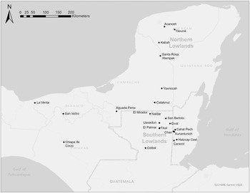
While E Groups are present in the northern lowlands (with recent examples revealed through LiDAR; e.g., Ringle et al. Reference Ringle, Negrón, Ciau, Seligson, Fernandez-Diaz and Zapata2021:26), comparatively few demonstrably originate in the Middle Formative. Stanton has documented the most likely known Middle and Late Formative examples in the western portion of the northern lowlands, citing Acanceh, Santa Rosa Xtampak, and Kabah (Stanton Reference Stanton, Freidel, Chase, Dowd and Murdock2017:454–460). As Yaxuná is the only extensively excavated northern lowlands E Group, it is the only one that researchers can usefully compare to the burgeoning record of early E Groups further south in the southern lowlands. Despite its location in the northern lowlands of Central Yucatan, the Yaxuná E Group complex's developmental sequence corresponds to emerging trends on the eastern Mesoamerican landscape, from roughly 1000 b.c. into the first centuries a.d. (Figure 1).
Map of eastern Mesoamerica, emphasizing the Maya lowlands, showing sites mentioned, including Yaxuná. Map by the author.

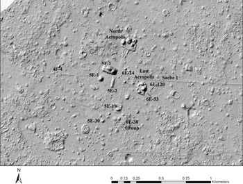
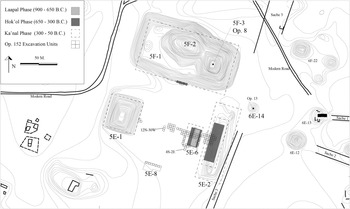
PIPCY extensively investigated the Yaxuná E Group for four field seasons, from 2013 through 2016 (Figure 2). The data presented here come from the investigation of 111 units, 2 m by 2 m, in the E Group, 29 of which reached bedrock (Figure 3). Excavations by PIPCY focused on the E Group Plaza (11 secure floor phases), Str. 5E-6 the original eastern structure (eight construction phases), and Str. 5E-2 the second eastern structure (three construction phases). These data are supplemented by PIPCY's investigations of the architectural groups 5E-19 and 6E-30 (Collins Reference Collins2018) and those carried out on Str. 6E-53 and Str. 6E-120 by the Selz Foundation Project, directed by David Freidel, Traci Ardren, and Charles Suhler between 1986 and 1996 (Ardren et al. Reference Ardren, Suhler, Freidel, Bennet and Johnstone1993; Stanton and Ardren Reference Stanton and Ardren2005; Stanton et al. Reference Stanton, Freidel, Suhler, Ardren, Ambrosino, Shaw and Bennet2010). The following account will chronologically span the four significant construction phases in the E Group, from its Middle Formative founding through the cessation of monumental construction, likely in the Terminal Formative (ca. 900 b.c. to a.d. 250).
LiDAR Hillshade map of Yaxuná, with buildings relevant to this study labeled. Map by the author; LiDAR data courtesy of Travis W. Stanton.

Topographic map of the Yaxuná E Group Plaza showing excavation units (represented by small gridded squares), highlighting Laapal and Hok'ol phase architecture. Map by the author.

The Laapal Phase (ca. 1000–650 b.c.)
As with other Middle Formative E Groups (e.g., Doyle Reference Doyle2013; Inomata Reference Inomata, Freidel, Chase, Dowd and Murdock2017b; Inomata et al. Reference Inomata, MacLellan, Triadan, Munson, Burham, Aoyama, Nasu, Pinón and Yonenobu2015; Reese-Taylor Reference Reese-Taylor, Freidel, Chase, Dowd and Murdock2017), the earliest construction in the Yaxuná E Group involved the meticulous scraping away of ancient humus layers and exposing natural bedrock. Stanton and colleagues (Reference Stanton, Dzul Góngora, Collins, Slater and Walker2021) have recently designated the ceramics associated with the clearing of bedrock as the Laapal Complex, which coincides with the pre-Mamom ceramics in the southern lowlands. The Laapal Complex has two facets: the Early Laapal (presumably earlier than 900 b.c.) and the Late Laapal (900–650 b.c.), which share burnished and wash surface treatments. However, the first true slips and specific surface colors (e.g., Almeja Burnished Gray) appear by the Late Laapal (Stanton et al. 2021).
Laapal Complex ceramics are spatially restricted to the E Group and observed nowhere else at Yaxuná. The Early Laapal is solely evidenced in a sealed and well-stratified midden in a natural aperture in bedrock just south of Str. 5E-6 excavated in unit 4S-2E. There were four ceramic types in the bottom two stratigraphic layers of unit 4S-2E: Huchim Burnished Rosy, Chel Burnished Buff, Kanxoc Unslipped, and Hunukú Brown Burnished Wash (Stanton et al. 2021). The hollow in unit 4S-2E had only pre-Mamom materials, and investigators did not encounter distinctly northern lowland Early Nabanche ceramics—similar to southern lowland Mamom materials. While conjectural, the presence of Early Laapal ceramics in a single midden may evidence the intentional clearing of an earlier occupation in the E Group's vicinity.
On the other hand, ceramics from the Late Laapal are more widely present, but remain restricted to the earliest three floors of the E Group (floors eleven, ten, and nine) between Str. 5E-1 and Str. 5E-6. Late Laapal ceramics are a mix of pre-Mamom and Mamom, consisting of the general ceramic groups of Joventud, Kin, Chel, Kanxoc, Hunuku, Huchim, and Dzeal. Stanton and colleagues (2021) believe that the earliest three floors (eleven, ten, and nine) associated with nine 14C dates between ca. 900 and 650 b.c. (Table 2) represent a transition between the pre-Mamom spheres of the Early Laapal complex and the subsequent Mamom spheres of the Hok'ol complex.
Ceramic chronology of Yaxuná, courtesy of Travis W. Stanton.

Calibrated 14C dates obtained from operation Yax 152 in the E Group Plaza.

Floors eleven, ten, and nine terminate at Str. 5E-6, the first eastern boundary of the plaza. To the west, these floors continue underneath the latest constructions of Str. 5E-1. Though untested, it seems plausible that an early form of Str. 5E-1 functioned as the first western boundary of the plaza. If accurate, then the original east–west axis of the plaza spanned roughly 60 meters.
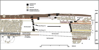
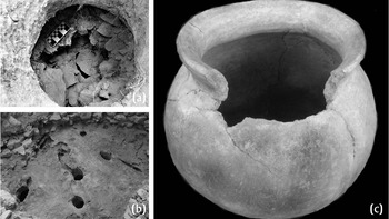
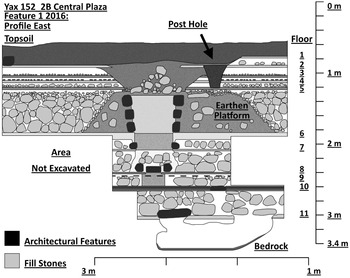
Investigations revealed that the earliest phase (Phase G) of Str. 5E-6, the first eastern boundary of the plaza, was a modified outcrop of bedrock rising 1 m above the plaza floor's surface (Figure 4). Excavations uncovered one of two foundational features marking the Yaxuná E Group on the exposed bedrock surface of Str. 5E-6, in the form of five observable open holes around the plaza's centerline, expanding into a possible cave system underneath (Figure 5). Four of the holes feature chipping, suggesting that they were intentionally made, with each being plugged and sealed by a limestone cap. Like the deposits placed in the modified bedrock foundations of several early E Groups (Doyle Reference Doyle2013:134; Estrada-Belli Reference Estrada-Belli2006:59; Inomata et al. Reference Inomata, MacLellan, Triadan, Munson, Burham, Aoyama, Nasu, Pinón and Yonenobu2015:4271), Stanton and colleagues (Reference Stanton, Taube, Collins, Freidel, Chase, Dowd and Murdock2022) argue that the Str. 5E-6 feature at Yaxuná also shares in this continuity and exhibits quadripartition.
South-facing profile showing a composite transect of Str. 5E-6. Drawing by the author.

Composite photos of the Str. 5E-6 bedrock foundation. (a) Close-up of a cut hole in bedrock containing an Ek Complex water jar, revealing a possible cave system; photograph by the author. (b) Image of the cut holes on the bedrock surface; photograph by the author. (c) Ek Complex water jar, after reconstruction. Photograph courtesy of Travis W. Stanton.

Placed within the central hole was a nearly complete short-necked ceramic jar with a burnished surface, which Stanton and colleagues (Reference Stanton, Collins, Love and Guernsey2021) believe represents early Ek Complex material, now thought to date between 1000 and 800 b.c. Significantly, a depression beside this hole drains directly into this central aperture, potentially granting insight into a function the holes and jar might have had for catching water. Water jars also characterized the cruciform feature, Cache Four in the Cival E Group (Estrada-Belli Reference Estrada-Belli2006:59). Curiously, the only other cultural object in this context was a single unrelated ceramic sherd.
The second foundational feature detected in the Yaxuná E Group was a natural aperture in bedrock exposed in unit 12N-30W, a space that seems to mark the plaza's original center. Like the constructed holes in bedrock on Str. 5E-6, the natural aperture in unit 12N-30W was also sealed by a large stone cap (Figure 6). Within the cavity were several ceramic fragments (likely from a single eroded vessel) and lithic tools composed of silicified limestone.
Stratigraphic profile of the unit 12N-30W, illustrating the central feature and intrusions in all 11 floor phases. Drawing by the author.

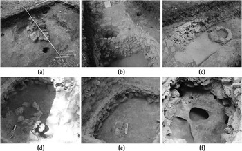
The feature in unit 12N-30W maintained long-term social significance and was repeatedly returned to, visibly marked, and reconstituted by intentional cuts on floors ten, eight, seven, six, and five. Unfortunately, erosion and burning characterized floor nine in this area, and investigators did not detect a feature. While evidence of at least two intentional cuts passing through floors four, three, and two obfuscate deposits on those levels, they did reveal additional episodes where this space was again returned to by later peoples at Yaxuná (Figure 7). Together, the evidence of activity in the plaza's original center revealed a presumably unbroken chain of continuity from its origin to its eventual disuse.
Breaks in floor phases of the Central Plaza Feature. (a) Termination ritual, showing three post holes around a circular cut breaking through floors one, two, three, and four, filled with marl, ash, and stone; (b) well-like feature constructed inside a small platform composed of earth and small stone rubble at the surface of floor five; (c) floor six with the bottom tear of the well-like feature and illustrating the pecked line boundary of the earthen rubble platform; (d) circular stones present on floor seven; (e) cut on floor eight sealed by a squared stone and lined with plaster; (f) natural aperture bedrock left accessible on floor 11, sealed with a stone, containing eroded ceramics from a single vessel and limestone lithic tools. Photographs by the author.

Outside of the E Group, there is no concrete evidence of permanent architecture at Yaxuná during this early period. Earthen floor constructions are the only known building traditions. Like the earthen floor constructions described at Ceibal (i.e., Inomata Reference Inomata2017a:346), the burning of floor nine might have been an attempt to increase durability. Potentially evidencing collective investment during the construction of the early tamped earth floors are the scatterings of ceramic and shell beads. Investigators documented similar-sized circular, triangular, rectangular, and star-shaped beads in every unit where the Laapal Phase floors (eleven, ten, and nine) were exposed and appear in no other contexts.
The Hok'ol Phase (650–300 b.c.)
During the second half of the Middle Formative, the first widespread changes to the Yaxuná settlement are visible, suggestive of village life (Stanton and Collins Reference Stanton, Collins, Love and Guernsey2021). Five 14C dates from floor eight during this period fall between ca. 750 and 400 b.c., closely coinciding with Hok'ol Complex ceramics (Stanton et al. Reference Stanton, Collins, Love and Guernsey2021). The Hok'ol Complex coincides with the Early Nabanche Complex of the northern lowlands site of Komchen, showing overlap with Mamom spheres of the southern lowlands (Stanton et al. Reference Stanton, Collins, Love and Guernsey2021). Vessel forms during the Hok'ol are similar to the Late Laapal, including short-necked jars and large, everted, flat-bottom bowls (Collins Reference Collins2018:128). However, everted flat-bottom bowls and (while rare) spouted vessels appear with increasing frequency.
With the construction of floor eight in the E Group, architectural traditions likewise change at Yaxuná. With the construction of floor eight, builders raised the plaza to the height of Str. 5E-6, Phase G, and constructed a small 30 cm rubble platform directly over the modified bedrock surface. Though the ancient peoples of Yaxuná might have lost the memory of the bedrock outcrop, its functions, and its association to a potential cave, subsequent constructions suggest that Str. 5E-6 remained significant.
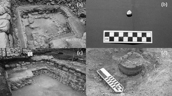
Just west of Str. 5E-6 on floor eight was a small round or apsidal stone foundation, roughly 2 meters in diameter, enclosed within a more extensive rectangular foundation spanning units 12N-4W and 12N-6W (Figure 8a). Round or apsidal foundations are commonly found among the earliest building forms in eastern Mesoamerica and typically predate more rectangular foundations for houses and other building forms (Aimers et al. Reference Aimers, Powis and Awe2000; Hammond et al. Reference Hammond, Gerhardt, Donaghey, Kosakowsky, Pring and Hammond1991). While this feature's presence was short-lived, ancient builders marked the space on several subsequent activities. Features on floor seven included concentrated burning and two sealed caches cut into the floor, one with a fragment of polished magnetite (Figure 8b). Floor six was marked by a 2 m diameter incised circle (Figure 8c), and floor five by a 2 m white circle of sascab. Finally, investigators uncovered a complete redware vessel with two greenstone beads cached on floor four (Figure 8d).
(a) Circular building present on floor eight, just west of Str. 5E-6; (b) fragment of polished magnetite found alongside other artifacts cached in a pair of intentional cuts on floor seven; (c) circular incised line present on floor six; (d) complete ceramic redware vessel cached in floor four associated with two greenstone beads. Photographs by the author.

Researchers encountered several blackened areas of concentrated burning on the exposed floor seven surface, directly above the apsidal stone foundation. The pattern of a floor becoming darkened by concentrated burning corresponds well with ethnographic observations of commemorations in domestic contexts. As Redfield (Reference Redfield1934:58), Redfield and Villa Rojas (Reference Redfield and Rojas1934:146), and Vogt (Reference Vogt and Mock1998:23) describe, candles and incense are burned in association with other ritual activities (the sacrifice of a chicken with feasting and alcohol) to commemorate the construction of a new household. While these ethnographers made observations in the early twentieth century, Inomata and colleagues (Reference Inomata, Triadan, Golden, Houston and Skidmore2015) argue that many domestic rituals in later sedentary households likely have their origins in rituals that first occurred in public spaces. As such, it seems plausible that the acts evidenced here may have commemorated the new construction while maintaining continuity with the actions and events experienced in an earlier era.
In the same area as the concentrated burning episodes of units 12N-4W and 12N-6W, two intentional cuts into floor seven, plugged with rectangular stone lids, were found containing large quantities of carbon, presumably organic materials, a single large rim sherd, and a single fragment of polished magnetite. Because the rectangular cuts overlap with the floor seven areas discolored by burning, this event likely happened later in time.
The small fragment of polished magnetite, a form of iron ore, was broken from a larger unknown object. Polished magnetite is not local to the Yucatan and tends to be associated with early use in the Gulf Coast while likely originating in Oaxaca (Flannery Reference Flannery and Benson1968:196; Flannery and Winter Reference Flannery, Winter and Flannery1976:40). Pires-Ferreira (Reference Pires-Ferreira and Flannery1976:324) has documented deposits of fragments and whole objects in ceremonial contexts throughout Gulf Coast sites between 1000 and 800 b.c.
After the laying of floor seven, Str. 5E-6 becomes visibly monumental with Phase F. The builders of Str. 5E-6, Phase F, used masonry stones of varying shapes and sizes, raising the building to a height of 2 m over the plaza floor surface. In contrast, smaller stones served as wedges between visible gaps to strengthen the building's integrity.
As with the changes in masonry techniques, so too there was a shift in plaza floor construction. Unlike the earlier floors of earth and clay, floors eight, seven, and six were composed of blended earth and pulverized sascab. The construction of floor seven saw the second-largest expansion of the E Group plaza, extending to 80 m east–west and at least 100 m north–south.
As with Ceibal, the expansion of the Yaxuná E Group to the east also coincided with the construction of a second and expanded eastern boundary (Inomata et al. Reference Inomata, MacLellan, Triadan, Munson, Burham, Aoyama, Nasu, Pinón and Yonenobu2015:4270). Str. 5E-2, the second eastern structure, established the new eastern boundary of the E Group, standing at least 4 m above floor seven of the plaza in its earliest phase. Like other early E Groups, the earliest phase of Str. 5E-2 was rectangular and did not appear to have had superstructures. Str. 5E-2, like Str. 5E-6, Phase F-2, was constructed with new cut masonry techniques, strengthened by wedges. With the construction of floor six, the ancient peoples of Yaxuná paused construction and maintained the building phases.
The Early Ka'nal Phase (400–200 b.c.)
During the transition to the Late Formative period, the community of Yaxuná extensively remodeled the E Group. Nine 14C dates associated with floors five and four consistently date between ca. 400 and 200 b.c. With Ka'nal Complex ceramics, there are minor changes. There are fewer everted lips and an increasing variety of vessel shapes. Jars and sizeable flat-bottom bowls remain abundant, though they become more restricted to un-slipped ceramic groups, such as Sabán, Achiotes, and Chancenote. More telling changes come with the appearance of basins and “buckets.” Stanton and colleagues (Reference Stanton, Collins, Love and Guernsey2021) argue that these shapes represent a set of activities, such as storage and fermentation, which hints at higher levels of permanence at places on the landscape.
By the Ka'nal Phase, Str. 5E-1, Str. 5E-2, and Str. 5F-1 achieved colossal proportions, rising above the tree line and creating a visible impact on the otherwise flat landscape. Builders modified and expanded Str. 5E-2 to a height of 7 m. Investigators uncovered two cornered walls on the west portion of Str. 5E-2 extending westward, revealing a squared central portion of the building suggestive of the Cenote style eastern structure (cf. Chase Reference Chase1983; Chase and Chase Reference Chase, Chase and Grube1995, Reference Chase, Chase, Freidel, Chase, Dowd and Murdock2017). Str. 5E-1 likely reaches near its maximum height of 14 m, while Str. 5F-1, too, reaches upwards of its maximum 26 m (Stanton et al. Reference Stanton, Freidel, Suhler, Ardren, Ambrosino, Shaw and Bennet2010:258). In addition, builders raised the height of the entire plaza floor by an impressive 60 cm.
Maintaining the planning of the plaza's new phase was the presence of several well-preserved incised line features, cutting as deep as 2 cm into floor six. The incised lines included a 2 m outlined cross, a rectangular series of lines spanning 60 m between Str. 5E-1 and Str. 5E-6, a 2 m diameter circle, and a pecked square marking a temporary earthen platform's boundary. Examining these distinct features will demonstrate continuity in the memory of previous activities and represent the incorporation of new traditions associated with the substantial constructions coinciding with floor five (Stanton and Collins Reference Stanton, Collins, Love and Guernsey2021).
First, builders pecked a square roughly 2 × 2 meters onto the floor six surface in unit 12N-30W. The pecked square's center was an opening 60 cm in diameter, representing continuity with the original plaza's central feature. Next, three tiers of stones were stacked to a height of 65 cm around the circular opening, creating a well-like feature that would have been visible on the surface of floor five. Finally, builders reinforced this feature with earth and cobbles within the pecked 2 × 2 m square. The result was a 2 × 2 m mound with a circular hollow in its center. In effect, this central mound, in alignment with Str. 5E-6, established a temporary E Group within the more extensive E Group bounded by Str. 5E-1 and Str. 5E-2.
An incised circle 2 m in diameter was present west of Str. 5E-6 in unit 12N-4W. It marked the very space where the apsidal room on floor eight once stood and where the two subsequent caching episodes took place on floor seven. Outside of physically marking a space of continued remembrance in the plaza, investigations revealed no other function for the incised circle.
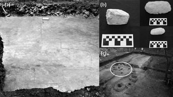
Differing from the features marking continuity was an incised cross spanning 2 m from end to end. Present in units 12N-20W and 12N-22W, it marked the new center of the expanded plaza, directly between Str. 5E-1 to the west and Str. 5E-2 to the east. Excavation revealed no caching episodes or clear evidence of activities before floor six near this space (Figure 9).
(a) Incised cross and rectangular lines present on floor six in the E Group plaza; (b) limestone axes present in the limestone fill around the incised cross; (c) causeway (chaak-be) present on floor five, highlighting five post holes (a possible altar) in the area directly over the incised cross. Photographs by the author.

Many Middle Formative E Groups in eastern Mesoamerica share in quadripartite symbolism, with carved crosses and paired axes spanning their central east–west axis—a tradition observed between 1000 and 300 b.c. (Aoyama et al. Reference Aoyama, Inomata, Pinzón and Palomo2017; Estrada-Belli Reference Estrada-Belli2006:59; Inomata Reference Inomata, Freidel, Chase, Dowd and Murdock2017b:223–226; Inomata and Triadan Reference Inomata, Triadan, Golden, Houston and Skidmore2015). Like the quadripartite plaza offerings in other E Groups, the Yaxuná cross-feature was associated with axes, though of varying limestone quality, recovered in the fill directly on and around the incised cross. In association were two chert flakes worked into rough teardrop forms. These flakes showed no signs of use-wear, suggesting they were prepared and then deposited. Furthermore, investigators recovered an additional teardrop-shaped object of greenish grey material, possibly volcanic pumice, of comparable size to the chert objects in this context. As an object class, axes, celts, or similar categories of pseudo-celts, were only found within the E Group in fill contexts underneath floor five.
A final series of incised lines spanning 6 m east–west were exposed in units 14N-24W, 14N-22W, and 14N-20W. These lines were organized in squares, with nearly equal sides measuring between 164 and 168 cm. Small cobble fill of limestone was packed together in the space between the northern and southern lines spanning east–west. In contrast, outside of the northern and southern incised lines, large stone fill was laid, creating a visible difference.
Built directly over the packed small stone fill was a narrow sascab causeway (sacbe, meaning “white road” in Yukatec Maya) present on floor five. This causeway, dubbed the chaak-be (or “red road” because of its distinctly rose hue), stood 20 cm above floor five. Excavations in unit 14N-60W encountered the chaak-be at Str. 5E-1. Its eastern terminus was located on Str. 5E-6 in unit 14N-0W, spanning 60 m in length, averaging 160 cm in width across the plaza. The chaak-be was encountered in 12 units and detected by ground-penetrating radar. While only wide enough for a sole person, the chaak-be was an important feature that likely functioned as a stage for political and religious processions linked to the emerging authorities of Yaxuná. The possibility of rulership at Yaxuná during this period will be expanded in the discussion below.
The Late Ka'nal and Ahal Phases (200 b.c. to a.d. 250)
After raising the E Group plaza with floor five, modifications to the E Group slow and eventually halt. The combined raised height of the plaza after floor five's construction (including the four remaining floors) measured roughly 40 centimeters. Sometime during this period, Str. 5E-2 undergoes a final modification, transforming into a broad rectangular platform with at least three superstructures—highly reminiscent of the Uaxactun Style E Group (Chase and Chase Reference Chase, Chase and Grube1995, Reference Chase, Chase, Freidel, Chase, Dowd and Murdock2017). Later, in the Classic period, Str. 5E-2 will be robbed of stone and partially dismantled (Stanton et al. Reference Stanton, Freidel, Suhler, Ardren, Ambrosino, Shaw and Bennet2010). However, the earliest feature in sequence to be effectively erased from the E Group was the chaak-be, the narrow causeway present on floor five. Because of its planning and symbolism, it is somewhat perplexing that the chaak-be would be entirely covered by floor four's construction and effectively forgotten. With the erasure of the chaak-be, the central civic-ceremonial focus of the E Group, too, begins to wane, and the axial orientation begins to shift at Yaxuná.
Stanton and Ardren (Reference Stanton and Ardren2005:217) reported that the Middle Formative at Yaxuná witnesses the construction of the north-facing monumental pyramid, Str. 5E-19, in the southern sector of the site. The construction of Str. 5E-19 signals the establishment of a north–south axis by Str. 5E-19, accentuated by a sacbe emanating from this building (Stanton Reference Stanton2000:321). South of Str. 5E-19, the north-facing 6E-30 group is the largest Middle Formative residential group at Yaxuná, dominated by a pyramidal structure on the south of the group. The initial constructions of the Str. 5E-19 and the 6E-30 group show that Yaxuná had a north–south and an east–west axis during the emergent period of the Middle Formative.
Late Ka'nal ceramics found in the North Acropolis, East Acropolis, 5E-19, and 6E-30 groups (all of which are Triadic Acropolis Groups) show that the quadripartite axis was maintained into the Late Formative. Excavations of the North Acropolis, East Acropolis, 5E-19, and 6E-30 revealed Ka'nal and Ahal Complex ceramics, suggesting that their construction postdates the E Group (Stanton Reference Stanton, Freidel, Chase, Dowd and Murdock2017:464). These building efforts shift the axis of Yaxuná outside of the E Group, linking the predominant Triadic Acropolis Groups to a new site core by way of new Late Formative roads or sacbeob (Stanton and Freidel Reference Stanton and Freidel2005).
Like Cival, albeit with Triadic Acropolis Groups instead of E Groups (Estrada-Belli Reference Estrada-Belli, Freidel, Chase, Dowd and Murdock2017:307), the layout of Yaxuná takes on a cruciform arrangement, with the E Group oriented slightly to the west of the site's core (Stanton et al. Reference Stanton, Freidel, Suhler, Ardren, Ambrosino, Shaw and Bennet2010:85–86). Extending from this principle, Stanton and Freidel (Reference Stanton and Freidel2005:226) make the case that the principal Late Formative civic architecture in the core of Yaxuná was built as a geomantic plan, or cosmogram, creating a sacred space linking myth, religion, and ruler. They argue that the quadripartite organization enhanced rulers’ legitimacy while linking them to the site's sacred landscape (Stanton and Freidel Reference Stanton and Freidel2005:241).
At the center of the Yaxuná cosmogram on Sacbe 3 is the small radial platform Str. 6E-14. The construction of Str. 6E-14 re-established the center of the site's now quadripartite axis outside of the E Group, serving as a nexus between the site's monumental Triadic Acropolis Groups—the North Acropolis (to the north), the East Acropolis (to the east), and the 5E-19 and 6E-30 groups (to the south). The significance of Str. 6E-14, as a result, should not go unrecognized, as it marks a critical social and political shift at Yaxuná away from the E Group (Stanton and Freidel Reference Stanton and Freidel2005). In addition, dry core fill from the interior of Str. 6E-14 contained Ka'nal and Tepalil Complex ceramics, suggesting a Terminal Formative or Early Classic date for construction—one of the only buildings known to date to this period at Yaxuná (Stanton et al. Reference Stanton, Freidel, Suhler, Ardren, Ambrosino, Shaw and Bennet2010:86).
Regarding the shift away from the E Group at Yaxuná, it is worth considering Str. 5F-1, the largest single construction at the site (Stanton et al. Reference Stanton, Freidel, Suhler, Ardren, Ambrosino, Shaw and Bennet2010:82). While roughly three times the size of the Castillo at Chichen Itza, there is almost no information on the interior sequence of this two-peaked monumental construction. One can infer that Str. 5F-1 was likely originally designed as a symmetrical acropolis. While speculative, the construction of Str. 5F-1's second peak, an eastern-end pyramid, suggests a reorientation dating to the Late Formative period, further emphasizing a shift away from the E Group as the site's center. In any case, Str. 5F-1 signals a significant amplification of power in the mobilizing of labor and overshadows the E Group.
While some monumental buildings were maintained and expanded upon in the latter portion of the Late Formative, construction considerably waned at Yaxuná by 50 b.c. After this point, construction efforts are almost exclusive to the north–south axis at Yaxuná, which eventually dominates the Classic period of the site, with ongoing constructions on the North Acropolis. Some of the final modifications detected by investigators in the E Group were the deposition of stone spheres and the intentional destruction of some features, interpreted as termination rituals. Termination ritual refers to actions that bring about the end of a life cycle to a physical feature (like a cave, house, or temple) analogous to a human life cycle (Boteler Mock Reference Boteler Mock and Mock1998:9). For the peoples of Mesoamerica, termination rituals could represent the renewal of indestructible essence (Vogt Reference Vogt and Mock1998:27), ritual cleansing, or acts to bring about the end of a feature's ensoulment (Stross Reference Stross and Mock1998:37). Such acts effectively brought to a close longstanding traditions marked mostly by continuity (Freidel et al. Reference Freidel, Suhler, Palma and Mock1998:140–142).
First, excavators encountered the deposition of several stone spheres in the E Group associated with the final phase of Str. 5E-6. In total, excavators recovered 109 stone spheres, with diameters averaging around 9 centimeters. Often the stone spheres were found clustered in groups of ten or more, in place of masonry stones on the outer perimeter of the structure. Because of their association to the final phase of Str. 5E-6, excavators proposed a connection between the stone spheres and termination rituals (Collins Reference Collins2018:803).
Researchers recovered similar caches of stone spheres from Late Formative contexts in the Ceibal E Group. Thus, while recognizing their rarity in the Maya lowlands, Inomata (Reference Inomata, Freidel, Chase, Dowd and Murdock2017b:231) suggests a possible connection between stone spheres and calendric rituals in the Guatemala highlands, southern Pacific Coast, and central Chiapas. If the same is true at Yaxuná, then the presence of stone spheres might suggest sustained continuity and association with southern lowland centers such as Ceibal, and a connection with Isthmian region E Groups.
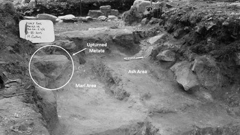
In addition to the stone spheres, investigators recognized another termination ritual on Str. 5E-6 (Figure 10). In units 12N-0E, 12N-2E, and 14N-2E, the uppermost floors were visibly broken. Incised lines present in 12N-0E, near the broken floor edges, suggested that some degree of forethought went into this intrusion. Within the created aperture were large loose stones coated in cleaned ash. Finally, a metate in unit 14N-2E was upturned in this area before being covered in 30 cm of marl. Eventually, Str. 5E-6 was lightly coated with the earth, as observed with other terminations at Yaxuná (Freidel et al. Reference Freidel, Suhler, Palma and Mock1998:142).
Termination ritual present on Str. 5E-6, highlighting an upturned metate, marl, and ash areas. Photograph by the author.

A final feature in unit 12N-30W that investigators interpret as a termination ritual marked continuity with a foundational event in a cavity of bedrock during the Lapaal Phase. The termination in unit 12N-30W entailed breaking the final plaza floor (floor one) and digging through portions of floors two, three, and four. Next, loose stones were piled in the center of this area, nearly 2 meters in diameter, including 13 stone spheres. Cleaned ash was then poured over the stones, and the feature was covered in earth.
DISCUSSION
The broad distribution of E Groups in eastern Mesoamerica, their longevity, and distinct developmental histories suggest that selective forms of maintaining continuity (memory) and seeking disjuncture (forgetting) are present at most, if not all, with origins in the Middle Formative. Inomata (Reference Inomata, Freidel, Chase, Dowd and Murdock2017b:232) notes that E Groups’ symbolic values and social roles most likely changed through time as diverse groups adopted them and reworked them. In the Middle Formative, the Maya lowlands selectively adopted the E Group from the MFC pattern of the Gulf Coast, Pacific Coast, and Chiapas variety—maintaining continuity by including the foundational practices of scraping away earlier humus layers, concealing previous occupations, modifying bedrock, and making foundational deposits (Inomata Reference Inomata, Freidel, Chase, Dowd and Murdock2017b:220). However, Maya E Groups largely abandoned other aspects of MFC pattern architecture and depositing greenstone in plazas (Inomata Reference Inomata, Freidel, Chase, Dowd and Murdock2017b:228). By the Late Formative transition, lowland E Groups took on colossal proportions and link to emergent rulership. However, modifications become increasingly context-dependent with regional variation.
Yaxuná's E Group, too, shares many of the symbolic values and social roles of other excavated examples, selectively incorporating attributes found at E Groups throughout its occupational history. Many familiar elements of Middle Formative E Groups shared throughout eastern Mesoamerica are present with the founding of Yaxuná, including quadripartite commemorations, modifications of bedrock, and use of earthen or bedrock platforms as early incarnations of the eastern structure. In contrast with the southern lowland site of Ceibal, the founding of Yaxuná's E Group appears to conform more to the Maya lowlands variety of early E Groups, as researchers did not detect deposits of greenstone axes in the plaza (Inomata Reference Inomata, Freidel, Chase, Dowd and Murdock2017b:220–223).
However, Yaxuná's founding between 900 and 800 b.c. is suggestive as one of the earliest E Groups in the Maya lowlands. Daniella Triadan (personal communication 2017) has suggested that an MFC pattern could be present at Yaxuná, though the possibility remains untested. Likewise, no excavations have taken place on Str. 5E-1, the western E Group pyramid at Yaxuná. As the earliest floors, eleven, ten, and nine, do continue underneath Str. 5E-1, the data from the presumed early western boundary of the E Group could be revealing. Moreover, researchers have recovered Olmec-style caches of greenstone dating to 900 b.c. in the northern lowlands in an early residential plaza at the site of Paso del Macho (Parker et al. Reference Parker, Bey and Negrón2020). These axes bear a striking resemblance with similar greenstone objects recovered near the town of Chacsinkin (Andrews Reference Andrews, Wyllys, Wyllys and Andrews1986:11), south of Yaxuná on the trade route proposed by Stanton (Stanton Reference Stanton, Freidel, Chase, Dowd and Murdock2017:450) linking the northern lowlands to the central peninsular region and southern lowlands. While investigators did not recover greenstone from the Yaxuná E Group in its earliest phase, the cached fragment of magnetite suggests that a possible connection with Olmec centers, minimally by way of trade, is not out of the question.
Even so, the selective incorporation of distinct attributes in E Groups may have been a necessary form of maintaining connections and identity linked with distant spaces. Though even at Ceibal, Inomata suggests that while MFC architecture remained, its original purpose was largely lost by the Late Formative, signifying a transformation of the E Group that “implied a connection to the distant past rather than a reference to distant places” (Inomata Reference Inomata, Freidel, Chase, Dowd and Murdock2017b:229). As with the early E Groups in the Maya lowlands, selective disjuncture might have helped forge new identities, serving as the bedrock for those communities to begin a somewhat new memory narrative (cf. Connerton Reference Connerton2009). Despite similarities, there is little evidence of hegemonic imposition in Middle Formative Maya lowland E Groups. Notably, they all trend towards growing elites and rulership by the Late Formative (Brown Reference Brown, Freidel, Chase, Dowd and Murdock2017:406; Doyle Reference Doyle, Freidel, Chase, Dowd and Murdock2017a; Ebert et al. Reference Ebert, McGee and Awe2021; Estrada-Belli Reference Estrada-Belli2006; Inomata Reference Inomata, Freidel, Chase, Dowd and Murdock2017b:241; Saturno et al. Reference Saturno, Beltran, Rossi, Freidel, Chase, Dowd and Murdock2017).
Early writing from San Bartolo suggests that the institution of divine rulership was present between 300 and 200 b.c. (Saturno et al. Reference Saturno, Taube and Stuart2005)—coinciding with the monumental construction episodes in E Groups at the onset of the Late Formative. Currently, researchers have proposed direct connections between rulership at E Groups around 300 b.c. at sites such as Tikal and El Palmar (Doyle Reference Doyle, Freidel, Chase, Dowd and Murdock2017a:280), San Bartolo (Saturno et al. Reference Saturno, Beltran, Rossi, Freidel, Chase, Dowd and Murdock2017:350), Cival (Estrada-Belli Reference Estrada-Belli2006:59, Reference Estrada-Belli2011:64), and Cahal Pech (Ebert et al. Reference Ebert, McGee and Awe2021:215–216). Indeed, Freidel and Suhler (Reference Freidel, Suhler and Kowalski1999:273) and Stanton and Freidel (Reference Stanton and Freidel2005:226) have made a case for emergent rulership at Yaxuná by the Late Formative, albeit from evidence outside the E Group.
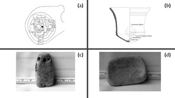
East of the Yaxuná E Group are Str. 6E-120 and Str. 6E-53—sometimes referred to as the Dance Platforms. Str. 6E-120 and Str. 6E-53 are small earthen mounds with hollow cruciform interiors representing symbolic caves (Stanton and Freidel Reference Stanton and Freidel2005; Suhler Reference Suhler1996). Hok'ol and Ka'nal ceramics, along with radiocarbon dates from samples within Str. 6E-120, suggest a probable construction date between 300 and 200 b.c. (Stanton Reference Stanton, Freidel, Chase, Dowd and Murdock2017:463–464; Travis W. Stanton, personal communication 2020). Presumably, a performer could emerge from the building, invoking later depictions of the Maize deity emerging from the animate earth's sacred interior (Freidel and Suhler Reference Freidel, Suhler and Kowalski1999:254). In the cruciform hollow of Str. 6E-53 was an offering containing two greenstone pendants (Figure 11), one fashioned in the shape of a celt and the other like that of a gouge (Freidel and Suhler Reference Freidel, Suhler and Kowalski1999:271; Stanton et al. Reference Stanton, Freidel, Suhler, Ardren, Ambrosino, Shaw and Bennet2010:146).
Str. 6E-53 of the dance platforms, showing the contents of Cache 5. (a) Plan drawing of Str. 6E-53; (b) profile of Cache 5, showing ceramic container with its contents; (c) greenstone celt pendant; (d) greenstone mirror or gouge pendant. Images courtesy of Travis W. Stanton.

Freidel and Suhler (Reference Freidel, Suhler and Kowalski1999:273) have suggested that the quadripartite symbolism and greenstone cache associated with Str. 6E-120 and Str. 6E-53 could be an indicator of early kingship at Yaxuná. Because Str. 6E-120 and Str. 6E-53 are contemporary with the monumental floor five construction phases of Str. 5E-1 and Str. 5E-2 and share symbolism (including the pairing of an incised cross with axes), a direct connection between emergent rulership and the E Group seems more plausible. On the relationship between rulership and monumental buildings, Freidel and Suhler (Reference Freidel, Suhler and Kowalski1999:273) state:
Maya buildings were designed not simply as static monuments to the power of their human patrons, but as places for the performance of transcendent events linking those rulers both to their human followers and their supernatural patrons.
Like Saturno et al.'s (Reference Saturno, Beltran, Rossi, Freidel, Chase, Dowd and Murdock2017:329) argument for San Bartolo's Sub-5 E Group, the linking of old symbols to new authorities at Yaxuná could indicate both continuity and subtle disjuncture with the site's past. As Gillespie (Reference Gillespie2010:408) reminds us, the preservation (or continuity) of memory in durable media is also an interpretation or manipulation of the experienced past within a present moment—marking disjuncture. The presence of symbolic caves during the fourth century b.c. is a materialization of symbolism already related to the E Group. In linking themselves to the symbols of the past, rulers would also invoke the social memories attached to the founding of distant E Groups. Such symbols might also signify connections to centers in the Gulf Coast, Pacific Coast, or Chiapas, where plaza axe caching remained active, as with Chiapa de Corzo (Bachand et al. Reference Bachand, Lowe, Murrieta, Mejía and Laporte2009).
If we accept the possibility of emergent rulership at Yaxuná during the Late Formative transition, as evidenced by the E Group, Str. 6E-120, and Str. 6E-53, then it is vital to recognize that the emergence of the subsequent Triadic Acropolis Groups connects to broader trends in the Maya lowlands. Coinciding with the emergence of rulership, many Late Formative Maya communities undergo planned recentering episodes (Doyle Reference Doyle2017b:71). Some E Groups remain central with planned monumental expansion, as with the centering of Cival's principle E Group within a broader quadripartite axis of E Groups (Estrada-Belli Reference Estrada-Belli, Freidel, Chase, Dowd and Murdock2017:318). However, at other sites, attention shifts away from E Groups to new forms of monumental architecture, such as Triadic Acropolis Groups throughout the lowlands (Doyle Reference Doyle2017b:71) or Eastern Triadic Assemblages in the Belize River Valley (cf. Ebert et al. Reference Ebert, McGee and Awe2021:210).
Like San Bartolo, the phase of the Yaxuná E Group associated with emergent authorities was relatively short-lived, and Triadic Acropolis Groups and Str. 5F-1 become the focus of new monumental construction (cf. Saturno et al. Reference Saturno, Beltran, Rossi, Freidel, Chase, Dowd and Murdock2017:329). As noted above, Stanton and Freidel (Reference Stanton and Freidel2005:226) have argued that the principal Late Formative triadic architecture in the site core of Yaxuná was built as a geomantic plan, linking myth, religion, and ruler. Such a scenario gains additional weight when considering that excavations of the North Acropolis, a Triadic Acropolis, are associated with the burials of the earliest known rulers at Yaxuná (Stanton et al. Reference Stanton, Freidel, Suhler, Ardren, Ambrosino, Shaw and Bennet2010:262). Investigators encountered a similar pattern at Tikal, where the earliest rulers’ burials were uncovered in the site's prominent Triadic Acropolis, the North Acropolis (Doyle Reference Doyle, Freidel, Chase, Dowd and Murdock2017a:280; Laporte and Fialko Reference Laporte and Fialko1995:49).
While the Yaxuná E Group is not concealed or dismantled (at least not during the Late Formative), the growth of the Triadic Acropolis Groups overshadows it. Just as Saturno et al. (Reference Saturno, Beltran, Rossi, Freidel, Chase, Dowd and Murdock2017:333) argue for San Bartolo, it is plausible to suggest that an authority at Yaxuná, perhaps a ruler, also sought to distance themselves from the spaces of a previous lord. After all, Str. 6E-120 and Str. 6E-53 are filled in and overshadowed by the East Acropolis's construction.
While E Groups are among the first and most prominent monumental complexes in the Maya lowlands, they are also among the first associated with rulership. However, as noted in the examples above, not all E Groups maintain a connection to rulership. Once rulership is in place during the transition to the Late Formative, the modification of E Groups by way of continuity, reconstitution, and abandonment begin to mirror the selective treatment of monumental groups by later Classic Maya authorities (cf. Ashmore Reference Ashmore2015; Child and Golden Reference Child, Golden, Stanton and Magnoni2008; Gillespie Reference Gillespie2010; Houston et al. Reference Houston, Escobedo, Child, Golden, Munoz and Smith2003; Marken Reference Marken and Marken2007; Schwake and Iannone Reference Schwake and Iannone2010). The question then becomes, why are some E Groups remembered and others forgotten?
Although it is speculative, one potential explanation could be that emergent Late Formative rulers would have to contend with the social memory of different political institutions and possibly that of a less stratified past. In this way, as Inomata (Reference Inomata, Freidel, Chase, Dowd and Murdock2017b:241) suggests, continuity (and quite possibly disjuncture) with monumental Late Formative E Groups could more strongly represent ties to a distant and imagined past—one “claimed, embraced, and tolerated by diverse groups, including growing elites, ritual specialists, and commoners.” We might also consider that emergent rulers were agents in directing the expression of local memory narratives through subtle and overt measures. How emergent rulers attempted to expand, modify, diminish, or even erase E Groups may also reflect expressions of their respective authority and that of trends in regional styles.
At San Bartolo, for example, the E Group existed for three major iterations before becoming linked to rulership. It was only the final phase of the E Group, Sub-5 or Ixbalamque, where the connection with rulership was clear. A later ruler transformed Sub-5 into a Triadic Acropolis, concealing the E Group and visible associations to a previous ruler's authority (Saturno et al. Reference Saturno, Beltran, Rossi, Freidel, Chase, Dowd and Murdock2017:333). Whether it was in a ruler's best interest to maintain an E Group or adopt a new form of monumental complex, there does appear to be a trend to shift the focus away from E Groups relatively soon after the institution of rulership is present.
Modifications to E Groups by Late Formative rulers parallel efforts by later Classic period lords. The texts commissioned by Classic Maya lords often positioned the ruler at the center of massive timelines that reach into mythological eras, showcasing their respective authorities’ would-be totality in time and space (Houston Reference Houston2000:145). These same rulers commissioned massive campaigns to dramatically alter the built environment and past people's experience of it (e.g., Ashmore Reference Ashmore2015; Gillespie Reference Gillespie2010; Houston et al. Reference Houston, Escobedo, Child, Golden, Munoz and Smith2003; Marken Reference Marken and Marken2007; Schwake and Iannone Reference Schwake and Iannone2010). With the site of Quirigua, Ashmore (Reference Ashmore2015:226–227) has argued that acts of remembrance concerning past rulers were contingent upon recognizing distinct present political authorities by different groups. In this way, the memory and would-be totality of an individual ruler were actively contested. Who was to be remembered, how traditions were enacted, and the present political implications of such an active process shifted over time.
How Late Formative E Groups were remembered and forgotten likewise appears to have been actively contested. As Chase and Chase (Reference Chase, Chase, Freidel, Chase, Dowd and Murdock2017:65) recognize, the emergence of secular orders, as represented by dynastic rulers, purposefully conflated themselves with E Groups through durable media. However, they clarify that these “secular orders” never fully replace E Groups, as many southern lowlands examples, including Uaxactun, Caracol, Cenote, and Calakmul, continue to be maintained well into the Classic period (Chase and Chase Reference Chase, Chase, Freidel, Chase, Dowd and Murdock2017:65). However, many E Groups with origins in the Middle Formative were deemphasized at centers such as Tikal (Doyle Reference Doyle, Freidel, Chase, Dowd and Murdock2017a:282; Laporte and Fialko Reference Laporte and Fialko1995:49). Some examples of E Groups, and I suspect investigators will reveal more, were reconstituted as new monumental groups entirely (Saturno et al. Reference Saturno, Beltran, Rossi, Freidel, Chase, Dowd and Murdock2017:333; Ebert et al. Reference Ebert, McGee and Awe2021:215). Furthermore, many southern lowlands sites with E Groups, such as El Palmar, Cival, San Bartolo, and Nakbe, undergo at least partial abandonment before the Classic Period (Brown Reference Brown, Freidel, Chase, Dowd and Murdock2017:404; Doyle Reference Doyle2017b:114). If Stanton (Reference Stanton, Freidel, Chase, Dowd and Murdock2017:469) is correct, then a similar trend of abandonment likely played out with the few known Late Formative northern lowland E Groups.
With Yaxuná, the colossal constructions associated with floor five of the E Group may connect well with a ruler. But like many southern lowland centers in the following centuries, the emergence of rulership marks a deemphasis and general decline of the E Group as the central focus of a settlement. With the shifting of Yaxuná's axis, rulership becomes embodied in the new Triadic Acropolis Group. There is a marked disjuncture from the monumental space that once characterized the entirety of Yaxuná's Middle Formative period. Eventually, Str. 5E-2, one of the first monumental buildings associated with rulership, is robbed of stone (Stanton Reference Stanton, Freidel, Chase, Dowd and Murdock2017:469), and the features marking continuity with the origins of Yaxuná are selectively buried and forgotten.
CONCLUSION
Paramount to this discussion is that the selective role of memory (collective acts of remembrance and forgetting) relates to the data presented here as an active tool to negotiate meaning in monumental space through the experience of tradition. As such, selecting, emphasizing, and diminishing different collective memories would potentially be exploited by emergent authorities, increasingly looking to solidify developing hierarchical and stratified structures in the first millennium b.c. Yet the expression of remembering and forgetting here not only relates to local traditions and political contexts, but, to a certain extent, encapsulates an emergent shared character in the Maya lowlands.
After 1000 b.c., E Groups gradually became the somewhat standardized spaces of community-wide integration in the Maya lowlands. Through the collectively recognizable monumental form of an E Group, low-density communities like Yaxuná could honor local past experiences while still participating in regional trends. From a similar foundation, identities, ritual practices, and social relationships could become fixed in the experience of a place that also represents a collectively imagined space.
Extensive excavations in Yaxuná's E Group plaza revealed a long construction sequence in the first millennium b.c. Memory played a role in directing the peoples of Yaxuná in returning to significant spaces of their shared past, in near unbroken sequences, throughout the Middle Formative. The material fingerprints of such reoccurring activities in the plaza signal the great importance that the space must have held for the past peoples of Yaxuná for countless generations.
With increased stratification at Yaxuná by the Late Formative transition, there is a marked shift in the E Group's character, trending towards a greater incorporation of building practices, symbols, and elite control. These transformations coincide with the emergence of rulership in the southern lowlands (Estrada-Belli Reference Estrada-Belli2006, Reference Estrada-Belli2011, Reference Estrada-Belli, Freidel, Chase, Dowd and Murdock2017; Saturno et al. Reference Saturno, Beltran, Rossi, Freidel, Chase, Dowd and Murdock2017; Stanton Reference Stanton, Freidel, Chase, Dowd and Murdock2017). Initially, the emergence of rulership coincided with new phases of monumental construction in the E Group, further marking the spaces of continuity linking back to the founding of Yaxuná. After that, however, the importance of the E Group, and the memory of Yaxuná's founding, gradually waned. Subsequent authorities shifted the focus to Triadic Acropolis Groups and new roadways outside of the E Group, overshadowing the former community center until it was partially dismantled. As a result, its importance is largely forgotten.
RESUMEN
Al buscar continuidades y disyuntivas de los precedentes de autoridades pasadas, la clase dominante emergente durante el período formativo fueron agentes activos en la dirección de cambios al espacio monumental, lo que sugiere que la memoria jugó un papel vital en el desarrollo de un carácter temprano compartido de las formas de vida mayas (1000 a.C. a 250 d.C.). La tendencia es más visible en los complejos cívicos ceremoniales conocidos como Grupos E, que tienden a mostrar patrones significativos de continuidad (recordar) y disyunción (olvidar). Este artículo utiliza el sitio de las tierras bajas del norte de Yaxuná en Yucatán, México, para demostrar el uso de estrategias selectivas tempranas para dirigir la memoria colectiva. Si bien hay Grupos E en las tierras bajas mayas del norte, se conocen pocos ejemplos del período formativo, lo que convierte a Yaxuná en un caso de estudio crítico para la evaluación comparativa con las tierras bajas del sur. Una implicación de los datos de Yaxuná es que el patrón más amplio de los Grupos E del formativo medio resultó de una interacción social, religiosa, política y económica sostenida entre diversos grupos de pares en Mesoamérica oriental. Con el surgimiento del gobierno institucionalizado en las tierras bajas mayas durante el formativo tardío, las autoridades locales jugaron un papel significativo en la dirección de las transformaciones de los Grupos E, influyendo selectivamente en sus significados y trayectorias cada vez más independientes a través de la continuidad y la disyunción.
ACKNOWLEDGMENTS
I thank the Consejo de Arqueología of the Instituto Nacional de Antropología e Historia for granting the permits to conduct this research; all data are the cultural patrimony of Mexico. Special thanks to Proyecto de Interacción Política del Centro de Yucatán (PIPCY), directed by Travis W. Stanton, Traci Ardren, and Aline Magnoni, for your support and encouragement in this research. This research was generously supported by Mellon Foundation Dissertation Research Grants and the Jane's Research Grant from the Brandeis University Latin American and Latino Studies Program. Special thanks to the Department of Anthropology at Brandeis University, who in part funded this research, provided feedback and awarded an early version of this article the Robert A. Manners Prize. Thank you to the William H. Neukom Institute for Computational Science for supporting the creation of this article. Finally, I thank the community of Yaxunáh for allowing me to conduct research in their ejido and sharing knowledge of their heritage. I am privileged to be able to work in this community.