1. Introduction
The Zagros fold-and-thrust belt is the result of continental collision between the Arabian and Eurasian plates (Takin, Reference Takin1972; Berberian & King Reference Berberian and King1981; Koyi, Reference Koyi1988). The onset of convergence started with ophiolite obduction in Late Cretaceous time (Agard et al. Reference Agard, Omrani, Jolivet and Mouthereau2005) and continued with a main folding phase in Late Miocene time (Homke et al. Reference Homke, Verges, Miguel Garces, Emami and Karpuz2004).
The foredeep depression started to develop in the inner Zagros after deposition of the widespread Upper Oligocene platform carbonate (Lower Asmari Formation) (Sherkati, Letouzey & Frizon de Lamotte, Reference Sherkati, Letouzey and Frizon de Lamotte2006; van Buchem et al. Reference Van Buchem, Baghbani, Bullot, Caron, Gaumet, Hosseini, Immenhauser, Keyvani, Schroeder, Vedrenne and Vincent2006) and migrated southwestward down to its present position in the Persian Gulf.
The Late Oligocene–Early Miocene was the period of sedimentation of the light-coloured limestone of the Asmari Formation on the flanking shelves of the Zagros foredeep (Ziegler, Reference Zeigler2001). In this context, confining facies with evaporites and salt deposited in the Zagros domain by Early and Middle Miocene times, before the main folding event.
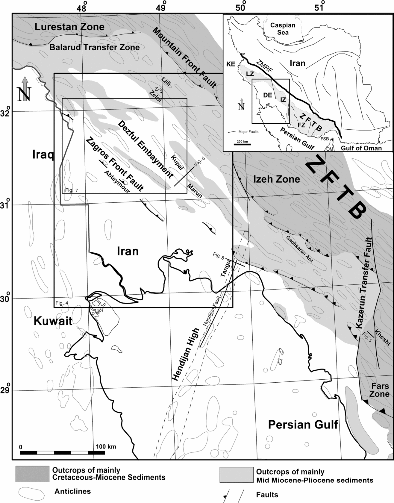
Three major Neogene evaporitic basins developed in the Iranian Zagros domain: the Early Miocene Kalhur evaporitic basin, now located in the southern part of Lurestan province (Motiei Reference Motiei1993; Ahmadhadi, Lacombe & Daniel, Reference Ahmadhadi, Lacombe, Daniel, Lacombe, Lavé, Vergés and Roure2007; Saura et al. Reference Saura, Verges, Homke, Blanc, Serra-Kiel, Bernaola, Casciello, Fernandez, Romaire, Casini, Embry, Sharp and Hunt2011); the Early–Middle Miocene Fars salt basin, now located in the south Persian Gulf; and the Mid Miocene Gachsaran Formation with anhydrite, marl, salt and limestone content (James & Wynd, Reference James and Wynd1965), not only deposited in the Dezful Embayment but also in the SW Lurestan region. In these provinces the Gachsaran Formation has been involved in the Zagros folding. It has a major role in sealing the Asmari carbonate reservoir in the Dezful Embayment (Fig. 1).
Simplified geological map of the Central Iranian Zagros modified from the National Iranian Oil Company geological map of SW Iran at scale 1:1000000. Abbreviations: KE – Kirkuk Embayment; LZ – Lurestan Zone; DE – Dezful Embayment; IZ – Izeh Zone; FZ – Fars Zone; FSB – Fars salt basin; OM – Oman Mountains; ZFTB – Zagros fold–thrust belt; ZMRF – Zagros Main Reverse Fault.

The Gachsaran Formation is the thickest and most widespread Neogene evaporitic unit. It acted as an intermediate decollement unit during evolution of the Zagros fold-and-thrust belt (Bahroudi & Koyi, Reference Bahroudi and Koyi2004; Sherkati, Letouzey & Frizon de Lamotte, Reference Sherkati, Letouzey and Frizon de Lamotte2006).
It has been suggested that a large proportion of Gachsaran salt was re-precipitated from Hormuz salt, extruded in diapirs east of the Kazerun Fault (O'Brien, Reference O'Brien1950; Motiei, Reference Motiei1995; A. Bahroudi, unpub. Ph.D. thesis, Uppsala University, 2003).
Diapirism in the Gachsaran was introduced by O'Brien (Reference O'Brien1950) to explain decoupling between the pre- and post-Gachsaran level. Recently some authors used his model to illustrate disharmonic folding (Egdell, Reference Edgell, Alsop, Blundell and Davison1996; Sattarzadeh, Cosgrove & Vita Finzi, Reference Sattarzadeh, Cosgrove, Vita Finzi, Cosgrove and Ameen2000; Bonini, Reference Bonini2003; Koyi, Sans & Bahroudi, Reference Koyi, Sans and Bahroudi2004). Sherkati et al. (Reference Sherkati, Molinaro, de Lamotte and Letouzey2005), based on new available seismic profiles, illustrated the kinematic evolution of Miocene salt layers.
The principal aims of this paper are to (1) describe the mechanical and physical properties of the Gachsaran Formation, (2) describe its thickness variations, (3) discuss the kinematics of folding with regard to the plastic behaviour of the Gachsaran Formation, and (4) examine the control of the Gachsaran Formation on sedimentation of the post-Gachsaran syn-tectonic deposits.
2. Regional setting
The Zagros basin has developed on the northeastern margin of the Arabian plate (Berberian & King, Reference Berberian and King1981). The Zagros fold–thrust belt has been formed by deformation of the Zagros basin sedimentary column during the collision between Afro-Arabia and Eurasia (Takin, Reference Takin1972; Berberian & King, Reference Berberian and King1981). The Zagros thrust wedge has developed from Middle Miocene to Recent time (Homke et al. Reference Homke, Verges, Miguel Garces, Emami and Karpuz2004; Khadivi et al. Reference Khadivi, Mouthereau, Larrasoaña, Vergés, Lacombe, Khademi, Beamud, Melinte-Dobrinescu and Suc2010) and is currently experiencing N–S shortening at rates of 4 ± 2 mm yr−1 in the western part, to 9 ± 2 mm yr−1 in the eastern part (Masson et al. Reference Masson, Chery, Hatzfeld, Martiond, Vernant, Tavakoli and Ghafory-Ashtiani2005; Hessami, Nilforoushan & Talbot, Reference Hessami, Nilforoushan and Talbot2006).
The Lurestan, Izeh and Fars zones are subdivisions of the Zagros fold–thrust belt, and they are separated by transfer faults that are oblique to the NW–SE trend of the Zagros fold–thrust belt (Motiei, Reference Motiei1995) (Fig. 1). Towards the foreland, there are two regional saddles (Berberian, Reference Berberian1995) or syntaxes (Talbot & Alavi, Reference Talbot, Alavi, Alsop, Blundell and Davison1996), the ‘Dezful’ (in Iran) and the ‘Kirkuk’ (in Iraq) embayments (Fig. 1). These embayments represent local basins for sedimentation of the Mid Miocene to Recent evaporitic and detrital deposits. These basins are subsiding in relation to the development of the Zagros fold–thrust belt foredeep. Deposition of the evaporitic Gachsaran Formation marks a progressive return to continental conditions (Homke et al. Reference Homke, Verges, Van Der Beek, Fernandez, Saura, Barbero, Badics and Labrin2010). This change is associated with the growth of the Zagros fold–thrust belt, which shed syn-orogenic clastic debris (Upper Miocene to Recent Agha Jari and Bakhtyari formations) southwestward from rising thrust sheets into the adjacent subsiding Neogene foreland basin (Fig. 1).
3. The Gachsaran Formation
3.a. Geological description
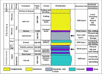
The stratigraphic description of the Gachsaran Formation is based on results of the Gachsaran Oilfield wells in the Dezful Embayment (Fig. 2) (Setudehnia, Reference Setudehnia1977; James & Wynd, Reference James and Wynd1965).
Stratigraphic position and tectonosedimentological descriptions of the Mid Miocene Gachsaran Formation. Modified from Motiei (Reference Motiei1993) and James & Wynd (Reference James and Wynd1965).

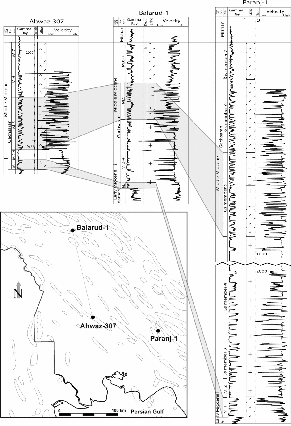
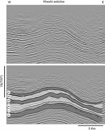
Member 1, also called Cap Rock, consists of 40 m of interbedded anhydrite and limestone associated with bituminous shale (in well Gachsaran 25). This member lies conformably on the Upper Oligocene–Lower Miocene Asmari Formation (Setudehnia, Reference Setudehnia1977) (Fig. 3). It acts as an important seal for the Asmari reservoir. Member 2 (115 m in well Gachsaran 21) is mainly composed of salt with some anhydrite and limestone intercalations. Member 3 (230 m in well Gachsaran 27) consists of thick anhydrite with subordinate salt (lower half of Member 3) and interbedded anhydrite, thin-bedded limestone and marl (upper half of Member 3) (Setudehnia, Reference Setudehnia1977). Member 4 (848 m in well Gachsaran 21), Member 5 (324 m in well Gachsaran 20) and Member 6 (286 m in well Gachsaran 18) are composed of mainly anhydrite with intercalations of marl, salt and limestone. Thick salt beds are the main constituents of Member 4 (Motiei, Reference Motiei1993). Member 7 (139 m in well Gachsaran 14) consists of alternating anhydrite, marl and limestone (Setudehnia, Reference Setudehnia1977), which is overlain conformably by the Mid Miocene Mishan Formation. Exposure of the salt beds at the surface is rare. Figure 3 shows stratigraphic columns of the Gachsaran Formation in three wells. The velocity log shows relatively high velocity variations, especially within members 2–5. Owing to the presence of salt, members 2 to 5 act as an incompetent unit and decollement level during the folding (Fig. 4). Underlying and overlying members 1 and 6 are sub-parallel horizons (Fig. 5).
Correlation of the Gachsaran Formation in three wells (Ahwaz 307, Balarud 1 & Paranj 1). Dominant lithology: Members 6 & 7 – anhydrite; Member 5 – anhydrite, marl and salt; Members 4–2 – salt; Member 1 – anhydrite.

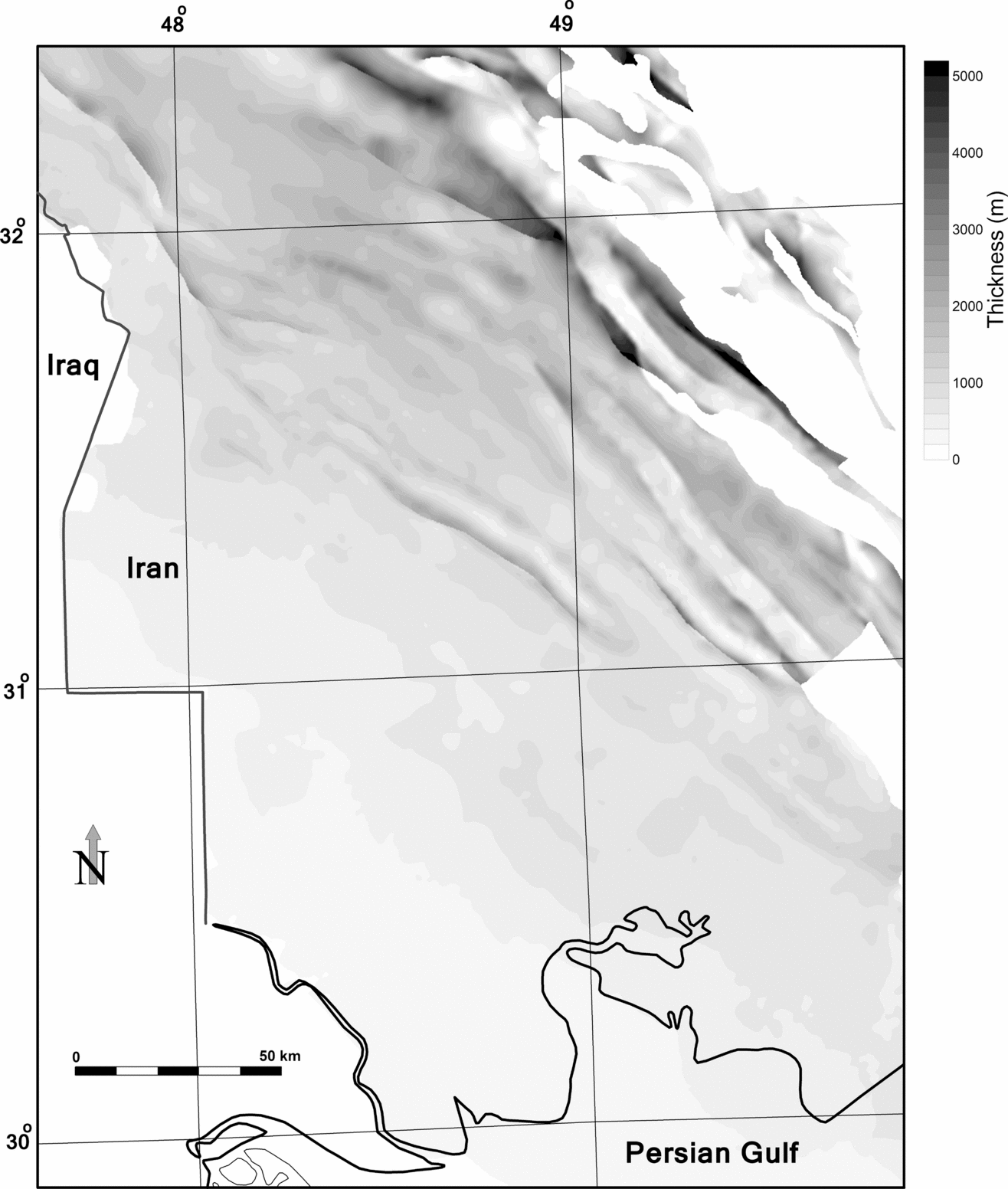
Isopach map of the Gachsaran Formation in the Dezful Embayment.

(a) Time-migrated seismic profile through the Khesht anticline (see Fig. 1 for location). (b) Geological interpretation of the seismic profile, showing members of the Gachsaran Formation. The Gachsaran Fm is detected based on notable divergency in reflectors, which caused discrepancy between pre- and post-Gachsaran geometry. A strong acoustic impedance (velocity × density) contrast between the top of Member 6 and Member 7 is noticeable.

The age of the underlying Asmari Formation is Oligocene–Early Miocene and the overlying Mishan Formation has a Middle Miocene age (James & Wynd, Reference James and Wynd1965; Motiei, Reference Motiei1993). Therefore, the Gachsaran Formation was deposited in Early to Middle Miocene time.
The thickness of the Gachsaran Formation in the Dezful Embayment increases from the SW to the NE. There are some examples of local thickening of the Gachsaran Formation in the southwestern flank of Zagros-type folds. For example, the thickness of this unit is increased by what are likely small thrusts in the southwestern limb of the Abteymour anticline (Abdollahie Fard et al. Reference Abdollahie Fard, Braathen, Mokhtari and Alavi2006) or maybe sliding over the Asmari Formation at a very early stage of folding. The salt of the Gachsaran Formation was considered to be the thickest basin-centre facies (Bahroudi & Koyi, Reference Bahroudi and Koyi2004). The maximum thickness was found just south of the Mountain Front Fault (Fig. 1). The maximum deposited thickness of the Gachsaran Formation in the Dezful Embayment was expected to be 1800 m (O'Brien, Reference O'Brien1950). However, drilling of some other fields showed that the thickness of the Gachsaran Formation can exceed 4000 m (Fig. 4). For example, in the well Zeloi 5 the Gachsaran Formation crops out at the surface and its measured thickness is 3447 m. This thickness is not a normal deposited thickness and it was likely subsequently increased by flow and thrusting of the incompetent members as shown later.
3.b. Seismic characteristics
3.b.1. Reflector pattern of the Gachsaran Formation in seismic profiles
The tectonic incompetency of the Gachsaran Formation is a remarkable indication of a seismic interpreter in the Dezful Embayment. In some cases, in which relevant well data such as geological markers and velocity in the well are not available, the Cap Rock (Gachsaran Member 1) is detected based on notable divergency in reflectors. The top Cap Rock is usually the lowermost divergent reflector (Fig. 5). The reflector pattern of incompetent members is chaotic, especially where they flow from the crest to the flanks of the underlying anticlines. There is a strong acoustic impedance (velocity × density) contrast between the top of Member 6 and Member 7. Therefore, the top of Member 6 is defined by a distinguished trough (normal display in SEG convention) or peak (reverse display in SEG convention) in seismic profiles, as the acoustic impedance of Member 6 is higher than that of Member 7 (Fig. 5).
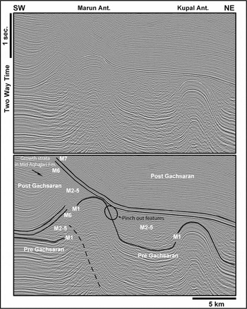
Reflectors of the upper Gachsaran and overlying Mid Miocene Mishan and Upper Miocene to Pliocene Agha Jari formations are bent upwards on both sides of the Gachsaran salt body (members 2–5 at the SW side of the Marun anticline, Fig. 6). In the extreme case (near the Marun structure), incompetent members breach the upper members and flow up in the form of a diapir or salt ridge (O'Brien, Reference O'Brien1950).
(a) Time-migrated seismic profile through the Marun and Kupal anticlines (see Fig. 1 for location). (b) Geological interpretation of the seismic profile, showing upwards bending and breaching of post-Gachsaran sediments. Members 2 to 5 show more incompetent behaviour; they escape from the top structures towards the adjacent synclines. A growth strata pattern is seen on the upper Agha Jari sediments of the Marun anticline southern flank.

Reflectors of the Agha Jari, Mishan and upper members of the Gachsaran Formation appear to be pulled up or turned up close to the middle Gachsaran bulge mainly consisting of anhydrite and salt. This suggests upward movement of incompetent material through the stratigraphic section in the form of a salt ridge. On the other hand, it could be argued that the inflated Gachsaran Formation on this seismic section has been formed in response to tectonic movements and loading by the thick Agha Jari clastic sediments within the SW syncline (Fig. 6).
3.b.2. Lateral velocity variation and processing
The incompetent members of the Gachsaran Formation are mainly a combination of anhydrite, shale and salt. The dominant rock governs the velocity of the whole swelling part. In the depocentre of the Gachsaran Formation (SW of the present Mountain Front Fault), salt is reported as the main deposit, whereas in the SW of the Dezful Embayment, shale content is the highest. In areas where the amount of anhydrite is high, the expected total interval velocity is high. On the contrary, dominancy of salt and shale leads to a relatively lower interval velocity. Therefore, the Gachsaran ridges show anomalous velocity behaviours. High velocity anomalies initiate velocity pull-up effects on the underlying reflectors, while a low velocity anomaly has the opposite results. Both cases affect the seismic quality of surrounding areas, especially the southern flank of the main anticlinal structure.
Usually conventional time-migrated seismic sections are distorted and obscure owing to the presence of inflated Gachsaran bodies (salt thickening) and related lateral velocity variations. In such conditions, strong lateral velocity variations, related to lithology contrasts between steeply dipping layers, bend the seismic rays like an optical lens and distort the sub-surface image. Seismic imaging of the steep flank of a salt ridge proved to be more challenging because the reflectors need to be migrated correctly.
For a CMP (Common Mid Point) beside the flank of a salt ridge, rays at near offsets propagate in the low velocity sediments, while the far offsets cross the high velocity salt body (Mougenot & Al-Shakhis, Reference Mougenot and Al-Shakhis1999). In this case, the Dix's hyperbolic moveout assumption is no longer valid and the stack is not a zero-offset section. Thus, pre-stack migration is required to image and correctly position the steep flanks. This technique is considered to be the appropriate method for imaging targets in the presence of overburden, especially in the presence of a salt body (Oezsen, Reference Oezsen2004). However, the quality of seismic data depends on the acquisition parameters. Owing to structural complexity, it is necessary to use larger offsets (distance between seismic source and farthest receiver) to reach a correct illumination of the whole salt mass (Mougenot & Al-Shakhis, Reference Mougenot and Al-Shakhis1999). Also the 2D seismic technique is unable to image a salt body owing to scattering ray paths and interference from out-of-plane reflections. In such a complicated case, 3D seismic migration is needed to avoid the interference of side effects and focus seismic energy.
In processing, preliminary knowledge of the sub-surface is required to produce a seismic image with sophisticated techniques that have been developed since the beginning of the 1990s. The only way to remove effects of salt halokinesis is to define the velocity variations by building a velocity model and performing depth migration, which compensates for ray-bending propagation effects (Mougenot & Al-Shakhis, Reference Mougenot and Al-Shakhis1999).
4. Role of the Gachsaran evaporites in the dynamics of folding
The stratigraphic column of the Zagros consists of several competent stiff layers that are separated by evaporitic or shale layers, involved in deformation as intermediate decollements (O'Brien Reference O'Brien1950; Sherkati, Letouzey & Frizon de Lamotte, Reference Sherkati, Letouzey and Frizon de Lamotte2006) (Figs 2, 3).
Plastic behaviour of the incompetent units within the Gachsaran Formation favours development of disharmonic folding above it; such folding can be completely decoupled from that of underlying formations (Fig. 6). Generally folds above the Gachsaran Formation are tight with short wavelengths in the Dezful Embayment.
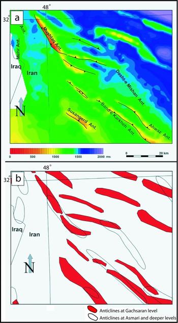
As explained before, the Gachsaran Formation is considered a main detachment level (upper detachment) in the Dezful Embayment. Therefore, the geometry of folds is expected to be different above and below this detachment level. A two-way time map of the top of the Gachsaran Formation (based on seismic data in the time domain with sea level as the datum plane) is presented in Figure 7a. Figure 7b shows the location of the anticlines in both the top Asmari and Gachsaran levels. Therefore, the location of structures in the top Gachsaran level is clearly different from structures in the top Asmari.
(a) Two-way time map of the top of the Gachsaran Formation from mean sea level. (b) Location of the anticlines in both the top Asmari and Gachsaran (red polygons) levels. Clear vertical differences between folds in size and location show that the Gachsaran Formation completely decoupled superficially from deeper structures.

5. Gachsaran Formation behaviour above Arabian-type structures in the Zagros foreland
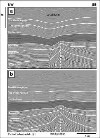
An onshore seismic line is shown in Figure 8, which orthogonally crosses the Hendijan High (for location see Fig. 1). Flow of the Gachsaran incompetent units controlled a local basin for sedimentation of post-Gachsaran syn-tectonic deposits (Fig. 8). This local basin was formed above the palaeo-high, possibly owing to withdrawal of the Gachsaran incompetent units. The Hendijan Fault Zone is present as a cluster of steep faults (white dashed lines, Fig. 8). The basement-seated Hendijan fault zone affected the Cretaceous and Lower Tertiary sediments as was discussed by Ahmadhadi et al. (Reference Ahmadhadi, Lacombe, Daniel, Lacombe, Lavé, Vergés and Roure2007). In contrast, flow of Gachsaran incompetent units controlled local basins for sedimentation of post-Gachsaran syn-tectonic deposits. The thick Agha Jari layers affected the Hendijan, as in this segment the Hendijan fault zone does not penetrate to the Upper Tertiary layers. It seems the movement of the deep-seated fault zone was suppressed by heavy post-Gachsaran overburden.
(a) Migrated seismic section crossing the Tangu anticline (Hendijan High). The location is shown in Figure 1. (b) Profile B is flattened at the top of the middle Agha Jari Formation. Note the thickening of the upper Agha Jari Formation at the top of the Hendijan fault. In contrast, lower reflectors show the presence of a palaeo-high through geological time, at least from Cretaceous time upwards. This could be interpreted as the influence of the Gachsaran Formation (highlighted area), which escaped from the higher palaeotopography towards the shoulders and caused the formation of a local depocentre in late Pliocene time. Therefore, this local depocentre is the result of salt withdrawal on the western flank of the Hendijan High (modified after I. Abdollahie Fard, unpub. Ph.D. thesis, Shahid Beheshti University, Reference Abdollahie Fard, Braathen, Mokhtari and Alavi2006).

6. Discussion
The deformation within the Gachsaran Formation, which led to its significant thickness variations around Zagros-type folds and the development of disharmonic folding (Talbot & Koyi, Reference Talbot, Koyi, Snoke, Tullis and Todd1988), mostly can be ascribed to flow of salt. On the other hand, thickness variations of Member 5 of the Gachsaran Formation are partially related to syn-deposition events (see on-lap features highlighted in Fig. 6). Sherkati et al. (Reference Sherkati, Molinaro, de Lamotte and Letouzey2005) and I. Abdollahie Fard (unpub. Ph.D. thesis, Shahid Beheshti University, Reference Abdollahie Fard, Braathen, Mokhtari and Alavi2006) also proposed that the ‘pinch-and-swell’ geometry of the Gachsaran Formation developed before the deposition of the lower Agha Jari Formation, which could result from either a depositional accumulation or an early migration. In both cases, it is necessarily linked to a first step in the folding process. Therefore, movement of Gachsaran salt driven by gravity towards the depressions (i.e. towards the synclines) has been proposed (Sherkati et al. Reference Sherkati, Molinaro, de Lamotte and Letouzey2005). This model supposes an early folding step during or just after deposition of the Gachsaran Formation that led to migration of salt towards the synclines. In contrast, O'Brien (Reference O'Brien1957) proposed salt migration after the deposition of the Gachsaran Formation. Verges et al. (Reference Verges, Goodarzi, Emami, Karpuz, Efstathiou, Gillespie, McClay, Shaw and Suppe2011) also addressed development of disharmonic folding across the upper mobile group (Gachsaran Formation) in terms of the lateral migration of evaporites. An important contribution of our study is to show that members 6 and 7 of the Gachsaran Formation have not participated in this lateral migration and that members 2 to 5 mainly acted as major incompetent units within the Gachsaran Formation.
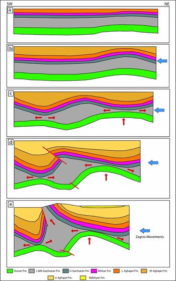
We propose a kinematic history where the Gachsaran halokinetic movement growth was initiated by Zagros contractional deformation in a conceptual model, presented in Figure 9. Homke et al. (Reference Homke, Verges, Miguel Garces, Emami and Karpuz2004), based on a magnetostratigraphic study, showed that the age of folding in the Lurestan region (west of the Dezful Embayment) started between 12 and 8 Ma. In the Dezful Embayment area no absolute dating is available, and based on the general age proposed for the Agha Jari Formation (James & Wynd 1968), folding could have started during Pliocene time and continued to date. The present model is a modification of a model that O'Brien (Reference O'Brien1946) suggested as a possible geological history of the Lali area (for location see Fig. 1). The layers of the lower Agha Jari are sub-parallel (Fig. 9a) while the layers of the middle Agha Jari show syn-tectonic geometries (growth strata, Fig. 9b). Compressional forces led to movement of the incompetent material within the Gachsaran Formation from the crest of the initial anticlines to the flanks (Fig. 9b). In addition, contractional forces caused thrusting within the Gachsaran Formation. These thrusts play an important role in the upward movements of the plastic material (Fig. 9c). A thrust has been formed within the Fars group and it is expected to be a future conduit for upward movement of plastic material. Also, truncation of the Gachsaran reflectors is possibly evidence of a local unconformity and early movements during Gachsaran sedimentation.
Conceptual kinematic model explaining the deformation of the Gachsaran Formation (modified after the O'Brien (Reference O'Brien1946) model in the Masjed Suleyman area). (a) Subtle tectonic movements during deposition of the Gachsaran–lower Agha Jari. (b) Onset of the Zagros orogeny and disharmonic folding. (c) Southwestward shift of the shallower anticline above the Gachsaran detachment and flow of the incompetent members of the Gachsaran Formation by tightening and uplifting of the deeper anticline. (d, e) Thrusting within the Fars Group as a conduit for Gachsaran salt diapirism (modified after I. Abdollahie Fard, unpub. Ph.D. thesis, Shahid Beheshti University, Reference Abdollahie Fard, Braathen, Mokhtari and Alavi2006).

Talbot & Koyi (Reference Talbot, Koyi, Snoke, Tullis and Todd1988) discussed the role of shortening in Gachsaran Formation flow in anticlines. As seen in Figure 9, the thick syn-tectonic Agha Jari sediments in the synclines led to local subsidence. Incompetent units within the Gachsaran Formation below this thick clastic sequence laterally flow to both sides. So possibly loading of Neogene clastic rocks (Agha Jari and Bakhtyari formations) in synclines could be the other reason for the flow of the Gachsaran Formation. In this case the thickness of the swollen part of the Gachsaran Formation may exceed 4000 m (Figs 2, 4). As shown in Figure 8, local flow of the Gachsaran controlled for instance the location of the local subsiding basin formed above the Hendijan High.
In extreme cases, incompetent members breach the upper members and flow up to the surface (Fig. 9). Therefore, the upper Gachsaran and overlying Mid Miocene Mishan and Upper Miocene to Pliocene Agha Jari formations are bent upwards on both sides of the Gachsaran inflated body (Fig. 9d).
Contractional deformation during the last phase of the Zagros orogeny was preferentially partitioned into the salt body, squeezing the salt-stems and adding ‘tectonic pressure’ to the natural buoyant pressure within the salt bodies. Both passive and active (forceful intrusion) types of halokinesis play a major role in the configuration of the inflated Gachsaran Formation; they were not formed solely by contractional movements and buoyancy, but also complementary sinking of the overlying higher-density material (Twiss & Moores, Reference Twiss and Moores1992) such as the Agha Jari deposits, which accelerated this phenomenon.
The behaviour of the Gachsaran Formation as a major decollement unit could be seen only in the Dezful Embayment. Its facies towards the Fars and Lurestan regions change and its salt component decreases, which favours development of a completely different style of deformation (Mouthereau, et al. Reference Mouthereau, Tensi, Bellahsen, Lacombe, Deboisgrollier and Kargar2007; Verges, et al. Reference Verges, Goodarzi, Emami, Karpuz, Efstathiou, Gillespie, McClay, Shaw and Suppe2011)
7. Conclusions
(1) Thickness variations of the Gachsaran Formation, instead of sedimentary dynamism, are mostly related to flow and thrusting of its incompetent members.
(2) Usually conventional time-migrated seismic sections are distorted and obscured owing to the presence of Gachsaran ridges and related lateral velocity variations. In such conditions, strong lateral velocity variations, related to lithology contrasts between steeply dipping layers, bend the seismic rays like an optical lens and distort the sub-surface image
(3) Syn-tectonic Agha Jari and Bakhtyari deposits actively influenced the mechanical balance and the kinematic evolution of the folds developed in the Dezful Embayment.
(4) A possible mechanism for deformation of the Gachsaran Formation is flow of salt and of other incompetent rocks (members 2–5). Progressive deformation accelerated this mechanism and blocked incompetent sediments between pre-Gachsaran anticlines and post-Gachsaran synclines, squeezed up to the surface just after erosion of the superficial crest of Fars anticlines.