

1 Introduction
This analysis of certain rock carvings at Jabal Jusasiyah Qatar is in the form of an Archaeological Report, but is not a full Archaeological Survey. This has been carried out by others – (Hans Kapel Arryan, Qatar National Museum Journal, 1983, pp. 1–126) for Jabal Jusasiyah Qatar. A systematic procedure is adopted for the analysis of a number of these petroglyphs at the sites in Qatar.
I discuss the evidence of Harald's saga Sigurðarsonar and Yngvar's saga Viðfọrla which together with the archaeological evidence may show a Varangian Viking presence in the Red Sea Area. This is regarded along with supporting evidence for portage (which may be applied to the Red Sea area) in Yngvar's saga Viðfọrla, and Harald's saga Sigurðarsonar.
I suggest that portage is the only way that access could be gained to the Red Sea via what is now Suez Bay, thereby to the Indian Ocean and Jabal Jusasiyah Qatar in the Persian Gulf. In addition the mid-ninth-century CE manuscript evidence of Ibn Khurradadhbih, (about the routes of Rus traders) is highlighted.
I consider the Varangians’ probable close links to the Greek navigational techniques, of which circumpolar navigation is mentioned in Homer's Odyssey. Also some historians credit the invention of the astrolabe to Hiparchus, and some to Hypatia of Alexandria. The Viking ‘weathervane’ may have been an adaptation of the astrolabe to measure the height of the sun.
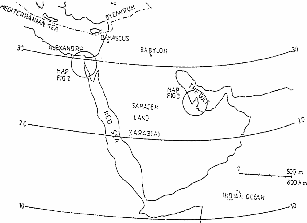
It should be noted that the ‘Persian Gulf’ is also known as the ‘Arabian Gulf’ or ‘the Gulf’ in Qatar and the Trucal Coast. This is the Gulf to the east of what is now Saudi Arabia and the Gulf States. The ‘Red Sea’ or ‘Arabian Gulf’ is the Gulf to the west of Saudi Arabia reaching up to Suez Bay and the Gulf of Aquabah. The ‘Indian Ocean’ lies to the south of Saudi Arabia, Yemen and Omar. (see Map 1).
Arabia and Byzantium

2 Methods
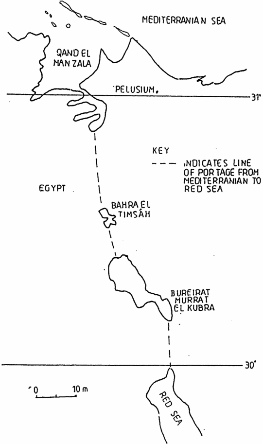
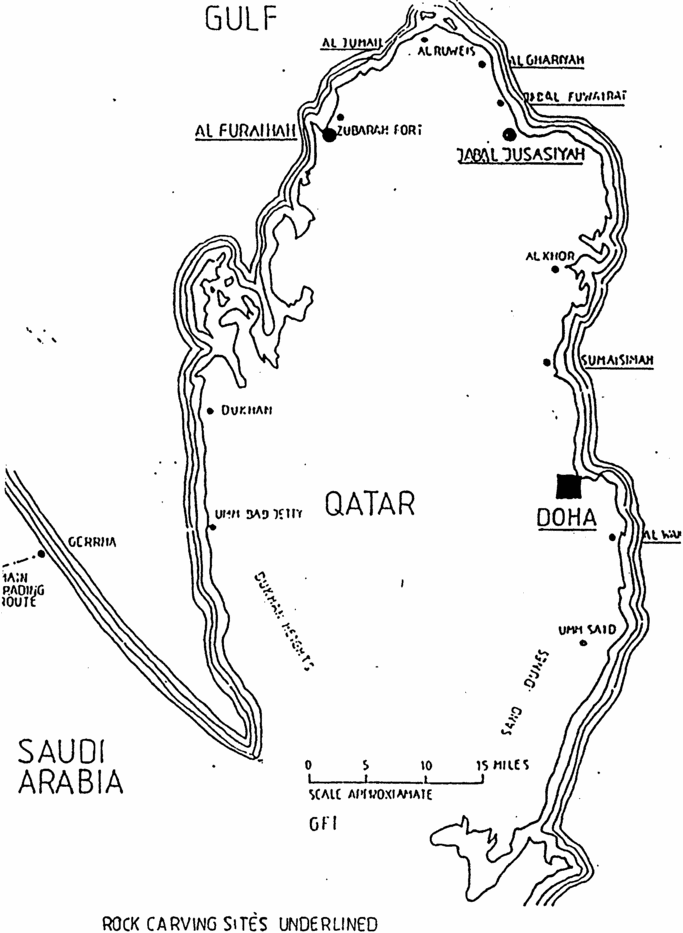
This paper has been prepared in the format of an Archaeological Report. Map 1 depicts Arabia and part of Byzantium. Map 2 shows a possible portage (a method of sliding a boat on runners overland between two areas of water) route from Pelusium on the Mediterranean shore to the Red Sea. Map 3 shows the State of Qatar, indicating the site of Jabal Jusasiyah. Four photographic plates by the author illustrate the site and some of the petroglyphs. The appendix lists H. Kapel, Arryan-Qatar National Museum Journal (1983) Survey of ship carving sites which are referred to in the text and to the corresponding Arryan-Qatar National Museum Journal page. To orientate the reader, a summary of the H. Kapel Survey, and W. Facey analysis is given in Part 5 – Documentary Evidence.
Possible portage route from Pelusium to the Red Sea

Qatar showing Jabal Jusasiyah

3 Description of the site at Jabal Jusasiyah, Qatar
The Qatar Peninsular is mainly flat with sandy desert in the south and stony desert in the north. There are rock outcrops at the Dukhan heights on the west coast and the area of Twar al Huraithi east of the heights. There are some low limestone rock outcrops along the north-east coastal areas. Located between Jabal Funair to the north and the fishing villages of Al Khor to the south is the rock outcrop of Jabal Jusasiyah, discussed in this paper (See Map 3).
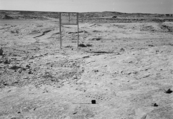
The immediate area of the rocks at Jabal Jusasiyah are photographed, see Plate 1.
Jabal Jusasiyah site looking south: photoraph by the author.

There are very high sand dunes in the south east of Qatar which run along the coast south of Umm Said harbour-this would have provided a very good viewing point for the ships. (See Map 3).
The location of Jabal Jusasiyah is partially surrounded by stony desert and sandy desert. The main limestone outcrop is 700 × 50 m although H Kapel states “the whole area extends to some 30 hectares” (Ibid., p. 124).
For other rock carving sites in Qatar, refer to Map 3, and Part 11 – Conclusion.
4 Environment
What we find at Jabal Jusasiyah is precisely what Nearchus was asked to find by Alexander (Anabasis of Alexander-Arrian book VII (Translated P. A. Brunt Arrian, Anabasis of Alexander 1983 (2000) pp. 274–277), that is the primary requirements for sustaining life in a barren area. Nearchus is a commander who with some men is sent on a voyage of discovery in 324 BCE. Alexander sends the Nearchus expedition out from Babylon to sail as far as they could on the east of the Red Sea (Persian Gulf) and discover the regions there. The text (Ibid., pp. 274, 276) confirms that Nearchus completed his voyage around the Persian Gulf. The coast has good fishing and fresh water is available in wells. There is some vegetation – Abal bushes and tufts of ailqi or qassis, the remains of vegetation which has grown after rain providing grazing for sheep, goats, and camels. The northern Qatar coast provides good pearl banks, and Jabal Jusasiyah may have been one of the many gathering places for this activity.
5 The Documentary Evidence Jabal Jusasiyah Qatar
Summary H. Kapel, Arryan-Qatar National Museum Journal 1983 (Archaeological Survey of Jabal Jusasiyah Site, Qatar)
Abstract
900 single figures first noted in 1956, not properly recorded until 1974. Discusses the rock carvings briefly, the main thrust of the work being the systematic survey recording.
Objective
To index as many of the rock carvings in the area as possible and record positions.
Method
Mapping carried out by a combination of polar measurements and triangulation.
The Environment
Qatar and around Jabal Jusasiyah
Classification
Rock carvings divided arbitrarily into groups – see H. Kapel, 1983, Table 1 ‘Parts’.

Description of Carvings
1) Ships, Bas Relief
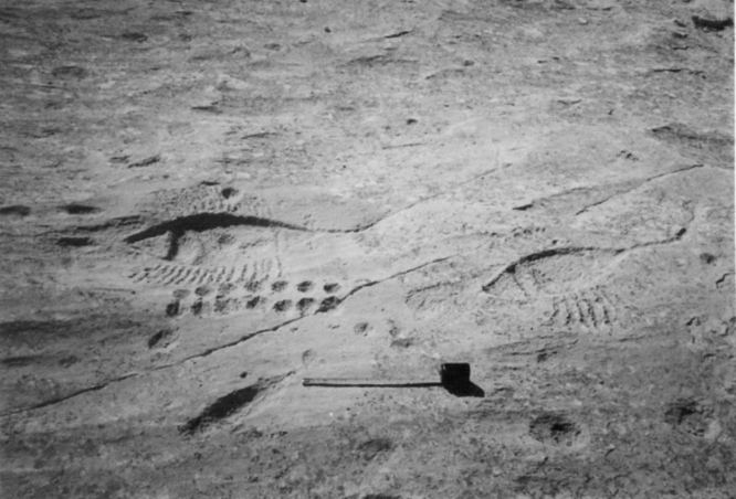
Vessels shown on plan, with varying depths of relief, with crossing ribs, thwarts, and placing of masts. Typical detailed examples of group Sites 161 (see Plate 3), 162, 174, and 175. In some areas there is long line anchor ropes. Kapel cites ‘European’ type anchor, but see W. Facey – extract below.
The number of oars varies, but 6 and 8 are frequent. Oars only shown by individual lines. The blades shown only occasionally on Site 174 and 286. Some vessels are shown sharp – sterned and these are not found on Qatar's coasts today.
2) Ship, line drawings
Main Site 421. Lines are of pointed dots. The vessels large square sterned sailing ships of various types. ‘Arab’ shape flat stone anchors as in Sites 421, 479, but see W. Facey, below. Site 421, 484 reminiscent of battil. Site 204 maybe baghlah.
3) Game boards, rows
See H. Kapel table of carvings.
4) Game boards, rosettes
Circle of holes around a hole in the centre. Conclusion is that these are boards for a game.
5) Figures resembling animals
Mainly Sites 128, 129, 336, 421, 495, 532, 533.
6) Footprints
These have an important role in European rock carvings, (such as at Tanum Sweden) especially in Scandinavia. Sites 22, 118, 295, 326, 465.
7) Symbols and signs
Similar to written characters.
8) Systems of Connected holes
Cup shaped indentations discussed.
9) Other Carvings
Thought to represent fertility symbols, especially Sites, 414, 417, 418, 420.
The opening of the female sexual passage is a motif well known on rock carvings in all parts of the world.
Dating the carvings
Group 2 ships are quite clearly European. Site 204 is a Portuguese frigate of the sixteenth century.
The game boards of Group 3 and 4 cannot be dated, as is the case with Group 5, the animal like figures. Group 6 are ‘old’, but lack a comparison with other such carvings in the Arab world.
Fragments of finds in the area date from 1200 to 1800 CE. This is not exhaustive. Kapel stresses the need for further archaeological examination of the area, and nearby settlements.
The Report then details 1/10 Scale drawings of some of the carvings. There is a further ‘Appendix’ folio of scale drawings.
(William Facey, Proceedings of the Arabian Seminar, PSAS17, 1987. (pp. 199 to 209)
The Boat Carvings at Jabal Al Jusasiyah Northwest Qatar (Summary).)
Hans Kapel's investigation and summary of the site was carried out in 1974 and published in Arryan Qatar National Museum Journal No 8, October 1983.
Facey describes the 900 total single figures, analysed by Kapel to 580 numbered sites. Of these 141 boat carvings were counted. Based on representation and carving techniques, Facey grouped these as:
1) Those shown on plan (124 carvings)
2) Those shown in elevation (17 carvings)
Boats in Elevation
The first-discussed is clearly a battil, the second is equally clearly a baggarah. Facey proceeds to describe the construction of these dhows – e.g. use of stitching instead of nails, that they have a shallow draught and need a deep rudder for stability. Facey makes the point that the battil and baggarah at Jabal al Jusasiyah Cannot be dated earlier than C1000–1200 CE.
Boats in Plan
Facey makes the important assertion that these petroglyphs are in fact boats rather than scorpions or fertility symbols, which has been claimed. Both sets of petroglyphs were carved using a pointed metal instrument. He observes with one exception – Site 161 (this article Plate 3) where 15 oars are depicted per side, the boats have a maximum of 10 or 11 oars per side. Since four-pronged grapnel anchors are shown on Iraqi boats dating to early the thirteenth century CE, this type of anchor cannot be assumed to post-date 1500 CE.
Crucially, Facey points out that two vessels (Kapel Site 175) have steering oars rather than rudders, giving a date of c.1000–1200 CE. He notes Baden fishing boats are transom-sterned with steering rudders on each side. There is further discussion as to whether the boat carvings and cup-marks are contemporary.
Facey cites the work of Beatrice De Cardis's team of 1973, who discovered pottery fragments near to habitation mounds of tenth-eleventh centuries CE (De Cardis 1978 pp. 190–191). There is further discussion about the orientation of towns circa 1765 CE and Niebur's documentation (Niebur 1774, pp. 274) investigates the purposes of Jabal Jusasiyah, which he suggests maybe linked to pearling. He highlights the profusion of game boards – 400 counted by Kapel.
Finally, Facey discusses the dating of the rock carvings, concluding that this might be between tenth-sixteenth centuries CE. The boats shown in plan, particularly with steering oars could be older.
There is an interesting mid-ninth-century Arab manuscript extract from Ibn Khurradadhbih: Kitab al-Masalik wa-l-Mamalik which tells about the Rus trading routes to the east.

(Ibn Khurradadhbih: Kitab al-Masalik wa-l-Mamalik (Bibliotheca Geographorum Arabicorum, volume 6, pp. 154–155, 1967).
The Arab Text tells of overland and sea routes to the Sind (Pakistan) Hind (India) and China by Viking Age Rus (Russian) Traders.
The dating of the Ibn Khurradadhbih manuscript – mid ninth century CE coincides with the Viking Age CE 800–1050 or 1070.
There is circumstantial documentary evidence for the existence of the site of Jabal Jusasiyah in Arrian's Anabasis of Alexander where Nearchus reports his voyage to the Persian Gulf and the reasons that Alexander sent him there. Unfortunately we are not given an account of what he found there, only what he was seeking to find, and the fact that he was in the area. It is inconceivable that he would not have found Jabal Jusasiyah given the nature of the site as described above.
(Anabasis of Alexander-Arrian book VII (Translated. P. A. Brunt Arrian Anabasis of Alexander 1983 (2000) pp. 274–276).
“But Nearchus says that he himself forbade this; having completed his voyage round the Persian Gulf, he had to report to Alexander on the commission for which he had been despatched, that in fact he had not been sent to navigate the Ocean, but to reconnoitre the coast lying on the Ocean, the inhabitants of the coast, its anchorages, water supplies and the manners and customs of the people, and to discover if any part of the coast was fertile or not; and this was the reason that Alexander's force came through safely, for they would have been lost if they had sailed past the desert parts of Arabia”. (Ibid., pp. 275, 277). This is important primary evidence of circumnavigation of the Persian Gulf in the late fourth century BCE.
For more recent archaeological documentation of Jabal Jusasiyah, the main work is Hans Kapel Arryan – Qatar National Museum Journal (1983) pp. 1–126. This is a systematic descriptive work presenting the findings in summary. There is further analysis of H. Kapel's work (mentioned above) by W. Facey, in Proceedings of the Arabian Seminar (BM) 17 (1987) pp. 199–209. See also the bibliography below.
6 Classification – Jabal Jusasiyah Qatar
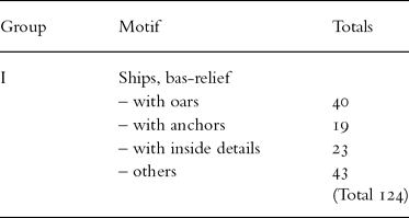
Kapal groups the rock carvings by type (I–IX). In this paper I consider certain of the carvings of Group I (ship type ‘bas relief’) see Table 1 below. For the remaining rock carvings, see H. Kapel (summary above), or Table 1 H. Kapel, Arryan-Qatar National Museum Journal (1983) p. 122.
7 Detailed description of petroglyphs ships Group 1 at Jabal Jusasiyah Qatar
Table 1 below, lists the petroglyph groups considered in this paper from Group I of H. Kapel's summary of the site.
Note 1. For the remaining rock carving groups refer to H. Kapel's Table 1 Ibid., p. 122 and the appendix to his report H. Kapel, Arryan-Qatar National Museum Journal, Appendix, (1983).
Note 2. The seventeen line drawings of ships (H. Kapel Arryan-Qatar National Museum Journal (1983) p. 122 Table 1, Group II) have been omitted from this analysis as these are known to be from CE 1400. I have no reason to question H. Kapel's dating of the seventeen line drawings, which was based on the types of vessels represented which are large square – sterned sailing ships.
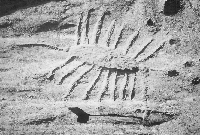
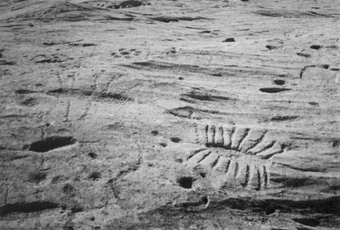
Note 3. For site looking south, see Plate 1. For Site 321, see Plate 2. For Site 161, see Plate 3. For Sites 320, 321, see Plate 4.
Jabal Jusasiyah Group 1 Site 321 Bas relief ship with oars and anchor: Photograph by the author.

Jabal Jusasiyah Group 1 Site 161 Bas relief ships with oars: Photograph by the author.

Jabal Jusasiyah Group 1 Sites 320, 321, Bas relief ships with oars: Photograph by the author.

8 Dating evidence/finds
Dating of the carvings presents certain problems. W. Facey in Proceedings of the Arabian Seminar (BM) 17 (1987) pp. 199–209 (summarised above) compares and analyses the site at Jabal Jusasiyah. Ongoing archaeological work at the site, and in other areas of the Gulf States is reported by F. Gillespie. See also Part 11 – Conclusion. The type of carvings has been shown to be an indicator of the age of the carvings. The evidence (Anabasis of Alexander – Arrian book VII (Trans. P. A. Brunt Arrian Anabasis of Alexander 1983, pp. 274–276) as discussed in ‘The documentary evidence’, indicates the likelihood that Nearchus surveyed Jabal Jusasiyah on behalf of Alexander. The nature of the site (see Part 3) corresponds to the reasons given and instructed to Nearchus to explore the Persian Gulf area in 323 BCE.
After examination of the site, Kapel stated
“. . . of what is possibly the remains of a settlement in the immediate neighbourhood showed ceramic fragments everywhere in the sand between the rocks. These ranged from 1200 to 1800 CE, and were mainly from the fifteenth to sixteenth centuries and from the nineteenth century”. (H. Kapel, Arryan-Qatar National Museum Journal (1983) p. 113).
However, “. . . a terminus ante quem of c.1000–1200 CE “for two of the ships on the best Site 175, was suggested by W, Facey in Proceedings of the studies of the Arabian Seminar 17, (1987) p. 201.
The system of cup marks forming parallel rows or rosettes are a game called ‘Al Hawailah’ or Mancala’, “. . . which can be traced back to at least 1400 BCE.” Ibid., p. 126. Neither the cupmarks, nor the ceramic fragments found at the site infer a date for the Group 1 bas relief petroglyphs. Interpretation and discussion of the ship carvings are given below.
9 Interpretation – Jabal Jusasiyah Qatar
At this site, the type of petroglyph may give the only clue as to its dating, and thereby to its interpretation. The Jabal Jusasiyah Group 1 bas relief ships with 6–8 oars (Site 53, Site 161, Site 175) (Ibid., pp. 45, 47). Also Site 10 H Kapel, Arryan-Qatar National Museum Journal Appendix (1983) (p. 15); Sites 188 and 202 (Ibid., p. 25). Site 215 (Ibid., p. 27). Sites 320, 321, 326 (Ibid., p. 33). Site 513 (Ibid., p. 43), all these show similarities to Skuldelev type 3 ships. Of the above mentioned Group 1 bas relief ship petroglyph sites, Site 161 (H. Kapel, Arryan-Qatar National Museum Journal (1983) p. 47) and Site 320, 321, H. Kapel, Arryan-Qatar National Museum Journal Appendix (1983) p. 33 have unusual anchors. Note, Site 321 (bas relief ship) is shown in this article, (Plate 2).
The main group of bas relief ship petroglyphs are concentrated around Site 175 (H. Kapel, Arryan-Qatar National Museum Journal (1983) p. 45), steering oars are also shown on the starboard of ships at this site. The number of oars varies, but 6 and 8 are frequent. Several of the vessels have an appendage, or outboard apparatus e.g. Site 161 (Ibid., p. 47) and Site 175 (Ibid., p. 45).
10 Discussion
It may be fanciful to speculate that the Varangians may have had access to Ptolomy's Almagest, (Original MS dating to the second century CE – Ptolemy CE 100 to 178) however Homer's Odyssey would have been well known and more accessible to them.
Evidence of sea-borne travellers using circumpolar stars for a bearing in the eighth century BCE, can be found in Homer's Odyssey as originally referred to by B. McGrath in Navigation News (1991) p. 14.
Translated A.T. Murray, Homer Odyssey (2002) pp. 200, 202
“Gladly then did noble Odysseus spread his sail to the breeze, and he sat and guided his raft skilfully with the steering oar, nor did sleep fall upon his eyelids, as he watched the Pleiades and late setting Boőtes, and the Bear, which men also call the Wain, which ever circles where it is and watches Orion, and alone has no part in the baths of Ocean. For this star Calypso, the beautiful goddess, had bidden him to keep on the left hand as he sailed over the sea.”
(J. Engström and P. Nykänem Fornvännen (1996) pp. 137–142) discuss “New Interpretations of Viking Age Weathervanes. The so called weathervanes (Type II) contain marks which were probably used for measurement of the height of the Sun.” (Ibid., p. 139). Some historians credit the invention of the astrolabe to Hiparchus (second century BCE). The Viking ‘weathervane’ may have been an adaptation of this.
Engström and Nykänen state, “. . . that weathervanes were not merely objets d'art or symbols of rank but also played an important part as navigational instruments” (Ibid., p. 137).
I endorse this view, and I would like to add that it is likely the Vikings may have utilised the circumpolar navigation information in Homer's Odyssey. This would have enabled celestial night-time navigation, as mentioned above in Homer's Odyssey. In other words navigation by night may have been easier than sailing by day.
Harald's saga Sigurðarsonar might be regarded as an “inventive source” incorporated by Snorri Sturluson into Heimskringla in the thirteenth Century. The saga refers to “Saracen land” or Serkland in Africa.
“LagÞist hann Þá meÞ her sinn vestur i Afriku er Væringjar kalla Serkland Efldist hann Þá mjög aÞ liÞi” (Islenzk Fornrit XXVIII, vol III (1941–51) p. 76)
“He then went with his troops westward to Africa, which the Væringer call Saracen's land where he was strengthened with many men” (Translated S. Laing Heimskringla (1961) p. 164)
It is perhaps worth noting that the north-east coastal region of Africa adjoins the Red Sea. Secondly we can read “Serkland” (Saracen Land) to mean Africa only as implied above. My interpretation is that a Saracen is a nomad of the Syrian and Arabian desert and that Saracens Land is the area of the Syrian and Arabian desert. It should be noted that there is no evidence from the time Harald was in the Byzantine to show that the Varangians fought in Africa. Therefore this saga has to be interpreted in conjunction with all the other evidence.
Yngvar's saga Viðfọrla also records exploits in the area although the writer's geography might be regarded as suspect. However the Red Sea is clearly mentioned twice. Can the Red Sea be regarded as the actual furthest extent of Yngvar's travels and ‘enda heims’ – the Red Sea – world's end?.
“Þadan fellr ok aunnr til Raudahafs, ok er Þar micill suelgr, sa er Gafi er kalladr. A milli siofar ok àrinnar er ncs Þat, er Sigæum heitir. Ain fellr skaml, adr hon fellr af biargi j Raudahaf, ok kaullum uer Þar enda heims” (Emil Olson Yngvars saga Viðfọrla (1912) p. 18)
“and from the same spring another river flows into the Red Sea where it creates the huge whirlpool we call Gapi. There's a tongue of land between the sea and the river, called Siggeum, and after the river has flowed only a short distance it pours down over the cliff into the Red Sea, and that's where we think the world ends”.
(Trans H. Palsson, p. Edwards Vikings in Russia Yngvar's saga and Eymund's saga (1989) p. 54)
Yngvar's saga is mainly about an expedition to Russia, and yet above it mentions the Red Sea located in the Middle East. The sagas mention portage a number of times such as in Yngvar's saga Viðf'rla:
“Þa er voradi, biozt Ynguar brutt, en bad drottningn heila sitia med sinu folki. Ynguar for Þar til epter anni, at hann kemur at fossi myclum ok Þraungum gliufrum. Þa uoru hafer hamrar, suo at Þeir drogu upp j festum skip sin.” (Emil Olson Yngvars saga Viðf'rla (1912) p. 16).
“In the spring, Yngvar prepared to set out once more and took leave of the queen and her people. He sailed up-river until he came to a great waterfall in a narrow gorge with high cliffs, so that they had to haul the ships up by cables and after portage, refloat their ships”.
(Trans H. Pálsson, p. Edwards Vikings in Russia Yngvar's saga and Eymund's saga (1989) p. 53).
11 Conclusion
There is ample evidence for portage which would make the traverse of land between Pelusium and the Red Sea well within the capabilities of the Vikings. (See Maps 1 & 2, Appendix 1)
The use of bearing dial and Iolite crystal would also have been limited although not impossible to use, since there is little cloud and the sun is more or less directly overhead for most of the time in the Middle East.
The evidence for travel by night and the use of circumpolar stars for a bearing and ‘weather vane’ (adapted astrolabe) for travel by day would seem to be a safe assumption for the voyage from the Red Sea to Qatar. The quotation above – Part 10 – from Homer supports this assertion.
The Jabal Jusasiyah bas relief ship carvings are, as already mentioned, unique in the Middle East and also the world. M. Rice mainly discusses the cup marks at the site. M. Rice, The Archaeology of the Arabian Gulf c 5000–323 BC (1994). There are other ship carvings at Jabal Fuwairat just north of Jabal Jusasiyah (see Map 3), and also at the Huwar Island Archipelago. The latter features in the UNESCO ‘Report on Human Activity on the Hawar Archipelago’, by F. Gillespie from her survey of 2003, this appears on the UNESCO ADIAS web-link to Bahrain. “However the Hawar carvings were all canoe shaped vessels without oars, but some had stone anchors. Some were (carved) very large, the largest recorded measured over 2 metres” (e-mail, June 2005). I suggest that none of the Middle East dhows, unchanged for centuries – The Sambuk, Boom (most common of the dhows in the Persian Gulf) Baggala (currently the largest although there were larger dhows in the past), the Lamm dhow (the smallest) and the Gharjah, together with the other dhows scheduled in Appendix 2, have ever resembled any of the bas relief ship carvings of Group I at Jabal Jusasiyah. I would suggest that by consideration of the type of boats carved in the stone (similar to Skuldelev 3 and 5 Viking ships), this may be a crucial reason for the first millennium ‘Viking Age’ dating interpretation for the Group 1 Jabal Jusasiyah basrelief ship carvings. Skuldelev 3 is a cargo vessel and Skuldelev 5 a Viking warship – from the evidence of the Group 1 petroglyphs, (number of oars, etc.) both types of vessel may have been present at Jabal Jusasiyah.
Above in Part 8 I have shown ample evidence of portage, (prior to embarking on a journey to the Persian Gulf) and the navigational abilities of the Vikings to show that a voyage from the Red Sea to Qatar in the Persian Gulf was perfectly possible and within their capabilities especially in a Skuldelev type 3 vessel. The extent of portage is 20 miles from the bay of Qand el Manzala (by ancient Pelusium) to the Lake of Bahrael Timsah, then 8 miles portage to the Lake of Bureirat Murrat el Kubra. Finally 10 miles portage to the Red Sea Gulf. See also – Erik Nylen Vikingaskep mot Myklagard Krampmacken Bulverksbåten (1986), Map 2. In an experimental expedition through eastern Europe, he confirmed that a ship 8 × 2 metres with 9–13 crew would have been the optimum vessel for travel with extensive portage. These details correspond to the Skuldelev 3 (six to eight oars) and Skuldelev 5 (twelve oars) Viking ships as mentioned above.
The Viking period may be the only period where ships had pointed bows and sterns, and with oar arrangements which are similar to the bas relief ships Group 1 (see Plate 2) as found at Jabal Jusasiyah and of a size and type as suggested by the carvings. I further suggest that the Group 1 bas relief ship carvings, Sites 53, 161, 175, H. Kapel, Arryan-Qatar National Museum Journal (1983) pp. 47, 45, and Sites 10, 144, H. Kapel, Arryan-Qatar National Museum Appendix (1983) pp. 15, 21, also Sites 188, 202, Ibid., p. 25, Site 215 Ibid., p. 27, Sites 291, 313, Ibid., p. 31, Sites 320, 321, Ibid., p. 33, Site 513, Ibid., p. 43, Site 566, Ibid., p. 47, and Site 583, Ibid., p. 49, all as concentrated around Site 175 were carved by Varangian Vikings. This assertion is based on the reasons stated above, and also considering the similarities of the Group1 bas relief ship carvings as detailed above, to the Skuldelev 3 (six to eight oars) and Skuldelev 5 (twelve oars) Viking ships. W. Facey mentions “steering oars rather than rudders” for two of the ships on the best Site 175. W. Facey Proceedings of the Studies of the Arabian Seminar 17 (1987) p. 201.
In consideration of the primary evidence which includes: ‘Saracenland’ is mentioned in Harald's saga Sigurðarsona; the Red Sea, portage and Africa is mentioned in Yngvar's saga Viðfọrla – both sagas date from thirteenth century CE but are set in the Viking age.
There is evidence of circumnavigation in the Persian Gulf in the Anabasis of Alexander Arian book VII. This is of the late fourth century BCE.
Ibn Khurradadhbih describes Rus activities as far east as al Sin, and a North African sailing route as one of the two types of access used.
There is also the evidence of Viking navigation using the ‘weather vane’ thought to be based on the Astrolabe – although additionally it is widely known that they may have also utilised the ‘bearing dial’ and iolite crystal.
Further and supplementary archaeological evidence is provided by the petroglyphs of Jabal Jusasiyah in north west Qatar, which it is asserted, are based on the Skudelev 3 and 5 type Viking ships.
This similarity is based on the following factors suggested by the carvings:
– The size and type of the ships shown in the carvings.
– The number of oars.
– The pointed bows and sterns.
– The steering and mast arrangements.
– Indigenous ship types being ruled out as candidates for identification.
The evidence above considered jointly with the manuscript evidence, maintains the central contention of my article- that is the presence of Varangian -Værinjar and/or Rus Vikings at Jabal Jusasiyah, Qatar in the Persian Gulf during the Viking age. That is to say circa CE 800–1070. Varangian activity being circa CE 1034–1070. This is further south east than hitherto assumed.
Appendix