Introduction
The paleoenvironmental history of northwestern Russia during the late glacial and the Holocene has been the focus of many studies, especially in recent years (e.g., Davydova et al., Reference Davydova, Kabailene, Raukas and Yakushko1992, Reference Davydova, Subetto, Khomutova and Sapelko2001; Arslanov et al., Reference Arslanov, Savelieva, Gey, Klimanov, Chernov, Chernova and Kuzmin1999, Reference Arslanov, Savelieva, Klimanov, Chernov, Maksimov, Tertychnaya and Subetto2001; Wohlfarth et al., Reference Wohlfarth, Bennike, Brunnberg, Demidov, Possnert and Vyahirev1999, Reference Wohlfarth, Filimonova, Bennike, Björkman, Brunnberg, Lavrova and Demidov2002, Reference Wohlfarth, Schwark, Bennike, Filimonova, Tarasov, Björkman and Brunnberg2004, Reference Wohlfarth, Tarasov, Bennike, Lacourse, Subetto, Torssander and Romanenko2006, Reference Wohlfarth, Lacourse, Bennike, Subetto, Filimonova, Tarasov and Sapelko2007; Subetto et al., Reference Subetto, Wohlfarth, Davydova, Sapelko, Björkman, Solovieva and Wastegärd2002; Subetto, Reference Subetto2009; Novenko et al., Reference Novenko, Volkova, Nosova and Zuganova2009; Payne et al., Reference Payne, Malysheva, Tsyganov, Pampura, Novenko, Volkova and Babeshko2016; Gromig et al., Reference Gromig, Wagner, Wennrich, Fedorov, Savelieva, Lebas and Krastel2019; Savelieva et al., Reference Savelieva, Andreev, Gromig, Subetto, Fedorov, Wennrich and Wagner2019; Tarasov et al., Reference Tarasov, Savelieva, Long and Leipe2019). However, spatial and temporal patterns of environmental changes in many localities of this vast region during the glacial/interglacial transition remain poorly studied due to the limited number of the records with reliable geochronological and paleoenvironmental data.
The Valdai Highlands (Fig. 1) is one such area with a poorly studied paleoenvironmental late glacial and Holocene history. The region was in the ice-marginal zone of the Scandinavian Ice Sheet (SIS) during the last glacial maximum (LGM) and was deglaciated shortly after the LGM (Verbitskiy et al., Reference Verbitskiy, Verbitskiy, Vasil’eva, Savanin, Kyamyarya, Mazurkevich and Krotova-Putintseva2012). According to recent reconstructions (Hughes et al., Reference Hughes, Gyllencreutz, Lohne, Mangerud and Svendsen2016; Gorlach et al., Reference Gorlach, Hang and Kalm2017), the area was released from the ice between 17.5 and 16 cal ka BP (Fig. 1); however, this could have happened earlier. For example, Gromig et al. (Reference Gromig, Wagner, Wennrich, Fedorov, Savelieva, Lebas and Krastel2019), based on varve studies of the Lake Ladoga sediments, estimate the minimum age of the Luga Moraine as 14.5 cal ka BP and the maximum as 15.9 cal ka BP. If these estimations are correct, the SIS ice margin at 16 cal ka BP should be located much farther to the north and northwest (Fig. 1). Large proglacial lakes presumably existed south of the SIS in the Valdai area (e.g., Gorlach et al., Reference Gorlach, Hang and Kalm2017 and references therein). According to Demidov et al. (Reference Demidov, Houmark-Nielsen, Kjær and Larsen2006), the SIS deglaciation in northwestern Russia was characterized by the long-lasting presence of dead ice masses. However, there are no data confirming the time of preservation and influence of dead ice masses on the landscape evolution of the Valdai Highlands.
Location of the study area in northwestern Russia. (A) Topographic map indicating the location of the study area. (B) Satellite image showing the study area with locations of the investigated lakes and other lakes mentioned in the text. The most probable deglacial ice-margin positions (blue lines) are according to Hughes et al. (Reference Hughes, Gyllencreutz, Lohne, Mangerud and Svendsen2016) and Gorlach et al. (Reference Gorlach, Hang and Kalm2017). The maximal LGM ice-margin position (red line) is according to Hughes et al. (Reference Hughes, Gyllencreutz, Lohne, Mangerud and Svendsen2016).

Our study area is located on the northeastern slope of the Valdai Highlands (Fig. 1). According to Hughes et al. (Reference Hughes, Gyllencreutz, Lohne, Mangerud and Svendsen2016), this is about 10–20 km north of the southern limit of the SIS in northwestern Russia during the LGM. Therefore, the detailed environmental history of this area will help provide a better understanding of the deglaciation of northwestern Russia. In this paper, we present the environmental history of the Valdai Highlands after deglaciation, basing the results on ground-penetrating radar (GPR) profiling of two lakes, analysis of lacustrine lithological facies, and on detailed multiproxy studies of lake sediment cores. The studies included measurements of total organic carbon (TOC) and nitrogen (TN), radiocarbon (14C) dating of sediments, and pollen and diatom analyses.
Geographic and geological setting of the study area
The Valdai Highlands extend for approximately 600 km from the southern extremity of Lake Onega to the upper reaches of the Lovat River and consist of a series of separate ridges that shape the watershed between the Baltic and Caspian Seas. The maximum elevation of the Valdai Highlands is 346 m above sea level (m asl) (Verbitskiy et al., Reference Verbitskiy, Verbitskiy, Vasil’eva, Savanin, Kyamyarya, Mazurkevich and Krotova-Putintseva2012). The area was marginal for the SIS because of its position within a huge positive pre-Quaternary landform, the so-called Carboniferous Plateau (Krotova-Putintseva and Verbitskiy, Reference Krotova-Putintseva and Verbitskiy2012; Verbitskiy et al., Reference Verbitskiy, Verbitskiy, Vasil’eva, Savanin, Kyamyarya, Mazurkevich and Krotova-Putintseva2012; Kalm and Gorlach, Reference Kalm and Gorlach2014). In the north, this plateau is separated from the lowland by a ledge, with contours repeating the Valdai Highlands form.
The studied lakes are located in the northeast margin of the Valdai Highlands (Fig. 1). The modern Lake Piros (58°08′N, 33°53′E, 154 m asl) covers an area of ∼31.5 km² with a maximum water depth of ∼11.5 m and has a catchment of ∼2120 km². It is drained through the Berezayka River into the Msta River, and farther through the Lake Ilmen and Lake Ladoga to the Baltic Sea.
The modern Lake Zvan (58°09′N, 33°37′E, 180.6 m asl; Fig. 2), situated about 12 km from Lake Piros, covers an area of ∼15 km² with a maximum water depth of ∼4.5 m and has a catchment of ∼45 km². Previously, the lake drained through the Zvanka and Valdaika Rivers to Lake Piros, but in recent decades, it has turned into an enclosed basin, likely due to human activities that have resulted in eutrophication and paludification processes in the lake basin.
Maps of Lake Zvan plotted based on the ground-penetrating radar (GPR) profiling data. (A) Bathymetric map of Lake Zvan showing the coring sites. (B) Depth of the GPR Unit IV surface. Depths are in centimeters below the water level. Isolines are drawn at intervals of 100 cm.

The bedrock in the study area is Lower Carboniferous limestone, lying directly under the Quaternary deposits (Bushtuev et al., Reference Bushtuev, Koltukova and Ostrometskaya1971). The main geomorphological features around the lakes were formed by glacial processes. However, the karst, which formed local landforms before the Quaternary, continues to play a substantial role in the modern geological processes (Bushtuev et al., Reference Bushtuev, Koltukova and Ostrometskaya1971; Musin and Kirsanov, Reference Musin and Kirsanov1990). Numerous karst sinkholes, disappearing streams, and springs have been observed around the lakes (Musin and Kirsanov, Reference Musin and Kirsanov1990).
The modern climate of the area is boreal with mildly warm summers and prolonged winters. The average annual temperature ranges between 2.9°C and 4.3°C. Humidity is relatively high throughout the year. The average annual precipitation varies from 540 to 750 mm (Bushtuev et al., Reference Bushtuev, Koltukova and Ostrometskaya1971). Mixed forests with spruce (Picea), birch (Betula), alder (Alnus), Scots pine (Pinus sylvestris), and some broadleaved species (oak (Quercus), lime (Tilia), elm (Ulmus)) dominate the vegetation in the southern part of the Valdai Highlands.
Material and methods
GPR profiling
To obtain a large-scale overview of the past depositional processes in the lake basins, GPR profiling was performed in both lakes during the summers of 2014 and 2015. The GPR survey was carried out from the board of an inflatable motorboat moving at a speed of ca. 4 km/h, using the “Oko” radar with a shielded antenna unit AB-150 (150 MHz), mounted on the bottom of another inflatable boat towed close to the motorboat. The total length of the GPR profiles is ∼12 km for Lake Zvan and ca. 18 km for Lake Piros.
The measurements were carried out in a continuous mode with a constant time step between the radar traces, each therefore having a time reference. Simultaneously with the GPR profiling, a GPS track was logged, which also contains time stamps. Consequently, interpolating between the GPS track points allows one to determine the spatial coordinates of the recording points for each trace of the radargram. The data are plotted as grayscale radargrams. Minimal data processing was performed, which included correction of zero, adjustment of scale and signal amplification, and in some parts, band-pass filtering to remove noise and the very low frequency trend. Direct wave was not removed.
In the presented radargrams (GPR time sections), the horizontal axis corresponds to the distance along the profile measured in meters; the vertical axis is the time measured in nanoseconds. No depth scale is placed on the figures, as the depth of the reflecting surfaces cannot be directly calculated due to different velocities of GPR waves in water and sediments. The GPR wave velocity in silt was estimated for Lake Zvan in order to reconstruct the basement isosurface (Fig. 2). The lowermost reflecting boundary seen in the radargrams is assumed to be the basement.
Sediment coring and core handling
The coring of lake sediments was performed in February 2014 (core Zvan-1) and February 2015 (cores Zvan-2, Zvan-3, and Piros-1) from the ice with a Russian peat corer (1 m sampling part, 7 cm diameter). Detailed information for the core locations is presented in Table 1. The detailed lithological descriptions and detailed core photography were performed in the laboratories of the Arctic and Antarctic Research Institute and St. Petersburg State University before the cores were subsampled for analyses.
Studied sediment cores from two lakes in the Valdai Highlands.

Pollen analysis
Pollen samples from the organic-rich lake sediments (gyttja) were prepared using the alkaline method (Grichuk and Zaklinskaya, Reference Grichuk and Zaklinskaya1948), while samples from the bottom sediments containing sand, silt, and clay were prepared using the heavy liquid separation method (Grichuk and Zaklinskaya, Reference Grichuk and Zaklinskaya1948). Additionally, all samples were sieved at 7 mm ultrasonic fine-sieving for 3 min (Cwynar et al., Reference Cwynar, Burden and McAndrews1979). Water-free glycerol was used for sample storage and preparation of microscopic slides. Pollen and spores were identified by light microscope MIKMED-6 at 400× magnification with the aid of published pollen keys and atlases (Kupriyanova and Alyoshina, Reference Kupriyanova and Alyoshina1978; Moore et al., Reference Moore, Webb and Collinson1991) and the modern pollen reference collection of the St. Petersburg State University. At least 300 pollen grains of terrestrial plants were counted in the samples from the organic-rich sediments and 150 in the samples from the mineral-rich bottom sediments. Colonies of green algae (Pediastrum and Botryococcus) were also counted. The relative frequencies of pollen taxa were calculated from the sum of the terrestrial pollen taxa. The percentages of spore taxa are based on the sum of pollen and spores. The percentages of green algae remains are based on the sum of pollen and algae remains. TGView software (Grimm, Reference Grimm2004) was used to calculate percentages and draw the pollen diagrams. The diagrams were zoned by a qualitative inspection of notable changes in pollen assemblages and the occurrence of particular indicator taxa.
Diatom analysis
Samples were dried at 20°C and then weighed for further calculation of diatom concentrations. Dried samples were treated with 30% H2O2 to remove organic matter. A pretreatment with 10% HCl was performed for samples from the bottom (mineral-rich) part of the core, which contained sedimentary carbonates. Fraction separation in a heavy liquid (CdI2 + KI, density of 2.6 g/cm3) was applied only for the samples from mineral-rich sediments. After repeated washing in distilled water, the residual material was diluted with a measured amount of water and stirred carefully, before 0.1 mL of the decanted sample was placed on a cover glass, allowed to dry, and mounted on a slide using the synthetic resin Elyashev’s medium (refractive index n = 1.67–1.68). At least 500–600 diatom valves were counted by light microscope MBI-15 at 1000× magnification in each sample, and 700–800 valves were counted in the samples with a dominance of small benthic Fragilariaceae in order to reveal underrepresented taxa. Diatom identification followed Krammer and Lange-Bertalot (Reference Krammer, Lange-Bertalot, Ettl, Gerloff, Heynig and Mollenhauer1986, Reference Krammer, Lange-Bertalot, Ettl, Gerloff, Heynig and Mollenhauer1988, Reference Krammer, Lange-Bertalot, Ettl, Gerloff, Heynig and Mollenhauer1991a, Reference Krammer, Lange-Bertalot, Ettl, Gärtner, Gerloff, Heynig and Mollenhauer1991b), and the diatom taxonomy was subsequently updated according to AlgaeBase (Guiry and Guiry, Reference Guiry and Guiry2024). Diatom ecological preferences are derived from Davydova (Reference Davydova1985) and van Dam et al. (Reference Dam, Mertens and Sinkeldam1994). Cysts of chrysophytes (golden algae, Chrysophyceae) were also counted. Absolute abundances (concentrations per 1 g of dry sediment) of diatom valves and chrysophyte cysts were calculated following Davydova (Reference Davydova1985). The diatom diagram was built using the C2 v. 1.7 software (Juggins, Reference Juggins2007).
TOC and TN Content
TOC and TN were measured by a Vario EL III CHNS Elemental Analyzer (Elementar Ltd, UK). Freeze-dried sediment samples (60–70 mg) were ground to a fine powder and packed into tin and silver foil boats. The boats were weighed, closed tightly (to remove the air), and loaded into the sample carousel of the elemental analyzer. Nicotinamide (C6H6N2O) and acetanilide (C8H9NO) were used as analytical standards. All measurements were repeated twice, and mean values were determined within a 95% confidence interval.
Chronostratigraphic methods
The 14C dating was carried out by accelerator mass spectrometry (AMS) and conventional methods. The AMS ages were obtained in the Centre of Accelerator Mass Spectrometry (CologneAMS) at the University of Cologne, Germany, where bulk sediment samples and plant fragments were pretreated using the standard acid–alkali–acid extraction method to remove carbonates followed by sample combustion and conversion into elemental carbon (Rethemeyer et al., Reference Rethemeyer, Fülöp, Höfle, Wacker, Heinze, Hajdas and Patt2013). Conventional 14C dating was performed at the Laboratory of Geomorphology and Palaeogeography of the Polar Regions and the World Ocean (St. Petersburg State University, Russia). All 14C ages were calibrated using the IntCal20 calibration curve (Reimer et al., Reference Reimer, Austin, Bard, Bayliss, Blackwell, Ramsey and Butzin2020).
Results
Sediment architecture and lithology
Four GPR stratigraphic units were identified in Lake Zvan (Fig. 3). The lower boundary of Unit IV is not recorded in the radargrams, and the sediments of this unit are intensively deformed. Some of the deformations are of a clearly sagging character (Fig. 3B, F, and G). The upper boundary of Unit IV has obvious traces of erosion. The Unit IV deposits are overlain discordantly by Unit III or Unit II (Fig. 3C and E). In the zones of non-deposition and wave erosion, the Unit IV deposits are exposed directly at the lake bottom (Fig. 3D). Figure 2 shows the contours of the modern lake bathymetry and the depth of the Unit IV surface calculated from the GPR results. A comparison of these bathymetric maps implies that lacustrine sedimentation leveled the initial complex lake-floor morphology, which comprised several small closed depressions, typical of karst and thermokarst processes.
Fragments of the ground-penetrating radar (GPR) profiles obtained from Lake Zvan indicating coring positions, boundaries of the GPR stratigraphic units, and the main features of the sediment architecture. (A) Positions of the GPR profiles. (B) Fragment of profile Pr16 with the core Zvan-1 location. (C) Fragment of profile Pr23 with the core Zvan-2 location in the peat pocket. (D) Fragment of profile Pr19 with the core Zvan-3 location. (E) Fragment of profile Pr24 with a clear indication of erosional truncation between the GPR units IV and III and IV and II. (F) Fragment of profile Pr19 with clear indication of erosional truncation and sagging-related deformations. (G) Fragment of profile Pr25 with a closer view of the sagging-related slump.

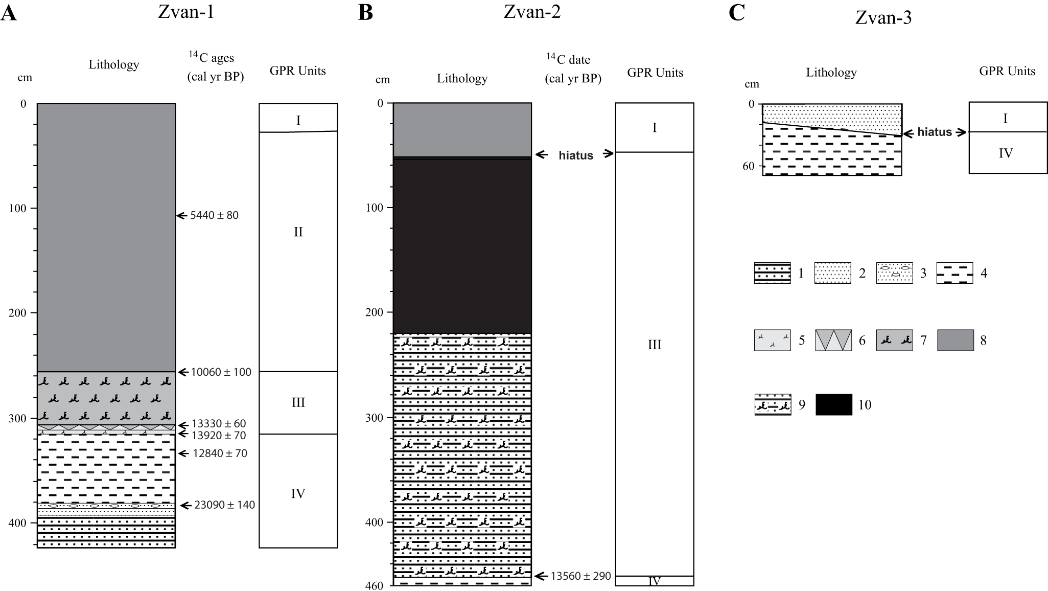
Unit IV sediments are present only in the Zvan-1 and Zvan-3 cores (Figs. 3 and 4). In the Zvan-1 core, these sediments are detected between 315 and 424 cm. They can be interpreted as shallow-water sand sediments with some traces of wave erosion and, partly, as relatively deep-water silt and clay sediments with rhythmic lamination (Fig. 4A). In core Zvan-3, the Unit IV sediments are represented by sandy clays, overlain by coarse-grained gravelly sands (Fig. 4C).
Lithology and stratigraphy of sediment cores collected in Lake Zvan. (A) Sediment core Zvan-1. (B) Sediment core Zvan-2. (C) Sediment core Zvan-3. 1, alternation of fine sand and silt; 2, fine sand; 3, fine sand with small pebbles; 4, planar-parallel rhythmically laminated clayey silt; 5, consolidated silt with low content of organic debris; 6, horizon associated with wave erosion; 7, laminated to consolidated silt with high content of organic debris; 8, consolidated detritus gyttja; 9, alternation of fine sand and silt with high content of organic debris; 10, peat.

The sediments of Unit III are present in the Zvan-1 and Zvan-2 cores (Figs. 3B and C and 4A and B). They are represented by two main sediment facies: relatively thin (ca. 60 cm) stratified silty layers within larger and deeper lake basins (Fig. 3E) and thicker (up to 420 cm) layers of massive sediments within small sediment pockets formed in ancient karst and/or thermokarst depressions (Fig. 3C). The Zvan-1 coring site is located within a larger basin, where the deposits of Unit III (Figs. 3B and 4A) are relatively thin and composed of silt with a high content of organic detritus. A horizon associated with wave action and slight erosion is observed at 311–306 cm depth (Fig. 4A). The Zvan-2 core was collected in a sediment pocket (Fig. 3C) with substantially thicker Unit III deposits (Figs. 3C and 4B). In the lower part of this core, they are represented by laminated silts with a high content of organic detritus pointing to accumulation in a lacustrine environment, while in the upper part, they are composed of peat, pointing to accumulation in a boggy environment.
Unit II deposits (stratified dark-brown unconsolidated gyttja) are present only in the Zvan-1 core (Fig. 4A). These sediments also demonstrate numerous traces of sagging-related deformations, but their degree is weaker than in the Unit IV deposits (Fig. 3). The thickness of the Unit II sediments in Lake Zvan depends on the depth of the initial lake subbasins (e.g., karst depressions) (Fig. 3).
Unit I deposits (stratified brown unconsolidated gyttja up to 50 cm thick) are present in the Zvan-1 and Zvan-2 cores (Figs. 3B and C and 4A and B).
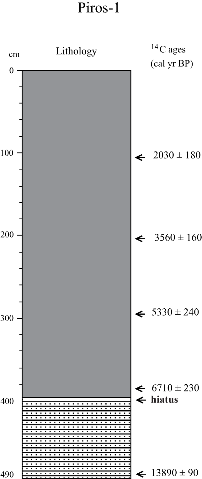
The GPR profiling of Lake Piros has revealed a simpler lake stratigraphy (Fig. 5) than in Lake Zvan, probably because this lake is deeper. Nevertheless, the radargrams clearly reflect the older deformed deposits with complex surface geometry overlain by unconsolidated lacustrine sediments. The 494-cm-long sediment core (Piros-1) was retrieved from an ancient delta (prodelta) area (Fig. 5). A visible erosional contact at 394 cm core depth separates the sandy silt from the overlying gyttja (Fig. 6).
Fragments of the ground-penetrating radar (GPR) profiles obtained in Lake Piros showing the coring positions and the main features of the sediment architecture. (A) Positions of the GPR profiles. (B) Fragment of the profile Pr1 with the core Piros-1 location. (C) Fragment of the profile Pr6 with clear indication of an irregular contact between the older deformed deposits and overlying younger sediments.

Lithology and stratigraphy of the sediment core Piros-1. The legend is shown in Figure 4 and defined in Figure 4 caption.

Chronology
To establish age–depth models for the studied cores, twelve 14C ages were obtained from both lakes including seven by the AMS method and five by the conventional method (Table 2). The reliable dates have been used to construct Bayesian age–depth models for Zvan-1 and Piros-1 (Figs. 7 and 8). The Allerød and Younger Dryas oscillations, revealed in the Zvan-1 and Piros-1 pollen records (Figs. 9 and 10), were used as tie points in the construction of the models. We used age boundaries for the oscillations (12,737 ± 31 cal yr BP for Allerød/Younger Dryas boundary and 11,535 ± 58 cal yr BP for Younger Dryas/Holocene boundary) according to Lohne et al. (Reference Lohne, Mangerud and Birks2013) and Mangerud (Reference Mangerud2021). The age–depth calculation was performed using the rBacon library (Blaauw and Christen Reference Blaauw and Christen2011; Blaauw et al. Reference Blaauw, Christen, Vazquez, Belding, Theiler, Gough and Karney2020) for R (McKay et al. Reference McKay, Emile‐Geay and Khider2021).
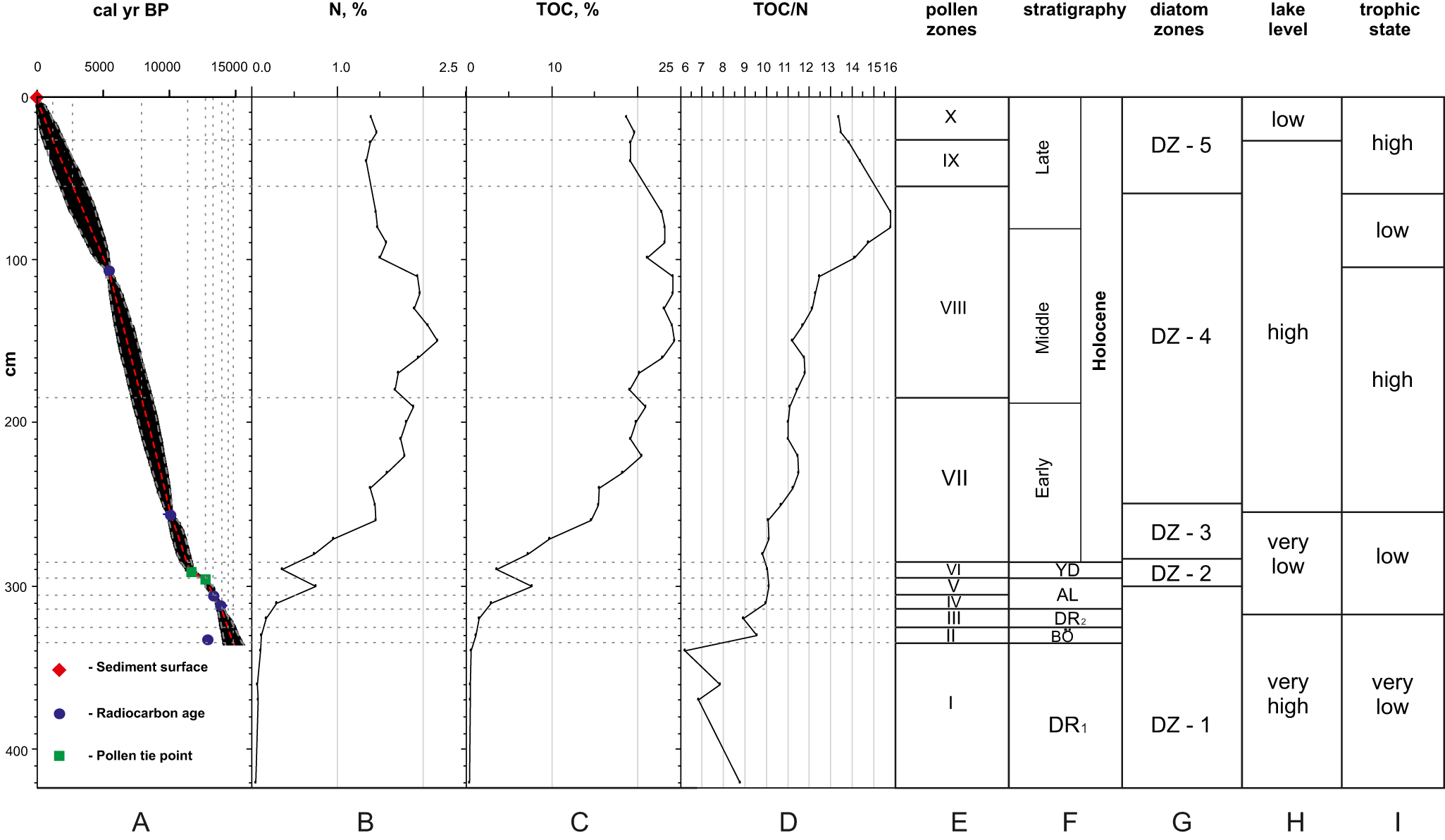
Sediment core Zvan-1 chronology, stratigraphy, organic geochemistry, and paleoenvironmental interpretation. (A) Age–depth model; (B) total nitrogen (TN); (C) total organic carbon (TOC) (D) TOC:TN ratio (TOC/N); (E) pollen zones; (F) stratigraphy; (G) diatom zones (DZ); (H) lake level; and (I) trophic state. YD, Younger Dryas; AL, Allerød; BO, Bølling; Dr1, Oldest Dryas; Dr2, Older Dryas.

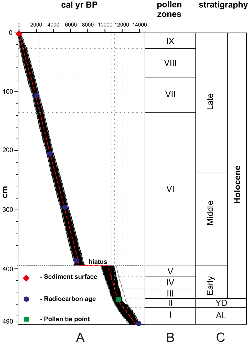
Sediment core Piros-1 chronology and stratigraphy. (A) Age–depth model; (B) pollen zones; and (C) stratigraphy. YD, Younger Dryas; AL, Allerød.

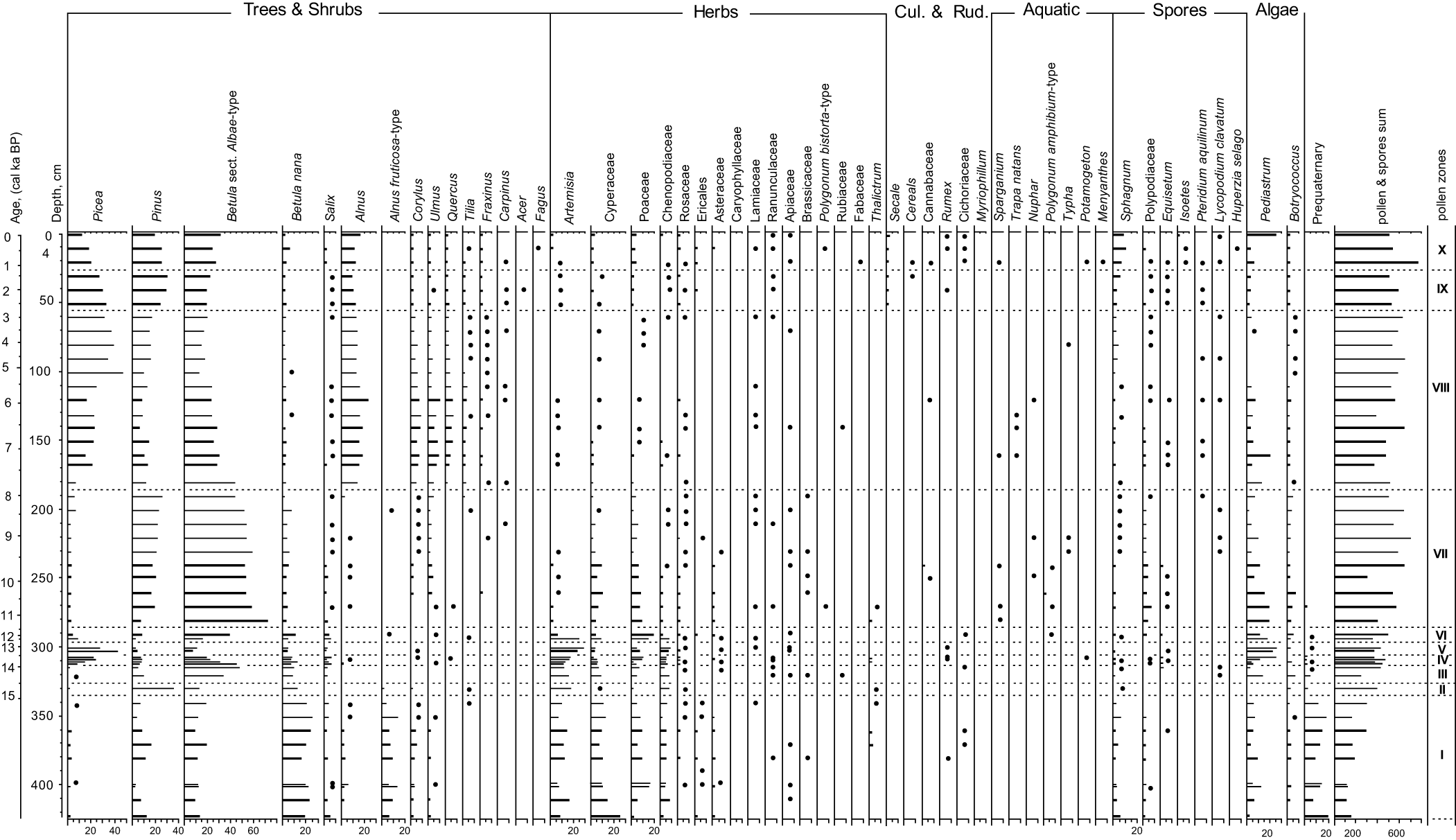
Percentage pollen diagram of the core Zvan-1. PZ, pollen zone.

Percentage pollen diagram of the core Piros-1. PZ, pollen zone.

14C dates from the studied sediment cores.

a Ages marked with asterisks (*) were obtained via the conventional 14C method.
Zvan-1 core chronology
Six 14C dates have been obtained from the sedimentary sequence Zvan-1 (Table 2). Unfortunately, the dates from the lowest 65 cm are not reliable. The 14C date 23,090 ± 140 cal yr BP from 382–381 cm core depth (Figs. 4A and 7; Table 2) corresponds to the so-called Middle Valdai mega-interstadial (Arslanov, Reference Arslanov1993) and clearly contradicts the regional reconstructions of the LGM ice extent (Hughes et al., Reference Hughes, Gyllencreutz, Lohne, Mangerud and Svendsen2016; Gorlach et al., Reference Gorlach, Hang and Kalm2017; Rinterknecht et al., Reference Rinterknecht, Hang, Gorlach, Kohv, Kalla, Kalm and Subetto2018). We suppose that the organic material was mostly redeposited from older sediments into the lake basin during the late glacial and reject this date from the age modeling. Another 14C date, 12,840 ± 70 cal yr BP, from 332–331 cm core depth (Fig. 4A; Table 2), contradicts the pollen stratigraphy (Fig. 9), which clearly points to Allerød and Younger Dryas intervals (305–295 and 295–285 cm, correspondingly) above this date and with the two 14C dates: 13,330 ± 60 and 13,920 ± 70 cal yr BP (Fig. 4A; Table 2) from the upper part of the core as well. Therefore, we also reject this date from the age modeling. For our age–depth model for the Zvan-1 core (Fig. 7), we adapted Allerød/Younger Dryas and Younger Dryas/Holocene boundaries by Lohne et al. (Reference Lohne, Mangerud and Birks2013) and Mangerud (Reference Mangerud2021).
Piros-1 core chronology
Five 14C dates ranging from 13,900 to 2000 cal yr BP (Figs. 6 and 8; Table 2) have been obtained from the sedimentary sequence Piros-1. A sharp lithological transition from sandy silt to organic-rich gyttja at 394 cm core depth (Fig. 6) accompanied by clear traces of erosion and abrupt changes in pollen assemblages (Fig. 10) points to a substantial hiatus in the sediment accumulation at the core location. Pollen-based regional stratigraphy (e.g., Khotinsky, Reference Khotinsky and O.M1987; Khotinsky and Klimanov, Reference Khotinsky and Klimanov1997; Arslanov et al., Reference Arslanov, Savelieva, Gey, Klimanov, Chernov, Chernova and Kuzmin1999; Tarasov et al., Reference Tarasov, Savelieva, Long and Leipe2019 and references therein) and a 14C date above the erosional boundary demarcate the hiatus between ca. 10,300 and 7000 cal ka BP. This hiatus and pollen-based Allerød/Younger Dryas and Younger Dryas/Holocene boundaries were also taken into consideration for the construction of the age–depth model for the Piros-1 core (Fig. 8).
Pollen stratigraphy
Sediment Core Zvan-1
A total of 49 samples from the sediment core Zvan-1 were analyzed for pollen, spores, and green algae (Fig. 9). All palynomorphs found were well preserved. Mineralized pre-Quaternary spores and pollen (up to 20%) were observed between 424 and 270 cm core depths. The revealed pollen assemblages were subdivided into 10 pollen zones (PZ) and are presented in Table 3.
Main pollen zones (PZ) of the Zvan-1 sediment core.

Sediment Core Piros-1
A total of 59 samples from the sediment core Piros-1 were analyzed for pollen, spores, and green algae (Pediastrum). The revealed pollen assemblages were subdivided into nine PZs (Fig. 10) and are presented in Table 4.
Main pollen zones (PZ) of the Piros-1 sediment core.

Diatom stratigraphy
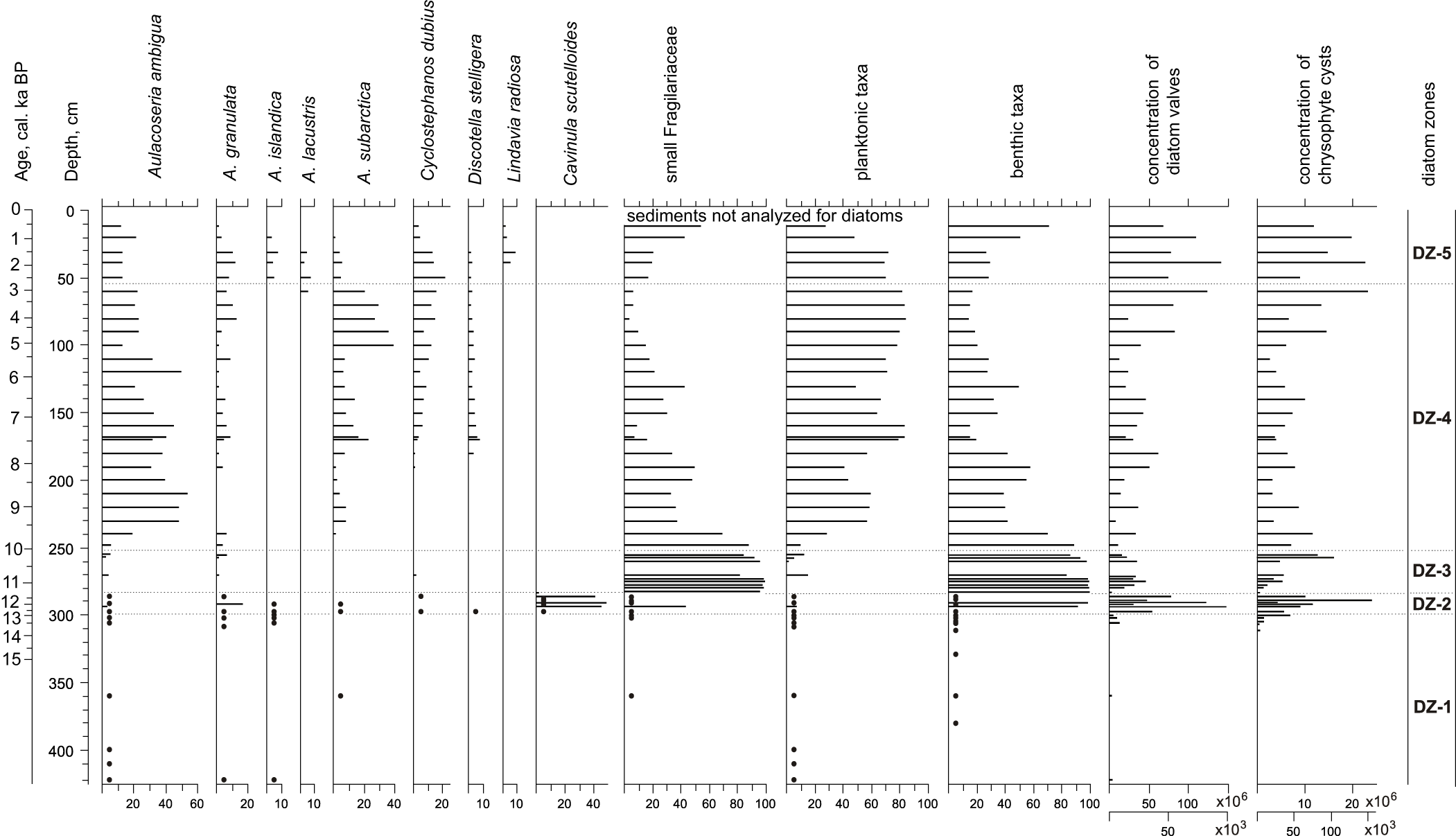
A total of 53 samples from the Zvan-1 core sediments were analyzed for diatoms and siliceous microfossils (Fig. 11). The revealed diatom assemblages were subdivided into five diatom zones (DZ) and are presented in Table 5. The upper 9 cm of the core was not studied for diatoms because of insufficient core sediments for all kinds of analyses.
Relative abundances (in percentages) of the main diatom taxa and ecological groups, and concentration of diatom valves and chrysophyte cysts (gray bars, thousands; black bars, millions per 1 g of dry sediment) in Lake Zvan. Black dots indicate presence of taxa in the diatom assemblages where diatom counts were too low to calculate reliable percentages. DZ, diatom zone.

Main diatom zones (DZ), total organic carbon (TOC), and total nitrogen (TN) content of the Zvan-1 sediment core.

TOC and TN content
Measurements of TOC and TN were carried out for the Zvan-1 sediment core (Fig. 7). In the lower part of the core (423–340 cm), TOC and TN are extremely low (0.5–0.6% and 0.05–0.1%, respectively). Large increases in both values are observed between 340 and 300 cm core depths (with TOC up to 7.7% and TN up to 0.8%), followed by a substantial decrease at 290 cm. Above 290 cm, the values further increase, reaching a maximum between 170 and 100 cm core depths (up to 24.3% for TOC and 2.2% for TN). The TOC:TN ratio shows a different trend (Fig. 7); although increasing gradually, it reaches a maximum (15.8) between 110 and 20 cm core depths.
Interpretations and discussion
Oldest Dryas
The oldest sediments were found in the Zvan-1 core. It is difficult to estimate the age of the bottom part because of a lack of reliable 14C dates in the lower part of the core. However, taking into consideration the existing reconstructions of the SIS ice-marginal zone during the LGM (e.g., Hughes et al., Reference Hughes, Gyllencreutz, Lohne, Mangerud and Svendsen2016; Gorlach et al., Reference Gorlach, Hang and Kalm2017; Gromig et al., Reference Gromig, Wagner, Wennrich, Fedorov, Savelieva, Lebas and Krastel2019 and references therein), we assume that the lacustrine accumulation in the initial lake basin started shortly after the deglaciation of the area, which may have occurred by 17 cal ka BP or even earlier. Thus, PZ I sediments (Fig. 9) were accumulated mostly during the Oldest Dryas, between the start of the deglaciation and 14.9 cal ka BP.
Pollen spectra document that open tundra-steppe communities with Artemisia, Cyperaceae, Poaceae, Chenopodiaceae (= Amaranthaceae), Asteraceae, and Rosaceae dominate in the study area. However, shrubs such as dwarf birches, alders, and willows were also common, indicating forest-tundra vegetation. Relatively high amounts of Betula sect. Albae, Pinus, and Corylus pollen might have a long-distant (wind-transported) origin, while very high amounts (up to 20%) of mineralized pre-Quaternary palynomorphs point to a reworked origin for these tree pollen taxa. Generally, the pollen assemblages (PZ I of Fig. 9) document harsh climatic conditions in the study area and correlate well with the Oldest Dryas records from northeastern Russia (e.g., Khotinsky, Reference Khotinsky and O.M1987; Khotinsky and Klimanov, Reference Khotinsky and Klimanov1997 and references therein).
The relatively numerous remains of green alga colonies (Pediastrum and Botryococcus) reflect the rather shallow-water habitats in the initial lake basin. The very low abundances of diatoms and cysts of chrysophytes in the sediments (Fig. 11) indicate active sedimentation processes in this initial basin lake.
Bølling
Contents of Pinus pollen substantially increase between ca. 14.9 and 14.4 cal ka BP (PZ II of Fig. 9), reflecting the possible presence of Scots pine in the lake catchment and warmer climate conditions during this interval. The revealed climate amelioration coincides well with the Bølling interstadial (ca. 14.7–14.1 cal ka BP). However, rather high percentages of herbs (especially Artemisia and Amaranthaceae) and a substantial decrease in the occurrence of shrubs point to relatively cool and dry climate conditions in the lake vicinity. Nevertheless, the disappearance of pre-Quaternary pollen and spores in the PZ II sediments suggest more stable soil conditions and denser vegetation cover in the lake catchment. The TOC and TN contents are slightly higher in the PZ II sediments compared with the extremely low contents in PZ I (Fig. 7). The increased C:N ratio (Fig. 7) indicates more allochthonous organic matter input, also pointing to warmer climate conditions. Pediastrum colonies are also substantially low in the PZ II sediments, which most likely reflects a higher lake level.
Older Dryas
PZ III pollen assemblages (Fig. 9) record the disappearance of Scots pine stands in the study area, which was covered mostly by open birch forests and steppe-like communities. This short-term cold stage can be correlated with the Older Dryas climate oscillation that occurred between the Bølling and Allerød interstadials about 14 ka BP. Its duration is not well defined; the estimates vary from 200 to 400 years. The increased amount of Pediastrum remains in the PZ III sediments points to numerous shallow-water habitats in the lake basin, presumably due to a lowering of water level in the lake at this time.
Allerød
A marked increase in Picea pollen percentages in the sediments is dated to ca. 13.9 cal ka BP (PZ IV of Fig. 9), documenting the appearance of spruce in the local vegetation and reflecting a substantial increase in summer temperatures and humidity. Percentages of Picea further increase in PZ V sediments (ca. 13.30–12.73 cal ka BP) and remain relatively high in the lower part of PZ VI until ca. 12.5 cal ka BP. The presence of spruce in the vegetation is associated with a continental climate with warm summers and moist soils (Giesecke and Bennett, Reference Giesecke and Bennett2004). The peak in Picea pollen percentages in the Zvan-1 core (ca. 13.30–12.73 cal ka BP) is simultaneous with the peaks in TOC and TN (Fig. 7), which also point to warmer climate conditions at this time. The bottom sediments of the Piros-1 core (PZ I of Fig. 10, ca. 14.0–12.1 cal ka BP) also have a high Picea pollen presence, suggesting the widespread distribution of spruce forests in the study area. The dominance of spruce in the local vegetation between ca. 14.0 and 12.5 cal ka BP) coincides well with the Allerød interstadial, which occurred from ca. 13.9–12.7 cal ka BP.
Generally, the marked increase of Picea pollen percentages in the Allerød sediments (the so-called lower peak of spruce), reflecting the appearance of spruce, has previously been reported in the central and northwestern parts of the East European platform (e.g., Khotinsky, Reference Khotinsky and O.M1987; Khotinsky and Klimanov, Reference Khotinsky and Klimanov1997; Kremenetski et al., Reference Kremenetski, Borisova and Zelikson2000; Davydova et al., Reference Davydova, Subetto, Khomutova and Sapelko2001; Latalowa and van der Knaap, Reference Latałowa and van der Knaap2006; Novenko et al., Reference Novenko, Volkova, Nosova and Zuganova2009; Savelieva et al., Reference Savelieva, Andreev, Gromig, Subetto, Fedorov, Wennrich and Wagner2019; Tarasov et al., Reference Tarasov, Savelieva, Long and Leipe2019 and references therein). However, the appearance of spruce in the Valdai Highlands was not properly dated. For example, Wohlfarth et al. (Reference Wohlfarth, Lacourse, Bennike, Subetto, Filimonova, Tarasov and Sapelko2007), based on the record from Lake Terebenskoye (approximately 40 km to the west of Lake Zvan; Fig. 1), suggest that the first appearance of spruce in the study area occurred only at 12 cal ka BP. From our pollen records (Figs. 9 and 10), the first appearance of spruce in the Valdai Highlands occurs around 14.0–13.9 cal ka BP, which is much earlier than previous estimations for the Valdai Highlands and ca. 600–800 years earlier than in the Lake Ladoga area (Savelieva et al., Reference Savelieva, Andreev, Gromig, Subetto, Fedorov, Wennrich and Wagner2019).
Although spruce was a dominant forest taxon during the Allerød, birch was also a common tree in the local forests. High levels of herb pollen in the lake sediments suggest that open steppe- and tundra-like vegetation dominated by Poaceae, Cyperaceae, Artemisia, Amaranthaceae, Rosaceae, and Thalictrum was also broadly distributed in the area. Pre-Quaternary palynomorphs almost disappeared from the sediments, pointing to a substantial decrease in the erosional processes and denser vegetation cover. The increased C:N ratio also indicates more allochthonous organic matter input (Fig. 7). Colonies of the green alga Pediastrum significantly increase in the Allerød sediments compared with the Older Dryas sediments, reflecting the presence of numerous shallow-water habitats in the lake basin and warmer conditions.
Younger Dryas
A marked decrease in Picea pollen percentages in the Zvan-1 sediments (PZ VI of Fig. 9) after ca. 12.73 cal ka BP and around 12.6 cal ka BP in the Piros-1 sediments (PZ II of Fig. 10) reflect the disappearance of spruce from the local vegetation as a result of a substantial climate deterioration. Birch forests and open landscapes with dwarf shrubs, wormwoods, grasses, and sedges dominated the study area between ca. 12.7 and 11.5 cal ka BP. This cold and dry interval coincides well with the Younger Dryas stadial (Lohne et al., Reference Lohne, Mangerud and Birks2013; Mangerud, Reference Mangerud2021).
Pollen percentages of tree birches and shrubs gradually increase in both sediment cores, while pollen of herbs (especially Artemisia and Amaranthaceae) decrease upward to the onset of the Holocene, reflecting a gradual climate amelioration (Figs. 9 and 10).
Early Holocene
The pollen assemblages in the sediments accumulated during the Early Holocene (PZ VII of Fig. 9 and PZ III and PZ V of Fig. 10) reflect a further development of the Scots pine and birch forests in the area, while typical late glacial communities dominated by Artemisia, Amaranthaceae, Rosaceae, and other herbs disappeared from the vegetation cover. Pre-Quaternary palynomorphs are almost absent in the Holocene sediments, reflecting that active erosion processes have stopped. More stable soil conditions and denser vegetation around the lakes resulted in a further increase in C and N content and the C:N ratio indicates more allochthonous organic matter input in the lake sediments (Fig. 7). The presence of aquatic pollen taxa (Nuphar, Sparganium, Myriophyllum, Polygonum amphibium, and Typha) in the Early Holocene sediments suggests more warm and stable aquatic environments in the lake. Thus, the Early Holocene pollen assemblages reflect the transition to the interglacial climatic conditions. Scots pine and birch were the dominant trees in the study area until ca. 8 cal ka BP. The first broadleaved taxa—elm and hazel (Corylus)—probably arrived in the Lake Zvan catchment by around 10.3 cal ka BP (PZ VII of Fig. 9). Elm is a thermophilic broadleaved tree species that began its expansion to the northwest Russian Plain after the last glaciation, when the temperature and moisture increased sufficiently to allow the northward migration of the thermophilic broadleaved trees from their southern refugia.
Mid-Holocene
During the Mid-Holocene (after 8 cal ka BP), alder and spruce, as well as thermophilic broadleaved trees including oak (Quercus), elm (Ulmus), hazel (Corylus), lime (Tilia), and ash (Fraxinus), became more common in the area, which was dominated by forests with spruce, Scots pine, birch, alder, and other broadleaved taxa. According to the pollen assemblages, the presence of the broadleaved taxa in the local vegetation was the highest between ca. 8 and 4 cal ka BP (PZ VIII of Fig. 9 and PZ VI of Fig. 10) reflecting the warmest climate conditions (Holocene thermal maximum) in the study area. Pollen of water caltrop (Trapa natans), a taxon especially indicative of relatively warm water conditions, was found in Lake Zvan sediments (PZ VIII of Fig. 9), supporting the inference of the warmest climate during this time. TOC and TN reach their maximum values in the sediments accumulated during this time interval (Fig. 7), reflecting the highest bioproductivity in the lakes and thus confirming the warmest climate conditions during this Holocene thermal maximum. Low amounts of green alga colonies (Pediastrum and Botryococcus) in the Zvan sediments accumulated between ca. 8 and 4 cal ka BP (PZ VII of Fig. 9) probably reflect a higher lake level in Lake Zvan. The simultaneous slight increase in Sphagnum spore content may reflect the start of paludification in the lake’s vicinity because of the higher lake level.
Late Holocene
Abundance of spruce and Scots pine in the local vegetation increased during the Late Holocene after 4 cal ka BP, while broadleaved taxa decreased. The study area was mostly dominated by spruce and mixed pine–birch–spruce forests with some broadleaved taxa. Picea pollen percentages reach their highest values in the Late Holocene sediments (PZ VIII of Fig. 9 and PZ VI of Fig. 10) and correlate well with the so-called upper maximum of spruce during the Subboreal period according to Khotinsky (Reference Khotinsky and O.M1987). A further increase in Sphagnum spore content reflects wetter environments around Lake Zvan compared with the Middle and Early Holocene. These environmental changes point to a cooler and wetter climate in the study area.
The pollen assemblages from the sediments accumulated after ca. 2.5 cal ka BP (PZ IX and X of Fig. 9 and PZ VII–IX of Fig. 10) reflect local forests with spruce, Scots pine, birch, and alder dominating the study area. The pollen of cultivated cereals (rye (Secale) and probably wheat (Triticum)) were found in PZ IX (Fig. 9) and PZ VII (Fig. 10) dating from around 2.5 cal ka BP. We assume that they document the beginning of agricultural activity in the lakes’ catchments. Generally, our new pollen records confirm previous evidence of agricultural land use in the Valdai region since ca. 2 cal ka (Novenko et al., Reference Novenko, Volkova, Nosova and Zuganova2009; Tarasov et al., Reference Tarasov, Savelieva, Long and Leipe2019). However, it is not completely clear whether the agricultural activity in the catchments of Lake Zvan and Lake Piros started slightly earlier than in other parts of the Valdai Highlands and thus exemplifies differing rates of human colonization and migration processes in the different parts of the Valdai region, or whether it is just dating errors in previous studies and our lakes.
The upper PZs (PZ IX and X of Fig. 9 and PZ VII–IX of Fig. 10) also demonstrate a higher abundance of herb pollen such as grasses, sedges, and ruderals (e.g., Rumex, Plantago, Urtica, Artemisia, Asteraceae, Rosaceae), reflecting the active use of land around the lakes for the cultivation of crops and depasturing. The further decrease of broadleaved pollen taxa such as Quercus could also be a result not only of climate deterioration but also of human activity due to the selected use of trees.
The uppermost pollen spectra from the Piros-1 sediment core (PZ IX of Fig. 10) document some decrease in pollen of cultivated cereals and ruderals, which probably reflects a decline in agricultural activity during the last century.
Lake histories and landscape dynamics
Our study reveals that deposits of the GPR Unit IV (Fig. 4) in Lake Zvan were accumulated during the Oldest Drays, Bølling, and Older Drays, between ca. 17 and 14 cal ka BP. These deposits are well presented in the Zvan-1 core (Fig. 4A). Lithological features of the lower part of the core (424–381 cm core depth; planar-parallel and cross-laminated medium to coarse-grained sands with occasional inclusions of small pebbles) indicate that the initial stages of the lake formation were associated with substantial water and sediment input. The upper part of these deposits (381–315 cm core depth; Fig. 4A), represented by planar-parallel rhythmically laminated clayey silts, reflect sedimentation in a relatively deep cold-water aquatic environment with pronounced differentiation in seasonal conditions. Extremely low concentrations of diatoms and chrysophyte cysts (Fig. 11) in the Unit IV sediments suggest unfavorable conditions in the aquatic ecosystem resulting in their low productivity. Another important factor influencing microfossil concentrations is the sedimentation rate, as high amounts of mineral particles coming from the catchment cause low diatom concentrations. Such conditions are typical for proglacial lakes or lakes in areas with large volumes of dead ice. However, we can exclude sedimentation in a proglacial lake in front of the ice sheet, as the formation of the GPR Unit IV continued until the Allerød warming (approximately 14 cal ka BP), when the ice margin is reconstructed as being much farther to the north-northwest (Hughes et al., Reference Hughes, Gyllencreutz, Lohne, Mangerud and Svendsen2016; Gorlach et al., Reference Gorlach, Hang and Kalm2017; Gromig et al., Reference Gromig, Wagner, Wennrich, Fedorov, Savelieva, Lebas and Krastel2019). Thus, we can conclude that a relatively large and deep lake dammed by dead ice masses existed in the area of the modern Lake Zvan since the ice retreated (probably already by 17 cal ka BP or even earlier) until approximately 14 cal ka BP. Deposits accumulated in the lake depression during this time were heavily deformed (Fig. 3) shortly after 14 cal ka BP due to thermokarst processes caused by the degradation of the dead ice masses.
The deep-water sediments that accumulated during the Older Dryas (Figs. 4 and 9) are overlain directly by shallow-water deposits dated to 14 cal ka BP. This fact excludes a substantial hiatus in the sediment succession and suggests that melting of the dead ice only occurred in the short time period at the very beginning of the Allerød warming. The radargrams obtained from Lake Piros (Fig. 5) display very similar features in the architecture of the older deformed and younger undeformed deposits. Therefore, the melting of dead ice recognized and dated in the Lake Zvan sediments was not a local event.
We can state that at approximately 14 cal ka BP, the climatic conditions in the Valdai Highlands became favorable for the very rapid degradation of the surviving dead ice masses, which led to the drainage of the ice-dammed lakes system, the release of a huge freshwater volume, and radical changes in the surrounding landscapes. These processes could have led to the reactivation of the karst processes in the Valdai Highlands due to the large amounts of meltwater causing aggressive dissolution of carbonate rocks.
Deformations of the GPR Unit IV deposits in Lake Zvan (Figs. 2 and 3) and the analogous sediments in Lake Piros (Fig. 5) can easily be explained by the degradation of dead ice. However, the sagging deformations (Fig. 3) observed in the younger sediments upward to the Late Holocene cannot be explained by the degradation of dead ice during the late glacial. Such deformations in the younger sediments suggest that karst processes played an important role in the formation of the modern lake basin. There are a number of lines of evidence for the substantial shallowing and partial drying out of the lake basin during the subsequent stage. The active erosional processes are evidenced by the truncation at the top of the GPR Unit IV in Lake Zvan (Figs. 2–4) and analogous deposits of Lake Piros (Figs. 5 and 6). A horizon associated with wave erosion is observed in core Zvan-1 (Fig. 4A). The sedimentary structure reflects the sharp changes in the deposition settings as well.
In core Zvan-1 (Fig. 4A), the sediments that accumulated during the Allerød, Younger Dryas, and partly during the Early Holocene are represented by a ca. 50-cm-thick massive silt with a high content of organic debris without any evidence of possible hiatuses. This layer suggests extremely low sedimentation rates in shallow waters and accumulation of reworked organic debris. In core Zvan-2, deposits of this age are represented by peat (Figs. 3 and 4B), again indicating a shallow-water environment, alongside active eutrophic processes in the lake basin. The high content of green algae remains (mostly Pediastrum) in these sediments (Fig. 9), as well as in the Allerød sediments in the Piros-1 core (Fig. 10), also reflect shallow-water habitats in both lakes.
The massive silt with a high content of organic debris in the Zvan-1 core (Fig. 4A) corresponds to the diatom zones DZ-2 and DZ-3 (Fig. 11). The increase in the concentration of siliceous microfossils (DZ-2) indicates a change in sedimentation conditions, in particular, a substantial reduction in the amount of allochthonous mineral particles coming into the lake basin, resulting in more favorable conditions for the aquatic biota (particularly diatoms and chrysophytes). The overwhelming dominance of the benthic diatom Cavinula scutelloides clearly indicates the shallowing of the lake, with a shift in the environment to more alkaline conditions and increased concentrations of essential nutrients.
A further increase in the productivity of the ecosystem resulted in increased abundances of both groups of siliceous microfossils to several tens of millions (DZ-3). The dominance of benthic Staurosira construens, Staurosira venter, and Staurosirella pinnata often marks transitional conditions with a dynamic and unstable environment. However, their predominance in DZ-3 (Fig. 11) might also indicate shallow depths, as well as accessibility of substrate for colonization, in particular, macrophytes. These species have been observed among the dominating taxa in Lake Valdai since the Younger Dryas (Davydova et al., Reference Davydova, Kabailene, Raukas and Yakushko1992, Reference Davydova, Subetto, Khomutova and Sapelko2001).
The Lake Zvan sediment record reveals the dead ice degradation and drainage of the initial large and deep lake at the beginning of the Allerød. These processes were accompanied by extremely slow sedimentation in the shallow-water environments (Figs. 3B and 4A), peat formation in the swampy areas (Figs. 3C and 4B), and partial erosion of the late glacial sediments (Figs. 3D and 4C) during the end of the late glacial to the Early Holocene. Organic-rich gyttja started to accumulate in the lake after ca. 10 cal ka BP (Fig. 4A), reflecting lake-level rise and the formation of the lake basin similar to the modern one.
Unlike Lake Zvan, two large lakes (Piros and Valdai) show completely different dynamics of lake level during the Early Holocene. In core Piros-1 from Lake Piros, we observe a hiatus between ca. 10.3 and 7.0 cal ka BP (Fig. 6). This hiatus coincides with a hiatus revealed in the Lake Valdai sediment sequence between ca. 10.5 and 8.0 cal ka BP (Davydova et al., Reference Davydova, Kabailene, Raukas and Yakushko1992, Reference Davydova, Subetto, Khomutova and Sapelko2001). This low lake-level stand and/or hiatus is not evident in the Early Holocene sediments of smaller lakes located in the same area (Fig. 1), such as Lake Zvan (this study) and Lake Terebenskoye (Wohlfarth et al., Reference Wohlfarth, Lacourse, Bennike, Subetto, Filimonova, Tarasov and Sapelko2007; Subetto, Reference Subetto2009). Taking into consideration that small lakes, normally, respond more quickly and more explicitly to temperature and water supply changes, we suggest that the long-lasting low lake-level stand in Lake Piros and Lake Valdai is not directly related to climate conditions. Instead, karst processes resulting in lake drainage could be one possible explanation for the lake level lowering.
In the Zvan-1 core, the onset of consolidated gyttja accumulation occurred shortly after ca. 10.12 cal ka BP (Fig. 4A). This correlates well with previous studies in northwestern Russia (e.g., Wohlfarth et al., Reference Wohlfarth, Lacourse, Bennike, Subetto, Filimonova, Tarasov and Sapelko2007; Subetto, Reference Subetto2009). Accumulation of unconsolidated organic sediments (gyttja) is indicative of bioproductivity increase as well as lake-level rise, because gyttja is not formed in very shallow waters.
The composition of the diatom assemblages accumulated between ca. 9.9 and 3.0 cal ka BP (DZ-4 of Fig. 11) suggests relatively warm climate conditions, resulting in the increase of the trophic state of Lake Svan, with a deeper aquatic environment indicated by the dominance of planktonic eutrophic species. Changes in the diatom assemblages in the upper part of DZ-4 (Fig. 11) reflect a trend toward the dominance of planktonic taxa, which might be a result of the increasing water level. The gradually increasing content of Sphagnum spores in the upper pollen zones (Fig. 9) starting after 5 cal ka BP most likely reflects paludification in the surrounding areas due to the gradual increase in lake level. This inference is supported by the absence of Pediastrum remains in the upper part of PZ VIII (Fig. 9), as this green alga prefers relatively shallow water, and its disappearance from the lake sediments between ca. 5 and 3 cal ka BP points to a deeper lake level during this interval.
The general increase of planktonic diatoms up-core most likely reflects an increasing lake level. The dominance of oligo-mesotrophic Aulacoseira subarctica in the upper part of DZ-4 (Fig. 11) indicates a slight decrease in the trophic state of the lake. This is also reflected by changes in the C:N ratio, which reaches its maximum in this interval (Fig. 7), indicating a reduction in autochthonous organic matter.
Diatom assemblages of the uppermost diatom zone of the Zvan-1 core (DZ-5 of Fig. 11) accumulated during the last 3 cal ka BP and reflect possible changes in lake level and trophic state. Higher proportions of planktonic taxa (Aulacoseira ambigua, Aulacoseira granulata, Cyclostephanos dubius) in the sediments accumulated between 3 and 1.4 cal ka BP indicate a higher trophic state of the lake and, apparently, a deep-water environment, as the dominance of these taxa points to higher contents of nutrients, especially biogenic silica. The substantial increase in diatom concentration also indicates an increase in lake bioproductivity. Decreasing amounts of benthic diatoms suggest a lower substrate availability for diatom colonization as the lake level rose. Water transparency could also decrease because of excessive phytoplankton growth.
The diatom assemblages from the sediments accumulated after 1.4 cal ka BP (the uppermost 30 cm of DZ-5; Fig. 11) demonstrate a decrease in the ratio of planktonic to benthic diatoms. These changes may indicate the lowering of the lake level due to infilling of the lake. These changes to lake status are probably interconnected with the intensification of agricultural land use as revealed in the uppermost pollen zones (PZ IX and X of Fig. 9). This also coincides with the large increase in Sphagnum spores, reflecting paludification processes, which could also be connected with human activity in the lake catchment.
Conclusions
The multiproxy studies of sediment cores collected from two lakes in the eastern part of the Valdai Highlands provide a reliable basis for reconstructions of the climate, landscape, and lacustrine system dynamics after ca. 17 cal ka BP. The relatively small hydrologic and ecological systems of the studied lakes are quite sensitive to the regional climate and environmental changes as well as to local human activity.
After the ice sheet retreated from the area after ca. 17 cal ka BP and before the beginning of Allerød warming (∼14 cal ka BP), the Valdai Highlands were dominated by dead ice and ice-dammed cold, deep lakes. Abrupt environmental changes occurred shortly after 14 cal ka BP. Most of the dead ice in the Valdai Highlands melted, causing the drainage of the huge ice-dammed lakes and the release of vast landmasses. The appearance of spruce in the local forests at this time marks substantial changes in the vegetation cover and climate conditions. This period can also possibly be associated with reactivation of karst processes in the Valdai Highlands. In the Early Holocene, around 10 cal ka BP, the establishment of the modern types of landscape and lake systems took place in the Valdai Highlands, which is consistent with the onset of organic gyttja sedimentation.
The last ∼2500 years in the Valdai Highlands have been characterized by the onset of agricultural land use; a simultaneous drop in temperature; and interconnected environmental consequences such as lake eutrophication, paludification of the catchment areas, and weakening of karst processes.
Acknowledgments
Part of the fieldwork was carried out with the use of the GPR instrument provided by the St. Petersburg State University Center for Geo-Environmental Research and Modeling (GEOMODEL). Research of AL contributes to the State Research Program of the Institute of Limnology, RAS–SPC RAS. The authors are grateful to the Centre of Accelerator Mass Spectrometry at the University of Cologne and personally to Janet Rethemeyer for the dating of lake sediments. The authors are also very grateful to Lewis Owen, Peter Langdon, and two anonymous reviewers for their valuable suggestions, recommendations, and edits, which helped to improve the initial manuscript. Special thanks to Cathy Jenks for English proofreading the final version of the manuscript.
Funding
The fieldwork was funded by the Russian Foundation for Basic Research (RFBR grant 15-05-02584). The work of GF supported by the Republic of Armenia Ministry of Education, Science, Culture and Sports (project–23IRF-1E02).