

Cities have their own distinctive identities which they impose on their indigenous and migrant populations, who are influenced by each city's character and customs, refined by its culture and bound by its norms. The city is not in the habit of changing its particularities, except through urbanization in step with the latest scientific and technological developments, and its administration evolves through the application of local and universal managerial programmes propagated by international organizations or through relations with developed cities in other States in the form of economic, scientific or cultural exchanges or through agreements establishing sister cities, etc.
The most influential factor in the life of major cities like Damascus is their population, consisting of their residents and permanent and temporary immigrants, the intermixture of which gives rise to a pluralistic urban society governed by a local civic administration that imposes the city's identity on all of them. The ongoing influx of migrants makes it difficult for these cities to provide housing and services and even more difficult for the constant waves of migrants to acclimatize to the groups that have been socially, culturally and economically long-established in the city. The city therefore suffers from phenomena that fragilize its basic planning and its developmental, socioeconomic and environmental structures. This fragility is manifested in the form of social instability, gains that can be lost at any moment, dismal future prospects, disquiet and difficulties in meeting the requirements needed to ensure that all members of society enjoy a decent life. The populace are in a fragile condition when they are living on the poverty line and are at risk of falling below it in the event of any fluctuations in their socioeconomic circumstances. They are particularly vulnerable to negative events and may be treated in an inappropriate manner by governmental and social institutions. Symptoms of social fragility are revealed by a high level of unsatisfied basic needs, widespread poverty, inequality and deprivation of services, resources and development opportunities.Footnote 1 Some groups adopt the principle of social solidarity within closed communities as a compensatory means to regain security by making individual conscience subservient to tribal, religious, ethnic or regional factionalism.Footnote 2
This Opinion Note will illustrate the latent fragility of community security in the major Syrian cities by analyzing a sample from Damascus and its environs. This analysis will show the fragility resulting from the disparate structures of the closed groups in the neighbourhoods and districts constituting the city of Damascus and its hinterland, which proved to be flashpoints for the crisis. The paper will also explain how this situation still poses a threat, notwithstanding indications of an end to the armed conflict, since those districts were, and still are, suffering from a lack of confidence in the “community security” that the administrative system should provide in the city and all its residential districts, neighbourhoods and agglomerations by nurturing a feeling of belonging, continuity, stability and permanence. Due to administrative neglect and a failure to establish socioeconomic programmes affirming the identity of the local administrations and reducing the disparities between districts, all those districts are endeavouring, through cohesion and homogeneity, to strengthen the concepts of “security” (as a situation in which a person is not in danger or under threat and feels free from fear) and “safety” (as a state of peace of mind in regard to self and household in a tribal environment that dispels any feeling of danger). By distancing itself in this way from the civic administration, any cohesive and closed district can achieve a form of “social stability” for itself at the expense of the stability of the city's wider primal society, which feels threatened by the presence of disparate groups with their own particularities, links, security, safety and means of cohesion. In consequence, society in this context can be more accurately portrayed as a set of spatial zones exhibiting cohesive socioeconomic particularities and prepared to defend themselves against any external aggressor because of their weakened sense of direct belonging to the wider primal society due to its inadequate interaction with them or the small extent to which they are influenced by it.
This Opinion Note will also endeavour to explain the need for local administrations and competent authorities to play their role by taking developmental and planning measures to reduce disparities and promote cultural open-mindedness between these communities and the wider Damascene urban society. After this introduction, the paper will focus on the overall spatial characterization of Damascus and its environs, and will then provide a commentary on the cohesive but disparate human agglomerations in the city and its hinterland with an analytical generic description of the demographic factor, leading to the question of community security and its relation to demographic dissimilarities. This will be followed by an analytical description of urban planning developments in Damascus and its environs prior to 2010 and during the 2011–18 crisis, in order to clarify the manner in which planning problems and delays in resolving them fragilized community security as a result of the proliferation of cohesive closed communities seeking to ensure their own security and safety outside the control of local administrative authorities. The paper will then analyze the particularities of rural and urban areas during the ongoing crisis in 2018 and thereafter, as well as the latent fragility of the security situation in Damascus and its environs. Finally, the paper will assess the planning, social, developmental and security situation by projecting maps of three specific determinants on a map of the armed conflict in Damascus and its environs and highlighting the inevitability of fragility in the event of ongoing poverty, faulty city planning and informal settlements as an example of the fragile community security situation from which all major and intermediate Syrian cities are suffering.
The city of Damascus and its environs
Damascus, being the country's capital, is Syria's principal city and is surrounded by the lands of the Governorate of Rural Damascus, which form a ring representing the sphere of overall spatial influence of the city of Damascus.
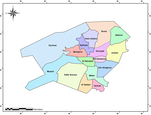
Damascus is divided into fifteen municipal districts which, in turn, are subdivided into ninety-five neighbourhoods. As a result of the city's urban expansion, its administrative boundaries are contiguous with its suburbs, which, from the administrative standpoint, form part of the Governorate of Rural Damascus. Some of these expansions are relatively new districts, such as Jaramana and Ashrafiyat Sahnaya, while others are historic towns such as Arabeen and Duma. It is noteworthy that numerous Damascene families have moved from the city to the suburbs, where the cost of living and real estate prices are lower.
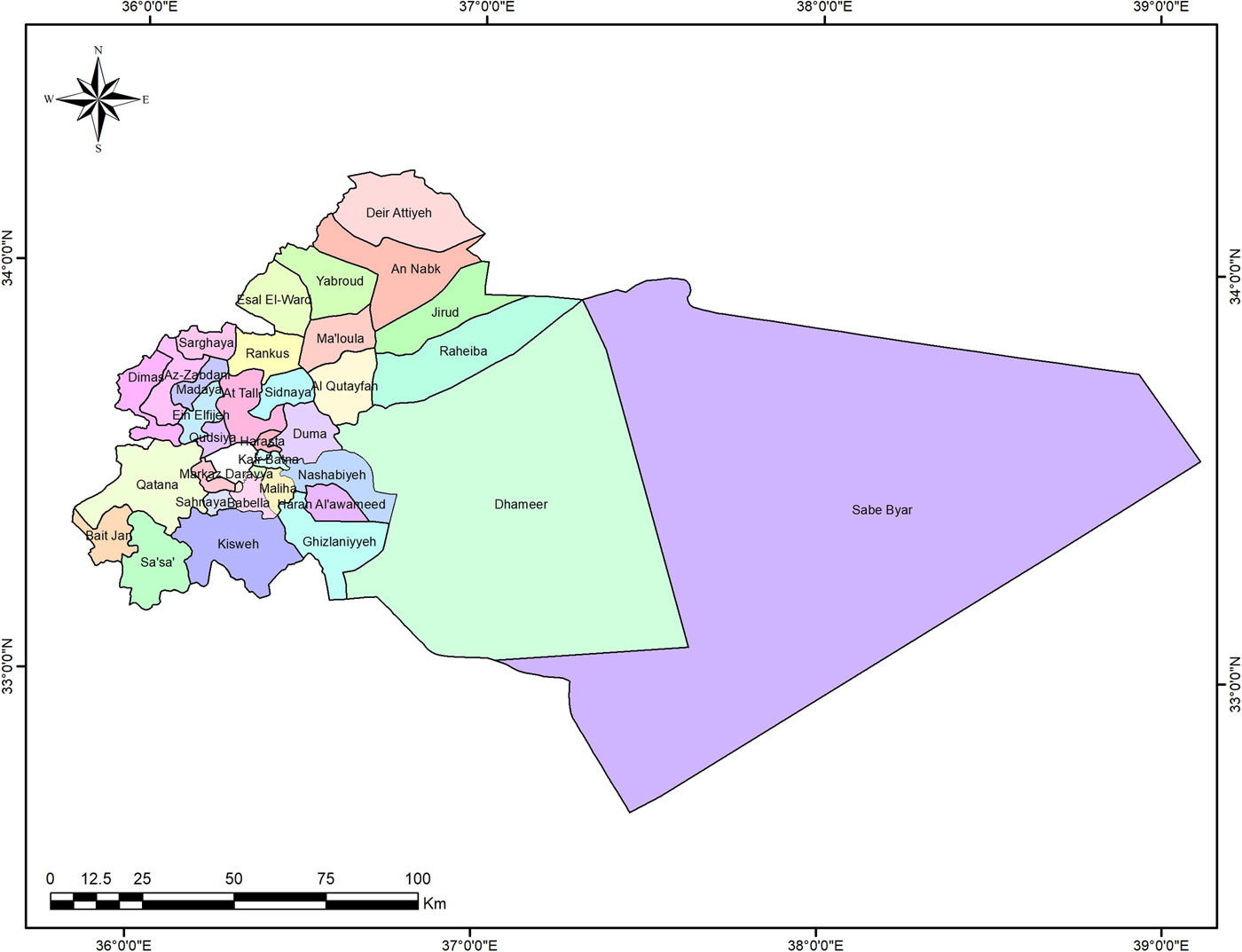
Rural Damascus consists of nine districts: Markaz (Central) Rural Damascus, Duma, al-Qutayfah, al-Tall, Yabroud, al-Nabk, al-Zabadani, Qatana, Darayya and Qudsayya. They comprise twenty-seven sub-districts, twenty-eight towns, 190 villages and eighty-two farms.
According to the 2010 census, the population of the city of Damascus, together with its rural hinterland, amounted to around 4.4 million persons, of whom 1.724 million were living in the Governorate of Damascus and 2.701 million in the Governorate of Rural Damascus.Footnote 3 From the standpoint of population size in Syria as a whole, the Governorate of Rural Damascus therefore ranks second after the Governorate of Aleppo.
The city of Damascus is linked and adjacent to, and largely integrated with, large parts of its environs which are administered by the Governorate of Rural Damascus, to such an extent that it is difficult to distinguish the administrative boundaries separating them in the contiguous built-up areas. It is impossible to obtain any separate socioeconomic statistical data or indicators for the city of Damascus, so the data for its contiguous rural hinterland must therefore be taken into account in order to form an accurate picture of the situation in the city.
Social agglomerations in Damascus and its environs
Urban Damascus
The districts of Damascus and its environs can be categorized in light of several socioeconomic indicators and characteristics. However, the religious indicator always provides a clearer distinction than all the other indicators, as in the case of districts such as al-Akrad, al-Salihiya, Abu Rummaneh, al-Maliki, al-Midan, al-Qassa'a, Nahr Eisha, Kafr Souseh, Dummar, Jabal al-Rizz, Wadi al-Mashari, al-Woroud neighbourhood, old parts of Damascus, Duweili'a and Jaramana. Although other indicators, such as income and economic level, are highly pertinent, they merely serve to support the religious indicator. Social studies on these districts could be undertaken in the future only through precise questionnaires designed to produce indicators concerning the impact of the crisis, its causes and consequences, and future projections.
The districts can also be categorized as traditional neighbourhoods, modern neighbourhoods, informal settlements, districts of villas and mansions, residential suburbs, towns within the city's hinterland, army or police housing, low-income housing neighbourhoods, ethnic neighbourhoods, special housing, and modern suburbs.
The Governorate of Damascus. Source: Governorate of Damascus, Report of the First Phase of the New General Topographer of Damascus and its Environs, Khatib and Alami Company, Urban Planning Directorate, 2010, p. 101. Image by Yassar Abdin.

Informal settlements are closed areas, populated exclusively by specific types of residents exhibiting a tribal defensive attitude towards neighbouring communities and urban society in general; they are not characterized by any economic, recreational or cultural activity that is allowed. Since their residents trade in smuggled merchandise and engage in a number of socially unacceptable activities, these areas are usually associated with misconduct and delinquency. They accommodate a large number of low-income and indigent persons.
Private residential neighbourhoods are areas inside the city that are inhabited by wealthy persons and persons with political and administrative influence. They are currently known as the “security zone” and contain a presidential palace and the residences of most of the high-ranking government officials. There are also areas outside the city, such as Qura al-Assad near al-Dimas and the Ya'four district, containing mansions and villas occupied by wealthy and influential persons and many government officials and army officers. All these high-income areas are well serviced and surrounded by strong barriers to ensure their protection.
Traditional neighbourhoods are old Damascene neighbourhoods, such as al-Midan, al-Salihiya and al-Shaghour, that are characterized by their high degree of social cohesion and the great pride that their residents take in appending these spatial honorifics to their names. The houses are handed down within the family from one generation to the next and are rarely sold to outsiders. They are mostly middle-income neighbourhoods but include many limited-income and some low-income residents.
The Governorate of Rural Damascus. Source: Governorate of Rural Damascus, Report of the First Phase of the Planning Project for Damascus Rif Governorate: General Technical Studies, 2011, p. 32. Image by Yassar Abdin.

The residents of ethnic neighbourhoods, such as al-Akrad, Jabal al-Rizz, Sayyida Zeinab and Jaramana, are proud of and deeply attached to their language, dialects, customs and culture. The city seems to have had little effect on the lives of these closed communities, which are impervious to cultural influence by the urban or neighbouring communities. They have many low-income residents.
Low-income neighbourhoods such as Masaken Mezzeh, Masaken al-Zahira and Masaken Barzeh, which were planned and built in the 1970s and 1980s, rank low on the social indicators due to their poor urban planning and layout, their failure to meet proper housing standards, their severe lack of public services, and managerial neglect to the extent that, in appearance, composition and characteristics, they have become more like informal settlements. They have many low-income residents.
Special housing complexes for intelligence, police and army personnel constitute fully self-contained entities with their own security systems, and they are usually walled and isolated from the urban and neighbouring communities, with which they have little physical resemblance. They are attached to their own administrations and are not subject to local administrative authorities or regulations.
Most of the modern suburban residential districts, such as Barzeh Prefabricated Homes, al-Zahira Prefabricated Homes, the Dummar Project and the Qudsayya Suburb, were developed in accordance with housing plans drawn up by public sector institutions. In contrast to the above-mentioned categories, they constitute successful social pilot projects since each of them exhibits a high degree of the diversity needed to ensure open-minded contact between all social classes, and they give a clear example of a healthy urban society that is not isolated or secluded. The demographic diversity manifested in the successful Dummar Project could serve as a model for the design of future middle-income housing projects in Damascus and its environs.
Geographic districts of Rural Damascus
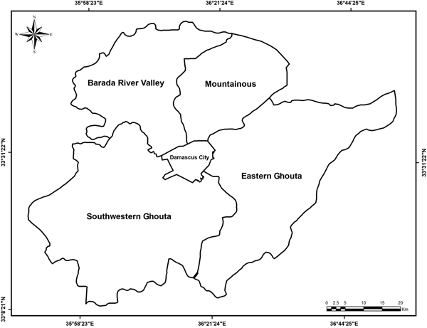
The Governorate of Rural Damascus comprises four geographical districts: the Eastern Ghouta district, the Southwestern Ghouta district, the Barada River Valley region, and the mountainous district.
The Eastern Ghouta district constitutes an extension of Damascus to the flat plains of the Hamad in the east and al-Talle and Mneen in the north, through which the Barada River flows, to Damascus and onwards to al-Utaybah Lake and al-Haijana. The population of the towns of Eastern Ghouta consists of closed cohesive communities maintaining strict religious observances and practices and not welcoming outsiders. Accordingly, the surplus population from the city of Damascus and other governorates has been absorbed selectively in a manner consistent with the prevailing social mores. Most of the newcomers originally lived in similar communities. While the indigenous population usually continued living in their traditional areas, the newcomers tended to settle in planned or improvised modern extensions. This gave rise to a new community that was fairly cohesive but separate from the migrants, even when the latter were from a similar social culture.
The majority of the population of the sub-districts and towns of Eastern Ghouta work in seasonal agriculture and some building and construction trades, from which they earn a low income. It is noteworthy that most of the land in Ghouta has been converted from agricultural to other uses. This was due to a lack of governmental planning, which led to a drop in land prices when such land fell prey to unregulated building and other uses and the majority of its farmhands became unskilled labourers working in the unregulated occupations that replaced agricultural activity.
The public authorities acquired vast areas of land at extremely low prices to establish a number of activities on both sides of the airport road passing through Ghouta. Areas of land were also acquired for the army by unspecified means, either by purchase or expropriation without any compensation or returns for their owners. Moreover, land prices in Ghouta fell in the real estate market due to a lack of planning and ongoing land pollution.
Notwithstanding the proximity of the towns of Ghouta to the city of Damascus, these towns differ from the city in regard to the extent and quality of available services, the most basic of which are lacking in almost all of the towns.Footnote 4
The Southwestern Ghouta district constitutes an extension of Damascus to the southwest, up to the borders of the southern Syrian governorates, and comprises the lands traversed by the A'waj River from its sources to the administrative boundaries of Damascus. It consists of flat plains extending without any natural obstacles to the fertile lands of the Houran plateau and opening onto Mount Hermon and all the southern districts. The towns of Southwestern Ghouta have a diverse population consisting mostly of closed cohesive communities except in some towns such as Sahnaya, Jdeidat Sahnaya and Qatana, which, after absorbing surplus population from the city of Damascus and other Syrian governorates, have established open communities from a homogeneous mixture of cultures. The other towns have manifestly retained a culture of seclusion, and many of their residents exhibit a sense of tribal rather than spatial belonging and remain staunchly impervious to the social culture and lifestyle of the towns in which they are living. This has given rise to closed communities living in the same space but without mutual interaction.
The majority of the population have incomes equivalent to those of public and private sector employees since most of them work in the services sector. The remaining few work in seasonal agriculture, nomadic stockbreeding or various building and construction trades. It is noteworthy that declining land prices have attracted many factories seeking to benefit from cheap labour in the district.
The district is suffering from a proliferation of military sites due to its proximity to the occupied Golan Heights region, and also from declining land prices due to the paucity of surface water and the depth of the groundwater aquifers. This was instrumental in the transformation of agricultural land into summer resorts for high-income holidaymakers, and the landowners who were thereby stripped of their property at paltry prices were obliged to work as labourers for the new owners.Footnote 5 Despite the population, agglomerations in this district lack basic services and the services that are available differ in type and quality from those provided in Damascus.
The Barada River Valley region is mountainous terrain interspersed with fertile plains that are separated from Damascus by Mount Qasioun in the northwest. The communities in the towns and sub-districts of the Barada River Valley are relatively open since they are in an area of summer tourist and holiday resorts. Although the region had a high population growth rate brought about by influxes of permanent residents and holidaymakers, all of the new planned or unregulated expansion projects were isolated from the conservative indigenous population living in their traditional habitats in which they were not in contact with the newcomers with whom they nevertheless shared a similar social culture. In addition, the large number of informal settlements that have sprung up alongside military camps constitute communities that are alien to the indigenous local community. Even after several years, there has been no integration or rapprochement between these communities. The administrative authorities concerned have not attempted to regulate social life or provide community security, nor have they organized collective cultural activities to alleviate the increasing intercommunal antipathy.
Main districts around the City of Damascus. Source: Damascus Regional Governorate, Report of Regional Strategies for Development Projects and Implementation Plans for the Regional Planning Project for Damascus Rif Governorate: General Technical Studies, 2012, p. 69. Image by Yassar Abdin.

The incomes of most of the residents of the towns and sub-districts have declined following the elimination of their agricultural and pastoral occupations. Most of these residents are now employed in the services sector, while the others are used as unskilled labour by the tourist and leisure facilities that have proliferated on the banks of the Barada River.
The public authorities acquired vast areas of land at extremely low prices for the implementation of a number of large projects and, as in all the districts, land was also acquired for military purposes. In addition, when this region began to attract holidaymakers, land passed into the hands of wealthy new owners through estate agencies which acquired it at derisory prices from its original owners, who subsequently worked for the new owners as labourers or watchmen.
The towns in the sub-districts enjoy better services than those provided elsewhere in the Governorate of Rural Damascus because they are a favourite destination for holidaymakers and tourists.Footnote 6
The mountainous district is the mountainous terrain to the north of Damascus from the town of al-Talle to the Qalamoun mountains. The population of its towns and sub-districts constitute closed cohesive communities due to their marked sense of religious and spatial belonging and their lack of receptiveness to outsiders. The district covers large areas ranging from primitive rural lands to urbanized holiday resorts such as Sednaya. Migrants from outside are rarely allowed to settle here, and the remote sub-districts such as al-Rhaiba have taken on a military appearance due to the army units that are deployed and accommodated there.
The towns and sub-districts that are far from Damascus have seen an exponential decrease in the incomes of their residents, the majority of whom are employed in the services sector and production facilities. Most of the sub-districts are neglected by the local administration due to their remote location, their unattractiveness and the influence exerted by the military zones.
The public authorities have acquired vast areas of land for numerous construction projects which, decades later, have never been implemented, and extensive areas were also acquired, without payment or appropriate compensation, for the purpose of widening roads and endowing them with a security perimeter. The district is suffering from the largest expropriations of land for military and other special purposes. Most of the sub-districts and their towns are suffering from the non-availability or inadequacy of services except in al-Talle, the local administrative centre.
Communities in rural Damascus
The population of Rural Damascus consists largely of the following generic communities, which are more disparate than those in the city of Damascus.
The people of Rural Damascus fall into six distinct categories: the peasantry, the Bedouin, new arrivals from other governorates, new arrivals from Damascus, Syrians displaced by the 1967 Six-Day War, and Palestinian refugees.
The peasantry are local townspeople, some of whom are currently employed in occupational sectors such as services, construction, automotive repair, commerce and manual labour, while the others continue to work in agriculture and stockbreeding. The term “peasants” is customarily applied to all of them. They bear names comprising a patronymic and a surname, and many of them own land and real estate.Footnote 7
The Bedouin are a group that arrived in Damascus from the Arabian Peninsula during the Ottoman era. Bedouin work principally in animal husbandry and agriculture. Clans use the name of the original tribe as a surname, and the majority are from the Al-Naeem tribe, a sedentary urbanized Muslim tribe and the largest in Syria. For the Bedouin, the ties of kinship are stronger than the ties of statehood, and they maintain the purity of their lineages through clan intermarriage.Footnote 8
New arrivals from other governorates include those who come to perform military service or to search for work. They often live near to their place of employment in close-knit communities bound by the ties of kinship, district, sect or historical nation, underpinned by their own language or dialect.Footnote 9
New arrivals from Damascus are former residents of Damascus who could not get accommodation in the city because of the housing shortage and high prices.Footnote 10
Syrians displaced by the 1967 Six-Day War are internally displaced persons. They are the former inhabitants of the southern regions who started arriving in 1967 owing to Israeli attacks against Syrian territories. Most are from the occupied Golan Heights region and the Governorate of Quneitra. They work in the service sector and other occupations and are generally poor. Their communities are overseen by the local authority.Footnote 11
Palestinian refugees came from Palestine and Jordan in 1948 as a result of the Palestinian exodus that year, known as the Nakba. They work in the service sector and other occupations but not in agriculture or animal husbandry because they do not own land and are generally very poor. International organizations help to care for these communities.Footnote 12
These six categories illustrate the current state of affairs in Rural Damascus. Far from achieving a rapprochement during the decades preceding the crisis, these communities remained at odds with each other, and the mental barriers between them were strengthened and transformed into physical barriers when the Syrian crisis erupted.
The population of Rural Damascus failed to comply fully with the spatial planning directives handed down by the government, and informal settlements were established as an easy way to circumvent them. This gave rise to closed neighbouring communities attracted from various regions and diligently preserving the particularities that led to their establishment.
The latent fragility of the population agglomerations in the city of Damascus and its environs is an indication of the weakness of the administrative structures in the area and the extent to which the social contract has collapsed due to the inability or unwillingness of the local administration to perform its basic functions, fulfil its regulatory obligations and shoulder its responsibilities to protect fundamental rights and freedoms, ensure the security and safety of its population, reduce poverty, provide services and manage resources in a transparent and equitable manner.
Damascus and its surrounding areas prior to 2010
Urban growth in Damascus developed at a steady pace until the second half of the twentieth century, after which it accelerated rapidly. The data indicate an unprecedented growth during the period from 2002 to 2010,Footnote 13 which led to a huge expansion of the built-up area, further loss of arable land and the proliferation of informal settlements forming a ring around the city.
The population of the city's planned neighbourhoods consists of class-, creed- and culture-based agglomerations which may be homogeneous to a large degree. The situation becomes more delicate if such neighbourhoods are virtually closed to outsiders, especially in regard to accommodation, property ownership and the practice of trades and professions. It is noteworthy that the new suburbs that have grown up around Damascus are playing an important role in the establishment of open neighbourhoods exhibiting the diversity and pluralism required in urban environments, under the supervision of their local authorities.
The city of Damascus is administered in accordance with a plan drawn up in 1968.Footnote 14 Despite numerous attempts, no plans to regulate the city's development have since been issued. Consequently, the problems caused by the adoption of several ill-considered planning decisions have had a detrimental effect on the socioeconomic situation of the population of the city and its environs. Being a large metropolis exercising considerable administrative, political and economic influence, the city has monopolized the resources of its rural hinterland for its own benefit at the expense of the rural districts, thereby increasing the socioeconomic developmental disparity between the city and those districts. Moreover, the city of Damascus has expanded by annexing adjacent districts or parts of towns in its rural hinterland and bringing them under its administrative and service structures in its own interest. The complex and costly application procedures for building permits, exacerbated by widespread administrative corruption, have led to a proliferation of unregulated construction that has considerably marred the city's overall appearance.
No planning studies or proposals for Rural Damascus have been published since it was declared a governorate independent of Damascus in 1972,Footnote 15 and under the concept that has been applied, namely “expansion of the spatial plan for rural towns”,Footnote 16 building permits could be issued for all types of land adjacent to the old plan. As a result, up to 80% of the construction projects in most of the rural areas close to Damascus have been unregulated, and shanty towns have become the most glaring manifestation of the low standard of urban development. The situation has been aggravated by inadequate provision of services, high population density and disregard for structural engineering norms and health requirements.
The local administrations in the districts have adopted the tactic of “acquisition” as a means to obtain land and real estate for the implementation of their vital projects in Rural Damascus, such as road construction and the establishment of industrial zones or housing estates, while neglecting to pay adequate and satisfactory financial compensation to the owners. Subsequent decades-long delays in implementation of the projects for which the acquisitions were made proved highly detrimental to the land concerned. When the administration failed to implement the projects, the former landowners sought to either recover their property through annulment of the acquisition orders or obtain some form of compensation by allowing their lands to be transformed into informal settlements.
Human agglomerations in the form of informal settlements have drawbacks from the standpoint of community security, since they are far from being residential areas in harmony and concordance with their surroundings. Families from a single village moving to an informal settlement bring their customs, traditions, values and lifestyles with them, and remain loyal to the locality from which they came. They have no sense of belonging to the wider society under the influence of which they are living, and may even feel antagonistic towards it.
The planned districts within the city of Damascus are also affected by the “informal settlement mentality” prevailing around them due to the ease with which the building codes and regulations can be circumvented. The ideology and culture of contravening the building regulations has spread inside the city to all the neighbourhoods covered by the spatial plan, where many infractions can be observed in the form of modifications and additions to previously constructed buildings and encroachments on planned public and private open spaces.
Although the local administrations have conducted numerous studies, they have not proposed any practical measures or ideas to develop Rural Damascus. They have not devised any means to open up the informal settlements and integrate them into urban society, nor have they resolved any of the planning problems. They have not formulated any plans to address the demand for housing or curb the growth of informal settlements. They have tackled certain aspects of specific problems merely by proposing solutions that could cause many other, more intractable problems. This has led to a total lack of public confidence in the local administrations and their promises, and has greatly diminished the population's hopes and expectations in this regard.
Damascus and its surrounding areas in 2011–18
The marginalized, fragile and socially closed districts were hit hard by the crisis, for which they constituted fertile ground in view of their intercommunal antipathy, aggravated by discontent that could easily be transformed into a high level of hostility. Such emotions were boosted by the primal tribal instincts that abounded in the recent memory of cohesive population groups which had suffered from a crushing accumulation of planning and regulatory problems in their districts. These problems began with the unfair expropriation of their land and included a long list of ill-considered attempts to address the plight of indigenous population groups and migrant communities in the informal settlements, in addition to their hostile negative attitude towards urban society and the local administrative structures. This created an explosive situation characterized by a state of general indignation which the rival factions viewed as an opportunity to recover usurped rights, redress inequities, ensure their self-defence or avenge themselves in a manner justified by the causes of that indignation. The factions mobilized under appropriate historical regional, ethnic and sectarian banners that incited all the closed communities to participate in the crisis.
The Syrian crisis began in March 2011 when numerous incidents took place in conservative neighbourhoods of Damascus. Although these were brought under control within the city, they spread to more cohesive communities in larger districts of Rural Damascus, where clashes broke out, especially after the crisis became fully militarized in 2012 and isolated the city from large parts of its rural hinterland and even from some of its suburbs. This led to mass migration from the conflict zones to safer parts of Rural Damascus. In general, the rural hinterland and even some of the city's suburbs witnessed recurrent skirmishes and battles, and the city suffered from road closures, a proliferation of security checkpoints and an influx of thousands of internally displaced persons from the districts surrounding Damascus into safe districts inside the city.
The increasing fragility during the crisis can be inferred from the mounting demographic and spatial pressures caused by the sporadic and random movements of refugees and the growing inherited sense of hostility felt by unfairly treated groups waiting for justice.Footnote 17 The socially closed districts, and particularly those inhabited by rural communities that had been neglected for the benefit of the city, as well as the informal settlements in the city's hinterland, formed appropriate environments in which extremist groups could be nurtured and harboured in view of the social cohesion of their residents, their low ranking in the socioeconomic indicators, the belief that they were being ill-treated by the city and their lack of any sense of belonging to urban society. The accumulated planning mistakes that had a direct or indirect effect in triggering the crisis can be summarized as follows:
• Failure to address the concerns of the ethnic, regional, tribal and confessional communities in the planned and unplanned districts.
• Failure to encourage cultural projects and activities designed to rally and unite the population around a single social objective, and allowing religious manifestations to assume the guise of important social activities and, as such, to receive support from the administrations concerned.
• Failure to respond in an earnest and reasonable manner to the demand for housing, failure to consider the issue of informal settlements from the standpoint of the interests of their residents and the landowners, and failure to prevent plans to address the issue of informal settlements from being transformed into opportunities for real estate investment or exploitation by influential traders at the expense of the indigenous population.
• Failure to address the issue of large-scale expropriations of land that, a quarter of a century later, has still not been used for the purposes for which it was acquired, and failure to provide the owners with realistic and adequate compensation for such land.
• Delays in rectifying the mistakes made in the planning and regulation of the city and its hinterland, failure to implement the proposed plan in a systematic, comprehensive and transparent manner, and reliance by decision-makers on improvised means to address problems and meet needs.
• Long-standing and severe lack of public confidence in the soundness of the decisions and means adopted by the administrative authorities to meet essential current and future needs.
As the events in the Syrian crisis evolved, the population sought refuge in the districts which, not having been directly affected by the conflict, were regarded as safe. Damascus suffered more than the other cities from high population density, housing shortages and the large proportion of home-seekers resorting to the informal settlements. Numerous economic and service-related problems arose and, since it remained safe during the crisis in which its neighbouring districts were damaged, the city became the principal place of refuge for the rural population and persons fleeing from cities in the conflict-torn governorates. This led to a serious population imbalance and demographic change in the city, as well as a consequent housing crisis, and its residents suffered from rising prices, unemployment and shortages in the provision of the principal services. A number of schools were turned into shelters for homeless persons, and green spaces, public parks and playing fields disappeared after being converted into investments in real estate and commercial and leisure centres. This was caused by the demand for space for the provision of alternatives to the unavailable services that were needed as a result of the higher population density. This had a detrimental effect on social life in Damascus neighbourhoods and the services sector came under pressure, especially in regard to health and compulsory, intermediate and university education, due to the large and sudden increase in the population during the years of the crisis. The relatively safe informal settlements, in which persons fleeing the high costs of housing in the city sought refuge, expanded and currently accommodate more than 60% of the internally displaced persons who moved to Damascus. Population density in the informal settlements was thereby doubled, placing increased pressure on the limited services available in the neighbouring planned districts.
During the crisis, the sociocultural divide motivated by homogeneous cohesion automatically became more entrenched in Damascus and its environs, and the local administration made no attempt to address this issue through sociocultural development projects. Damascus continues to suffer from this phenomenon, brought about by the population's agglomeration in regional and religious groups. The residents of the low-cost housing neighbourhoods, the traditional neighbourhoods and the informal settlements still preserve their closed sociocultural lifestyle to a large extent, and the administrations concerned treat them in a manner that perpetuates and deepens this divide through security checkpoints and special housing and residence permits. Even the open mixed neighbourhoods and suburbs in Damascus suffer from this phenomenon when they are surrounded by closed cohesive communities. This explains the highly fragile security situation, attributable to the presence of a hotbed ready to trigger the type of crisis that could degenerate into clashes and constitute a turning point at any time.
Characteristics of rural and urban environments during the ongoing crisis
It is evident from the course of events, up to the time of preparation of this paper, that the areas of conflict and armed confrontation around the city of Damascus have shrunk and, consequently, the number of districts requiring support and assistance to ensure their stability and security has increased. Several attempts have been made to enable displaced persons to return to the districts that are no longer scenes of conflict. Their service and technical networks are being rehabilitated by the local administrations and United Nations agencies and, in particular, by the Damascus delegation of the International Committee of the Red Cross. In the districts that are no longer scenes of armed conflict, public services and infrastructure have deteriorated to a large extent and there is a severe shortage of financial, technical and human resources. The serviceability of all the technical networks has deteriorated, and maintenance operations in the city have been delayed due to the lack of sufficient financial resources and technical expertise.
No men in the productive 18–25 age group play a socioeconomic role for numerous reasons, but primarily because they are performing compulsory military service, studying or living abroad. The same applies to those in the 25–45 age group, because they are either serving in the reserves or living abroad to evade military service. This has severely distorted the composition of the household and social structures and has weakened community safety.Footnote 18
Housing demand and rents have increased in all the planned and unplanned districts, and housing costs have risen out of proportion to the limited Syrian incomes. In the planned parts of the city, there are manifestations of unregulated activities exemplified by the presence of peddlers, particularly in kiosks and permanent pavement displays, at pedestrian crossings, and on top of walls outside buildings in the main streets. The number of unplanned residential and commercial buildings is continuing to increase throughout the city, and there has been an evident simultaneous increase in the growth of informal settlements.
Movement is difficult in the city's neighbourhoods and in the districts constituting its hinterland due to the numerous security checkpoints on all the roads and the closure of most of the streets and points of access in order to maintain optimum control and surveillance. There are no development projects to support the local population's continued existence and safety, and no lawful opportunities for secondary employment to cover the mounting costs of basic needs. None of the planning problems that arose prior or subsequent to 2011 have been addressed – planning mistakes are still proliferating, administrative reforms are being delayed and difficulties are still being tackled by the same methods applied before the crisis.
There has been a quantitative and qualitative decline in cultural activities and an increase in the cost of any remaining recreational activities. Since financial circumstances preclude expenditure on entertainment and luxury items, spending is limited to basic and essential items, and the availability of some of these items is affected by temporary or permanent shortages.
All sporting and cultural activities have diminished, and little concern is being shown for their facilities. Public open spaces and playing fields have been converted into economic investments for certain investors and, consequently, places in which communities could meet and manifest their solidarity have become commercial premises operated at high prices instead of being freely accessible facilities meeting important requirements for a peaceful social life. It is important to note that this signifies that the planning and regulatory failures which proved detrimental to the socioeconomic life of the various population groups in Damascus and its environs are continuing, and even increasing, in all the disturbed and peaceful districts.
The socioeconomic indicators for the population of Damascus paint the following picture. The economic situation of households is deteriorating on a daily basis, and their problems are being aggravated by the rising cost of their needs and the depreciation of the local currency, which has declined to less than one tenth of its value before the crisis. This has prompted people to use up any savings that they had, sell what they could manage without, seek secondary employment or request support from a charitable association. The main concern of households is to meet their basic needs on a daily or weekly basis, as they are unable to stock essential food supplies in advance. Although numerous local and imported commodities are available in the various district markets, the vast majority of the population are unable to obtain them due to their high prices.
Personal health care has deteriorated, and people are either resorting to traditional forms of herbal medicine whenever appropriate or relying on prayers and divine intervention when their maladies cannot be treated in that way. This is due to the fact that a large number of the physicians of the older generation who were well known in their districts have left the country and some local pharmaceutical laboratories have closed down. The prices of local, imported and smuggled medicines have risen, as have the fees for clinical examinations and procedures and the costs of hospitalization and all medical, surgical and pharmaceutical requisites.
By law, men in the 17–45 age group are subject to compulsory basic military service and may subsequently be required to serve as reservists. As a result, a large proportion of society's human resources are no longer productive because they have been conscripted for compulsory military service or service in the active reserve; they have evaded conscription by travelling outside the Syrian Arab Republic; or they have evaded conscription by absconding and not appearing in public places.
This legal obligation has had a detrimental impact on all the public and private production sectors and has also distorted the social structure as a whole.Footnote 19 The standard of all material and intellectual production has dropped, and the income of every household has declined because of the absence of at least one of its members performing military service. The financial circumstances and morale of households have been adversely affected and there seems to be little prospect of a solution to the problems of compulsory military and reserve service.
The crisis has affected all levels and branches of education, without exception, due to the large-scale loss of teachers and other qualified and experienced personnel through migration, as well as the lax application of administrative and statutory procedures to the academic cycles on which the education system is based. This has reduced the standard of educational output, and the exceptional measures and new laws that were introduced during the crisis to help students to succeed fostered a general feeling of indifference among them. These problems have been aggravated by the degraded infrastructure of the educational facilities as a whole, with the situation being even worse in special educational institutions.
No literary, artistic or musical works were presented in the Syrian Arab Republic as a parallel chronicle of the major events taking place there. This might be attributable to a lack of financial or moral support for cultural manifestations, fear of irresponsible reactions against cultural works by persons holding differing opinions, or other reasons that are difficult to determine.
A number of relatively new phenomena have appeared in local society, such as the full or partial military uniform worn by civilians having no connection with any military body. Such mimicry of military personnel reflects a desire to gain higher social status or dominate others through the fear that the uniform inspires. Weapons are carried by civilians and military personnel in their daily lives, leading to the use of those weapons during simple disagreements about places in a queue of vehicles waiting for petrol, arguments over taxi fares, etc. Public sector officials and private businessmen flaunt changes in their social status and their higher level of wealth than that of ordinary individuals.
The latent fragility of security
The severe and prolonged Syrian crisis has dislocated the historical cohesion of the components of Syrian society, the close and harmonious relations that have existed between its different cultures and religions and the similarities between their living standards and incomes, and has created deep rifts between the country's population groups. This might be attributable to the fact that individuals spontaneously fall back on their instinctive primal tribal cohesion when they lose the security provided by an urban administration. The symptoms of latent fragile security can be observed through the following terminology.Footnote 20
Communal introversion
The lack of improvement in the population's socioeconomic situation was an indication that no local or international public or private body had come up with any solutions or proposals to address the critical situation or remedy its causes. In actual fact, all the measures taken to tackle the planning situation in Damascus and its environs during the crisis merely exacerbated the schisms in the social life of the population as a whole. The inhabitants know each other by the traditional districts in which they live, and the old neighbourhoods consist of homogeneous and cohesive groupings in which a sense of belonging to the neighbourhood, with a commitment to its customs and traditions, and religious affiliation are usually the main driving forces. This ongoing spatial and religious affiliation may be carried over to the new residential districts in accordance with the planning theories which begin with a group's “incursion” into a residential district, their promotion of the district among other members of the group with a view to the latter's “translocation” and consequent achievement of residential “continuity” therein, and the subsequent establishment of a community akin to the community of origin. This is what happened in most of the new residential districts. Hence, all the districts, neighbourhoods and residential agglomerations can be distinguished and categorized by the social characteristics shared by their inhabitants. Most of the residential districts are characterized by their “communal introversion”, accompanied by a desire for security and safety other than that which should be provided by the local administrations.
Fragile cohesion
This introversion contributed to the escalation of events during the Syrian crisis and constituted a tinderbox that could trigger strife and violent confrontations. The environs of the city of Damascus currently give the impression of being a peaceful group of neighbourhoods, townships and informal settlements with distinctive and differing social, cultural, economic, religious and political characteristics but endowed with their own separate social cohesion independent of the urban society in Damascus. However, it should be noted that any of them could adopt a hostile attitude towards others during any occurrences that they regard as an existential threat. These districts are separated from each other by strict security measures, resembling walls, in the form of barriers and roads closed by concrete blocks and earth embankments with limited entry and exit points under security surveillance.
Fragmentation through introversion
The present-day security barriers and checkpoints have entrenched the division of the residential districts in the city and its peaceful environs along religious, regional and ethnic lines and even on the basis of economic class. These security measures have made the districts even more introverted than before and have prevented any residential intermixture, especially in regard to accommodation of the refugees flooding into Damascus and its environs, who are distributed in accordance with a security agenda consistent with the identity and characteristics of each residential district. This can be designated as fragile cohesion under the influence of security barriers, or fragmentation through the introversion to which communities resort when they feel insecure and need to achieve some minimum level of security and safety for themselves.
The above picture illustrates the fragility of the community security situation in the districts of Damascus and its hinterland as a whole, and clearly shows that this situation could take a catastrophic turn in the event of any party triggering strife. It is evident from the state in which the neighbourhoods and districts in the city of Damascus and its environs find themselves that the planning and regulatory measures needed to put an end to this social segregation in the residential districts are still being avoided or delayed. The primary requirement to resolve such critical situations is the practical implementation of physical planning solutions to mitigate the introversion of closed communities by enhancing the urban infrastructure, providing services, addressing regulatory problems, improving living standards and ensuring the availability of appropriate employment opportunities to alleviate the burdens on the population. There is a need for community participation to create a mindset in which people will be ready to assume responsibility for their social development.
The solution lies in the adoption of methods based on open-minded urban planning policies. The neighbourhoods used to be interlinked by commercial, recreational and cultural activities, and a balanced social cohesion can be restored only by taking earnest and resolute action. This could include interlinking the districts by removing anything that symbolizes a border; constructing roads and highways that traverse closed districts in such a way as to achieve a visual, cultural and economic interconnection; linking closed residential districts through the establishment of model cultural and economic activities, the attraction and influence of which would transcend their boundaries; improving public services, especially in regard to public spaces and parks, cultural facilities and sports clubs; and other measures conducive to interrelation and cohesion in important aspects of the population's daily life.
Assessment of the physical planning, social and security situations
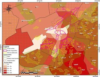
Community security can be assessed in light of a large number of principal determinants, the spatial accumulation of which was a direct cause of the crisis. Three of these determinants – informal settlements, poverty, and districts in which planning was delayed – have been selected for discussion below in view of their separate and direct spatial impact and the availability of relevant information and data that can be mapped, segmented and projected onto a map indicating the areas of armed conflict. The results show that the closed, ideologically strict and poor neighbourhoods suffering from administrative neglect largely coincide with the areas of armed conflict.
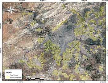
Informal settlements in the city of Damascus and its environs
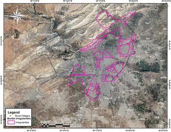
The difficulty of finding accommodation is one of the main problems facing the poor and middle classes. Consequently, informal settlements have sprung up within the administrative boundaries of the city and on the agricultural land of its rural hinterland to the east and south. These unplanned residential areas have proliferated to such an extent that they form an uninterrupted ribbon along the main roads around the city and even extend to the agricultural land in Ghouta and the State-owned land on the slopes and foothills of Mount Qasioun, thereby virtually surrounding the city from all sides.
These informal settlements are characterized by their high population density, ranging from 400 to 1,200 persons per hectare. Most of them are irregularly connected to public infrastructural services such as sewers, drinking water, electricity, telephones and roads. In appearance they are largely of a rural nature, as can be seen from the customs and habits of their residents, who breed poultry and even keep cattle in the interiors and on the roofs of their houses. Their layout is fairly standard in regard to street width and the absence of green and empty spaces, since they are intended mainly for residential purposes. Social services such as health and educational facilities and police stations are totally non-existent.Footnote 21
Their administrative links and other connections with the city depend on whether they are located within or outside its administrative boundaries. About twenty informal settlements have been established within the city's boundaries in areas not classified as residential, and more than twenty others are located outside the spatial plan but close to the city on the main roads linking it to districts within its region or on highways leading to other major cities.Footnote 22
Internal migration, primarily from areas with high unemployment to areas offering employment opportunities in the public or private sectors or better living conditions, is one of the most obvious causes of the growth and expansion of these informal settlements. Hence, the most prevalent pattern of internal migration has been from rural areas to the informal settlements in and around Damascus. These settlements have constantly expanded as a result of this uninterrupted migration by cohesive population groups to specific locations where, maintaining their ties of kinship, religious faith or regional links, they have formed communities bonded by similar sociocultural concepts and a shared history. They continue to lead their traditional lives in the closed community of the informal settlement, without merging or intermingling with the wider society around them, and maintain the traditions that they brought with them from their original habitat. On the whole, they form closed communal entities within Damascus and in its rural hinterland, and the residents of each informal settlement usually have virtually identical geographical origins and are loath to accept outsiders amongst them. This proclivity can give rise to hostility and the adoption of a defensive posture in regard to any form of integration into surrounding or neighbouring communities.
Poverty in Damascus and its hinterland
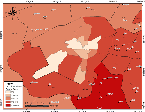
Poverty is an important indicator for any assessment of the districts in Damascus and its environs because it explains the population's basic socioeconomic structure. In Damascus, poverty has been found to be closely related to the educational level and occupational status of the head of the household.Footnote 23 The following table shows the areas with high levels of poverty in Damascus and its hinterland as determined by a United Nations Development Programme study conducted in 2005.Footnote 24 It is not surprising that these areas are situated on the eastern side of the periphery around Damascus and coincide to a large extent not only with the locations of the informal settlements in the city and its rural hinterland, but also with the rural districts. The problem of community security could be attributed to the contiguity of a number of impoverished, closed and mutually hostile population agglomerations with negative attitudes towards the metropolis, Damascus. Such a situation constitutes a volatile environment that could be ignited by any simple dispute deteriorating into a controversy and leading to a major intercommunal crisis.
Poverty rates in Damascus and its rural hinterland can be compared on the basis of the percentage of households living below the poverty line and the extent of the poverty gap in each governorate. These indicators show that in 2004, poverty rates amounted to 4.7% in Damascus and 5.44% in Rural Damascus; in 2010, these rates had risen to 9.17% and 11.89% respectively. The high increases in these rates during such a short period of time are alarming, and it is noteworthy that the poverty-stricken areas coincided spatially with the informal settlements in the hinterland of the city of Damascus.Footnote 25
Lack of follow-up to planning studies
The spatial plan regulating development and services in Damascus and its environs was drawn up fifty years ago. Several earnest attempts have been made to update it, and extensive local studies, some with assistance from various international bodies, have been conducted. However, none of these studies has been adopted, due to administrative and technical obstacles, differing personal interests and other ill-defined competing factors, and the entire Damascus region has therefore been left with an outdated spatial plan. Developmental operations are still being conducted on the basis of improvised planning and regulatory decisions, and the city's affairs are being run at the expense of its rural hinterland, which has been fully subordinated to it insofar as the city consumes the useful resources, such as drinking water, of its hinterland and exploits the latter as a dumping ground for its sewage, solid waste, industrial pollution, etc. This urban monopoly over the rural hinterland is exacerbated by the fact that the city is permitted to annex planned districts contiguous to its neighbourhoods and can expropriate any land in the Rural Damascus governorate for its own benefit.
Planning delays and the increasing demand for urban expansion, in order to absorb surplus population and satisfy the needs of other construction and real estate activities, led to a situation in which this demand was met by allowing exceptions and circumventing regulations. The widespread corruption in the local administrations was reflected in the deteriorating urban infrastructure of the planned districts and the large-scale proliferation of informal settlements. Planning delays were exploited as a means to trigger and escalate the crisis, and this applied, in particular, to the measures taken to prevent landowners from disposing of their property in many rural districts for years on the pretext that planning studies were pending, even though these studies were never conducted and sometimes never even announced. Projects for the development of seventeen areas in and around Damascus which had been planned years ago were never implemented, and public indignation was increased when the only project that was implemented was transformed into a series of real estate speculations that were far from being in the interests of the original owners. Rural Damascus as a whole reacted negatively to the planning delays. Those seventeen proposed planning areas will be segmented with the other data in order to provide a proper illustration of the impact of urban development.Footnote 26
Areas of armed conflict
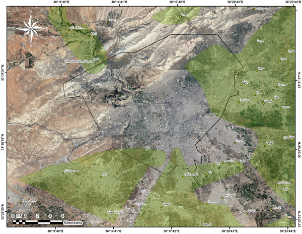
Maps of the armed conflict during the 2012–17 crisis were compiled on the basis of the chronology of major events that shrank or expanded the area controlled by any of the contending groups in Damascus and its rural hinterland. There were about 100 maps showing the areas of conflict during the last six years up to the time of preparation of this paper, as well as the front lines that witnessed the fighting and destruction and the areas which, no longer being scenes of conflict, could benefit from assistance to ensure the return and resettlement of their population. The latest map shows that the conflict has receded in some sub-districts of Eastern Ghouta such as Duma, Harasta, Arabeen, al-Nashabiyya, Kafr Batna and al-Hajar al-Aswad, which have begun to enter into direct or indirect negotiations and settlements. There is a need to collect data on the damage, establish working mechanisms, draw up proactive development plans for these newly conflict-free areas on the basis of an assessment of their needs, and mobilize resources for the provision of appropriate support to facilitate the safe return and resettlement of their populations. In view of the difficulty of determining the changes in a precise manner, it was decided to select a map portraying the situation in the third quarter of 2017 so that it could be segmented with the maps showing other changes.
The spatial coincidence of negative factors that helped to trigger the crisis
The spatial segmentation of the data in Figures 4, 5, 6 and 7 illustrates the relationship between the events taking place and the above-mentioned determinants. Figure 8 shows the close coincidence and constant correlation between the districts with high poverty rates, the informal settlements and the various closed communities sharing a feeling of injustice and marginalization, the latent fragility of which was manifest in their demands for planning rights, more equitable satisfaction of their needs and provision of the requisite services in their districts. This fragility was transformed into a state of armed conflict when it was aggravated by other special circumstances.Footnote 27
Informal settlements in and around the city of Damascus. Source: Regional Planning Commission, Report of the Informal Settlements of Damascus Rural Governorate, Municipal Ministry, April 2013, p. 43. Image by Yassar Abdin.

Poverty rates in Damascus and its rural hinterland. Source: Central Bureau of Statistics, Population Status Report of Damascus Governorate: Annual Statistical Collections from 2012 to 2017, Presidency of the Council of Ministers. Image by Yassar Abdin.

Proposed but unimplemented district plans. Source: Governorate of Damascus, Report of Detailed Planning and Organizational Studies for the Approved Urban Development areas in Damascus: Action Plan 2010–2025, Municipal Ministry, 2010. Image by Yassar Abdin.

Areas of armed confrontation in the environs of Damascus. Source: Rif Dimashq Governorate campaign, “Maps 2012–2018”, available at: https://en.wikipedia.org/wiki/Rif_Dimashq_Governorate_campaign. Image by Yassar Abdin.

The spatial coincidence of the accumulation of negative factors. Data intersection map by Yassar Abdin.

In fact, in all the districts and neighbourhoods of Damascus and its environs, it is possible to monitor this phenomenon of latent fragility, which, when aggravated, can turn into conflict. It went unnoticed for a long time, and no attempt was made to address it in a meticulous and practical manner by establishing databases, conducting analytical studies to interpret the occurrences and constructing development scenarios conducive to a peaceful future for these districts. Such studies should be conducted without further delay, and direct interventions will be needed to ensure the full recovery and rehabilitation of these districts in the specific manner required by their respective situations.
In general, all the neighbourhoods of Damascus need to open up to each other under the guidance of a strong and vigilant municipal administration pursuing a cultural reform programme and seeking to develop the city, resolve its problems and meet its requirements. The towns of Rural Damascus also need similar administrations capable of ensuring their development and rehabilitation on a basis of open-mindedness and closer cultural ties with urban society in the city. The objective should be to encourage closer relations between the various population groups, develop citizenship, promote patriotism and achieve a social stability in which changes can take place at a sufficiently gradual pace that would allow adaptation to all aspects of sociocultural development without any imbalances or fragmentation. In this way, those groups could eventually be able to enjoy the community security that constitutes the first line of defence for the protection of the homeland and its citizens against any internal socioeconomic dangers, at the same time ensuring a decent and tranquil life for individuals by dispelling their fears and endowing them with peace of mind and recognition of their presence and status as components of society. This necessarily implies that the local administrations, their official institutions and civil society organizations must assume heavy responsibilities in regard to the upgrading and equitable provision of public services in all districts, the satisfaction of needs and the establishment of an appropriate climate of social justice in which all communities feel accepted and secure and can cooperate within a harmonious framework in which a sense of belonging and loyalty to the wider society is promoted and disparities and controversies conducive to conflicts are rarely encountered.
When re-planning these districts, short- and medium-term development programmes need to be proposed in order to address, in a serious manner, a number of important issues. These include the equitable provision and distribution of public services in the towns and sub-districts; provision of decent housing and the formulation of a plan to resolve the problem of informal settlements; prevention of iniquitous expropriations; promotion of cultural activities exerting greater influence than religious activities; interlinkage of the districts through a network of roads wide enough to facilitate an effective transport system between them; and increased reliance on the tourism, recreational and economic activities for which each district is best known. Neglect or disregard of these issues could perpetuate the fragile security situation because of the potential reconstitution of closed communities characterized by extremist ideology either of a religious nature or relating to regional origin or ethnic affiliation.
There is a pressing need for a series of socioeconomic measures, programmes and plans to fully ensure the well-being of all members of society and optimize the development of their capabilities to an acceptable degree within a framework of political freedom and social justice which would make every individual better able to assume his or her responsibility for the achievement of social development and progress. Self-knowledge and close familiarity with their environment and civil obligations make people more aware that the source of their security lies within themselves when they fulfil their humanitarian and civil obligations and duties towards the society in which they live.