INTRODUCTION
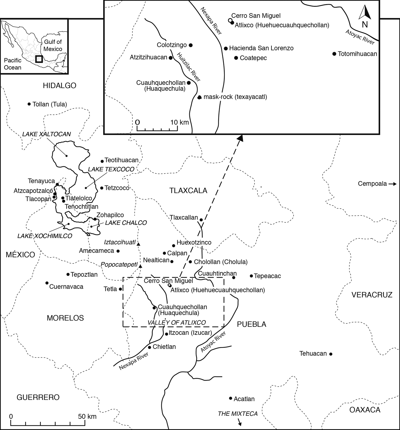
The Valley of Atlixco (Figure 1a) occupies an area of approximately 400 km2 in the west of the state of Puebla in the central highlands of Mexico (Figure 1b). As one descends the southeastern slopes of the volcano Popocatepetl, ravines and escarpments to the north and west give way to flat lands to the south and east, providing natural access both to trade routes and to plains where pre-Columbian battles are said to have been fought. Its climate, ranging from temperate at higher elevations to hot at lower elevations, its fertile soils, and its abundant rivers, including the Nexapa, Atoyac, and Huitzilac, have long made the valley conducive to agriculture. Despite the importance, not least of which was commercial, economic, and military, of the Valley of Atlixco to the pre-Columbian history of Mesoamerica, it has not received as much attention from scholars as it warrants.
Valley of Atlixco and central highlands, Mexico.

The purpose of this paper is to illustrate that importance by reviewing the ethnohistoric sources in light of recent archaeological and iconographic findings from the sites of Atlixco and Cuauhquechollan. Atlixco—the settlement referred to in the ethnohistoric sources as Cuauhquechollan—was occupied continuously from the Early Preclassic period until the middle of the Late Postclassic period (a.d. 1443), when it was relocated to the present town of Huaquechula. This new settlement retained the name, Cuauhquechollan, while the original settlement became referred to as Huehuecuauhquechollan (Old Cuauhquechollan). In conformity with most of the ethnohistoric sources, however, we use the name, Cuauhquechollan, to refer to the settlement of Atlixco until the time of its relocation. The evidence consists of a variety of ethnohistoric sources, the archaeological record (settlement patterns and ceramic materials), and the iconography of the Late Postclassic period sculptures and carvings located in and around Huaquechula.
We begin by summarizing the nature of the evidence and commenting on the challenges of correlation. We then present a chronological overview of the Preclassic, Classic, and Postclassic periods, focusing on points of overlap and ambiguity between the ethnohistoric and archaeological evidence. We further assess the relationship between the iconographic evidence from sculptures and carvings and the political development of the Valley of Atlixco during the Late Postclassic period. We conclude by summarizing our findings and identifying areas of research that should be pursued in the future.
THE NATURE OF THE EVIDENCE
The ethnohistoric evidence of Cuauhquechollan consists of postconquest and early colonial period sources from a variety of locations and perspectives, many steeped in myth. Some—such as the Genealogía de Cuauhquechollan, the Mapa Circular de Cuauhquechollan, the Codex Huaquechula, and the Lienzo de Cuauhquechollan (Asselbergs Reference Asselbergs2004)—were created by the Cuauhquecholtecas, themselves. Others, such as the Historia Tolteca-Chichimeca (Kirchhoff, Güemes, and García Reference Kirchhoff, Lina and Luis1989) and the Mapa de Cuauhtinchan No. 2 (Ruiz Medrano Reference Ruiz Medrano, Carrasco and Sessions2007), were created by the Nahua and the Pinome factions, respectively, of Cuauhtinchan, Puebla. Although some may have been intended for local audiences, most found their way into the courts of New Spain to defend the rights and privileges of their indigenous creators. The Codex Mendoza (Berdan and Anawalt Reference Berdan and Anawalt1997) is a tribute list from Tenochtitlan created at the request of the first Viceroy of New Spain, Antonio de Mendoza. There are also the works of Ixtlilxochitl (Reference Ixtlilxochitl and Chavero1965), Muñoz Camargo (Reference Muñoz Camargo1998), and Tezozomoc (Reference Tezozómoc, Orozco and Berra1975) whose “transcultural discourses” (Velazco Reference Velazco2003:17) were attempts to negotiate the waning power of the indigenous elite during New Spain's early colonial period. To these can be added the accounts of the Spaniards, Cortés (Reference Cortés1993) and Vázquez de Tapia (Reference Vázquez de Tapia1972), whose interests lay in being rewarded by the Spanish Crown for their participation in the conquest of Mexico. Finally, there are the accounts compiled by the Franciscan friars, Motolinia (Reference Motolinía and O'Gorman1995), Olmos (Histoire du mechique Reference Kinatana2005), and Torquemada (Reference Tezozómoc, Orozco and Berra1975), and the Dominican friar, Durán (Reference Durán and Heyden1994), whose detailed knowledge of indigenous cultures was used to facilitate religious conversion. Although there is no single “historical truth” (Gillespie Reference Gillespie1989:xxi) that can be gleaned from such a variety of sources, sufficient overlap exists between them to weave together a fairly coherent narrative of the pre-Columbian history of Cuauhquechollan.
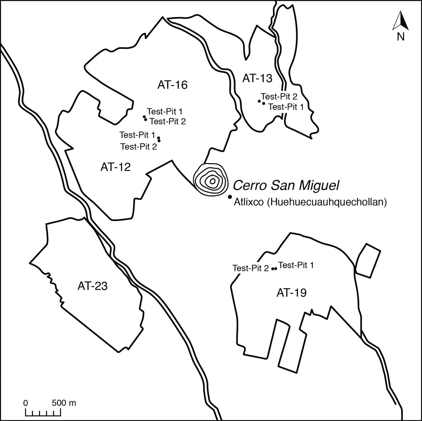
These sources form the backdrop to the archaeological evidence from Cuauhquechollan, much of which consists of unpublished surveys, reports, and conference papers. To the published works by Plunket (Reference Plunket1990), Plunket and Blanco (Reference Plunket and Blanco1989), Plunket and Uruñuela (Reference Plunket and Uruñuela1991–1992; Reference Plunket, Uruñuela, Hodge and Smith1994), and Sánchez de la Barquera de Arroyo (Reference Sánchez de la Barquera Arroyo1996), however, we add that by Morales Cano (Reference Morales Cano1991) whose Licenciatura thesis research is the only study of the site of Atlixco to use both surface surveys and test-pit excavations. Its main objectives were to establish the site's spatial and temporal distribution, density of occupation, and cultural affinities with surrounding pre-Columbian sites, and to contribute to the reconstruction of the ceramic sequence of the Valley of Atlixco which, to date, is incomplete. Surface surveys were carried out on non-urbanized lands within a 2 km radius of Cerro San Miguel (Figure 2). The lands were divided into four collection areas (AT–12, AT–13, AT–19, AT–23) delimited by natural boundaries such as rivers and ravines. Within each area, parcels of land were used as collection units and the presence (abundant, moderate, or scarce) or absence of ceramic materials was recorded. Those locations with abundant ceramic materials, including AT–16, were chosen for the excavation of eight, 2 X 2 m test pits (permission to excavate AT–23 was unable to be obtained). The materials were grouped according to one or more of their attributes (surface finish, decoration, paste, and form) and identified by comparing them to types from nearby sites or from those with well-established ceramic sequences. When no similar materials were found to which they could be compared, they were described and assigned a name. The evidence suggests that Atlixco was a multi-component site containing, as it does, ceramic materials from the Preclassic, Classic, and Postclassic periods.
Areas of surface surveys and test-pits around Cerro San Miguel.
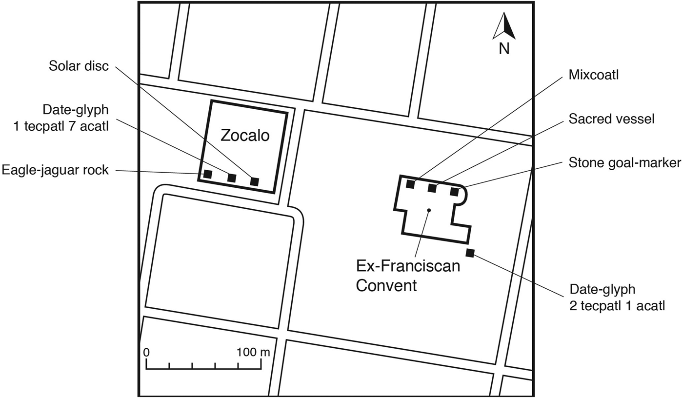
Researchers (Morales Cano Reference Morales Cano and Cano2009; Plunket Reference Plunket1990; Plunket and Uruñuela Reference Plunket, Uruñuela, Hodge and Smith1994) have also conducted preliminary interpretations of the basalt and limestone sculptures and carvings located in or near the present town of Huaquechula (Figure 3). Because there is no clear archaeological evidence of permanent settlement in the area before the Late Postclassic period (Plunket Reference Plunket1990:10), all are likely representative of what Boone and Smith (Reference Boone, Smith, Smith and Berdan2003:189) refer to as the Late Postclassic international symbol set. Only two of the sculptures remain in their original locations. The rest have been relocated to Huaquechula's central plaza (zócalo) or to the Regional Museum of Puebla. If their original locations were ever recorded, the information is no longer available, a phenomenon that Umberger (Reference Umberger, Berdan, Blanton, Boone, Hodge, Smith and Umberger1996:167, 179) notes for many free-standing sculptures from the Late Postclassic period. The carvings are embedded in the walls of the Franciscan convent of San Martín Caballero, referred to as the ex-Franciscan convent, built by indigenous laborers between a.d. 1530 and 1560 (Kubler Reference Kubler1972:64). Some of the carvings may have been salvaged from pre-Columbian structures such as the wall that surrounded Cuauhquechollan, discussed below, but not likely from the Mexica garrisons that were erected on the borders of Cuauhquechollan and Atzitzihuacan (Durán Reference Durán and Heyden1994:436). Those were probably the “lodgings and accommodations” that were “looted and burned” (Cortés 1992:91) in the siege on Cuauhquechollan by the Spaniards and their indigenous allies in a.d. 1520. Other carvings may have been made at the request of the friars, although it seems unlikely that they would not have understood the symbolism of those associated with human sacrifice. Regardless of their origins, they were likely incorporated into the walls of the ex-convent as simple decoration, removed, as were others (Gruzinski Reference Gruzinski and Corrigan1993:39), from their original context and divested of meaning. Nonetheless, both the sculptures and the carvings speak to various influences—including that of the Triple Alliance (Tenochtitlan, Tetzcoco, Tlacopan), the independent polities of Huexotzinco and Tlaxcallan, and the Mixteca Alta—on the Valley of Atlixco, in general, and on Cuauhquechollan, in particular.
Locations of sculptures and carvings, Huaquechula.
The attempt to correlate different types of evidence is not an easy task. Not only do they deal with “distinct aspects of [a] culture” (Nicholson Reference Nicholson1955:596)—the ideational and the material—but they represent “different forms or views of reality” (Charlton Reference Charlton1981:155). In addition, they are often “fragmentary” or “discontinuous” (Charlton Reference Charlton1981:155). All of these challenges apply to both Old Cuauhquechollan and Cuauhquechollan. The ethnohistoric evidence must be pieced together from a wide variety of sources, some of which are mythological in nature. Such evidence, however, is far more abundant than the archaeological evidence. First, because the present city of Atlixco has been undergoing rapid economic development, salvage archaeology has become a necessity. Second, the lack of an accepted ceramic sequence for the Valley of Atlixco does not always allow for temporal distinctions to be made within each of the Preclassic, Classic, and Postclassic periods. And third, what little archaeological research that has been conducted in the present town of Huaquechula has not been published. As to the iconographic evidence, it is, in part, speculative because most of the sculptures and carvings have been removed from their original contexts. Nonetheless, the careful use of a combination of sources—in this case, ethnohistoric, archaeological, and iconographic—has the potential to provide a better understanding of a site's pre-Columbian history than would the use of only one source.
THE VALLEY OF ATLIXCO BEFORE THE POSTCLASSIC PERIOD
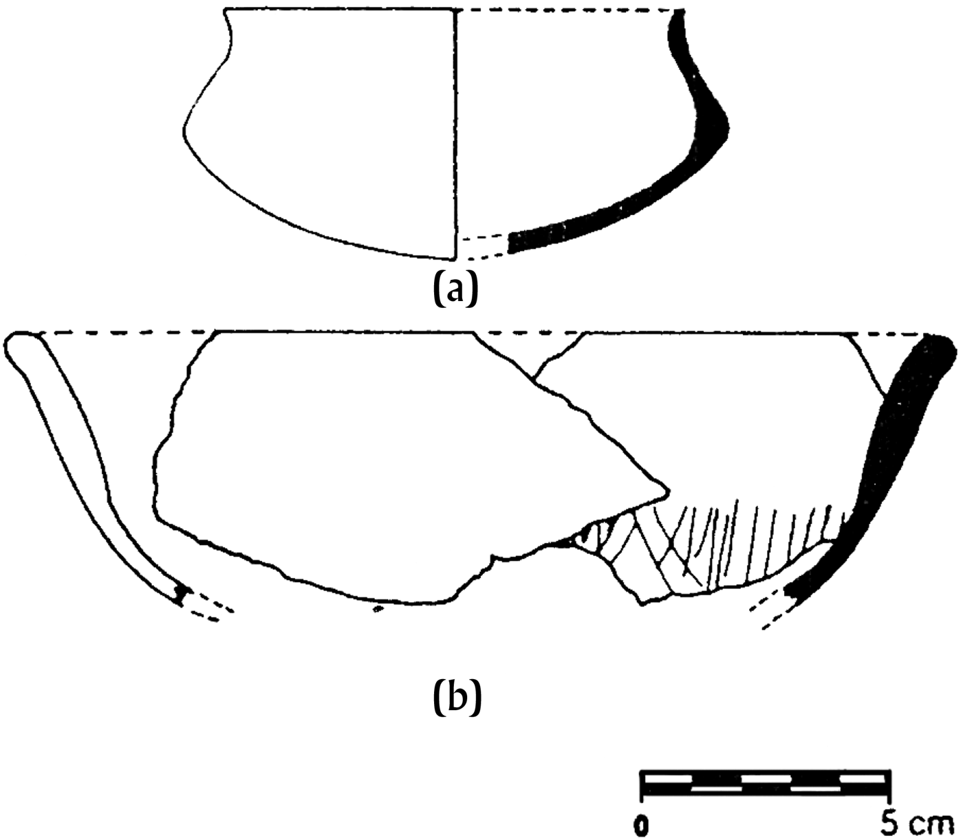
Little doubt exists that the Valley of Atlixco had been occupied for millennia, first, by foragers and later by sedentary farmers (Plunket Reference Plunket2005; Plunket and Uruñuela Reference Plunket, Uruñuela, Evans and Webster2001). Around the site of Atlixco, surface surveys revealed a moderate quantity of ceramic materials from almost the whole of the Preclassic period (1200 b.c.–a.d. 200/250). The densest finds, mainly from the Middle Preclassic period (900–300 b.c.), were located to the southeast (AT–19) and southwest (AT–23) of Cerro San Miguel (Morales Cano Reference Morales Cano1991:26, 35, 40). In AT–16, test pit 2, the remains of a hearth were found in association with fragments of Negro Pulido ware—a diagnostic local monochrome, polished and engraved (Figure 4). In surface finish and decoration, it is similar to Tortuga Pulido Tardío ware from the Middle Preclassic but, in form, to Cesto Blanco Tardío composite-silhouette bowls from the Late Preclassic (300 b.c.–a.d. 200/250), both from Zohapilco on Lake Chalco (Niederberger Reference Niederberger1976:116, 134–135). The ceramic materials–similar to those from the basin of Mexico, the Valley of Morelos, Tehuacan, and the Gulf Coast–suggest that Cuauhquechollan was located on or near a trade route of commercial importance between the Central Highlands and the Gulf Lowlands (Morales Cano Reference Morales Cano and Cano1991:201). Their distribution suggests a dispersed settlement pattern surrounded by fertile lands of economic importance in supplying agricultural products to larger and more complex Middle and Late Preclassic period sites (Morales Cano Reference Morales Cano and Cano1991:37, 201–202) such as Colotzingo (Uruñuela Reference Uruñuela1989:115). After Colotzingo was permanently abandoned at the end of the Late Preclassic period, Cuauhquechollan continued to be inhabited, but its settlement pattern would change in the Classic period (a.d. 200/250–800/900) when cities such as Teotihuacan and Cholula flourished.
Negro pulido compound-silhouette bowls.
When Teotihuacan was at its height, its rulers oversaw trade along the Teotihuacan Corridor (García Cook Reference García Cook, Sabloff and Bricker1981:267) which ran from northern Tlaxcala (Carballo and Pluckhahn Reference Carballo and Pluckhahn2007:614, 622) to the Gulf Coast, on the one hand, and to the Valley of Oaxaca, on the other, by branching south at Cholula and continuing on through either Atlixco, Izúcar, and Acatlán or else Tehuacan. By the Classic period, Cholula had become an important religious and trade center in its own right, interacting with but independent of Teotihuacan.
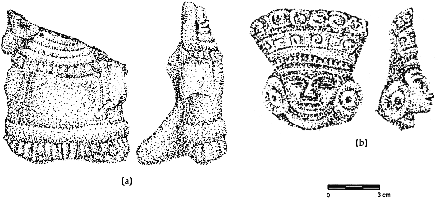
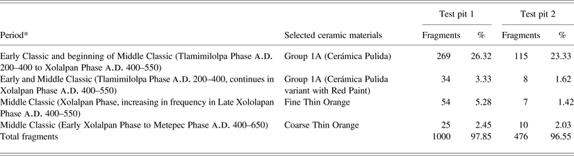
Rather than administering blocks of territory beyond the Basin of Mexico, Teotihuacan controlled key settlements for strategic or commercial purposes (Cowgill Reference Cowgill2008:970). The Classic-period site of Hacienda San Lorenzo, for example, appears to have been a small Teotihuacan enclave, independent of local control, that oversaw trade in either ceramics or the contents therein (Plunket and Blanco Reference Plunket and Blanco1989:120, 130). During this time, the commercial importance of Cuauhquechollan appears to have increased. Its dispersed settlement pattern became concentrated to the northeast (AT–13), possibly to take better advantage of its proximity to the Teotihuacan Corridor (Morales Cano Reference Morales Cano1991:202). Ceramic materials from both surface surveys and test pits in AT–13 included Group 1A (Polished Ceramic) and Group 1A (Polished Ceramic with Red Paint), similar in both form and decoration to the divergent-walled, monochrome and bichrome bowls with button supports from Hacienda San Lorenzo (Blanco Reference Blanco1988:60, 67); and Fine Thin Orange and Coarse Thin Orange, similar to those from Teotihuacan (Rattray Reference Rattray, Rattray, King and Oyarzábal1981:61, 63) (Table 1). Thirteen Teotihuacan-style figurines (Figure 5), similar to those at Hacienda San Lorenzo (Blanco Reference Blanco1988:104), were also found at AT–12, AT–13, and AT–19.
Teotihuacan-style figurines: (a) flat body and back support (Teotihuacan IV); (b) Type 26 (Teotihuacan IV).
Temporality of selected ceramic materials (AT-13)
*After Rattray (Reference Rattray, Rattray, King and Oyarzábal1981).
By a.d. 500/550, the power of Teotihuacan had come to an end. Sites such as Hacienda San Lorenzo were abandoned; others, such as Atlixco, appear to have remained under local control throughout the whole of the Classic period (Plunket Reference Plunket1990:6). Around a.d. 600, the Olmeca Xicalancas from the Gulf Coast are said to have come to dominate the whole of the Puebla-Tlaxcala Valley, including Cholollan and Cuauhquechollan (Kirchhoff, Güemes, and García Reference Kirchhoff, Lina and Luis1989:257, Map 5). At this time, the settlement pattern of Cuauhquechollan became concentrated to the northwest in what might have been a defensive location at the foot of Cerro San Miguel (AT–12). Monumental architecture also began to be built nearby. The six structures reveal diverse stages of construction (Schmidt Reference Schmidt1974; Suárez Reference Suárez1985), suggesting continuous occupation of Cuauhquechollan from the Epiclassic period (a.d. 650–900) to at least the beginning of the Late Postclassic period (a.d. 1443) (Morales Cano Reference Morales Cano1991:40, 202). As to Cholula, McCafferty (Reference McCafferty1996:12) suggests that, unlike Teotihuacan, it did not fall, but underwent a “gradual transition” in occupation between the Classic and the Postclassic periods, with only partial abandonment in the Early Postclassic period.
ETHNOHISTORIC ACCOUNTS OF THE POSTCLASSIC PERIOD
The Early Postclassic Period (a.d. 900/1000–1200)
After the Olmeca Xicalancas had arrived in the Puebla-Tlaxcala Valley, the Tolteca Chichimecas and the Nonoalca Chichimecas are said to have arrived in Tollan (Tula) (Kirchhoff, Güemes, and García Reference Kirchhoff, Lina and Luis1989:12). Although the scope of Tula's power is still uncertain, its cultural influence, like that of Teotihuacan, would extend throughout Mesoamerica. In fact, its cultural influence might be why sixteenth century ethnohistoric sources focus not on its commercial, economic, or military importance, but on migration myths surrounding its collapse.
Following Davies’ (Reference Davies1977:383, Reference Davies1980:161) sequence of events, the Tolteca Chichimecas were the first to abandon Tollan for Cholollan where they overthrew the Olmeca Xicalancas (Kirchhoff, Güemes, and García Reference Kirchhoff, Lina and Luis1989:160). Soon, however, they were forced to seek military assistance from seven Chichimec tribes in Chicomoztoc, pictured in the “undoubtedly metaphoric” condition (Ruiz Medrano Reference Ruiz Medrano, Carrasco and Sessions2007:94) of hunters and gatherers. Their mission in Cholollan accomplished, the Chichimecs dispersed, three establishing themselves to the northeast and four in Totomihuacan, Cuauhtinchan, Tlaxcallan, and Huexotzinco, respectively. From near Huexotzinco, two leaders, Tloquetzalteuhtli and Yohuallatonac, established themselves in Cuauhquechollan and a third, Quezalxiuhtli, in Coatepec (Muñoz Camargo Reference Muñoz Camargo1998:63; Torquemada Reference Torquemada1975, I:361).
Instead of going to Cholollan, Mixcoatl, the Chichimec leader of the Tlaxcaltecas, returned to the Basin of Mexico where, according to the anonymous Anales de Cuauhtitlan (Reference Velázquez1975:33), his son, Ce Acatl Topiltzin Quetzalcoatl, came to rule Tollan as its king and priest from a.d. 1153 to 1175. His tragic fate at the hands of Huemac who ruled Tollan at almost the same time as head of a faction loyal to the god, Tezcatlipoca (Cobean and Mastache Flores Reference Cobean and Flores2007:34), is recorded in numerous accounts. Three of those—the Histoire du mechique (Reference Kinatana2005) from the basin of Mexico, Ixtlilxochitl (Reference Ixtlilxochitl and Chavero1965) from Tetzcoco, and Muñoz Camargo (Reference Muñoz Camargo1998)/ Torquemada (Reference Torquemada1975) from Tlaxcallan—specifically mention Cuauhquechollan.
Of particular interest is the Histoire du mechique (Reference Kinatana2005) which relates how Tezcatlipoca used sorcery to drive Quetzalcoatl from Tollan. Making his way to Cuauhquechollan, Quetzalcoatl “prepared a temple and an altar for himself” and was adored as a god, “and there he stayed for 290 years” (Histoire du mechique Reference Kinatana2005:115). From Cuauhquechollan, Quetzalcoatl went to Cholollan, where he stayed for more than 100 years, then to Cempoala, where he stayed for more than 200 years until, learning that Tezcatlipoca was pursuing him, he fled to a desert and died. The fact that indigenous informants from the basin of Mexico made reference to “a temple and an altar” in Cuauhquechollan may have been based on their knowledge of the aforementioned monumental architecture that archaeologists discovered northwest of Atlixco (AT–12). Past visual inspections of one of the six structures suggest that it had been between 30–40 m long by 10–15 m wide, approximately 2 m high (Schmidt Reference Schmidt1974), with stuccoed walls and exposed frets, and stuccoed floors (Suárez Reference Suárez1985). Recent visual inspection suggests that the largest of the six structures had consisted of a large platform approximately 40 m long by 30 m wide, with what appear to be the remains of columns approximately 15 m high (Morales Cano and Allende Carrera Reference Morales Cano and Carrera2009:2). The structures at AT–12 seem to have been far smaller than others that had been built earlier in the Valley of Puebla-Tlaxcala (Plunket and Uruñuela Reference Plunket and Uruñuela2012:22) and, due to natural erosion and human activity, they have been deteriorating rapidly. Nonetheless, their presence suggests a civic-ceremonial function of what had become a nucleated and densely populated settlement (Morales Cano Reference Morales Cano1991:43).
According to the Historia Tolteca-Chichimeca (Kirchhoff, Güemes, and García Reference Kirchhoff, Lina and Luis1989:28), once Topiltzin Quetzalcoatl had been driven from Tollan, Huemac was killed by the Nonoalca Chichimecas who then also abandoned it. Led by Xelhua, their circuitous route eventually took them to Cuauhquechollan, Tehuacan, and on to the southeast (Kirchhoff Reference Kirchhoff1940:Map 1). Whatever Xelhua's fate (Motolinía Reference Motolinía and O'Gorman1995:5 [Epístola proemial]; Kirchhoff, Güemes, and García Reference Kirchhoff, Lina and Luis1989:45, 55), the ethnohistoric sources make no further mention of either him or the Nonoalca Chichimecas in relation to Cuauhquechollan, essentially writing them—and others—out of the record (Leibsohn Reference Leibsohn2009:48).
In the Valley of Atlixco, surface surveys yielded Black-on-Orange ware similar to that of Early Postclassic Cholula (Cholulteca I, a.d. 800–900) (Plunket Reference Plunket1990:6–7; Plunket and Uruñuela Reference Plunket, Uruñuela, Hodge and Smith1994:437). One of the areas with the highest frequency of Black-on-Orange ware was to the “east and south” of Cerro San Miguel—the non-defensive area of Cuauhquechollan (Plunket Reference Plunket1990:8), presumably AT–19—which suggests that this was a time not only of the increasing importance of Cholula, but also of relative peace.
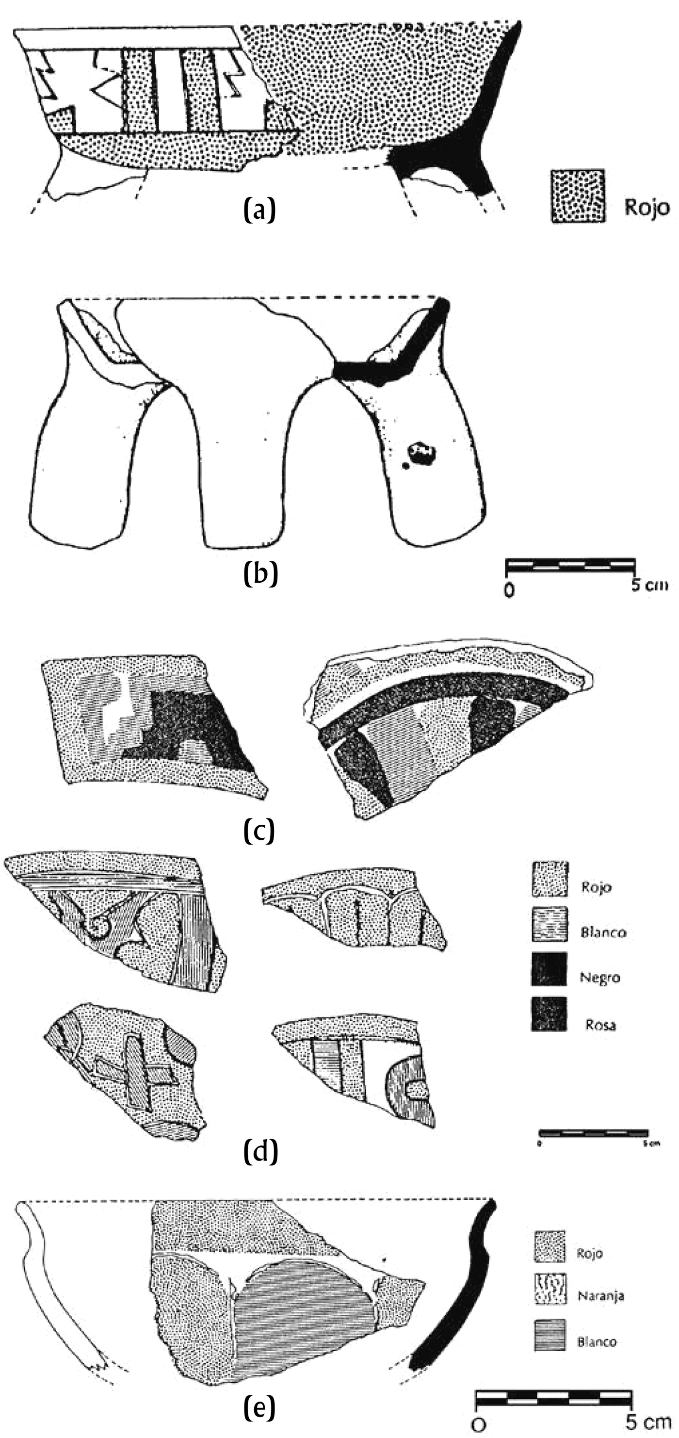
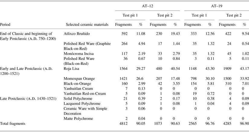
Excavations at both AT–12 (test pit 1) and AT–19 (test pits 1 and 2) corroborate the high frequency of Black-on-Orange ware (Table 1). Those at AT–12 (test pits 1 and 2)—in the area of the six structures to the northwest of Cerro San Miguel—further revealed the presence of two diagnostic ceramic types. The first type, Atlixco Bruñido, is a polychrome (brown, red, orange or pink, and white), sometimes incised or engraved (Figure 6). Some fragments are similar in form to the Guadalupe Red/Coffee divergent-walled bowls of Tula's Prado Phase (a.d. 700–800) (Mastache et al. Reference Mastache, Cobean, Crespo and Healan1982:91–92) and to the Red-on-Buff divergent-walled bowls of the Early Toltec Phase (a.d. 750–900) (Parsons et al. Reference Parsons, Brumfield, Parsons and Wilson1982:428). Others are similar in both form and decoration to the Polished Red Ware (Graphite Black-on-Red and Black-on Red) of the Aztec I Phase (a.d. 950–1150) from Tetla, Morelos (Norr Reference Norr and Grove1987:530). Plunket (Reference Plunket1990:8), likewise, notes the stylistic similarity between the Black-on-Orange ware from Early Postclassic Cholula and that from Morelos. The second type, Monócroma Incisa, includes grayish-brown or orange convergent-walled bowls, polished and incised. Some fragments are similar in decoration to the Polished Red Ware (Graphite Black-on-Red) from Tetla, Morelos. Others are similar in surface finish to Momoxpan Orange from Postclassic Cholula. According to Sánchez de la Barquera Arroyo (Reference Sánchez de la Barquera Arroyo1996:247, 252), the influence of the basin of Mexico is supported by the relatively greater number of Tolteca-than Cholulteca-style figurines—thirteen and four, respectively, found around Atlixco (including at AT–12, AT–19, and AT–23), and that of Cholula by the fact that, of the four Cholulteca-style figurines, three were of Ehecatl (Quetzalcoatl as god of the wind) and one of Mictlantecuhtli (god of the underworld).
Atlixco bruñido: (a) divergent-walled bowl; (b) short-walled bowl with hollow supports; (c) painted decoration; (d) painted and incised decoration; (e) earthenware bowl.
Archeologically, it is difficult to tie the ceramic evidence to ethnic or linguistic groups such as the Olmeca Xicalancas, Tolteca Chichimecas, or Nonoalca Chichimecas (Plunket Reference Plunket1990:8) because such groups were unlikely to have been as homogeneous as the ethnohistoric sources lead one to believe (Smith Reference Smith1984:158). The relative dating of both Atlixco Bruñido and Monócroma Incisa to the end of the Epiclassic Period and the Early Postclassic period suggests, however, the possible arrival in the Valley of Atlixco of new groups who developed their own ceramic styles.
The Middle Postclassic Period (a.d. 1200–1430)
By a.d. 1175, Tula's influence had waned, and small polities vied with one another to dominate the central highlands (Smith Reference Smith, Smith and Berdan2003a:35). From their expansion or emergence, a closer relationship would develop between the basin of Mexico and the Puebla-Tlaxcala Valley.
The ethnohistoric evidence begins with Ixtlilxochitl's (Reference Ixtlilxochitl and Chavero1965) account of the arrival the Chichimec, Xolotl, in the Basin of Mexico in either a.d. 1179 or 1201. Finding Tollan in ruins, he established his capital in Tenayuca and proceeded to mark the boundaries of his vast new realm, distributing the cities and provinces therein—including Tlaxcallan, Huexotzinco, and Tepeacac—to various Chichimec notables. He also allowed those Toltecs who had escaped Tollan's destruction to remain in those places where they had settled, including in Cuauhquecholan (Ixtlilxochitl Reference Ixtlilxochitl and Chavero1965, II:36–37). Whether Xolotl was an actual historical figure or not (Davies Reference Davies1980:97), Ixtlilxochitl's (Reference Kirchhoff1965) reference to Cuauhquechollan as a Toltec refuge provides further support for the possible arrival in the Valley of Atlixco of groups affiliated with the Basin of Mexico.
The attempts by Xolotl and his Tetzcocan descendants to consolidate their power were occurring during the long migration of another Chichimec tribe, the Mexicas, who would eventually settle in Tenochtitlan and its sister-city, Tlatelolco. Under the military command of Tezozomoc, the Tepanec ruler of Azcapotzalco, one of their earliest conquests was that of Cuauhtinchan which, by this time, had become divided into Naua and Pinome factions (Reyes García Reference Reyes García1988:75, 78). When hostilities broke out between them, the Pinome faction appealed to the Tlatelolco Mexicas for assistance. Together, they overcame the Nahua faction and took control of Cuauhtinchan in a.d. 1397.
Equally as significant was the “bid for empire” (Davies Reference Davies1980:172) by Huexotzinco and its allies, beginning with an attack in a.d. 1352 on Tlaxcallan. The Historia Tolteca-Chichimeca (Kirchhoff, Güemes, and García Reference Kirchhoff, Lina and Luis1989:336) records the battle as a victory for Huexotzinco and its allies. Torquemada (Reference Torquemada1975, I:369), however, records it as such a decisive victory for Tlaxcallan that a mutual truce was declared between it and neighboring city-states, including Cuauhquechollan. Despite the truce, a “mortal envy” (Muñoz Camargo Reference Muñoz Camargo1998:146) began to develop between Tlaxcallan and its neighbors.
Undaunted by its defeat, Huexotzinco continued in its attempts at expansion by attacking other polities, including Cuauhquechollan. The Anales de Cuauhtitlan (Reference Velázquez1975:105, 114, 123) note three battles in which Huexotzinco defeated Cuauhquechollan; the Historia Tolteca-Chichimeca (Kirchhoff, Güemes, and García Reference Kirchhoff, Lina and Luis1989:341, 344) notes two battles dated to 1 Acatl and 2 Acatl in which “the Quauhquecholtecatl were destroyed.” Dated to a.d. 1403 and a.d. 1443 (Dyckerhoff Reference Dyckerhoff, Prem, Dyckerhoff, Miehlich and Peñaloza1988:20–21, n. 29), they may be the same battles described by Motolinía (Reference Motolinía and O'Gorman1995:tr. III, ch. 18, p. 192) and Torquemada (Reference Torquemada1975:vol. I, bk. III, ch. XXXI, pp. 431–432). According to these accounts, the Cuauhquecholtecas initiated an attack on Calpan in an attempt to take over its lands. The Calpaneses fled to Huexotzinco from where both groups, now allied, fell upon Cuauhquechollan, causing its survivors to flee in turn to Coatepec, the town founded during the Early Postclassic period by the Chichimec leader, Quezalxiuhtli. Some years later, the Huexotzincas and the Calpaneses allowed the Cuauhquecholtecas to return to their original location.
Around the same time that Cuauhquechollan was embroiled in one conflict, another was brewing in the basin of Mexico. Soon after the death of Xolotl, his descendants’ right to rule began to be contested (Caso Reference Caso1966:150) until, in a.d. 1418, Tezozomoc of Azcapotzalco overthrew Nezahualcoyotl of Tetzcoco. When Tezozómoc's son attempted to reduce the Mexicas to the status of tributaries, the Triple Alliance of Tenochtitlan, Tetzcoco, and Tlacopan overthrew him in a.d. 1428. The closer relationship between the basin of Mexico and the Puebla-Tlaxcala Valley that had begun during the Middle Postclassic period would now develop further.
The ethnohistoric evidence for the Middle Postclassic period foreshadows the increasing economic and military importance of the Valley of Atlixco in the Late Postclassic period. The archaeological evidence, however, is inconclusive. Surface surveys of sites on the floor of the valley suggest that Black-on-Orange ware (Cholulteca I)—probably a component of both the Early and Middle Postclassic periods—is often associated with the Black-on-Red (guinda) ware typical of both the Middle and Late Postclassic periods (Plunket and Uruñuela Reference Plunket, Uruñuela, Hodge and Smith1994:437–438). Plunket (Reference Plunket1990:11) also notes that, although there was a change in the distribution of ceramic materials from the Early to the Late Postclassic period around the present-day city of Atlixco, economic development makes the general pattern difficult to discern. What seems certain is that there was no change in the settlement pattern of Cuauhquechollan in the Middle Postclassic period.
The Late Postclassic Period (a.d. 1430–1521)
The conflict over lands between the Cuauhquecholtecas and the Huexotzincas and Calpaneses in a.d. 1403 was reignited in a.d. 1443, when the former waged another war against the Calpaneses. After this second affront, the Calpaneses, again allied with the Huexotzincas, permanently drove the Cuauhquecholtecas to their new location, 20 km to the southwest, divided the lands between them, and populated them with tenant farmers from their own provinces (Torquemada Reference Torquemada1975:vol. I, bk. III, ch. XXI, p. 433). According to Dyckerhoff (Reference Dyckerhoff, Prem, Dyckerhoff, Miehlich and Peñaloza1988:21), Calpan took possession of the lands around Nealtican and Huexotzinco of those around what became known as Huehuecuauhquechollan (Old Cuauhquechollan). The remainder was said to have been abandoned as a “no-man's land” where battles between enemy polities were fought (Motolinía Reference Motolinía and O'Gorman1995:193–194).
In support of Torquemada's (Reference Tezozómoc, Orozco and Berra1975) account, Plunket (Reference Plunket1990:11) and Plunket and Uruñuela (Reference Plunket, Uruñuela, Hodge and Smith1994:438) note that, in surface surveys around Nealtican—that is, in the northern part of the Valley of Atlixco—“more than 40%” of the decorated ceramics were Late Postclassic Cholula Polychrome ware, including Nila (Ceramic Ware with Simple Decoration) and Catalina (Laca) groups, which suggests the colonization of the area by tenant farmers from Calpan. A “large quantity” of domestic wares, such as Momoxpan Orange, were also found. Around Nealtican, “less than 10 %” of the decorated ceramics were Aztec III Black-on-Orange ware and Black-on-Red ware which appeared in equally low frequencies around Cholula and Huexotzinco (Plunket Reference Plunket1990:11). That the ceramic assemblage of Nealtican may be representative of what one would expect to find in a site in the north of the Valley of Atlixco is suggested by the “significant quantity” of Late Postclassic Huexotzinco ceramics, very similar to those of Cholula, found in surface surveys around Old Cuauhquechollan. (Plunket Reference Plunket1990:10–11).
Morales Cano (Reference Morales Cano1991) suggests, however, that although Late Postclassic Cholula Polychromes may be characteristic of the northern part of the Valley of Atlixco, they are not of characteristic of the site of Atlixco itself (Table 2). Instead, in surface surveys and test pits in the areas of AT–12 and AT–19, Late Postclassic Cholula polychromes—such as Lacquered, Solid, and Matte—and Ceramic Ware with Simple Decoration were not abundant. Domestic wares such as Roja Lisa and Momoxpan Orange, although abundant, were present throughout the whole of the Postclassic period. Instead, the ceramics diagnostic of Old Cuauhquechollan continued to be Atlixco Bruñido and Polished Red Ware (Graphite Black-on-Red and Black-on-Red) that first appeared during the Epiclassic and Early Postclassic periods, while types from the Late Postclassic period were relatively scarce.
Temporality of selected ceramic materials (AT-12, AT-19)
If, because of rapid economic development around the present city of Atlixco, the archaeological evidence is unclear, recent interpretations of the ethnohistoric evidence are equally so, leaving unanswered the question of whether or not the lands were (re)occupied and, if so, by whom. On the one hand, Dyckerhoff (Reference Dyckerhoff, Prem, Dyckerhoff, Miehlich and Peñaloza1988:21, Note 30) suggests that the tenant farmers who still occupied the lands around Atlixco in New Spain's early colonial period were as likely to have been subjugated Cuauhquecholtecas as tenant farmers from Huexotzinco. On the other hand, Paredes Martínez (Reference Paredes Martínez1991:41) suggests that, after the Cuauhquecholtecas had been driven from Atlixco and their lands re-occupied by tenant farmers, Huexotzinco was decisively defeated by Tlaxcallan in a.d. 1519. As the hostilities between Tlaxcallan and the Triple Alliance escalated, the tenant farmers sought refuge in surrounding ravines and mountains, leaving their lands around Atlixco uncultivated, but not unclaimed, as Spanish colonists would later argue. Archaeologically, however, the details of what actually happened within such a short time period—from a.d. 1443 until the arrival of the Spaniards in a.d. 1521—would be difficult to determine.
Regardless of whether Cuauhquechollan initiated the hostilities against Calpan and Huexotzinco or, as Paredes Martínez (Reference Norr and Grove1991:25) suggests, acted in self-defense against them, Cortés (Reference Cortés1993:92) described his first glimpse of the town's new location in a.d. 1520:
Guacachula is located on a plain, protected on one side by very high and rugged hills. On the other side, the whole plain is bounded by two rivers, within two crossbow shots of one another, each with such very high and very large banks that there are few ways to enter the city, and those that do exist are so rugged that one can barely ascend and descend on horseback.
Cortés (Reference Cortés1993:92) also noted that:
[the] whole city is surrounded by a very solid wall of lime and stone, twenty-eight feet high, on the outside of the city and, inside, it is almost level with the ground. A parapet, three and a half feet high, runs all along the ramparts; for the purpose of battle, there are four entrances, wide enough that one can enter on horseback and each entrance has three or four turns in the wall, supported by the facade of the other, and there are also parapets for battle on top of the rampart leading to those turns.
When the wall was built is uncertain, but it is clearly depicted in both the Genealogía de Cuauhquechollan-Macuilxochitepec and the Lienzo de Cuauhquechollan (Asselbergs Reference Asselbergs2004). In 1938, however, José Miguel Sarmiento (cited in Tschohl Reference Tschohl1977:492) wrote that he had inspected the ravine 4 km to the southeast of Huaquechula—a strategic location, militarily, for the wall—but concluded that natural erosion had erased all traces of it. Recent inspection of the precarious position of a large mask-rock or texayácatl (Archivo General de la Nación [AGN], Tierras, vol. 2683, exp. 4, ff. 164) (Figure 7), located on the edge of the same ravine revealed that water erosion had exposed a line of rocks—apparently, a natural formation—that some may have mistaken for the wall. Because its remains are not indicated on the topographic map, “Atlixco E14B52,” to which Asselbergs (Reference Asselbergs2004:141) refers, nor in an aerial photograph of Huaquechula taken on 11 December 1993—both produced by the Instituto Nacional de Estadística y Geografía—it is likely that the wall either has eroded or was dismantled over time. The ethnohistoric evidence, however, suggests that Cuauhquechollan continued to be of commercial importance. Three early colonial-period pictorials—the Genealogía de Cuauhquechollan-Macuilxochitepec, the Codex Huaquechula, and the Mapa Circular de Cuauhquechollan—indicate the presence of marketplaces in or near both Old Cuauhquechollan and Cuauhquechollan (Asselbergs Reference Asselbergs2004). And, in 1543, Viceroy Mendoza granted a licence to the “Indian traders [pochteca] and natives” of Huaquechula to engage in unimpeded trade to Chiapas, Guatemala, and the Maya lowlands (AGN, Mercedes, vol. 2, exp. 532, ff. 215v–216r).
Mask-rock (texayacatl), southeast of Huaquechula.
By the time Moctezuma Ihuilcamina (Moctezuma I) succeeded to the throne in a.d. 1440, the Triple Alliance had initiated a cycle of expansion in which “major conquests by one [ruler] were followed by consolidation of control by the next” (Smith Reference Smith2003b:55). After the great famine of a.d. 1454, for example, it set its sights on dominating the trade routes to the hot lands of the Gulf Coast and the Mixteca, rich not only in food staples, but in luxury goods (Davies Reference Davies1980:99). The subjugation of the province of Tepeacac—bordering on the independent polities of Huexotzinco, Tlaxcallan, and Cholollan—soon followed.
Despite the fact that the Tlatelolco Mexicas had conquered Cuauhtinchan in a.d. 1397, the region continued to be embroiled in conflict. When Cuauhtinchan launched an unsuccessful attack on Tepeacac, the Pinome faction again appealed for help, this time from Axayacatzin (Reyes García Reference Reyes García1988:85), who would succeed Moctezuma I to the throne in a.d. 1468. Help arrived in a.d. 1466, but not entirely because of the Pinome's request. Instead, Moctezuma I targeted the Tepeacactlacas for conquest because they had attacked and killed Triple Alliance merchants (Durán Reference Durán and Heyden1994:152; Tezozómoc Reference Tezozómoc, Orozco and Berra1975:306). When the Tepeacactlacas later claimed that they would be unable to supply much of the tribute that the Triple Alliance had imposed on them, Axayacatzin responded by dividing Cuauhtinchan into five parts, imposing territorial boundaries between them and, in a.d. 1467, creating a tributary province of Tepeacac and twenty-one other towns (Reyes García Reference Reyes García1988:85–86). One of those was Cuauhquechollan. The continuing economic importance of the Valley of Atlixco is suggested by the fact that among the various goods that the province of Tepeacac had to provide were staple crops of maize and beans on an annual basis (Berdan and Anawalt Reference Berdan and Anawalt1997:98). The military importance of Cuauhquechollan is clear in that both it and Tepeacac also had to provide captives from the Flowery War between the Triple Alliance and the independent polities of Huexotzinco, Tlaxcallan, and Cholollan.
The Puebla-Tlaxcala Valley was now divided into two antagonistic parts—the independent polities of Huexotzinco, Tlaxcallan, and Cholollan, on the one hand, and the towns subject to the Triple Alliance, such as Tepeacac, Cuauhtinchan, and Cuauhquechollan, on the other (Dyckerhoff Reference Dyckerhoff, Prem, Dyckerhoff, Miehlich and Peñaloza1988:24). This division is supported by a surface survey of Cuauhquechollan which found Aztec III Black-on-Orange ware; Black-on-Red ware; and Black-on-Cream ware similar to that of Morelos (Plunket and Uruñuela Reference Plunket, Uruñuela, Hodge and Smith1994:438), originally identified by Plunket (Reference Plunket1990:14) as similar to that of the Mixteca Alta. Together with the sculptures and carvings discussed below, the evidence indicates the establishment of a Late Postclassic site in Cuauhquechollan.
One year into his reign Ahuitzotzin (a.d. 1486–1502), the brother of Axayacatzin, decided to rededicate the Great Temple of Tenochtitlan and called upon the Cuauhquecholtecas, among others, to provide captives from Huexotzinco and Atlixco (Durán Reference Durán and Heyden1994:329) to be sacrificed in the ceremony. Another of Ahuitzotzin's battles occurred in a.d. 1491, after he learned that Huexotzinco was planning to attack Cuauhquechollan. Approaching the Valley of Atlixco from three directions, his troops confronted the Huexotzincas before they could reach their destination (Torquemada Reference Torquemada1975, I:259). Although both sides suffered serious losses, Ahuitzotzin's troops emerged victorious and returned to their capital with many sacrificial prisoners. Aware of Ahuitzotzin's will to conquer (Muñoz Camargo Reference Muñoz Camargo1998:149), the Tlaxcaltecas put themselves on guard against the growing power of the Mexicas.
Cuauhquechollan is not mentioned again until after Moctezuma Xocoyotzin (Moctezuma II)—Axayacatzin's son—succeeded to the throne in a.d. 1502. In a.d. 1506, he decided to inaugurate the new Temple of Many Gods and, as was custom, invited enemy rulers, including those from Huexotzinco and Atlixco, to the ceremony in which more captives were sacrificed. Upon leaving the ceremony, the Huexotzincas and Atlixqueños, no doubt remembering Ahuitzotzin's rededication of the Great Temple in a.d. 1487, and emboldened by a recent battlefield victory over the Mexicas, repaid their hosts by destroying the fields of Cuauhquechollan and Atzitzihuacan (Durán Reference Durán and Heyden1994:436; Tezozomoc Reference Tezozómoc, Orozco and Berra1975:623). Outraged, Moctezuma II responded by sending his soldiers to the Valley of Altixco where they defeated the enemy troops. Soon afterwards, the Cholultecas challenged Moctezuma II to prepare his soldiers for battle in the Valley of Atlixco. When they reached Cuauhquechollan and Atzitzihuacan, “they were welcomed and their supplies replenished” (Durán Reference Dyckerhoff, Prem, Dyckerhoff, Miehlich and Peñaloza1994:439). This time, however, Moctezuma II's troops suffered serious losses before the battle came to an end.
The military importance of Cuauhquechollan to the Triple Alliance could not be taken for granted. Returning from an expedition to put down a rebellion in the Mixteca in a.d. 1507, Moctezuma II's brother, Cuitlahuac, and his troops stopped to put down another in Cuauhquechollan. Despite the loss of five of his soldiers, Cuitlahuac returned to Tenochtitlan with 3,200 Cuauhquecholtecan prisoners, some of whom were sacrificed to the god, Xipe Totec, and the rest in the dedication of the sanctuary of Zomoli (Clavijero Reference Clavijero2003:192; Veytia Reference Veytia1944, II:279).
By this time, the mortal envy that had been smouldering against the Tlaxcaltecas in the Puebla-Tlaxcala Valley was reignited when the Huexotzincas, allied with the Chololtecas, took up arms against them (Muñoz Camargo Reference Muñoz Camargo1998:159). In retaliation, the Tlaxcaltecas fell upon the Huexotzincas who, by a.d. 1512, were forced to turn to the Mexicas for assistance. Moctezuma II dispatched troops led by his oldest son who, recognizing the danger of the campaign, went first to Cuauhquechollan to gather additional troops before heading to Huexotzinco (Veytia Reference Veytia1944 II:267 [see also Muñoz Camargo Reference Nicholson1998:162 and Torquemada Reference Torquemada1975I:277). But the Tlaxcaltecas, aware of their advance, ambushed and killed many, including Moctezuma II's son, before his troops could reunite with the Huexotzincas who had taken refuge on the other side of the mountains. Whatever the reasons might have been for initiating the Flowery War (Isaac Reference Isaac1983:427), “the flowers were [now] cast aside and hostilities began in earnest” (Davies Reference Davies1973:229) as Moctezuma II tried in vain to subjugate Tlaxcallan.
LATE POSTCLASSIC SCULPTURES AND CARVINGS
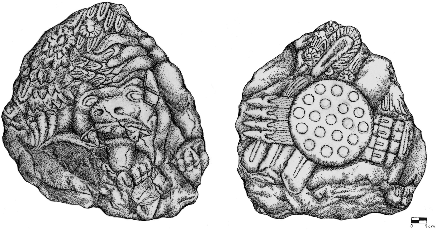
The ethnohistoric evidence of the military importance of the Valley of Atlixco is supported, not by monumental architecture or infrastructural works (Hodge Reference Hodge1998:200), but by the presence of various Late Postclassic period sculptures and carvings. One sculpture, referred to as the flowered rock (piedra floreada), is located 20 km south of Atlixco (Plunket and Uruñuela Reference Plunket, Uruñuela, Hodge and Smith1994:439). Another, called the eagle-jaguar rock (piedra águila-jaguar) (Figure 8), representative of the eagle-jaguar warriors of the Triple Alliance, is located on the south side of Huaquechula's zócalo. On the flowered rock are carved symbols of Camaxtli, god of the Huexotzincas and Tlaxcaltecas and, on the eagle-jaguar rock, a heron-feather decoration (aztaxelli) characteristic of Tezcatlipoca, one of the most important gods of the Triple Alliance (Plunket and Uruñuela Reference Plunket, Uruñuela, Evans and Webster1994:439). The symbols for warfare–water and fire (atl-tlachinolli)—carved on both sculptures lead Plunket and Uruñuela (Reference Plunket and Uruñuela1991–1992:48) to conclude that the flowered rock marked the southern limit of the independent polity of Huexotzinco and the eagle-jaguar rock the northern limit of Triple Alliance conquests—Cuauhquechollan.
Eagle-jaguar rock (piedra águila-jaguar), south side of Huaquechula's zócalo.
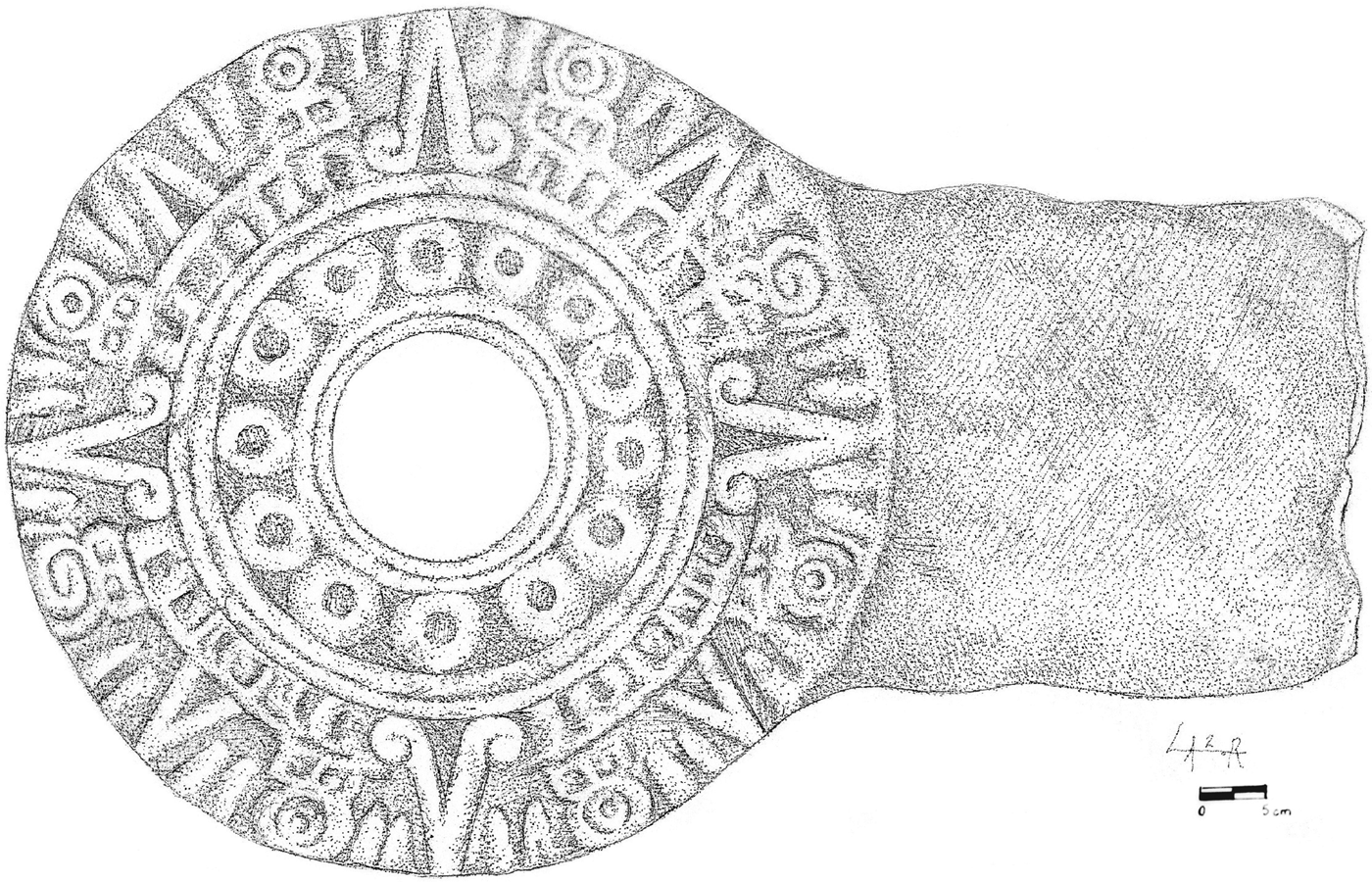
Boundaries between pre-Columbian polities also could be marked by ball courts (Gillespie Reference Gillespie, Scarborough and Wilcox1991:341) on which the Mesoamerican ball game was played. Thus, further support for the division of the Valley of Atlixco into north and south is suggested by the two stone goal-markers found in Huaquechula. One is embedded in the north wall of the ex-convent (Figure 9); the other is housed in the Regional Museum of Puebla (Figure 10). On each is carved a solar disc depicting both solar rays and the four cardinal directions, reminiscent of the Aztec calendar stone. Because the frequency of ball courts is higher in decentralized than in centralized political systems (Santley et al. Reference Santley, Berman, Alexander, Scarborough and Wilcox1991:17), a ball court might have been built immediately after Cuauhquechollan was relocated in a.d. 1443, when competition for land and tribute between it and its enemies, Calpan and Huexotzinco, were at its height. Alternatively, one might have been built after the Triple Alliance incorporated Cuauhquechollan into the tributary province of Tepeacac in a.d. 1467. No ball courts, however, are depicted in the early colonial period pictorials that the Cuauhquechultecas created nor, to date, have any been found in the Valley of Atlixco, which suggests that the two goal-markers served as symbolic acknowledgment of the extent of Triple Alliance rule.
Goal marker, north wall of ex-Franciscan convent.
Goal marker, Regional Museum of Puebla.
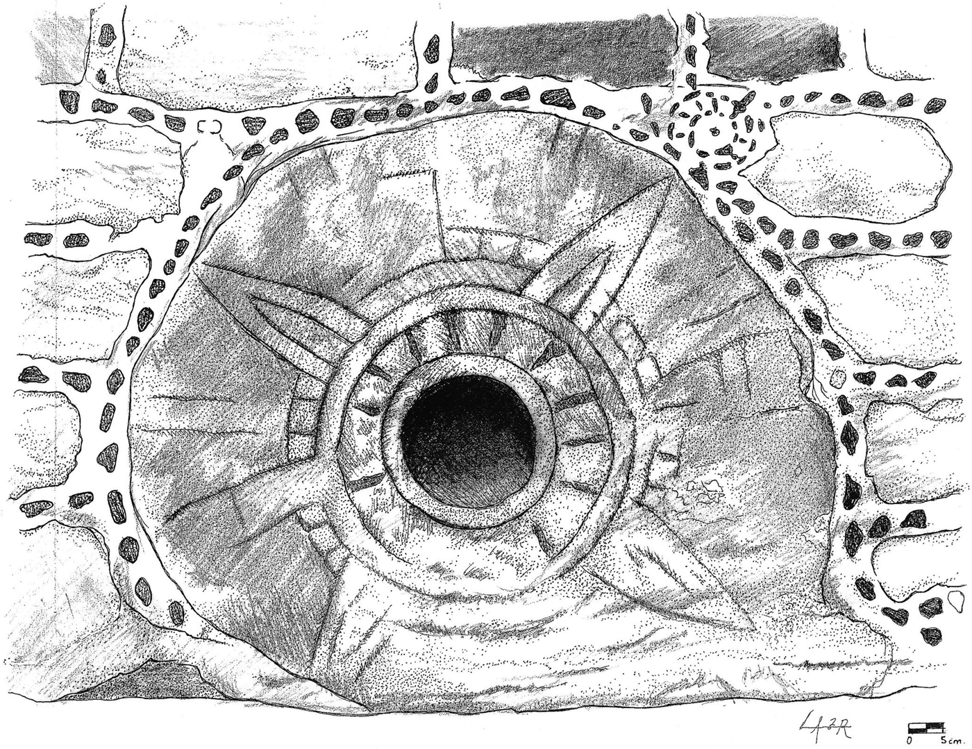
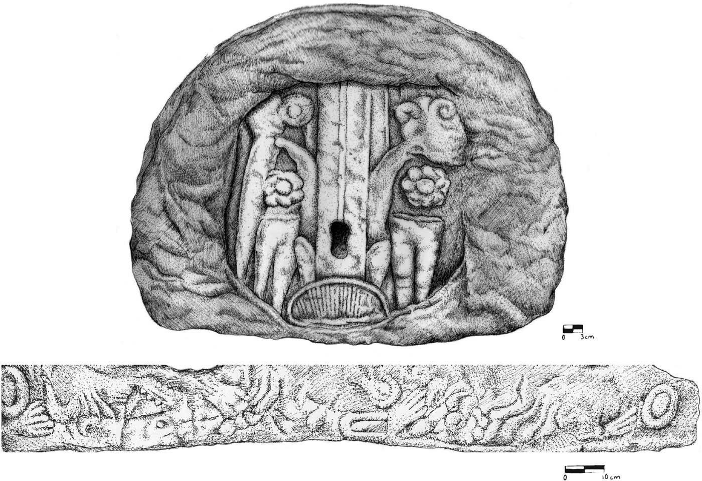
Evidence of the military importance of Cuauhquechollan, itself, appears on several other sculptures and carvings (Morales Cano Reference Morales Cano and Cano2009). One, housed in the Regional Museum of Puebla, is a gladiatorial disc (temalacatl) to which were tied captives of war, armed only with mock weapons to do battle against fully armed Triple Alliance soldiers (Figure 11). On each face is carved a solar disc; greenstones (chalchihuites), symbolic of “precious water” (blood); a butterfly, possibly symbolic of Itzpapalotl, goddess of sacrifice; and a human ear pierced with a maguey spine, symbolic of autosacrifice. The second—a carving embedded in the north wall of the ex-Franciscan convent—represents the sacred vessel (cuauhxicalli) in which the hearts of human sacrifices were placed (Figure 12). In the center, a reed emerges from a ball of grass in which maguey spines were kept. On the top right is a human heart; to the left is a sharpened bone, also used as a piercing instrument in autosacrifice. What appear to be two maguey spines are on each side. On the border of the carving are greenstones and a pair of human hands which appear to be supporting a serpent. That piercing instruments were depicted on both the temalálcatl and the cuauhxicalli seems to conform to the goals of autosacrifice—“to obtain something [success on the battlefield] or to give thanks [for gaining captives for sacrifice]” (Graulich Reference Graulich2005:318).
Gladiatorial disc (temalacatl), Regional Museum of Puebla.
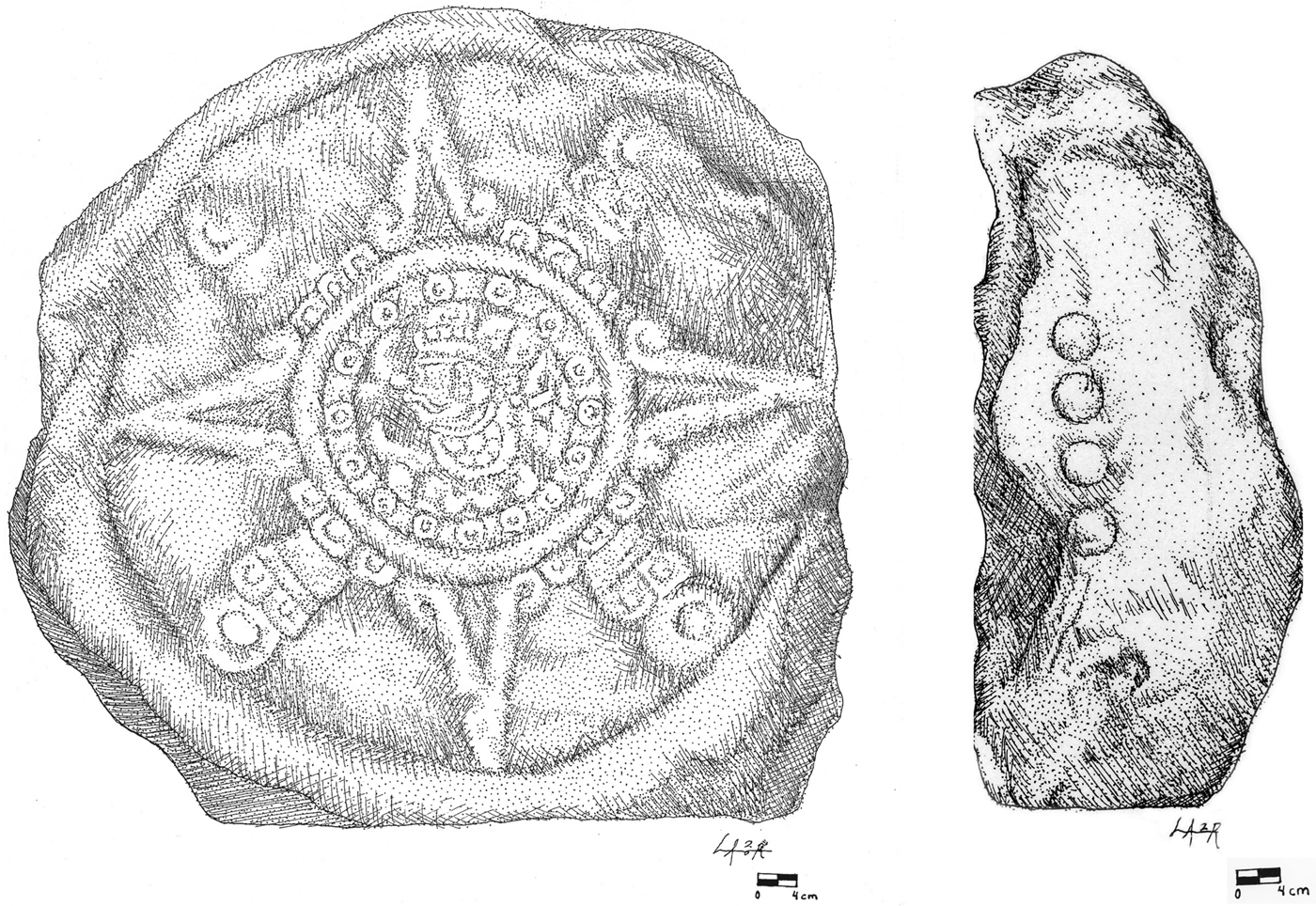
Solar disc, south side of Huaquechula's zócalo.
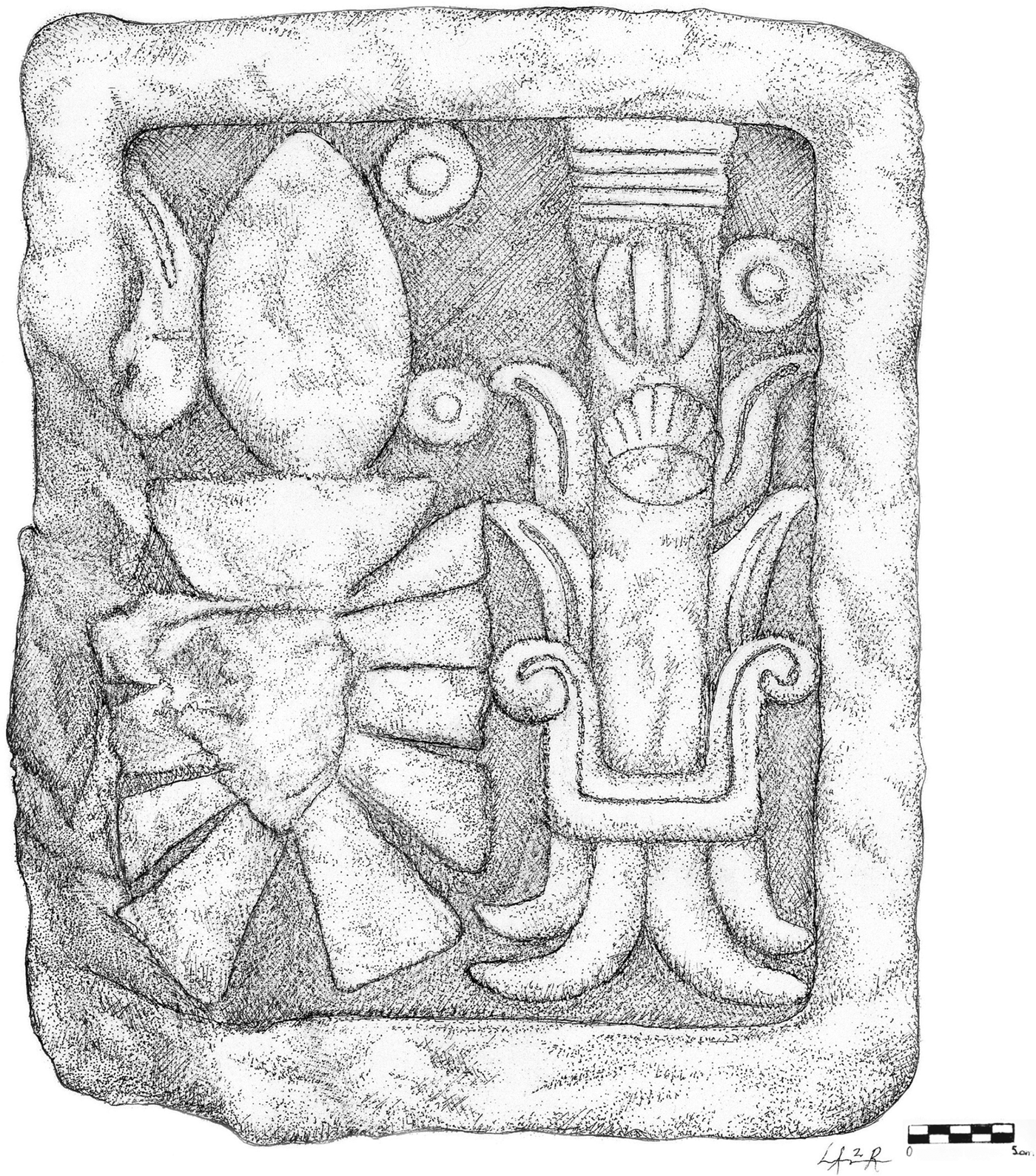
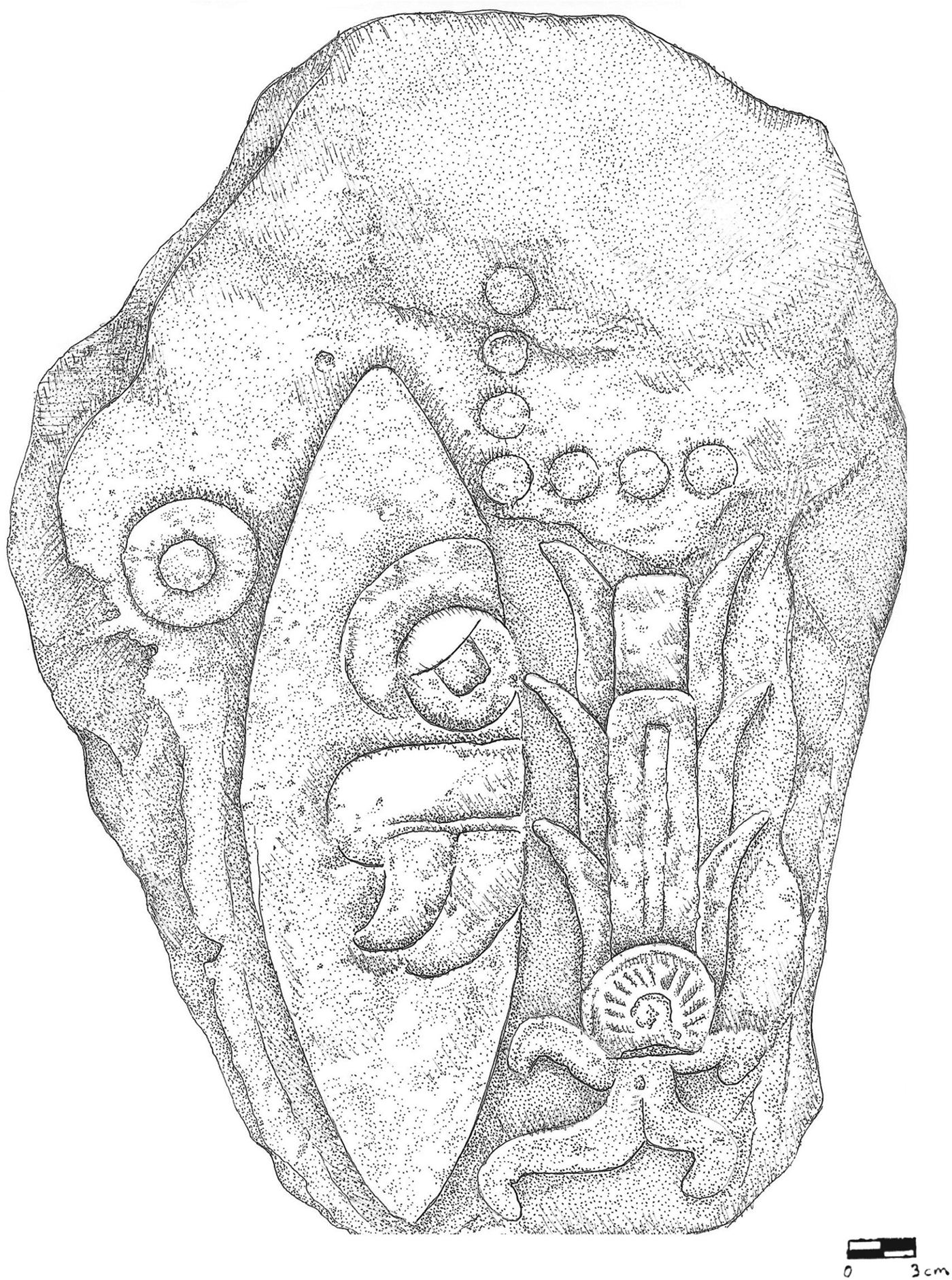
The third sculpture (Figure 13), located on the south side of Huaquechula's zócalo, is a cylindrical stone on which is carved a solar disc. In the center of the disc is carved an image possibly of Tonatiuh, patron god of soldiers (Plunket and Uruñuela Reference Plunket and Uruñuela1991–1992:38), wearing a feathered headdress and ear guards (Morales Cano Reference Morales Cano and Cano2009:35). On the rim of the sculpture are carved four small circles that once formed part of a date-glyph. Even more intriguing are two pieces on which the date-glyphs remain intact. The first (Figure 14), discovered after part of the south wall of the ex-convent collapsed, bears the glyphs 2 tecpatl 1 acatl; the second (Figure 15), now located in the southwest corner of Huaquechula's zócalo, bears those of 1 tecpatl 7 acatl. Based on Caso (Reference Caso, Ekholm and Bernal1971:Table 5), the glyphs might correspond to the Julian calendar-years of a.d. 1468 and a.d. 1467, in the first case, and a.d. 1480 and a.d. 1499, in the second. However, without knowledge of the context in which these pieces were carved, the significance of the dates remains uncertain.
Sacred vessel (cuauhxicalli), north wall of ex-Franciscan convent.
Date glyph (2 tecpatl 1 acatl), south wall of ex-Franciscan convent.
Date glyph (1 tecpatl 7 acatl), southwest corner of Huaquechula's zócalo.
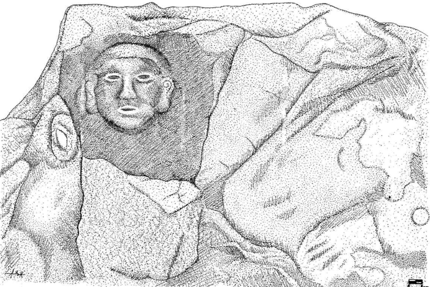
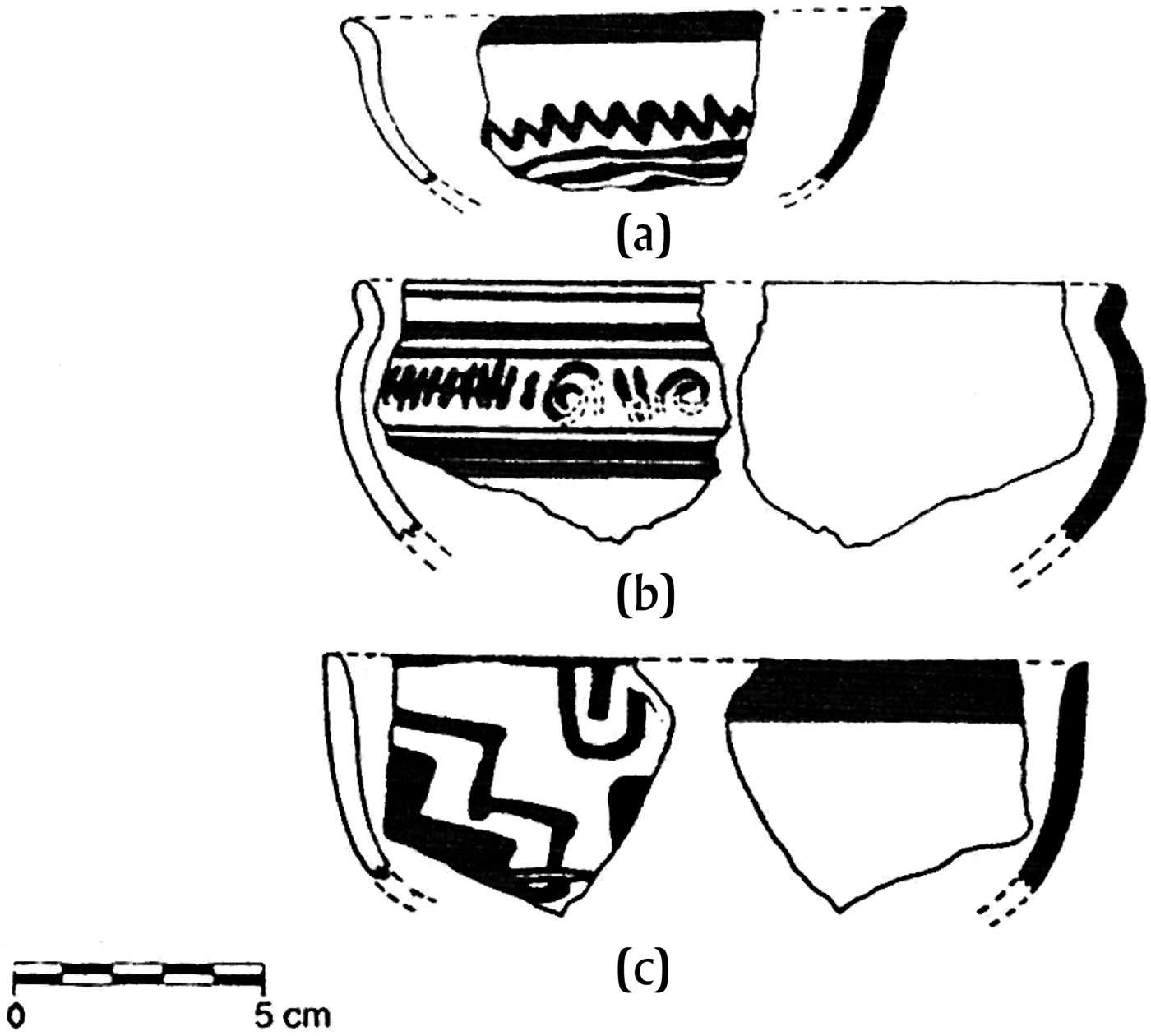
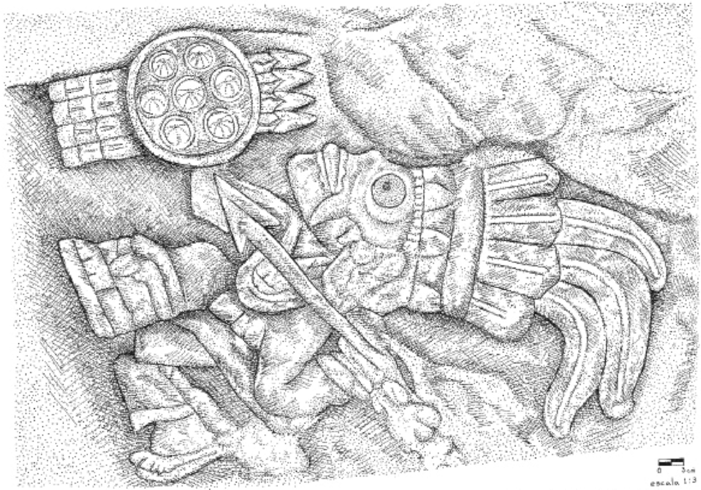
Although the Valley of Atlixco was of military importance to the Triple Alliance, both the archaeological and the iconographic evidence suggest that this did not prevent it from maintaining or developing relationships with other regions. Morales Cano (Reference Morales Cano1991:90–91) noted certain similarities between ceramics from test pits in AT–12 (Figure 16) and the Yanhuitlan Cream and Red-on-Cream from the Mixteca Alta (Spores Reference Spores1972:26, 30–32). Plunket (Reference Plunket1990:14) also had noted certain similarities between the Black-on-Cream ware from Cuauhquechollan and the Fine Cream ware from the Mixteca Alta. Further archaeological research into this issue would complement studies done on the socioeconomic and political relationships between the Mixteca Alta and the Eastern Nahua (Pohl Reference Pohl, Smith and Berdan2003a, Reference Pohl, Smith and Berdan2003b, Reference Pohl, Smith and Berdan2003c), on the one hand, and the Nonoalca Chichimecas (Cepeda Cárdenas Reference Cepeda Cárdenas and de la Lama1997)—who disappear from the ethnohistoric sources—on the other. The possible relationship between Cuauhquechollan and the Mixteca Alta also appears in a carving on the north wall of the ex-convent, which depicts an image of Mixcoatl (Figure 17) in a local expression of the Mixteca-Puebla style (Leonardo López Luján, personal communication 2010). In fact, the image of Mixcoatl—not only similar to the Mixtec figure, 4 Jaguar (Pohl Reference Pohl, Smith and Berdan2003a:65), but one and the same as Camaxtli, the god of Huexotzinco and Tlaxcallan—is suggestive of where the loyalties of Cuauhquechollan may have come to lie. When the Spaniards arrived in a.d. 1520, they learned that the Tlaxcaltecas and the Cuauhquecholtecas were “friends and confederates” (Vázquez de Tapia Reference Vázquez de Tapia1972:36), both of whom assisted them in re-taking Cuauhquechollan from the Mexica soldiers who occupied it (Cortés Reference Cortés1993:89–92). From a.d. 1512 to a.d. 1520, however, the sources are silent on Cuauhquechollan and the remainder of the history of the Late Postclassic period belongs to the Triple Alliance, Huexotzinco, and Tlaxcallan.
Yanhuitlan-type ceramics: (a) to (c).
Mixcoatl, north wall of ex-Franciscan convent.
SUMMARY AND CONCLUSION
By reviewing the ethnohistoric sources in light of recent archaeological and iconographic findings from the sites of Atlixco and Cuauhquechollan, this paper broadly illustrates the commercial, economic, and military importance of the Valley of Atlixco to the history of Mesoamerica. Atlixco—the settlement referred to as Cuauhquechollan—was occupied from the Early Preclassic period to the middle of the Late Posclassic period (a.d. 1443), when it was relocated 20 km to the southwest. This new settlement retained the name, Cuauhquechollan (present-day Huaquechula), while Atlixco became referred to as Old Cuauhquechollan.
For the Preclassic period, the archaeological evidence suggests the commercial and economic importance of the site of Atlixco (the original settlement of Cuauhquechollan). Ceramic ware, such as the diagnostic Negro Pulido that reflects the influence of Zohapilco (Lake Chalco), suggests that the site was located on or near a trade route between the basin of Mexico and the Gulf Coast. Its dispersed settlement pattern on fertile lands to the south and southeast of Cerro San Miguel also suggests that it supplied agricultural products to other, larger sites in the valley. During the Classic period, the settlement pattern of Atlixco shifted to the northeast, possibly to take better advantage of trade along the Teotihuacan Corridor. The ceramic assemblages of both Hacienda San Lorenzo and Atlixco reflect the influence of Teotihuacan. For the Epiclassic period, when the ethnohistoric sources discuss the arrival of the Olmeca Xicalancas in the Puebla-Tlaxcala Valley, the settlement pattern of Atlixco shifted again to what might have been a defensive location to the northwest of Cerro San Miguel where monumental architecture began to be constructed. From that point, Atlixco would become a densely populated settlement, occupied continuously from the Epiclassic period to the middle of the Late Postclassic period when it was relocated 20 km to the southwest.
For the Early and Middle Postclassic periods, the ethnohistoric sources are rich in the ideational aspects of population movements and political developments, few of which correlate with the archaeological evidence. For the Early Postclassic period, neither the migrations of named ethnic groups—such as the Tolteca Chichimecas and the Nonoalca Chichimecas—associated with the abandonment of Tollan, nor the mythical flight of Quetzalcoatl appears directly in the archaeological register. However, the arrival of new groups in the Valley of Atlixco seems to be supported by the appearance of two diagnostic ceramic types—Atlixco Bruñido and Monócroma Incisa—that reflect the influence of both the basin of Mexico and Cholula. For the Middle Postclassic period, the ethnohistoric details of the closer relationship that developed between the basin of Mexico and the Valley of Atlixco, and the initial conflict between Cuauhquechollan and its enemies, Calpan and Huexotzinco foreshadow the increasing economic and military importance of the Valley of Atlixco in the Late Postclassic period. Neither, however, appears in the archaeological—and, specifically, the ceramic—evidence, although it seems clear that the settlement pattern of Cuauhquechollan did not change at this time.
For the Late Postclassic period, the abundance of ethnohistoric evidence of the increasing commercial, economic, and military importance of the Valley of Atlixco cannot always be correlated with the archaeological evidence. Due to rapid economic development around the present city of Atlixco, for example, the archaeological evidence for the abandonment of the site in a.d. 1443 and its reoccupation by tenant farmers from Huexotzinco is unclear, and contemporary interpretations of the ethnohistoric sources do little to clarify the issue. However, the relocation of the Cuauhquecholtecas is supported by the appearance of a new, Late Postclassic period settlement 20 km southwest of Atlixco. Ceramic ware reflecting the influence of the basin of Mexico was found in surface surveys carried out around the present town of Huaquechula. More difficult to discern archaeologically is the location of the defensive wall that surrounded the settlement, noted by Cortés and depicted in several early colonial period pictorials. After Cuauhquechollan became part of the tributary province of Tepeacac in a.d. 1467, its economic, military, and commercial importance reappears in the ethnohistoric sources. Not only did it supply staple crops and captives of war to the Triple Alliance, but several early colonial period pictorials indicate the presence of marketplaces in both Old Cuauhquechollan and Cuauhquechollan. Cuauhquechollan's commercial importance is further supported by a viceregal licence that was awarded to its pochteca to continue to engage in long-distance trade to the southeast. The ethnohistoric sources also make clear that Cuauhquechollan's new location allowed Triple Alliance soldiers easy access to the plains on which they waged battles against the enemy polities of Huexotzinco, Tlaxcallan, and Cholollan.
If the ethnohistoric details of the Valley of Atlixco's military importance to the Triple Alliance are preserved only in part in the archaeological record, they are supported, again in part, by the iconographic evidence. The piedra floreada and the piedra águila-jaguar might have marked the boundaries between the independent polities of Huexotzinco and Cuauhquechollan, and the two goal-markers, if they did not mark actual boundaries, might have served as a symbolic acknowledgment of the extent of Triple Alliance rule. The symbolism of the temalálcatl, the cuauhxicalli, and the solar disc bearing the image of Tonatiuh clearly allude to warfare. Unfortunately, the symbolism of the sculpture and the carving that bear the date-glyphs 2 tecpatl 1 acatl and 1 tecpatl 7 acatl, respectively, is unclear. However, the image of Mixcoatl carved in a local Mixteca-Puebla style speaks to Cuauhquechollan's possible relationship to the independent polities of Huexotzinco and Tlaxcallan—with which the Cuauhquecholtecas were allied—and to the Mixteca Alta. In Old Cuauhquechollan and, possibly, in Cuauhquechollan as well, ceramic types similar to those of the Mixteca Alta offer archaeological evidence of a possible relationship with that region.
In conclusion, despite some difficulty in correlating the ethnohistoric, archaeological, and iconographic evidence, there appears to be a sufficient amount of overlap to allow for a better understanding of the pre-Columbian history of the Valley of Atlixco than would the use of only one source. However, more research needs to be done. For example, although Asselbergs (Reference Asselbergs2004) offers a detailed interpretation of the Lienzo de Cuauhquechollan, her preliminary interpretations of the other early colonial period pictorials created by the Cuauhquecholtecas should be expanded upon. Not only would this allow for a better understanding of their history as they, themselves, perceived it, but it also might assist in locating other archaeological sites in the Valley of Atlixco. Even more pressing is the need for additional archaeological research. First, because of the detrimental effects of natural erosion and human activity, the monumental structures to the northwest of Cerro San Miguel, as well as the possible location of the wall that surrounded Cuauhquechollan, should be examined as soon and as thoroughly as possible. Second, additional surface surveys as well as full-scale excavations should be carried out in both Atlixco and Huaquechula. Such work would contribute to the refinement of the ceramic chronology of the Valley of Atlixco which, to date, is incomplete. It also would allow for a closer comparison of the ceramic materials from Atlixco and Cuauhquechollan with those of surrounding regions, such as the basin of Mexico, the wider Valley of Puebla-Tlaxcala, and the Mixteca Alta, in order to clarify the relationships between them. Finally, expert iconographic analysis of the Late Postclassic sculptures and carvings located in and around present-day Huaquechula would serve to clarify those relationships even further.
RESUMEN
A pesar de la importancia comercial, económica y militar del valle de Atlixco en la historia de Mesoamérica, no ha recibido la atención que merece por parte de los etnohistoriadores y arqueólogos. Este trabajo ilustra esa importancia por medio de una correlación de distintos tipos de evidencias de los sitios de Atlixco y Cuauhquechollan. Atlixco—el asentimiento denominado en las fuentes etnohistóricas mencionan Cuauhquechollan—fue ocupado de forma continua desde el período preclásico temprano hasta mitad del período posclásico tardío (1443 d.C.), cuando fue relocalizado a 20 km hacia el suroeste (actual Huaquechula). El nuevo asentamiento mantuvo el nombre de Cuauhquechollan, mientras al de Atlixco se le denominó Huehuecuauhquechollan (Cuauhquechollan la Vieja). Lass evidencia consisten en una variedad de fuentes etnohistóricas, el registro arqueológico (los patrones de asentamiento y materiales cerámicos) y la iconografía de las esculturas y relieves del período posclásico tardío, localizados en los alrededores de Huaquechula y en las inmediaciones del valle de Atlixco. A pesar de las limitaciones de los diferentes tipos de evidencias, los resultados sugieren que hay suficientes puntos de coincidencia que permiten una mejor comprensión de la importancia del valle de Atlixco e proporcionan el impulso para futuras investigaciones.
ACKNOWLEDGMENTS
The authors would like to thank Frederick Hicks and two anonymous reviewers for Ancient Mesoamerica, as well as Janice Drodge, for their helpful suggestions regarding the organization and content of this article, and Leonardo López Luján for his insights into the carving of Mixcoatl. We would also like to thank Tyson Chen for creating the maps, and Cynthia Torres and Luis Roberto Rodríguez Aguilar for producing the drawings of the ceramic materials, and the sculptures and carvings, respectively.