Introduction
Although species extinction is a natural evolutionary process (De Vos et al. Reference De Vos, Joppa, Gittleman, Stephens and Pimm2015), the impact of anthropogenic activities, particularly in the context of climate change, has significantly accelerated its rate (Ceballos et al. Reference Ceballos, García and Ehrlich2010). The loss of vegetation cover and habitat fragmentation are currently among the main threats to biodiversity (Haddad et al. Reference Haddad, Brudvig, Clobert, Davies, Gonzalez and Holt2015). To address this scenario, it is essential to first understand the conservation status of species by collecting data on their distribution (Alves et al. Reference Alves, Pimm, Storni, Raposo, Brooke and Harris2008; Hermoso et al. Reference Hermoso, Kennard and Linke2015; Rondinini et al. Reference Rondinini, Wilson, Boitani, Grantham and Possingham2006), habitat availability (Paton and Matthiopoulos Reference Paton and Matthiopoulos2016), and population trends (Thogmartin et al. Reference Thogmartin, Howe, James, Jhonson, Reed and Sauer2006), and assess how their environment has been changing. In Brazil, we can highlight the silent disappearance of the Kinglet Calyptura Calyptura cristata and the Rio de Janeiro Antwren Myrmotherula fluminensis. These two bird species may already have gone extinct, leaving no reliable records of their ecology or distribution (Lees and Pimm Reference Lees and Pimm2015).
The Black-footed Antwren Formicivora erythronotos Hartlaub (Reference Hartlaub1852) is an endemic bird of the Atlantic Forest, from the lowland forests of the state of Rio de Janeiro (Figure 1), with its distribution restricted to the Costa Verde region, between the municipalities of Paraty and Angra dos Reis (Sullivan et al. Reference Sullivan, Wood, Iliff, Bonney, Fink and Kelling2009). During the past century, the bird was known only from specimens deposited in museums and went unrecorded for more than 100 years (Wikiaves 2025). However, it was rediscovered in 1987 when some birdwatchers made the first official record of it in the wild (Pacheco Reference Pacheco1988). Since then, the species was included in the Brazilian Red List, but no effective conservation measures have been taken (Gonzaga Reference Gonzaga2008). Except for a few surveys on territory and some additional sightings, little is known about the species, as these findings have generally not been published in scientific journals. Knowledge about the species is limited to its description, reproductive biology (Mendonça Reference Mendonça2001), and a few details about its behavior and distribution (Tobias and Williams Reference Tobias and Williams1996).
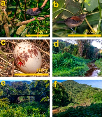
(a) Male and (b) female Black-hooded Antwren Formicivora erythronotos, respectively; c) an abandoned nest with an egg of this species with a perforation in the shell (red arrow); d), e) and f) foreground of the photographs showing the type of environment where the species occurs, avoiding mature forest and preferring disturbed secondary forests, in Costa Verde region, Rio de Janeiro state, Brazil.
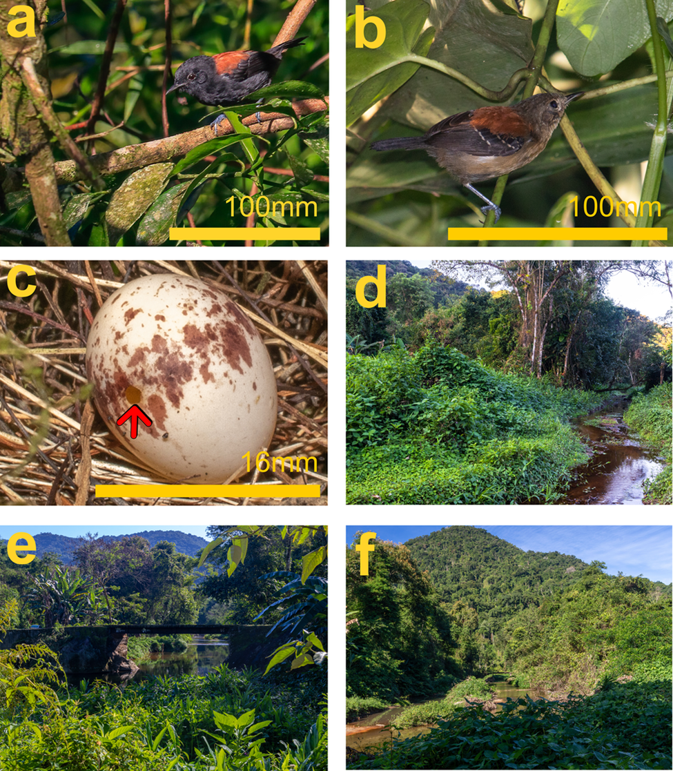
Figure 1. Long description
A multi-panel figure containing six photographs labeled a through f in the top-left corners.
Panel a: A male Black-hooded Antwren with black plumage and a reddish-brown back perched on a branch. A yellow scale bar at the bottom right indicates 100 mm.
Panel b: A female Black-hooded Antwren with lighter brown and buff-colored plumage perched among green leaves. A yellow scale bar at the bottom right indicates 100 mm.
Panel c: A close-up of a white egg with brown speckles resting in a nest of dry grass. A red arrow points to a small circular perforation on the left side of the shell. A yellow scale bar at the bottom right indicates 16 mm.
Panel d: A landscape view of a narrow stream bordered by dense, low-lying green vegetation and secondary forest trees under a bright sky.
Panel e: A view of a small stone bridge crossing a stream, surrounded by lush tropical greenery and forested hills in the background.
Panel f: A wide shot of a valley with a stream winding through thick secondary forest, leading toward a large, tree-covered hill under a clear blue sky.
The species occurs only on the southern coast of Rio de Janeiro, where historical records indicate its presence in two main populations (Mendonça Reference Mendonça2001), one in the Ariró valley (Angra dos Reis, RJ) and another in the Mambucaba valley (on the border between Angra dos Reis and Paraty, Rio de Janeiro), as well as in other valleys of the region (ICMBio 2018). The only population information available for the population species consists of density estimates of 156 pairs km-2 in Mambucaba and 89 pairs km-2 in Ariró (Mendonça Reference Mendonça2001). However, in recent years, insights from research, birdwatchers, and environmental officers have suggested a considerably smaller population. These density estimates have been repeated in conservation assessments, yet there is no description as to how these values were obtained. Currently, the species is classified as Endangered on the IUCN Red List (BirdLife International 2020), as Critically Endangered on the Brazilian national Red List (ICMBio 2018) and Vulnerable in the Red List from the state of Rio de Janeiro (Alves et al. Reference Alves, Pacheco, Gonzaga, Cavalcanti, Raposo, Yamashita, Bergallo, Rocha, Alves and Van Sluys2000). As the species is endemic to the state of Rio de Janeiro, its conservation status should, in principle, be the same across all of these lists. Therefore, updating data on the species and understanding the differences between these classifications are essential.
Locating the populations and assessing the conservation status and genetic variability of the Black-hooded Antwren are among the actions outlined in the Atlantic Forest Birds National Action Plan (PAN Aves da Mata Atlântica), and represent key information to support conservation efforts. The IUCN Red List (IUCN 2024), the primary global reference for biodiversity threat assessment, employs criteria such as population density, Extent of Occurrence (EOO), and Area of Occupancy (AOO) to classify a species’s conservation status. Until now, data on this species have not been published in peer-reviewed articles, and almost all available information is based on indirect analyses. This current study aimed to systematically collect field data related to distribution, estimate density, and evaluate the conservation status of this species. The specific aims were: a) to map the updated occurrence of the species; b) to use the distribution data in addition to landscape analysis to calculate the EOO and AOO of the Black-hooded Antwren (IUCN 2024); c) to calculate the species density and d) to reassess its conservation status and make recommendations to update the IUCN status.
Methods
Extent of Occurrence (EOO) and Area of Occupancy (AOO)
Surveys were conducted primarily in Mambucaba and Ariró valleys. The objective was to investigate the distributional limits of the species and assess its potential occurrence in adjacent valleys within the region. Due to access constraints, exploratory efforts were conducted opportunistically, prioritising lowland forest habitats, accessible valleys, and established trails. Additionally, during the study period, occurrence records from citizen science platforms (Wikiaves, iNaturalist, eBird) were monitored, and communication was maintained with local birdwatchers, for whom the species represents a notable point of interest. During the study, a remarkable record of the species was made very far from its known range, in Rio Claro, Rio de Janeiro municipality, where a male was photographed within the limits of the Cunhambebe State Park. Consequently, we included that area in our sampling.
Surveys were conducted between 2023 and 2025 using a point count method with a 100 m radius at a minimum distance of 200 m (Figure 2). Due to the species’ rarity, small territory size, and territorial behavior, we employed a five-minute playback period followed by five minutes of silent observation, following Mattos et al. (Reference Mattos, Vale, Vecchi and Alves2009). To minimise issues related to pseudo-absences, each point was surveyed three or four times, except for locations deemed unsuitable for the species, such as mangroves or highly urbanised areas, or those that could not be revisited, such as private properties. In total, we surveyed 229 points across 15 localities (Table 1, Supplementary materials Table S1). After that, we tested the detectability of the point counts by a hierarchical multiscale occupancy model (Nichols et al. Reference Nichols, Bailey, ’Conell, Talancy, Grant and Gilbert2008), which separates locality occupancy, point use, and detection. The model was fitted in JAGS via the jagsUI package (Kellner Reference Kellner2024) without covariates, and the analysis was conducted in RStudio (Version 2023.09.1).
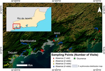
The 229 counting points of the study and the three valleys where the Formicivora erythronotos was recorded, in the Costa Verde region, Rio de Janeiro state, Brazil. The points with just one visit were deemed unsuitable for the species (mangroves or highly urbanised areas).
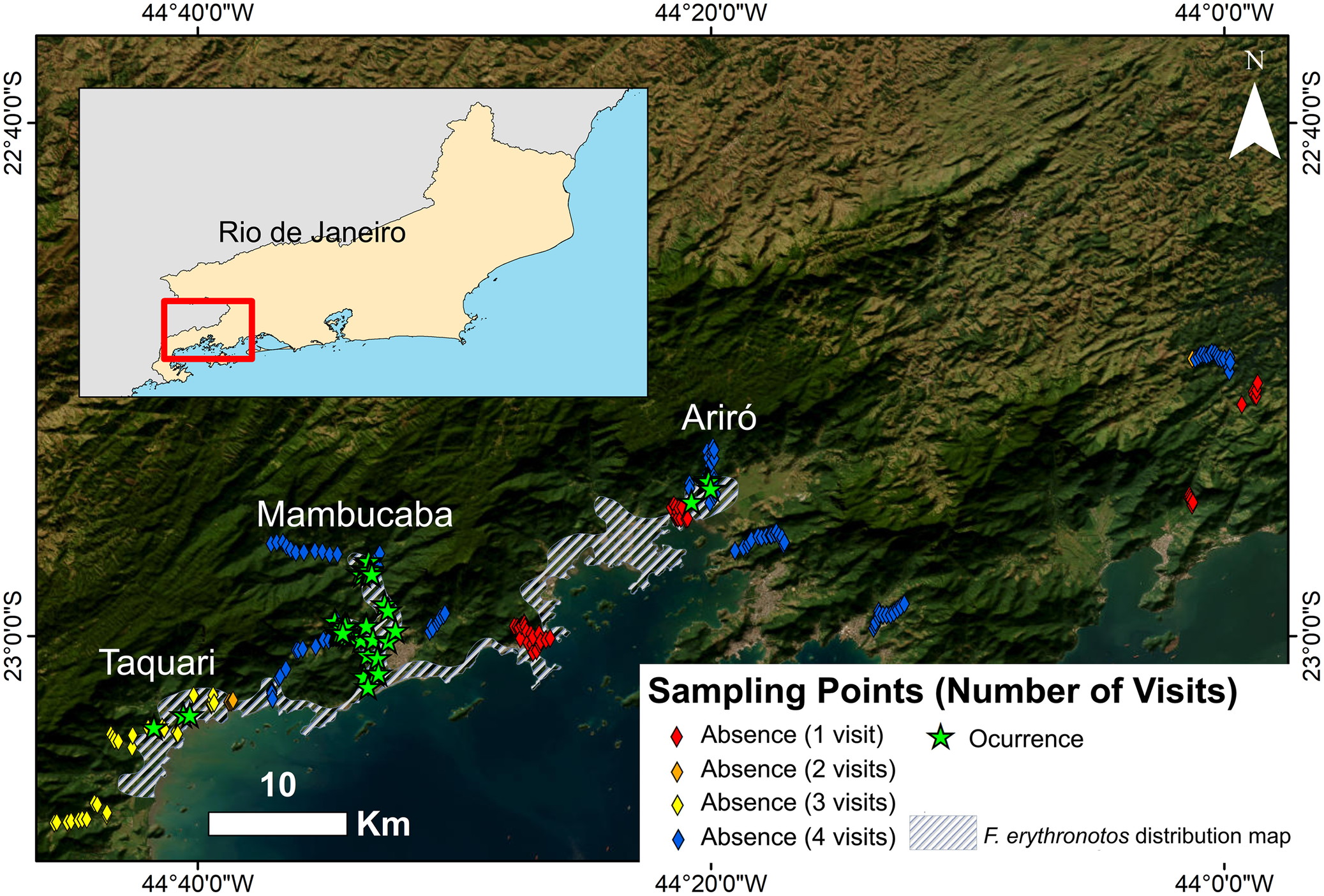
Figure 2. Long description
A multi-panel map set against a satellite imagery background of forested coastal mountains.
* Inset Map: Located in the top-left, showing the state of Rio de Janeiro with a red rectangle highlighting the study area on the southern coast.
* Main Map: Displays the Costa Verde coastline. Three specific valleys are labeled from West to East: Taquari, Mambucaba, and Ariró.
* Data Distribution:
- Green stars indicating Occurrence are concentrated primarily in the Mambucaba valley and sparsely in Taquari and Ariró.
- Blue diamonds indicating Absence with 4 visits are clustered along the upper reaches of the valleys.
- Red and yellow diamonds indicating Absence with 1 to 3 visits are scattered along the coastal fringe and lower elevations.
- A grey hatched pattern represents the F. erythronotos distribution map, covering the coastal lowlands between the valleys.
* Map Features:
- A North arrow is in the top-right.
- A scale bar indicating 10 K m is in the bottom-left.
- Coordinate grid lines mark 44 degrees 40 minutes 0 seconds W, 44 degrees 20 minutes 0 seconds W, and 44 degrees 0 minutes 0 seconds W on the X-axis, and 22 degrees 40 minutes 0 seconds S and 23 degrees 0 minutes 0 seconds S on the Y-axis.
* Legend: Titled Sampling Points Number of Visits, it defines symbols for Absence 1 visit red diamond, 2 visits orange diamond, 3 visits yellow diamond, and 4 visits blue diamond. A green star represents Occurrence, and the hatched area represents the species distribution map.
The 229 counting points conducted during the study on Formicivora erythronotos, at Costa Verde region, Rio de Janeiro state, Brazil, separated by the name of the regions and number of surveys performed
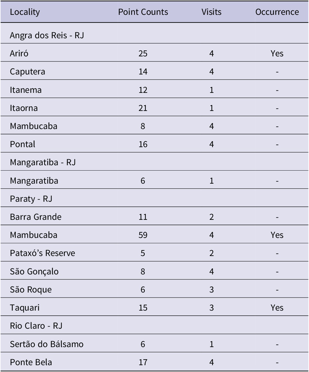
Table 1. Long description
The table consists of four columns: Locality, Point Counts, Visits, and Occurrence.
* Angra dos Reis - R J:
- Ariró: 25 point counts, 4 visits, Occurrence: Yes.
- Caputera: 14 point counts, 4 visits, Occurrence: -.
- Itanema: 12 point counts, 1 visit, Occurrence: -.
- Itaorna: 21 point counts, 1 visit, Occurrence: -.
- Mambucaba: 8 point counts, 4 visits, Occurrence: -.
- Pontal: 16 point counts, 4 visits, Occurrence: -.
* Mangaratiba - R J:
- Mangaratiba: 6 point counts, 1 visit, Occurrence: -.
* Paraty - R J:
- Barra Grande: 11 point counts, 2 visits, Occurrence: -.
- Mambucaba: 59 point counts, 4 visits, Occurrence: Yes.
- Pataxó’s Reserve: 5 point counts, 2 visits, Occurrence: -.
- São Gonçalo: 8 point counts, 4 visits, Occurrence: -.
- São Roque: 6 point counts, 3 visits, Occurrence: -.
- Taquari: 15 point counts, 3 visits, Occurrence: Yes.
* Rio Claro - R J:
- Sertão do Bálsamo: 6 point counts, 1 visit, Occurrence: -.
- Ponte Bela: 17 point counts, 4 visits, Occurrence: -.
All the following analyses were conducted in ArcGIS Desktop 10.8 (Version 10.7.0.10450). To calculate the EOO and AOO of the Black-hooded Antwren, we followed the IUCN criteria (IUCN 2024). To calculate the EOO, we applied the minimum convex polygon to our occurrence points. For the AOO, we plot the recorded occurrence points using 2 km x 2 km grids on the original IUCN geographic range polygon, and count the grids where the species occur. To calculate the available habitat, we used the land use and land cover maps of Brazil, Collection 8, with a spatial resolution of 30 m, available in Mapbiomas (Souza et al. Reference Souza, Shimbo, Rosa, Parente, Alencar and Rudorff2020). The available habitat was calculated considering all native vegetation present (categories 3, 4, 11, and 49 in the raster), except for mangroves, which occur in the region but are unsuitable for the species.
To obtain a map of available vegetation cover for the species, we used a binary raster derived from a habitat suitability model for the Black-hooded Antwren carried out by our research group and clipped it using the geographic range polygon of the species, available on the IUCN website. We converted the raster to a shapefile and used the resulting polygon to clip the most recent land cover raster (2023), which was then used for all subsequent measures of available area for the species. Henceforward, it will be referred to as HabitatRaster (Supplementary materials, File S1).
We considered two types of vegetation cover: the ample cover (AC) and narrow cover (NC). The ample cover was obtained by considering all native vegetation, and summing the following categories from the raster: 3 (Forest Formation); 4 (Savanna Formation); 11 (Wetlands); and 49 (Wooded Sandbank Vegetation). But as the species avoids slopes and mature forests and shows a preference for disturbed secondary forests and regenerating areas, which correspond precisely to the Wooded Sandbank Vegetation category of the raster. As this may represent a habitat associated specifically with the species, we considered the narrow cover as the sum of this category.
Additionally, we calculated the extent of available vegetation cover within the AOO and within the valleys with confirmed species occurrences. Using the habitat suitability map, the IUCN distribution map, and satellite imagery, we manually delineated four polygons that encompassed vegetated areas inside the valleys where the species was recorded (Figure 3, Supplementary Materials, Files S2, S3, S4 and S5): two in Mambucaba (Chapéu do Sol waterfall and Fortaleza farm), one in Taquari, and another in Ariró. As the Black-hooded Antwren is a specialist in lowland forests and appears to avoid slopes, the polygons were manually drawn to encompass the valleys and their contiguous areas, while preventing hillsides. Then we used these polygons to clip the HabitatRaster and extract the area of available vegetation, based on the AC and NC.
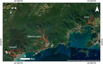
Polygons used to calculate available vegetation cover in Mambucaba (Chapéu do Sol waterfall - 1 and Fortaleza farm - 2), Taquari and Ariró, in the Costa Verde region, RJ, Brazil.
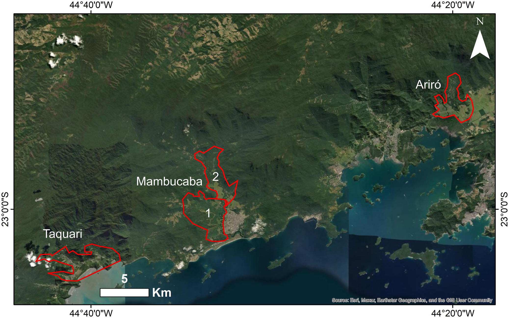
Figure 3. Long description
A satellite map displays a coastal region with dense green vegetation and mountainous terrain. Four specific study areas are outlined in red.
* In the Southwest is the Taquari polygon, an irregular shape near the coastline.
* In the center is the Mambucaba region, containing two adjacent polygons. Polygon 1 is the southern section near the Chapéu do Sol waterfall, and Polygon 2 is the northern section near Fortaleza farm.
* In the Northeast is the Ariró polygon, situated further inland within a mountainous area.
The map includes a North arrow in the top right corner and a 5 K m scale bar in the bottom left. Geographic coordinates mark the edges: 44 degrees 40 minutes 0 seconds West and 44 degrees 20 minutes 0 seconds West on the horizontal axis, and 23 degrees 0 minutes 0 seconds South on the vertical axis.
To estimate vegetation loss over the past two decades within the area where the Black-hooded Antwren occurs, we used land cover maps of Brazil for 2004, 2014, and 2024 and analysed the loss within the polygons of Mambucaba, Taquari, and Ariró. Then, we calculated the historical loss rate and projected it for the next 10 years. In this case, we do not use the HabitatRaster, but the original raster from MapBiomas.
Density
To estimate density, we employed the point-count methodology adapted from Mattos et al. (Reference Mattos, Vale, Vecchi and Alves2009). We established points at a minimum of 200 m interval through two transects. The transects were located on opposite sides of the Mambucaba River, in areas where the species is most abundant: one near the Chapéu do Sol waterfall, with nine points (0.282 km², Supplementary material, Table S2), and the other near the Fortaleza farm, with 12 points (0.376 km², Supplementary Materials, Table S2). At each point, we employed 5 minutes of playback, followed by an additional 5 minutes of silent observation, during which all individuals within a 100 m radius of the observer were recorded. The Index Point of Abundance (IPA) was calculated by dividing the total observed abundance by the number of points multiplied by the number of temporal replicates (IPA = abundance / (number of points * number of replicates)).
We used playback to improve the chances of detecting birds (Vale et al. Reference Vale, Bell, Alves and Pimm2007). As the Black-hooded Antwren has low dispersal capacity, had small and well-defined territories, and is highly vocal and aggressive in defending its territory (Mendonça Reference Mendonça2001), we expect to attract only individuals from territories near the point count and not inflate the density. This behavioral pattern also supports our use of a 100 m observation radius (Mattos et al. Reference Mattos, Vale, Vecchi and Alves2009), previously applied to a congeneric species, particularly because the sampling areas were characterised by relatively sparse vegetation.
Each point was surveyed eight times, four during the reproductive period (October to Janeiro) and four during the non-reproductive period (April/August) (Mendonça Reference Mendonça2001). Each transect was visited on different days, always starting at dawn. We compared the abundance between the reproductive and non-reproductive seasons using a paired t-test.
The density of the Black-hooded Antwren in the surveyed area was extrapolated to the available vegetation within the Fortaleza and Chapéu do Sol vegetation polygons, considering AC and NC, in order to estimate the density of individuals in Mambucaba.
Results
Extent of Occurrence (EOO) and Area of Occupancy (AOO)
We registered around 39 reproductive pairs on both sides of the Mambucaba river, three isolated pairs in Taquari, and six in Ariró, based on the counting points (Figure 2). The model estimated a mean locality occupancy probability of 30% (95% CI: 0.11–0.54), a point use probability of 45% (95% CI: 0.36–0.54), and a high detection probability of 82% (95% CI: 0.76–0.87). In addition, a further 13 pairs were recorded in Mambucaba during the samplings. One of the three pairs recorded in Taquari was isolated in a plot located in the urban matrix, while the other two were recorded for some months in a pasture field and not recorded after that. Two pairs in Ariró were recorded in the backyards of private properties near a forest fragment and maintained their territories throughout the three-year sampling period. Despite recent reported sightings, no individuals have been recorded in the Cunhambebe State Park.
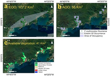
The obtained EOO polygon of the Black-hooded Antwren was 177.2 km2 (Figure 4). The AOO had an area of 55 km2 but the vegetation cover in the areas was only 16.12 km2 in the AC and 10.8 km2 in the NC (Figure 4). The total vegetation area was 41 km2 (Figure 4).
(a) the Extent of Occurrence (EOO) and (b) Area of Occupancy (AOO) of Black-hooded Antwren Formicivora erythronotos, in Costa Verde region, Rio de Janeiro state, Brazil; (c) vegetation availability in the in the EOO, based on the HabitatRaster.
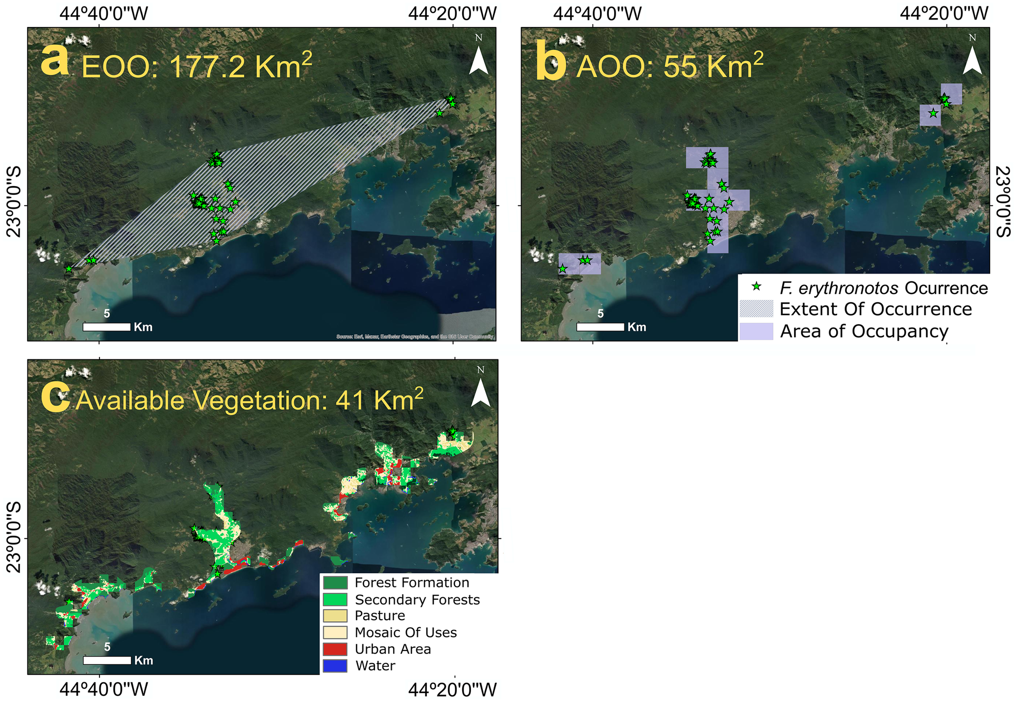
Figure 4. Long description
A three-panel satellite map series of the Costa Verde region. All maps include a North arrow and a 5 kilometer scale bar.
Panel a, top-left, titled E O O 177.2 K m squared. A diagonal, white-hatched polygon stretches from the Southwest to the Northeast, encompassing green star icons representing F. erythronotos occurrences.
Panel b, top-right, titled A O O 55 K m squared. The same green star occurrences are covered by light purple grid squares. A legend in the bottom-right identifies the green star as F. erythronotos Occurrence, the hatched area as Extent Of Occurrence, and the purple squares as Area of Occupancy.
Panel c, bottom-left, titled Available Vegetation 41 K m squared. This map overlays land-use data on the occurrence areas. A legend at the bottom-right categorizes the colors:
* Dark green for Forest Formation.
* Light green for Secondary Forests.
* Yellow for Pasture.
* Beige for Mosaic Of Uses.
* Red for Urban Area.
* Blue for Water.
The vegetation is primarily concentrated in the central and Northeastern portions of the bird’s range, with urban red patches visible along the Southern coastline.
A concept used by the IUCN in assessing conservation status is that of a ‘location’, defined as a distinct area where a single catastrophic event can affect all individuals of a taxon (IUCN 2024). The main threat to the Black-hooded Antwren is habitat loss habitat to human development (IUCN 2024), in this case taking into account the distribution we detected, we consider that the species occurs in four different locations: Aríró, Taquari and the territories of the both sides of the Mambucaba river, which undergo different land use processes, where Angra dos Reis (Fortaleza) is more urbanised, featuring the formation of small farms and small urbanisation nuclei growing within the forest, and Paraty (Chapéu do Sol) where urbanisation is less intense but pastures are mostly common.
Density
The density during the reproductive and non-reproductive periods did not show a statistically significant difference (t(21) = 1.07, P = 0.296, d = 0.23); therefore, the data were grouped and analysed together. Four individuals were found on the Fortaleza farm (area 0.316 km²), resulting in a density of 11 individuals km-². The density in Chapéu do Sol (7 individuals in an area of 0.282 km2) was 25 individuals km-2. The IPA index was 0.04 and 0.09 for Fortaleza and Chapéu do Sol, respectively.
The estimated density based on the AC within the polygons was 54 individuals in Fortaleza (4.9 km2) and 165 individuals in Chapéu do Sol (6.6 km2), resulting in an estimate of 220 birds in the Mambucaba Valley. Considering only the NC, there were 26 individuals in Fortaleza (2.5 km2) and 128 in Chapéu do Sol (5.1 km2), resulting in 154 birds in the valley.
Ariró and Taquari did not offer suitable logistics for sampling, due to extensive urban areas, private properties, or transient individuals with sporadic records. Since we could not conduct an adequate sample in these areas, any estimate of the number of birds present would likely be biased. Assuming a very optimistic scenario, by considering the density in Taquari and Ariró is equal to that in Mambucaba, which does not occur, and using an average of 20 individuals km-2 in Mambucaba, we would expect to find, in the AC scenario, 26 individuals in Ariró (1.3 km2) and 120 in Taquari (6.1 km²), and in the NC scenario 12 in Ariró (0.58 km2) and 46 in Taquari (2.3 km2). These calculations imply an optimistic estimate of fewer than 365 mature birds in nature under the AC scenario and 212 under the NC. It is important to emphasise that these estimates, particularly for Taquari and Ariró, are based solely on available vegetation, and we recorded approximately 122 individuals in nature. In reality, we have found no more than three pairs in Taquari and six in Ariró. The Taquari individuals were not recorded throughout the whole year, indicating that they may be transient individuals.
Conservation Status
According to the IUCN assessment (BirdLife International 2020), the species is classified as globally-threatened under the following criteria B1ab(iii) + 2ab(iii). The EOO is 410 km², and the AOO ranges from 10 to 312 km². The estimated population ranges from 50 to 8,500 individuals, with approximately 90% residing within a single subpopulation. The Red List considers a density range of 40–267 individuals per km², supporting an estimated population size of 50–8,500 individuals.
According to the ICMBio (ICMBio 2018), the species is classified as Critically Endangered under the following criteria C2a(ii), where 90% of individuals belong to a single subpopulation and mention the species occurrence in the following localities: Mambucaba, Ariró, Mangaratiba, Bracuí, São Gonçalo, Taquari, and Barra Grande.
Based on the data gathered in our study, the species is classified as Critically Endangered under criterion C2a(ii), consistent with the national assessment. The best estimate of ≤212 and an upper bound estimate of 365 individuals in the wild hold only under an optimistic scenario, namely that the species occupied the entire area with the same occupancy pattern as in Mambucaba, which we know does not reflect reality. In such a case, it is reasonable to adopt a conservative scenario, assuming the population consists of fewer than 212 individuals, well below the IUCN estimate. In Taquari, we have not observed any pairs defending territories throughout the year, only pairs that appeared sporadically. However, it is more likely that the valley does not host a stable population, or that it may be connected to Mambucaba as a single subpopulation, as lowland areas link these regions. The consideration of Ariró as a separate subpopulation is based on its geographic isolation, with hills and rivers separating the lowlands from other locations.
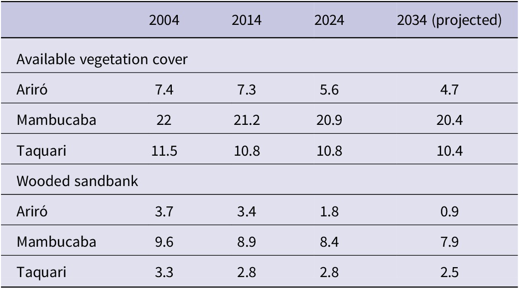
The EOO and AOO were also lower than those estimated in the IUCN assessment. We also did not record the species in Mangaratiba, São Gonçalo, or Barra Grande, which were considered in the national evaluation. We estimate a loss of 0.9% of vegetation cover in the last decade (2014–2024) in Mambucaba, and 23.2% in Ariró. Considering only the wooded sandbank vegetation, the loss was 5.6% in Mambucaba and 47% in Ariró. If the rate of forest cover loss remains constant in the coming years, we estimate an additional 50% reduction in the wooded sandbank vegetation for Ariró (Table 2).
Changes in vegetation cover (km2) over past two decades (2004–2024) and the projection for the next ten years
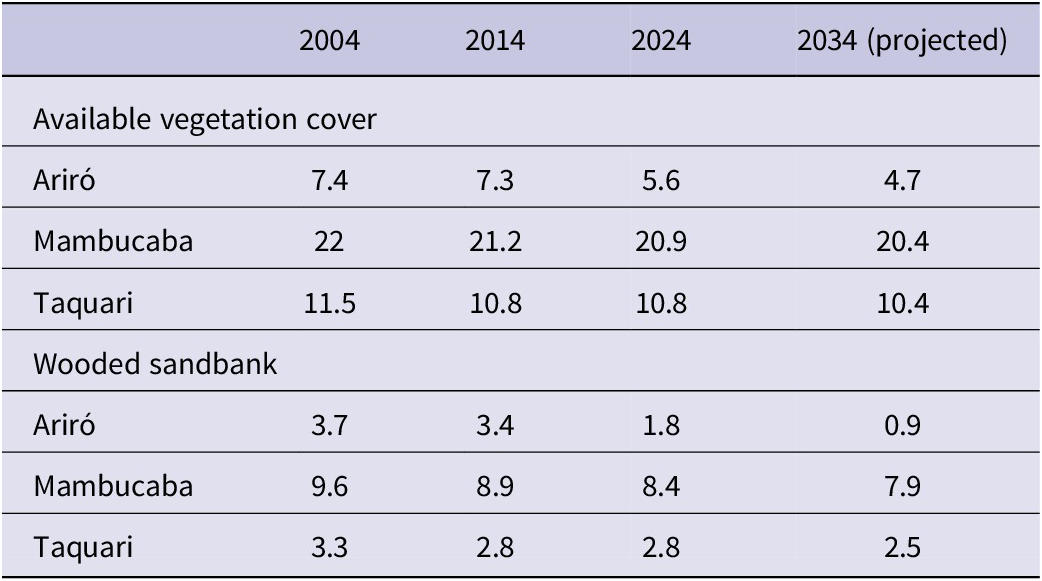
Table 2. Long description
The table is divided into two main sections: Total vegetation cover and Wooded sandbank cover. Data is provided for the years 2004, 2014, 2024, and a 2034 projection.
Total vegetation cover (km super 2):
* Ariró: 7.4 in 2004, 7.3 in 2014, 5.6 in 2024, and 4.7 projected for 2034.
* Mambucaba: 22 in 2004, 21.2 in 2014, 20.9 in 2024, and 20.4 projected for 2034.
* Taquari: 11.5 in 2004, 10.8 in 2014, 10.8 in 2024, and 10.4 projected for 2034.
Wooded sandbank cover (km super 2):
* Ariró: 3.7 in 2004, 3.4 in 2014, 1.8 in 2024, and 0.9 projected for 2034.
* Mambucaba: 9.6 in 2004, 8.9 in 2014, 8.4 in 2024, and 7.9 projected for 2034.
* Taquari: 3.3 in 2004, 2.8 in 2014, 2.8 in 2024, and 2.5 projected for 2034.
Discussion
Here, we provide the first objective and systematic approach to data on the conservation status of the Black-hooded Antwren. We aimed to sample as much of the potential range for the species and nearby areas as possible. However, it is important to emphasise that it is a vast area, characterised by frequent occurrences of larger estates and other private properties. Therefore, we focused on the geographic range of the species available in the IUCN and concentrated our searches where the species was most likely to occur (such as river valleys and lowlands), and where access was possible. Our goal was to assess whether the species exhibits a continuous distribution among the known populations. Sites we visited once or twice were either inaccessible during subsequent visits (usually private areas) or deemed unsuitable for the species’ occurrence (e.g. mangroves, steep hillsides, areas with high levels of urbanisation, or areas lacking available vegetation).
The species occupies lowland forests, avoiding slopes and mature forests, and shows a preference for disturbed secondary forests and regenerating areas, such as abandoned banana plantations (Mendonça Reference Mendonça2001), or areas with a dense understory but limited canopy shading (ICMBio 2018; Mendonça Reference Mendonça2001) (Figure 1d, e and f). Such areas correspond precisely to wooded sandbank vegetation, corresponding to category 49 of the raster. When occurrence points were plotted onto HabitatRaster, 73.77% of the confirmed records fell within wooded sandbank vegetation. The remaining 30% of the records, located in forest (category 3) or urban matrix (category 15), are found at forest edges or in areas of urban encroachment. Therefore, for conservation projects, wooded sandbank vegetation should be prioritised in the action plans.
Despite pseudo-absences being a major issue in species mapping, we consider them a minor problem for the Black-hooded Antwren. The species has low dispersal capacity, as expected for Thamnophilidae (Condell et al. Reference Condell, Robinson, Moore and Rourke2022), and exhibits territorial behaviour. Of the 11 individuals banded and later recaptured during the project, all were found at an average distance of 54 m (mean = 54.3 ± 54.94) from their original banding location, often with the same individual defending the same territory throughout the three-year study. Moreover, as they keep small permanent territories, it is expected to find several pairs occupying the same forest fragment as recorded for the congeneric Restinga Antwren F. serrana litorallis (Chaves et al. Reference Chaves, Vecchi, Kenup and Alves2019). These characteristics make the species very easy to detect; therefore, the absence of the species at all points located along a transect is a strong indication of a real absence. This is reinforced by the hierarchical multiscale occupancy model, which separates occupancy at the locality level from detection at the point level, so if a species remains undetected across all sampling points, the probability of true occupancy in that locality is low.
The habitat preference of the Black-hooded Antwren explains why it does not occur continuously throughout its entire extent of occurrence. A distinctive feature of the Costa Verde region is the abrupt meeting of the coastal mountain range with the Atlantic Ocean, characterised by steep slopes. As a result, the only available lowland areas are beaches, river valleys, and the valleys of Taquari, Mambucaba, Frade, Bracuí, and Ariró. The coastal strip is almost entirely occupied by farms, inns, private properties and mangroves; the river valleys are urbanised or have a very steep slope that seems avoided by the species, and Frade and Bracuí are highly urbanised. Thus, we believe there are possibly three, but at least two geographically isolated populations, one in Mambucaba and Taquari, and another in Ariró. However, we cannot confirm the existence of an established population in Taquari, as our assumption is based on only three pairs that appear to be floating.
In the absence of prior data on the species’ density, it is difficult to draw definitive conclusions about the population decline. However, certain indirect factors suggest a likely decrease in density in recent years: although comparison with other species is not an ideal approach, since they are inserted in different evolutionary and ecological contexts, one indication we have comes from a comparison with the Restinga Antwren, which showed a density of 90 individuals km-2 at the study sites (Mattos et al. Reference Mattos, Vale, Vecchi and Alves2009), contrasting with the 20 individuals km-2 for the Black-hooded Antwren in Mambucaba. Another indication comes from a master´s thesis on the Black-hooded Antwren (Mendonça Reference Mendonça2001), which mentions 156 pairs km-2 in Mambucaba and 89 pairs km-2 in Ariró, a much higher density than what we found. Since there was no reference to the methods used, the difference could be attributed to methodological variation, making a valid comparison impossible.
Our estimates of ≤212, with an upper bound of 365 individuals are valid under the assumption that the density in Mambucaba is uniformly similar to that of the sampled areas, and only if Taquari and Ariró exhibit the same level of abundance. However, we must note that neither of these conditions can be confirmed, as the sampled fragments in Mambucaba are much more densely occupied by the Black-hooded Antwren than other fragments in the valley, so the real density within the valley should be less than the 212 estimated individuals.
The greatest threat to the Black-hooded Antwren is habitat loss, and this pressure is intensified because the species occurs beyond the boundaries of protected areas. Mambucaba has undergone intense urbanisation over the past few decades, during which the village’s population has grown from 880 residents in 1970, to 17,700 in 2010 (Menegassi Reference Menegassi2021). A notable case is Ariró, which was considered a high-density region for the species around 25 years ago by Mendonça (Reference Mendonça2001). However, this was not observed during our study, as we recorded only six breeding pairs in this area. Since we do not have information on the coordinates of the study sites used by Mendonça (Reference Mendonça2001), it is difficult to make comparisons. An alarming factor is the loss of vegetation cover within this area’s valley: compared to 2004, Ariró lost 24.3% of its forest cover, equivalent to 180 hectares, while Taquari and Mambucaba lost 6.1% and 4.5%, respectively (Table 2). Furthermore, much of this deforestation occurred primarily within the land use category preferred by the species, the wooded sandbank vegetation: 50.3% in Ariro, 12.5% in Mambucaba, and 15% in Taquari (Table 2). What is even more concerning is that a large portion of this habitat loss occurred over a very short period, between 2017 and 2023 (Figure 5). Any large-scale human development could potentially cause the entire population of an area, such as Ariró, to disappear, if it has not already done so.
The deforestation in Ariró, in the Costa Verde region, Rio de Janeiro state, Brazil. From 2004 to 2023, Ariró lost 28,75% of its forest cover, equivalent to 230 hectares. Between 2017 and 2023, almost all secondary forest disappeared.
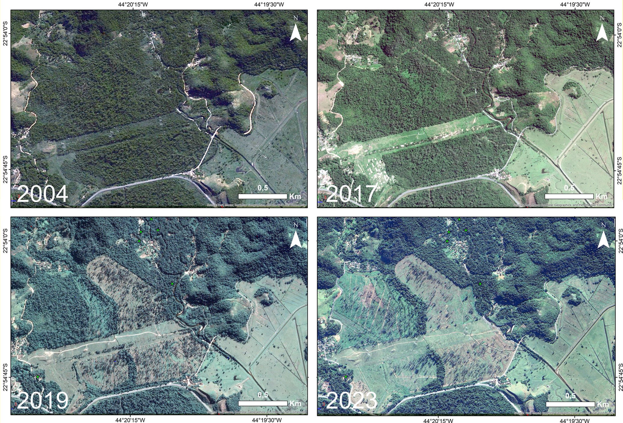
Figure 5. Long description
The multi-panel satellite maps are arranged in a two-by-two grid. Each panel includes a North arrow in the top-right, a 0.5 K m scale bar in the bottom-right, and geographic coordinates on the axes.
Top-left panel, 2004: The area is predominantly covered in dense, dark green forest. A thin, winding road enters from the West and runs through the center. Small patches of light green cleared land are visible in the Southeast and Northwest corners.
Top-right panel, 2017: The forest remains largely intact, but the light green cleared areas in the Southeast have expanded slightly. Small white clusters indicating structures or bare soil appear along the central road.
Bottom-left panel, 2019: Significant deforestation is visible. Large, irregular light green and tan patches have replaced the dark green forest in the central and West-central regions. These cleared areas show linear patterns, suggesting agricultural or development tracks.
Bottom-right panel, 2023: The deforestation has intensified. The light green cleared zones in the center and West have merged and expanded further North and South. Only fragmented patches of dark green secondary forest remain, primarily in the Northeast and extreme South.
Besides habitat loss, the species faces additional threats that may exert greater pressure due to its small population size. Domestic animals, such as dogs and cats, as well as invasive species like marmosets of the genus Callithrix, are common within the species’ range and represent potential predators. Furthermore, the Black-hooded Antwren builds its nests close to the ground and at vegetation edges (Mendonça Reference Mendonça2001), exposing them to risks. In the study area, vegetation edges are frequently cleared for road maintenance. During our study, one nest was abandoned after horses grazed on the vegetation supporting it. We also found an abandoned egg with a perforation in the shell caused by an unidentified predator (Figure 1c).
Our estimates are based on the populations we have recorded so that any new occurrence may update the information gathered here. Although the possible occurrence of the species far from its EOO, as reported for Cunhambebe State Park-Rio de Janeiro is notable, it appears to correspond more to a transient pair than to a small, locally-established population, since we did not detect the species in that valley during our surveys. The park managers recorded it for only a few months in 2023. If the record refers to a transient pair, how they reached the site remains unknown. Alternatively, if a small population is present, the area might have harboured an original population before the construction of the reservoir in the 1950s.
It is essential to implement measures to preserve the species’ habitat. The primary threat arises from the intense human occupation of lowland forests, as indicated by the high density of private properties and large estates. Because of that, the expansion of government protected areas is not feasible, so the establishment of private reserves represents a potentially more economically and socially viable conservation strategy. Given the ongoing habitat decline and the limited feasibility of expanding conservation areas, ex-situ conservation should be considered.
This was the first study employing an objective method and field-based data collection for the Black-hooded Antwren, and it presents replicable methods. We focused on existing information gaps to elucidate which valleys the species actually inhabits and estimated its population size, using a standardised methodological framework to enable future comparisons. The next step would be to maintain long-term monitoring to continuously assess species occurrence and replicate density estimates over time to detect potential population declines. This study provides an initial framework with systematised, replicable methods that will guide the formulation of conservation plans based on quantified evidence.
Supplementary material
The supplementary material for this article can be found at http://doi.org/10.1017/S0959270926100641.
Acknowledgments
This research was supported by the Brazilian Conselho Nacional de Desenvolvimento Científico e Tecnológico (CNPq; PQ #308.615/2022-0) and the Fundação Carlos Chagas Filho de Amparo à Pesquisa do Estado do Rio de Janeiro (FAPERJ; CNE #201126/2022) to Maria Alice S. Alves. Rio de Janeiro State University also supported Maria Alice S. Alves with productivity grants (UERJ/FAPERJ - Prociência). This study was financed in part by the Coordenação de Aperfeiçoamento de Pessoal de Nível Superior - Brasil (CAPES) - Finance Code 001 (scholarship to Andreza de Freitas N. Oliveira and Italo de Aleixo Faria) and by Idea Wild, which provided equipment support. We used AI (Grammarly) for textual revision and English language correction. We also thank Carlos Dutra, who kindly welcomed us and showed us the study area; our good friend Carlos Eduardo Blanco, who provided invaluable assistance during the fieldwork and with logistics and the Estação Ecológica de Tamoios for all the support we received during the fieldwork.
Competing interests
The author(s) declare none.