1. Introduction
In the Carboniferous Period, the Viséan–Serpukhovian transition was proposed to coincide with the onset of the main cooling phase during the Late Palaeozoic Ice Age (LPIA) (Fielding et al. Reference Fielding, Frank, Birgenheier, Rygel, Jones and Roberts2008; Montañez & Poulsen, Reference Montañez and Poulsen2013). This climate event, together with high-frequency glacioeustatic fluctuations, the Variscan Orogeny and closure of the equatorial Rheic seaway, resulted in pervasive discontinuous stratigraphical records and marine biotic provincialism worldwide (e.g. Nikolaeva & Kullmann, Reference Nikolaeva and Kullmann2001; Korn et al. Reference Korn, Titus, Ebbighausen, Mapes and Sudar2012; Wang et al. Reference Wang, Qie, Sheng, Qi, Wang, Liao, Shen and Ueno2013; Davydov & Cózar, Reference Davydov and Cózar2019). Due to a basin-wide unconformity coincident with the base of the Serpukhovian, the International Subcommission on Carboniferous Stratigraphy decided to search for a reliable faunal index to establish a Global Stratotype Section and Point (GSSP) close to the existing Viséan–Serpukhovian boundary (Richards & Task Group, Reference Richards2003, Reference Richards2005). Regional chronostratigraphy around this interval, mainly constructed with conodonts, foraminifers and ammonoids, was highly improved (e.g. Nikolaeva, Reference Nikolaeva2013; Richards, Reference Richards2013; Cózar & Somerville, Reference Cózar and Somerville2014, Reference Cózar and Somerville2016; Wang et al. Reference Wang, Korn, Nemyrovska and Qi2018; Cózar et al. Reference Cózar, Vachard, Aretz and Somerville2019; Nikolaeva et al. Reference Nikolaeva, Alekseev, Kulagina, Gatovsky, Ponomareva and Gibshman2020), and the first appearance datum (FAD) of the conodont Lochriea ziegleri Nemirovskaya, Perret-Mirouse and Meischner in the lineage L. nodosa (Bischoff)–L. ziegleri is often considered to be the best marker for the new boundary definition (Richards & Task Group, Reference Richards2005, Reference Richards2014). This proposal is located at a slightly lower level than the traditional boundary in the Moscow Basin (Gibshman et al. Reference Gibshman, Kabanov, Alekseev, Goreva, Moshkina, Alekseev and Goreva2009; Kabanov et al. Reference Kabanov, Alekseev, Gibshman, Gabdullin and Bershov2016), but it still awaits official ratification, probably because the taxonomy of L. ziegleri and the isochronism of its first occurrence datum (FOD) in different basins need to be evaluated further (Sevastopulo & Barham, Reference Sevastopulo and Barham2014; Barham et al. Reference Barham, Murray, Sevastopulo and Williams2015; Herbig, Reference Herbig2017; Cózar et al. Reference Cózar, Vachard, Aretz and Somerville2019).
The Naqing succession in South China contains the conodont lineage L. nodosa–L. ziegleri (Qi et al. Reference Qi, Nemyrovska, Wang, Chen, Wang, Lane, Richards, Hu and Wang2014 b) and was considered to be a suitable candidate for the Serpukhovian GSSP (Richards & Task Group, Reference Richards2014). Unfortunately, this section yields no ammonoid and scarce representative foraminifers (Groves et al. Reference Groves, Wang, Qi, Richards, Ueno and Wang2012), making it difficult to calibrate the FOD of the L. ziegleri precisely (Cózar et al. Reference Cózar, Vachard, Aretz and Somerville2019). Other carbonate-slope sections nearby, such as the Narao, Luokun and Dianzishang sections (Qi et al. Reference Qi, Hu, Wang and Lin2014 a; Wang et al. Reference Wang, Qi, Hu, Sheng and Lin2014; Sheng et al. Reference Sheng, Wang, Qi and Liao2021), provide little knowledge for the biostratigraphic calibration of the taxon as well.
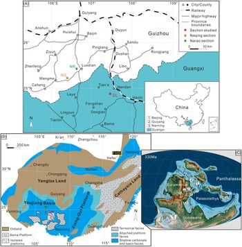
Here, we present foraminiferal and conodont records of the Baping Formation in the Danlu section, Youjiang Basin, South China (Fig. 1). The aims are (1) to calibrate the FOD of L. ziegleri in South China and (2) to assess the levels of diachronism of the FOD of L. ziegleri in different basins at a global scale.
Location map of the study area for the late Mississippian. (A) Index map showing the locations of the Danlu (DL), Naqing (NQ) and Narao (NR) sections. (B) Palaeogeographic map of South China (after Liu & Xu, Reference Liu and Xu1994) and location of the Youjiang Basin and Bama Platform. Yellow star represents the Fenghuangshan section (FHS). (C) Global palaeogeographic reconstruction (modified from Scotese, Reference Scotese2021). Yellow dots point to approximate locations of the Danlu section and the referred sections beyond South China. 1, Urals; 2, northern England; 3, Cantabrian Mountains; 4, Moscow Basin; 5, Donets; 6, Ireland; 7, Germany; 8, NW Serbia; 9, Danlu. Other abbreviations: N./S. China, North/South China.

2. Geological setting
During the late Mississippian, South China was situated within the eastern equatorial Palaeotethys (Fig. 1C). It mainly consists of the merged Yangtze and Cathaysia lands in the east, north and west, the attached platforms along the old land and the Xiang-Gui Platform and Youjiang Basin (also known as the Dian-Qian-Gui Basin or Nanpanjiang Basin) in the south (Fig. 1B) (Liu & Xu, Reference Liu and Xu1994; Liu et al. Reference Liu, Jarochowska, Du, Vachard and Munnecke2015).
Cherts and volcanic rocks recorded in the succession suggest that the Youjiang Basin was a rift basin during the Devonian, associated with the eastward expansion of the Palaeotethys (Du et al. Reference Du, Huang, Yang, Huang, Tao, Huang, Hu and Xie2013). Persistent rifting and subsidence during that time resulted in the development of two directional groups of faults (NW–SE and NE–SW), which regulated the palaeogeographic e-volution of the basin. Meanwhile, a number of tectonic blocks were detached from the southern margin of the Yangtze Land, giving rise to a submarine landscape composed of numerous isolated shallow-water carbonate platforms surrounded by basinal facies (Fig. 1B).
The Youjiang Basin evolved into a passive continental margin basin in the Mississippian, being tectonically quiescent for the Pennsylvanian (Du et al. Reference Du, Huang, Yang, Huang, Tao, Huang, Hu and Xie2013). Most of the isolated platforms were gradually drowned during the late Permian to Early Triassic, due to a tectonic transition of the Youjiang Basin to a foreland setting (Liu et al. Reference Liu, Jarochowska, Du, Vachard and Munnecke2015).
Four lithofacies groups and depositional settings were mainly distinguished for the Mississippian in the Youjiang Basin by Qi et al. (Reference Qi, Nemyrovska, Wang, Chen, Wang, Lane, Richards, Hu and Wang2014 b): (1) platform margin to slope facies with slumps and conglomerates; (2) platform margin with high-energy grainstones and reefs; (3) platform interior with low-energy shallow-marine carbonates and (4) shallow basins characterized by gravity flows.
The Bama Platform was one of such isolated platforms in the Youjiang Basin (Liu et al. Reference Liu, Jarochowska, Du, Vachard and Munnecke2015, Reference Liu, Vachard, Cózar and Coronado2023), and sections in the platform contain typical low-energy inner-platform carbonates (e.g. Gongchan and Shuidong) and platform marginal high-energy grainstones (e.g. Kacai). In contrast, the Danlu section (24°49′44″ N, 107°28′24″ E) studied herein for the first time is located in Wuai Town, Nandan County (Fig. 1A) and preserves the late Mississippian carbonate-slope deposits of the Bama Platform (along the northern margin). From bottom to top, it comprises the Baping Formation and the lowermost Nandan Formation (Fig. 2). Lithologically, these rocks are comparable to the coeval deposits from the Naqing section (Qi et al. Reference Qi, Nemyrovska, Wang, Chen, Wang, Lane, Richards, Hu and Wang2014 b).
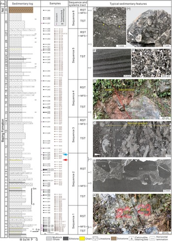
Detailed sedimentary log, sampling, sedimentology-based sequence and systems tract interpretation of the Danlu section. Red arrow corresponds to the Viséan–Serpukhovian boundary defined by foraminifers and blue arrow to the FOD of Lochriea ziegleri. For the right column: (A) a representative of transgressive–regressive systems tract (TST–RST) transition, with maximum flooding surface (MFS) being the boundary; (B–C) coarse irregular or abraded litho-/bioclasts in normal-graded pack- to grainstones; (D) the Viséan–Serpukhovian boundary interval; (E) laminated siltstones; (F) fine bioclastic grainstones in a TST; (G) a peloidal packstone layer in thin-bedded lime mudstones with common radiolarians (Ra) and sponge spicules (Ss), and the contact is sharp and irregular (yellow arrows); (H) normal-graded dolostones with abundant cm-scale lithoclasts (Lic). Other abbreviations: Fm, Formation; Nd, Nandan Formation; M, lime mudstone or shale; Ss/W, siltstone/wackestone; P, packstone; G, grainstone; Bi, bivalve; Cr, crinoid; For, foraminifer; Bry, bryozoan; P, peloid.

3. Sedimentology of the Danlu section
The Baping Formation (ca. 70 m thick) in the Danlu section, which underlies massive dolostones of the Nandan Formation (Pennsylvanian), is characterized by thin-bedded lime mudstones to wackestones intercalated with bioclast/intraclast-bearing packstones to grainstones (Fig. 2). Six lithofacies were separated, including lime mudstones to wackestones, laminated siltstones, bioclastic packstones and grainstones, normal-graded packstones to grainstones and massive dolostones.
Lime mudstones to wackestones are predominately thinly bedded and homogeneous, and in some cases weakly laminated or bioturbated. Radiolarian and sponge spicules are the most common components (Fig. 2G). Occasionally, this lithofacies is intercalated with laminated siltstones (Fig. 2E), or thin chert, shale, and peloidal packstone layers (Fig. 2G). Bioclastic packstones and grainstones mostly occur in the form of massive beds (up to 30 cm thick) and the contact with underlying mudstones to wackestones is irregular and sharp. Common carbonate grains incorporate foraminifers, crinoids, brachiopods and peloids (Fig. 2F). Although sharing some similarities with those bioclast-bearing limestones, normal-graded packstones to grainstones are distinguished by their normal-graded structure, thicker beds (ca. 40–120 cm), coarser grains and abundant poorly sorted irregular or abraded lithoclasts at the base (Fig. 2B, C). Massive dolostones capping the Baping Formation also exhibit the same features (Fig. 2H). These calcirudite-bearing beds occur in several intervals.
Common radiolarian and sponge spicules as well as rare bioturbation indicate that thin-bedded lime mudstones to wackestones were deposited in relatively deep-water conditions, below the storm wave base. Periodically concentrated normal-graded calcirudite-bearing beds, typically characterizing the base of turbidite sequences, are interpreted to be the result from turbidity currents on a slope environment during relative sea-level falls (Reijmer et al. Reference Reijmer, Palmieri and Groen2012; Chen et al. Reference Chen, Montañez, Qi, Wang, Wang and Lin2016). Bioclast-bearing beds intercalated within muddy limestones were probably formed by distal turbidity currents during relative sea-level rises. Increased pressure on platform margin and upper slope sediment stack during transgression has been suggested to bring about debris flows with fine bioclasts into deeper settings (cf. Lantzsch et al. Reference Lantzsch, Roth, Reijmer and Kinkel2007). On this basis, six transgression–regression sequences can be recognized (Fig. 2). Thinning-upward cycles are usually documented in transgressive systems tracts (Fig. 2A). Location of the maximum flooding surfaces between transgressive and regressive systems tracts is difficult, and tentatively, they have been situated at the base of the calcirudite-bearing beds.
The Viséan–Serpukhovian boundary in the Danlu section coincides with a lithological change from a chert to a calcirudite-bearing bed between units 10 and 11 (Fig. 2D). The first L. ziegleri is yielded within a lime mudstone bed from the top of unit 11. The boundary and the FOD of L. ziegleri are both located at the uppermost regressive systems tract of Sequence 2 (Fig. 2).
4. Conodont distribution and biostratigraphy
Overall, the conodont fauna in the Danlu section is dominated by three genera, that is, Gnathodus, Lochriea and Pseudognathodus (Figs. 3, 4; Supplemental Appendix 2).
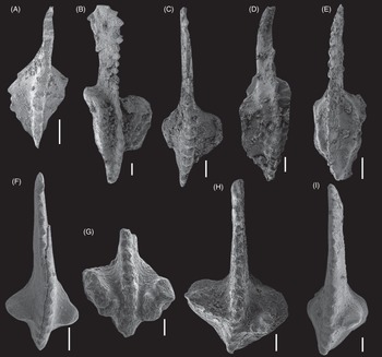
Significant conodont species from the Danlu section (oral view; scale bar = 100 μm). (A) Lochriea commutata, DL181, 0.46 m. (B–E) DL190, 2.06 m: (B) Gnathodus bilineatus bilineatus; (C) Lochriea saharae; (D) Gnathodus girtyi girtyi; (E) Pseudognathodus homopunctatus. (F) Lochriea costata, DL214, 20.36 m. (G–H) Lochriea ziegleri. (G) DL224, 25.22 m; (H) DL226, 27.36 m. (I) Lochriea nodosa, DL257, 66.87 m.

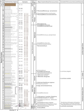
Chronostratigraphy of the Danlu section with records of major foraminiferal and conodont first occurrences. Abbreviation: Nd, Nandan Formation.

The base of the Danlu section mainly yields Gnathodus bilineatus bilineatus (Roundy) (Fig. 3B), G. girtyi girtyi Hass (Fig. 3D), G. cantabricus Belka & Lehmann, G. homopunctatus (Groessens & Noël), G. semiglaber Bischoff, Pseudognathodus homopunctatus (Ziegler) (Fig. 3E), Lochriea commutata (Branson & Mehl) (Fig. 3A) and L. saharae Nemyrovska, Perret-Mirouse and Weyant (Fig. 3C). This assemblage characterizes the Gnathodus bilineatus Zone from the basal Naqing section (Qi et al. Reference Qi, Nemyrovska, Wang, Chen, Wang, Lane, Richards, Hu and Wang2014 b; Hu et al. Reference Hu, Qi, Qie and Wang2020). The index taxon for the Lochriea nodosa Zone was not found at Danlu, within this zone, but is first recorded much higher in the section. Nevertheless, as proposed by Qi et al. (Reference Qi, Nemyrovska, Wang, Hu, Wang and Lane2018), L. costata Pazukhin & Nemirovskaya first occurs only slightly later than L. nodosa in South China, though these two taxa, both derived from L. commutata, underwent distinct evolutionary lineages. The occurrence of L. costata at DL214 (Fig. 3F), in association with some species from underlying zones, can be thus regarded as an indicator for the Lochriea nodosa Zone (Fig. 4). The lower boundary of the Lochriea ziegleri Zone in the Danlu section is marked by the first L. ziegleri at DL224 (Figs. 3G, 4). Higher up in the section, apart from some long-ranging taxa (e.g. L. nodosa Nemirovskaya, Perret-Mirouse and Meischner; Fig. 3I), no new age-diagnostic element occurs (Fig. 4; Supplemental Appendix 2).
5. Foraminiferal distribution and biostratigraphy
Foraminifers are nearly absent in the basal part of the Danlu section (units 0 and 1; Fig. 4) because of the dominance of mudstones (Supplemental Appendix 1). The occurrence of Endostaffella suggests that it can be assigned to the middle Viséan (Cózar et al. Reference Cózar, Somerville and Hounslow2022 a) or the Tulian Russian Substage.
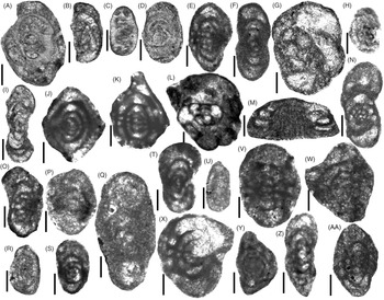
From unit 2, the assemblages change drastically, with more abundant and diverse foraminifers. It is noteworthy for the first occurrences of primitive Neoarchaediscus (e.g. N. aff. parvus (Rauser-Chernoussova); Fig. 5C, D), Palaeotextularia and Archaediscus spp. (at angulatus stage; Fig. 5B). Other important taxa in these levels are Cribrospira mira Rauser-Chernoussova, Cribrostomum, Omphalotis cf. omphalota (Rauser-Chernoussova & Reitlinger) and Archaediscus ex gr. karreri Brady (Fig. 5A). Higher up in unit 3, common Pseudoendothyra, Endostaffella (i.e. E. parva (Möller) and E. shamordini (Rauser-Chernoussova)), Eostaffella proikensis Rauser-Chernoussova (Fig. 5E) and the first representative of the genus ‘Millerella’ occur (Fig. 5F). The assemblages are assigned to the lowermost upper Viséan or Aleksinian Substage (e.g. Liu et al. Reference Liu, Vachard, Cózar and Coronado2023) (Fig. 4).
Significant foraminiferal species from the Danlu section (scale bar = 100 μm). (A–C) BDL12, 1.71 m: (A) Archaediscus ex gr. karreri; (B) Archaediscus at angulatus stage; (C) Neoarchaediscus aff. parvus. (D) Neoarchaediscus sp. BDL13, 2.02 m. (E–F) BDL21, 4.89 m: (E) Eostaffella proikensis; (F) ‘Millerella’ pauperis. (G) Bradyina potanini, DL211, 17.17 m. (H) Asteroarchaediscus rugosus, BDL41, 17.23 m. (I) ‘Millerella’ designata, DL219, 21.83 m. (J–K, O) BDL54, 25.37 m: (J) Eostaffella ikensis; (K) Eostaffella tenebrosa; (O) ‘Millerella’ tortula? (L–N) BDL51, 24.20 m: (L) Janischewskina delicata; (M) Howchinia subplana; (N) ‘Millerella’ tortula? (P–Q) BDL88, 44.47 m: (P) Eostaffellina decurta; (Q) Endothyranopsis plana. (R) Eosigmoilina sp. 1, BDL89, 44.97 m. (S–T) BDL100, 50.23 m, Eostaffellina ex gr. paraprotvae. (U–V) BDL115, 57.32 m: (U) Brenckleina sp.; (V) Eostaffellina paraprotvae. (W–X) Eostaffellina actuosa. (W) BDL 128, 63.00 m; (X) BDL115, 57.32 m. (Y) Pseudoglomospira multivoluta, BDL133, 65.00 m. (Z) Plectostaffella varvariensiformis, BDL132, 64.50 m. (AA) Plectostaffella ex gr. varvariensis, DL257, 66.87 m.

From unit 4 to 17 (Supplemental Appendices 1–2), foraminifers are still abundant, although in less amount than those in the older levels. At sample BDL24, Bradyina sp., Cribrospira cf. panderi Möller and Endothyranopsis cf. crassa (Brady) occur, whereas Eostaffella ikensis Vissarionova (Fig. 5J) is first recorded only 3 m above. In units 7–8, oblique sections of large Janischewskina occur, together with ‘Millerella’ designata Zeller (Fig. 5I), Bradyina potanini Venukoff (Fig. 5G) and Asteroarchaediscus rugosus (Rauser-Chernoussova) (Fig. 5H). This interval is assigned to the late Viséan Mikhailovian–Venevian substages (Fig. 4). Similar foraminiferal assemblages were also reported from coeval strata below the Viséan–Serpukhovian boundary elsewhere in South China, that is, in the Bradyina Zone of Shen & Wang (Reference Shen and Wang2015) and Shen et al. (Reference Shen, Wang, Li, Yang, Cen and Wang2020) and in the lower 48 m of the Yashui section (Groves et al. Reference Groves, Wang, Qi, Richards, Ueno and Wang2012).
Janischewskina delicata (Malakhova) (Fig. 5L), Howchinia subplana (Brazhnikova & Yartseva) (Fig. 5M) and specimens questionably assigned to ‘Millerella’ tortula? Zeller (Fig. 5N, O) first occur at sample BDL51 (Fig. 4). One and a half metres above, the first Eolasiodiscus is recorded. The FODs of J. delicata and ‘M.’ tortula have been used for the recognition of the base of the Serpukhovian in shallow-water facies (e.g. Gibshman, Reference Gibshman2003; Groves et al. Reference Groves, Wang, Qi, Richards, Ueno and Wang2012), whereas in deeper-water facies, representatives of the family Lasiodiscidae (as Howchinia subplana and Eolasiodiscus) are usually more robust markers (Nikolaeva et al. Reference Nikolaeva, Kulagina, Pazukhin, Kochetova and Konvalova2009, Reference Nikolaeva, Alekseev, Kulagina, Gatovsky, Ponomareva and Gibshman2020; Kulagina et al. Reference Kulagina, Stepanova, Kucheva and Nikolaeva2011; Cózar et al. Reference Cózar, Somerville, Sanz-López and Blanco-Ferrera2016, Reference Cózar, Vachard, Aretz and Somerville2019; Vachard et al. Reference Vachard, Cózar, Aretz and Izart2016). This group of four taxa allows recognition of the base of the Serpukhovian from sample BDL51, at the base of unit 11.
From unit 18, foraminiferal diversity and abundance decrease notably. At sample BDL88, Eostaffellina decurta (Rauser-Chernoussova) (Fig. 5P) and Endothyranopsis plana Brazhnikova (Fig. 5Q) first occur, and 0.5 m above, Eosigmoilina sp. 1 (Fig. 5R) occurs (Fig. 4). Eostaffellina decurta is a classical marker for the Steshevian in the Russian Platform (Lipina & Reitlinger, Reference Lipina and Reitlinger1971), although its first occurrence in the Tarusian is still debated (Reitlinger et al. Reference Reitlinger, Vdovenko, Gubareva, Shcherbakov, Wagner, Winkler Prins and Granados1996). In South China, it has been recorded in the latest Serpukhovian (Sheng et al. Reference Sheng, Wang, Brenckle and Huber2018) or close to the base of the Serpukhovian (Sheng et al. Reference Sheng, Wang, Qi and Liao2021). This taxon, however, seems to be a valid Steshevian marker in varied depositional settings from Western Europe (e.g. Cózar & Somerville, Reference Cózar and Somerville2016, Reference Cózar and Somerville2021 a; Cózar et al. Reference Cózar, Somerville, Sanz-López and Blanco-Ferrera2016; Vachard et al. Reference Vachard, Cózar, Aretz and Izart2016) and also in the Bama Platform, South China (Liu et al. Reference Liu, Vachard, Cózar and Coronado2023). In addition, Endothyranopsis plana is also documented in levels with E. decurta and close to Brenckleina (Cózar et al. Reference Cózar, Somerville, Sanz-López and Blanco-Ferrera2016; Cózar & Somerville, Reference Cózar and Somerville2021 a). Hence, there are sufficient arguments to consider this part of the Danlu section as equivalent to the Steshevian (Fig. 4).
Slightly higher up in the succession, at BDL100, the first Eostaffellina ex gr. paraprotvae (Rauser-Chernoussova) (Fig. 5S, T) occurs. These narrow forms are known from the Steshevian (Gibshman et al. Reference Gibshman, Kabanov, Alekseev, Goreva, Moshkina, Alekseev and Goreva2009; Cózar & Somerville, Reference Cózar and Somerville2016, Reference Cózar and Somerville2021 a, b; Vachard et al. Reference Vachard, Cózar, Aretz and Izart2016; Liu et al. Reference Liu, Vachard, Cózar and Coronado2023), nearly at the same level with Eostaffellina decurta. Hence, this part of the section is also assigned to the Steshevian (Fig. 4).
Sample BDL115 contains the first occurrences of Brenckleina sp. (Fig. 5U), Eostaffellina paraprotvae (Fig. 5V) and E. actuosa Reitlinger (Fig. 5W, X). Brenckleina is notably recorded from the late Serpukhovian, but rarely, it has been reported from the upper part of the Steshevian (Poletaev et al. Reference Poletaev, Brazhnikova, Vasilyuk and Vdovenko1991) or in intermediate positions of this substage from Tian Shan, England, Ireland and Spain (Kulagina et al. Reference Kulagina, Rumyantseva, Pazukhin and Kochetova1992; Cózar & Somerville, 2014; Reference Cózar and Somerville2016, Reference Cózar and Somerville2021 b; Cózar et al. Reference Cózar, Somerville, Sanz-López and Blanco-Ferrera2016). In contrast, E. actuosa is a marker for the late Serpukhovian, and this interval can be correlated with the Protvian E. actuosa Zone of Kulagina et al. (Reference Kulagina, Nikolaeva, Pazukhin and Kochetova2014).
In the uppermost part of the Danlu section, below the massive dolostones, Plectostaffella varvariensiformis Brazhnikova & Vdovenko (Fig. 5Z), P. ex gr. varvariensis (Brazhnikova & Potievskaya) (Fig. 5AA) and common Pseudoglomospira multivoluta Hance, Hou and Vachard (Fig. 5Y) are first recorded (Fig. 4). This interval can be correlated with the Zapaltyubian Substage in China (Liu et al. Reference Liu, Vachard, Cózar and Coronado2023).
6. Evaluating the diachronism in the FODs of Lochriea ziegleri
6.a. Constraints from sequence stratigraphy
High-amplitude sea-level falls related to the onset of the main phases of glaciation during the LPIA have been suggested to control the depositional architectures of tectonically stable craton basins worldwide (e.g. Smith & Read, Reference Smith and Read2000; Wright & Vanstone, Reference Wright and Vanstone2001; Bishop et al. Reference Bishop, Montañez, Gulbranson and Brenckle2009; Eros et al. Reference Eros, Montañez, Osleger, Davydov, Nemyrovska, Poletaev and Zhykalyak2012; Fielding & Frank, Reference Fielding and Frank2015; Chen et al. Reference Chen, Sheng, Hu, Yao, Lin, Montañez, Tian, Qi and Wang2019; Cózar et al. Reference Cózar, Somerville, Hounslow and Coronado2022 b; Montañez, Reference Montañez2022). Hence, sequence stratigraphy in those regions should be similar, unless regional tectonics have overridden glacioeustasy and modified the patterns. Major substage boundaries have been frequently correlated (e.g. Eros et al. Reference Eros, Montañez, Osleger, Davydov, Nemyrovska, Poletaev and Zhykalyak2012), although as Cózar & Somerville (Reference Cózar and Somerville2014) and Cózar et al. (Reference Cózar, Somerville, Blanco-Ferrera and Sanz-López2018) highlighted, these glacioeustatic or onlap–offlap correlations fail when there are no solid biostratigraphic calibrations.
In the Naqing section of South China, Chen et al. (Reference Chen, Montañez, Qi, Wang, Wang and Lin2016) attributed the Viséan–Serpukhovian transition to a lowstand systems tract, which was suggested to correlate with a palaeokarst with development of thick paleosols in the platform-top Yashui section. In the Danlu section, the FOD of L. ziegleri is at the uppermost part of a regressive systems tract (Fig. 2). To reconcile this fact, the first occurrence of L. ziegleri in South China is interpreted to have been accompanied by a sea-level lowstand.
In the South Urals, only transgressive–regressive sequences were recognized in the Verkhnyaya Kardailovka section (Richards et al. Reference Richards, Nikolaeva, Kulagina, Alekseev, Gorozhanina, Gorozhanin, Konovalova, Goreva, Joachimski and Gatovsky2017). The FOD of L. ziegleri is located at an intermediate position of a regressive phase and the lowstand systems tract might develop in much younger strata (Richards et al. Reference Richards, Nikolaeva, Kulagina, Alekseev, Gorozhanina, Gorozhanin, Konovalova, Goreva, Joachimski and Gatovsky2017).
In northern England, marked cyclicity in the Yoredale Series is also composed of transgressive–regressive cycles. Generally, the basal limestones represent rapid transgressions, and the overlying limestones and detrital rocks (e.g. shales, siltstones, sandstones and coals) formed in slow regressive phases, with the capped coals constituting the lowstands of the platform. Considering the FOD of L. ziegleri is recorded in the lower Middle Limestone (Sevastopulo & Barham, Reference Sevastopulo and Barham2014), it possibly corresponds to a transgressive phase or a transgressive–regressive transition.
In the Cantabrian Mountains (NW Spain), detailed sequence stratigraphy has not been published yet, but in the Vegas de Sotres section, units 1–3 (Canalón Member, Alba Formation) can be interpreted as an overall regressive phase (Cózar et al. Reference Cózar, Somerville, Sanz-López and Blanco-Ferrera2016), and the overlying Millaró Member is a notable drowning of the basin (Sanz-López et al. Reference Sanz-López, Blanco-Ferrera and Sánchez de Posada2004, Reference Sanz-López, Blanco-Ferrera, Sánchez de Posada and García-López2007), corresponding to a rapid transgression. As a result, the FOD of L. ziegleri at the uppermost unit 1 is situated in a long-term regression sequence.
In the Moscow Basin, the FOD of L. ziegleri coincides with a transgressive–regressive transition in the Novogurovsky section (Gibshman et al. Reference Gibshman, Kabanov, Alekseev, Goreva, Moshkina, Alekseev and Goreva2009; Kabanov et al. Reference Kabanov, Alekseev, Gibshman, Gabdullin and Bershov2016), whereas in the French Pyrenees it occurs within a long-term transgression (Perret in Skompski et al. Reference Skompski, Alekseev, Meischner, Nemyrovska, Perret and Varker1995).
In summary, the FOD of L. ziegleri coincides with (i) a transgressive–regressive transition (e.g. in Northern England and Moscow Basin), (ii) a regressive phase (e.g. in the South Urals and Cantabrian Mountains), (iii) a transgression phase (e.g. in France) or (iv) a sea-level lowstand (e.g. in South China). These contrasting results do not support a synchronous first occurrence of L. ziegleri worldwide, although more detailed sedimentological and palaeontological studies would improve the apparent mismatches.
6.b. Constraints from the foraminifers and ammonoids
Along with searching for a more or less synchronous first occurrence of L. ziegleri, the number of studies on ammonoids and foraminifers from the Viséan–Serpukhovian boundary interval has also increased in the last decade, in order to determine the species with more consistent first occurrences (e.g. Kulagina et al. Reference Kulagina, Gorozhanina, Gorozhanin and Filimonova2019; Nikolaeva et al. Reference Nikolaeva, Alekseev, Kulagina, Gatovsky, Ponomareva and Gibshman2020; Aleeksev et al. Reference Alekseev, Nikolaeva, Goreva, Donova, Kossovaya, Kulagina, Kucheva, Kurilenko, Kutygin, Popeko, Stepanova, Lucas, Schneider, Wang and Nikolaeva2022). In the case of foraminifers, although facies-control problems and potential delays in the dispersion of some species around the Palaeotethys could be distinguished, a few of better markers for the Viséan–Serpukhovian boundary in outer and inner platform facies have been selected (Cózar et al. Reference Cózar, Vachard, Aretz and Somerville2019, fig. 8). These and other previous studies have improved notably the calibration between zonal schemes of different fossil groups, allowing to clarify which species of ammonoids and foraminifers are considered as first occurring at the uppermost Viséan, at the base of the Serpukhovian or even in younger levels of this latter stage.
The Danlu section is noteworthy for the low abundance in conodonts; however, as mentioned above, the FOD of L. ziegleri is at sample DL224, 1.68 m above the base of the Tarusian defined with foraminifers. The occurrence of some ammonoids and foraminifers compared to L. ziegleri is not consistent in other basins around the world. In total, four possible scenarios or groups are observed.
6.b.1. Sections with the FOD of L. ziegleri in the Steshevian or Protvian (group 1)
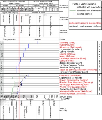
Sections representative of this first group (Fig. 6) are the Kugarchi and Mariinsky sections in the Urals, Donets (Ukraine), Craven Basin in England and Kilnamona and Lugasnaghta in Ireland (Cózar & Somerville, Reference Cózar and Somerville2021 a).
FODs of Lochriea ziegleri in different basins. In the upper part, Pennines (England) chronostratigraphy, foraminiferal zones (1–14; Cózar & Somerville, Reference Cózar and Somerville2021 a) and their correlations with the ammonoid zones in shallow-water platforms of England (B2 to E2c) are included. In the lower part, the Urals chronostratigraphy is compared with that of the basinal Craven Basin (England) and the regional ammonoid zones proposed by Nikolaeva (Reference Nikolaeva2013). Note the different correlation of the ammonoid zones from England below the E1c subzone using the calibration of foraminifers in the Pennines and the ammonoids from the Urals (grey areas in Craven and Pennines). Inferred position corresponds to the recognized ammonoid zones using the calibration in the Pennines.

Nikolaeva et al. (Reference Nikolaeva, Kulagina, Gorozhanina, Alekseev and Konovalova2017) interpreted the FOD of L. ziegleri in the Kugarchi section at levels equivalent to the Steshevian and attributed its absence from older levels to hostile settings. In the Mariinsky, the well-formed P1 elements of L. ziegleri from the base of the section make Nikolaeva et al. (Reference Nikolaeva, Alekseev, Kulagina, Gatovsky, Ponomareva and Gibshman2020) consider that its FOD should be in much lower levels. This inference explains the first occurrence of Monotaxinoides transitorius Brazhnikova and Yartseva, a classical marker for the Zapaltyubian in most Russian zonal schemes, only 10 m above the base, suggesting that the FOD of L. ziegleri might be located within the Protvian.
In Ukraine and Craven Basin in England, the first occurrence of L. ziegleri is also certainly late, that is, at levels close to the base of the Namurian (maybe equivalent to the uppermost Tarusian to lowermost Steshevian; Fig. 6) (Metcalfe, Reference Metcalfe1981; Skompski et al. Reference Skompski, Alekseev, Meischner, Nemyrovska, Perret and Varker1995; Sevastopulo & Barham, Reference Sevastopulo and Barham2014). However, some authors inferred its FOD within B8–B9 limestones or sequence Se-I of the Donets (Davydov et al. Reference Davydov, Crowley, Schmitz and Poletaev2010; Eros et al. Reference Eros, Montañez, Osleger, Davydov, Nemyrovska, Poletaev and Zhykalyak2012), although the oldest confirmed FOD of this taxon in Ukraine is in sequence Se-VII, which probably corresponds to the Steshevian Substage (Cózar et al. Reference Cózar, Vachard, Aretz and Somerville2019).
In Ireland, the biostratigraphy at Lugasnaghta is still debated, due to a contradiction between the ammonoid and foraminiferal records. There, Neoarchaediscus postrugosus (Reitlinger) and other Tarusian foraminiferal markers have been found far below the Ardvarney Limestone Member, where the P2a subzone was located (Sevastopulo & Barham, Reference Sevastopulo and Barham2014). According to the ammonoids, the FOD of L. ziegleri would correspond to the base of the Tarusian, whereas foraminifers suggest a Steshevian Substage (Cózar & Somerville, Reference Cózar and Somerville2021 b). At Kilnamona, by contrast, its FOD has been well constrained to levels of the E1a subzone, within the middle part of the Steshevian (Fig. 6)
In this group of sections, as suggested by Nikolaeva et al. (Reference Nikolaeva, Alekseev, Kulagina, Gatovsky, Ponomareva and Gibshman2020), it seems to concur two problems, that is, the presence of hostile facies and the poverty in conodonts in shallow-water facies. These problems led to a certain late occurrence of L. ziegleri. Higher sampling effort might improve the resolution of the fossils in those regions.
The Narao and Naqing sections from South China might be also incorporated in this group, but its biostratigraphy has not been sufficiently constrained yet. In the Naqing section, only scarce foraminiferal representatives are present (Groves et al. Reference Groves, Wang, Qi, Richards, Ueno and Wang2012). Although Sheng (Reference Sheng2017) and Wang et al. (Reference Wang, Qi, Korn, Chen, Sheng and Nemyrovska2017) mentioned that Janischewskina delicata and Bradyina aff. cribrostomata Rauser-Chernoussova & Reitlinger are recorded at 2.15 and 2.20 m above the FOD of L. ziegleri, respectively, none of the species were illustrated. As discussed in Cózar et al. (Reference Cózar, Vachard, Aretz and Somerville2019), the occurrence of B. aff. cribrostomata close to the base of the Serpukhovian is unusual. The oldest record of B. cribrostomata in the literature seems to be at the uppermost lower Serpukhovian (Aizenverg et al. Reference Aizenverg, Astakhova, Berchenko, Brazhnikova, Vdovenko, Dunaeva, Zernetskaya, Poletaev and Sergeeva1983; Cózar & Somerville, Reference Cózar and Somerville2021 a), whereas a more common occurrence is in the upper Serpukhovian (Conil et al. Reference Conil, Groessens, Laloux, Poty and Tourneur1991; Reitlinger et al. Reference Reitlinger, Vdovenko, Gubareva, Shcherbakov, Wagner, Winkler Prins and Granados1996; Cózar et al. Reference Cózar, Said, Somerville, Vachard, Medina-Varea, Rodríguez and Berkhli2011). In the Fenghuangshan section, this species was selected as the nominal taxon for the B. cribrostomata Zone, representative of the late Serpukhovian Protvian Substage (Sheng et al. Reference Sheng, Wang, Brenckle and Huber2018). Similarly, foraminiferal biostratigraphy from the Bama Platform, Youjiang Basin, suggests that B. cribrostomata is first recorded from levels equivalent to the uppermost Steshevian (Liu et al. Reference Liu, Vachard, Cózar and Coronado2023). On the other hand, the Narao section records the first J. delicata ca. 2.2 m above the FOD of L. ziegleri (Sheng et al. Reference Sheng, Wang, Qi and Liao2021). However, the specimen was obtained from a thick conglomerate, and thus, reworking can be assumed. The illustrated Eostaffellina decurta ca. 4.0 m above the FOD of L. ziegleri (Sheng et al. Reference Sheng, Wang, Qi and Liao2021) is one of typical narrow and small forms attributed here to Eostaffellina ex gr. paraprotvae (compared with Fig. 5S), which, similar to the Danlu section, in the shallow-water Bama Platform, first occurs in the Steshevian (Liu et al. Reference Liu, Vachard, Cózar and Coronado2023). In consequence, the close entry of L. ziegleri to B. aff. cribrostomata and Eostaffellina ex gr. paraprotvae suggests that the first L. ziegleri might occur later in these two sections, likely corresponding to slightly higher levels in the Tarusian, or even in the Steshevian (Fig. 6).
6.b.2. Sections with the FOD of L. ziegleri slightly above the base of the Serpukhovian (group 2)
Among the second group of sections, taking into consideration the problems with the ammonoid biostratigraphic correlations (e.g. Nikolaeva & Kullmann, Reference Nikolaeva and Kullmann2001; Nikolaeva Reference Nikolaeva2013), the FODs of L. ziegleri seem to be above the basal P2a subzone (Fig. 6), and thus, above the level equivalent to the base of the Tarusian in the Pennines. Such cases include the Rhenish Slate Mountains and Wenne River bank sections in Germany (Skompski et al. Reference Skompski, Alekseev, Meischner, Nemyrovska, Perret and Varker1995; Wang et al. Reference Wang, Korn, Nemyrovska and Qi2018), the Ladeinaya Mountains and Verkhnyaya Kardailovka in the Urals (Nikolaeva et al. Reference Nikolaeva, Kulagina, Pazukhin, Kochetova and Konvalova2009, Reference Nikolaeva, Alekseev, Kulagina, Gatovsky, Ponomareva and Gibshman2020; Richards et al. Reference Richards, Nikolaeva, Kulagina, Alekseev, Gorozhanina, Gorozhanin, Konovalova, Goreva, Joachimski and Gatovsky2017) and the Danlu section.
Nemyrovskaya et al. (Reference Nemirovskaya, Perret and Meischner1994) previously considered the FOD of L. ziegleri in the Rhenish Slate Mountains in the P1d subzone, but a revision by Herbig (Reference Herbig2017) and Herbig et al. (Reference Herbig, Bätz, Resag, Zholtaev, Zhaimina, Fazylov, Nikolaeva and Musina2017) indicated that it could not be confirmed an older FOD of L. ziegleri below the P2b subzone (= upper Tarusian; Fig. 6). Thus, the FOD of L. ziegleri in this region of Germany is still pending of confirmation (Sevastopulo & Barham, Reference Sevastopulo and Barham2014).
The slight delay of the FOD of L. ziegleri in the Ladeinaya Mountains and Danlu sections could be attributed to the poverty in conodonts, due to their relatively shallower-water settings than others, which explains the richest foraminiferal assemblages, as well as the common occurrence of foraminifers predominantly from shallow-water platforms. Alternatively, this delay might result from hostile facies (i.e. cherty and bituminous beds).
The delay observed in the Wenne River Bank and Verkhnyaya Kardailovka sections (Fig. 6) might be related to the mismatch in the correlation of the ammonoid zones recognized from the basinal facies (e.g. Craven Basin) and shallow-water platforms (e.g. Pennines), with these latter zones calibrated with foraminiferal zones defined in other regions (e.g. the Moscow Basin). Hence, this apparent late occurrence of L. ziegleri might be an artefact generated by incorrect ammonoid-foraminiferal zonal calibrations.
6.b.3. Sections with the FOD of L. ziegleri coinciding with the base of the Serpukhovian (group 3)
In some sections (the third group), the FOD of L. ziegleri coincides with the base of the P2a subzone or the base of the Tarusian, such as the Milivojevića Kamenjar section in Serbia (Sudar et al. Reference Sudar, Novak, Korn and Jovanović2018), Derbyshire in England (Higgins, Reference Higgins1975) and Zaborie in Russia (Kabanov et al. Reference Kabanov, Gibshman, Barskov, Alekseev, Goreva, Alekseev and Goreva2009).
In the Zaborie Quarry, it is difficult to obtain older records of L. ziegleri, because there are only two beds assigned to the Venevian, and currently, only bed 2 is exposed (Kabanov et al. Reference Kabanov, Gibshman, Barskov, Alekseev, Goreva, Alekseev and Goreva2009). Thus, the absence of older L. ziegleri might be an artefact due to the nearly absence of Venevian strata (mostly covered).
In Derbyshire, the FOD of L. ziegleri coincides with a major lithological change, from the Eyam Limestone (bioclastic shallow-water limestones and reefs) to the Widmerpool (deep-water mudstones and shales) formations. Thus, the occurrence of the conodont from the latter formation might be a matter of facies control. A similar scenario is also observed in the Milivojevića Kamenjar section, where nearly all the ornamented Lochriea first occur together in less than 1 m of strata, with a major lithological change from light-grey thick-bedded to massive micritic limestones passing into well-bedded nodular micritic limestones (Sudar et al. Reference Sudar, Novak, Korn and Jovanović2018).
6.b.4. Sections with the FOD of L. ziegleri in slightly older levels than the base of the Serpukhovian (group 4)
In a final fourth group of sections, the FODs of L. ziegleri coincide with the P1d subzone or intermediate levels in the Venevian, including the successions from the southern Pennines in northern England (Varker in Skompski et al. Reference Skompski, Alekseev, Meischner, Nemyrovska, Perret and Varker1995), the French Pyrenees (Perret in Skompski et al. Reference Skompski, Alekseev, Meischner, Nemyrovska, Perret and Varker1995), the Novogurovsky and Lan’shino sections in the Moscow Basin (Alekseev in Skompski et al. Reference Skompski, Alekseev, Meischner, Nemyrovska, Perret and Varker1995; Gibshman et al. Reference Gibshman, Kabanov, Alekseev, Goreva, Moshkina, Alekseev and Goreva2009) and the Vegas de Sotres section in NW Spain (Cózar et al. Reference Cózar, Somerville, Sanz-López and Blanco-Ferrera2016) (Fig. 6).
Only these sections agree with the inferred FAD of L. ziegleri in levels slightly older than the current base of the Serpukhovian, the requirement suggested by Richards & Task Group (Reference Richards2005) to be a reliable marker for the Viséan–Serpukhovian boundary. Nevertheless, for the groups 1–3, although there are some reasonable explanations to justify a possible delay in the FOD of L. ziegleri in some of the sections, in general, they suggest a lack of synchronicity (Fig. 6).
It can be inferred that further studies are necessary to clarify the above-described problems, including more intensive samplings for foraminifers, conodonts and ammonoids in those sections where some discrepancies have been observed.
7. Conclusions
Sequence stratigraphy, foraminifers and conodonts of the Baping Formation in the carbonate-slope Danlu section, Youjiang Basin, allow to constrain the stratigraphical context and the FOD of the conodont Lochriea ziegleri with potential foraminiferal markers near the Viséan–Serpukhovian boundary in China. The apparent delays in the FODs of L. ziegleri in some basins and the problems in its calibration caused by the use of different fossil groups, zonal schemes and indirect correlations demonstrate that the assumed synchronous FAD of the conodont cannot be confirmed. In addition to a lack of synchronicity, independently evidenced by distinct sequence stratigraphic contexts, some apparent later occurrences might be also in part due to poor calibrations between deep- and shallow-water zonal schemes, as well as the frequent presence of favourable or hostile facies for conodonts. Some of those problems have not been investigated sufficiently or are currently in progress. Therefore, it is recommended that more parameters should be investigated for the recognition of a new base for the Serpukhovian, as well as to achieve a far better correlation between different zonal schemes and fossil groups.
Supplementary material
To view supplementary material for this article, please visit https://doi.org/10.1017/S0016756823000262
Acknowledgements
We would like to thank I.D. Somerville and F. Le Coze for their constructive comments. Prof. Dr. W. Qie in Nanjing Institute of Geology and Palaeontology, Chinese Academy of Sciences is appreciated for his help in conodont identification and constructive comments on an early draft. This contribution was financially supported by the National Natural Science Foundation of China (C. Liu, grant Numbers 42172120, 41902102, U1812402, and 41872117), the Fundamental Research Funds for the Universities of Henan Province (C. Liu) and the Henan Province Key Research and Development and Promotion Special Project (F. Zhang, Grant number 22210224004).
Conflicts of interest
The authors declare that they have no known competing financial interests or personal relationships that could have appeared to influence the work reported in this paper.