INTRODUCTION
Coral records of bomb-produced radiocarbon (14C) from atmospheric testing of thermonuclear devices are now sparsely available across the tropical and subtropical Pacific Ocean, ranging from the most northerly in the world at Kure Atoll (Hawaiian Archipelago; Dana Reference Dana1971; Andrews et al. Reference Andrews, Siciliano, Potts, DeMartini and Covarrubias2016c) to Easter Island (Rapa Nui, Chile; Biddulf et al. 2006) in the south, with various records across the Indo-Pacific region from the Great Barrier Reef to Japan and the Indian Ocean (e.g., Grumet et al. Reference Grumet, Abram, Beck, Dunbar, Gagan, Guilderson, Hantoro and Suwargadi2004; Mitsuguchi et al. Reference Mitsuguchi, Hirota, Yamazaki, Watanabe and Yamano2016; Ramos et al. Reference Ramos, Goodkin, Druffel, Fan and Siringan2019, Wu et al. Reference Wu, Fallon, Cantin and Lough2021). In general, bomb-produced 14C in the 1950s entered the mixed layer of tropical and subtropical oceans through air-sea diffusion in the late 1950s (Grottoli and Eakin Reference Grottoli and Eakin2007). Observed differences among coral 14C records arise from surface-water mixing with older, upwelled 14C-depleted waters, coupled with variable air-sea diffusion rates due to wind forcing, ocean temperature, and differential air-sea CO2 saturation states. These effects are manifested across the Pacific Ocean as differences in the magnitude and timing of the bomb 14C peak and post-peak decline (Druffel Reference Druffel2002). Despite these differences, the 14C rise period (∼1958–1968) has proved useful as a time-specific marker in age validation studies of various marine organisms that form conserved skeletal and non-skeletal structures throughout the Pacific Ocean (Kalish Reference Kalish1993; Fallon et al. Reference Fallon, Guilderson and Caldeira2003; Darenougue et al. Reference Darrenougue, De Deckker, Payri, Eggins and Fallon2013; Andrews et al. Reference Andrews, Choat, Hamilton and DeMartini2015; Kubota et al. Reference Kubota, Shirai, Murakami-Sugihara, Seike, Minami, Nakamura and Tanabe2018).
Many of these Pacific coral 14C records provide evidence of post-peak 14C declines that point to a convergence among the various 14C records that may be useful in other age validation studies (Andrews et al. Reference Andrews, Asami, Iryu, Kobayashi and Camacho2016a, Reference Andrews, Siciliano, Potts, DeMartini and Covarrubias2016c; Ramos et al. Reference Ramos, Goodkin, Druffel, Fan and Siringan2019; Wu et al. Reference Wu, Fallon, Cantin and Lough2021). Specifically, bomb 14C dating of fishes typically requires that the specimen lived through the late 1950s to mid-1960s to use the diagnostic 14C rise period as a chronological reference, but some fishes may not have a long lifespan (on the order of 1–3 decades) or archived otoliths available that would provide birth years in the bomb 14C rise period; however, the post-peak 14C decline period provides a novel approach to determining the age of shorter-lived fishes from recent collections, such as the ulua or giant trevally (Caranx ignobilis) of the Hawaiian Islands that was validated with bomb 14C dating to live 25 yr using this approach (Andrews Reference Andrews2020). Other recent investigations that are similar provided the first valid estimates of age for blue marlin (Makaira nigricans) to ∼20 yr and Pacific bluefin tuna (Thunnus orientalis) to ∼30 yr with birth years during the post-peak decline period in the 1980s to 2000s (Ishihara et al. Reference Ishihara, Abe, Shimose, Takeuchi and Aires-Da-Sliva2017; Andrews et al. Reference Andrews, Humphreys and Sampaga2018). Hence, more comprehensive reference records that can extend the bomb-produced 14C chronology in both time and space for the tropical and subtropical Pacific Ocean should be pursued as a tool for these unique and important fisheries studies.
The focus of this study was to provide a robust coral chronology of bomb-produced 14C from American Samoa and describe its attributes in both oceanography and as a tool in age validation studies. Located along the northern edge of the South Pacific Gyre (SPG) and in the path of the westward flowing South Equatorial Current (SEC), this record provides a unique opportunity to compare and contrast the timing and magnitude of the bomb 14C signal across the SPG. Existing coral 14C chronologies from Easter Island (Biddulph et al. Reference Biddulph, Beck, Burr and Donahue2006) and Rarotonga (Guilderson et al. Reference Guilderson, Schrag, Goddard, Kashgarian, Wellington and Linsley2000) were used to highlight the variance and distribution of the 14C signal within the SPG and its response to large scale climate variability, and potential convergence of 14C values through time. The American Samoa record extends the regional bomb 14C reference chronology and provides support for age-based validation studies on various marine organisms of the South Pacific to properly inform fisheries management.
MATERIAL AND METHODS
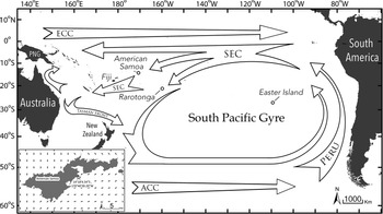
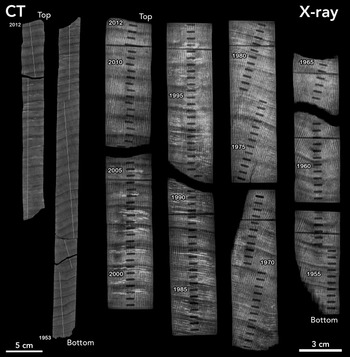
The coral core was collected from a reef off the southern side of Tutuila, American Samoa, near Matautuloa Point (14.30126ºS, 170.67758ºW) on 8 April 2012 (Figure 1). The core was extracted from the top of a Porites sp. colony at a depth of 10 m with a pneumatic drill and diamond bit coring device 3.8 cm in diameter. The recovered core was 70–72 cm in length, with no apparent hiatus in growth. The coral core was analyzed for calcification, density, and growth rates at the Woods Hole Oceanographic Institution’s Computerized Tomography (CT) Scanning Facility (Crook et al. Reference Crook, Cohen, Rebolledo-Vieyra, Hernandez and Paytan2013). The core was then slabbed with a double blade wet tile saw to a thickness of 7 mm, which was analyzed for density banding in X-ray images. Density bands (high- and low-density couplet) identified from both the CT scans and X-rays were used to estimate the age of the coral core and to create a robust chronology (Figure 2). The coral cores were sub-sectioned into 95 × 25 mm pieces using a diamond blade saw, sonicated three times in DI water for 10 min, dried overnight, mounted on an X-Y sample stage, and placed in a sealed Perspex chamber (under helium atmosphere) for Laser Ablation - Inductively Coupled Plasma Mass Spectrometry (LA-ICP-MS) analysis at the Marine Analytical Lab of University of California, Santa Cruz. A Photon Machines 193 nm ArF excimer laser and a Thermo X-series II quadrupole ICP-MS was used, following previously described methods (Sinclair et al. Reference Sinclair, Kinsley and McCulloch1998; Fallon et al. Reference Fallon, McCulloch, van Woesik and Sinclair1999), with samples bracketed by three standards (NIST 610, NIST 612, and JCP-1 [a Japanese ground coral standard]). Samples and standards were ablated with a scan speed of 40 μm·s–1 and a laser pulse rate of 10 Hz (1 pulse per 4 μm). The elemental ratios from parallel tracks along the major growth axis and perpendicular to growth bands were smoothed to an approximate resolution of 1 data point per 150 μm using a 20-point running median to remove outliers, followed by a 10-point running mean to reduce data volume (Jupiter et al. Reference Jupiter, Roff, Marion, Henderson, Schrameyer, McCulloch and Hoegh-Guldberg2008). For visualization, data are plotted as monthly moving mean values (Supplemental Figure S1).
Map of selected locations of the tropical-subtropical South Pacific Ocean with ocean current structure for the South Pacific Gyre, a region of the South Pacific that is constrained by the Equatorial Countercurrent (ECC) and the Antarctic Circumpolar Current (ACC). The 14C records from coral cores at these islands (American Samoa, Fiji, Rarotonga, and Easter Island) provide information on how the bomb-produced 14C signal is affected over time and by the mixing of water sources due to climate variability (ENSO), such as changes in the strength of the South Equatorial Current (SEC) and the consequent inclusion (14C-depleted) or exclusion of upwelled waters of the Peru Current to American Samoa.

Pictured as a CT scan (left) and an X-ray (right) is the slabbed coral core extracted from a reef off Matautuloa Point on the southern side of Tutuila, American Samoa. The continuous CT scan and X-ray show a clear banding pattern across the core with the chronology labeled every 5 yr from the annual band counting (high- and low-density couplet) in the X-ray image. The record begins at the collection date in 2012 and clearly covers regularly spaced bands through to 1953 for a total of 59 yr of growth. The banding structure was consistent through time in each core image with a mean annual growth rate of ∼1.2 cm·yr–1. The serial sampling from the micromill is seen as regularly spaced parallel channels (4–5 mm long) in the X-ray that were cut into the coral. The horizontal marks toward the top of each core segment in the X-ray image are an artifact of the indexing slots used for LA-ICP-MS placement and the white lines on the CT image show the laser scan paths.

In preparation for 14C analyses, each section of the slabbed coral core was sonicated 3 times in Milli-Q water for 5 min using a Branson 2510 sonicator. The extraction surface was faced downward during sonication to allow loose coral fragments and dust to vibrate free of the coral matrix. Slabs were thoroughly rinsed in between sonication steps and were finally air-dried in a clean, positive-pressure, laminar flow hood. A New Wave Research® micromilling machine (Elemental Scientific Lasers, LLC, Bozeman, Montana) with a 1.4 mm Brasseler® carbide cutter (H129E.11.014; Savannah, GA) was used to subsample the coral core for discrete 14C measurements. Three samples were extracted across each ∼1.2 cm (presumed) annual density band (yielding a sample interval of ∼4 mm·yr–1), which were equally spaced when possible, across the coral core (breaks in the core offset the regular interval in some places). As a result, the date of extraction was calculated based on the spacing within the density banding. Each sample consisted of a path that was 4–5 mm in length, cut 1.2 mm deep into the coral matrix, running perpendicular to the growth axis, and were not contiguous. Hence, each extraction path sampled ∼12% of each year (∼1.5 months) and may have missed actual high and low 14C values for the coral core time series during a given year, as opposed to contiguous months-wide samples that would average out high and low values. Collection of the powdered sample was carefully performed using a fine-tipped probe, onto wax paper, and into a clean polypropylene vial (0.6 mL snap-cap centrifuge tubes) with a target mass of ∼4–7 mg per sample.
In addition to the coral sample series, otoliths from juvenile snapper (collected from the waters of American Samoa; Supplemental Table S1) were analyzed for 14C by extracting core material (first year of growth). The same micromilling machine was used in a manner similar to other snapper studies of the Pacific Ocean (e.g., Andrews et al. Reference Andrews, Brodziak, DeMartini and Cruz2020a). Because age is far less in question for these young fish and reliable growth zone counting methods were employed, the calculated dates of formation were used as reference 14C measurements with other reference records (i.e., American Samoa coral 14C record).
The extracted coral and otolith samples were submitted as carbonate to the National Ocean Sciences Accelerator Mass Spectrometry Facility (NOSAMS) at Woods Hole Oceanographic Institution in Woods Hole, Massachusetts. Radiocarbon measurements were reported by NOSAMS as Fraction Modern (F14C), the measured deviation of the 14C/12C ratio from Modern. Modern is defined as 95% of the 14C concentration of the National Bureau of Standards Oxalic Acid I standard (SRM 4990B) normalized to δ13C VPDB (–19‰) in 1950 AD (VPDB = Vienna Pee Dee Belemnite geological standard; Coplen Reference Coplen1996). Radiocarbon results were corrected for isotopic fractionation using δ13C measured concurrently during AMS analysis and are reported here as date corrected Δ14C (Reimer et al. Reference Reimer, Brown and Reimer2004). Stable isotope δ13C measurements by a stable isotope mass spectrometer were made on a CO2 split taken from the CO2 generated through acid hydrolysis.
Several time-series analyses were performed on the coral core geochemistry data in order to evaluate the strength of the annual signal and its application to independently verify the chronology. The elemental ratios (Sr/Ca and Ba/Ca) from the two core tracks had mean depth spacing of 80 ± 57 µm (±1 SD) and a mean deviation (chronology) spacing of 2.6 ± 0.3 d (±1 SD). For each elemental ratio, the tracks were combined, sorted, and then interpolated to a uniform interval (time: 3-d; depth: 90 µm). Power spectral density (PSD) estimates were computed for the interpolated records using Welch’s method with a 1024-point Hamming window (3072 d) with 50% overlap. The δ13C measurements had a mean chronological spacing of 127 ± 30 d (±1 SD), with a minimum of 68 d and maximum of 282 d. This record was interpolated to a uniform 80-d interval and then a PSD was computed using a 64-point Hamming window (5120 d) with 50% overlap. Given the error associated with the core chronology, an expected range of ± 100 d around the annual period (366 d) was used to identify focal energy in the annual signal.
Sea-surface temperature (SST) was obtained from the National Oceanographic Atmospheric Administration’s (NOAA) 1/4° daily Optimum Interpolation gridded SST v2.1 (Huang et al. Reference Huang, Banzon, Freeman, Graham, Hankins, Smith and Zhang2020) for available years starting in 1982. The gridded SST was interpolated (two-dimensional linear) to the core location to obtain an SST time-series record.
RESULTS AND DISCUSSION
Coral Chronology
Dating of the American Samoa coral core with density band counting—assuming one year is represented by one high-low density band pair (Lough and Barnes Reference Lough and Barnes1990)—yielded 59 yr of growth that spanned the time of collection in 2012 to 1953 (Figure 2). The banding pattern observed in the coral CT and X-ray images was well-defined and uncomplicated leading to calculated mean growth rates of 1.12 ± 0.13 cm·yr–1 and 1.20 ± 0.02 cm·yr–1, respectively. These results were consistent with other Pacific coral (Porites spp.) records with annual growth rates of ∼1–1.5 cm·yr–1 (e.g., Guilderson et al. Reference Guilderson, Schrag, Goddard, Kashgarian, Wellington and Linsley2000; Prouty et al. Reference Prouty, Field, Stock, Jupiter and McCulloch2010, Reference Prouty, Storlazzi, McCutcheon and Jenson2014). To confirm these observations, an annual growth rate was calculated from the temporal coral geochemistry cycles within the error associated with the core band chronology. This spectral analysis captured strong annual periodicities from the Sr/Ca and Ba/Ca ratios, as well as δ13C data (Figure 3A, B, and C), that can be attributed to seasonal fluctuations in SST (e.g., Delong et al. Reference DeLong, Quinn and Taylor2007) and metabolic rates (e.g., Swart Reference Swart1983). Initial peak counting of the inferred annual geochemical signals underestimated the chronology by up to 4 yr; however, inclusion of additional smaller inflexions (changes in curvature) in the Sr/Ca data, visible across 2-yr periods, led to corroboration of the annual band counting to a lifespan of 58–59 yr (Figure 4). These muted Sr/Ca levels for some parts of the coral core may be attributed to minor annual temperature changes—the annual SST range for the Samoan Archipelago is small, ∼2–3ºC on average (∼27–30ºC; Brainard et al. Reference Brainard, Gove, Helyer, Kenyon, Mancini, Miller, Myhre, Nadon, Rooney, Schroder, Smith, Vargas-Angel, Vogt and Vroom2008; Pirhalla et al. Reference Pirhalla, Ransi, Kendall and Fenner2011), as reflected in a Sr/Ca annual range of less than 0.5 mmol·mol−1 (<3ºC; Supplemental Figure S2). The annual SST variability is likely lower at the collection depth of 10 m and on the southern side of Tutuila, in general, where waters were described as more mixed and less stratified than the northern side of the island (Brainard et al. Reference Brainard, Gove, Helyer, Kenyon, Mancini, Miller, Myhre, Nadon, Rooney, Schroder, Smith, Vargas-Angel, Vogt and Vroom2008). As a result, the Sr/Ca-SST relationship may be weaker when the temperature range is narrow, similar to what was observed in Guam where the average annual SST range was <1ºC (McCutcheon et al. Reference McCutcheon, Raymundo, Jenson, Prouty, Lander and Randall2015).
Power Spectral Density (PSD), f*S(f), estimates for (A) strontium:calcium (Sr/Ca) ratios, (B) barium:calcium (Ba/Ca) ratios, (C) stable carbon isotopes (δ13C), and (D) depth-based PSD (z-1*S(z-1)) for the Ba/Ca ratios. For (A–C), the x-axis is log10 frequency (f) in cycles per day, and for (D) the x-axis is log10 cycles per cm. The red dashed lines indicate the frequency window considered for the annual signal (period range of 366 ± 100 d). The gray shading indicates the 95% confidence intervals.

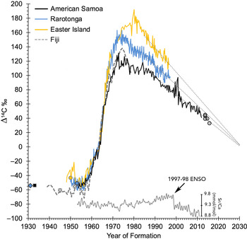
Plot of the 14C record from American Samoa (1953–2012) with other regional coral records from the South Pacific Gyre (Fiji, Rarotonga and Easter Island; Toggweiler et al. Reference Toggweiler, Dixon and Broecker1991; Guilderson et al. Reference Guilderson, Schrag, Goddard, Kashgarian, Wellington and Linsley2000; Biddulph et al. Reference Biddulph, Beck, Burr and Donahue2006). The density band counting performed on the American Samoa coral was corroborated with annual strontium:calcium (Sr/Ca) peaks (8.8–9.8 mmol·mol-1) that can be attributed to annual SST changes (range of ∼27–30ºC). The 14C levels associated with a recovery from the 1997–1998 ENSO event function as a regional marker that can be timed to ocean climate patterns. Post-peak 14C levels for each coral record exhibit a monotonic decline after 1985 that appear to converge near 2030 (Sen’s slope: American Samoa = –2.42, Rarotonga = –2.77, and Easter Island = –3.42 ‰·yr–1). Fish otolith 14C measurements (open grey circles in 2013–2015) follow the declining trend exhibited by the American Samoa coral record (Supplementary Table 1). Prebomb 14C levels recorded in shell and coral fragments among locations were consistent with each regional coral record (black square = American Samoa, grey X = Fiji, blue diamond = Rarotonga, and yellow circle = Easter Island; Petchey et al. Reference Petchey, Anderson, Zondervan, Ulm and Hogg2008).

To further evaluate the relationship between the seasonal SST and these ratios, the magnitude-squared coherence (Cxy) was computed for the records cross-spectra. The coherence of annual periodicity was robust between SST and Ba/Ca (Cxy = 0.45, in phase) and moderate between SST and Sr/Ca (Cxy = 0.21, 180º out of phase). Therefore, the PSD was computed for the depth-based Ba/Ca record to independently estimate a growth rate. A conversion of 3.12 × 10⁻³ cm·d–1 was used to set the corresponding annual signal range for the depth-based PSD. Use of core depth instead of band counting indicated the annual Ba/Ca variance could be used to determine a growth rate of 1.28 ± 0.12 cm (Figure 3D), similar to the linear extension rates calculated from the CT and X-ray analyses (Prouty and Andrews Reference Prouty and Andrews2020).
One of the most prominent features of the Sr/Ca time series from the American Samoa coral core is a shift in temperature between 1998 and 1999 with an elevated seasonal 14C response. During this period, Sr/Ca ratios decreased from 9.79 to 9.12 mmol·mol–1 in less than 1 yr, indicating an SST increase of 3.5ºC (Sr/Ca-SST calibration from 30-d average of interpolated SST data near Fatu Rock, Tutuila (OISST v2.1; Huang et al. Reference Huang, Banzon, Freeman, Graham, Hankins, Smith and Zhang2020)). The calibration (y = –5.2067x + 76.516; r = 0.732) was applied down core for the Sr/Ca-derived SST record (Supplemental Figure S2). This increase in temperature appears robust because the observed Sr/Ca decrease was detected in two separate LA-ICP-MS tracks, this period of coral growth was intact with no breaks in skeletal structure, and the OISST v2.1 data recorded a concomitant SST increase of 3.1ºC for the region (mid-1998 and early-1999). Within a few months of this well-documented warming event (1997–98 El Niño), there is a significant increase in Δ14C to 91.0‰ in mid-1999 followed by a strong oscillation of ∼30–40‰ in year 2000 and a Δ14C maximum of 97.1‰, yielding a positive deviation of ∼25‰ from a mean post-peak decline Δ14C value of 71.6 ‰ (Figure 4). The implications of this shift are discussed below.
Climate Variability and 14C
The timing of the events described above indicates the distinct changes in Δ14C may be in response to the termination of the 1997–98 El Niño event—a recovery to La Niña conditions that would facilitate warming in the Samoan Archipelago (Pirhalla et al. Reference Pirhalla, Ransi, Kendall and Fenner2011). This response is defined as a shift of the South Pacific Convergence Zone (SPCZ) toward the southwest, away from its average position crossing the Samoan Archipelago (175ºW and 15–20ºS; Gouriou and Delcriox Reference Gouriou and Delcriox2002), leading to a decreased influence from higher salinity SEC waters (Linsley et al Reference Linsley, Kaplan, Gouriou, Salinger, deMenocal, Wellington and Howe2006), which would be expected to increase 14C levels due a greater input from SPG waters and reduced influence from upwelled eastern boundary current waters from the Peru Current (Toggweiler et al. Reference Toggweiler, Dixon and Broecker1991). During the preceding El Niño event, a reversal of trade winds and deeper thermocline may have facilitated accumulation of 14C-enriched surface waters in the eastern Pacific (Guilderson and Schrag Reference Guilderson and Schrag1998). These enriched 14C surface waters could have been transported westward in the SEC to the Samoan Archipelago as a surge 12 mo later, assuming current speeds between 25–30 cm·s–1 as measured in the region for the SEC during ENSO conditions (Kendall et al. Reference Kendall, Poti, Wynne, Kinlan and Bauer2011). It is also important to note that Tutuila is in a unique location, situated at an average position for the SPCZ and a salinity front—shown to exhibit both short and long term atmospheric and ocean climate changes (Lindsley et al. Reference Linsley, Kaplan, Gouriou, Salinger, deMenocal, Wellington and Howe2006, Tangri et al. Reference Tangri, Dunbar, Linsley and Mucciarone2018)—that may complicate interpretation of annual 14C cycles, including an out-of-phase annual 14C cycle relative to SST observed for Rarotonga through the 1980s and 1990s (Guilderson et al. Reference Guilderson, Schrag, Goddard, Kashgarian, Wellington and Linsley2000). Weakening and strengthening of the SEC according to ENSO events, coupled with seasonal changes in SST and local upwelling, may be the basis for mixed ENSO responses in this region. It is also important to consider that differences in 14C levels for tropical and subtropical waters are decreasing as post-peak levels in each region converge over time in response to the loss of bomb-produced 14C to deep water and as the ocean becomes a net 14C source to the atmosphere (Figure 4)—this crossover between ocean and atmosphere occurred near the year 2000 for the North Pacific Gyre (NPG) (Andrews et al. 2016c) and was shown as a 10-yr period of coincidence before overtaking atmospheric levels in 2010 for the Coral Sea (Wu et al. Reference Wu, Fallon, Cantin and Lough2021). Hence, contrasting 14C levels for waters advected from western equatorial sources relative to SPG sources should have less contrast over time.
The 14C measurements from the American Samoa coral core provide a time series that is consistent with other regional records with some notable differences across the SPG (Figure 4). The 14C levels during the pre-bomb period (1953–1956) were depleted with a mean of Δ14C = –53.4 ± 2.6‰ (n = 10), consistent with a shell collected in 1933 at American Samoa (Δ14C = –53.7‰; Petchey et al. Reference Petchey, Anderson, Zondervan, Ulm and Hogg2008). Pre-bomb levels were similar for the same period at Rarotonga (Δ14C = –53.4 ± 4.4‰, n = 71; Guilderson et al. Reference Guilderson, Schrag, Goddard, Kashgarian, Wellington and Linsley2000), which was also consistent with shell and coral collected in 1931 and 1953 (Δ14C = –54.2 and –50.9‰ respectively; Petchey et al. Reference Petchey, Anderson, Zondervan, Ulm and Hogg2008) and the extended mean of Δ14C = –56.1 ± 4.5‰ (n = 124, 1950–1956; Guilderson et al. Reference Guilderson, Schrag, Goddard, Kashgarian, Wellington and Linsley2000). Pre-bomb Δ14C values were elevated at Easter Island for the same 1953–1956 period (Δ14C = –49.2 ± 5.7‰, n = 10), likely due to pooling effects of gyre waters, and while the sample size was smaller, pre-bomb Δ14C Fiji values were lower (Δ14C = –65.0 ± 6.1‰ n = 3) and consistent with coral and shell sample collected in 1945 and 1952, respectively (Δ14C = –55.4 and –60.5‰; Petchey et al. Reference Petchey, Anderson, Zondervan, Ulm and Hogg2008). In contrast, Easter Island Δ14C levels from 1949 to 1951 were elevated relative to other pre-bomb measurements (approaching –20‰ in 1951; Biddulph et al. Reference Biddulph, Beck, Burr and Donahue2006). The Easter Island 14C-enrichment reflects its location near the SPG center where local convergence of surface waters is less influenced by upwelled 14C-depleted waters on the gyre margins (Broecker and Peng Reference Broecker and Peng1982). A similar observation was made at Fanning Island in the Central Equatorial Pacific (3.87°N, 159.32°W), but the timing and duration (1947–1956) of the enrichment was different and attributed to a long-term shift in the Pacific Decadal Oscillation (PDO; Grottoli et al. Reference Grottoli, Gille, Druffel and Dunbar2003). The offset observed for the Easter Island 14C record may be more specifically linked to a strong Southern Oscillation recorded for 1949–1951 (Trenberth Reference Trenberth1984; Keppene and Ghil Reference Keppenne and Ghil1992; Commonwealth of Australia 2021). This observation is further supported by an elevated 14C measurement from an Easter Island shell collected in 1950 (Δ14C = –43.1‰; Petchey et al. Reference Petchey, Anderson, Zondervan, Ulm and Hogg2008). This event is also correlated with SST data from coral δ18O records at Rarotonga, Moorea and New Caledonia and may be related to a shift in the SPCZ where a similar response was not observed at Fiji (Linsley et al Reference Linsley, Kaplan, Gouriou, Salinger, deMenocal, Wellington and Howe2006). Unfortunately, the American Samoa coral core begins in 1953 and does not include this event.
For American Samoa, the bomb-produced 14C rise began in 1957 and increased steadily to a maximum in the early 1970s. This rise time is similar to most coral records across the tropical-subtropical South Pacific with American Samoa, Rarotonga, Easter Island, and Fiji rising at similar rates (15.0, 15.5, 15.5, and 15.9 ‰·yr–1, respectively) through the decade of most rapid rise (1958–1968), although there is a departure in 1966 of the American Samoa record to an attenuated peak (Δ14C = 131 ‰ in 1972 cf. Δ14C = 163 ‰ in 1974 for Rarotonga). Peak values across the three selected locations in the SPG follow a pattern that is similar to observations in the NPG, where coral bomb 14C records trend toward more elevated peak values as the location becomes more centrally located in gyre waters (e.g., Andrews et al. Reference Andrews, Asami, Iryu, Kobayashi and Camacho2016a, Reference Andrews, Siciliano, Potts, DeMartini and Covarrubias2016c, Guilderson et al. Reference Guilderson, Schrag, Druffel and Reimer2021). For example, Rarotonga is ∼1300 km southeast of American Samoa and more closely situated within the SPG, thereby influenced by greater surface water residence times and exposure of the mixed layer for air-sea diffusion of 14CO2. In comparison, the coral 14C record from American Samoa was expected to be more depleted due to mixing of upwelled waters from the eastern equatorial Pacific transported via the SEC (Broecker and Peng Reference Broecker and Peng1982; Broecker et al. Reference Broecker, Peng, Ostlund and Stuiver1985). This pattern is similar to what was observed for the NPG from a Hawaii Island coral 14C record located at the southern end of the Hawaiian Archipelago and at the northern edge of the North Equatorial Current (Andrews et al. Reference Andrews, Siciliano, Potts, DeMartini and Covarrubias2016c; Gulderson et al. Reference Guilderson, Schrag, Druffel and Reimer2021). In contrast, the 14C record from Easter Island, being centrally located in the SPG where downwelling dominates, is expected to be the most elevated due to the greatest residence time for the mixed layer, as confirmed by elevated DI14C values measured in the region (Key et al. Reference Key, Kozyr, Sabine, Lee, Wanninkhof, Bullister, Feely, Millero, Mordy and Peng2004). The overall progression from an attenuated bomb 14C signal at American Samoa to successively greater peak values at Rarotonga and Easter Island are in agreement with the bi-modal distribution of 14C across the tropical-subtropical Pacific Ocean and the SPG (Linick Reference Linick1980; Key et al. Reference Key, Kozyr, Sabine, Lee, Wanninkhof, Bullister, Feely, Millero, Mordy and Peng2004). This spatial pattern is consistent with surface ocean measurements from programs like WOCE and GEOSECS that demonstrated how the distribution of bomb radiocarbon in the surface ocean is highly latitude-dependent, with the greatest Δ14C values centered at approximately 30°N and 30°S (Linick Reference Linick1980; Broecker et al Reference Broecker, Peng, Ostlund and Stuiver1985; Nydal Reference Nydal2000). The delayed peak at Easter Island can be attributed to its location within the warm, nutrient-poor subtropical water of the anticyclonic SPG (Reid et al. Reference Reid, Brinton, Fleminger, Venrick and McGowan1978; Moraga et al. Reference Moraga, Valle-Levinson and Olivares1999). Nonetheless, the regional post-peak 14C signal for each record follows an expected monotonic decline—a pattern that is punctuated with inflexions for some periods but overall continues to decrease over time—for which the decrease in coral 14C values is a function of air-sea diffusion and regional oceanography.
Post-peak Δ14C levels decline episodically from the mid-1970s to the mid-1980s for the records closer to equatorial waters (Fiji, Rarotonga, and American Samoa). After each peak there is a rapid 14C decline of 30–34 ‰ in 3–6 yr to a more moderate decline for a period of ∼10 yr beginning in the late-1970s and ending in the late-1980s. While there is no information after 1978 for Fiji, the record for Rarotonga declines at ∼1.7‰ per year as American Samoa comes close to leveling off at ∼0.3‰ per year, similar to observations made for corals in the North Pacific during the same period (Andrews et al. Reference Andrews, Siciliano, Potts, DeMartini and Covarrubias2016c, Guilderson et al. Reference Guilderson, Schrag, Druffel and Reimer2021). This long-period event is well-correlated in time with shifts observed in sea level pressure as a strong PDO for the North Pacific (1976–1988; Trenberth and Hurrell Reference Trenberth and Hurrell1994; DiLorenzo et al. Reference Di Lorenzo, Schneider, Cobb, Franks, Chhak, Miller, McWilliams, Bograd, Arango, Curchitser, Powell and Riviére2008), which may be responsible for the effect noted above on the northern edge of the SPG as is reflected in the Rarotonga and American Samoa coral 14C records. After this period, each 14C record begins to follow what may be a path of convergence despite episodic events that shift 14C levels for a few years, like the significant 14C pulse in the American Samoa record associated with the 1997–98 ENSO event. Despite these long-term inflexions and subannual pulses, a nonparametric (Mann-Kendall test) assessment for a monotonic trend provided Sen’s slopes for the declining trends of –3.42 ‰·yr–1 (Easter Island), –2.77 ‰·yr–1 (Rarotonga), and –2.42 ‰·yr–1 (American Samoa), all of which may converge near the year 2030 (Figure 4). This decline is expected from the dilution and continued entrainment of 14C-depleted waters from the lower thermocline (Jenkins et al. Reference Jenkins, Elder, McNichol and von Reden2010), but the trend should also begin to reach an asymptote for surface waters as bomb-produced 14C is sequestered from the air-sea environments and the tropical and subtropical seas approach pre-bomb equilibrium levels near –50‰. The American Samoa record adds to the evidence that 14C in the tropical-subtropical waters of the Pacific are beginning to merge in the post-peak period, which provides opportunities to determine the age of short-lived marine organisms that provide an archive of 14C variability through time.
Bomb 14C Dating
One of the widest applications of bomb-produced 14C as a tool in age determination is with 14C stored in the otoliths (ear stones) of fishes. Otoliths are composed of calcium carbonate (aragonite) which calcify from marine DIC (Campana Reference Campana1999). This inert non-skeletal structure is often used to provide estimates of age for fishes from purported annual growth zone structure, usually seen as growth rings in otolith cross sections, that is based strictly on visual interpretation and requires some form of validation (Campana Reference Campana2001). The bomb-produced 14C rise period is typically used as a temporal reference in determining the validity of an age estimate by alignment of 14C measurements within the first year of otolith growth to a regional bomb 14C reference. Because hermatypic (reef building) coral also sequester DIC as its carbon source for calcification, both the otolith and coral 14C measurements can be compared directly for temporal alignment, or in some cases misalignment for which ages were not accurate. An example of a subtropical Pacific age validation study using otoliths and coral was on Hawaiian pink snapper (Pristipomoides filamentosus)—the estimated lifespan was thought to be 5–18 yr, with drastically different growth parameters, but was actually more than 40 yr based on bomb 14C dating (Andrews et al. Reference Andrews, DeMartini, Brodziak, Nichols and Humphreys2012). This is just one of many age validation studies throughout tropical-subtropical Pacific that have utilized the 14C rise period as a time-specific marker with results that have provided age-validated life history characteristics that are essential in fisheries science (e.g., Kalish Reference Kalish1993; Andrews et al. Reference Andrews, Kalish, Newman and Johnston2011, Reference Andrews, Choat, Hamilton and DeMartini2015, Reference Andrews, DeMartini, Eble, Taylor, Lou and Humphreys2016b, Reference Andrews, DeMartini, Brodziak, Nichols and Humphreys2019a, Reference Andrews, Brodziak, DeMartini and Cruz2020a).
The apparent convergence of coral 14C records across the SPG provides an indication that more recently collected fish can be aged using the post-peak 14C decline. As was demonstrated in a fortuitous study of a grander blue marlin (Makaira nigricans; 1245 lbs., 565 kg) captured in Hawaii, broad-scale convergence of 14C records within the tropical-subtropical Pacific led to 14C decline limits through time and a reliable age estimate of ∼20 yr (Andrews et al. Reference Andrews, Humphreys and Sampaga2018). An apparent misalignment in time for measured otolith 14C values from the coral 14C decline can in some cases be explained by oceanography and early life history, as was attributed to a consistent offset of Pacific bluefin tuna (Thunnus orientalis) birth years (Ishihara et al. Reference Ishihara, Abe, Shimose, Takeuchi and Aires-Da-Sliva2017)—these values were within the constraints of the collective coral 14C records of the North Pacific and provided strong support for the age reading protocol to ∼30 yr. In addition, an age reading protocol was refined based on a wide offset of otolith 14C values from the regional decline reference and resulted in validated life history characteristics for a deep-water snapper that were drastically different from an initial otolith age reading interpretation (Andrews and Scofield Reference Andrews and Scofield2021). In each case, the circumstances are specific to the early life history of the species and regional oceanography but the differences in 14C levels for the tropical-subtropical Pacific across time and space are now reduced and appear to be converging. For the SPG, a set of otoliths from snapper collected from the Samoan Archipelago show evidence of a continued decline (Supplementary Table 1; Figure 4). These juvenile fish confirm that the validity of age estimates for adults of these species—collected from American Samoa and other parts of the archipelago—can be tested using the 14C decline and further demonstrates that constraints can be placed on age for specimens across the SPG (e.g., a measurement of 60‰ is limited to birth years of ∼2006–2013). While this level of precision is not optimal if one fish were aged in this manner (potential age range of ∼7–14 yr), a proper age validation study must include numerous individuals that have been estimated for age using a consistent manner of growth zone counting (a well-defined age reading protocol) for specimens that cover the full lifespan. An example is from an age validation study of tuna from the Gulf of Mexico where numerous fish were aged with a well-defined protocol leading to a series of birth years that were in alignment with the coral 14C record—these species can live 2–3 times longer than previously estimated (Andrews et al. Reference Andrews, Pacicco, Allman, Falterman, Lang and Golet2020b). Furthermore, this declining 14C relationship should be supported with measurements from juvenile fish (known dates of formation) that cover the adult birth year timespan. For example, if a species is estimated to live 20 yr and adults of all sizes are available from a collection year of 2020, then use of juveniles (e.g., age-0 fish) collected across the span of calculated adult birth years (2000 to 2020) can provide direct evidence that adult otolith cores (the juvenile portion of the otolith) will align with the 14C reference if the age reading protocol is accurate. Alternatively, a full study can be facilitated with limited juvenile collections or otolith edge material of young fish that cover a portion of the decline period, with the assumption that the trend of otolith 14C alignment continues in unison with the coral 14C reference (i.e., Andrews Reference Andrews2020; Barnett et al. Reference Barnett, Thornton, Allman, Chanton and Patterson2018; Andrews et al. Reference Andrews, Pacicco, Allman, Falterman, Lang and Golet2020b, Andrews and Scofield Reference Andrews and Scofield2021). Use of the post-peak bomb 14C decline has also evolved with a novel line of research that uses core material of fish eye lenses to validate age (Patterson et al. 2020) and in the use of new technology (laser ablation accelerator mass spectrometry) to trace continuous bomb 14C signals within an otolith (Andrews et al. Reference Andrews, Yeman, Welte, Hattendorf, Wacker and Christl2019b).
CONCLUSION
The bomb 14C record from a coral core at American Samoa provides the longest chronology for the SPG by extending the record from the pre-bomb period to 2012. A comparison with other SPG coral records highlights the role of position within the gyre to influence the timing and magnitude of the bomb-produced 14C peak and decline. The effects of the strong 1997–1998 ENSO event that were documented as a series of 14C peaks that correspond to the intrusion of warmer waters during the following La Niña years highlight the oceanographic complexity of this location during large scale climate shifts, such as the broad scale drivers of the position of the SPCZ (e.g., Folland et al. Reference Folland, Renwick, Salinger and Mullan2002). The American Samoa 14C chronology, when combined with other coral records, provides evidence for convergence of 14C levels through the decline period in the SPG. This observation reinforces the perspective that recently collected fishes and other organisms of the tropical-subtropical marine mixed layer with conserved skeletal and non-skeletal structures can be aged using these records as a temporal reference and that bomb 14C dating is no longer tied strictly to the initial 14C rise period in the 1950s and 1960s as a temporal reference.
ACKNOWLEDGMENTS
We are very grateful to C. Young and D. Merritt for assistance with the core extraction (NOAA R/V Hi’ialakai), K. Rose (WHOI) and A. Cohen (WHOI) for CT analysis, C. Gallagher (UCSC) for LA-ICP-MS, the staff of VCA University Animal Hospital #468 in Honolulu for the coral X-ray (L. Iboshi, J.K.W. Ng, M. Malta, and C. Sharp), and W. Beck (U. Arizona) for providing an internal review and two anonymous reviewers for providing constructive input. Thanks to R. Humphreys (PIFSC), the Pacific Islands Fisheries Science Center, and the USGS Coastal and Marine Hazards and Resource Program’s Coral Reef Project for project support. The coral core extraction was performed under the American Samoa Department of Marine and Wildlife Resources Scientific (Permit Series No. 2012-57), Fagatele Bay National Marine Sanctuary Research (Permit No. FBNMS-2011-002), National Park of American Samoa research (Permit No. NPSA-2012-SCI-0001), and Pacific Reefs National Wildlife Refuge Complex (Special Use Permit No. 12521-10001). Fish specimens were collected by the Pacific Islands Fisheries Science Center under Project SE-16-01 and data were accessed via the NOAA National Centers for Climate Information (https://www.ncdc.noaa.gov/paleo-search/study/27541). Any use of trade, product, or firm names is for descriptive purposes only and does not imply endorsement by the U.S. Government. Additional geochemical data to support this project can be found in Prouty and Andrews (Reference Prouty and Andrews2020) and in the Supplemental Material.
Supplementary material
To view supplementary material for this article, please visit https://doi.org/10.1017/RDC.2021.51