INTRODUCTION
The 2–12 m high human-made mounds that were built as dwelling places (tell), burial sites (kurgan), and guard mounds from the late Neolithic until the Middle Ages are special landscape and cultural historical values of the Great Hungarian Plain in the Carpathian Basin (Raczky Reference Raczky1991; Csányi Reference Csányi1999). Their original number could have been as many as 25,000 (Bede Reference Bede2014), however, due to the artificial damage of the last centuries fewer than 2000 remain today (Tóth and Tóth Reference Tóth and Tóth2004).
Mound explorations in the Great Hungarian Plain to date (Ecsedy Reference Ecsedy1979; Bóna Reference Bóna1992; Dani and Horváth Reference Dani and Horváth2012) have revealed that the majority of Hungarian mounds were built by the people of Yamnaya Culture of the Late Copper Age–Early Bronze Age (3300–2600 BC). However, other nomadic cultures like Scythians (900–100 BC), Sarmatians (600 BC–400 AD), Thracians (800 BC–100 AD), Hungarians (700 BC–Medieval) and Cumans (1300 BC–Medieval) populating the Central Asian and Eastern European steppes, thus the Great Hungarian Plain of the Carpathian Basin as well, also built burial mounds for the noble people (Demkin et al. Reference Demkin, Kashirskaya, Demkina, Khomutova and El’tsov2008; Rowinska et al. Reference Rowinska, Sudnik-Wójcikowska and Moysiyenko2010; Sudnik-Wójcikowska and Moysiyenko Reference Sudnik-Wójcikowska and Moysiyenko2012; Deák et al. Reference Deák, Tóthmérész, Valkó, Sudnik-Wójcikowska, Moysiyenko, Bragina, Apostolova, Dembicz, Bykov and Török2016). Studying only the outer morphological appearance of mounds in the Great Hungarian Plain built by various cultures over long millennia, it is difficult to decide which culture built which mounds and for what purpose.
Since only a fraction of the almost 2000 mounds currently existing in Hungary has been exposed so far (Ecsedy Reference Ecsedy1979; Bóna Reference Bóna1992; Csányi Reference Csányi1999; Dani and Horváth Reference Dani and Horváth2012) the available information is relatively scant. The complete archaeological excavation of the mounds yields the most information on the age and method of mound building and on the purpose of the mounds. Such excavations are not only expensive and time-consuming but frequently result in irreversible consequences: the shape and appearance of the mounds in the landscape could be damaged and it is possible that the valuable loess grassland vegetation on top of the mounds could be completely destroyed. Mounds in Hungary have been protected since 1996 due to their special landscape, botanic, and cultural historical values. As a result, archaeological geological research that attempts to clear the building circumstances of the studied object without archaeological excavation, only on the basis of natural scientific methods, has become increasingly popular in recent years (Molnár et al. Reference Molnár, Joó, Barczi, Szántó, Futó, Palcsu and Rinyu2004; Barczi et al. Reference Barczi, Golyeva and Pető2007; Shishlina et al. Reference Shishlina, Zazovskaya, van der Plicht, Hedges, Sevastyanov and Chichagova2009; Morgunova and Khokhlova Reference Morgunova and Khokhlova2013; Bede et al. Reference Bede, Csathó, Czukor and Sümegi2015; Barczi Reference Barczi2016). Following this trend, the primary aim of the present paper is to aquire as much archaeological geological information on the studied mounds as possible, using the most up-to-date earth scientific methods, while causing minimal disturbance. In particular, the age and the original purpose of the mounds were attempted to be identified. Our secondary aim was to determine the methods of mound building. This aim was carried out by pedological analysis of the drilling core and geo-electric examination in the absence of archaeological excavations. Lacking archaeological excavations and finds (bones, ceramics), the age of building of the mounds can be determined from the radiocarbon age of the buried soils under the mounds (Pessenda et al. Reference Pessenda, Gouveia and Aravena2001; Molnár et al. Reference Molnár, Joó, Barczi, Szántó, Futó, Palcsu and Rinyu2004; Molnár and Svingor Reference Molnár and Svingor2011; Pető et al. Reference Pető, Baklanov, Tóth, Tóth and Barczi2016). Such buried paleosols preserve soil structures characteristic at the time of the building of the mounds and their physical and chemical composition differ significantly from those of the recent soils, which developed farther away from the mounds (Alexandrovskiy Reference Alexandrovskiy1996; Aleksandrovskiy et al. Reference Alexandrovskiy, van der Plicht, Belinskiy and Khokhlova2001; Barczi Reference Barczi2016).
METHODS
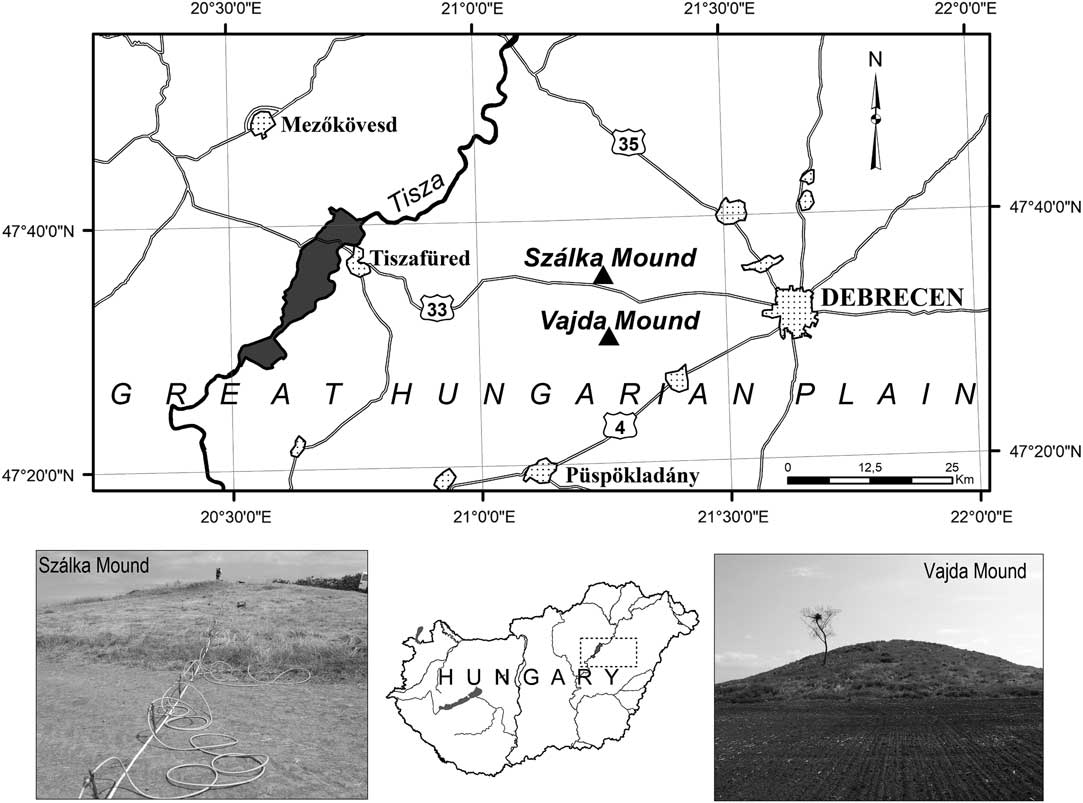
Two archaeologically unexplored mounds were studied in the areas of Hortobágy (Szálka Mound) and Hajdúság (Vajda Mound) regions, which are located 8 km apart (Figure 1). The field research of the ex lege protected mounds was conducted with the permission of the Hortobágy National Park Directorate (license number: 657-2/2016).
Geographical locations of the studied mounds. (Image designed by C Tóth.)
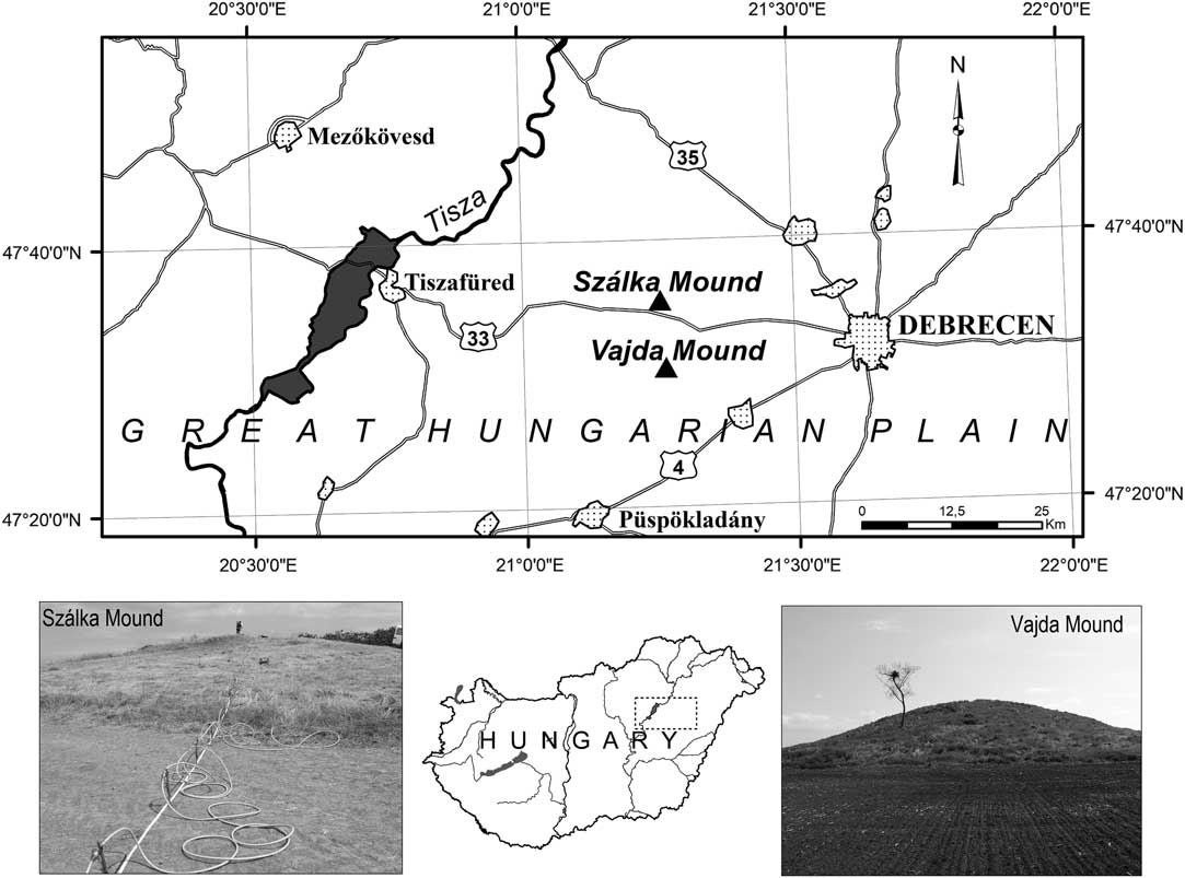
The 3.7-m-high Szálka Mound (94.3 m asl) has an elliptical base and is located on the levee of Szálka Creek in the eastern grassland of Hortobágy (47°34′35′′N, 21°14′38′′E). A border ditch is found on its top marking the former boundary between Debrecen and Balmazújváros since medieval times. Nowadays the triangulation point on the top of the mound records the border of Hortobágy, Nagyhegyes and Balmazújváros settlements. The mound is covered by strongly degraded loess grassland while the foot of the mound is covered by a saline grassland used as pastoral land. The 8.2 m high intact Vajda Mound (98.5 m asl) on the levee of Kösely River at the edge of the loess area of Hajdúság (47°30′25′′N, 21°15′39′′E) has an almost symmetrical, circular base. The chernozem soils in its surroundings have been cultivated for centuries. The mound was a small wooded area with acacia until 2011 but following the deforestation a strongly weedy grassland developed on it. No pit holes can be seen at the foot of either mound.
In the course of field work the relief conditions of the mounds were mapped using a Stonex S9 RTK GPS. The coordinates of almost 500 points were recorded for each mound and using the data a 3D surface model was created for each mound using the software Surfer 11. Using the model the most important morphometric parameters of the mounds were determined (area of the base, slope angles, height, surface, and volume).
Shallow boreholes were drilled using an Eijkelkamp undisturbed sampler near the highest point of the mounds and on their sides in order to determine their inner structure, building material, and the age of building. These boreholes were drilled down to the bedrock (loess) of the mounds crossing the buried former soil level. Control topsoil samples (0–20 cm) were taken from the least disturbed, uncultivated surroundings (balk, ancient grassland) of the mounds for age determination. Boreholes were sampled by 10 cm for sedimentological analyses. Grain size distribution of the samples were determined using wet sieving (2–0.2 mm fraction) and the pipette method (<0.2 mm fraction) (Pansu and Gautheyrou Reference Pansu and Gautheyrou2006). Carbonate content was measured using Scheibler’s calcimeter (Chaney et al. Reference Chaney, Slonim and Slonim1982). The organic carbon content was determined by wet oxidation with K2Cr2O7, followed by Fe(NH4)2(SO4)2 titrimetry (Ponomareva and Plotnikova Reference Ponomareva and Plotnikova1980). The pHH2O, pHKCl were measured in 1:2.5 soil:water suspension with standard glass electrodes.
Apart from sedimentological and pedological analyses geo-electric measurements were performed in the case of both mounds along N–S and E–W profiles. Geo-electric measurements were made using an AGI SuperSting R8 direct current measurement device with eight channels. The aim of the geo-electric analysis was to study the top 10 m sediment layer. For this, a “multiple gradient” electrode arrangement was used. At one time, 84 electrodes were used with 1-m spacing in the course of the measurements. During geo-electric measurements the specific resistance distribution of the sediments can be determined along a line. This method is sensitive to two properties of sediments, the grain size distribution and moisture content, respectively. The wet sediment has a low resistivity, while the dry is higher. The specific resistance of clay is between 1–15 Ωm, the silt 15–35 Ωm, the wet sand 35–100 Ωm, while the dry sand 50–1000 Ωm. The advantage of this method is that it works in almost every environment and is not sensitive to surrounding landmarks. The disadvantage however, is that the measurement results cannot be interpreted always clearly and with depth the resolution will deteriorate rapidly. Data processing was carried out using the software Res2DInv. Furthermore, magnetic susceptibility was measured along the borehole in Szálka Mound using a Bartington MS2 device.
The age of the kurgans was determined from the radiocarbon age of the buried soil layers measured by AMS technique at the ICER Centre at ATOMKI, due to the lack of archaeological findings that would have enabled accurate age determinations. At the HEKAL AMS Laboratory they have removed the carbonate content of each soil samples using acid leaching (2 g of soil was tretated by 1% HCl acid in test tubes for 4 hr at 75ºC temperature). Bulk soil sample were dried and 0.2 g of each were oxidized in quarz test tubes using the HEKAL on-line combustion system (Jull et al. Reference Jull, Burr, Beck, Hodgins, Biddulph, Gann, Hatheway, Lange and Lifton2006; Molnar et al. 2013.). Along the two-step combustion procedure at first the non-charred organic matter were removed by combustion at 400ºC (“low temperature”) in a pure O2 atmosphere. Afterwards, a second combustion of the same soil sample (kept in vacuum since L-temp combustion) at a higher temperature (800ºC) by a new addition of pure O2 gas to complete the combustion of the charred carbon fraction of the soil samples (hereafter “H-fraction”). The H-fraction CO2 was also cryogenically cleaned and the C-yield determined. Both L- and H-fraction CO2 of the same soil sample were graphitized by the sealed tube Zn-graphitization method (Rinyu et al. Reference Rinyu, Molnár, Major, Nagy, Veres, Kimák, Wacker and Synal2013) and 14C/12C ration analysed by the EnvironMiCADAS system at HEKAL (Molnár et al. Reference Molnár, Janovics, Major, Orsovszki, Gönczi, Veres, Leonard, Castle, Lange, Wacker, Hajdas and Jull2013). Conventional radiocarbon ages of the charred C fraction (H-fraction) were reservoir age-corrected using the H-fraction apparent 14C ages of undisturbed recent top soil samples form the vicinity of each studied kurgans. We applied the reservoir effect corrected 14C age of H-fractions for the soil burial time determination. Soil reservoir age corrected conventional 14C age of the paleosol layers were converted to calendar ages using the Calib software (version Calib Rev 7.0.4) and the IntCal13 calibration curve (Reimer et al. Reference Reimer, Bard, Bayliss, Beck, Blackwell, Ramsey, Buck, Cheng, Edwards, Friedrich, Grotes, Guildersn, Haflidason, Hajdas, Hatté, Heaton, Hoffmann, Hogg, Hughen, Kaiser, Kromer, Manning, Niu, Reimer, Richards, Scott, Southon, Staff, Tourney and van der Plicht2013). Calibrated ages are reported as age ranges at the 2-sigma confidence level (95.4%).
RESULTS
Szálka Mound (Hortobágy)
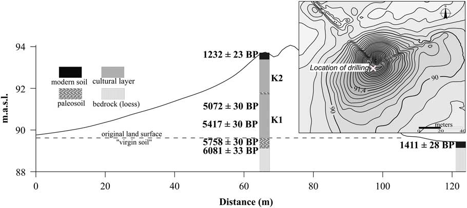
Szálka Mound can be regarded as a medium-sized mound in Hungary based on its morphometric parameters. The 3.7-m-high mound with the ground area of 3224 m2 was built from 3351 m3 of soil. The eight layers of the mound were drilled by a 5-m-deep borehole from the top of the mound down to the bedrock (Figure 2).
Contour map of Szálka Mound and the results of the stratigraphic analyses. (Image designed by C Tóth.)
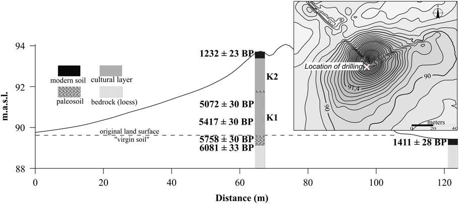
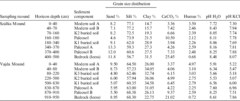
On the top of the mound a dark colored (10YR 4/1), crumb-structured modern A layer was formed (0–40 cm) the age of which is 1232±23 BP. The dark brown (10YR 3/1) modern B layer (40–70 cm) has a higher lime content and it is slightly crumb-structured (Table 1). The modern soil shows signs of a chernozem soil. Under the modern soil between the depths of 70 cm and 340 cm artificially compiled mound material with 2–3% humus and 3–9% lime content (natural calcite), mixed structure, silt dominance and moisture content increasing downwards is found. Based on the sedimentological, magnetic susceptibility and geo-electric analyses, the mound was built probably in two phases. In the first phase (K1, 180–340 cm) layers A and B of the surrounding chernozem soil were compiled. This resulted in the building of an around 1.7-m-high mound composed of dark brown (10YR 3/1) soil layers with low lime content but frequent lime pellicle at places and with high magnetic susceptibility (k=40–65). On the surface of this mound soil formation could have started over the passing centuries. This is supported by a primitive soil layer in a depth between 160 and 180 cm in which a lime in wash level developed with high lime content (6–14%). In this apparent soil layer, the lowest magnetic susceptibility was measured (k=15–18). This assumed soil formation period was interrupted by the second phase of mound building (K2, 70–160 cm) when the mound reached its current height (3.7 m). In this second phase the building material was mined probably from greater depths. From the boundary of the bedrock and the chernozem soil light brown (10YR 4/2) and dark brown (10YR 3/1) soil layers with frequent lime pellicle and lime concretions and high clay content were compiled. The soil layer compiled in the second phase has lower magnetic susceptibility values (k=20–40). These soil layers are much older (230–240 cm: 5072±30 BP; 290–300 cm: 5417±30 BP) than the modern soils on the surface of the mound and their age is much closer to that of the buried soil (Table 2).
Results of pedological analyses for the two investigated kurgans.

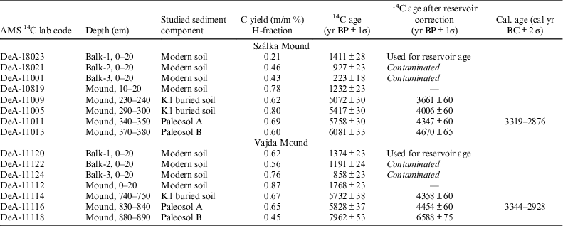
14C ages and calibration results of charred organic fraction of the soil samples collected at the studied kurgans.
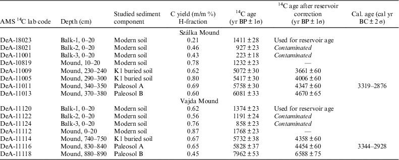
Under the compiled soil layers the A layer of the buried former natural soil was identified (paleosol A, 340–370 cm). This is a dark brown (10YR 3/1) homogeneous soil layer that is followed by a B layer with increasing lime content (paleosol B, 370–400 cm). The upper level of this chernozem-like paleosol has an age of 5758±30 BP. In order to determine the accurate age of the construction of the mound this paleosol age was corrected by the reservoir age of the recent soils. Since the radiocarbon ages of the three recent topsoil samples from the surroundings of the mound showed great standard deviation these were not averaged to determine the soil reservoir age but the 14C age of the oldest, probably least disturbed sample was taken as the soil reservoir age (1411±28 BP). Following this correction, the buried paleosol A layer showed an age of 4347±30 BP equalling the age of cal BP 4826–5269 (2σ). Probably the mound was built in this period, i.e. the natural soil once on the surface was buried by the material of the mound. The buried soil gradually transforms into the late Pleistocene light yellowish brown (2,5Y 6/4) infusion loess with higher clay content. This bedrock has much lower organic matter (<1%), higher lime (>20%) content and gradually decreasing magnetic susceptibility (k=30–10) compared to the material of the mound.
On the basis of the specific resistance values of geo-electric profiling it seems like the mound had a natural convex core, the highest crest line of the river levee (7–13 Ωm resistivity). This means that the mound was not built initially on a completely flat surface. The lower (1–5 Ωm) and higher (20–50 Ωm) resistivity layers of the two building phases can be separated clearly in the body of the mound. Several smaller anomalies with 2–2.5 m in diameter can be identified in the compiled material of the mound and also in the buried soil layer mostly in the southern side of the mound. Apart from these, greater anomalies of 5–10 m can be detected in the inside of the mound in every direction.
Vajda Mound (Hajdúság)
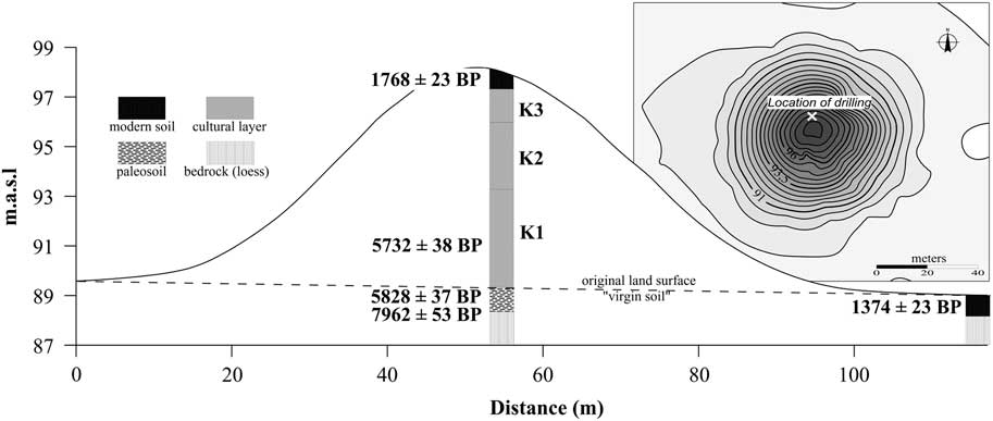
Rising from the loess plateau at the western margin of Hajdúság, the Vajda Mound belongs to one of the larger mounds in Hungary. The 8.2-m-high mound with a ground area of 4696 m2 was built from 12,114 m3 of compiled soil. The 9.5-m-deep borehole exposed eight soil layers from the top of the mound (Figure 3).
Contour map of the Vajda Mound and the results of the stratigraphic analyses. (Image designed by C Tóth.)
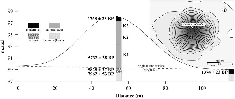
The top of the mound is covered by black (10YR 2/1, 10YR 2/3) modern soil with a crumb structure (modern soil A layer: 0–40 cm; B layer: 40–80 cm) typical of chernozem (animal burrows, lime dynamics, crumb structure). The 14C age of the recent soil is 1768±23 BP. There are probably three anthropogenic compiled layers under the modern soil until the start of the buried paleosol (830 cm) that are clayey silt with minimal sand content (Table 1). The K3 cultural layer (80–220 cm) is a dark brown (10YR 2/3) slightly compacted layer with 2.7–3.3% humus and 3.5–9.2% lime content and with some lime concretions. The K2 cultural layer (220–500 cm) is a dark grey-black (10YR 3/2) strongly compacted compiled layer with conchoidal fracture, humus content (2.3–3.5%) similar to the previous layer while its lime content is smaller (3.5–6.4%). The K1 cultural layer (500–830 cm) is darker than the previous ones, it is black (10 YR 2/1), its humus content reaches 2.2–4% while its lime content is higher than that of the K2 layer (4–9.1%) and it becomes gradually wetter downwards. The medium and high humus contents of the three compiled cultural layers (>2%) indicate that the mound was built of the humus containing topsoil layers of the surrounding areas. The radiocarbon age of the sample from the K1 layer (740–750 cm) is 5732±38 yr BP and is similar to the Szálka Mound and is significantly older than the modern soil on the top of the mound.
The crumb-structured, black-dark brown (10YR 2/1) paleosol (830–910 cm) has a leached A layer and a B layer showing lime accumulation the decreasing humus content of which represents a transition to the yellowish (10YR 5/4) loess bedrock. The 14C age of the paleosol A is 5828±37 BP that is almost the same as the age of the soil sample from the K1 layer (Table 2). This shows that the recent topsoil of the surrounding areas was the first building material of the mound. The age of the oldest sample out of the modern soil samples from the surroundings of the Vajda Mound is regarded as the reservoir age of the soil as well (1374±23 BP). Extracting the reservoir age from the 14C age of the paleosol A, the time (4454±60 BP) of the first building phase of the Vajda Mound can be obtained. These correspond to cal BP 4878−5294 (2σ) age indicating a building period similar to that of the Szálka Mound.
Geo-electric profiles indicate that Vajda Mound was also built on a slightly convex river levee similar to Szálka Mound. The humus-containing, slightly wet topsoil of the first building phase with low specific resistivity (7–11 Ωm) and high clay content can be clearly separated from the somewhat lower resistivity (3–7 Ωm) soil layer of the second building phase. The material of the third building phase could be clearly separated from the lower layers with its significantly higher resistivity (11–95 Ωm) and marked disturbed structure. In this layer several 2.5–3-m-wide, angular anomalies could be detected. Highest resistivity values were yielded by the modern soil full of animal burrows and desiccating in the summer heat with values between 150 and 350 Ωm on the southern slopes of the mound.
DISCUSSION
Szálka and Vajda Mounds belong to the middle-sized and the large kurgans, respectively, in Hungary. Vajda Mound is twice as high and has four times greater volume than that of Szálka Mound, but still does not reach the size of the largest Copper-Age kurgan in Hungary (Gödény Mound in Békés County, 11.5 m high). The studied mounds resemble the Copper Age (4500–2800 BC) kurgans of the Great Hungarian Plain and the Eurasian steppe regarding their size and shape (Horváth Reference Horváth2011; Dani and Horváth Reference Dani and Horváth2012; Deák et al. Reference Deák, Tóthmérész, Valkó, Sudnik-Wójcikowska, Moysiyenko, Bragina, Apostolova, Dembicz, Bykov and Török2016).
On the surface of the studied mounds, chernozem-like recent soils were formed on an old, compiled soil layer with high humus content. Modern soils are all younger (Szálka M: 1232±23; Vajda M: 1768±23) than the buried paleosols since they are part of the organic carbon circle in contrast to buried soils that are excluded from it (Molnár and Svingor Reference Molnár and Svingor2011). A similar modern age (1200±50 BP) was measured on the surface of Csípő Mound at Hortobágy by Molnár et al. (Reference Molnár, Joó, Barczi, Szántó, Futó, Palcsu and Rinyu2004). The modern soil of the Szálka Mound was measured to be more than 500 yr younger than that of Vajda Mound. This can be explained by that the top of Szálka Mound was disturbed when the border ditch and the triangulation point were created while no signs of such disturbance could be identified in the case of Vajda Mound.
On the basis of pedological and geo-electric analyses, probably two and three cultural layers could be identified in the inside of the lower Szálka and the higher Vajda Mounds, respectively. This corresponds well with earlier geoarchaeological results in Hungary according to which the smallest Pincés Mound (2.5 m) contains only one, the middle-sized Kántor (4.0 m) and Ecse (5.5 m) mounds contain two while the Csípő, Lyukas, Bán and Fekete Mounds higher than 6 m contain three or four cultural layers (Barczi et al. Reference Barczi, Joó, Pető and Bucsi2006, Reference Barczi, Golyeva and Pető2007; Bede et al. Reference Bede, Csathó, Czukor and Sümegi2015; Barczi Reference Barczi2016; Pető et al. Reference Pető, Baklanov, Tóth, Tóth and Barczi2016). It can be stated that the Szálka Mound was originally built by the Yamnaya Culture but at that time it was only 1.7 m high with a diameter of 30 m. It reached its current height of 3.7 m during a subsequent construction phase. The Vajda Mound was also built by the Yamnaya Culture to a height of 3.3 m. Subsequently, two additional elevation phases are assumed. During these phases, the kurgan reached its height of 6.1 m and later its current height (8.2 m). The soils of the individual construction phases differed in color, structure, humus, and lime content. Since archaeological finds were not included, the age determination of construction phases were determined from radiocarbon measurements. The complexity of the inner structure of the kurgans is not dependent on their age, but on the length of time that they have been used for funeral purposes for several centuries, i.e. how many times the kurgan was increased in elevation at later times.
The geophysical investigation of kurgans is not yet widespread. In Hungary, only magnetic anomaly measurements using a magnetometer have been applied and the near surface disturbance (ditches, burials) could be identified in the case of Nagycsősz and Bosnyák Mounds at Polgár and Zsolca Mound at Felsőzsolca (Raczky et al. Reference Raczky, Czajlik, Marton, Holl and Puszta1997; Puszta Reference Puszta1998; Tóth et al. Reference Tóth, Pethe and Hatházi2014). With geo-electric measurements based on the specific resistance values dependent on the grain size and moisture content of the sediments, however, stratigraphic information can be obtained from greater depths as well exposing the inner structure of the entire mound. The stratification yielded by the measured specific resistance values were in agreement with the pedological and stratigraphic observations. The method was suitable to map disturbances (burials) detected in both the buried soil layers and the inside of the mound. Small anomalies detected on the southern side of Szálka Mound can be the traces of graves, buried objects or smaller later disturbances. Larger anomalies, however, could be of natural origin or changes in the quality or compactness of the building material. The patch-like anomalies 2–3 m in diameter in the central part of Vajda Mound in the K3 cultural layer could be the traces of later burials or other disturbances made by people or animals. Patch-like anomalies at the foot of the mound may indicate the disturbed places of pit holes. It is highly likely that the studied mounds were disturbed and there were several burials after the first burials.
Extracting the radiocarbon ages of modern soils from those of the buried soils (soil reservoir age) the time of building the mounds can be obtained accurately (Molnár and Svingor Reference Molnár and Svingor2011). Radiocarbon ages of modern soil samples taken from the surroundings of Szálka and Vajda Mounds shows high standard deviation suggesting that at some of the randomly placed, seemingly undisturbed sampling sites subsequent anthropogenic disturbance resulted in younger soil ages. As a result, the oldest modern soil ages (1411±28 BP and 1374±23 BP) were regarded the soil reservoir age. Somewhat older soil reservoir ages were previously determined in the cases of Lyukas (2010±80 BP) and Csípő (2210±80 BP) Mounds that, however, are located relatively distant from the mounds studied here (Molnár et al. Reference Molnár, Joó, Barczi, Szántó, Futó, Palcsu and Rinyu2004; Molnár and Svingor Reference Molnár and Svingor2011). These differences between the soil reservoir ages can be explained by differences in the geological conditions (base rock), climate (mainly precipitation), and vegetation type (Wang et al. Reference Wang, Amundson and Trumbore1996).
The ages of 3319–2876 cal BC (2σ) and 3344–2928 cal BC (2σ) obtained after reservoir correction and calibration of the paleosol of Szálka and Vajda Mounds indicate that the two mounds could be burial mounds or kurgans built by the Yamnaya Culture in almost the same time period at the end of the Copper Age. The Szálka and Vajda Mounds were also constructed during the Early Yamnaya Culture, Period II: Pre-Pit–Grave horizon, which is the primary phase of the multi-depository kurgans, such as the Hungarian Hajdúnánás-Tedej–Lyukas Mound and Sárrétudvari–Őr Mound (3400/3300–3000/2900 cal BC) (Horváth Reference Horváth2011). This period in the steppe areas was contemporary with the Late Repin, Late Konstantinovka, Novosvobodnaja, Late Kvityana, Late Dereivka, Boleráz, and Cernavodă III–Classic Baden Cultures (Rassamakin Reference Rassamakin1999, Horváth Reference Horváth2011). People of the nomadic Yamnaya Culture built several thousand kurgans from what is today southern Russia (between the Ural and Volga Rivers) to the Carpathian Basin (along River Danube) at the end of the Copper Age and the beginning of the Bronze Age (3500–2200 BC) (Ecsedy Reference Ecsedy1979; Morgunova and Khokhlova Reference Morgunova and Khokhlova2013). The inner structure of Szálka and Vajda Mounds exposed by boreholes and geophysical analyses agrees with the structure of archaeologically excavated kurgans built by the people of the Yamnaya Culture in Hungary. This culture built mounds of various heights from the upper, humus-rich layers of the surrounding soils after their initial burial activity in either one or several phases for the noble people. In the Great Hungarian Plain the younger building period for the multi-phased kurgans can be linked to the Yamnaya Culture Period III: Early-Pit–Grave horizon, moreover, the wood-constructed burials with no or poor grave deposits. This horizon can be associated with the end of the Late Copper Age–Early Bronze Age transitional period, including the Late Classic surviving Baden/Coţofen IIIa,b Culture. This period can be dated between 3100 and 2700 cal BC, wich overlapped Period II (Horváth Reference Horváth2011). The latest, third construcion phase of the kurgans was in the Early Bronze Age, that is the Yamnaya Culture Period IV: Late-Pit–Grave horizon, contemporary with the Catacomb entity. This horizon includes the surviving Baden, the Vučedol, the Makó, the Early Somogyvár-Vinkovci and the Coţofen IIIc Cultures, and dated to 2900/2800–2500/2400 cal BC (Horváth Reference Horváth2011). The latter layers might have been used as burial places by later possible cultures as the Scythians (800–500 BC), Sarmatians (100–400 AD), Hungarians (900 AD–Medieval) and Cumans (1200 AD–Medieval) as well. Specific anomalies detected by geophysical investigations could even indicate the subsequent burials of these ethnic groups. During the archaeological exploration of the late Copper Age Árkos Mound near to the town of Hajdúszoboszló (30 km away from the Vajda Mound), several Hungarian tombs of the Hungarian conquest period were identified in the top layers of the kurgan (Dani and Horváth Reference Dani and Horváth2012).
SUMMARY AND CONCLUSIONS
Since archaeological excavation was not possible and archaeological findings were not available, the age of the building of the studied mounds was determined based on the radiocarbon age of the buried soils while the method of building was identified using stratigraphic analyses and geo-electric measurements. These measurements can be made on the protected structures with little surface disturbance.
Radiocarbon ages of the buried soils of the studied mounds located near each other are very similar while the radiocarbon ages of the modern soils in the surroundings of the mounds have high standard deviation. As a result, the oldest modern soil age was considered that represents the age of the least disturbed natural soils. Correcting the radiocarbon ages of the buried soils gives an accurate time of mound building. The building ages of 3319–2876 cal BC (2σ) and 3344–2928 cal BC (2σ) obtained after calibration show that the Szálka and Vajda Mounds are burial mounds built in the same time period by the Early Yamnaya Culture 2nd period at the end of the Copper Age (Pre-Pit-Grave horizon). Both kurgans could be further elevated in the 3rd period of the Yamnaya Culture (Early-Pit-Grave horizon), which took place in the transitional period of the Late Copper Age and the Early Bronze Age, when a cultural shift happened in the Great Hungarian Plain. In the case of the Vajda Mound, a third elevation might have occurred in the Early Bronze Age (Yamnaya Cultura 4th period Late-Pit-Grave horizon). On the basis of pedological and stratigraphic analyses, the lower Szálka Mound was probably built in two phases, whereas the higher Vajda Mound was constructed in three phases, from the humus-containing local topsoil. The loess base rock of the mounds was not used for the building of the kurgans or in very small amount, so pit holes were probably shallow that became almost completely filled by today. The geo-electric analyses corresponded well with the results of stratigraphic analyses. The anomalies of specific resistance indicated clearly the traces of disturbance (burial, subsequent digging) within the mounds and in their foregrounds. We can conclude that geo-electric analysis can be strongly recommended for the geoarchaeological study of kurgans.
ACKNOWLEDGMENTS
The research was supported by the European Union and the State of Hungary, co-financed by the European Regional Development Fund in the project of GINOP-2.3.2-15-2016-00009 “ICER”.