Introduction
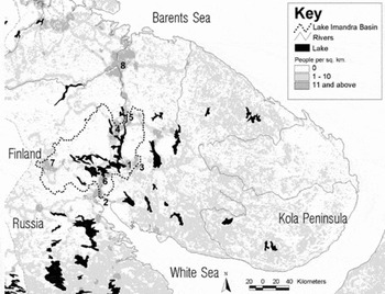
This paper presents the results of a five year study of preindustrial land and water use in the Lake Imandra watershed on the western Kola Peninsula of the Russian Federation (Fig. 1). Russian and American researchers interviewed former members of reindeer herding villages [in Russian pogosty, singular pogost] and analysed archival materials including maps and photographs to reconstruct how Saami families utilised land and water in the region for hunting, fishing, and other economic activities prior to World War II. The overlapping, multi-source database facilitated GIS mapping that documented the locations of these traditional resource territories. Informants also helped produce genealogies illustrating how Saami reindeer herding family members interacted through exploiting and inheriting resource territories.
Map of the Kola Peninsula including the Lake Imandra watershed, major cities, and population densities. The concentration of population centres mainly along the former Kola Track [Trakt] shows the influence of the railway, modern highway system, and industrial facilities on the development of the Lake Imandra region. Cities are 1) Apatity, 2) Kandalaksha, 3) Kirovsk, 4) Monchegorsk, 5) Olenegorsk, 6) Polyarne Zori, 7) Kovdor, and 8) Murmansk. Map courtesy of Lars Bromley, American Association for the Advancement of Science.

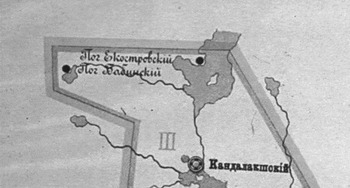
Pogosty was an archaic Russian word meaning traditional Kola Saami villages (Lukianchenko Reference Lukianchenko and Broadbent1989), but which applied to no other northern indigenous group. Although mentioned in historical documents and ethnographies from the late 19th century, pogosty had a very limited regional meaning except for its classical use in the Russian Orthodox context (I. Krupnik, personal communication, 18 March 2008). In the late 19th century all of the approximately 1,800 Saami living on the Kola Peninsula (Heinapuu no date) were members of the Russian Orthodox Church. Western Saami pogosty were part of Kola Lapp parish in the Kola district of Archangel province, which was further divided into three cantons, each containing several pogosty. Babinski and Ekostrovski pogosty constituted the Ekostrovski canton of Kola Lapp parish (Fig. 2).
A Russian Orthodox Church map, 1890. At the top are Ekostrovski and Babinski pogosty, which together formed the Ekostrovski canton of Kola Lapp parish. The parish seat at Kandalaksha is also shown, along with a parish school to the south. Courtesy of Helsinki University.

Saami pogosty may have been remnants of indigenous reindeer herding communities called siida found throughout Sápmi (the Saami homeland) (Konstantinov Reference Konstantinov1997: 17; Meriot Reference Meriot1984: 379; Robinson and Kassam Reference Robinson and Kassam1998). Despite being changed through centuries of interaction with Russian and Scandinavian groups in the region, Kola Saami pogosty were kinship based communities or obshchina (Konstantinov Reference Konstantinov2005: 170) that exploited common pasturage and owned fishing and hunting territories within extended families (Encyclopaedia of Saami Culture 2004; Manker Reference Manker1953: 13–17; Pehrson Reference Pehrson1957: 92–93). Pogosty maintained permanent summer and winter settlements, along with several temporary spring and autumn camps close to their resource territories. Besides having common socioeconomic interests, pogosty participated in shared pre-Christian spiritual life and beliefs through worship sites such as seids (sacred stone designs) and cemeteries.
Three Saami pogosty inhabited the Lake Imandra watershed before World War II; Babinski [in Saami Akkel] in the south, Ekostrovski [in Saami Cukksual] in the centre, and Masel [in Saami Maaziellk] in the north (Y.Y. Patsiya, personal communication, 10 July 2002; Took Reference Took2003). Despite various attempts through the years to depict pogosty boundaries (for example Sergejeva Reference Sergejeva2000; Nickul 1970), primary sources do not provide sufficient detailed information to confirm these depictions. None of these previous maps are presented here in order to prevent the perpetuation of their use as authentic sources. One of the goals for the development of the mapping component of the present project was to determine whether a boundary could be drawn between Babinski and Ekostrovski pogosty using traditional resource territories owned by their respective members.
To conduct the study, the authors concentrated on Babinski and Ekostrovski pogosty. The two pogosty formed a cohesive socioeconomic and cultural unit, speaking a common Saami dialect called Akkala, and having similar housing styles and economies that differentiated them from their neighbours. Due to several factors, such as living in geographical proximity and speaking the same dialect, Babinski and Ekostrovski pogosty members sought mates in each others’ villages (Polla and Kuropjatnik Reference Polla, Kuropjatnik, Hämynen, Partanen and Shikalov2004). In fact, Babinski and Ekostrovski pogosty were so integrated along socioeconomic lines that they shared a ‘common land for two siddas’ relationship, referred to by neighboring Skolt Saami as a kueitmeerjannam (Sergejeva Reference Sergejeva2000: 11).
During the period from 1890 to 1910 Babinski and Ekostrovski pogosty maintained relatively stable populations, ranging from between 68 to 108 in the former and from between 63 to 72 in the latter (Polla and Kuropjatnik Reference Polla, Kuropjatnik, Hämynen, Partanen and Shikalov2004: 245, Table 1). Pogosty residents were organised in multi-generational households at the turn of the 19th century. Most households in Babinski and Ekostrovski numbered fewer than ten persons, ranging between seven and 20, with a norm of between six and eight persons. The basic family unit was a married couple, and few single person or non-related residential households existed in the villages. While the majority of households contained one or more extended families living together in the winter settlements, households were in a constant state of flux. Multi-generational households were often temporary, consisting at various stages of the grandparents, one or more married sons and their wives, and grandchildren. By custom, the oldest married son would leave the house to start his own family, while one married son stayed behind to help the parents with their subsistence (Kharuzin Reference Kharuzin1890). Complex households were probably necessary due to the difficult lifestyle of reindeer herding in the region. According to Polla and Kuropjatnik, ‘the custom of living in large, complex households during the winter may be seen as a means of providing security for women, children and old people at a season of the year when the menfolk were often away for long periods hunting or transporting goods by reindeer sleigh’ (Polla and Kuropjatnik Reference Polla, Kuropjatnik, Hämynen, Partanen and Shikalov2004: 255).
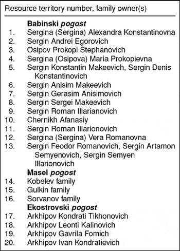
List of resource territories and their Owners

Traditional western Kola pogosty practiced mixed economies. Unlike eastern Kola villages, Saami living in the Lake Imandra watershed did not herd reindeer as their primary occupation (Lukianchenko Reference Lukianchenko and Broadbent1989). Although the economy changed during the second decade of the 20th century due to Soviet influences to make the families became less nomadic and to increase the size of their herds for commercial meat production, herders in the Lake Imandra watershed used their herds primarily for commercial transport. Usually, Babinski and Ekostrovski pogosty families had small herds of fewer than ten animals. Toward the end of the 19th century Babinski pogost families owned a total of 114 reindeer, while Ekostrovski families had a total of 318 animals (Dergachev Reference Dergachev1877: 14). In summer, after calving, reindeer were released for free range grazing, in a system called ‘half-free’ herding (Lukianchenko Reference Lukianchenko and Broadbent1989: 91; Kharuzin Reference Kharuzin1890). The specific type of reindeer herding practiced by the western Kola Saami permitted other seasonal economic activities, including commercial transport and fishing.
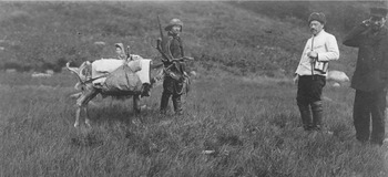
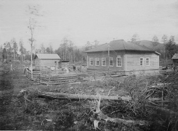
For centuries, moving people and goods along the former Kola Track [in Russian Trakt] that ran from Kandalaksha on the White Sea up the Niva River to the Arctic Ocean port of Kola was an important source of income for Babinski and Ekostrovski families (Dergachev Reference Dergachev1877: 61). Saami herders moved freight and passengers with boats on rivers or lakes and overland by draft reindeer in summer, and by reindeer sledge in winter (Fig. 3). Toward the end of the nineteenth century, Russia surveyed Lake Imandra's eastern shore to lay a telegraph cable. Post and telegraph stations sprang up along the route at distances of between 20 to 33 miles, which began attracting Saami families who settled near the stations to provide commercial transport (Fig. 4). By the revolution some Ekostrovski pogost families had moved to the eastern shore and created a settlement called Polvinka to take advantage of economic opportunities at Imandra Station, the newly completed railway stop on the line between Kandalaksha and Kola.
‘Nikandr Semenitsh Briskin [Russian telegraph operator] leaves for a tour of inspection. His loaded reindeer is waiting for him. A Lapp woman from Jokanga village stands behind the reindeer, 1914.’ Photo by T.I. Itkonen, National Museum of Finland.

‘A telegraf [sic] station. Bjälaga Guba, Imandra [Lake], Kola Peninsula, 1880s(?).’ Photo by Wilhelm Ramsey, National Museum of Finland.

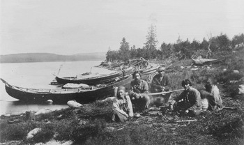
Despite being referred to as reindeer herders, Babinski and Ekostrovski Pogosty families earned much of their incomes from inland fishing, the products of which they sold in Russian villages like Kandalaksha and Kola (Alymov Reference Alymov1927). While much of the income for Kola Saami living along the northern and southern coasts came from salmon fishing on the Arctic Ocean and White Sea, the importance of inland fishing for interior Saami families was shown by the several fishing places they controlled along lakes, bays, and rivers (Fig. 5). For example, in 1877 Ekostrovski pogost owned only one coastal salmon fishing territory out of a total of 121 on Kola, while its families controlled approximately 90 of 172 inland fishing grounds in the Lake Imandra watershed. Important inland fish were herring, trout, char, grayling, pike, perch and burbot. In addition to selling some of the catch, much of the fish, especially pike and perch, was dried for their own winter food (Dergachev Reference Dergachev1877; Hallström Reference Hallström1911; Volkov Reference Volkov1996).
‘Resting. Kola Peninsula, Imandra, 1867.’ Photo by J.A. Friis, National Museum of Finland.

To obtain subsistence and income, prior to World War II Saami reindeer herding families ‘owned’ resource territories to graze, hunt, fish and cut timber. As in other parts of Sápmi, the term ‘ownership’ might not be appropriate in strictly legal terms, but pogosty councils assigned resource territories to individual households for so long that they were considered private property (Polla and Kuropjatnik Reference Polla, Kuropjatnik, Hämynen, Partanen and Shikalov2004). Resource territories were divided into two parts, one for use by the family and one kept in reserve to be inherited by the eldest son (Volkov Reference Volkov1996; Lukjancenko Reference Lukianchenko1983; Took Reference Took2003). Babinski pogost families controlled many of the lands and waters on the southwestern side of the Lake Imandra watershed well into the Soviet period (Wheelersburg and Gutsol Reference Wheelersburg and Gutsol2008). Similarly, the resource territories of Ekostrovski pogost families were situated west of the lake in and around the modern industrial city of Monchegorsk.
Eventually, development in the region eliminated western Kola reindeer herding villages. Families began supplementing their household incomes with cash labour in agriculture or lumbering, and/or in service industries. Household economies remained mixed until the Soviets began collectivising reindeer herding in the 1920s as part of their overall modernisation programmes on the Kola Peninsula. Babinski and Ekostrovski pogosty families continued hunting and fishing in the region for decades after World War II, but they slowly integrated into the Russian economy by working in the Kola industrial complex. Some of the former herding families settled permanently in the mixed ethnicity village of Yena, and the modern industrial cities of Monchegorsk and Apatity (Polla and Kuropjatnik Reference Polla, Kuropjatnik, Hämynen, Partanen and Shikalov2004).
Theoretical orientation
This study of pre mechanised Saami reindeer herding pogosty prior to Soviet collectivisation and relocation programmes before World War II addresses an important question about cultural change in the Russian part of Sápmi. This is did Kola Saami pogosty represent continuity with earlier, perhaps indigenous Saami herding communities like the sidda? Some scholars assert traditional Saami culture continued into the 20th century despite Sápmi being incorporated into the states of Norway, Sweden, Finland and Russia (Sarv Reference Sarv, Seurujärvi-Kari and Kulonen1996: 132). While some believe that Saami culture changed significantly in the Scandinavian states (for example Lehtola Reference Lehtola2002; Kvist and Wheelersburg Reference Kvist and Wheelersburg1997), an important aspect of the cultural continuity view is that despite a millennium of interaction with Russians, the Kola Saami ‘remained the longest close to the original culture of any Saami group’ (Meriot Reference Meriot1984: 381).
Kola Saami cultural continuity may derive from the region having no fixed borders limiting the influences there to those of a single state (Sergejeva Reference Sergejeva2000). Prior to World War II the Kola Peninsula was unlike other parts of Sápmi where sovereignty programmes eliminated Saami language and other traditional behaviours (Lehtola Reference Lehtola2002). The openness of the western Kola Peninsula to invading and invited armies alike, especially during the first half of the 20th century, contrasted sharply with Norway, Sweden, and Finland. For example, perhaps at no other location in Russia was the 1917 revolution threatened more than on Kola, where the multinational, but British inspired ‘Interventionists’ hoped to put a quick end to the fledgling Red Army. Following the 1920 surrender of the White Army in Murmansk, the Soviets finally controlled the Kola Peninsula (Took Reference Took2003). Yet, the region remained open to other nations’ armies during both the Winter War with Finland, and during the early years of World War II. The Russian border with Norway and Finland, although firmly established was not absolute until after annexation of the former Finnish region of Petsamo by the peace treaty of 1947.
Perhaps due to their lack of control over the region, both the Tsarist and the Soviet governments permitted some Saami political and economic autonomy. For example, the Soviets allowed private reindeer ownership for a time even after implementing the collective farm [kolkhoz] (Konstantinov Reference Konstantinov2005: 181). Perhaps due to Russian permissiveness, some scholars assert that traditional elements of the Kola Saami pogost continued in the Soviet reindeer brigade [in Russian brigad] since both were ‘minimal reindeer-herding collective[s]’ (Konstantinov Reference Konstantinov2000: 52). The brigade is a subunit of the kolkhoz, and each collective farm containing several brigades, each utilising some ten herders to tend between 4,000 and 6,000 reindeer. Chumrabotnik (Russian) or paid females cook, clean, and do laundry for the herders, and the brigade has its own veterinary team. While some brigades may be exclusively Saami, many if not most are multi-ethnic (Beach Reference Beach and Kvist1992: 119). In some brigades relatives may herd reindeer together, but family connections are not a requirement for membership.
The Russian government implementing rational herding policies suggested that a brigade should consist of six herders tending from between 1,800 to 2,200 animals (Konstantinov Reference Konstantinov1997: 16), although the numbers of herders and animals continue to vary between brigades. Mechanisation reduced the number of women and children participating in herding. Centralisation separates the male herders from the remainder of the family, which is no longer nomadic but stays in permanent villages such as Lovozero. Brigade members support their families and other dependents in the villages, such as pensioners or the unemployed. To some scholars, despite the differences in ethnicity, gender roles, and family involvement in herding, each brigade forms a minimum herding collective, and several brigades together equate to a cluster of pogosty from the earlier period (Konstantinov Reference Konstantinov2000).
To some, continuity between the pogost and the brigade despite these differences is evidence of the necessity of the minimal herding collective in the Arctic. The minimal herding collective transcended culture because it had an optimal ratio of one herder to between 300 and 450 reindeer (Konakov Reference Konakov1993: 100; Konstantinov Reference Konstantinov1997: 16). Additional evidence for Saami cultural continuity included the overlapping pogost and brigade grazing territories and the use of similar locations for both settlements. Thus, the minimal herding collective was a predetermined socioeconomic structure representing
a line of continuity connect[ing] the pre-collective pogost [siida] with the first collectives – artel’ and kolkhaz – and, eventually, with sovkhoz [Soviet state farm] and post-sovkhoz brigades. . .This rests on the premise that to herd reindeer one has to have a minimal group – be it an extended family, a cluster of such families (siida, pogost), or a brigade. In this sense the reindeer-herding sovkhoz can be seen as a still bigger cluster of minimal collectives who have not changed in important structural characteristics from previous historical variants (Konstantinov Reference Konstantinov2000: 50, 53).
The cultural continuity view derives from theoretical models asserting that the evolution of particular socioeconomic structures and their relationship to a primary herd animal, led to the development of Arctic reindeer pastoralism (Ingold Reference Ingold1980: 3–5, 112–116; Beach Reference Beach, Galaty and Douglas1990: 261). To manage reindeer herds effectively in the Arctic, the minimal herding unit developed over time as the necessary socioeconomic structure. If the minimal herding unit was required throughout Sápmi, then Kola Saami pogosty were more influenced by the internal socioeconomic response of adopting a northern pastoralist economy than by the external influences of state level societies.
In contrast to the cultural continuity view, scholars advocating cultural discontinuity claim that virtually all of traditional Saami culture was changed through the external influences of state level societies (Eidlitz Kuoljok Reference Eidlitz Kuoljok1987: 74; Lehtola Reference Lehtola2002: 68). Saami cultural discontinuity may have occurred as early as the 16th century in Scandinavia when Swedish administrators created a European style socioeconomic organisation called the sameby [in Swedish Saami village] that replaced the indigenous sidda (Kvist and Wheelersburg Reference Kvist and Wheelersburg1997: 1). While the Kola Peninsula did not come under state control as early as other portions of Sápmi, many believe cultural discontinuity applied especially to the Russian Saami. In contrast to the assumption by many scholars that it existed in ‘relative isolation. . .with a wide berth of autonomy’ (Eidlitz Kuoljok Reference Eidlitz Kuoljok1987: 74), others concluded that the Tsarist administration and the Russian Orthodox Church, changed traditional Kola Saami society (for example Lehtola Reference Lehtola2002), which was further altered by later Soviet programmes.
Even if some traditional elements survived earlier periods, the cultural discontinuity view asserts that Sápmi changed rapidly in first half of the 20th century. For example, ‘Norwegianization’ transformed many Saami into settled, Christian farmers fluent in majority society language and culture (Lehtola Reference Lehtola2002: 44). In Finland, Skolt Saami lost traditional culture as a result of rebuilding the region destroyed during World War II, including accepting modern transportation technology during the so-called ‘snowmobile revolution’ (Pelto Reference Pelto1987). Yet, to some, nowhere did the attempt to eliminate Saami ethnicity succeed as on the Kola Peninsula, where ‘[t]he fate of the Kola Saami in the 1900s is the most tragic of all [. . .as the] traditional siida system collapsed in the decades after the Russian Revolution in 1917’ (Lehtola Reference Lehtola2002: 68–69). In the late 1930s, the Soviets created reindeer herding collectives, repressed (that is arrested and/or executed) those Saami leaders who resisted, and in the 1950s and 1960s moved Saami villages to central locations. Combined with earlier mixing of Kola Saami communities with immigrant ethnic groups like the Komi in the late 19th century (Hallström Reference Hallström1911: 241; Konstantinov Reference Konstantinov1997: 15; Sarv Reference Sarv, Seurujärvi-Kari and Kulonen1996: 132), the Soviet programme ultimately disconnected the reindeer brigade from the traditional pogost.
Following the cultural discontinuity view, the modern reindeer brigade developed through state level control and it has no connection to the traditional pogost, let alone the indigenous siida (Kiselyeva Reference Kiselyeva1984: 85; Gutsol and Riabova Reference Gutsol, Riabova, Karppi and Eriksson2002: 317). Since the reindeer brigade was imposed on the Saami by the Soviets, the Saami merely replaced one type of herding structure with another. Instead of requiring a minimal herding collective, reindeer herding was possible through a variety of socioeconomic forms, with regulatory differences in the various states being responsible for the particular herding structures that developed within specific countries. These structures included the Russian brigad, the Swedish sameby, the Norwegian reindriftsdistrikt [reindeer husbandry district], and the Finnish paliskunta [reindeer herders association]. Other differences included laws in Sweden and Norway that allowed only ethnic Saami to graze reindeer on communal lands (although non-Saami such as northern Swedish farmers may own them), while in Finland and Russia non-Saami can own and tend reindeer.
Methodology
In the pilot phase of the present project, personnel surveyed archival materials and visited local organisations to determine whether traditional knowledge existed on pre-industrial territories and resource use in the Lake Imandra watershed. Specifically, the authors, with research assistant Anastasia Eremeeva travelled to western Kola to meet representatives of the Saami Cultural Centre in Lovozero, the Kovdor department of the Kola Saami Association, and the Local History and Economy Museum of Monchegorsk. The preliminary survey revealed that survivors and descendants from Babinski and Ekostrovski pogosty held significant traditional knowledge that could be obtained through informant interviews and family records. Additionally, primary source documents were studied in Helsinki at the National Library and the National Board of Antiquities, both of which contained much information on the pre-World War II pogosty.
Over the next two summers, informant interviews and archival materials helped establish the locations of pre-World War II settlements and resource territories, along with the identification of their owners. The locations were recorded on 1:250,000 Russian or American maps of the region. This mapping differed from previous studies (for example Robinson and Kassam Reference Robinson and Kassam1998) because it documented resource territories instead of specific resource extraction locations. In some cases, the research team performed a limited field survey to ‘ground truth’ as many details as possible. For example, remains from the terminal Babinski pogost winter settlement were clearly visible as sod covered mounds during field surveys in 2004; however, the permanent Ekostrovski settlement had been replaced by industrial facilities and infrastructure. Informants also described subsistence and cash producing activities that supplemented reindeer herding and fishing, and they helped create family genealogies.
To produce a comprehensive overview of Saami traditional resource territories in the Lake Imandra watershed, the research team created a geographic information system (GIS) map recording their general locations. GIS technician M. Dodson obtained a base map covering the region from ‘ESRI World’ through the ESRI geography network using ESRI's ARCVIEW 9 software, ARCMAP version 9.3. Resource territory locations from the hand drawn maps were redrawn as polygons on the GIS base map, using natural terrain features like rivers and lakes and human made features such as railroad tracks and roads to aid in their placement. Comparing features on the GIS base map to those on the hand drawn maps confirmed that polygons approximated to the hand drawn locations, although the polygons provided general, not precise coordinates. The same process was used to produce other GIS layers that added contemporary cultural features including historic Russian and pogosty permanent settlements, cemeteries, the railroad and the Kola Track. Most of these cultural features were taken from historic maps (for example Temple Reference Temple and Rae1880). The final step in completing the GIS map was graphic design to add elements such as title, key, north arrow, scale bar, and citation.
Results
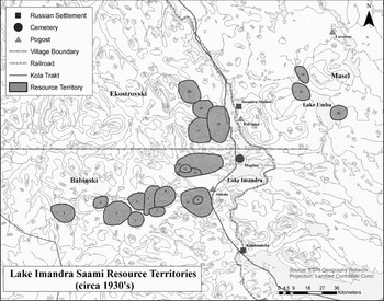
The GIS resource territory map is shown in Fig. 6, and the owners are listed in Table 1. Babinski pogost families were arbitrarily assigned numbers 1–13, Masel pogost families numbers 14–16, and Ekostrovski pogost families numbers 17–20. A hypothetical pogosty boundary line based upon the reconstructed resource territories is also indicated, which could refine previous attempts at demarcating the boundaries that did not use territorial ownship (for example Encyclopaedia of Saami Culture 2004; Took Reference Took2003).
Traditional Saami resource territories in the Lake Imandra watershed during the 1930s. Owners are listed in Table 1.

Pre-World War II Babinski fishing and hunting grounds were situated on Lakes Babinski, Chuna, Hirvas, Kalazhnoe, Komsa, Pirenga, and Rummel, along with the Chumba, Lyavaporog, Nyavka, and Pirenga rivers. Ekostrovski's families controlled territories on Lakes Kalozhonoe, Koshk, Kutskol, Lumbolka, Pivnus and Yurmporog, along with several land sites such as Lambina, Ostrovskoi, and Tuibolka. Ekostrovski pogost families also utilised Volodkin Island for fishing, hunting, and herding, and Mogilny Island [in Russian Island of the grave) in Lake Imandra near present day Apatity as a cemetery prior to road construction in the late 1930s.
Family relationships
By establishing resource territory locations and their owners, and combining that data with informant genealogies, the project team reconstructed pogost family relationships. A prominent Babinski pogost family name during the late 1930s was ‘Sergin’ (‘Sergina’ for females). One of the Sergin founders, Illarion (third name unknown) had three sons, Roman Illarionovich [in Russian ‘vich’ is ‘son of’]; (resource territory numbers 9 and 11), Prokopi Illarionovich, and Semyen Illarionovich (number 13). The pattern continued into a third generation with Roman's son, Feodor Romanovich (who also owned number 13) and daughter Vera Romanovna (number 12), along with Semyen's son Artamon Semyenovich (who also owned number13). The fourth generation included Vera Romanovna's nephew Sergin Andrei Egorovich (number 2).
Roman Illarionovich owned a large herd, which the family kept in winter on Kord Island and grazed freely in the summer on the Lapland preserve along Lake Rumeljavr. The family slaughtered reindeer mostly for subsistence at that time, although Roman Illarionovich earned cash before World War II by transporting goods to the Finnish Border with the family's reindeer. Family members hunted and fished their resource territories for subsistence and to obtain natural products to use in barter. They also preserved fish in wooden barrels buried in the swampy land, while they transported some of the fresh catch to Zasheek for barter. His son, Sergin Feodor Romanovich (number 13) owned reindeer mostly for transportation and his wife Sergina (Osipova) Maria Prokopievna (number 4) was the daughter of Osipov Prokopi Stepanovich (number 3). After his herds were seized by the government, Feodor Romanovich was drafted into the army and served in Norway transporting goods with reindeer, possibly participating in the Petsamo-Kirkenes campaign delivering supplies to forward combat units (Gebhardt Reference Gebhardt1990: 36). In 1948 he returned from military service and worked for eight years as the director of the collective farm in Yena, where his descendents live today.
Sergin Semyen Illarionovich owned a relatively large herd, probably for transportation services. His family maintained fishing ground on the isthmus between Lakes Chuna and Okht, near their calving place. His brother Chernyh Afanasi (number 10) owned resource territories on Lake Pirenga at Dlinnaya Guba (Long Bay) and at Avva Guba (Open Bay). Semyen Illarionovich was arrested and killed by the Soviets in 1937 for resisting relocation and collectivisation programmes. After his father's death, Sergin Artamon Semyenovich worked in the Lapland preserve, as well as transporting goods in the region. His daughter Sergina Olga Artamonovna married into the Arkhipov family from Ekostrovski pogost.
Although informants could not recall how it was related to the Illarion segment, Sergin Makee (third name unknown) founded another branch of the Sergin family. His three sons were Sergei Makeevich (number 8), Anisim Makeevich (number 6), and Konstantin Makeevich. The third generation stayed active in the mixed reindeer herding economy by owning hunting and fishing grounds. Anisim Makeevich's son was Gerasim Anisimovich (number 7), and Konstantin Makeevich had a son Denis Konstantinovich (number 5) and a daughter Alexandra Konstantinovna (number 1).
Osipov was another important Babinski pogost family name. Osipov Prokopi Stepanovich (number 3) was a private reindeer herder and fishermen on Lake Hirvas. In some sources Hirvas was described as a separate pogost with close contacts to Babinski (for example Storå Reference Storå1971; Itkonen Reference Itkonen1958). His father, Osipov Stephan (third name not known) had also lived on Lake Hirvas, leaving hunting and fishing grounds to his son on Lake Komsa. Prokopi Stepanovich was arrested in June 1938 and killed in November that year, as was his brother Nikolai Stepanovich. At least two other men in the Osipov family were arrested and killed in 1937 or 1938. Together, the Soviet repression of Babinski's leading herders in the Sergin and Osipov families severely reduced the ability of the pogost to function, and it ceased to exist by around 1940.
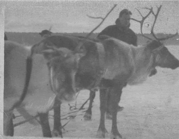
Informants were less successful in reconstructing Ekostrovski pogost family relationships, but there is sufficient information to create an illustrative example using the Arkhipov family. Arkhipov Kondrati Tikhonovich (Fig. 7; number 17) owned a large herd, which he used to transport goods. The family maintained pastures in the summer around Lake Inkas and in winter on Lake Lumbolka. Calving was at Tuibolka, between Lakes Koshk and Lumbolka, where they also hunted and fished. The family had its winter house at Lake Lumbolka, and in summer they moved to Lake Kutskol, where they preserved much of their catch in salted barrels and pits. They moved to Polvinka during the 1920s, but maintained a camping place on Ostrovskoe Lake until 1939 when Kondrati Tikhonovich was arrested and killed, and the family moved to present day Monchegorsk. Arkhipov Kondrati Tikhonovich had a son Ivan Kondratievich (number 20), who worked in the Lapland preserve as a hunter and goods transporter, supplementing his income by repairing boats and fish nets. A relative, Arkhipov Gavrila Fomich (number 19) had a wife named Maria Petrovna. Their daughter, Arkhipova (Arkhipov) Agafya Gavrilovna was born at Imandra Station, and worked as a housewife making money sewing national clothes, shoes, and fish nets, while other descendents worked in the Serveronickel processing plant in Monchegorsk.
Arkhipov Ivan Kondratevich from Ekostrovski pogost circa 1939. Unknown photographer.

The eastern part of the Monche Bay was used by another branch of the Arkhipov family, Danila Ivanovich Arkhipov and his son Feodor. Having a summer camp at Monche Bay they used the Nyuda River and Lake Nyuda as well as Lakes Chuno and Horn for fishing. Their herding territories were on the Pozuaivench, Nyuduaivench and Sopchuaivench fells. There was another member of the Arkhipov family, Leonti Kalinovich (number 18), although how he related to other Arkhipov family segments is unknown.
As stated above, Masel pogost was not a focus of the present study. Incidentally, informants confirmed that members of Mazel pogost used hunting and fishing grounds that bordered Babinski and Ekostrovski territories. The Kobelev family (number 14), the Gulkin family (number 15), and the Sorvanov family (number 16) owned resource territories on Lake Umba.
Discussion
The results indicated that Babinski and Ekostrovski families practiced mixed economies that consisted of reindeer herding, fishing, hunting and other activities from the late 1800s until at least two decades into the Soviet period. Extended families tended herds together, supplementing their incomes with cash labour such as working at the Lapland preserve or other government jobs, or through private transport services. These traditional economic activities were an important factor in maintaining the continuity of western Kola Saami reindeer herding pogosty families across generations. Pogosty families lived together in the same or neighbouring villages, with resource territories and marriage influencing settlement patterns. One of the critical factors in keeping families together across generations was inheriting and owning adjoining hunting and fishing grounds. At least twelve members of the Sergin family over three generations owned resource territories in Babinski pogost. The Arkipov family in Ekostrovski pogost also controlled many resource territories over several generations.
Pogosty often exchanged marriage partners and families (Kuropjatnik Reference Kuropjatnik1992), and the Sergin and Arkhipov families ultimately owned lands in both. That sort of dynamic was not surprising given the fact that pogosty were endogamous, with marriage sometimes taking place within the same family (for example Sergin), within pogosty (for example Sergin and Osipov), or between neighboring pogosty (for example Sergin and Arkhipov). Reconstructed family relationships revealed that Kola Saami pogosty were organised into herding groups similar to other parts of Sápmi. Typically, a herding group involved a father and two or three sons or sons-in-law. Two other families in Babinski had fathers and sons or sons-in-law combinations (assumed when a female spouse was listed as the resource territory owner), while the Arkhipov family showed a similar relationship in Ekostrovski pogost. Sometimes the father was deceased and three brothers formed the herding group, as in the case of Babinski pogost with the three sons of Sergin Illarion and with Sergin Makei's three sons.
Yet, do the results indicate that traditional elements of western Kola Saami culture, including economic activities, settlement patterns, and social structure, continued from the mid-19th century until World War II? First, it must be noted that this study cannot be generalised to the Kola Peninsula as a whole, because it is based on only two western Saami pogosty. Western and eastern Kola Saami pogosty differed by the number of their permanent settlements and the size of their migration routes. Eastern pogosty had two permanent settlements and long migration routes between pasturage in the interior forests and tundra on the coast. Western pogosty had one permanent settlement and several temporary residences, with smaller migratory routes between them and pasturage along the way (Kuropjatnik 2003: 102). Finally, unlike eastern Saami pogosty, all of the pogosty west of Lake Imandra were abandoned and the only reindeer herding conducted in all of western Kola is the reindeer farm Rassvet in the village Loparskaya (Saami Dawn). Babinski families were relocated to Yena. Although there were no special relocation programmes, Ekostrovski families just spread out along the railroad and Lake Imandra, and moved to Apatity, Monchegorsk, Olenegorsk. Consequently, there is no possibility of continuity from the pogost to the brigade for western Kola Saami.
There were also several demographic changes to Kola Saami pogosty that make generalisation inappropriate. For example, many Kola pogosty to the east of Lake Imandra were not exclusively Saami. Konstantinov (Reference Konstantinov2000: 49) described brigade based reindeer herding in Olenevod (Reindeer Herder) based in the village of Krasnoshchelye, which was founded in 1921 by Komi, not Saami, residents. It remains predominately Komi with smaller numbers of Saami, Nenet, Russian, and immigrants from other parts of the former Soviet Union also living there. Also, the number of Saami involved in reindeer herding decreased substantially after the 1930s as collectivisation proceeded (Konakov Reference Konakov1993: 100–101). Lastly, in the late 20th century reindeer herding became an almost exclusively male enterprise because of mechanisation (Konstantinov Reference Konstantinov2000: 53). Women and children were disconnected from herding to the point that they did not accompany the male herders on their migrations (Beach Reference Beach and Kvist1992: 122).
Due to advanced regional development and the influx of Russians and forced labourers from the Soviet Union, the Lake Imandra watershed contrasted significantly with the rather undeveloped and isolated eastern half of the peninsula. Unlike other parts of the Russian Arctic, the western Kola Peninsula was subjected to increasing development that included industrialisation and militarisation ‘due to the proximity of Russian power centers and a longer period of colonization. . .especially when added to the proximity of North European neighbors’ (Konstantinov Reference Konstantinov2005: 174). Industrialisation on western Kola increased pressure for Saami to abandon much of their traditional culture because their resource territories and pasturage areas were polluted or altered through landscape modifications such as the construction of mines and mineral processing factories.
Given their limitations, the results do not support the cultural continuity view that the collective reindeer herding brigade had its beginnings in the traditional Saami pogost. Although some aspects of traditional Saami culture survived the early Soviet period, a large change in reindeer herding methods decades earlier caused much traditional behaviour to disappear. During the 20th century, reindeer herding acquired a dominant position in pogosty economies as they transformed to the large herd type influenced by Komi immigrants to the region. Saami pogosty adopted the larger herds of the Komi, although they continued using their own ethnic management principles (Hallström Reference Hallström1911; Beach Reference Beach and Kvist1992: 115). Eventually, the Soviets forced the Saami to change to centralised commercial reindeer herding using modern techniques. Although traditional resource territories were still utilised for fishing and hunting by Babinski and Ekostrovski survivors for several decades after the villages stopped herding reindeer, due to increased wage labor those activities played a lesser role than in the traditional western Kola Saami mixed economy.
Acknowledgements
This article was made possible through two grants from the United States National Science Foundation, Office of Polar programs, Arctic social science program (OPP-0095196; OPP-0353677). Special thanks go to the programme manager Anna Kerttula. The project originally was part of the Human Dimensions of the Arctic System program, and the authors were part of a larger project on human-environmental interaction in the Lake Imandra watershed (see Voinov and others Reference Voinov, Bromley, Kirk, Korchak, Farley, Moiseenko, Krasovskaya, Makarova, Megorski, Selin, Kharitonova and Edson2004). The GIS work was accomplished by M. Dodson, a student at Elizabethtown College who trained in GIS at the American Association for the Advancement of Science (AAAS); a partner in the research. Mr. Lars Bromley at AAAS facilitated her GIS training and provided technical expertise on the final construction of the resource territory map. Mrs. Tatyana Fyedorovna Tsmykailo provided access to her personal information and archival materials concerning Babinski pogost, and arranged informant interviews. Ms. Vera Pepina provided similar assistance with Ekostrovski pogost. Ms. Anastassia Eremeeva served as project historian and field assistant, together with making many of the logistical arrangements. The Kola Science Centre provided logistical support as well, along with technical expertise and access to collections and materials from the Museum of Northern Explorations. The museum's director, Yevgeniya Yakovleva Patsiya provided valuable information about the Imandra region. Mr. Matti Munnukka of the National Library of Finland facilitated archival research on maps, as did Ms. Marja-Leena Kaasalainen, curator of prints and photographs for the Finnish National Board of Antiquities. Special appreciation goes to Monica Cisneros, Elizabethtown College interlibrary loan library technician, who obtained much literature for the project. Lastly, thanks are due to two anonymous reviewers who provided considerable guidance and assistance to improve the piece.