INTRODUCTION
Forests provide valuable ecosystem services such as carbon storage, nutrient cycling, hydrological regulation and biodiversity habitat (Daily Reference Daily1997; Myers Reference Myers and Daily1997; Bishop & Landell-Mills Reference Bishop, Landell-Mills, Pagiola, Bishop and Landell-Mills2002). Deforestation threatens to disrupt these ecosystem services and reduce the quality of life for forest dwelling communities or distant beneficiaries of ecosystem services (Kaimowitz Reference Kaimowitz2002; Pagiola et al. Reference Pagiola, Bishop and Landell-Mills2002; Adams et al. Reference Adams, Aveling, Brockington, Dickson, Elliott, Hutton, Roe, Vira and Wolmer2004).
Excessive degradation of ecosystem services is often the consequence of market failures since the benefits associated with conservation are not included in the resource management decisions (Panayotou & Ashton Reference Panayotou and Ashton1992; Costanza & Folke Reference Costanza, Folke and Daily1997). Paying landowners for conservation attempts to correct this market failure by compensating them for the forgone opportunity cost of alternative land uses (Wunder Reference Wunder2007). Furthermore, some economists have argued that direct conservation payments can be more cost effective than conservation projects that promote community resource management and development (Simpson & Sedjo Reference Simpson and Sedjo1996; Ferraro Reference Ferraro2001; Ferraro & Kiss Reference Ferraro and Kiss2002; Ferraro & Simpson Reference Ferraro and Simpson2002). Programmes that directly pay for conservation are attracting considerable attention in a variety of contexts. Costa Rica and Mexico have implemented direct payment programmes at the national level (Sánchez-Azofeifa et al. Reference Sánchez-Azofeifa, Pfaff, Robalino and Boomhower2007; Muñoz-Piña et al. Reference Muñoz-Piña, Guevara, Torres and Braña2008; Pagiola Reference Pagiola2008), and researchers are exploring models that maximize conservation outcomes when paying for biological protection (Hajkowicz et al. Reference Hajkowicz, Higgins, Miller and Marinoni2008). While there is interest in direct payments for protecting forests and ecosystem services, there is still relatively little information on how these programmes operate in practice. This paper responds to several calls to experiment with direct payment initiatives in the field (Ferraro Reference Ferraro2001; Pagiola et al. Reference Pagiola, Bishop and Landell-Mills2002), especially in developing countries, where the viability of payment for ecosystem service (PES) schemes remains poorly tested (Wunder Reference Wunder2007).
PES programmes vary widely in design and operation. The Centre for International Forestry Research (CIFOR) has defined a PES programme as having five features (Wunder Reference Wunder2005): (1) a voluntary transaction; (2) in which a well defined environmental service or land use likely to secure that service; (3) is bought by at least one buyer; (4) from at least one provider; (5) if and only if the service provider secures service provision (conditionality). Genuine PES programmes meet all five criteria whereas ‘PES-like’ schemes have only some of these features (Wunder Reference Wunder2007), but few schemes meet all five criteria (Wunder Reference Wunder2007; Engel et al. Reference Engel, Pagiola and Wunder2008). Furthermore, the fifth feature, payment conditionality, has been highlighted as the most elusive component for PES programmes (Wunder Reference Wunder2007).
Intuitively it is not difficult to understand why an effective PES programme would need to condition payments on conservation outcomes. To effectively use economic incentives in forest protection, conservation managers need to withhold payment in cases of non-compliance. Without information about conservation performance, programme managers risk doling out funds to non-compliant actors. Globally, many PES schemes monitor performance loosely, disburse payments in advance, in lump sums, or in good faith (Wunder Reference Wunder2007).
This research seeks to advances the discussion about how to meet the conditionality feature of a PES programme through the case study of the Monarch Butterfly Conservation Fund in central Mexico. While this research uncovered several lessons for PES scholars and practitioners, our initial research goal was to determine which properties had succeeded in protecting their forest and therefore merited conservation payments.
METHODS
Study area
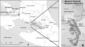
Every autumn, millions of monarch butterflies (Danaus plexippus) migrate from Eastern North America to the high altitude temperate forests of the Monarch Butterfly Biosphere Reserve in central Mexico (Urquhart Reference Urquhart1976; Brower Reference Brower1977) where they spend the winter months from November to March. The monarch butterflies use the closed forest canopy as protection from the wind, rain and snow (Anderson & Brower Reference Anderson and Brower1996). Forest thinning increases the butterfly's vulnerability to bird predation (Alonso-Mejía et al. Reference Alonso-Mejía, Montesinos-Patiño, Rendón-Salinas, Brower and Oyama1998) and increases exposure to cold winter storms that can penetrate the forest canopy and provoke massive mortality (Brower et al. Reference Brower, Kust, Rendón-Salinas, García-Serrano, Kust, Miller, Fernández del Rey, Pape, Oberhauser and Solensky2004). Protecting the monarch butterfly's overwintering forests is critical for the survival of its migration, which is considered unique in the world (Urquhart Reference Urquhart1976), a threatened biological phenomenon (Wells et al. Reference Wells, Pyle and Collins1983) and a top conservation priority (Brower Reference Brower1977; Brower et al. Reference Brower, Castilleja, Peralta, Lopez-Garcia, Bojorquez-Tapia, Diaz, Marmolejo and Missrie2002; Rendón-Salinas et al. Reference Rendón-Salinas, Ibarra-Contreras, Pérez and Galindo-Leal2005). Yet these forests remain threatened. Researchers estimate that the forest degradation rate in the overwintering area is 3% per year (Brower et al. Reference Brower, Castilleja, Peralta, Lopez-Garcia, Bojorquez-Tapia, Diaz, Marmolejo and Missrie2002), more than twice the national deforestation rate for Mexican temperate forests (Mas et al. Reference Mas, Velázquez, Díaz-Gallegos, Mayorga-Saucedo, Alcántara, Bocco, Castro, Fernández and Pérez-Vega2004). The Monarch Butterfly Biosphere Reserve (MBBR) is located in the transverse neo-volcanic mountain range in central Mexico. The Reserve straddles the border between two states, Michoacan and Mexico, between 19° 59′ and 19°18′ N and 100° 09′ and 100° 06′ W (Fig. 1). The MBBR has a core zone (13 551 ha) where no logging is allowed and a buffer zone (42 407 ha) where sustainable forestry is permitted. The core zone is divided into a northern core zone (588 ha), a central core zone (9234 ha) and a southern core zone (3729 ha).
The Monarch Butterfly Biosphere Reserve straddles the border between the State of Michoacan and the State of Mexico. The protected area consists of three core zones and two buffer zones.

The MBBR forest contains pine (Pinus pseudostrobus, P. oocarpa, P. michoacana, P. rudis, P. teocote, P. ayacahuite and P. hartwegii) and fir (Abies religiosa) species between 2400 and 3600 m. Lower altitudes have oak (Quercus laurina, Q. acutifolia, Q. rugosa. Q. castanea, Q. obtusata, Q salicifolgia and Q. crassifolia) and cedar (Cuppresus lindleyi) species (SEMARNAT [Secretaría de Medio Ambiente y Recursos Naturales] 2001). Juniper thickets and large meadows are also found within the MBBR.
The Mexican Government first protected these areas in 1980 by declaring all monarch butterfly overwintering sites a ‘Reserve and Wildlife Zone’ (Diario Oficial 1980). However this declaration failed to designate specific areas for protection (SEMARNAT 2001). Six years later, the federal government established a 16 110 ha protected area (Diario Oficial 1986). This protected area was imposed on the landowners who managed their forests through common property arrangements called ejidos and indigenous communities. Historically, these landowners have been excluded from managing their forests (Klooster Reference Klooster2003; Boyer Reference Boyer, Bray, Merino-Pérez and Barry2005; Bray et al. Reference Bray, Merino-Pérez and Barry2005) and, throughout the 1980s and 1990s, the ejidos and indigenous communities criticized the resource limitations associated with the protected area and the top-down process by which it was imposed (Chapela & Barkin Reference Chapela and Barkin1995; Merino-Pérez Reference Merino-Pérez1995). The boundaries also partially failed from a biological perspective, because the geometric design omitted crucial butterfly habitat (Brower Reference Brower, Hoth, Merino, Oberhauser, Pisanty, Price and Wilkison1999; Hoth et al. Reference Hoth, Merino, Oberhauser, Pisanty and Price1999). In 1998, World Wildlife Fund (WWF) Mexico was invited by the Mexican Government to propose new reserve boundaries based on biological criteria. The Ministry of the Environment used WWF's proposal as the starting point to negotiate new core and buffer zones with property owners (Bojórquez-Tapia et al. Reference Bojórquez-Tapia, Brower, Castilleja, Sánchez-Colón, Hernández, Calvert, Diaz, Gómez-Priego, Alcantar, Melgarejo, Solares, Gutiérrez and Juárez2003; Missrie Reference Missrie, Oberhauser and Solensky2004). In exchange for additional protection, property owners were promised access to a conservation fund that would pay them for meeting conservation goals. In November 2000, Mexican President Ernesto Zedillo declared the new MBBR boundaries which encompassed 40 properties: 22 ejidos, 10 indigenous communities, six individual owners, one state property and one federal property.
The Monarch Butterfly Conservation Fund
The Monarch Butterfly Conservation Fund (MBCF; Fondo para la Conservación de la Mariposa Monarca) is a PES-like scheme that uses direct payments to generate incentives for forest conservation. The fund was established in 2000, in conjunction with the enlargement of the MBBR (Honey-Rosés Reference Honey-Rosés, LeQuesne and McNally2005; Missrie & Nelson Reference Missrie, Nelson and Usha2007). The MBCF holds approximately US$ 6.5 million in capital funds, of which US$ 5 million came from the David and Lucile Packard Foundation, US$ 1 million from the Mexican Federal Government and US$ 0.25 million each from the state governments of Michoacan and Mexico. The MBCF is managed jointly by WWF Mexico and the Fondo Mexicano para la Conservación de la Naturaleza (Mexican Fund for the Conservation of Nature). The programme operates with the interest earnings from the invested capital, which are transferred to a Trust and subsequently disbursed to property owners who have fulfilled their conservation commitments (WWF Mexico 2002). Only properties with land in the core zone of the MBBR are eligible to participate.
The MBCF makes two types of payments to participating landowners. The first payment is made each June, and compensates properties that had logging rights cancelled as a result of the reserve enlargement in 2000. Properties receive an annual payment of US$ 18 m−3 of forfeited timber, according to extraction volumes specified in their management plan. The management plans were based on 10 year cycles, so, at most, the fund anticipated compensating landowners over a period of 10 years for timber extraction. The second payment is made in December of each year, irrespective of logging rights and instead based on the area of conserved forest. All property owners with land in the core zone are eligible for the second conservation payment. Since property owners with logging permits are eligible for two payments a year, and those without logging permits are only eligible for one, out of fairness, it was decided that property owners with only access to conservation payments were to be paid at a higher rate of US$ 12 ha−1, while property owners forfeiting logging rights would receive US$ 8 ha−1 until they stopped receiving June payments for forfeited timber rights.
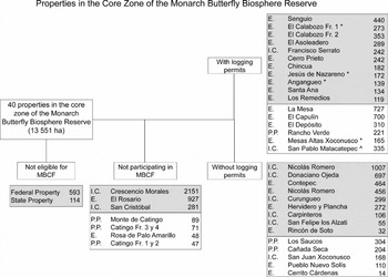
Of the 40 properties in the core zone of the MBBR, the federal and state properties were ineligible to participate in the MBCF. Of the remaining 38 eligible properties, 31 agreed to participate (WWF Mexico 2000, 2002). Less than full participation distinguishes the MBCF from other ‘PES like’ schemes, since most PES programmes tend to be oversubscribed, especially those supported by third parties (Wunder et al. Reference Wunder, Engel and Pagiola2008). The difficulty in attracting participants was symptomatic of local resistance and mistrust directed at conservation initiatives. Among the 31 participants, 17 had logging permits and were eligible for the June payments. However, only 13 of these 17 properties were scheduled to receive payment in June 2003. This was owing to the annual rotation of extraction areas. In some years, the scheduled extraction area fell inside the new core zone of the Reserve while, in other years, the extraction area fell outside the core zone, thereby not creating a payment or conservation commitment. For monitoring purposes, in 2003, this allowed us to concentrate our field sampling on the 13 properties scheduled to receive conservation payments for forfeited logging rights in June 2003 (Fig. 2).
The core zone of the Monarch Butterfly Biosphere Reserve is comprised of 13 551 ha and 40 properties. Those properties highlighted in grey are located in the state of Michoacan, while those in white are in the State of Mexico. The number indicates the number of hectares in the core zone. *Property was not scheduled for an evaluation in June 2003. This was because not all participating properties with logging rights were scheduled to receive compensation payments each year. E = ejido, IC = indigenous community, PP = private property. ^Includes land in dispute.

In preparation for these June 2003 payments, we needed to evaluate which landowners had protected their forest. After exploring multiple options, we selected a combination of remote sensing and field sampling, our criteria for the monitoring method design being timeliness, replicability and cost-effectiveness.
Remote sensing data acquisition
To select remote sensing technology, we compared Landsat imagery, high resolution satellite imagery from IKONOS and digital aerial photography. In balancing these options, we confronted trade-offs between timing, resolution, cost and experience in image handling. To detect selective cutting, we sought images that could cover the entire Reserve (56 259 ha) with the finest possible resolution. Landsat 7 satellite images are the most common source of remote sensing data for studying land-use change (see Mas et al. Reference Mas, Velázquez, Díaz-Gallegos, Mayorga-Saucedo, Alcántara, Bocco, Castro, Fernández and Pérez-Vega2004; Sánchez-Azofeifa et al. Reference Sánchez-Azofeifa, Pfaff, Robalino and Boomhower2007; Andam et al. Reference Andam, Ferraro, Pfaff, Sánchez-Azofeifa and Robalino2008). However, these images have a resolution of only 30 m per pixel. While these images may be appropriate at larger scales, we found they would be insufficient for detecting small-scale changes in the Reserve. In comparison, the high resolution IKONOS satellite images have a multispectral resolution of four metres per pixel and a panchromatic resolution of one metre per pixel. Some researchers have succeeded in using IKONOS imagery to detect selective logging (Furusawa et al. Reference Furusawa, Pahari, Umezaki and Ohtsuka2004). Unfortunately, IKONOS images for the entire MBBR cost US$ 33 000 (J. Smith, personal communication 2003). This option would also oblige us to acquire historical images and consider the additional cost of the change analysis; consequently the estimated cost of using IKONOS imagery escalated to over US$ 60 000.
In contrast, the acquisition of digital aerial photographs, including plane rental and pilot expenses, was quoted at US$ 5000. Furthermore, researchers at the National Autonomous University of Mexico (UNAM) had already acquired aerial photographs for our area of interest on 10 March 2001. These existing photographs were taken five months after the enlargement of the Reserve and thus provided an appropriate base line for our study. One disadvantage was that these photographs did not include the southern and northern core zones. These two areas represented approximately 28% and 4% of the total core zone respectively, and 23 of the 29 participating properties. The missing area also included 2 properties scheduled for evaluation in June 2003.
Advances in digital technology allowed the digital aerial photographs to be acquired at an average pixel resolution of 0.6 m; nearly double the resolution of panchromatic IKONOS satellite images, and over 1000 times the resolution of Landsat. The aerial photographs could also be viewed stereoscopically. Selecting aerial photography also allowed us to work with an experienced team at the Geography Department of UNAM who had already supervised the acquisition and analysis of aerial photographs of the MBBR in 1999 (see Brower et al. Reference Brower, Castilleja, Peralta, Lopez-Garcia, Bojorquez-Tapia, Diaz, Marmolejo and Missrie2002). This prior experience, low cost, high image resolution and quick acquisition, led us to select aerial photography as the remote sensing method of choice.
The digital aerial photographs of the MBBR were taken on 22 and 23 February 2003 at an altitude of 5500 m. The flight patterns were the same as previous years to ensure compatibility between 2001 and 2003, as well as historical comparisons with aerial photographs taken in 1999. Additional flights lines were added in the western part of the Reserve in order to incorporate the recently enlarged buffer zone. The images were taken with a 50% longitudinal overlap and 30% lateral overlap. Once the digital images were acquired, they were printed at a scale of 1:10 000. Beginning in March 2003, the 207 aerial images were analysed using a mirrored stereoscope. The photointerpretation stratified the forest cover into five categories according to canopy density. These five categories are compatible with previous categorizations at this site (for example Brower et al. Reference Brower, Castilleja, Peralta, Lopez-Garcia, Bojorquez-Tapia, Diaz, Marmolejo and Missrie2002). The ‘Closed’ canopy category was defined as an area with canopy density ≥ 80% (Brower et al. Reference Brower, Castilleja, Peralta, Lopez-Garcia, Bojorquez-Tapia, Diaz, Marmolejo and Missrie2002). However we increased precision by splitting two categories into greater detail. ‘Semi-altered’ (30–80%) was divided into ‘Semi-closed’ (55–79%) and ‘Semi-open’ (34–54%) and the category of ‘Open’ (<30%) was divided into ‘Open’ (6–34%) and ‘Deforested’ (0–5%).
The photointerpretation was completed on transparent acetates and then restituted with a Stereosketch (Higher and Watts, New York). The restitution transferred the patches of canopy densities onto a base map with contours every 20 m. We then digitized the map of forest cover classifications at a scale of 1:10 000.
Upon completing the interpretation of the 2003 photographs, the canopy densities on the transparent acetates were compared to the 2001 photographs using a mirrored stereoscope. We used a new technique in which 2001 and 2003 photographs were simultaneously observed through a stereoscope at the same scale. When differences in forest cover were found, the 2001 photographs were interpreted independently. This process followed the same methodology described above (photointerpretation, restitution and digitalization). We obtained digital files of the forest quality in 2001 and 2003 that could be quantified and compared in a geographical information system.
Field sampling
We randomly sampled 15 plots in all but one of the 13 properties scheduled for payment in June 2003. We did not conduct field work in the Indigenous Community of Francisco Serrato because of security concerns related to illegal logging. A planning meeting and training workshop were held on 14 and 31 March 2003. The monitoring methodology was described to property owners, and community members signed up to participate in the field work. In all, 24 people participated in the field sampling between 28 April 2003 and 15 May 2003.
Fifteen randomly distributed transects were distributed in each of the properties being sampled. The transects were 20 m wide and of variable length (76–480 m), in order to sample 2% of each property (SARH [Secretaría de Agricultura y Recursos Hídricos] 1982). Teams counted freshly cut stumps and measured their diameters. We sampled 81 ha.
RESULTS
Aerial photography
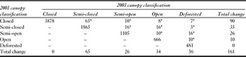
Between 2001 and 2003, 161 ha of fir-pine forest were degraded in the central core zone of the MBBR. Most of the changes occurred in the ‘Closed’ canopy category, where 90 ha were degraded (Table 1).
Forest change transition matrix (in ha) between 2001 and 2003. *Hectares that changed from 2001 (row) to 2003 (column), remaining cells show number of hectares without change. – = No forest recovery was detected.

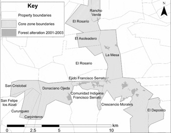
Comparisons of the aerial photographs showed that forest degradation was concentrated in six properties (Fig. 3). Of the properties participating in the MBCF, the Indigenous Community of Francisco Serrato had the highest forest degradation with 47 ha degraded (19% of its core zone). The neighbouring Indigenous Community of Donaciano Ojeda also lost forest quality in 24 ha (3%), although they were not scheduled to receive June 2003 payments from the MBCF. In the state of Mexico, the Ejido La Mesa saw 19 ha degraded (2.6%) and Rancho Verde 3 ha (2%). Two properties not participating in the MBCF also showed forest degradation. The Indigenous Community of Crescencio Morales had the greatest total forest degradation (66 ha) even though it was a small portion of the property (3%). Two hectares were degraded in Ejido El Rosario (0.5%).
Location of forest degradation within the Monarch Butterfly Biosphere Reserve, as detected by the comparison of aerial photographs in the core zone between 2001 and 2003.

Field sampling
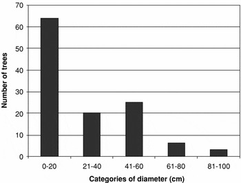
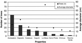
One hundred and nineteen stumps 5–100 cm in diameter were recorded. Over 50% of the stumps were < 20 cm in diameter (Fig. 4). Eight of the 12 properties sampled showed some evidence of recent tree removal. The Ejidos El Asoleadero and El Depósito had an average of eight and four trees cut per hectare respectively, while the other six properties had an average of two trees removed per hectare or less. Different properties were extracting trees of different sizes (Fig. 5). Although few trees were cut in the Ejido La Mesa, they were comparatively large. Large trees were also being extracted in El Depósito. The average size of tree cut in the other properties was c. 20 cm.
The distribution of the 119 recorded tree stumps by diameter size.

Number of trees removed and their average diameter in each property.

DISCUSSION
The photointerpretation showed no changes occurred in 23 of the 29 properties, while field sampling showed little extraction in 10 of 12 of the properties sampled. This suggests that most property owners were respecting the new MBBR boundaries. More significantly, properties that previously had logging permits were found to have effectively ceased logging. While a comprehensive evaluation of the MBCF's impact is beyond the scope of this article, at first glance, the MBCF retired6009 m3 of timber during the 2003 harvest cycle because this was the volume that would have been extracted legally without the new protected area and MBCF. However, it remains possible that logging moved elsewhere in what is referred to as ‘leakage’.
While we would like to attribute additional forest protection to the operation of the MBCF, this is not possible with only two years of data. The wealth of data needed to make reliable claims about additionality has generated a significant gap in the PES field (Wunder et al. Reference Wunder, Engel and Pagiola2008). Even in the literature on protected areas, a much older conservation tool, new studies are just beginning to provide convincing evidence of additionality provided by protected area status (Andam et al. Reference Andam, Ferraro, Pfaff, Sánchez-Azofeifa and Robalino2008). Among the few researchers that have quantified the impact of PES-like schemes (Tattenbach et al. Reference Tattenbach, Obando and Rodríguez2006; Sánchez-Azofeifa et al. Reference Sánchez-Azofeifa, Pfaff, Robalino and Boomhower2007; Pfaff et al. Reference Pfaff, Robalino and Sanchez-Azofeifa2008) results are largely mixed. According to Wunder et al. (Reference Wunder, Engel and Pagiola2008), only Pagiolia and Rios (Reference Pagiola and Rios2008) have systematically and formally quantified additionality in PES payments with ex-ante scenarios. Therefore in this study we moderate claims about additionality, even though the monitoring method and the enforcement of payment conditionality presented here are essential prerequisites for eventually studying a programme's impact.
On 9 June 2003, the Technical Committee of the Monarch Trust used these monitoring results to approve conservation payments for 12 of the 13 property owners participating in the Monarch Butterfly Conservation Fund. The Committee used the following decision rule: payment was denied to those with forest alteration > 3% of their property in the core zone, a warning was given to properties with forest alteration between 2 and 2.9%, and full payment was given to properties with forest alteration < 2%. The percentages were based on the recent forest degradation rate of 3% in the Reserve during the period 1984–1999 (Brower et al. Reference Brower, Castilleja, Peralta, Lopez-Garcia, Bojorquez-Tapia, Diaz, Marmolejo and Missrie2002). This decision rule was intended to hold property owners accountable for at least reducing degradation rates. The application of the rule resulted in the withholding of payment from one community. The MBCF is one of the few PES-like programmes to withhold payment from participants as a result of systematic forest monitoring. This work was completed in five months for a total cost of US$ 17 000. In comparison, that same year, the MBCF paid participants US$ 203 454 in June and US$ 87 396 in December, a total of US$ 290 850.
Our case study provides methodological lessons for PES programmes. Despite obtaining aerial photographs at a very high pixel resolution (0.6 m), we did not detect individual tree extractions that were later found during field work. This was not because these extractions were undetectable, since viewing the high resolution images stereoscopically permits the identification of individual tree loss. Rather, these finer scale changes were not reported because the photointerpretation method is based on the classification of canopy density, and the extraction of individual trees was insufficient to alter the canopy classification from one category to another. Searching for individual tree extractions is technically possible, but impractical for a large study area. The difficulties in detecting finer scale changes, despite having a resolution over 1000 times greater than Landsat satellite imagery, leads us to suspect that conservation programmes reliant on Landsat are underestimating forest loss and overpaying non-compliant actors. If this is the case, then the land-use changes widely reported in the literature are also probably underestimates of the real changes in the landscape.
Other lessons pertain to the process of making payment decisions. Creating a decision rule for withholding payment is essential for meeting the conditionality feature of a PES programme. Reviews of existing direct payment programmes stress the importance of payment conditionality (for example Pagiola et al. Reference Pagiola, Bishop and Landell-Mills2002; Sánchez-Azofeifa et al. Reference Sánchez-Azofeifa, Pfaff, Robalino and Boomhower2007; Wunder Reference Wunder2007) yet provide no guidance as to how to establish rules of engagement. Creating a decision rule, or establishing a threshold for withholding payment, generates new dilemmas for PES managers. Where should the threshold for payment be located? Should PES programmes withhold payment when 100 trees are extracted, or 20 trees, or just one tree? If the threshold is too low, the smallest level forest change may disqualify property owners from receiving payment. Participants might feel unfairly punished for only small changes in land cover, or be discouraged from participating in the PES programme in the future. Conversely, if the threshold is too high and permits considerable land-use change before withholding payment, the programme may pay non-compliant landholders.
The dilemma regarding where to place the payment threshold resembles the balancing act between Type I and Type II statistical errors. PES managers will need to decide which undesirable situation is preferable: either payment when significant land-use change has occurred, or withholding payment under conditions of very minor environmental change. In the case of the MBCF, this dilemma emerged during the decision-making process, because payment thresholds were not established in the design phase of the programme. Declaring a decision rule from the outset may appear to resolve this issue, however, declaring a permissible level of environmental change may encourage landowners to engage in strategic behaviour and exploit just below the permissible level. Therefore in order to meet the conditionality feature of a PES programme, managers are forced to create decision rules that inherently will balance competing risks.
In addition, the selection of payment thresholds may lack ecological and economic justification. Ideally, both payments and payment thresholds would reflect the marginal values of the ecosystem services provided. However, until economists and ecologists devise methods to calculate marginal values for ecosystem services of ecosystem services, these thresholds will lack formal reasoning. Since the tools needed to calculate marginal values are unlikely to emerge anytime soon, this problem will remain with PES managers in the near future. At best, payment thresholds can be justified using policy objectives. This was the strategy adopted by the Technical Committee of the Monarch Trust, which chose a decision rule based on the objective of reducing recent deforestation rates.
Lastly, the MBCF tested how direct payments operate with insecure property rights and illegal logging. Illegal logging has been identified as the most significant proximate factor of deforestation in the MBBR (Honey-Rosés Reference Honey-Rosés2009). Community leaders filed complaints about illegal logging and took direct measures, such as the obstruction of logging roads, to prevent loggers from entering their properties (WWF Mexico 2004). Some members of the Trust Fund's Technical Committee argued that the Fund should pay for lands illegally logged if the owners could demonstrate that they were not responsible. This proposition is problematic, both because responsibility is difficult to assign and because the fund would simultaneously pay those who protected their forest, and those who did not. Our experience reinforces the suggestion that insecure property rights or weak legal enforcement will debilitate the operation of direct payment schemes (Ferraro Reference Ferraro2001; Wunder Reference Wunder2006; Wunder Reference Wunder2007). It is especially important that property owners have the power to restrict access to their resources. The Mexican Federal government addresses timber theft in their PES programme by offering the proportional value of the payment per hectare in the event that timber was stolen or destroyed in a forest fire (Muñoz-Piña et al. Reference Muñoz-Piña, Guevara, Torres and Braña2008). More recently, the MBCF has paid communities with deforestation from illegal logging, but restricted the use of these funds to support community-based law enforcement measures, such as forest patrols.
Establishing an effective monitoring method to inform payment decisions requires interdisciplinary teams with expertise in remote sensing, forestry, environmental economics and research design. Existing remote sensing data and methods for monitoring forest cover cannot detect changes at finer scales. This suggests that current PES and PES-like schemes are underestimating the land-use changes and overpaying non-compliant participants. Even in cases where precise data on environmental change are obtained, sound decisions about withholding payment rely on understanding of the marginal values of ecosystem services. In the future, as technology increases the ability to observe changes at smaller scales, the question of how to make payment decisions in PES programmes will attract more attention.
ACKNOWLEDGEMENTS
We are grateful to L.P. Brower, P. Angeles, I. Contreras, M.A. Bernal, G. Castilleja, S. Knaebel, M.A. Jorge, S. Hutchison, L. Aviña, L. Rosenzweig, R. González, C. Karr, R. Scott, A. Gillespie, D. Slayback, D. Walker, S. Wunder, D. Schneider and several anonymous reviewers. Financial support for this project came from the David and Lucile Packard Foundation and the Forest Programme of WWF UK.