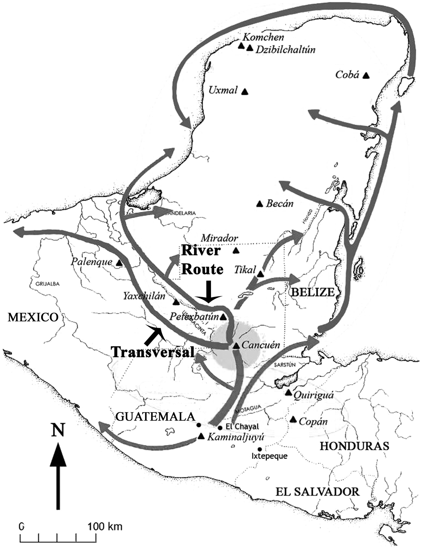
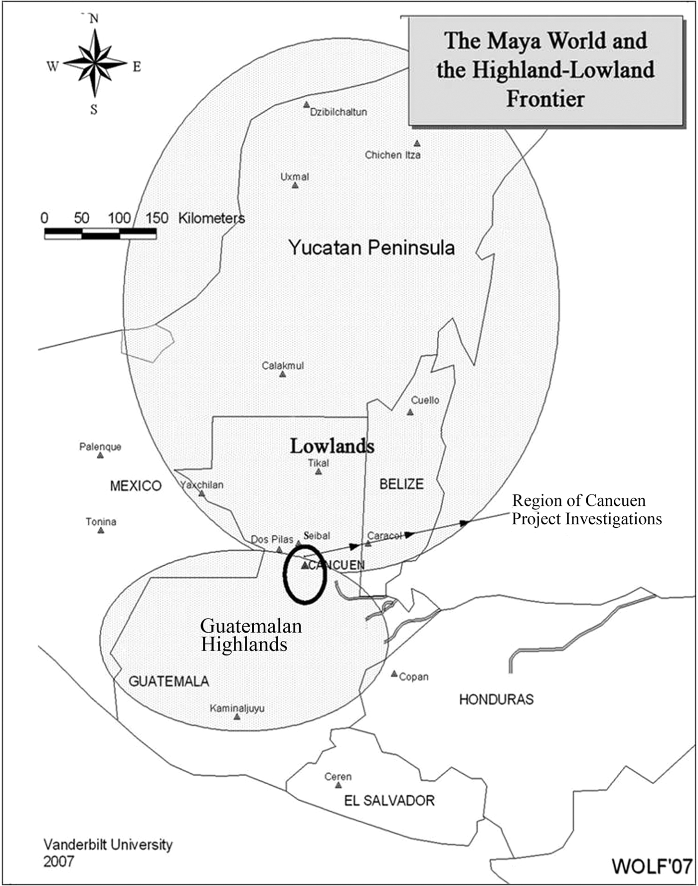
The 13 large-scale field seasons and 14 years of laboratory research by over 40 scholars at the royal port city of Cancuen have provided important evidence on the nature of eighth-century changes in Classic Maya interregional economy. Excavations and laboratory analyses have been reported in more than 200 articles, chapters, or reports, most in Spanish (see, for example, Andrieu and Forné Reference Andrieu, Forné, Arroyo, Palma and Aragón2010; Andrieu et al. Reference Andrieu, Jaime-Riverón, Tenorio, Calligaro, Ocampo, Jiménez, Ostrooumov, Arroyo, Palma and Aragón2011, Reference Andrieu, Rodas and Luin2014; Andrieu, Quiñonez, and Rodas Reference Andrieu, Quiñonez, Rodas, Demarest, Martínez, Quintanilla and Torres2011; Barrientos Reference Barrientos2014; Barrientos and Demarest Reference Barrientos, Demarest, Laporte, Arroyo and Mejía2007; Barrientos et al. [eds.] Reference Barrientos, Demarest, Luin, Quintanilla and Mencos2006; Demarest and Barrientos Reference Demarest and Barrientos1999, Reference Demarest and Barrientos2000, Reference Demarest and Barrientos2001; Demarest et al. Reference Demarest, Barrientos, Kovacevich, Callaghan and Luin2002, Reference Demarest, Barrientos, Kovacevich, Callaghan, Woodfill and Luin2003; Demarest et al. [eds.] Reference Demarest, Martínez and Luin2007, Reference Demarest, Martínez, Forné, Quintanilla and Luin2008, Reference Demarest, Martínez, Quantanilla and Torres2011, Reference Demarest, Martínez, Torres, Forné, Quintanilla, Torres and Luin2012; Demarest and Martínez Reference Demarest and Martínez2010, Reference Demarest and Martínez2013; Fahsen and Barrientos Reference Fahsen, Barrientos, Barrientos, Demarest, Luin, Quintanilla and Mencos2006; Fahsen et al. Reference Fahsen, Demarest, Luin, Laporte, Suasnávar and Arroyo2003; Fahsen and Jackson Reference Fahsen, Jackson, Demarest and Barrientos2001; Forné et al. Reference Forné, Alvarado, Torres, Belches, Demarest, Martínez, Forné, Quintanilla and Luin2008, Reference Forné, Bishop, Demarest, Blackman, Sears, Arroyo, Aragón, Palma and Arroyave2010, Reference Forné, Andrieu, Demarest, Torres, Quintanilla, Bishop, Riveron, Arnauld and Breton2013; Forné and Torres Reference Forné, Torres, Demarest and Martínez2010; Torres et al. Reference Torres, Orantes, Saravia, Tuyuc, Demarest and Martínez2013; Urquizu et al. Reference Urquizú, Cifuentes, Nij, Demarest and Martínez2013; Wolf and Bracken Reference Wolf, Bracken, Demarest and Martínez2013a). The location of the site at the head of navigation of the Pasión River facilitated its role as a port and a gateway, linking highland valley land routes to the south with the lowlands to the north via the broad river highway of the Pasión, which flows north through the Peten past many of its cities and connecting to tributaries and major land routes (Figure 1). Cancuen lies at the direct interface between highlands and lowlands (Figure 2), controlling the beginning of one of the longest trade routes of the ancient Maya world. Thus, it held a strategic position in Classic Maya exchange systems, a fact acknowledged by the history of actions of the Classic Maya dynasties and alliances to secure this nexus of terrestrial and riverine routes. The epicenter of Cancuen and its adjacent zones have clear evidence for ports and port economy. Examination of this evidence in field, laboratory study, and comparative perspective provides some insights into Maya economy, elite control, and changes in power and hegemony on the eve of the Classic Maya “collapse.”
Some of the principal exchange and transport routes of the Classic Maya world.

Cancuen region at the valley interface of the highland and lowland Maya worlds.
Before turning to the nature and history of Cancuen as a port city and aspects of its economy, we should specify the focus of this particular article and then review some theoretical issues. Note that many other recent publications, cited for various specific interpretations, deal more directly and in detail with the specific evidence on aspects of Cancuen including the most recent analyses of the obsidian assemblage (Andrieu, Quiñonez, and Rodas Reference Andrieu, Quiñonez, Rodas, Demarest, Martínez, Quintanilla and Torres2011; Andrieu et al. Reference Andrieu, Quiñonez, Rodas, Demarest, Martínez, Quintanilla and Torres2011, Reference Andrieu, Forné, Demarest, Wiesheu and Guzzy2012), ceramics and chronology (Forné et al. Reference Forné, Bishop, Demarest, Blackman, Sears, Arroyo, Aragón, Palma and Arroyave2010, Reference Forné, Andrieu, Demarest, Torres, Quintanilla, Bishop, Riveron, Arnauld and Breton2013 Forné and Torres Reference Forné, Torres, Demarest and Martínez2010; Torres et al. Reference Torres, Orantes, Saravia, Tuyuc, Demarest and Martínez2013), ideological systems legitimating economic power (Barrientos Reference Barrientos2008, Reference Barrientos2014; Barrientos and Demarest Reference Barrientos, Demarest, Laporte, Arroyo and Mejía2007, Reference Barrientos, Demarest and Cabezas2012; Barrientos et al. Reference Barrientos, Demarest, Alvarado, Martínez, Wolf, Luin, Laporte, Arroyo and Mejía2006; Demarest Reference Demarest2013); the extent of the site and its sustaining area (Demarest Reference Demarest2013; Demarest et al. Reference Demarest, Martínez, Wolf, Torres, Belches, Andrieu, Luin, O'Mansky, Quintanilla, Laporte, Arroyo and Mejía2009, Reference Demarest, Martínez, Torres, Urquizu, O'Mansky, Wolf, Saravia, Cifuentes, Coji, Andrieu, Saravia, Luin, Tuyuc, Bracken, Arroyo, Salinas and Aragón2013; Wolf and Bracken Reference Wolf, Bracken, Demarest and Martínez2013a), epigraphy and political relations (Barrientos Reference Barrientos2014; Fahsen and Barrientos Reference Fahsen, Barrientos, Barrientos, Demarest, Luin, Quintanilla and Mencos2006; Fahsen et al. Reference Fahsen, Demarest, Luin, Laporte, Suasnávar and Arroyo2003; Fahsen and Jackson Reference Fahsen, Jackson, Demarest and Barrientos2001; Jackson Reference Jackson, Laporte, Arroyo, Escobedo and Mejía2004, Reference Jackson2005), new understandings of Cancuen's role in nonexotic, basic commodity production and exchange (Demarest and Martínez Reference Demarest and Martínez2013; Demarest et al. Reference Demarest, Martínez, Torres, Urquizu, O'Mansky, Wolf, Saravia, Cifuentes, Coji, Andrieu, Saravia, Luin, Tuyuc, Bracken, Arroyo, Salinas and Aragón2013), corrected and new analyses of jade working (Andrieu et al. Reference Andrieu, Quiñonez, Rodas, Demarest, Martínez, Quintanilla and Torres2011, Reference Andrieu, Forné, Demarest, Wiesheu and Guzzy2012, Reference Andrieu, Rodas and Luin2014; Andrieu, Quiñonez and Rodas Reference Andrieu, Quiñonez, Rodas, Demarest, Martínez, Quintanilla and Torres2011), the significance of local ceramic types and imports (Torres et al. Reference Torres, Orantes, Saravia, Tuyuc, Demarest and Martínez2013), and instrumental neutron activation analysis (INAA) of both (Bishop et al. Reference Bishop, Sears and Blackman2005; Forné et al. Reference Forné, Bishop, Demarest, Blackman, Sears, Arroyo, Aragón, Palma and Arroyave2010; Torres et al. Reference Torres, Orantes, Saravia, Tuyuc, Demarest and Martínez2013), cave ritual (Spenard Reference Spenard2006; Woodfill Reference Woodfill2010; Woodfill and Andrieu Reference Andrieu2012), frontier relations (Demarest and Martínez Reference Demarest and Martínez2013; Demarest et al. Reference Demarest, Martínez, Torres, Urquizu, O'Mansky, Wolf, Saravia, Cifuentes, Coji, Andrieu, Saravia, Luin, Tuyuc, Bracken, Arroyo, Salinas and Aragón2013; Wolf and Bracken Reference Wolf, Bracken, Demarest and Martínez2013b), and evidence on Cancuen's violent collapse (Demarest Reference Demarest and Iannone2014; Demarest et al. Reference Demarest, Quintanilla, Suasnavar, Iannone, Houk and Schwake2014; Quintanilla Reference Quintanilla2013; Quintanilla and Demarest Reference Quintanilla, Demarest, Arroyo and Méndez2013; Suasnávar et al. Reference Suasnávar, Robinson, Quezada, Ixpatá, Vásquez and Ixcot2007; Winburn et al. Reference Winburn, Tung, DeSantis and Quintanilla2013. These are referenced here, and they provide detail on elements referred to in this synthetic article by the Cancuen subproject directors.
Here the focus is primarily on the epicenter port area of the site, not the site as a whole. The “Greater Cancuen” area extends for several kilometers beyond the epicenter peninsula, depending on direction (Demarest and Martínez Reference Demarest and Martínez2013; Demarest et al. Reference Demarest, Martínez, Torres, Urquizu, O'Mansky, Wolf, Saravia, Cifuentes, Coji, Andrieu, Saravia, Luin, Tuyuc, Bracken, Arroyo, Salinas and Aragón2013). Detailed mapping and excavations are underway on the 4 km transect east (Wolf and Bracken Reference Wolf, Bracken, Demarest and Martínez2013a). Cave shrines 8 to 12 km from the epicenter have been excavated and there the very characteristic Cancuen ceramic assemblage ends (Demarest Reference Demarest2013; Spenard Reference Spenard2006; Torres et al. Reference Torres, Orantes, Saravia, Tuyuc, Demarest and Martínez2013; Woodfill Reference Woodfill2010). Also, recent fieldwork has included excavation of neighboring highland sites (Demarest et al. Reference Demarest, Martínez, Torres, Urquizu, O'Mansky, Wolf, Saravia, Cifuentes, Coji, Andrieu, Saravia, Luin, Tuyuc, Bracken, Arroyo, Salinas and Aragón2013; Demarest and Martínez Reference Demarest and Martínez2013; O'Mansky et al. Reference O'Mansky, Steeves, Newton, Morris, Demarest and Martínez2013; Torres et al. Reference Torres, Orantes, Saravia, Tuyuc, Demarest and Martínez2013; Wolf and Bracken Reference Wolf, Bracken, Demarest and Martínez2013b), as well as further investigation of the complex peninsular epicenter (Demarest and Martínez Reference Demarest and Martínez2010; Demarest et al. Reference Demarest, Wolf, Martínez, Valle, Barrientos, Quiñones, Rodas, Luin, Ajin, Arroyo, Aragón, Palma and Arroyave2011, Reference Demarest, Martínez, Torres, Forné, Quintanilla, Torres and Luin2012). Port and related activities and much public architecture, as well as residences, were concentrated in that epicenter.
A FEW POINTS ON THEORY, TERMINOLOGY, AND EVIDENCE
Recent Relativistic Perspectives on Ancient Maya Economy
One stylistic trope that will be avoided here is to posit that the new evidence overturns the “traditional model” of Classic Maya economy, power, and/or exchange. There is no traditional model (unless one evokes once more the ghost of J. E. S. Thompson from the 1940s). Rather, for decades there has been long-standing healthy debate regarding the nature of Classic Maya economy and the role of elites in it (see, for example, Chase and Chase Reference Chase and Chase1992, Reference Chase and Chase2014; Masson and Freidel Reference Masson and Freidel2002, Reference Masson, Freidel, Hirth and Pillsbury2013; Schortman and Urban Reference Schortman and Urban2004a; Tourtellot et al. Reference Tourtellot, Sabloff, Carmean, Chase and Chase1992; and see below regarding other recent critiques). Those debates center around several issues, including the degree of elite involvement in various aspects of economy such as exchange, production, and infrastructure. In the past, such debates were diverted into contrasting Classic versus Postclassic models, as absolutes, or contrasting universal models of regal-ritual versus unitary states, and so on. Increasingly, however, it is recognized that models of both ideology and economic power should be more complex and that Classic Maya intersite, interregional, and chronological variability was very great. Therefore, we should address these issues in relative—not absolute—terms with a recognition of the multiplicity and great variability in Mesoamerican (including Classic Maya) politics and economy (compare, for example, Aoyama Reference Aoyama1999, Reference Aoyama2007; Braswell Reference Braswell, Garraty and Stark2010; Chase and Chase Reference Chase and Chase1996; Demarest Reference Demarest2009; Fox et al. Reference Fox, Cook, Chase and Chase1996; McAnany Reference McAnany, Sabloff and Henderson1993, Reference McAnany2010; McAnany et al. Reference McAnany, Thomas, Morandi, Peterson, Harrison, Masson and Freidel2002; Rice Reference Rice2009; Schortman and Urban Reference Schortman and Urban2004a; Schortman et al. Reference Schortman, Urban and Ausec2001; Shaw Reference Shaw2012; Wells Reference Wells2006).
Accepting the latter point allows us to assert, in relative terms only, that most Maya centers in the southern lowlands in the full Classic period (in contrast to some central Mexican and Postclassic period states) appear to have been characterized by relatively less direct state involvement in economic infrastructure, somewhat less important interregional markets, and a relatively greater reliance on local or subregional tribute, or “tithing,” as sources of economic support for the elites and for their architectural, artifactual, and ritual expenses (see McAnany [Reference McAnany2010, Reference McAnany, Hirth and Pillsbury2013] for comparative and chronologically sensitive discussion of the latter point). Most Classic period Maya state economies appear to have been largely sustained in their basic subsistence necessities within a more limited region. This is a pattern appropriate to the varied, but still less variable, Peten lowland subsistence environment relative to, for example, highland Mexico. By putting assessments in relative terms, we avoid the ubiquitous stylistic and analytical fallacy of “hyperbolizing the argument of the other.”
Even in the Classic period, the variability between megasites in the lowlands, such as Calakmul, Tikal, Coba, or Caracol, and the vast majority of Maya polities is great, with the average site probably far more reliant on local ideological and military authority and usually only tied via tribute to those greater centers of power—at least in economic terms. Interregional variability is also pronounced, to some degree responding to ecological parameters (Scarborough et al. Reference Scarborough, Valdez and Dunning2003), when one contrasts the complex political economy and ecology of a northern lowland center, particularly a port city, such as Chunchucmil (Dahlin Reference Dahlin2009; Hutson et al. Reference Hutson, Hixson, Magnoni, Mazeau and Dahlin2008), with the majority of southern lowland Classic Peten sites. Finally, as emphasized in this article, variation over time in state or elite economic roles is not only pronounced, but may be the factor of greatest interest to our understanding of the dynamics of economy in the history of Classic Maya states.
A major issue in understanding the diversity of Maya economies and their degree of commercialization is the quantity of goods produced and exchanged through time (Hirth and Pillsbury Reference Hirth and Pillsbury2013; Smith Reference Smith2004). Here we argue that at Cancuen there was an intensification of the production and exchange of goods in the last four decades of occupation, and that elites were probably directly supervising the major ports in the site epicenter and production of some resources, even in initial stages. We also speculate here that the centralized ruler's power, in relation to merchant elites, was waning at the end of the eighth century.
Control of Production and Exchange of Goods
Despite the variety of means and reasons for control documented in anthropology (Costin Reference Costin, Feinman and Price2001:299; Reference Costin, Hruby and Flad2007; McAnany Reference McAnany2010:205), we are usually very limited in our interpretation of the archaeological data, and propinquity between elite structures and workshops has been the most used criterion to recognize attached work, with the idea that it could imply elite supervision of workshops (Clark Reference Clark and Hirth2003; Clark and Parry Reference Clark and Parry1990; Costin Reference Costin, Feinman and Price2001). This criterion has been recently criticized, and various authors have underlined that there is no need to supervise work to control it and vice versa (Clark Reference Clark and Hirth2003; Costin Reference Costin, Feinman and Price2001, Reference Costin, Hruby and Flad2007; Flad Reference Flad, Hruby and Flad2007). In fact, supervision of work is only one of the possible means of controlling production, which can also be controlled by restricting the access of the producers to the raw material or by centralizing a part or the totality of the distribution of the final products (Costin Reference Costin, Feinman and Price2001). Patterns, therefore, such as the exclusion of the producers from the finished artifacts (Andrieu et al. Reference Andrieu, Rodas and Luin2014), or patterns of exclusiveness in the distribution of certain artifacts (Aoyama Reference Aoyama2001), would appear to be a much more effective criterion. It has been argued, however, that the latter would be difficult to distinguish from consumption by wealthy consumers (Clark Reference Clark and Hirth2003), and such patterns should be compared to data on the organization of the corresponding production. Centralization of certain specific production waste in elite contexts is another element that could indicate either embedded production, elite direct participation in the production process (Inomata Reference Inomata2001), or hierarchized control of production (Pool et al. Reference Pool, Knight and Glascock2014). In all cases, we suggest that the use of a single criterion is probably not enough and that such complex relationships such as power relations of production should be demonstrated by correlating different parameters.
Because the word “control” covers a wide variety of cases, and social and economic relations, in this article we specify in some cases these various power relations by using different terms. We will use the term “supervision” to designate control through propinquity, “participation” to refer to forms of embedded production, “priority of access” to designate evidence of control of distribution, and “claims of control” to indicate evidence of symbolic control over certain production activities.
Control of Long-Distance Exotics Exchange Routes
One area of the debate on elite involvement, participation, supervision, and/or priority of access concerns the routes of long-distance exchange. The intensity of long-distance exchange and the frequency of travel involved have never been very clearly understood. While many authors underline that most goods traded over long distances were primarily very highly valued goods, gifted in low quantities, the long-distance exchange of obsidian, cacao, and salt was more complex, and many questions remain (Woodfill and Andrieu Reference Andrieu2012). Others have recently argued that the quantities of goods involved in the tribute system could imply that other materials had to be traded in order to pay that tribute (McAnany Reference McAnany, Hirth and Pillsbury2013). In that context, it would have been critical for many cities to assure their access to major trading routes.
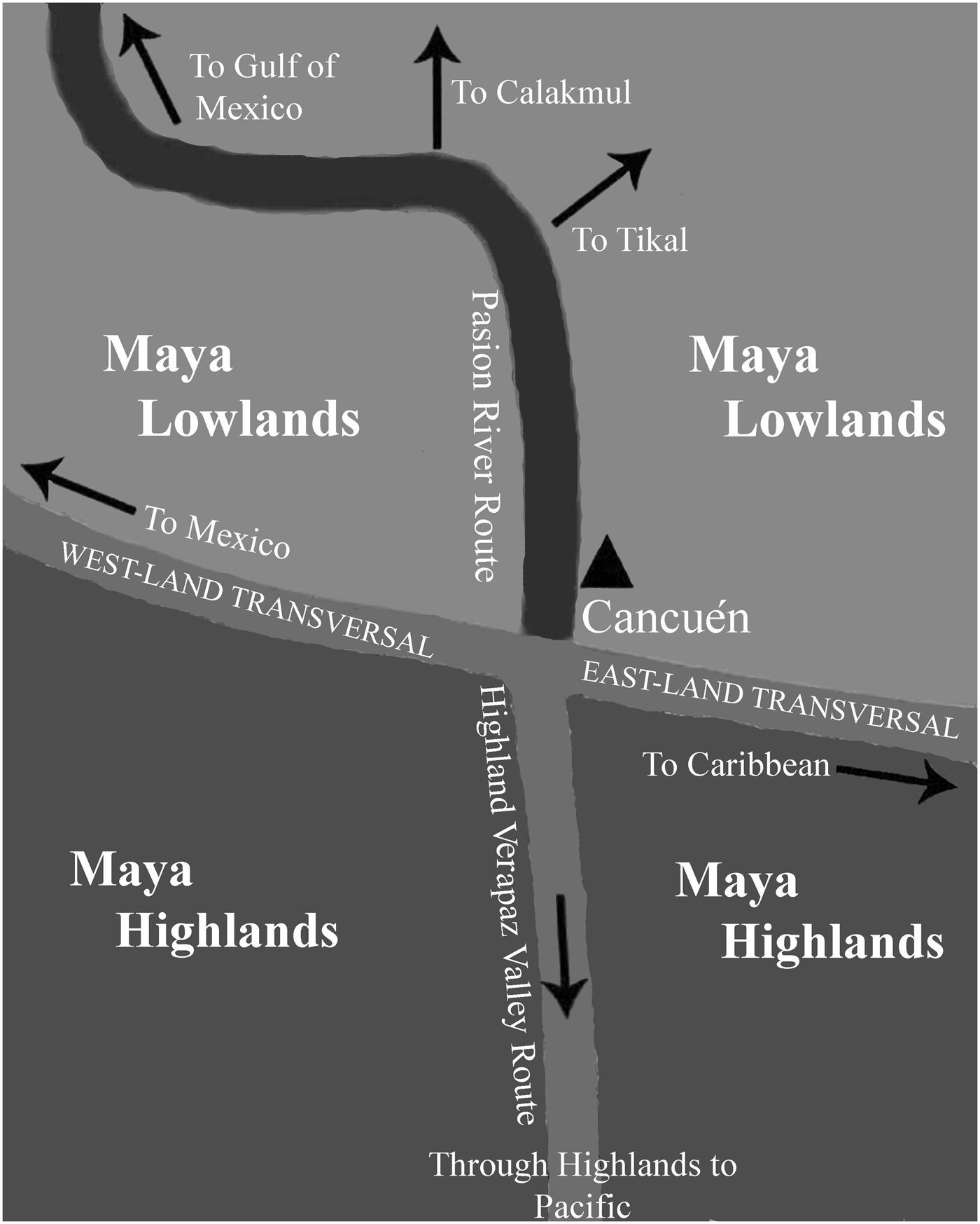
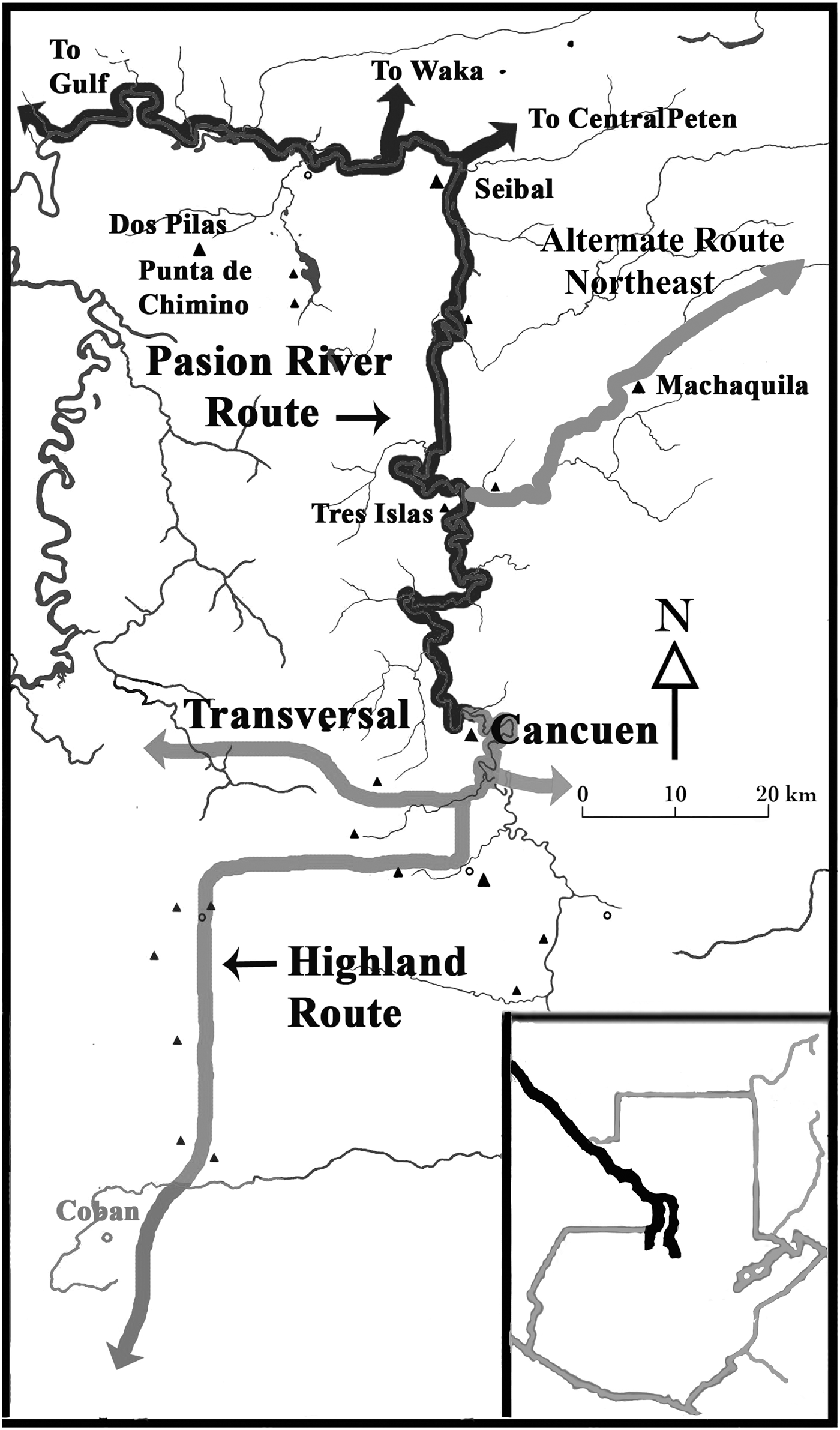
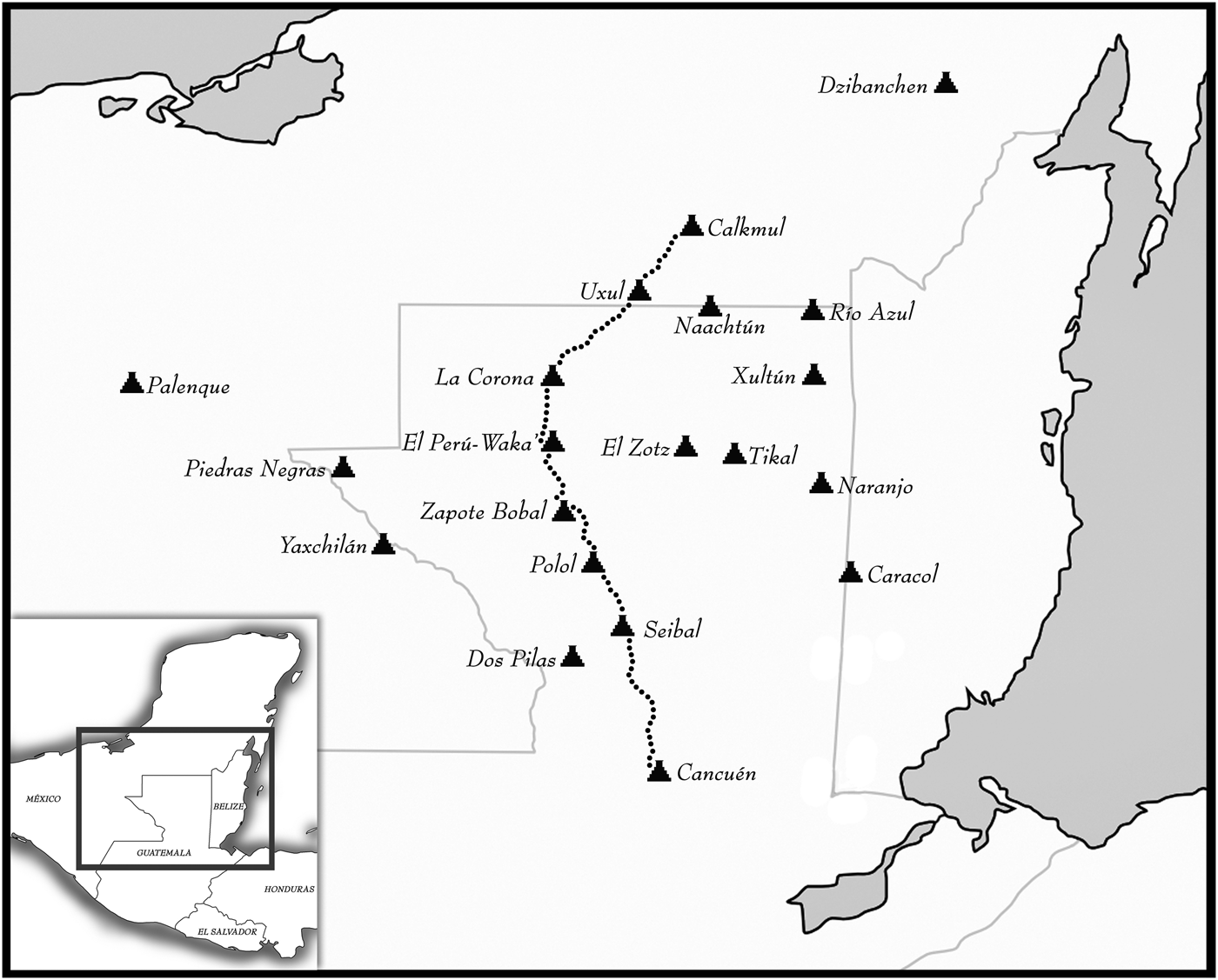
This pattern is especially evident in the southwestern Peten where the access to the Pasión/Usumacinta trade and transport artery was critical to Classic Maya civilization. In the west, there was a linear trade route on the long, wide, and highly navigable Pasión river, which connected the western and central highlands with the Peten and then, via the Usumacinta, to the Gulf of Mexico in the north and through the highlands and Motagua Valley to the south (Figures 1–4). Major Classic period sites are placed at portages and conjunctions of tributaries along this route, and the main river routes also connect to Peten land routes. One of these was what Freidel, Canuto, and Barrientos refer to as the “royal road” from the highlands through Cancuen down the Pasión River and then by land to Calakmul (Canuto and Barrientos Reference Canuto and Barrientos2013; Freidel et al. Reference Freidel, Escobedo, Guenter, Sabloff and Fash2007) (see Figure 5). This route could have connected these sites in order to secure the transport of precious goods from the highlands, Pacific coast, and Motagua Valley. The epigraphic chronology and history of alliances and wars recorded in monumental texts, as well as changing material culture, show the attempts to maintain privileged access, or unify, this western route. This occurred in a series of well-documented historical episodes including: (1) Early Classic Tikal or central Peten fifth- and sixth-century expansion along the river valley through Tres Islas, Punta de Chimino, and other Pasión Valley sites, and on into the highland land corridor, establishing cave shrines all along this route which had Central Peten Tzakol ceramic offerings (Bachand Reference Bachand2010; Demarest et al. Reference Demarest, Woodfill, Barrientos, Fahsen, Monterroso, Laporte, Arroyo and Mejía2007; Woodfill Reference Woodfill2010; Woodfill and Andrieu Reference Andrieu2012); (2) later sixth- and seventh-century Calakmul versus Tikal wars and alliances centering on the control of Dos Pilas, El Peru-Waka, Cancuen, and the other western river and land route centers (Demarest Reference Demarest2006; Martin and Grube Reference Martin and Grube1994, Reference Martin and Grube2008); (3) subsequent Calakmul alliance control of the western route (Figure 5), as verified in the texts of the Petexbatun, El Peru-Waka, La Corona, Cancuen, and other centers in their recorded wars and alliances in the seventh century (Canuto and Barrientos Reference Canuto and Barrientos2013; Freidel et al. Reference Freidel, Escobedo, Guenter, Sabloff and Fash2007; Martin and Grube Reference Martin and Grube1994, Reference Martin and Grube2008); (4) after the a.d. 695 defeat of Calakmul by Tikal, the Dos Pilas hegemony expansion of its Petexbatun kingdom and its (approximately a.d. 730) marriage alliance with Cancuen to control the Pasión River portion of the route (Demarest Reference Demarest2006; Houston Reference Houston1993; Houston and Stuart Reference Houston, Stuart, Demarest and Houston1990); and (5) after the a.d. 761 fall of Dos Pilas, the political disintegration of numerous Pasión River states, but with Cancuen's greatest florescence as the sole controlling power on the Upper Pasión (north-south) River route and with access to the connecting transversal (east-west) route (Figures 4, 5, and 6). In each case, shifts in alliance are celebrated at many sites in texts and are materialized in changes in architecture, monuments, and artifacts (including compositionally traced ceramics and lithics), showing that these different strategies had a clear economic impact on the access of each city to long-distance trade.
Schematic conceptual representation of the strategic position of Cancuen at the intersection of the north-south (river to highlands) and east-west (transversal) transport routes. Drawing by Luis F. Luin.

The specific routes of the highland Verapaz valley, the “transversal,” and the Pasión River.
The “royal road” from the Cancuen head of navigation to Calakmul, as hypothesized by Freidel, Canuto, and Barrientos. Map after Canuto and Barrientos [2013:Figure 1].
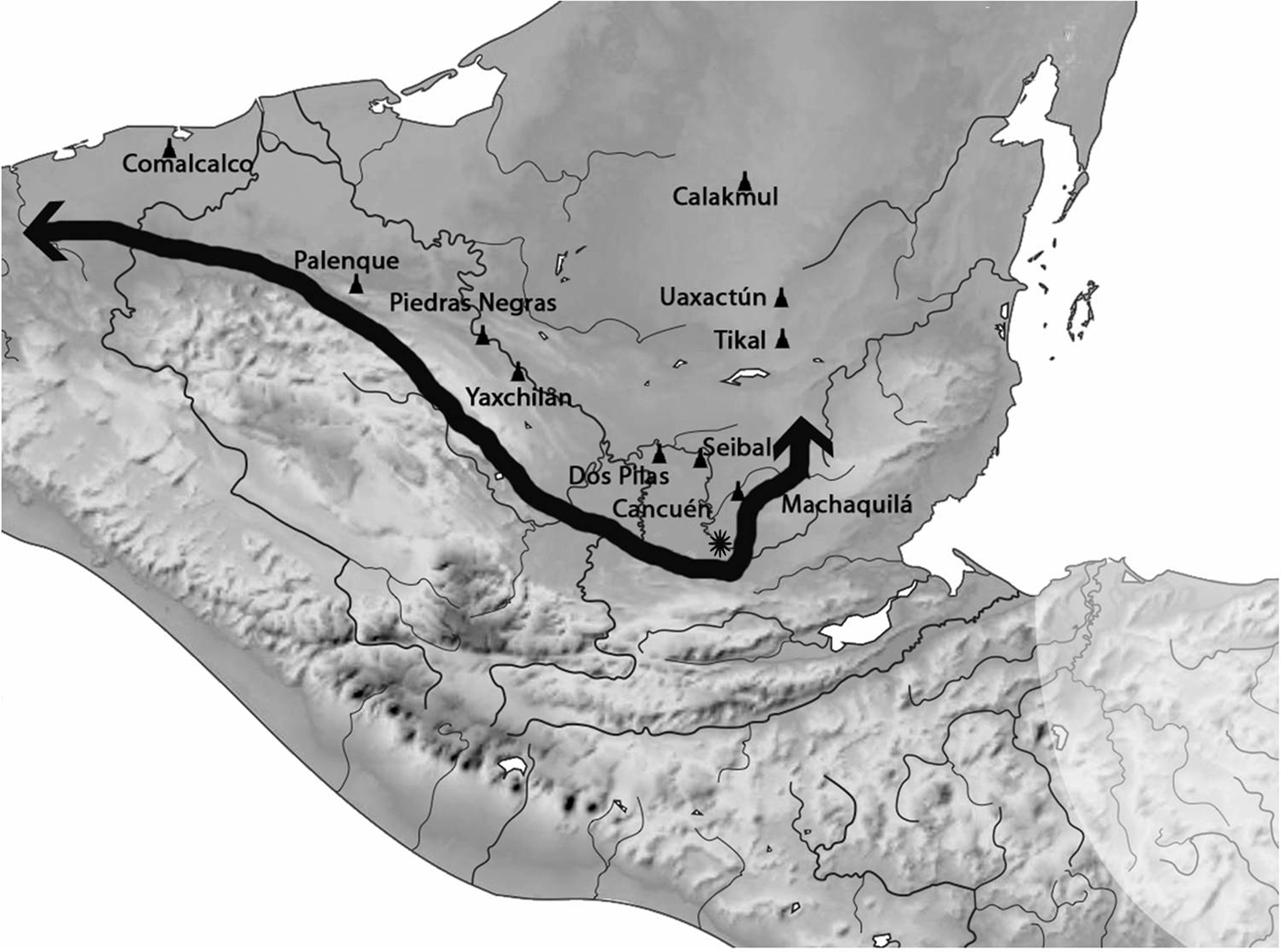
The “Great Detour” of Taj Chan Ahk utilizing the western highland base “transversal” land route, and eastern river route via Machaquila to avoid the chaos of Middle Pasión and Usumacinta riverine wars, creating new exchanges with the far west. Drawing by Luis F. Luin.

Even further downriver, on the Usumacinta, we see that the historical and archaeological record presents continuous Late Classic wars over access to that river route between Piedras Negras, Yaxchilan, and other powers, and an increase in territorialized control over these trading routes, which became more strategic over time (Golden and Scherer Reference Golden and Scherer2013). Recent investigations have shown that in the eighth century, even minor centers along the Usumacinta were placed and defended along alternative routes and portages as those wars escalated (Golden and Scherer Reference Golden and Scherer2006; Golden et al. Reference Golden, Scherer, Vásquez, Arroyave, Meléndez, Pérez, Quiroa, Marzahn-Ramos, Laporte, Arroyo and Mejía2007, Reference Golden, Scherer, Muñoz and Vásquez2008, Reference Golden, Scherer, Arroyave, Kingsley, Gillot, Piedrasanta, Valle, Arroyo, Palma and Aragón2010).
Meanwhile, on the other side of the Maya world, the textual and archaeological evidence shows the expansion of central Peten influence (probably from Tikal) in the Early Classic, through Belize and into Quirigua and Copan in Honduras (Bell et al. Reference Bell, Canuto and Sharer2004), probably to secure a transport and exchange artery to the Caribbean and its river tributaries (Figure 1) and to Motagua sources of jade, obsidian, shell, and presumably also Belize coastal commodities like salt and cacao (McAnany et al. Reference McAnany, Thomas, Morandi, Peterson, Harrison, Masson and Freidel2002; McKillop Reference McKillop, McKillop and Healy1989, Reference McKillop1996).
Thus, a starting point in our consideration of elite roles in Classic Maya economic systems, and one of the more secure points in that dialogue, is the importance to polity leadership and strategy to control access to the principal long-distance exchange routes south, particularly for the exotics and commodities necessary as accoutrements of elite ceremony and status, for royal and noble patronage tribute networks, and for the provisioning of royal courts (McAnany Reference McAnany, Hirth and Pillsbury2013). That factor also provides the very reason for the founding, existence, and importance of Cancuen, and the starting point for discussion of the nature and implications of its political economy.
THE STRATEGIC POSITION OF THE PORT CENTER OF CANCUEN
In 1999, the Cancuen Regional Archaeological Project began the first large-scale exploration in a previously little-explored zone covering hundreds of square kilometers, (Figures 1, 2, and 4), which is located at the interface of the highland and lowland Maya worlds—the far southwestern Peten and the piedmont and highlands of the adjacent Alta Verapaz region. Fourteen years of research in this zone has led to many new insights but also to an almost annual need to revise previously published interpretations (see especially the following: Andrieu et al. Reference Andrieu, Forné, Demarest, Wiesheu and Guzzy2012; Barrientos Reference Barrientos2014; Barrientos et al. [eds.] Reference Barrientos, Demarest, Luin, Quintanilla and Mencos2006; Demarest Reference Demarest, Arroyo, Aragón and Mejía2012, Reference Demarest2013; Demarest et al. Reference Demarest, Martínez, Wolf, Torres, Belches, Andrieu, Luin, O'Mansky, Quintanilla, Laporte, Arroyo and Mejía2009; Demarest et al. [eds.], Reference Demarest, Martínez, Quantanilla and Torres2011; Demarest and Martínez Reference Demarest and Martínez2010, Reference Demarest and Martínez2013; Forne et al. Reference Forné, Bishop, Demarest, Blackman, Sears, Arroyo, Aragón, Palma and Arroyave2010, Reference Forné, Alvarado and Torres2011, Reference Forné, Andrieu, Demarest, Torres, Quintanilla, Bishop, Riveron, Arnauld and Breton2013; Torres et al. Reference Torres, Orantes, Saravia, Tuyuc, Demarest and Martínez2013; Woodfil and Andrieu Reference Andrieu2012; Woodfill Reference Woodfill2010). Cancuen's strategic importance was already known since it had been identified as the head of navigation of the Pasión River (Tourtellot et al. Reference Tourtellot III, Sabloff and Sharick1978) with inscriptions indicating its founding at this spot by Calakmul (Martin and Grube Reference Martin and Grube1994) and its subsequent shift in alliance to Dos Pilas as part of the Late Classic geopolitical sequence described above (Demarest Reference Demarest2006; Houston Reference Houston1993; Houston and Stuart Reference Houston, Stuart, Demarest and Houston1990). Despite these historical records, Cancuen and the entire northern Verapaz/southwest Peten zone was one of the largest “blank spots” in Maya archeology, known only from some cave reconnaissance carried out in the northern Verapaz (Carot Reference Carot1989), and some test units and a five day reconnaissance at Cancuen (Tourtellot et al. Reference Tourtellot III, Sabloff and Sharick1978).
Cancuen's location could not be more directly linked to the major trade routes. The great western trade route is a major axis connecting the volcanic highlands and the Pacific coast through the narrow valley of the northern Verapaz region (Figure 4), dropping down over 1,000 m into the Peten lowlands to the north. This route has been well documented for the Colonial period (Adams Reference Adams, Lee and Navarrette1978; Feldman Reference Feldman2000). But it was probably already in use long before, given its potential for moving materials, especially El Chayal obsidian, into the lowlands (Arnauld Reference Arnauld1990; Hammond Reference Hammond1972, Reference Hammond and Renfrew1973) and given the number of important sites along this natural communication corridor (Demarest et al. Reference Demarest, Woodfill, Wolf, Barrientos, Bishop, Monterroso, Barrios, Quintanilla, Ivec, Laporte, Arroyo and Mejía2008b). The highland valleys come down to the flat or rolling lowlands at the port city of Cancuen, and there the route continues by the Pasión River (see Figure 3, conceptual schematic; Figure 4 for more specific probable routes). Thus, Cancuen is located not only at the base of the highlands and its valley, but also at the beginning of the Pasión-Usumacinta River, a natural access to much of the Maya lowlands. Furthermore, the seldom discussed (but important both historically and today) east-west land route, the “transversal,” runs along the base of the highlands from the Caribbean all the way west, past Cancuen, Salinas de Nueve Cerros, and other sites, curving along the base of the Chiapas hills deep into Mexico to Tabasco and Veracruz (Figures 1, 3, and 6). In addition to long-distance imports, this transversal route was probably also of importance in regional production and exchange with Cancuen, as discussed below.
Initially, Cancuen was built on a highly defensible island-like peninsula (Figure 7) sitting in the middle of the Pasión itself (Barrientos and Demarest Reference Barrientos, Demarest, Laporte, Arroyo and Mejía2007; Demarest et al. [eds.] Reference Demarest, Martínez, Forné, Quintanilla and Luin2008, Reference Demarest, Martínez, Quantanilla and Torres2011). At Cancuen, the river, after dropping from the highlands in cascades and rapids, slows down and first becomes navigable for canoe or boat travel. This makes Cancuen the “head of navigation,” a strategic transfer point between highlands and lowlands. From there, the Pasión-Usumacinta River system heads north, then west, and near its banks, or those of its tributaries, sit many of the great sites of the Classic Maya civilization of the southern lowlands (Figures 1 and 4) including Altar de Sacrificios, Seibal, Dos Pilas, Aguateca, Yaxchilan, Piedras Negras, Machaquila, Tamarindito, and dozens of others—as well as newly discovered sites like El Raudal (Barrios et al. Reference Barrios, Quintanilla, Myers, Belches, Cajas, Espigares, Moreno, Ruano, Wolf, Demarest, Martínez, Forné, Quintanilla and Luin2008; Demarest et al. Reference Demarest, Woodfill, Wolf, Barrientos, Bishop, Monterroso, Barrios, Quintanilla, Ivec, Laporte, Arroyo and Mejía2008b; Forné, Quintanilla, and Barrios Reference Forné, Quintanilla, Barrios, Arroyo, Aragón and Arroyave2011). The river or its tributaries, such as the Santa Amelia, Machaquila, Salinas, and Rio San Pedro, also connect to the land routes that led further inland to great centers such as El Peru-Waka, La Corona, Calakmul, Tikal, El Mirador, Machaquila, Palenque, and others (Figures 4, 5, and 6). While there are many shorter land or river routes in the Maya lowlands, the only other route of Maya transport of that length was the sea route along the Caribbean and Gulf (Figure 1) (Andrews Reference Andrews, Clancy and Harrison1990; Barret and Guderjan Reference Barret and Guderjan2006; Dahlin and Ardren Reference Dahlin, Ardren, Masson and Freidel2002; McKillop Reference McKillop, McKillop and Healy1989, Reference McKillop1996). Cancuen, however, held a pivotal position in the western Peten routes that were internal to the southern Maya lowlands and connected them to the highlands, as well as to the transversal route west.
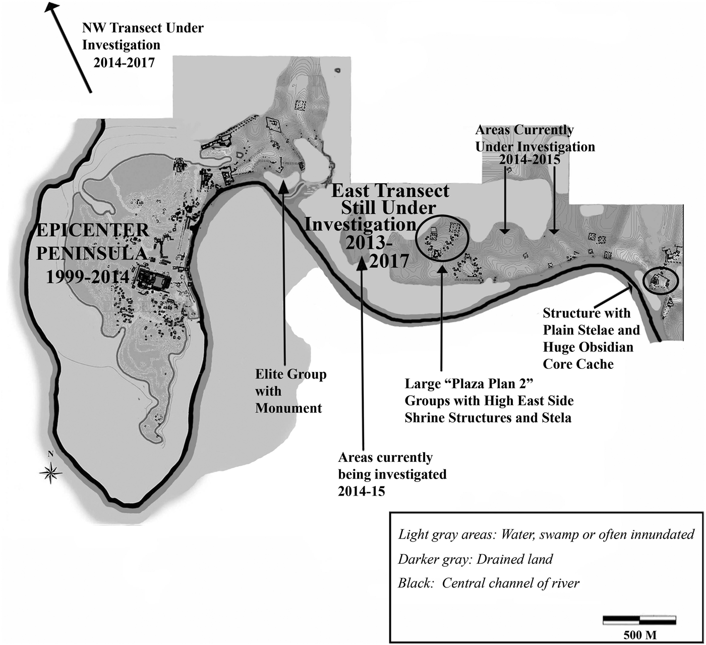
Part of “Greater Cancuen” showing peninsular epicenter, port area, and ongoing east transect leading into non-epicenter occupation (on high ground “mesetas” of drained land). Note the transect location of stelae/altar complexes, Peten architecture, ceremonial areas, and giant lithic cache. Maps by Marc Wolf and Justin Bracken.
CANCUEN HISTORY AND THE EIGHTH-CENTURY APOGEE
Using this strategic position, Cancuen became a rich royal capital. We know from multiple inscriptions that the Upper Pasión Cancuen kingdom had its earlier dynastic seat (not yet identified) moved by the hegemonic super power Calakmul to Cancuen's Late Classic period peninsular location (Figures 4, 5, and 7) at the head of navigation (Fahsen et al. Reference Fahsen, Demarest, Luin, Laporte, Suasnávar and Arroyo2003; Fahsen and Jackson Reference Fahsen, Jackson, Demarest and Barrientos2001). This founding occurred at a.d. 656, the same time that Calakmul engaged in other wars and alliances to take control of the Pasión river and the connecting land route north (Figure 5) (Canuto and Barrientos Reference Canuto and Barrientos2013; Demarest Reference Demarest2006; Freidel et al. Reference Freidel, Escobedo, Guenter, Sabloff and Fash2007; Martin and Grube Reference Martin and Grube2008). Cancuen's wealth, disproportionate to its site size, grew in the eighth century, as it progressed from a vassal of Calakmul, then to a part of the Dos Pilas hegemony, and then—with the a.d. 761 destruction of Dos Pilas—an independent power for the late eighth century. Over the short 144 years of the site's history there were great changes in material culture, well dated by monuments, architectural sequences, and ceramic microchronology.
By the mid-eighth century, and probably earlier, the Cancuen epicenter peninsula was filled with public and residential architecture, including its oversized palace, ports, noble's complexes, one workshop, and numerous nonelite residences of workers and staff, many possibly involved in port functions (see below). Beyond the ports and epicenter of the narrow peninsula, we now know that the Cancuen sustaining area occupation covers a large area with architecture extending for at least the 4 km east of the epicenter peninsula investigated thus far (Demarest Reference Demarest2013; Demarest et al. Reference Demarest, Martínez, Torres, Urquizu, O'Mansky, Wolf, Saravia, Cifuentes, Coji, Andrieu, Saravia, Luin, Tuyuc, Bracken, Arroyo, Salinas and Aragón2013; Demarest and Martínez Reference Demarest and Martínez2013; Spenard Reference Spenard2006; Urquizú et al. Reference Urquizú, Cifuentes, Nij, Demarest and Martínez2013; and see Wolf and Bracken Reference Wolf, Bracken, Demarest and Martínez2013a for data, definition, and discussion of the Cancuen complete site sustaining area and settlement). Due to 1999–2011 landowner restrictions, most discussion here (and most published to date) is on the peninsular epicenter and ports, the economic engine of the site.
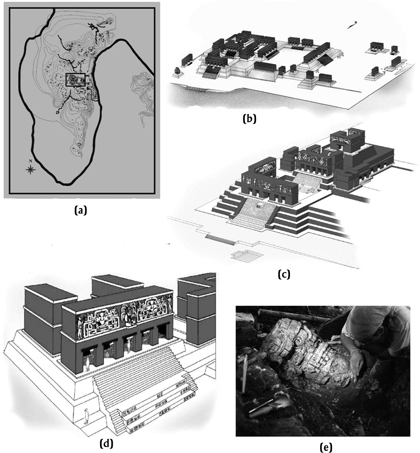
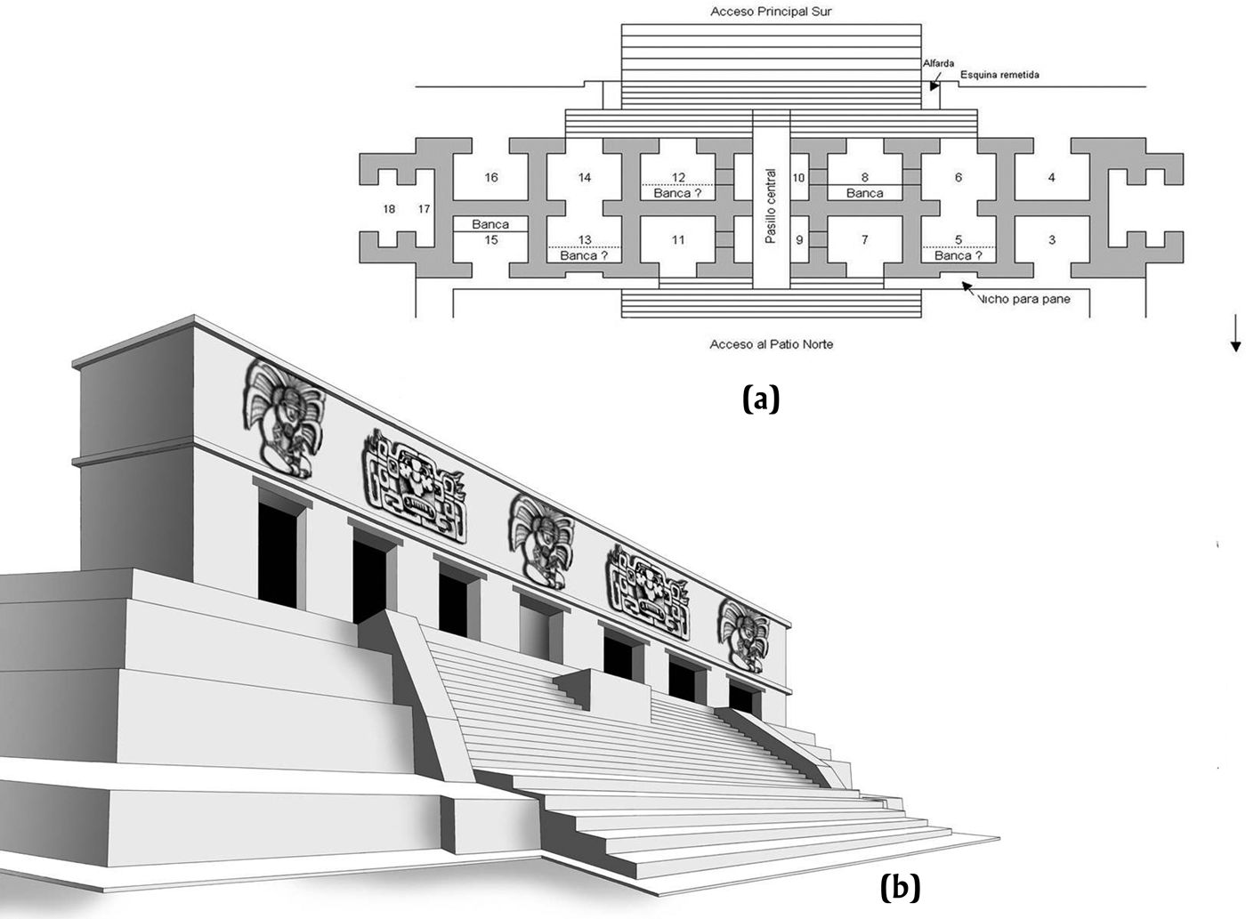
Cancuen's eighth century wealth was reflected in its ostentatious royal palace of over 32,000 m2. This palace featured 11 courtyards (Figure 8), with some rooms 8 m high and decorated with massive full round stucco sculptures, some reaching nearly 3 m in height (Barrientos Reference Barrientos2014; Barrientos and Demarest Reference Barrientos, Demarest and Cabezas2012; Demarest Reference Demarest2013). The palace covered an area almost equal to the Tikal palace, the Central Acropolis, although Cancuen is only a fraction of Tikal's size. The epicenter has three elaborate ballcourts, each in a different regional style (Torres Reference Torres2011), eight smaller range structure complexes, and at least six ports, of which three are fully confirmed and excavated. By the late eighth century, Cancuen had an interregional mix of styles in ceramics, architecture, and artifacts. The reach of its connections across Mesoamerica was extraordinary, as indicated by compositional (INAA) tracing of ceramics and sourcing of obsidian and jade (Andrieu, Quiñonez, and Rodas Reference Andrieu, Quiñonez and Rodas2010, Reference Andrieu, Quiñonez, Rodas, Demarest, Martínez, Quintanilla and Torres2011; Andrieu et al. Reference Andrieu, Quiñonez, Rodas, Demarest, Martínez, Quintanilla and Torres2011; Bishop et al. Reference Bishop, Sears and Blackman2005; Ronald Bishop, personal communication 2011–2013; Forné et al. Reference Forné, Alvarado, Torres, Belches, Demarest, Martínez, Forné, Quintanilla and Luin2008, Reference Forné, Demarest, Martínez, Torres, Alvarado, Arriaza, Laporte, Arroyo and Mejía2009, Reference Forné, Bishop, Demarest, Blackman, Sears, Arroyo, Aragón, Palma and Arroyave2010, Reference Forné, Andrieu, Demarest, Torres, Quintanilla, Bishop, Riveron, Arnauld and Breton2013).
Cancuen's central palace: (a) map position of the royal palace of Taj Chan Ahk showing its oversized placement in relation to the epicenter; (b) the Cancuen palace general view; (c) the western royal entryway; (d) one of the many high ostentatious exterior structures of the palace; (e) head of large stucco sculpture figure. All drawings by Luis F. Luin.
In light of its position and ports, this impressive late apogee is not surprising, since a good portion of the exotic goods necessary to many western Peten k'uhul ajaw for accoutrements of power or for patronage networks, would have passed through Cancuen—either along the north-south route of the Verapaz valley to the Pasión River or along the east-west transversal. To the south, in the adjacent Verapaz highland and piedmont regions, are recently identified sources of jade (Andrieu et al. Reference Andrieu, Quiñonez and Rodas2010, Reference Andrieu, Quiñonez, Rodas, Demarest, Martínez, Quintanilla and Torres2011), as well as the core habitat of the quetzal bird that was valued for its plumage. Down the southern land valley route also came Pacific coastal shell and, most importantly, huge quantities of El Chayal obsidian. Other commodities may have followed a lesser distance on the transversal routes. Cancuen was truly a “gateway center,” but not fully in the same technical sense as defined by Hirth (Reference Hirth1978), since its exchange and influence patterns at the highland interface continued to be linear, not dendritic, as guided by the topography along the Verapaz Valley route, the east-west transversal, and on the river corridor of the Pasión.
Cancuen's wealth, internationalism, and importance grew in three stages, as reflected by changes in alliances and trade routes, and as well defined by epigraphy, architecture, and ceramics. First, it was a modest kingdom under Calakmul domination (a.d. 656 to approximately a.d. 720). Then, between a.d. 720 and 735, it fell under the hegemonic sway of the Petexbatun kingdom. That connection was formalized by a much celebrated marriage alliance between the “Lady of Cancuen” and the ruler of Dos Pilas (Demarest Reference Demarest2006; Fahsen et al. Reference Fahsen, Demarest, Luin, Laporte, Suasnávar and Arroyo2003; Houston Reference Houston1993). Yet the periods of Cancuen's greatest internationalism and wealth corresponded with the late eighth century and a distinct change in strategy confirmed by artifacts and epigraphy. The a.d. 740–760 disintegration of the Petexbatun kingdom of Dos Pilas, the coeval defeat of El Peru-Waka, and other events led to an epoch of endemic warfare and political disintegration downriver to the north in the Middle Pasión region (Demarest Reference Demarest, Demarest, Rice and Rice2004, Reference Demarest2006; O'Mansky and Dunning Reference O'Mansky, Dunning, Demarest, Rice and Rice2004). As a result, much of the Pasión would have become extremely problematic as a route of transport. During the same period, the Usumacinta route, to which the Pasión connected, was also plagued with intercenter warfare, and there alternative routes and detours were sought by land and controlled by defensible outposts (Golden and Scherer Reference Golden and Scherer2013; Golden et al. Reference Golden, Scherer, Vásquez, Arroyave, Meléndez, Pérez, Quiroa, Marzahn-Ramos, Laporte, Arroyo and Mejía2007, Reference Golden, Scherer, Muñoz and Vásquez2008, Reference Golden, Scherer, Arroyave, Kingsley, Gillot, Piedrasanta, Valle, Arroyo, Palma and Aragón2010). It was precisely in that period, during the reign of the great ruler Taj Chan Ahk (a.d. 757–796), that Cancuen achieved its true apogee, the expansion of its palace, a proliferation of elite architecture, its finest ballcourts, massive obsidian exchange and production, very long-distance imports, and, in its final years (a.d. 790–800), a jade preform workshop. During these periods (relating to the Los Laureles [a.d. 760–780], Early Chaman [a.d. 780–790], and Late Chaman [a.d. 790–800] ceramic phases) (Forné, Alvarado, and Torres Reference Forné, Alvarado and Torres2011; Forné et al. Reference Forné, Bishop, Demarest, Blackman, Sears, Arroyo, Aragón, Palma and Arroyave2010, Reference Forné, Andrieu, Demarest, Torres, Quintanilla, Bishop, Riveron, Arnauld and Breton2013; Torres et al. Reference Torres, Orantes, Saravia, Tuyuc, Demarest and Martínez2013), there was an apparent change in Cancuen's exchange routes, avoiding the chaos of the Middle Pasión and Usumacinta to the north by emphasis on exchange along the east-west transversal route (Figures 1, 4, and 6), and marked by an influx of ceramics and some lithics from Tabasco and Veracruz. This “detour” west (Demarest et al. Reference Demarest, Woodfill, Barrientos, Fahsen, Monterroso, Laporte, Arroyo and Mejía2007, Reference Demarest, Martínez, Wolf, Torres, Belches, Andrieu, Luin, O'Mansky, Quintanilla, Laporte, Arroyo and Mejía2009) avoided the chaos occurring in the late eighth century to the north, where most of its former allies downriver on the Pasión were destroyed, declined, or were under siege (Demarest Reference Demarest2006; Inomata Reference Inomata2008; O'Mansky and Dunning Reference O'Mansky, Dunning, Demarest, Rice and Rice2004). A second change in emphasis was on the northeast river routes, moving not due north on the Pasión through the Petexbatun, but probably from the Upper Pasión to an eastern tributary river corridor to Machaquila (Figures 5 and 6)—a change indicated in historical texts at Cancuen (Fahsen and Barrientos Reference Fahsen, Barrientos, Barrientos, Demarest, Luin, Quintanilla and Mencos2006; Lacadena Reference Lacadena2011).
THE CANCUEN PORTS
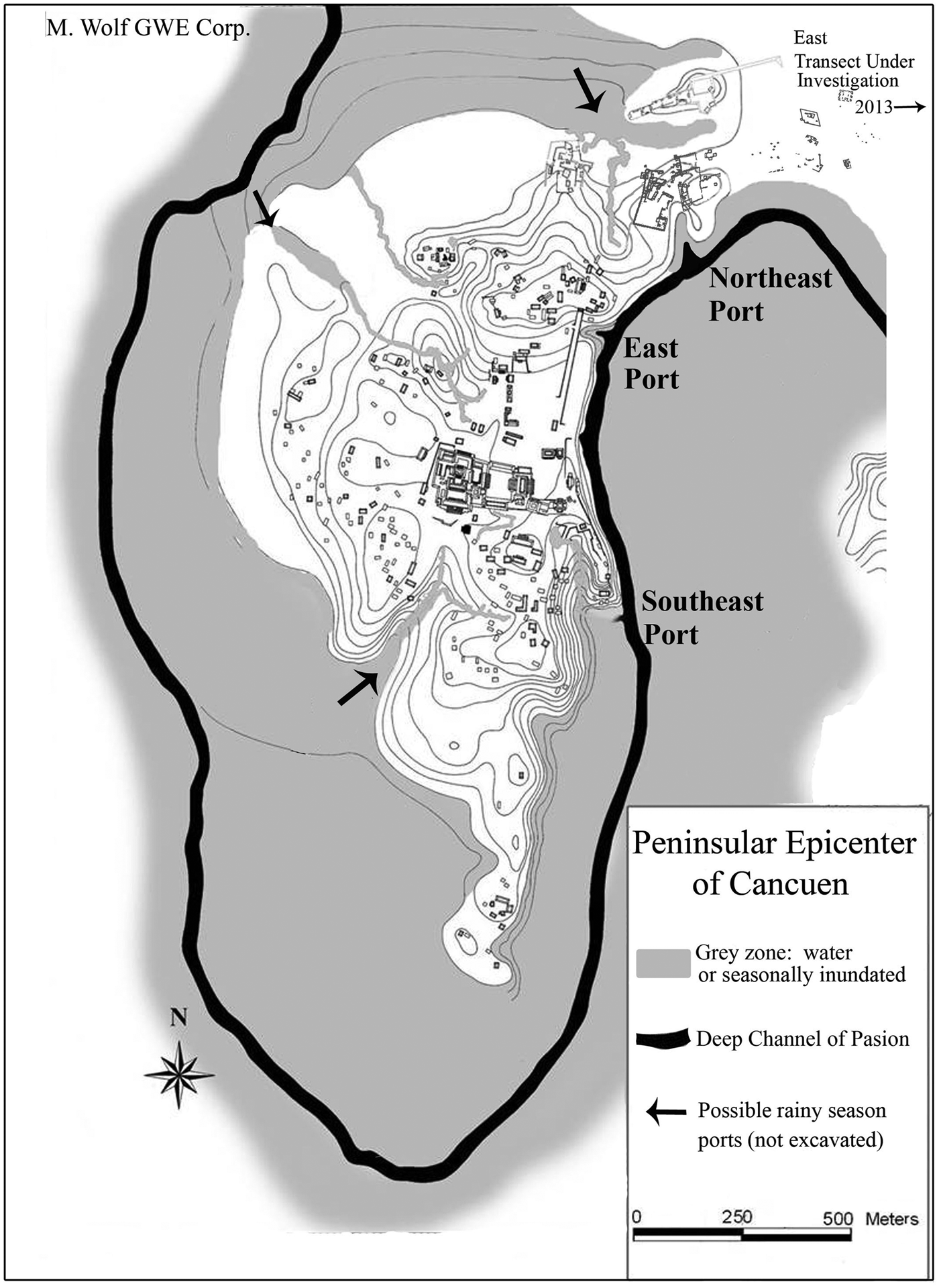
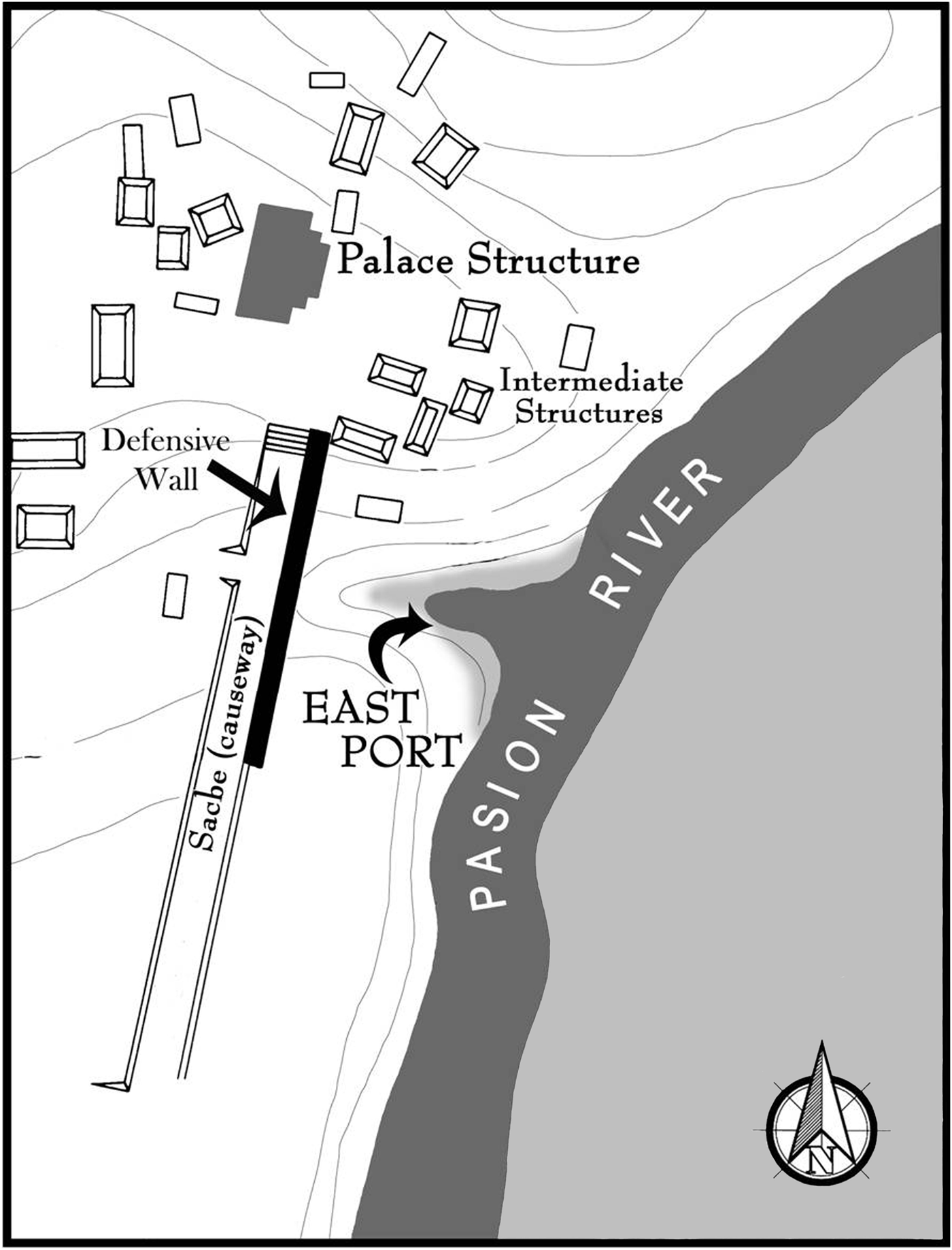
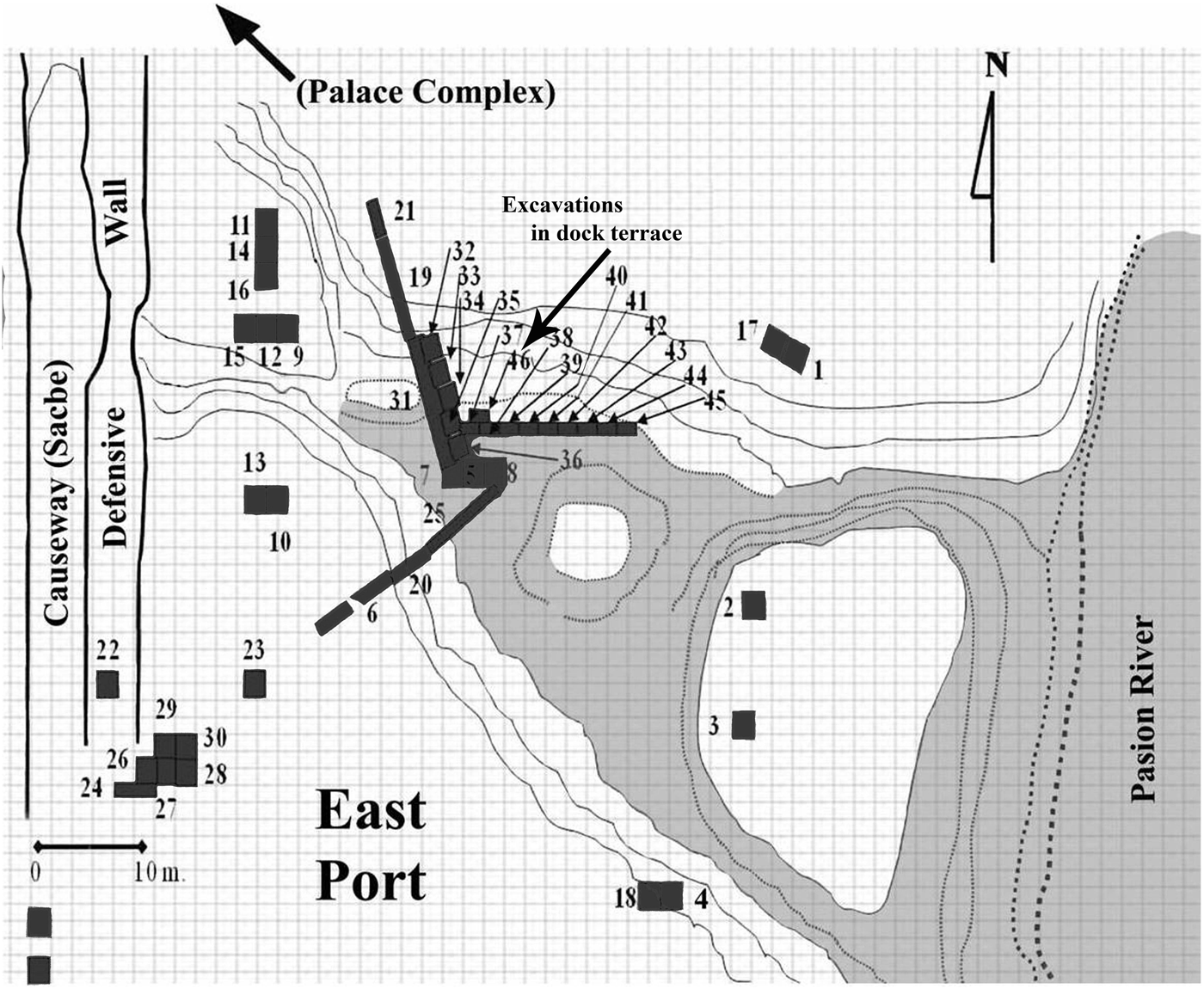
The peninsular epicenter of Cancuen was essentially a large port. By the mid-eighth century, probably earlier, it was filled with residential and public, elite and nonelite architecture, and its port facilities, which lined this peninsula, which was defined by the river and swamps (Figure 9). Based on topography and use today, there were six, possibly seven ports, with three or four of them on the western side of the peninsula. It is the three east side ports, however, that have been mapped in detail and extensively excavated between 1999 and 2013 (Alvarado Reference Alvarado, Demarest, Barrientos, Kovacevich, Callaghan, Woodfill and Luin2004, Alvarado et al. Reference Alvarado, Berryman, Novotny, Demarest, Barrientos, Demarest, Quintanilla and Luin2006; Demarest and Martínez Reference Demarest and Martínez2010, Demarest et al. Reference Demarest, Martínez, Forné, Quintanilla and Luin2008a, Reference Demarest, Wolf, Martínez, Valle, Barrientos, Quiñones, Rodas, Luin, Ajin, Arroyo, Aragón, Palma and Arroyave2011; Wolf and Bracken Reference Wolf, Bracken, Demarest and Martínez2013a). Those three are shown in Figures 9 to 16. Each consists of a fine protected natural portage with adjacent elite architecture located above the port on the north. Each port is surrounded by structures of a wide variety of styles, sizes, possible levels of status or wealth, and differing interregional affiliations in artifacts and architectural style. At two ports we have excavated probable stone docking locations or terraces. All three east side ports were still used by the local Q'eqchi' and/or landowners when our first explorations were initiated in 1996. Of the three excavated ports, two of these, the east and southeast ports, gave access to the elite activity areas, palaces, plazas, and a sacbe. A third, the northeast port, was the true “head of navigation” of the Pasión River and a principal working port, probably the most important at the site.
Cancuen main peninsula with probable ports and position of confirmed and excavated northeast, east, and southeast ports. Map by Marc Wolf and Luis F. Luin.
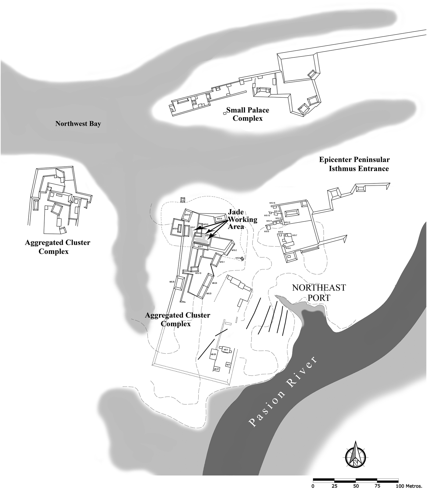
Complexes of the northeast including small palace, port areas, “aggregated cluster” complexes, and jade preform production area Maps by Marc Wolf and Justin Bracken.
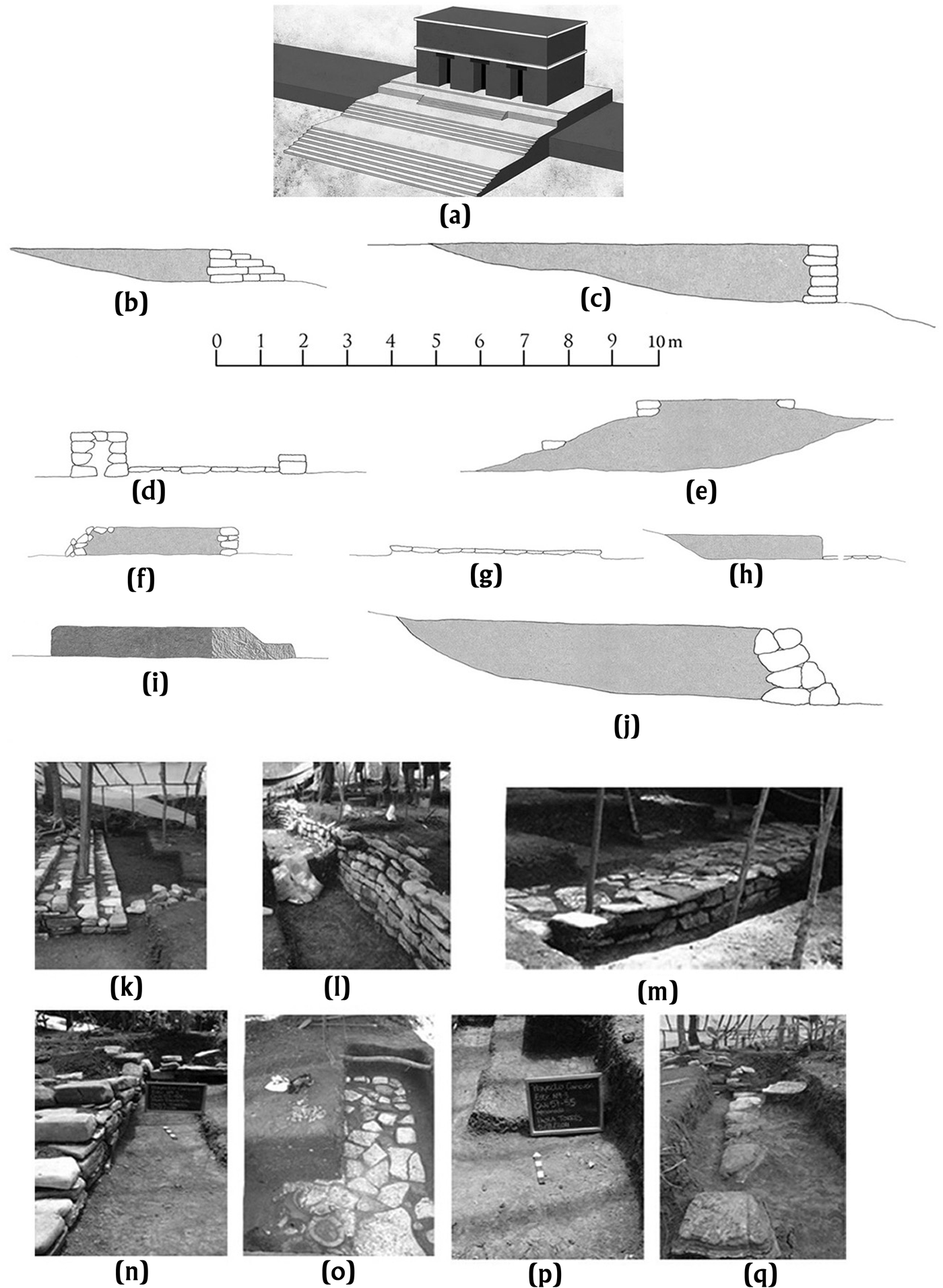
Some of the very wide range of different Cancuen architectural or construction styles on the level, and more often rolling, terrain of Cancuen: (a) fine masonry nonresidential audiencia range structure overlooking the northeast port and its varied groups; (b and k) artificially leveled ground with worked stone staircase; (c and l) partially worked stone terrace walls forming large leveled platforms; (d and m) structures with partially worked stone wall and patios of different heights; (e) higher mounds with platforms defined by lines of stone roughly worked on only one face; (f and n) platforms with unworked or minimally worked retaining walls; (g and o) very low platforms formed by thin unworked paving stones; (h) pounded clay platforms, some with thin flat stone patios; (i and p) platforms of very dense hard red clay, sometimes with later earth or clay extensions; (j and q) large unworked boulder retaining walls to level slopes for group or aggregated cluster construction.
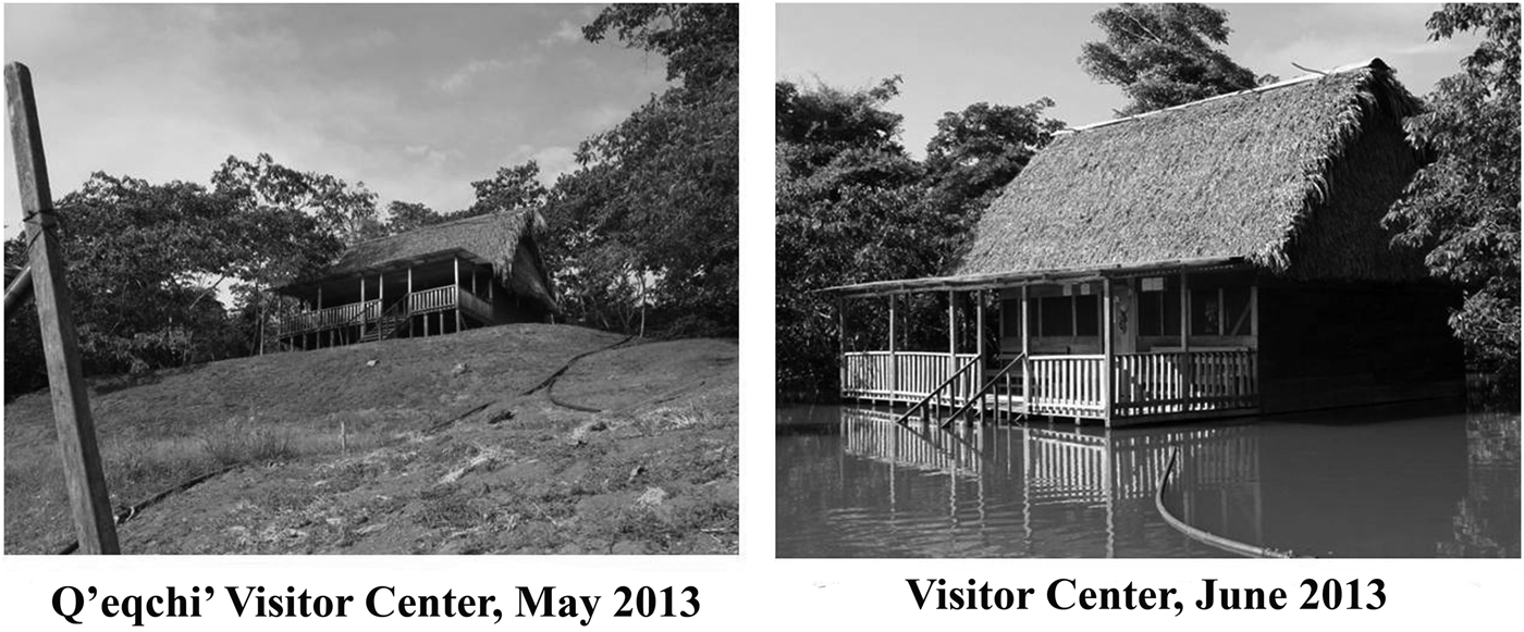
Examples of highly unstable river levels and frequent inundations (left, Q'eqchi' Maya Cancuen Visitor Center, May 2013; right, June 2013).
Map of east port. Map by Marc Wolf and Luis F. Luin.
Detailed map of excavations and features of Cancuen's east port. Map by Carlos Alvarado.
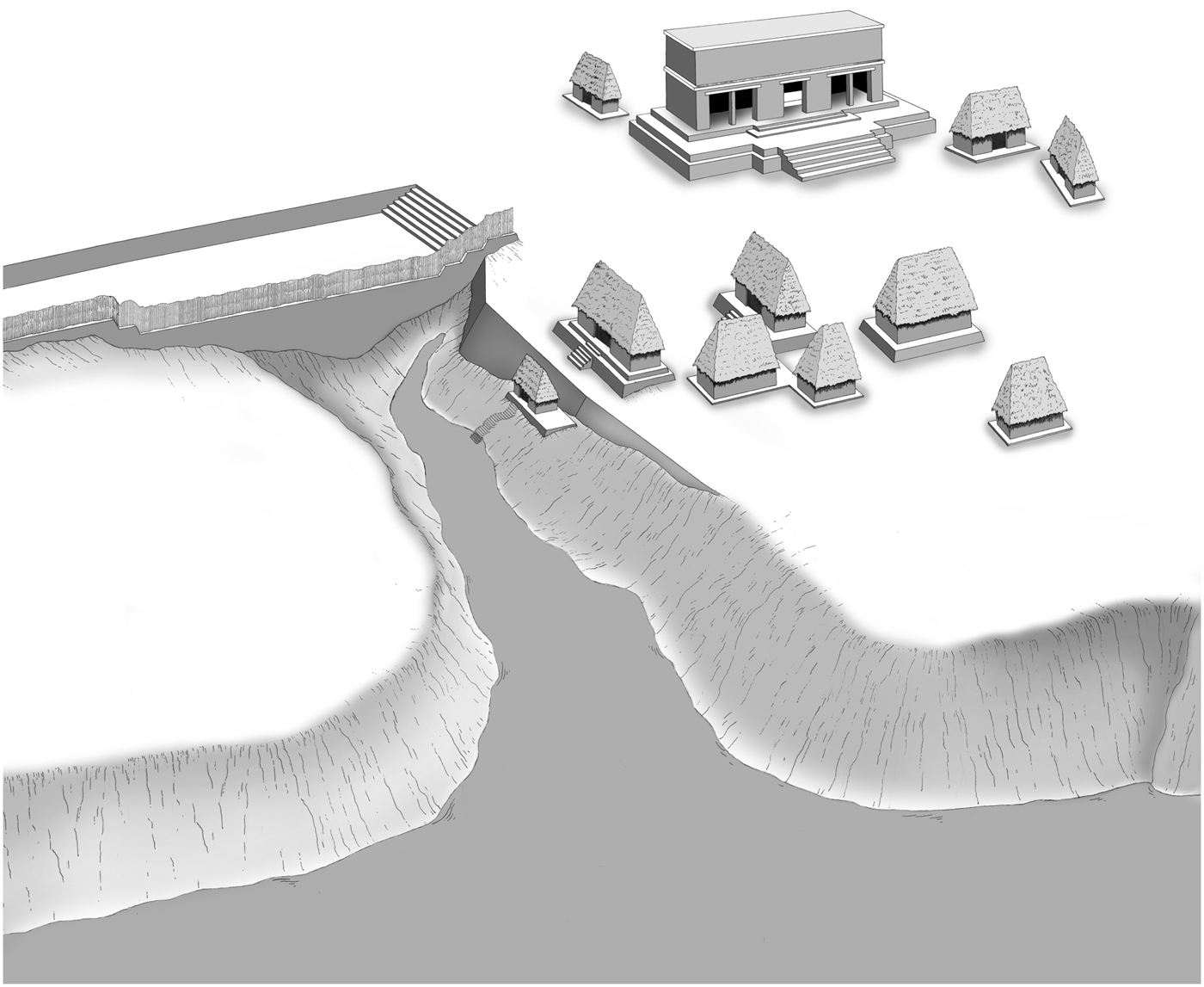
Reconstruction of the east port complex circa a.d. 800. Drawing by Luis F. Luin.
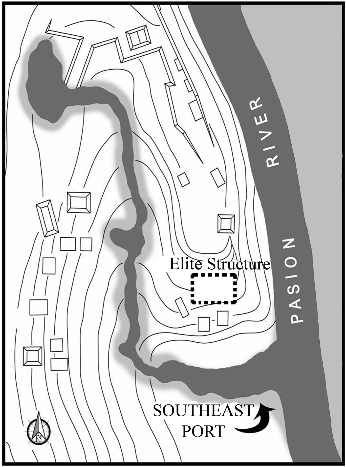
Map of the southeast port showing entrance, bay to epicenter, and dismantled elite structure. Map by Marc Wolf and Luis F. Luin.
Recent investigations (2008–2013) have focused on this northeast port zone (Figures 9, 10, and 11), which also linked to a wider, but more shallow, possible northwest port, the latter yet to be investigated. Located in the northern part of the epicenter peninsula, near this northeast port, were a high range structure complex, the jade preform working area, a number of unusual architectural complexes, and the isthmus entrance to the epicenter. The Peten-style range structure complex (Figures 10, 11a) dominates the landscape with an elaborate stairway and fine masonry and a higher percentage of Peten-style ceramics (Forné et al. Reference Forné, Bishop, Demarest, Blackman, Sears, Arroyo, Aragón, Palma and Arroyave2010, Reference Forné, Andrieu, Demarest, Torres, Quintanilla, Bishop, Riveron, Arnauld and Breton2013; Torres et al. Reference Torres, Orantes, Saravia, Tuyuc, Demarest and Martínez2013). It is situated on the north and at the highest point on the adjacent escarpment facing both the port and the jade preform workshop to the south. The slopes around the port present extremely uneven terrain, and so the hillside was sculpted by terraces for leveling (see, for example, Figures 10, 11j, and 11q), and many individual structure floors were made level by different types and styles of retaining walls on one, two, or three sides (Figure 11b, 11c, 11k, and 11l). Around the sides of the port, modified and artificial terraces rise up the steeply sloping escarpments south and north. A western path slopes more gradually from the port up the escarpment to the architectural complexes above.
On all sides of the area around the northeast port were structures of both probable residential and administrative function with a completely unpredictable range of styles and sizes (Figures 10 and 11). Many structures were clustered together in dense, irregularly shaped complexes incorporating platforms of differing style, and probable status and/or function, on high ground that was leveled or extended by artificial terraces (see Figure 11b, 11c, 11j, 11k, 11l, 11q). These are defined by Wolf and Bracken (Reference Wolf, Bracken, Demarest and Martínez2013a) as “aggregated clusters.” More than 30 structures have been identified near the northeast port and jade preform working mounds. Most of those structures were excavated with large horizontal exposures between 2006 and 2011 (Demarest et al. [eds.] Reference Demarest, Martínez and Luin2007, Reference Demarest, Martínez, Forné, Quintanilla and Luin2008, Reference Demarest, Martínez, Quantanilla and Torres2011; Demarest and Martínez Reference Demarest and Martínez2010; Wolf and Bracken Reference Wolf, Bracken, Demarest and Martínez2013a). Excavations measuring 2,796 m2 in this northern port and jade workshop zone have been carried out, as well as intensive laboratory analyses of all recovered artifacts and detailed mapping (Demarest et al. [eds.] Reference Demarest, Martínez and Luin2007, Reference Demarest, Martínez, Forné, Quintanilla and Luin2008, Reference Demarest, Martínez, Quantanilla and Torres2011; Demarest and Martínez Reference Demarest and Martínez2010; Wolf Reference Wolf, Barrientos, Demarest, Quintanilla and Luin2006; Wolf and Bracken Reference Wolf, Bracken, Demarest and Martínez2013a). As discussed above, structures there defy consistent typological assignment, some ranging from simple 4 × 6 m residential platforms, like typical Peten-style house mounds, to a fine masonry range structure, to a single platform of more than 270 m2 in area (9 × 30 m) with a six-course retaining wall only on its downhill slope and an obsidian and eccentric cache (Figures 10, 11c, and 11l). In yet other cases, structures are of cobbles and earth in highland style (Quiñonez and Hernandez Reference Quiñonez, Hernández, Demarest, Martínez, Quintanilla and Torres2011) (see Figure 11f and 11n), and still others have portions constructed in pounded clay (Figure 11i and 11p). Some are at ground level on one end but with retaining walls and even stairways on hill slopes (Figure 11b, 11c, 11k, and 11l). Middens and burials indicate that, whatever else their functions may have been, most were also residential. The complexity and variety of structures is primarily due to fitting them onto the rolling ridges between inundated and uninhabitable land that define parts of the peninsular epicenter, as well as most areas of the rest of Cancuen beyond it (Wolf and Bracken Reference Wolf, Bracken, Demarest and Martínez2013a). The variety, however, also probably reflects some specialized functions and, above all, the interregional variety at Cancuen in both structure styles and ceramics, which includes familiar Classic Maya Peten platforms, Dos Pilas-style construction (Figure 11e), and highland styles—with associated ceramics and lithics from the lowlands, the piedmont, the highlands, Tabasco, and Veracruz, as well as types distinctively characteristic of Cancuen assemblages.
The failure of most of our initial attempts at structure typologies and/or residential interpretations (Barrientos Reference Barrientos, Demarest, Barrientos, Kovacevich, Callaghan and Luin2002; Demarest et al. Reference Demarest, Barrientos, Kovacevich, Callaghan, Woodfill and Luin2003; Kovacevich Reference Kovacevich, Wells and Davis-Salazar2007, Reference Kovacevich, Hirth and Pillsbury2013; Woodfill et al. Reference Woodfill, Spenard, Barrientos, Kovacevich, Demarest and Barrientos2001) were due to the misapplication of standard lowland Maya categories to the bewildering variety of Cancuen's architecture, a variability most evident in the northern area of the epicenter and the non-epicenter east transect where level, drained land was limited. To understand Cancuen, particularly near the port areas, we find that it has been necessary simply to excavate extensively almost all structures with both deep trenches and wide horizontal exposures. The artifacts and architecture recovered have confirmed the strikingly multiregional nature of the city—fitting well with its port function as a nexus of exchange between many areas (Barrientos and Demarest Reference Barrientos, Demarest, Laporte, Arroyo and Mejía2007; Barrientos et al. Reference Barrientos, Demarest, Luin, Quintanilla and Mencos2006; Demarest et al. Reference Demarest, Martínez, Wolf, Torres, Belches, Andrieu, Luin, O'Mansky, Quintanilla, Laporte, Arroyo and Mejía2009, Reference Demarest, Martínez, Torres, Urquizu, O'Mansky, Wolf, Saravia, Cifuentes, Coji, Andrieu, Saravia, Luin, Tuyuc, Bracken, Arroyo, Salinas and Aragón2013; Forné et al. Reference Forné, Demarest, Martínez, Torres, Alvarado, Arriaza, Laporte, Arroyo and Mejía2009, Reference Forné, Bishop, Demarest, Blackman, Sears, Arroyo, Aragón, Palma and Arroyave2010).
Again, despite their great variability, most structures were, at least in part, residential, given middens and burials placed under floors or on one or more sides. Yet many structures appear to have had exclusively ritual or public functions (Barrientos Reference Barrientos2014; Demarest Reference Demarest2013; Torres Reference Torres2011). Judging from architecture and artifacts, status at Cancuen and some other Pasión sites (see, for example, Palka Reference Palka1995) was related directly to elevation and drainage in this swampy inundated zone. Lying near the base of the rainy Verapaz highlands, river flood levels at Cancuen can change erratically by 8–9 m per year and as much as 6 m in a single day, as occurred in June 2013 (Figure 12). In this swampy riverine peninsula, even minor differences in the elevation of residences and public architecture were consistently associated with higher levels of wealth or status, as seen in other archaeological markers (lithics, ceramics, masonry, etc.). Although this is not an uncommon pattern at Classic Maya sites, it is more pronounced here, given the river and swamp environment of Cancuen (see similar patterns at Dos Pilas [Palka Reference Palka1995] and La Joyanca [Arnauld et al. Reference Arnauld, Breuil-Martínez and Ponciano2004]). Note also that the slightly higher elevated ground usually has the longest occupation sequences within the ceramic phases of Cancuen's century and a half history (Arriaza Reference Arriaza2012; Barrientos Reference Barrientos2014). Completed and ongoing investigations of the general site sustaining area beyond the peninsula also reflect this association between elevation and status (Demarest et al. Reference Demarest, Martínez, Torres, Urquizu, O'Mansky, Wolf, Saravia, Cifuentes, Coji, Andrieu, Saravia, Luin, Tuyuc, Bracken, Arroyo, Salinas and Aragón2013; Wolf and Bracken Reference Wolf, Bracken, Demarest and Martínez2013a). At the lowest area of one mound cluster in the northern peninsula zone were several residential floors with almost no platforms, where initial stages of jade preform production were carried out near the end of Cancuen's history (Figure 10; see also Andrieu et al. Reference Andrieu, Rodas and Luin2014:Figure 2).
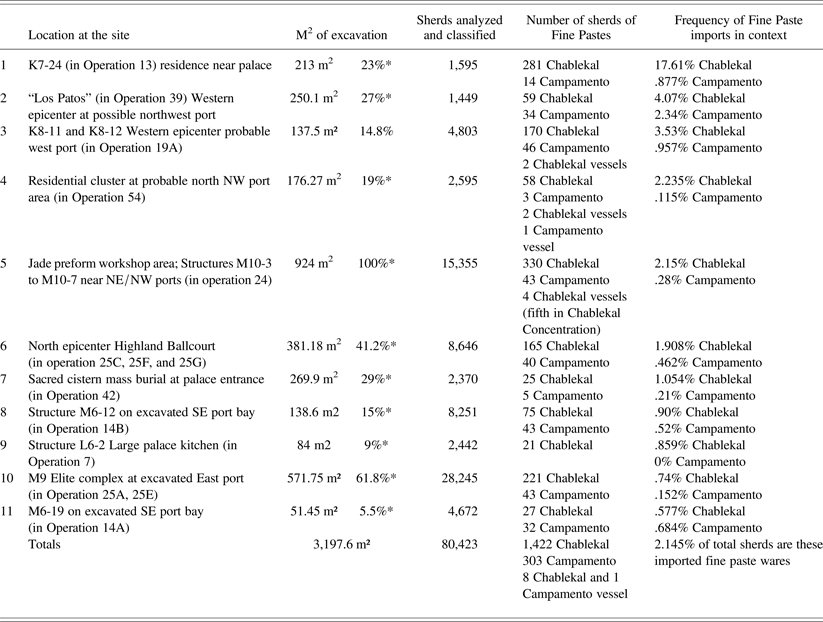
Further south, the east port (Figures 13, 14, and 15) is also well defined with a larger subroyal elite (“noble's”) palace complex directly above the sharply defined bay of the port. This port was excavated from 2002–2004 (Alvarado Reference Alvarado, Demarest, Barrientos, Kovacevich, Callaghan, Woodfill and Luin2004; Alvarado et al. Reference Alvarado, Berryman, Novotny, Demarest, Barrientos, Demarest, Quintanilla and Luin2006). It has a shallow small bay with one cobblestone terrace on the north side, just above water level, that could have served as a dock (Alvarado Reference Alvarado, Demarest, Barrientos, Kovacevich, Callaghan, Woodfill and Luin2004; Alvarado et al. Reference Alvarado, Berryman, Novotny, Demarest, Barrientos, Demarest, Quintanilla and Luin2006). At the end of the small port bay, the inclined slope leads up to a palace group and a stone, gravel, and plaster sacbe, which runs past courtyards and architecture further south toward the palace complexes (Figures 13 and 15). This port complex was surrounded in the final years of Cancuen's occupation by a defensive wall, identical to the many kilometers of such walls in the Middle Pasión Petexbatun region during its late eighth-century collapse period (Demarest Reference Demarest2006; Inomata Reference Inomata2008). The noble's complex directly above the port had numerous residential structures associated with a presentation palace structure of fine corbelled-vaulted masonry (Jackson Reference Jackson, Demarest and Barrientos2001, Reference Jackson, Demarest, Barrientos, Kovacevich, Callaghan and Luin2002, Reference Jackson, Laporte, Arroyo, Escobedo and Mejía2004, Reference Jackson2005). The fine masonry, purely Peten Maya-style principal structure has been identified to have been an audience chamber, as proposed by Barrientos (Reference Barrientos2014) for this and many peripheral structures of the palace—not residential, as originally conceived (Demarest et al. [eds.] Reference Demarest, Barrientos, Kovacevich, Callaghan and Luin2002, Reference Demarest, Barrientos, Kovacevich, Callaghan, Woodfill and Luin2003; Jackson Reference Jackson, Demarest, Barrientos, Kovacevich, Callaghan and Luin2002). The adjacent platforms of this plaza group, low but with well-defined retaining walls and high elevation, were the actual residences of the elites of this complex, and lower platforms nearby were likely those of retainers. Some of these well-constructed residential platforms had significant numbers of sherds of fine paste wares from Tabasco (Torres et al. Reference Torres, Orantes, Saravia, Tuyuc, Demarest and Martínez2013) (see Table 1). Note that an elaboration of this complex and a slight reorientation toward the port occurs in the late eighth century, perhaps associated with the defensive additions.
Ceramic detail on Gulf Coast Fine Paste imports. The 11 contexts with the highest frequencies of Fine Paste ceramics from Tabasco and Veracruz. (Listed in order of highest frequencies of Chablekal Fine Grey.)
*Percentage of area excavated compared to area excavated at jade workshop/NW port (924 m²)—by far largest sampled area.
All ceramic and statistical data by Paola Torres, Melanie Forne, and their laboratory teams. (Imports compositionally confirmed by INAA by Bishop/Smithsonian.)
Note that:
1) All contexts are securely dated to Los Laureles (a.d. 760–780), Early Chaman (a.d. 780–790), and/or Late Chaman (a.d. 790–800).
2) Six or seven of the 11 contexts with most imported Gulf fine pastes are areas adjacent to confirmed (east) or probable (west) ports (but the latter are still under investigation).
3) There is no correlation of Chablekal (nor Campamento) with production areas or artisans.
4) The jade workshop area is not highest in Chablekal frequency, but fifth, and seventh in Veracruz Campamento.
5) Combining # 8 and # 11 the general SE port area would be second in Campamento.
6) Surprisingly, there is no correlation with regional architecture styles.
The southeast port (Figure 16) is topographically very clear but has been disturbed by modern activity. It is the principal portage today. There a bay of the Pasión River was overlooked from an escarpment by several structures. Unfortunately, the principal structure here was dismantled for stone by the local landowner. Its form and status (potentially “middle” to “high”) can be inferred from finished masonry base blocks and the landowner's great stack of stone masonry extracted from the building (observed during our initial visits to the site in 1996). Excavations in and around this structure recovered ceramics of each period but with an unusual concentration of fine orange sherds from Veracruz (Torres et al. Reference Torres, Orantes, Saravia, Tuyuc, Demarest and Martínez2013) (see Table 1). Along the sides of the shallow inner bay that was entered from the southeast port were a variety of structures ranging from simple mounds to complexes with bottom courses of fine masonry, one of which had another concentration of the imported fine paste wares. The bay leads into the site, narrowing and terminating near the entrance to the royal ballcourt of Taj Chan Ahk and adjacent subroyal palace structures.
“INTERNATIONALISM” AT CANCUEN IN THE EIGHTH CENTURY
Fitting with its role as an interregional port center, Cancuen has a mixture of regional styles in both architecture and artifacts. Multiregionalism at Cancuen, especially in the a.d. 740–800 period, includes architecture in central Peten style, some with fine masonry, including a number of central Peten style “Plaza Plan 2” groups with high east side structures (at least three of those are outside of the epicenter on the east transect). Also present are Dos Pilas/Pasión distinctive style structures with a mix of only some (often just one or two) fine masonry courses combined with clay and rough faced stone. One structure of this Dos Pilas style is even part of the palace complex (Sears Reference Sears, Barrientos, Kovacevich, Callaghan and Luin2002). More common are southern highland styles of constructions of clay- and cobble-faced platforms and, of course, simple earthen mounds (Figure 11). Note that at Cancuen structure forms do not correspond simply with status, but also with chronological period, terrain slope, and regional styles. Indeed, a seemly unimpressive structure that was in the distinctive and rather crude Dos Pilas “mixed style” (of clay and partly worked stone with only a few courses of masonry) held the tomb of a king (Sears Reference Sears, Barrientos, Kovacevich, Callaghan and Luin2002). As at the east port, other compounds sometimes have nonresidential fine masonry “audiencias” with separate corresponding elite residences and combined with probable simpler retainer structures in terraced clusters (Barrientos Reference Barrientos2014; Barrientos and Demarest Reference Barrientos, Demarest and Cabezas2012; Cotom-Nimatu and Quintanilla Reference Cotom-Nimatuj, Quintanilla, Demarest, Martínez, Quintanilla and Torres2011; Jackson Reference Jackson, Demarest and Barrientos2001, Reference Jackson, Demarest, Barrientos, Kovacevich, Callaghan and Luin2002, Reference Jackson, Laporte, Arroyo, Escobedo and Mejía2004, Reference Jackson2005; Martínez Reference Martínez, Demarest, Martínez, Forné, Quintanilla and Luin2008; Martínez et al. Reference Martínez, Cotom, Quintanilla, Demarest, Martínez, Quintanilla, Torres and Luin2012). There are a number of enigmatic structures of unusual dimensions, some in highland style (Demarest and Martínez Reference Demarest and Martínez2010; Demarest et al. [eds.] Reference Demarest, Martínez, Quantanilla and Torres2011; Quiñonez and Hernandez Reference Quiñonez, Hernández, Demarest, Martínez, Quintanilla and Torres2011). Two modally early La Concordia phase (beginning at a.d. 656) palace constructions from the first occupation of the site by the dynasty were actually made of adobe bricks (Barrientos Reference Barrientos2014). The latter is clearly a highland influence, and a parallel to the initial palace architecture of the similarly intrusive “frontier” Peten Maya elite occupation at Copan during the Early Classic establishment of that lowland dynasty (Bell et al. Reference Bell, Canuto and Sharer2004).
“Frontier” interaction with transversal, piedmont, and highland sites is primarily reflected within Cancuen itself, rather than at those presumably less complex centers, a pattern that challenges both intuitive expectations and more traditional notions of “frontiers” between “high civilization” and less complex societies (Demarest Reference Demarest2013; Demarest et al. Reference Demarest, Martínez, Torres, Urquizu, O'Mansky, Wolf, Saravia, Cifuentes, Coji, Andrieu, Saravia, Luin, Tuyuc, Bracken, Arroyo, Salinas and Aragón2013; Wolf and Bracken Reference Wolf, Bracken, Demarest and Martínez2013b; and, for a fuller critique of such boundary models see, for example, Schortman and Urban Reference Schortman and Urban1994, Reference Schortman, Urban, Nichols and Pool2012). Epicenter ceramics are also eclectic, including not only Cancuen's local styles, but Tepeu lowland ceramics, highland vessels, southern piedmont Verapaz-style ceramics, and fine paste pottery from distant Tabasco and Veracruz (Ronald Bishop, personal communication 2011–2013; Forné et al. Reference Forné, Alvarado, Torres, Belches, Demarest, Martínez, Forné, Quintanilla and Luin2008; Reference Forné, Bishop, Demarest, Blackman, Sears, Arroyo, Aragón, Palma and Arroyave2010, Reference Forné, Quintanilla, Barrios, Arroyo, Aragón and Arroyave2011, Reference Forné, Andrieu, Demarest, Torres, Quintanilla, Bishop, Riveron, Arnauld and Breton2013; Forné and Torres Reference Forné, Torres, Demarest and Martínez2010; Torres et al. Reference Torres, Orantes, Saravia, Tuyuc, Demarest and Martínez2013).
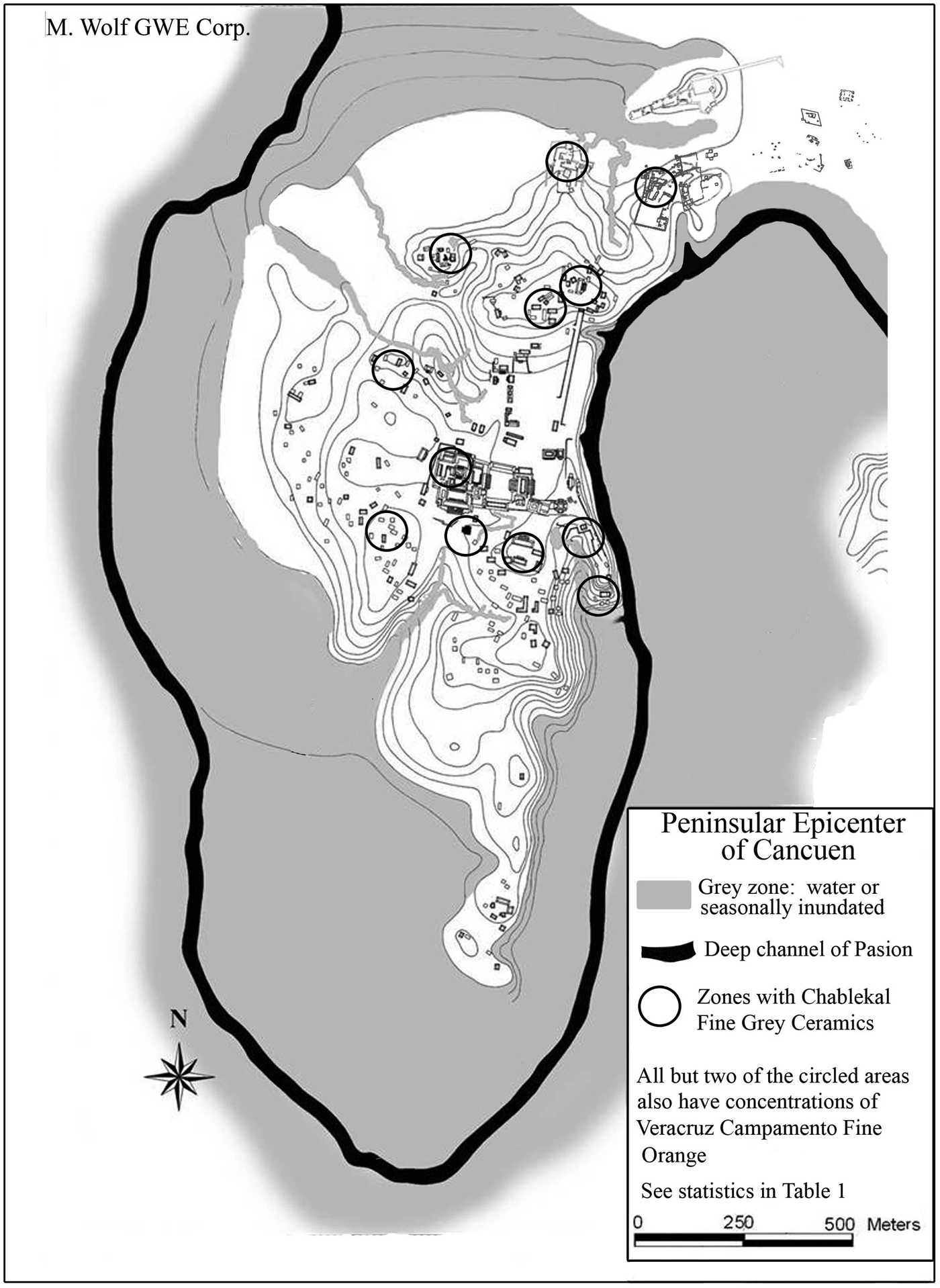
Using INAA data demonstrates that the high chromium variant Chablekal Fine Grey ceramics found at Cancuen (specifically the decorated Telchac Composite and Chicxulub Incised) were actual imports from the distant plains near the Gulf coast of Mexico, not just local stylistic imitations (Ronald Bishop, personal communication 2010–2013; Bishop et al. Reference Bishop, Sears and Blackman2005; Forné et al. Reference Forné, Bishop, Demarest, Blackman, Sears, Arroyo, Aragón, Palma and Arroyave2010). More recently, and even more surprising, was the compositional identification of Campamento Fine Orange ceramics imported from Veracruz (Ronald Bishop, personal communication 2010, 2012; Forné et al. Reference Forné, Bishop, Demarest, Blackman, Sears, Arroyo, Aragón, Palma and Arroyave2010, Reference Forné, Andrieu, Demarest, Torres, Quintanilla, Bishop, Riveron, Arnauld and Breton2013; Christopher Pool, personal communication 2011; Torres et al. Reference Torres, Orantes, Saravia, Tuyuc, Demarest and Martínez2013). It is important to emphasize that these thin-walled, fine paste wares of Chablekal and Campamento are not markers of the Terminal Classic period but are late eighth century ceramics (Chablekal a.d. 750–800; Campamento a.d. 650–800) that indicate early western exchange and influence of some kind (Bishop et al. Reference Bishop, Sears and Blackman2005; Forné et al. Reference Forné, Bishop, Demarest, Blackman, Sears, Arroyo, Aragón, Palma and Arroyave2010; Torres et al. Reference Torres, Orantes, Saravia, Tuyuc, Demarest and Martínez2013). These early fine paste wares are important in the establishing the culture-history, dating to the Los Laureles (a.d. 760–780) and Early Chaman (a.d. 780–790) and Late Chaman (a.d. 790–800) phases. Chablekal Fine Grey and Campamento Fine Orange ceramics are found at each of the three excavated ports and notably near the head of navigation northeast port but are also found in some deposits at other locations (Table 1; Figure 17). These loci include the elite residential complexes near the east port and the southeast port, groups near the northeast port, and at other structures near the palace and even a cache in the palace itself.
Distribution of some long-distance ceramic imports in the epicenter. Circles are areas of the epicenter that have Chablekal Fine Grey (high chromium variety) from Tabasco, some also having Campamento Fine Orange ceramics from Veracruz. Map and data by Paola Torres, Mélanie Forné, Marc Wolf, and Luis F. Luin.
Note that this ceramic type is not correlated with artisans, craftsmen, or jade production, as previously hypothesized (Demarest et al. [eds.] Reference Demarest, Barrientos, Kovacevich, Callaghan, Woodfill and Luin2003; Kovacevich Reference Kovacevich, Wells and Davis-Salazar2007, Reference Kovacevich, Hirth and Pillsbury2013), but with the entire northern port area, other ports, and other contexts but always associated with deposits or constructions dating to the late (a.d. 760–800) chronological periods, as now known from ten more years of site-wide investigations (Demarest et al. [eds.] Reference Demarest, Martínez, Forné, Quintanilla and Luin2008, Reference Demarest, Martínez, Quantanilla and Torres2011; Demarest and Martínez Reference Demarest and Martínez2010; Forné et al. Reference Forné, Bishop, Demarest, Blackman, Sears, Arroyo, Aragón, Palma and Arroyave2010, Reference Forné, Andrieu, Demarest, Torres, Quintanilla, Bishop, Riveron, Arnauld and Breton2013; Forné and Torres Reference Forné, Torres, Demarest and Martínez2010; Forné, Alvarado, and Torres Reference Forné, Alvarado and Torres2011; Torres et al. Reference Torres, Orantes, Saravia, Tuyuc, Demarest and Martínez2013) (see Table 1 for exact statistics; Figure 17 for a distribution map). There is no lithic working or production of any kind at most of the 11 identified areas with Chablekal concentrations (Torres et al. Reference Torres, Orantes, Saravia, Tuyuc, Demarest and Martínez2013) and it is not most associated with jade-working. Furthermore, we can no longer say that Chablekal is not associated with elites since many sherds were present in the east port noble's group and a lip-to-lip Chablekal dedicatory vessel cache was found in the patio directly in front of what has been identified as the very residential complexes of ruler Taj Chan Ahk (L7-12 and L7-33) within the palace itself (Barrientos Reference Barrientos2014; Barrientos et al. [eds.] Reference Barrientos, Demarest, Luin, Quintanilla and Mencos2006; Rodas et al. Reference Rodas, Toth, Steeves, Demarest, Martínez, Quintanilla and Torres2011; Torres et al. Reference Torres, Orantes, Saravia, Tuyuc, Demarest and Martínez2013; Valle Reference Valle, Demarest and Martínez2010). The latter is perhaps the most “elite” possible context in the site. Veracruz Campamento Fine Orange is relatively rare but co-varies with Chablekal and has its second greatest concentration at the two principal structures of the southeast port (Torres et al. Reference Torres, Orantes, Saravia, Tuyuc, Demarest and Martínez2013) (see Table 1 and Figure 17).
It seems probable, given their loci of distribution, that these fine paste ceramics had some significance, particularly associations with ports and long-distance exchange. But, even those correlations are not yet definitive. It is notable that two “aggregated cluster” groups near the northern ports also have such fine paste ceramics from Tabasco and Veracruz. One of these large complexes (Operation 24) contains a small group with jade preform production debris (Figure 10, center; see also Andrieu et al. Reference Andrieu, Rodas and Luin2014:Figure 2), but the other (Operation 54) (Figure 10, upper left) appears to be purely residential—with a variable mix of structures of different styles and probable statuses (Figure 11) within both of these aggregated clusters (Demarest et al. Reference Demarest, Martínez, Wolf, Torres, Belches, Andrieu, Luin, O'Mansky, Quintanilla, Laporte, Arroyo and Mejía2009, Reference Demarest, Martínez, Torres, Urquizu, O'Mansky, Wolf, Saravia, Cifuentes, Coji, Andrieu, Saravia, Luin, Tuyuc, Bracken, Arroyo, Salinas and Aragón2013; Torres et al. Reference Torres, Orantes, Saravia, Tuyuc, Demarest and Martínez2013; Wolf and Bracken Reference Wolf, Bracken, Demarest and Martínez2013a).
The multiregionalism of Cancuen is also manifest in the presence of both green and black opaque or semiopaque obsidian from highland Mexico in quantities (n = 201), much more than present at most Classic period Peten centers, and comparable to Terminal Classic occupations (Braswell Reference Braswell, Smith and Berdan2003; Forné et al. Reference Forné, Andrieu, Demarest, Torres, Quintanilla, Bishop, Riveron, Arnauld and Breton2013). This central Mexican obsidian is also mostly found in the northern portion of the peninsular epicenter and the northeast and east ports but, again, also in other locations, including the highland ballcourt. Of the Ixtepeque obsidian at Cancuen, all seven concentrations are at loci that have Chablekal Fine Grey ceramics. All of this material from distant regions speaks to the function of Cancuen as a transport center and also confirms that during the late eighth century (the epoch of downriver Pasión disintegration), Cancuen was not only looking south to the highlands, but was also engaged with the transversal land route to northern Chiapas, Tabasco, and Veracruz (Demarest et al. Reference Demarest, Martínez, Wolf, Torres, Belches, Andrieu, Luin, O'Mansky, Quintanilla, Laporte, Arroyo and Mejía2009, Forné et al. Reference Forné, Bishop, Demarest, Blackman, Sears, Arroyo, Aragón, Palma and Arroyave2010, Reference Forné, Andrieu, Demarest, Torres, Quintanilla, Bishop, Riveron, Arnauld and Breton2013; Forné and Torres Reference Forné, Torres, Demarest and Martínez2010).
Meanwhile, direct southern highland connections were apparent in ceramics and especially in the presence of a large sprawling highland-style ballcourt in the middle of the epicenter that is like none found in the Maya lowlands (Torres Reference Torres2011). Its low earthen alley was defined by alignments of natural stone slabs and it was surrounded by thick middens with local and Verapaz piedmont ceramics including comales, jars, and serving vessels (see Demarest Reference Demarest2013:Figure 9; Torres Reference Torres2011). It was a “feasting ballcourt” of the type found in the highlands and southern periphery of Mesoamerica (Fox Reference Fox1996), an identification confirmed by its artifactual associations with piedmont ceramics (Torres Reference Torres2011). It is particularly interesting to note that, while no such ballcourt is known in the lowlands, exactly this highland architectural style of ballcourt and other constructions is found at sites in the Verapaz/Quiche regions (Ichon and Hatch Reference Ichon and Hatch1982; Torres Reference Torres2011; van Akkeren Reference van Akkeren2012). This area is the source zone for Cancuen's substantial quantities of jade from the newly identified non-Motagua deposits (Andrieu et al. Reference Andrieu, Quiñonez and Rodas2010, Reference Andrieu, Quiñonez, Rodas, Demarest, Martínez, Quintanilla and Torres2011). As elsewhere, this underscores the economic as well as ritual functions of ballcourts (Fash and Fash Reference Fash, Fash, Wells and Davis-Salazar2007). It also is one of many elements indicating that Cancuen network connections with highland centers were built upon participation by highland and local leaders in rituals at Cancuen itself, rather than upon Cancuen military, or even economic, dominance (Demarest Reference Demarest2013; Demarest et al. Reference Demarest, Martínez, Torres, Urquizu, O'Mansky, Wolf, Saravia, Cifuentes, Coji, Andrieu, Saravia, Luin, Tuyuc, Bracken, Arroyo, Salinas and Aragón2013).
Additionally, while Cancuen in general lacks temples, its rituals were apparently more often held in the cave/hill shrines of remnant karst towers that lie a few kilometers from the greater site area, and 8–12 km from the epicenter peninsula (Demarest Reference Demarest2013; Demarest et al. Reference Demarest, Martínez, Torres, Urquizu, O'Mansky, Wolf, Saravia, Cifuentes, Coji, Andrieu, Saravia, Luin, Tuyuc, Bracken, Arroyo, Salinas and Aragón2013; Spenard Reference Spenard2006; Woodfill Reference Woodfill2010). The cave shrines there have very distinctive Cancuen ceramics, dominated by large open bowls and jars of the La Isla Group (Forné et al. Reference Forné, Demarest, Martínez, Torres, Alvarado, Arriaza, Laporte, Arroyo and Mejía2009, Reference Forné, Bishop, Demarest, Blackman, Sears, Arroyo, Aragón, Palma and Arroyave2010, Reference Forné, Andrieu, Demarest, Torres, Quintanilla, Bishop, Riveron, Arnauld and Breton2013; Forné and Torres Reference Forné, Torres, Demarest and Martínez2010; Torres et al. Reference Torres, Orantes, Saravia, Tuyuc, Demarest and Martínez2013). Beyond this area, however, the ceramic patterns of Cancuen end (Demarest et al. Reference Demarest, Martínez, Torres, Urquizu, O'Mansky, Wolf, Saravia, Cifuentes, Coji, Andrieu, Saravia, Luin, Tuyuc, Bracken, Arroyo, Salinas and Aragón2013). What is significant here is that, like the highland-style northern ballcourt, Cancuen's other religious rituals drew on highland canons, both within the site and in its sustaining areas (Demarest Reference Demarest2013; Demarest et al. Reference Demarest, Martínez, Torres, Urquizu, O'Mansky, Wolf, Saravia, Cifuentes, Coji, Andrieu, Saravia, Luin, Tuyuc, Bracken, Arroyo, Salinas and Aragón2013; Spenard Reference Spenard2006; Woodfill Reference Woodfill2010). All of these traits underscore the role of Cancuen as an exchange and port center.
NEW EVIDENCE ON CANCUEN OBSIDIAN, JADE, COMMODITIES, AND REGIONAL ECONOMY
As we have continued to investigate this very complex lowland/highland frontier center, repeated surprising discoveries have, accordingly, led to evolving perspectives on its economy. Recent data have demonstrated a much wider range of economic roles for this port city than previously imagined. These are now known to include not just the long-distance exchange of exotics, but also a large-scale involvement in commodity production and exchange on both a regional and interregional scale.
Obsidian Blade Production and Exchange
Obsidian is most often used as a trading indicator because it is not perishable and because, unlike many goods exchanged over great distances in the Maya lowlands, it is not a luxury good (Aoyama Reference Aoyama2001; Tourtellot and Sabloff Reference Tourtellot and Sabloff1972). As a major port in a strategic location between the highlands and the lowlands, Cancuen could have been a point for the transport of this material, especially the El Chayal obsidian that was primarily exchanged through inland routes during the Classic period (Arnauld Reference Arnauld1990; Hammond Reference Hammond1972, Reference Hammond and Renfrew1973; Nelson Reference Nelson1985, Reference Nelson, Puche and Olguín1994).
In fact, obsidian is abundant at the site. From 1999 to 2011, 11,862 fragments were recovered at Cancuen. From this material, the collection corresponding to the 1999–2004 excavations—which were originally analyzed with the data combined by structure types (Kovacevich Reference Kovacevich2006, Reference Kovacevich, Wells and Davis-Salazar2007)—has been entirely reanalyzed in order to be integrated into a lot by lot analysis, and then added to the rest of the materials from the later 2004–2011 excavations (Andrieu and Quiñonez Reference Andrieu, Quiñonez, Demarest and Martínez2010; Andrieu, Quiñonez, and Rodas Reference Andrieu, Quiñonez, Rodas, Demarest, Martínez, Quintanilla and Torres2011). Most of it could be visually associated to the El Chayal source (11,226 fragments), with 388 fragments visually attributed to the Ixtepeque source, 201 considered as non-Guatemalan (probably central Mexican, because of their visual aspect—opaque, green, or semiopaque), and 47 fragments attributed to other sources, such as San Martin Jilotepeque or Milpas Altas. X-ray diffraction is in course.
Most of the Cancuen production is oriented toward the manufacture of prismatic blades. Of the obsidian collected, 67% are prismatic blades, 0.8% are prismatic core fragments, 6.3% represent first and second series blades (Clark Reference Clark1997), and less than 3% represent core rejuvenation flakes. The overall lack of cortical fragments (n = 44), the scarcity of primary series blades, and the absence of any flakes corresponding to the preforming of the cores indicate that the material was brought into the epicenter as prepared cores (fragments considered ‘cortical’ were required to exhibit more than 50% cortex on a surface [Andrieu and Quiñonez Reference Andrieu, Quiñonez, Rodas, Demarest, Martínez, Quintanilla and Torres2011]). The remaining obsidian artifacts were composed of percussion flakes, a few flake tools (scrapers, macroblades, drills), bifacial industries, and small unclassified fragments.
When looking at the different sources of obsidian, it appears that not all this material was likely to have been managed the same way. The central Mexican and Ixtepeque obsidians are mostly associated with the northern part of the epicenter peninsula, implying that their exchange was probably not centralized. The low quantities of both these obsidian types could indicate that they were not exchanged as a principal import but that they arrived among other types of imports through long distance exchange networks. Such patterns would be consistent with the hypothesis of port activities, particularly in the northeastern area of the epicenter. A very different pattern appears, however, for the grey translucent obsidian that we have visually attributed to the El Chayal source. As a matter of fact, this obsidian material presents a much more centralized pattern. While the distribution of the prismatic blades is relatively homogeneous across the site (Andrieu Reference Andrieu2012), the distribution of prismatic cores is clearly centralized in elite contexts, indicating that this production could have been at least partially controlled. Of the 101 cores and core fragments found within the epicenter, 58 were found in elite ritual deposits: 53 in the burial of Kaan Maax, the last king of the site, two under an epicenter stela along with hundreds of obsidian flakes (Andrieu Reference Andrieu, Arroyo, Palma and Aragón2011, Reference Andrieu2012), and three in an elite burial in the adjacent small palace group (Operation 45B).
This pattern is reinforced by the recent discovery of a massive cache of prismatic cores. To the east of the peninsula, the site has continuous habitation on the areas of drained land with 123 structures mapped and/or tested, thus far, in the 4-km east transect alone, despite the fact that about 20% of this area has been leveled by tractor plowing and more than 40% of this area is uninhabitable swamp and steep slopes, and is frequently and erratically inundated. These transect structures include houses, standard plaza groups, “Plaza Plan 2” groups characteristic of the central Peten, “aggregate cluster” complexes, and elite or public architecture, such as higher structures (4–5 m tall), and three plain stelae groups. Near the end of the east transect, at 3.8 km from the epicenter peninsula, one plain stela was removed and revealed a cache of 4,219 chert flakes, 8 chert eccentrics, 8 obsidian eccentrics, and, most importantly, 831 whole spent or half spent obsidian cores and 20 complete, but broken, cores (Figure 18) (Urquizú et al. Reference Urquizú, Cifuentes, Nij, Demarest and Martínez2013). This is by far the largest obsidian core cache or burial deposit ever discovered in the Maya lowlands.
Some of the 851 whole spent (or half spent) obsidian cores from a Cancuen east transect stelae complex cache.
Together with core caches in elite or public contexts in the epicenter peninsula, this gives a total of 952 partially spent obsidian cores. If we add these to the ones found in the epicenter, it appears that 90% of the cores were concentrated in ritual or elite associated contexts. This implies that, at some point, these cores were gathered from the various craftspeople to be buried in highly valued contexts. Therefore, it is both a claim for control and a centralization of the means of production. It is a very clear hint of a direct relationship between prismatic blade production and elite contexts.
But such a quantity of cores is also impressive when compared to the quantities of blades found at the site. Most cores in the epicenter itself correspond to the very latest occupation at Cancuen: the Kaan Maax burial and Early (a.d. 780–790) and Late (a.d. 790–800) Chaman phases. Outside of the epicenter, this plain stela cache can be less precisely dated but was within the a.d. 760–800 timeframe (Torres et al. Reference Torres, Orantes, Saravia, Tuyuc, Demarest and Martínez2013; Urquizu et al. Reference Urquizú, Cifuentes, Nij, Demarest and Martínez2013). This implies a very high intensity of exchange during that period. It is difficult to calculate the exact number of blades produced from polyhedral cores (Clark Reference Clark and Isaac1986), but we can suggest, given the size of the complete prismatic blades at the site (3.7–9.5 cm in length and .5–1.5 cm in width) and that of the exhausted cores (with diameters ranging from 1–2.5 cm), that it is reasonable to infer that a core produced roughly 50–100 blades (Andrieu Reference Andrieu, Bonardin, Hamon, Lauwers and Quilec2009a, Reference Andrieu2009b; Clark Reference Clark1988; Flenniken and Hirth Reference Flenniken, Hirth and Hirth2003:100; Fowler Reference Fowler1981). Therefore, 952 cores would correspond to the production of anywhere between 47,600 and 95,200 blades—that is to say, far more than what was found for the entire occupation sequence of Cancuen, where the actual collection, so far, totals 7,934 blades. Even if we take into account the fact that a few cores from the plain stela cache were not completely exhausted and apply a minimal core/blade ratio of 20, there would still be a vast number of blades missing from the site.
The question remains, then, where did these blades go? Initially, it would seem that Cancuen was engaged in long-distance export of obsidian in the form of finished blades, which would seem improbable given the fragility of blades and the great distance north, downriver on the Pasión, to any major Classic Maya site. Another hypothesis, perhaps more probable, is that blade distribution from Cancuen in the late eighth century was not downriver, but was southward, to nearby sites with a highland material culture in the far northern Verapaz and “transversal” piedmont region. This possibility would fit with other new evidence of Cancuen's intra-regional ritual and political involvement with the surrounding non-lowland Classic Maya Verapaz communities (Demarest Reference Demarest2013; Demarest et al. Reference Demarest, Martínez, Torres, Urquizu, O'Mansky, Wolf, Saravia, Cifuentes, Coji, Andrieu, Saravia, Luin, Tuyuc, Bracken, Arroyo, Salinas and Aragón2013; Torres Reference Torres2011).
A few obsidian nuclei in this transect cache deposit, however, are not completely spent (Figure 18). This evidence, the nexus position of Cancuen, and the ample Peten textual evidence for long-distance exchange both north and west suggest that Cancuen was also exporting whole or half-spent obsidian cores downriver to the Peten. Now we have indications of a probable massive scale of both long-distance obsidian exchange and regional blade production at Cancuen. This evidence is even more striking considering that 2013 (due to previous landowner and/or ‘drug lord’ issues) was the first season of extensive excavations in the greater site transects outside the epicenter peninsula. Cancuen may prove to be one of the most important centers for both obsidian production and transport in the lowlands—and probably the largest in the Late Classic period. Future excavations on the eastern transect of the site will seek to locate the workshops and provide a better understanding of obsidian production and exchange at Cancuen.
Elite Supervision of Jade Production
Another important element indicating that Cancuen was oriented toward long-distance exchanges is the jade workshop located close to the northeast port of the site (Figure 10). This workshop was associated with several low, modestly constructed residential mounds within a much larger aggregated cluster (Demarest and Martínez Reference Demarest and Martínez2010; Demarest et al. [eds.] Reference Demarest, Martínez, Forné, Quintanilla and Luin2008, Reference Demarest, Martínez, Quantanilla and Torres2011; Kovacevich and Pereira Reference Kovacevich, Pereira, Demarest, Barrientos, Kovacevich, Callaghan and Luin2002; Wolf and Bracken Reference Wolf, Bracken, Demarest and Martínez2013a) where 3,606 fragments of jade debitage were found. The production in that workshop did not involve skilled artistry (Andrieu et al. Reference Andrieu, Quiñonez, Rodas, Demarest, Martínez, Quintanilla and Torres2011, Reference Andrieu, Forné, Demarest, Wiesheu and Guzzy2012, Reference Andrieu, Rodas and Luin2014; Kovacevich Reference Kovacevich2006). Instead, the analysis of the material showed that the craftspeople were separating different qualities of jade and making beads and earflare preforms by percussion (Andrieu et al. Reference Andrieu, Rodas and Luin2014; Andrieu and Forné Reference Andrieu, Forné, Arroyo, Palma and Aragón2010; Andrieu et al. Reference Andrieu, Quiñonez, Rodas, Demarest, Martínez, Quintanilla and Torres2011; Andrieu, Quiñonez, and Rodas Reference Andrieu, Quiñonez, Rodas, Demarest, Martínez, Quintanilla and Torres2011; Kovacevich Reference Kovacevich2006).
Many indicators show that this production was elite-controlled (Andrieu et al. Reference Andrieu, Rodas and Luin2014), mostly because it clearly appears from the burials found in this workshop that these craftspeople were excluded from access to the jade objects they produced. The distribution of the different colors of jade within the site clearly shows that the palace area benefited from a priority of access to the brightest (and most valuable) green jade (Andrieu et al. Reference Andrieu, Rodas and Luin2014:Figure 19). The lack of highland ceramics in that specific residential group—whereas some highland-style vases were associated with elite and royal burials—(Barrientos Reference Barrientos2014; Barrientos et al. Reference Barrientos, Demarest, Luin, Quintanilla and Mencos2006) also indicates that raw material procurement may have been elite-managed and that the craftspeople did not handle the importation of raw materials themselves (Andrieu et al. Reference Andrieu, Rodas and Luin2014).
Panel 3 of Cancuen showing ruler Taj Chan Ahk as a water lord, but sharing the scene with sajal and aj-k'uhun nobles (panel size 58 × 67 cm). Photograph by Ken Garrett; drawing by Luis F. Luin.
Above all, the location of the workshop indicates potentially direct supervision of the work by elites. Indeed, the jade preform workshop is at the bottom of a low topographic bowl completely surrounded by a variety of structures in this larger terraced “cluster” group and with more elite architectural complexes nearby (Andrieu et al. Reference Andrieu, Rodas and Luin2014:Figure 2; (Demarest Reference Demarest, Arroyo, Aragón and Mejía2012; Demarest and Martínez Reference Demarest and Martínez2010; Demarest et al. [eds.] Reference Demarest, Martínez, Forné, Quintanilla and Luin2008) (see Figure 10). One structure above the jade working area was a 9 × 30 m platform, with a stone masonry retaining wall on its downside slope (Rodas and Quiñonez Reference Rodas, Quiñonez, Demarest and Martínez2010; Wolf and Bracken Reference Wolf, Bracken, Demarest and Martínez2013a) (Figure 11c and 11l). Complexes of mixed styles and masonry construction—some with stairways (see Figure 11b and 11k)—are higher in elevation than the adjacent jade working areas (Figure 10). To the north, a fine masonry range structure stands directly above all of these complexes and the port of which they were a part (Figure 11a). In sum, the jade working mounds are surrounded by more than 30 structures, including large masonry platforms, houses, structures of a variety of styles, and an elite range structure—all in the epicenter of a major regional royal capital (Demarest Reference Demarest, Arroyo, Aragón and Mejía2012; Demarest et al. Reference Demarest, Martínez, Wolf, Torres, Belches, Andrieu, Luin, O'Mansky, Quintanilla, Laporte, Arroyo and Mejía2009, Reference Demarest, Wolf, Martínez, Valle, Barrientos, Quiñones, Rodas, Luin, Ajin, Arroyo, Aragón, Palma and Arroyave2011). Given the physical layout alone, it would be impossible for anything to occur in that area without elite supervision. As with the ports, location evidence suggests such elite supervision of the residential locus of jade preform production. This does not indicate, of course, elite participation in the actual production process, which was repetitive and very labor intensive (Andrieu et al. Reference Andrieu, Rodas and Luin2014).
This jade preform production activity came toward the end of Cancuen's occupational sequence (a.d. 790–800). The workshop's residential floors and middens held 98.4% of identifiable sherds (n = 15,113) from the Late Chaman phase (a.d. 790–800) and only 1.6% (n = 242) from the ancient surface below one mound were Los Laureles phase (a.d. 760–780) based on stratigraphic microchronological analysis (Forné and Torres Reference Forné, Torres, Demarest and Martínez2010; Torres et al. Reference Torres, Orantes, Saravia, Tuyuc, Demarest and Martínez2013). The Cancuen chronology is also now bracketed by epigraphic dates (Fahsen and Barrientos Reference Fahsen, Barrientos, Demarest, Barrientos, Kovacevich, Callaghan, Woodfill and Luin2003, Reference Fahsen, Barrientos, Barrientos, Demarest, Luin, Quintanilla and Mencos2006; Fahsen et al. Reference Fahsen, Demarest, Luin, Laporte, Suasnávar and Arroyo2003; Fahsen and Jackson Reference Fahsen, Jackson, Demarest and Barrientos2001) and correlated with a six-stage architecture sequence (Barrientos Reference Barrientos2014) for the a.d. 656–800 period. Thus, the jade production contexts are very securely dated to the Late Chaman phase (a.d. 790–800). This demonstrates that the workshop did not exist until after many features to which it has previously been correlated in various interpretations (Andrieu et al. Reference Andrieu, Quiñonez, Rodas, Demarest, Martínez, Quintanilla and Torres2011; Demarest et al. Reference Demarest, Barrientos, Kovacevich, Callaghan, Woodfill and Luin2003; Kovacevich Reference Kovacevich, Wells and Davis-Salazar2007, Reference Kovacevich, Hirth and Pillsbury2013).
There is little evidence of later stages of jade production, other than the preforms of beads and earflares, and finished jade artifacts are very rare at Cancuen. There are only 14 figurines or pendants and 16 earflares found, thus far, across the entire site, and there is very little jade in burials—even noble and royal burials (Andrieu et al. Reference Andrieu, Rodas and Luin2014; Barrientos et al. Reference Barrientos, Demarest, Luin, Quintanilla and Mencos2006; Quintanilla Reference Quintanilla2013). Further, of the 14 somewhat more elaborately carved jade objects (the pendants), some predate the workshop. For example, two of these are diadem or crown pieces bearing the “X” design found on the Jester God's forehead that were recovered from a Dos Pilas architectural-style (single phase) shrine and royal tomb of the predecessor, probably the father, of Taj Chan Ahk (Barrientos Reference Barrientos2014; Sears Reference Sears, Barrientos, Kovacevich, Callaghan and Luin2002). This shrine has a carved panel celebrating the latter's accession to power, which took place in a.d. 757, a date that aligns well with the ceramics (modally transitional between the La Concordia and Los Laureles phases) and with the distinctive Dos Pilas architecture (a style that ends with the destruction of that site at a.d. 761). Barrientos (Reference Barrientos2014), from his architectural sequence (linked to epigraphic dedication dates), would date this even somewhat earlier, to a.d. 740–750. Thus, the tomb and shrine (K7-3), along with its fine jades, predate the jade workshop by somewhere between 30 to 50 years, as do many other important contexts. A second finely carved jade object is a carved plaque found in the throne cache in the palace and is, significantly, from the later period of the workshop, during the Late Chaman phase (a.d. 790–800). In the other 117 burials analyzed thus far, from any time period, including elite burials, less than a dozen have very simple carved jade objects (Andrieu et al. Reference Andrieu, Rodas and Luin2014; Quintanilla Reference Quintanilla2013). The rich deposit of offerings at the cistern sacrifice site, where 31 elites were executed and deposited with many precious artifacts, also has only a few jade pieces (n = 37), and all but four were simple beads (n = 33) (Andrieu et al. Reference Andrieu, Rodas and Luin2014; Barrientos et al. [eds.] Reference Barrientos, Demarest, Luin, Quintanilla and Mencos2006; Demarest et al. Reference Demarest, Quintanilla, Suasnavar, Iannone, Houk and Schwake2014; Quintanilla Reference Quintanilla2013).
This paucity of jade artifacts is remarkable for any intensively excavated dynastic epicenter, especially one with impressive elite and public architecture and monuments, and even more unexpected at a production site. The difference between the 4 kg of finished artifacts and the 60 kg of jade debitage found in the workshop is surprising. This, plus the lack of jade production waste that would have corresponded to an absent stage of bead and earflare production, suggests that preform production was almost exclusively as an export commodity (Andrieu and Forné Reference Andrieu, Forné, Arroyo, Palma and Aragón2010; Andrieu et al. Reference Andrieu, Forné, Demarest, Wiesheu and Guzzy2012, Reference Andrieu, Rodas and Luin2014).
Jade preform exchanges have never been previously documented in the Maya lowlands before, but they appear to be attested to later on for the Aztecs (Andrieu et al. Reference Andrieu, Rodas and Luin2014). Interestingly, we can underscore that the exchange of preform, rather than finished objects, implies a form of commodification of jade. Preforms are more standardized in form and shape, and they certainly do not imply the same obligations between the actors of the exchange than the gift of finely carved objects (Andrieu et al. Reference Andrieu, Rodas and Luin2014; for jade as a “commodity,” see also Freidel et al. Reference Freidel, Reese-Taylor, Mora-Marín, Masson and Freidel2002; Freidel and Reilly Reference Freidel, Reilly, Staller and Carrasco2010; Masson and Freidel Reference Masson, Freidel, Hirth and Pillsbury2013:28; Rochette Reference Rochette and Hirth2009, Reference Rochette2014).
Perishable Commodities
Other, perishable commodities were probably also traded to and from Cancuen. Recent ethnohistorical studies (Caso Barrera and Aliphat Fernández Reference Caso Barrera and Aliphat Fernández2006, Reference Caso Barrera and Fernández2012; van Akkeren Reference van Akkeren2012) show that the “transversal” piedmont zone, just 12–15 km to the south of Cancuen, was a major zone for production of cacao, cotton, achiote, and vanilla throughout the Contact period. Indeed, the cacao and achiote from this piedmont zone were considered to be of unusually prized quality (van Akkeren Reference van Akkeren2012:38–39). Paleobotanical studies are underway to try to identify physical evidence of cacao at transversal sites (Avendaño et al. Reference Avendaño, Morales and Aguilera2013). The highly valued Maya condiments of vanilla and achiote were mixed with the processed cacao in chocolate drinks (Caso Barrera and Aliphat Fernández Reference Caso Barrera and Aliphat Fernández2006:36–37; van Akkeren Reference van Akkeren2012:39), and, of course, cacao was a major element in tribute and court economy (McAnany Reference McAnany, Hirth and Pillsbury2013; McAnany et al. Reference McAnany, Thomas, Morandi, Peterson, Harrison, Masson and Freidel2002; Stuart Reference Stuart, Guernsey and Reilly2006). Cotton was also a major product of the “transversal” far northern Verapaz region (van Ahkeren Reference van Akkeren2012). Such transversal cotton would have been important to all the population, but cotton mantas were, specifically, given as tribute to Maya royal courts (McAnany Reference McAnany, Hirth and Pillsbury2013).
At Salinas de Nueve Cerros, further west on this same transversal route, previous and ongoing research (Dillon et al. Reference Dillon, Pope and Love1988; Woodfill et al. Reference Woodfill, Monterroso, Sears, Castillo, Garrido, Arroyo, Aragón, Palma and Arroyave2011, Reference Woodfill, Guenter and Monterroso2012) has demonstrated large-scale salt production of more than 24,000 tons a year. A major route of salt transport from Salinas would have been east on the piedmont transversal to the ports of Cancuen and then downriver via the Pasión. Distinctive Cancuen-style figurines have been found at Salinas and compositionally sourced by INAA to Cancuen (Sears et al. Reference Sears, Bishop, Blackman, Laporte, Arroyo and Mejía2005). Furthermore, a unique style of grinding stone for final salt processing has been identified at the salt mines of Salinas de los Nueve Cerros, and a number of such grinding stones have been found at Cancuen (Mijangos Reference Mijangos2013). Movement of other perishables may have also included quetzal feathers from the Verapaz core area, their “biotope,” which lies directly on the Alta Verapaz Valley route to Cancuen. Probable transfer of all of these perishables through the Cancuen ports is geographically the shortest and least difficult route. As always, for routes we must rely most directly on lithic and ceramic evidence, and the rest is difficult to demonstrate, but Cancuen was very likely to have been involved in local and regional, as well as long-distance, exchange.
ELITE AND NONELITE ECONOMIC ROLES AND POWER AT CANCUEN
What was the nature of economic activities and roles in the variety of complexes around the northern and other ports, and the jade production area? In this regard, it is probable that residential jade preform producers and other nonelites were probably not “full time” crafters. The quantities, though high for a material as precious as jade, do not correspond to full-time work; in fact, percussion work is the least time-consuming aspect of the working of jade (Pétrequin et al. Reference Pétrequin, Bontemps, Buthod-Ruffier, Le Maux, Pétrequin, Cassen, Errera, Klassen, Sheridan and Pétrequin2013). It requires strength but not time, as most fractures are immediate from the percussion. The same could be said for prismatic blade production, knowing that a qualified knapper can produce a complete polyhedral core in roughly an hour (Darras Reference Darras2010:29), and that “[w]orking at a relaxed pace, one competent knapper could reduce 160 polyedral cores in 50 days, working about 2–4 hour day” (Clark and Bryant Reference Clark and Bryant1997:132). Thus, the presence of 952 cores, though impressive and highly significant in terms of trade and exchange, would not imply more than a few months of part-time work, if it was made by a single knapper and even less if there were numerous artisans.
Few nonelites at the Cancuen epicenter peninsula itself would have been farmers, since by the late eighth century construction had covered all potential agricultural land on the peninsular core of the site. As discussed above (see also Demarest and Martínez Reference Demarest and Martínez2013; Wolf and Bracken Reference Wolf, Bracken, Demarest and Martínez2013a), moving eastward from the isthmus of the epicenter, less dense habitations and clustered groups continue for, at least, the 4 km from the peninsula investigated to date (Figure 7). The structures mapped on that transect so far would correspond to a density of about half of that in the peninsular epicenter. These areas, broken by water and swamp, and probably also extending in other directions, provided part of the agricultural sustaining area of the site. How the epicenter nonelite, nonagricultural workers identified themselves, given multiple occupations, is more problematic, but their power over the productive process might have been minimal when compared to the wide variety of craft and labor arrangements identified elsewhere in Mesoamerica (Brumfiel Reference Brumfiel, Costin and Wright1998; Costin and Wright Reference Costin and Rita1998; Hirth Reference Hirth1996, Reference Hirth and Hirth2009; Hirth [ed.] Reference Hirth2009; Hirth and Pillsbury Reference Hirth and Pillsbury2013; Inomata Reference Inomata, Hruby and Flad2007; Reents-Budet Reference Reents-Budet, Costin and Wright1998; Schortman and Urban Reference Schortman and Urban2004; Schortman et al. Reference Schortman, Urban and Ausec2001).
The probability is that many nonelite families and individuals in the epicenter peninsula area were involved in port functions—most “part-time” in any one occupation but being fully employed as retainers or workers for resident elites in one activity or another. The center would have needed masons, cooks, and servants. Above all, however, there would have been a great need for porters, boatmen, rowers, canoe builders, carpenters, and agents of various kinds for the primary function of epicentral Cancuen, which would have been transport, not production. Port and transport-related occupations are seldom discussed in the Maya area, except in terms of energetics, but any broader comparative consideration would indicate the great importance of such occupations in economy and identity, particularly at a port city. As an aside, modern Pasión River Q'eqchi' Maya boatmen have a highly respected, though generally nonelite, status. They are often the wealthiest members, of their, albeit not very wealthy, communities.
Note here that we would not extrapolate from the evidence for elite involvement in exchange and supervision on the Cancuen epicenter peninsula as a general model for Classic Maya centers. Cancuen's location, its access to multiple long-distance exchange routes, the channeling mechanism of its ports, its connections to Gulf coast economies, and the late date of its apogee, may all indicate an unusual economy and, as discussed below, one that was undergoing change near the end of the Classic period. Thus, the Cancuen port economy is best viewed as an addition to the growing body of evidence on the great degree of economic and political variability in the centers of the Classic Maya lowlands.
PORTS, MATRIX CONTROL, AND IDEOLOGY
The supervision of ports by elites, or even the state, could have provided ample opportunity for control of resources, elite accumulation, and the development of economic power. The strategic position of Cancuen on major exchange routes provided great opportunities to create regional and interregional mechanisms of control. On the Cancuen epicenter peninsula itself, restricted access of the ports and isthmus could have facilitated control of epicenter networks of distribution of a wide range of goods. That would provide ideal circumstances for what Hirth (Reference Hirth1996:224) identifies as the “matrix-control principle” in which elites “seek to control these networks by placing themselves at major matrix positions to influence directly or indirectly the production, accumulation, and flow of resources.” While the social constructs surrounding elite matrix-control of materials are not well defined at Cancuen, the opportunity for such control is clear. Matrix-control in this case would facilitate Hirth's (Reference Hirth1996:224) “context-oriented accumulation … where resources are produced and/or accumulated in special contexts under the direction of organizing or supervising elites.”
Yet elite control over peninsular ports and transferred material resources needed to be defined and legitimated. It is not a foregone conclusion that elites control specific resources. To define this it was necessary to have an economic ideology, as in Hirth's “ideology principle.” “An economic ideology reinforces both the basis for the unequal accumulation of resources and the structure in which it occurs” (Hirth Reference Hirth1996:225; also see DeMarrais et al. Reference DeMarrais, Castillo-Butters and Earle1996). In this case, control would be of ports and some material resources—an economic power that would need to be legitimated. Such mechanisms of legitimation and/or economic ideology at Cancuen are discussed in detail elsewhere (Barrientos et al. Reference Barrientos, Demarest, Luin, Quintanilla and Mencos2006; Barrientos and Demarest Reference Barrientos, Demarest and Cabezas2012; Demarest Reference Demarest2013). Just a glimpse of legitimating ideology might be seen in Cancuen's rich corpus of iconography and architecture. For example, in almost all representations, the ruler is identified as a water lord. Both the ruler, Taj Chan Ahk, and his highest nobles are presented (Figure 19) in a quatrefoil with water symbols, water lilies, and a water deity (Fahsen and Barrientos Reference Fahsen, Barrientos, Barrientos, Demarest, Luin, Quintanilla and Mencos2006). Elite architecture is covered with stucco imagery with water associations. The royal ballcourt where kings played nobles was covered with such stucco imagery with water symbols (Fernández Aguilar Reference Fernández and Enrique2010).
State or elite control over the river itself also may have been claimed in aspects of ritual site landscaping. Throughout the site epicenter runs an elaborate ritual water system, a miniature river with stone pools at springs, and small 1 m-wide channels (for more detailed discussion of this feature see Alvarado Reference Alvarado2011; Alvarado and Mencos Reference Alvarado, Mencos, Martínez, Demarest, Forné and Luin2007; Barrientos Reference Barrientos2008; Barrientos et al. Reference Barrientos, Demarest, Luin, Quintanilla and Mencos2006; Demarest Reference Demarest2013). This system is comparable to that at other sites but is purely ritual, and its symbolism might be more specific than elsewhere (Lucero and Fash Reference Lucero and Fash2006). The elaborately constructed water system was symbolic in nature, since the site has several springs within it, as well as being almost an island in the Pasión River with access to the last aerated cascades (compare against the situation at Copan: Fash Reference Fash, Andrews and Fash2005; Fash and Davis-Salazar Reference Fash, Davis-Salazar, Lucero and Fash2006). Water was always abundant, but the ritual water system may have further legitimated their control of the critical nodes in the site's economic matrix—the river and its ports. Other ideological devices may have been specific rituals, rather than architectonic (Demarest Reference Demarest2013).
A number of factors indicate a shift to possible control by nobles of the ports in the final half-century of Cancuen's history. What is most obvious is the layout of all three of the most investigated ports, as discussed above. Each port was also surrounded by a variety of other elite and “intermediate range” unusual architectural complexes, as defined by taking together artifactual association, masonry, scale, and—just as importantly—elevation.
ELITE VERSUS STATE CONTROL: ROYAL CLAIMS AND NOBLE EVIDENCE
A less easily resolved issue pertains to who the elites were that were directly in charge of the supervision of the ports, the jade preform production, obsidian exchange, perhaps commodity exchange, and other economic activities at the ports of Cancuen. Noble versus state control, like elite versus domestic economy, are overlapping, rather than exclusive, categories. Nobles function as agents of the state and the issue becomes one of their relative degrees of autonomy. The latter is also not a stable variable but one that could vary between individuals, from site to site, and over time in the Classic period. Cancuen's elites are identifiable by their smaller “subroyal” palaces or range structure complexes, some strategically located near critical resources. That circumstantial evidence indicates at least probable direct noble supervision of the ports and the preform jade production area by the resident elites. Note, regarding the obsidian core deposits, that in the epicenter they have associations with the royal palace, but in the transect on the outskirts of Cancuen the most massive obsidian cache stelae is associated with a 5 m-high elite structure (Urquizu et al. Reference Urquizú, Cifuentes, Nij, Demarest and Martínez2013; Wolf and Bracken Reference Wolf, Bracken, Demarest and Martínez2013a).
Yet there were significant claims of central state control. Late eighth century claims of state control of economic activities are explicit, as well as implicit, in royal caches and burials. The cache under the throne of the king includes a giant raw jade boulder cut and finely polished on only one face (Barrientos et al. [eds.] Reference Barrientos, Demarest, Luin, Quintanilla and Mencos2006). The ruler Kan Maax (a.d. 796–800) was buried with obsidian cores and flakes, and most other cores recovered were in stelae caches (Andrieu Reference Andrieu2009b, Reference Andrieu, Arroyo, Palma and Aragón2011; Urquizu et al. Reference Urquizú, Cifuentes, Nij, Demarest and Martínez2013). The ruler Taj Chan Ahk, in name and in most representations, is portrayed as a water lord, and his name, headdress, and that found with his son, Kan Maax, might have been seen as claims of mastery of the river. One could speculate that the central location around the palace (and its ballcourt) of the channels and pools of the ritual water system might have also associated the ruler with riverine control (Barrientos et al. Reference Barrientos, Demarest, Luin, Quintanilla and Mencos2006; Demarest Reference Demarest2013). The iconography of royal monuments and stucco sculptures (Fahsen and Barrientos Reference Fahsen, Barrientos, Barrientos, Demarest, Luin, Quintanilla and Mencos2006; Fernández Aguilar Reference Fernández and Enrique2010) was mostly water related and the details of images, as well as the water system, could identify the palace as a “water mountain” (Palka Reference Palka2014; Palka and Sanchez Balderas Reference Palka, Balderas, Pye and Lowe2012).
Despite such possible claims of royal control of the river, as well as control of the epicenter jade and possibly obsidian distribution, the reality on the ground and in images at Cancuen indicates hegemonic division of power, increasing over time—a phenomenon common in much of the Maya world in the late eighth century. At Cancuen this is manifest in the proliferation of elite complexes with fine masonry (see, for example, Figure 20), some at strategic points. Some of those complexes were quite impressive, having fine masonry stucco decoration and corbelled-vaulted audience chambers like those in the Cancuen royal palace (Ajin Reference Ajin, Demarest and Martínez2010; Barrientos Reference Barrientos2014; Cotom-Nimatuj and Quintanilla Reference Cotom-Nimatuj, Quintanilla, Demarest, Martínez, Quintanilla and Torres2011; Demarest Reference Demarest2006; Jackson Reference Jackson, Demarest and Barrientos2001, Reference Jackson, Demarest, Barrientos, Kovacevich, Callaghan and Luin2002, Reference Jackson2005; Martínez Reference Martínez, Barrientos, Demarest, Quintanilla and Luin2006, Reference Martínez, Demarest, Martínez, Forné, Quintanilla and Luin2008; Martínez et al. Reference Martínez, Cotom, Quintanilla, Demarest, Martínez, Quintanilla, Torres and Luin2012; Pereira Reference Pereira, Barrientos, Demarest, Quintanilla and Luin2006; Quintanilla and Mencos Reference Quintanilla, Mencos, Demarest, Martínez, Forné and Luin2007; Tejeda Reference Tejeda, Demarest, Martínez, Forné and Luin2007). The east port palace group and port were connected by a sacbe to the more southern subroyal and royal complexes. Given its features and location, Jackson (Reference Jackson, Laporte, Arroyo, Escobedo and Mejía2004) believes that this east port complex was the residence of a high noble, perhaps an aj-k'uhun (Jackson and Stuart Reference Jackson and Stuart2001). The importance of this palace and port complex is underscored by the construction of a defensive wall around it late in the history of the site. Meanwhile, other similar range structure complexes had fine architecture, some with stucco portraits, and Peten ceramics (Figure 20). This architecture of nobles' complexes at Cancuen was a major element in Jackson's (Reference Jackson2005, Reference Jackson2013) extensive study of similar nobles whose numbers, roles, and importance were increasing through the southern lowlands, especially in the Usumacinta and Pasión regions, but also at centers like Copan (Fash et al. Reference Fash, Andrews, Manahan, Demarest, Rice and Rice2004; Fash and Stuart Reference Fash, Stuart and Culbert1991; Houston and Inomata Reference Houston and Inomata2009:170–176; Iannone Reference Iannone2005; Jackson Reference Jackson2005, Reference Jackson2013; Stuart Reference Stuart, Sabloff and Henderson1993; Webster Reference Webster1989).
One noble's palace complex at Cancuen (L7-28/M7-8) showing the high status of nobles and stucco imagery including a possible noble portrait. Drawing by Luis F. Luin; interpretation of stuccos by Tomás Barrientos, Rudy Larios, and Luis F. Luin.
For the Copan kingdom, various investigators have proposed a dramatic shift and balkanization of power in the late eighth through ninth century. Rulers like Yax Pasah were pressured to divide their authority with other high lords and coordinate rulership at popolna or council houses (Fash et al. Reference Fash, Fash, Larios, Lane, Schele, Stomper and Stuart1992; Fash and Stuart Reference Fash, Stuart and Culbert1991). Just as at Cancuen, this division is also manifest in non-royal, high-elite complexes with presentation chambers and, at Copan, even with their own thrones. There, some nobles are epigraphically and iconographically identifiable as high lords, some with specific functions. Such division of power has been seen as a possible precursor for an internal collapse process at Copan, as the centralized power of the k'uhul ajaw was weakened (Fash et al. Reference Fash, Andrews, Manahan, Demarest, Rice and Rice2004; Fash and Stuart Reference Fash, Stuart and Culbert1991).
At Cancuen such division of authority might also be seen in monuments in which the central image of the k'uhul ajaw is shared with other high lords in the final decade of the site's history. On Panel 3 (Figure 19), dated to a.d. 796, the king shares the image with a sajal on one side and an aj-k'uhun on another, both important titles of the highest nobles (Fahsen and Barrientos Reference Fahsen, Barrientos, Barrientos, Demarest, Luin, Quintanilla and Mencos2006). On Altar 2 from Cancuen (Figure 21), dating to a.d. 790, Taj Chan Ahk shares the scene with a lord who is identified significantly as the captor of a lord of Sac Witz, and later as captor of a lord of the great state of Machaquila (Fahsen and Barrientos Reference Fahsen, Barrientos, Barrientos, Demarest, Luin, Quintanilla and Mencos2006). Altar 3 shows a similar scene with the image of both Kan Maax, the royal successor of Taj Chan Ahk, and a competing ajaw.
Altar 2 of Cancuen showing ruler Taj Chan Ahk and a companion lord playing the ballgame. The latter is credited in the text as having been the actual captor of a lord of Sac Witz and a lord of Machaquila (from Fahsen and Barrientos Reference Fahsen, Barrientos, Barrientos, Demarest, Luin, Quintanilla and Mencos2006).
Based on five years of excavations by Tomás Barrientos and Rudy Larios and nine years of analysis (Barrientos Reference Barrientos2014; Barrientos et al. [eds.] Reference Barrientos, Demarest, Luin, Quintanilla and Mencos2006; Demarest and Barrientos [eds.] Reference Demarest and Barrientos2000, Reference Demarest and Barrientos2001, Reference Demarest, Barrientos, Kovacevich, Callaghan and Luin2002; Demarest et al. [eds.] Reference Demarest, Barrientos, Kovacevich, Callaghan, Woodfill and Luin2003), Barrientos has demonstrated that the division of royal authority with nobles is manifest in the central royal palace architecture and even stucco art—where the form of a centralized palace gives way to the pattern of an elaborated “long house” form, as identified by Arnauld (Reference Arnauld, Ciudad-Ruiz, de León and Martínez2001). These have an emphasis on complex administrative subdivisions, rather than a centralized residence with only some segregated administrative functions. Such a shift is starkly apparent in the royal palace at Cancuen. Excavation and study by Barrientos, Larios, and others (Barrientos Reference Barrientos2014; Barrientos et al. [eds.] Reference Barrientos, Demarest, Luin, Quintanilla and Mencos2006) in this enormous complex have led to the conclusion that it had few residential rooms and possibly only three royal courtyard groups in the inner palace in its final stages in the eighth century. Instead, most of the many rooms in the structure were audiencias, or receiving rooms for rituals and administration used by the site's growing elite (Barrientos Reference Barrientos2014). Excavation of two of the three royal residences in the palace in 2010–2012 (Demarest and Martínez Reference Demarest and Martínez2010; Demarest et al. [eds.] Reference Demarest, Martínez, Quantanilla and Torres2011; Demarest et al. Reference Demarest, Wolf, Martínez, Valle, Barrientos, Quiñones, Rodas, Luin, Ajin, Arroyo, Aragón, Palma and Arroyave2011; Quintanilla and Valle Reference Quintanilla, Valle, Demarest, Martínez, Quintanilla and Torres2011; Rodas et al. Reference Rodas, Toth, Steeves, Demarest, Martínez, Quintanilla and Torres2011; Urquizu and Torres Reference Urquizú, Torres, Demarest, Martínez, Quintanilla, Torres and Luin2012; Valle Reference Valle, Demarest and Martínez2010) confirmed Barrientos's hypothesis and made starkly clear the architectural distinctions between the small audiencias (less than 3 × 4 m in area, with their wide doorways and benches open to massive stairways and plazas) and the larger rooms with privacy in the royal residences with limited access and greater living areas.
As reviewed by Barrientos (Reference Barrientos2014) in comparative perspective, administrative palaces like Cancuen's are characteristic of the very end of the Classic and Terminal Classic periods at sites such as Nakum, Xunantunich, Cahal Pech, Ek Balam, San Clemente, Edzna, Caracol, Sayil, and Calakmul. Note also that Cancuen lacks the critical centralized “theater state” element of epicenter temples and appears to have relied more on the ritual forms of its highland neighbors, which included the use of more dispersed hill/cave shrines on the edges of the site sustaining area (Demarest Reference Demarest2013; Spenard Reference Spenard2006) and its highland ballcourt (Torres Reference Torres2011). Extensive study of the many large, almost three-dimensional, stucco sculptures above palace audience chambers and some nobles' palaces has been carried out by Barrientos, Larios, Luin, and Fernández Aguilar (Barrientos Reference Barrientos2014; Fernández Aguilar Reference Fernández and Enrique2010; Luis Luin, personal communication 2012–2014). They conclude that the stucco faces have a variety of features suggesting that they were actual portraits. This may also be true of stucco portraits on facades of the nobles' complexes, which may have represented the resident lords (Figure 20). Only a few of these might be of ruler Taj Chan Ahk (Fernández Aguilar Reference Fernández and Enrique2010; Barrientos Reference Barrientos2014). Others above the audience chambers in the outer palace (see, for example, Figure 22) might have served to incorporate nobles into palace activities and councils. Barrientos (Reference Barrientos2014) proposes that the palace thus incorporated collaborative political activities like the popolna, or “Mat” houses, discussed above for Copan, but also identified at other Pasión Valley sites (Inomata Reference Inomata2008; Inomata et al. Reference Inomata, Triadan, Ponciano, Pinto, Terry and Eberl2002). As at those sites, such structures indicate the importance of power sharing with nobles near the end of the Classic period (Fash et al. Reference Fash, Fash, Larios, Lane, Schele, Stomper and Stuart1992, Reference Fash, Andrews, Manahan, Demarest, Rice and Rice2004; Fash and Stuart Reference Fash, Stuart and Culbert1991).
Western entrance to Cancuen's royal palace showing audience chambers and some of the stucco cornice facades and portraits. Drawing by Luis F. Luin; stucco interpretations by Tomás Barrientos and Luis F. Luin.
In sum, a number of traits reveal a probable division of power and proliferation of high nobility at Cancuen parallel to that occurring elsewhere in the southern lowlands but perhaps with the pattern at Cancuen being more salient, with nobles' architecture placed strategically in relation to economic resources. One can speculate that these shifts also correlate to the late changes in political and economic power that have also been posited at other centers. Note also the late date of Cancuen's elite-supervised jade production, a.d. 790–800, which, though possibly state “controlled,” was likely being supervised by resident sub-royal elites. As Cancuen nobles were clearly placed in economically strategic points at the site, we can hypothesize that they were acquiring a significant role in the site's exchange function, part of a general shift in the Maya world toward a more mercantile elite.
For example, McAnany (Reference McAnany2010, Reference McAnany, Hirth and Pillsbury2013) has drawn on a wide range of evidence to argue that the role of merchant was transforming in the Terminal Classic period. Merchants do not appear to have been regarded with esteem in the Classic period in terms of status and nature. Indeed, “the deity of trading, God L, was not an exulted or a handsome member of the Classic Maya deity set: he was depicted as elderly, wrinkled, lascivious, and a denizen of the underworld” (McAnany Reference McAnany, Hirth and Pillsbury2013:235). In the Popol Vuh, the merchant deity is presented as an “arrogant and wealthy” supernatural humiliated by the hero twins (McAnany Reference McAnany, Hirth and Pillsbury2013:235). Such presentation, McAnany posits, “conveys the sense that Classic period royals were wary of the wealth that came from trading activities that they did not control, but upon which they were greatly dependent, in order to express the social difference that formed the heart of their authority” (McAnany Reference McAnany, Hirth and Pillsbury2013). Meanwhile, the “naturalized authority of the royal court” (McAnany Reference McAnany2010:158–198) involved status, patronage goods, and luxury items. The specific needs of the court and its tribute emphasized exotics and commodities, especially jade, quetzal feathers, spondylus shell, cacao, and cotton mantas (McAnany Reference McAnany, Hirth and Pillsbury2013; Stuart Reference Stuart, Guernsey and Reilly2006). Note that while jade, shell, and obsidian came down the Verapaz Valley route to the Pasión, cacao and cotton were probably cultivated in the nearby transversal as they were in historic times, as discussed above. Thus, all of those five tribute items that were critical for the royal courts often would have passed through the highlands or the transversal to the ports of Cancuen in route to western and central Peten centers.
Of particular interest is McAnany's (Reference McAnany, Hirth and Pillsbury2013) argument that by the Terminal Classic period, both God L and the image of merchants had been “rehabilitated” and had elite associations in both images and architecture such as the Cacaxtla murals. She concludes:
Evidence of trading as an elite occupation begins to appear during the latter part of the Classic period. Conceivably, an increasingly commercialized tribute economy facilitated a change in the perception of traders. Such a shift appears to have been linked to a greater openness to heterodoxic and pan-Mesoamerican trading and ritual practices (McAnany Reference McAnany, Hirth and Pillsbury2013:243).
The evidence at Cancuen may testify to such a process already being well underway in the eighth century. As a port center with pan-Mesoamerican associations in artifacts and architecture, it certainly had a central role for mercantile activities, and the elite architecture was associated with specific staging places for those activities. A direct economic role for high elites in the site's principal activities is suggested by the complexes at the ports, the priority of access to, and supervision of, jade preform production, the obsidian core deposits, the administrative/ritual palace, and the epigraphy and iconography. In its artifactual assemblages and imports, Cancuen had associations with western and Gulf regions where such changes had already taken place.
Thus, in its final half-century apogee, Cancuen had many patterns characteristic of the Terminal Classic period, from western fine paste ceramic imports and central Mexican obsidian to its probable involvement in commodities export, to its ritual/administrative palace, and high architectural and iconographic visibility for its nobility. A shift in the role of its elites to more direct involvement in economic activities would correspond with this florescence, but would also reflect the weakening of the central royal authority.
THE VIOLENT END OF ECONOMIC AND POLITICAL TRANSFORMATION
The overall nature and “feel” of the late Cancuen is different from most Classic period Maya centers, including Cancuen itself, prior to a.d. 760. By that time Cancuen had a number of nobles' palaces, some placed at ports, an enormous administrative/ritual palace compound, perhaps centralized obsidian distribution within the epicenter, large-scale obsidian tool production beyond the epicenter, likely large-scale exchange of both exotics and perishable commodities, proliferation of elite residential architecture, a lack of Classic-style temple/plaza complexes, and a very interregional mix of material culture. By a.d. 790 it had jade preform production as a commodity. Changes were clear, and the involvement of elites is implied in many of them. As an international port center involved in exchange with western Mesoamerica, Cancuen was slightly ahead of the curve in many of the transitions and transformations characteristic of the Terminal Classic and Early Postclassic periods. Like some Maya centers in Tabasco, Campeche, and Yucatan, it was making the transition to a Postclassic-style political economy.
Despite these transformations, Cancuen did not have the resplendent Terminal Classic that many centers of those other regions enjoyed (Sabloff and Andrews Reference Sabloff and Andrews1986). Indeed, it did not even survive the eighth century. Like the Yucatan coastal ports of Xcambo and Chunchumil (Dahlin Reference Dahlin2009; Sierra Sosa et al. Reference Sierra Sosa, Cucina, Price, Burton and Tiesler2014), it was left behind earlier by shifts in the pan-Mesoamerican economic system. In the case of Cancuen, its florescence had a dramatic ending. At about a.d. 800 the site was destroyed and abandoned—its monuments and architecture were subjected to termination rituals and its king, queen, and 31 of its nobles were ritually executed at one palace cistern, and more than 20 nobles at another. The bodies of the elites were placed into the two sacred red-painted cisterns of its springs and others at the east port (Alvarado Reference Alvarado, Demarest, Barrientos, Kovacevich, Callaghan, Woodfill and Luin2004; Alvarado et al. Reference Alvarado, Berryman, Novotny, Demarest, Barrientos, Demarest, Quintanilla and Luin2006; Demarest et al. Reference Demarest, Quintanilla, Suasnavar, Iannone, Houk and Schwake2014; Quintanilla Reference Quintanilla2013; Quintanilla and Demarest Reference Quintanilla, Demarest, Arroyo and Méndez2013; Suasnávar et al. Reference Suasnávar, Robinson, Quezada, Ixpatá, Vásquez and Ixcot2007, Reference Suasnávar, Demarest and Quintanilla2011; Winburn et al. Reference Winburn, Tung, DeSantis and Quintanilla2013). In terms of the multiregional nature of Cancuen, it is significant that the analyzed sacrificed individuals in the southern palace cistern were probably Peten lowland Maya elites, as indicated by isotopic analyses, cranial deformation, health, teeth inlays, and artifacts (Quintanilla Reference Quintanilla2013; Suasnávar et al. Reference Suasnávar, Robinson, Quezada, Ixpatá, Vásquez and Ixcot2007; Winburn et al. Reference Winburn, Tung, DeSantis and Quintanilla2013). The entire site was ceremonially terminated and not reconquered, not reoccupied, but permanently abandoned. Why?
The answer to that question sends us even further into the realm of speculation and is discussed in more detail elsewhere (Demarest et al. Reference Demarest, Quintanilla, Suasnavar, Iannone, Houk and Schwake2014; Quintanilla Reference Quintanilla2013; Quintanilla and Demarest Reference Quintanilla, Demarest, Arroyo and Méndez2013; Suasnávar et al. Reference Suasnávar, Robinson, Quezada, Ixpatá, Vásquez and Ixcot2007, Reference Suasnávar, Demarest and Quintanilla2011). Perhaps Cancuen was a bit ahead of its time in its internal economic transformations and political hegemony, creating internal divisions and weaknesses. It also certainly would have been a target, as it always was, for political acquisition. That, however, would not explain its abandonment; its lowland rival kingdoms would have seized the head of navigation, not abandoned it. Also, even former vassal states like Machaquila recorded no reference to war or conquest of Cancuen on that site's many a.d. 800–840 monuments. They, or other lowland states, would have trumpeted their conquest of Cancuen in their many subsequent propagandistic monuments, as universally practiced in the western Peten. Yet the Peten monuments have no mention of a Cancuen conquest, and the center was not reoccupied—nor was a similar center established nearby.
While admitting that we really do not understand what happened to Cancuen, we can propose some even more speculative thoughts and possibilities on the abrupt end of its political and economic florescence. The most probable answer is that its surrounding Verapaz region piedmont and highland trading partners and nearby neighbors brought a respectful, ritualized, but dramatic end to the site. The epicenter presence of a Maya highland-style feasting ballcourt, piedmont and highland ceramic imports, highland vases in royal burials, some highland-style architecture, and highland canons of religious ritual (Demarest Reference Demarest2013; Demarest et al. Reference Demarest, Martínez, Torres, Urquizu, O'Mansky, Wolf, Saravia, Cifuentes, Coji, Andrieu, Saravia, Luin, Tuyuc, Bracken, Arroyo, Salinas and Aragón2013; Spenard Reference Spenard2006; Torres Reference Torres2011), all suggest close ties with that region through which jade, shell, pyrite, obsidian, probably quetzal plumage, and various commodities had traveled to Cancuen. Cancuen “courted” those allies with highland-style ideological devices (Demarest Reference Demarest2013). A rift with that region would have been disastrous. The chert in the scene of the royal mass assassination in the southern epicenter red-painted ritual pool included lance heads and points of chert that were local and could have come from the nearby piedmont communities (Andrieu and Quiñonez Reference Andrieu, Quiñonez, Demarest and Martínez2010). Note that only Cancuen's highland and piedmont neighbors, who had neither writing nor monuments, would have failed to celebrate this conquest in imagery and texts.
Regardless of whether or not the highlanders are the prime suspects, we can speculate that the eighth century transformation at Cancuen to a Terminal Classic form of political economy was doomed. As centers fell into crisis on both the river and transversal routes, Cancuen found their Peten trading partners disappearing. Long-distance exchange in obsidian and commodities was shifting to the Caribbean and Gulf maritime route. Furthermore, Cancuen's role was as a transfer point, an intermediary in exchange, yet the Greater Cancuen site area itself had very limited useable land and resources, since half the area was swamp, shallow lakes, and river. Its lavish ceremonial architecture, its mix of highland and lowland ballcourts, its highland-style cave shrines, and its other ideological devices presumably had allowed Cancuen to maintain its role in highland exchange through ritual and awe, as much as strategic position. With economic crisis, the ability to sustain that impressive ceremonial presentation would have ended.
Thus, the forces of late eighth century change in political economy, which had fueled Cancuen's remarkable florescence of a Terminal Classic nature, also left it behind by a.d. 800—perhaps dramatically disappointing its once-awed highland partners. In any case, at that time its rulers and nobility were ritually assassinated, its monuments and edifices were terminated, and its bustling ports fell silent.
CONCLUSION
The well-defined ports of Cancuen appear to have been critical to Classic Maya highland/lowland commerce and their interactions with the south and the far west. They also appear to have been state or elite controlled, based on associated architectural complexes and artifacts. A late jade preform workshop, enfolded amid more elite architecture, was most probably closely supervised by resident nobles. More speculatively, massive obsidian ritual caches suggest an elite role, or at least a claim of such, in its export, and even production. Furthermore, those contexts, epigraphic evidence, the administrative/ritual palace, and sub-royal complex contexts all suggest a growing role for nobles in economic activities. It would appear that, as elsewhere, nobles were beginning to take a more direct mercantile role and that many aspects of the multepal system of power characteristic of Postclassic period societies were already in place at Cancuen by the late eighth century.
The dramatic failure of Cancuen's early transition to a Terminal Classic political economy remains enigmatic. Yet suggestions are that Cancuen's internal divisions of power, its dependence on highland and transversal resources, and its overextended trade networks may have been factors precipitating its violent demise.
RESUMEN
Por más de una década se han realizado investigaciones en Cancuen, una ciudad portuaria principal y una capital de la realeza maya ubicada en el suroeste de Peten. Estos estudios han dado como resultado evidencia importante acerca de los puertos mayas y de los cambios en la economía política del clásico tardío. Cancuen se localizaba al pie del altiplano y en la cabeza de navegación del río La Pasión. Esta posición permitió que funcionara, no sólo como un puerto, sino como un nexo que entrelazaba a las rutas terrestres del altiplano de Guatemala hacia el sur, con las tierras bajas, vía la amplia ruta fluvial de La Pasión. Esta ruta llevaba al norte a través de Peten, enlazando muchas de las ciudades más importantes del período clásico, y a la vez conectaba con las principales rutas terrestres (Figuras 1, 3, 4, 5). Así, Cancuen se constituyó en un vínculo entre el altiplano y las tierras bajas (Figuras 2, 4, 5), que llevaba bienes importados incluso el jade, pirita, obsidiana, concha, y probablemente plumas del quetzal y otras aves del altiplano. También en años recientes el proyecto ha descubierto que Cancuen estuvo muy involucrado en la ruta “transversal” que corre de este a oeste a lo largo del pie de los cerros de Alta Verapaz hasta Chiapas y de allí hasta Tabasco y Veracruz. La posición estratégica que ocupó Cancuen en los sistemas antiguos de intercambio mayas condujo a que, durante el periodo clásico tardío, se desarrollara una historia de alianzas dinásticas y de interacciones políticas que tenían como fin asegurar este nexo con las rutas terrestres y fluviales.
El sitio de Cancuen y sus zonas adyacentes revelan evidencias de la existencia de hasta siete puertos, tres de los cuales han sido confirmados e investigados intensamente. La revisión de estas evidencias de Cancuen en las investigaciones de campo, estudios de laboratorio y a través de perspectivas comparativas, proveen nuevas ideas acerca de la economía maya, el control, y los cambios en el poder y la hegemonía en las vísperas del colapso maya del periodo clásico.
Cada uno de los puertos de Cancuen bien definidos estaban relacionados con complejos de estructuras elitistas. Los puertos del sitio se encontraron asociados con importaciones provenientes del oeste, como las cerámicas Gris Fino Chablekal de Tabasco y Naranja Fino Campamento de la frontera entre Tabasco y Veracruz, así como la obsidiana de fuentes en México central. Especialmente transportó bienes de estatus importantes del sur que eran clave para el intercambio maya entre el altiplano y las tierras bajas durante el período clásico. Descubrimientos de 2013 y nuevas evidencias etnohistóricas indican que también Cancuen fue un centro muy importante en el intercambio y producción de obsidiana y probablemente en el intercambio de mercancías incluyendo cacao, sal, achiote, y vainilla. A la vez, a juzgar por su asociación con notables complejos arquitectónicos, artefactos, importaciones, y por la ubicación donde se les descubrió, parece que tanto mucho del intercambio, como los puertos mismos, eran controlados por la élite. Similarmente, el área de producción de preformas de jade descubierta entre otras estructuras de arquitectura elitista, también era supervisada por nobles. Dicha zona producía preformas de cuentas y orejeras de jade en los últimos años de ocupación del sitio (790–800 d.C.). También la distribución de núcleos líticos en contextos públicos o en escondites elitistas puede indicar cuál fue el papel de las elites en la economía de la obsidiana. Asimismo en los últimos años de Cancuen una supervisión elitista de las producción de preformas de jade para exportar, sugiere cambios en la economía y en el poder hegemónico durante los últimos años del sitio.
En coincidencia con dichas asociaciones, las evidencias epigráficas e iconográficas, los palacios administrativos/rituales y la distribución de la arquitectura relacionada con la élite más alta, indican un papel cada vez más activo de los nobles en las actividades económicas. Parecería entonces que Cancuen se anticipó al fenómeno suscitado posteriormente o en los mismos años en otras regiones, en cuanto a que los nobles empezaron a tomar un papel mercantil más directo. Asimismo se tiene la impresión que muchos de los aspectos del sistema multepal, característico del sistema de poder de las sociedades del posclásico, ya estaba presente en Cancuen a fines del siglo VIII d.C.
El dramático fracaso de Cancuen en esta incipiente y precoz transición hacia una economía política del clásico terminal continua siendo un enigma. No obstante, puede sugerirse que las divisiones internas de poder en esta capital portuaria, su dependencia en recursos del altiplano y sus rutas comerciales vastamente extendidas, pudieron haber sido unos factores que precipitaron su violento y sacralizado, final.
ACKNOWLEDGMENTS
The Cancuen research cited here was made possible by grants from the Alphawood Foundation, the National Geographic Society, the Vanderbilt University Ingram Chair Fund, the Vanderbilt Institute of Mesoamerican Archaeology and Development, the Centre National de la Recherche Scientifique, the Fyssen Foundation, the National Science Foundation, the Smithsonian Institution, the Centre d'Études Mexicaines et Centraméricaines, Laboratoire du musée du Louvre (C2RMF), the Universidad del Valle de Guatemala, The City University of New York (CUNY), Youngstown State University, and the Didrichsen Museum of Helsinki. As always, the Ministerio de Cultura y Deportes de Guatemala has been very helpful and supportive. We have many to thank for unpublished data and/or feedback and help with various points on the many different incarnations of this paper, but we'd especially like to acknowledge ideas, critiques, and/or unpublished data from Ronald Bishop, Horacio Martínez, Thomas Calligaro, Monica Urquizu, Patricia McAnany, Brent Woodfill, Claudia Quintanilla, Matt O'Mansky, Chris Pool, Ken Hirth, and others. Extensive work on images and maps was completed by Luis F. Luin, Marc Wolf, Vilma Anleu de Demarest, and Justin Bracken. A special thanks to Vanderbilt's Chancellor and Board of Trust for extraordinary support for the recent years of research. Finally, we should acknowledge the inadvertent contribution of the U.S. Drug Enforcement Agency to our ability to study beyond the peninsular epicenter through their arrest and extradition of our most belligerent drug lord neighbor!