Introduction
“Future seasons at Billah are sure to contribute important chapters to the early history of Mesopotamia, which is in many important aspects the early history of civilization as well,” wrote E.A. Speiser, professor at the University of Pennsylvania in a 1931 letter to the director of the University Museum of Pennsylvania. He was correct: the northern Iraqi site of Tell Billa proved to not only be a multi-period site with occupation levels potentially reaching as far back as the fourth millennium, but also was discovered to be the ancient city of Šibaniba – an important Assyrian provincial center on the fringes of the Heartland. Its role within the Assyrian Empire during the Middle Assyrian and Neo-Assyrian periods has been a subject of speculation (Postgate Reference Postgate2013; Finkelstein Reference Finkelstein1953). Verification of hypotheses has been frustrated by the incomplete publication of the excavations and fragmentary excavation records.Footnote 1 Recently, the author has taken a holistic approach to the remaining material from Tell Billa held in the Penn Museum collections and archives.Footnote 2 In 1984, the Penn Museum archives received a body of records from the third excavation season at Tell Billa (1932–1933). Though there are still gaps in these records and records from other excavation seasons are not available, “new” information pieced together from the reanalysis presented here is sufficient to identify the existence of a previously-unidentified official building dating to the first half of the first millennium. In this article, I provide an assessment of this structure using the available records, arguing that it functioned as Šibaniba's provincial official's residence based on comparanda from other contemporary Assyrian structures, both central and provincial.
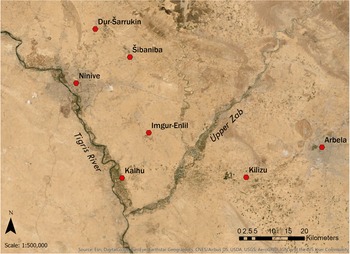
Map of the Assyrian core in the Neo-Assyrian period (ESRI Basemap)

Šibaniba in the Assyrian Empire
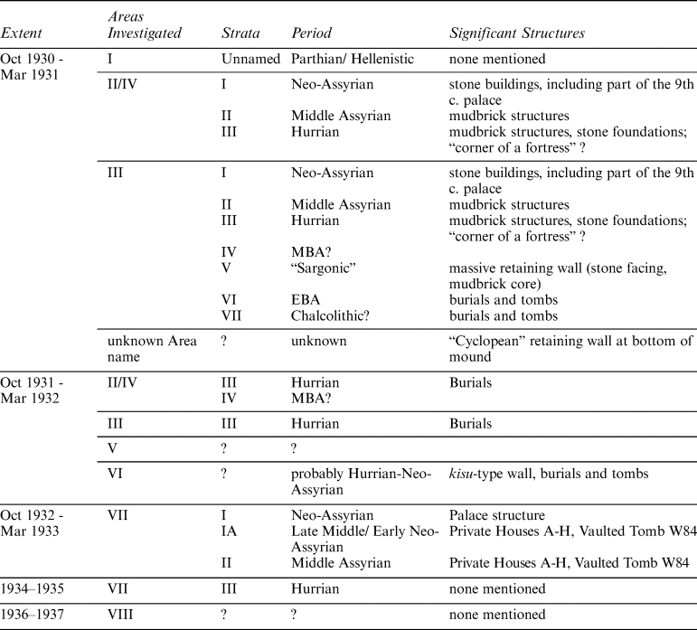
Šibaniba played a distinct role in the Assyrian Empire during the Middle and Neo-Assyrian periods. Prior to its status as an imperial entity, the site was likely of some importance in the earlier periods, as well. Though the field records themselves are spotty, the tell shows evidence for nearly continuous occupation from the Chalcolithic onward (see Table 1).Footnote 3 Šibaniba was located close to the core of the empire and was absorbed into its control at the beginning of expansion in the 14th century. Its location next to the foothills of the Jebel Bashiqa, but with access to plains, ensured that Šibaniba was particularly well-suited for agricultural and pastoral production and transport of commodities and people throughout its existence, as it lay nearby east-west trade routes (Altaweel Reference Altaweel2008). Due to Šibaniba's proximity to the Assyrian heartland, it is likely that it was one of the first to see an official established provincial government. In the time prior to the capital's establishment at Nineveh, it could have provided an otherwise-lacking center for control of the Upper Zab area. Though Assyrian power contracted in the twelfth century, a series of campaigns in the early first millennium led to re-expansion by the Assyrians, including a re-establishment of Assyrian hegemony at Šibaniba, which had experienced a short phase of independence. A century after this, a series of vigorous campaigns established Assyrian rule from the Zagros Mountains in the east to the Mediterranean in the west. Šibaniba remained a seat of provincial governance while the empire expanded to its largest extent (Liverani Reference Liverani1988).
A Summary of the Investigations at Tell Billa, compiled from correspondence letters (Penn Museum Archives)

The epigraphic material sheds further light on Šibaniba's place within the empire. Texts from Tell Billa fall into two categories: documents from what was likely the residence of a local governing family and dating to the Middle Assyrian period, and texts from the Neo-Assyrian period from the 9th century. J. Finkelstein (Reference Finkelstein1953: 116) has been able to date the Neo-Assyrian texts to the reign of Šalmaneser III (859-824 BCE).
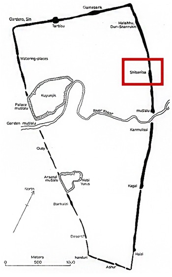
These documents bear a military theme, showing evidence for military recruiting from Šibaniba and the surrounding towns in several of the documents (Bi 72–77) from the 9th century. The positioning of troops by Šibaniba is interesting in this regard, because it is listed as one of the settlements which rose against Šalmaneser III in revolt. Despite this insurgency, Šamši-Adad V (824-811 BCE), Šalmaneser III's successor, put down the revolt and less than a generation later, Balāṭu, šaknu of Šibaniba, served as an eponym for the Assyrian calendar in 786 B.C.E. (shared also with Nabû-šarru-uṣur, governor of Talmusa) – a position reserved for officials of great importance (Grayson Reference Grayson1996: 0.103.1.1).Footnote 4 The abrupt forgiveness and re-integration into the Assyrian fold likely is indicative of Šibaniba's importance to the Empire, especially during its expansion far beyond the heartland. This importance was possibly due to the military function of Šibaniba as we have just seen, but also likely due to its production of resources. The town's situation on an agriculturally-productive plain, adjacent to the foothills of the Kurdish mountains, allowed it to provide both grain and flocks for the Empire. Perhaps most indicative of this role is the full title of Nineveh's Šibaniba Gate: dumuq ašnānu dlaḫar qereb-ša kayyān abul Šibaniba – “the choicest of grain and flocks are ever within it, the Šibaniba Gate,” (see Fig. 2) (Reade Reference Reade1978: 52). This, combined with the numerous documents detailing receipts and collections of sheep found at Billa, led Finkelstein to propose that Šibaniba might have been a central marketing point for sheep in the region (Reference Finkelstein1953: 118). One list even enumerates the manors of the area (dunnū) from which sheep were to be collected.
The Gates of Nineveh, with the Šibaniba Gate marked (after Reade Reference Reade1978).

The town's proximity to Nineveh and its situation at the entrance to the foothills of Jebel Bashiqa (likely Assyrian Mount Muṣri) also ensured its importance in Sennacherib's (705-681 BCE) water-supply construction.Footnote 5 That his famous canal passed through Tell Billa on its way to supply Nineveh is proven by inscribed brick fragments of Sennacherib found on the surface of the tell (Speiser Reference Speiser1934). Šibaniba appears in external sources from the ninth century onward mostly in the form of royal inscriptions, most famous of which is undoubtedly Sennacherib's Bavian inscription from 694 B.C.E.: “At the head of Dur-Ištar, Šibaniba, and Sulu I saw streams and enlarged their narrow sources and turned them into rivers. To [give] these waters a course [through] the steep mountains I cut through the difficult places with axes and directed their outflow onto the plain of Nineveh,” (Jacobsen Reference Jacobsen and Lloyd1935: 34).Footnote 6 Additionally, Sennacherib's Khinnis inscription from the year 688 reads:
I greatly enlarged the site of Nineveh… Its fields, which through lack of water had fallen into neglect (lit., ruin) and…, while its people, ignorant of artificial irrigation, turned their eyes heavenward for showers of rain — [these fields] I watered; and from the villages of Masiti, Banbarina, Šapparišu, Kar-Šamaš-naṣir, Kar-Nuri, Rimusa, Hatâ, Dalain, Reš Eni, Sulu, Dur-[Ištar], Šibaniba, Isparirra, Gingiliniš, Nampagate, Tillu, Alumsusi, (and) the waters which were above the town of Hadabiti eighteen canals I dug [and] directed their course into the Khosr River. From the border of the town of Kisiri to the midst of Nineveh I dug a canal; those waters I caused to flow therein. Sennacherib's Channel I called its name. (Jacobsen Reference Jacobsen and Lloyd1935: 34).
To summarize, then, it seems that Šibaniba's importance within the Assyrian Empire was due to its situation on an agriculturally rich plain adjacent to Jebel Bashiqa. Here it served as a military staging center, a depot for flocks, and a midway point between the water supply for Sennacherib's irrigation program and Nineveh.
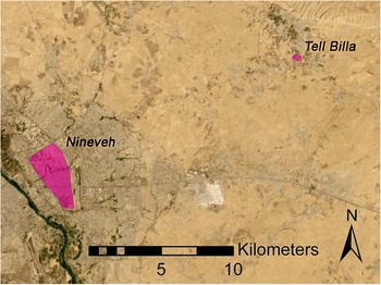
Modern map showing Nineveh and Tell Billa (ESRI Basemap).

The Excavations
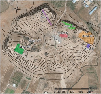
The site of Tell Billa was first brought to the attention of the international archaeological community by Sir Austen Henry Layard in his famous 1848 survey of Northern Mesopotamia, published in “Nineveh and its Remains”. Over seventy years later, E.A. Speiser led a survey to the area in 1927 with plans to explore potential sites for excavations. Tell Billa was particularly attractive due to inscribed brick fragments detailing Assyrian building projects on the site that had been found on the surface of the mound. Excavations began at the site in November 1930 with the hopes of both investigating the Assyrian levels of this site and procuring artifacts for the Penn Museum's collections. Starting in the northeast corner of the mound, Speiser and his colleagues led a force of over 100 local workers to excavate five Areas (see Fig. 4). The goal of the first season was to identify the span of occupation for the site, and in Area III they excavated down to virgin soil after Speiser identified at least seven distinct phases of occupation, preliminarily assigned titles such as “Hurrian” and “Assyrian” phases (see Table 1).Footnote 7 Though few excavation records remain, it is possible to briefly discuss the major importance of these Areas by revisiting the letters written as monthly briefings between Speiser and C. Bache (the Field Director of the Tell Billa excavations) and the American Schools of Oriental Research. Despite their vagueness, the monthly descriptions of new architecture and discoveries help to elucidate the importance of these Areas.
The modern mound of Tell Billa, with excavation areas marked (exact boundaries of Area VI unknown) (basemap: Google Earth 2018).

Tell Billa's long history of Parthian and Hellenistic occupation first came to light with the excavations of Area I in the northwestern corner of the mound. This area was quickly closed after it became clear that Assyrian levels would lie deep underneath the Hellenistic material.
Areas II and III quickly proved to have Assyrian material much closer to the surface. One Assyrian stratum in both Areas identified by Speiser contained predominantly mudbrick architecture. A number of inscribed bricks of Aššurnasirpal II (883-859 BCE) and Šalmaneser III were recovered from Strata 2 and 3 (both appropriately dated to Assyrian times) and Speiser claimed to have identified the 9th century remains of an Assyrian palace in the northern part of the citadel on the mound. The Assyrian levels in the northern part of the mound extended to roughly two meters below the surface. Another notable find recorded in Speiser's report was a fragment of a prism containing a typical inscription describing soldiers, tribute, booty, and punishment, “all in Aššurnasirpal's best style” (letter written by Speiser in 1930, Penn Museum Archives). Numerous graves were also found that dated to Assyrian occupation – Speiser describes that most were single jar graves, “usually with a shallow bowl placed near the opening of the [jar]… which is always laid on its side instead of standing up.”
During the fall of 1931, Speiser led a second season in which the team investigated the northeast corner and the southwest corner of the mound with the expectation of encountering further Assyrian occupation levels. While continuing investigations in Areas II, III, and IV, a trial trench was also dug at the base of the eastern slope. Here the team revealed a “Cyclopean” retaining wall, identifiable in some areas to reach a height of 4.5 meters and as wide as 2.5 meters. In the southwest corner they started at the top of a wadi cutting through the middle of the mound's western slope (marked “Area VI” on Fig. 4). The excavators identified this area as “Persian” (see below for a discussion of re-dating) and postulated that it was used as a necropolis by those who occupied this part of the mound.
As they moved east of the wadi in the second season, the team traced walls of sun-dried brick faced with baked brick, which Speiser compared to the building style of the palaces of Nineveh and Khorsabad. No further information is provided about this structure. As mentioned above, the excavations at Billa uncovered evidence for a royal building (possibly palace) of Aššurnasirpal II and Šalmaneser III. A temple to Ištar was also likely present at the site, located in the southwest corner of the tell. This identification is supported by a document listing houses with various professionals – among them, musicians, temple administrators, devotees of the goddess, and augurs (Finkelstein Reference Finkelstein1953: B i 85). The topmost level of this area yielded an inscribed brick describing the restoration of a shrine of Ištar by Šalmaneser III, found at the threshold of a large building which could have itself been the shrine.
Expanding outwards from the wadi, a cache of cuneiform tablets dating to the late Middle Assyrian and the early Neo-Assyrian periods was uncovered (spanning the 13th through 9th centuries B.C.E.). This discovery and the promising foray into Assyrian levels led them in the third season (1932–33) to focus solely on the southwest corner of the mound in hopes of uncovering more epigraphic material.
In this regard they were disappointed, but they succeeded in excavating a large residential area spanning Strata II and IA (Bache Reference Bache1935). The southwest corner of the mound, what I have designated Area VII for clarity, is the best-represented part of Tell Billa in terms of preserved documentation and plans. This area was divided into three levels by the excavators: Level I, Level IA, and Level II. It was originally assumed by the excavators that Level I dated to the Achaemenid period, while Level IA and Level II dated to Assyrian occupation. However, upon a reassessment of the material, it is clear that Level I instead dates to the latter half of the Neo-Assyrian period, Level IA dates to the reigns of Aššurnaṣirpal II and Šalmaneser III, and Level II dates to Tukulti-Ninurta I (1243-1207 BCE) or earlier. The re-dating the levels of the southwestern corner will be discussed further below.
Unfortunately, excavation at Tell Billa all but ceased during the next two seasons (carried out in 1934–35 and 1936–37), leading to few discoveries and even fewer surviving records. Today, little information is known about Tell Billa; a select few preliminary reports sent directly from the field were published in University of Pennsylvania Museum Bulletins (1930–1936), and no final excavation volume was compiled. Besides the field report on the third season published by Bache (Reference Bache1935) and two later analyses of the tablets – one on the Middle Assyrian glyptic (Matthews Reference Matthews1991) and one on the texts themselves (Finkelstein Reference Finkelstein1953) – the data from Tell Billa remain unpublished, owing no doubt to the fragmentary nature of the surviving records. Now, the Penn Museum archives hold the remaining records, including the excavation's correspondence letters, financial records, and several sets of field “notecards,” including artifacts, loci, and burials. Our only maps, plans, and descriptive fieldnotes hail from the third season.
Reassessing the Stratigraphy
The loss of excavation records and the misidentification of certain strata by the original excavators necessitate a critical reevaluation of the material. Throughout the seasons of excavation at Tell Billa, the excavators altered their chronological interpretations of the different strata in several instances. While the northeast corner of the mound remained fairly static in its temporal interpretation due to the wealth of artifacts and architectural structures (as well as benefitting from the initial trench in Area III extending all the way to virgin soil), the southwestern corner's stratigraphy remains somewhat unclear in the records. Due to recent developments in our understanding of ceramic chronologies from the Assyrian and post-Assyrian periods, the original recorded dates now need revision.Footnote 8
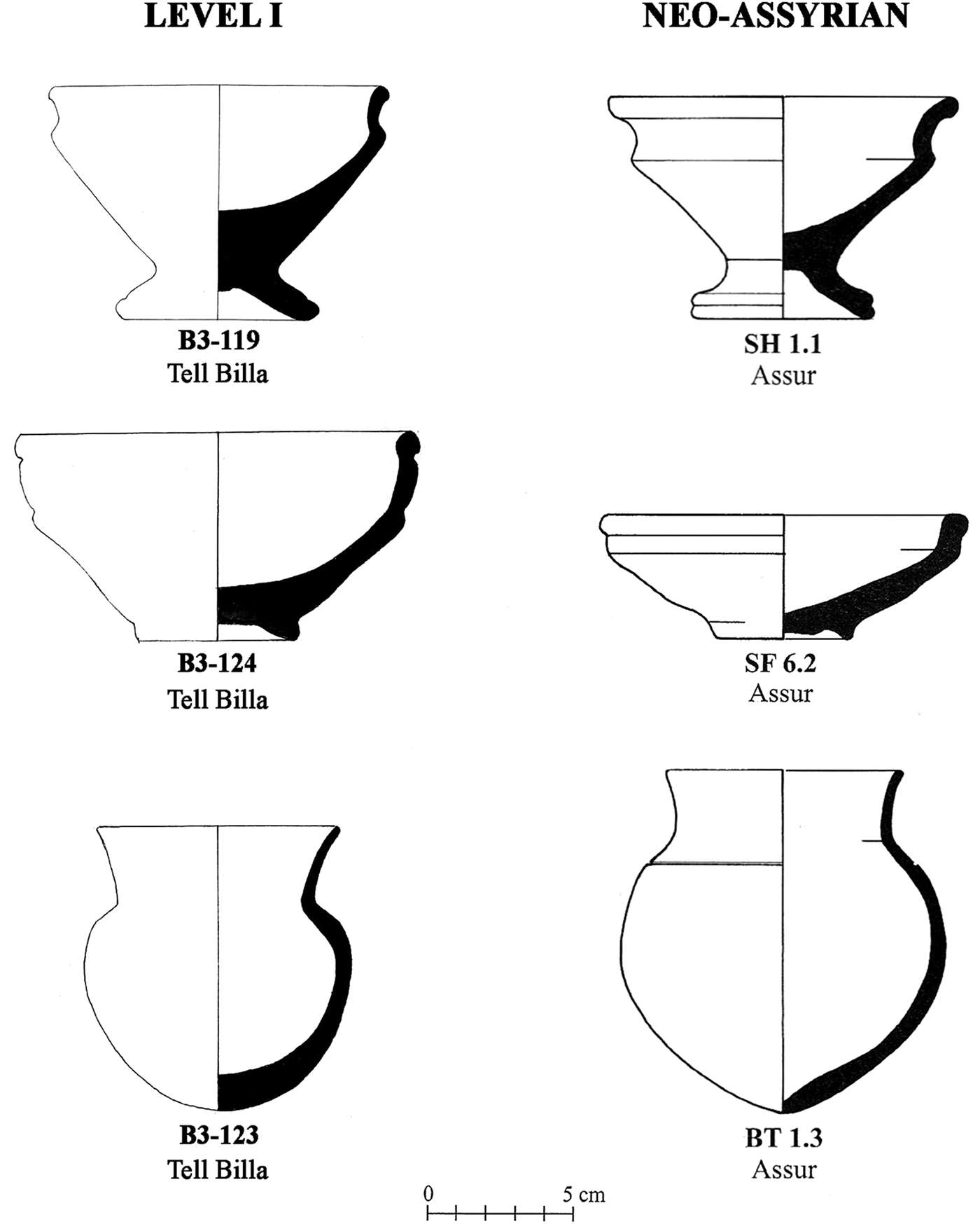
By comparing the Tell Billa ceramics with corpora from secure contexts at other contemporary sites, it is possible to draw parallels between the ceramics from the Šibaniba Area VII Levels I, IA, and II and typical shapes of the Middle and Neo-Assyrian periods (see Figs. 5 & 6). Due to the presence of glazed pottery in Level I contexts, the excavators assumed that Level I must be Persian. However, almost a century's worth of research since then has shown that glazed ceramics were abundant in the Neo-Assyrian period, and no shapes in the Šibaniba records from Level I seem out of place in a typical Neo-Assyrian assemblage (Fig. 5).Footnote 9 Several shapes shown from Level I in Figure 5 are distinctive of the Neo-Assyrian period: carinated bowls with high stands (B3-119 compared to Hausleiter's type SH 1.1), footed bowls with rounded rims (B3-124 compared to Hausleiter's type SF 6.2) carinated beakers with flaring rims (B3-123 compared to Hausleiter's type BT1.3; Hausleiter Reference Hausleiter2010).
Comparisons between Level I ceramics at Tell Billa and Neo-Assyrian ceramics (examples after Hausleiter Reference Hausleiter2010).

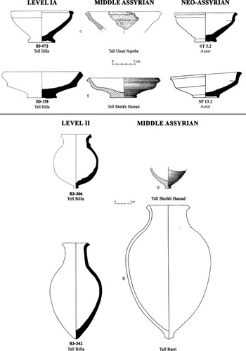
Furthermore, ceramics from Tell Billa's Level II occupation correlate with typical Middle-Assyrian assemblages (see Fig. 6). Level IA contained ceramics which fit in late Middle-Assyrian and early Neo-Assyrian contexts.Footnote 10 This re-dating agrees with the historical sources from this area of Šibaniba, which largely fall between the reigns of Adad-Nirari I (1295-1264 BCE) in the 13th century and Shalmaneser III in the 9th century of the late Middle Assyrian and early Neo-Assyrian periods. Inscribed brick fragments found on the mound's southwestern surface from the reign of Sennacherib show that Šibaniba's Assyrian occupation continued into the 7th century as well – also part of Level I.
Comparisons between Level IA and II ceramics at Tell Billa and Middle Assyrian ceramics (examples after Pfälzner Reference Pfälzner1995) and Neo-Assyrian ceramics, showing similarities between the two corpi (examples after Hausleiter Reference Hausleiter2010).

The Remains of Level I
With Level I dated to the Neo-Assyrian period, we may now move into the discussion of the architecture and finds from this period to understand the nature of occupation in the southwestern corner of Tell Billa's mound.
Description of the Structures
The Level I architecture consists of one main structure, with several “rooms” nearby. As mentioned, high levels of erosion damaged the first level of habitation on this portion of the mound. As Bache noted:
[t]he chief characteristic of the topmost level in this area is the profusion with which stone was used—as a foundation for walls, and as pavements. The level lay so close to the present surface of the mound that it was nearly impossible to distinguish the libn of the walls from the debris that surrounded them. Colour we found to be the surest criterion, the mud-bricks being so rotted by exposure and by constantly having been ploughed over that there was little of their original texture left. (Bache, Feb 1933, letter from the Penn Museum Archives).
It is likely due to the hardiness of the preferred stone architecture of this period that we have any remains left to analyze.
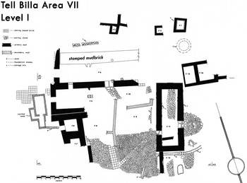
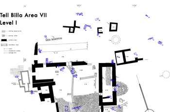
Though the structures were heavily weathered, Bache was able to identify fourteen discrete “rooms” – including several storage pits, drain systems, and a large cobblestone courtyard centrally located amongst the other structures (Fig. 7). Prior construction in this area from Level IA and II differ greatly from Level I; the two earlier phases contained a series of domestic housing along two main streets, with minor construction differences between the two occupation phases (see Reference CreamerCreamer, forthcoming).Footnote 11
Plan of Area VII at Tell Billa, displaying the structures of Level I (modified from map of 1932–33 excavation season, Penn Museum Archives).

Level I, however, shows discontinuity with the earlier phases. It has none of the same structures as the previous two – and instead contains the remains of what was once a large complex: the rooms marked P5-P11 form the remains of a monumental building constructed around the courtyard.Footnote 12 The open area to the east of P11 and P12 was likely also part of this complex, though no walls were preserved. Other Level I structures were likely unrelated to the main complex (P1-3, P13, P14). At least one of these was used as a storage bin (P1), and the other “rooms” may have had similar functions. The plastered and sloping interior walls of structure P1 support this interpretation. Also within P1 is evidence of its construction at a later date, due to it being built of inscribed bricks from the reign of Sennacherib. Structures P2, P3, P13, and P14 were also considered storage bins by the excavators. P2 and P3 were too poorly-preserved to venture any further speculation. P13 and P14 were sizable rooms that could have been associated with the main structure, especially considering their proximity to the northeastern corner of P11.
The monumental architecture's best-preserved room was P11 – including one long room, oriented N-S and partly paved with stone. At a later phase, a mudbrick curtain wall separated the small area in the south. To its west was attached a complex of walls enclosing a large, mudbrick-and-stone paved courtyard (comprised of areas P8 and P9). Small secondary mudbrick curtain walls separated these areas at a later period, and it is likely that the broken walls running east-west at one point completely divided courtyard P8/9 from room P5/P10.
In the area to the east of P11 a semi-circular paving of stones encircles the eastern entrance to P11, possibly indicating it led into an unroofed area. Drain systems were built to filter water out from the central courtyard. One drain led under the east wall of the courtyard into Area 12, where it drained out. Another drain led from Room P6 west into a vaulted tomb originally constructed in Level II. The tomb had been emptied since its use, now utilized in Level I as a cistern. Evidence of a similar drain leading west out of Room P7 was mentioned in the field notecards, although not recorded on the plan. Neither Room P6 nor P7 could be entered from the courtyard. Room P6 was entered from the west, which is also where the drain led out into the cistern. Because of the drain, the excavators speculated that this might be a bathroom. P7, though only partly-preserved, seemed to have had similar dimensions to P6, although its use is unknown.
North of P6 and P7, an entrance from the west into P5 was paved with baked brick over the vaulted tomb. There were three entrances in the thick wall running E-W to the north of P5 and P10, leading into P4, also paved with baked brick and cobbled stone thresholds. In the middle entrance were two large threshold stones. On the north side of the wall just east of this entrance were two door sockets, made of bricks inscribed with the inscriptions of Šalmaneser III. Like the Sennacherib bricks from the P1 structure, these bricks were reused in the construction, providing a terminus post quem for the Level I complex of the mid 9th century. P4 itself was a large room, its dimensions unknown due to no northern or eastern wall being preserved. The open space of P4 included a stretch of mudbrick stamped pavement, running from east to west (marked in Fig. 7). Just north of this and running parallel to it was a short piece of wall foundation stones, two courses thick. The broken remains of thin walls extending west, east, and north of area P3 might be associated with these remains, though they seem too thin. The westward-running wall associated with P3 might extend far enough to intersect with the wall running north-south if it continued this far north.
Level I Artifacts
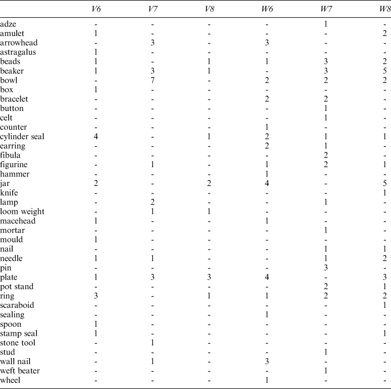
Because of the lost records of the Tell Billa Assyrian Expedition, we are left with few details. This includes the records of the artifacts found. For the third season, the information attached to finds was only recorded on individual notecards, later entered in a simplified form in the season's register. Provenience in these records is limited only to Level and Square (V6, V7, V8, W6, W7, W8). These 20 × 20 m squares often contain multiple structures, and therefore matching particular objects to the room they were found in – to say nothing of their exact context – is difficult. Despite contextual shortcomings, I present here the artifacts found in Level I in non-burial contexts with the goal of using the artifacts to elucidate possible functions of parts of the structure (see Table 2).
Level I object counts per Square, by type, based on excavation records from the 1932–33 field season (Penn Museum Archives).

Square V6, containing small chamber P3 and large vestibule P4, is characterized by a number of personal effects, such as cylinder seals, a stamp seal, rings, an amulet, and an animal astragalus used as a gamepiece. A mould and a needle could indicate specialized craft functions in this area. Pottery was of the usual type. It is when we also look at Square V7's contents, the area also encompassing part of P4 (along with storage pit P1, unknown chamber P2, and small parts of P13 and P14) that further evidence for varied craft production is seen in the presence of a loom weight, a second needle, and an unidentified stone tool. Peculiar here is the find of three bronze arrowheads. Considering a similar find of three more arrowheads is found in Square W6, it is difficult to attribute this to specific storage – instead, it is better to say that a part of this palace within this general area likely served as a repository for weapons – also including the maceheads found in V6 and W6. This was a common function for palaces, and to see it reflected in the objects from this structure is unsurprising, especially when we have textual evidence of Šibaniba serving as a depot for mobilizing troops (Finkelstein Reference Finkelstein1953: 118). Square V8 contained little coherent architecture, and likewise the finds from this area suggest nothing particular about its function.
Square W6, as already mentioned, contained a number of weapons. Vestibule P5/P10, courtyard P8/P9, and small chambers P6 and P7 are all included in this area – making it difficult to pair exact contexts with artifacts found. Likewise, the objects from Square W6 reflect a number of different functions. Seals, game counters, a ceramic wheel from a model or toy, a figurine, and jewelry were personal objects and could have come from residential chambers (possibly P6 and P7 if a comparison with other palaces is to be borne out – discussed further below). Of particular interest is the find of three wall nails from this area, uninscribed. Because the only other wall nail was found in Square V7, it is likely that these decorated the southern wall of vestibule P4 – the only structure shared by the two areas. If this is the case, then P4 may have had further decoration lost to us, indicating that it might have been used for receiving visitors, or used as living quarters (as opposed to more mundane tasks such as storage, bathrooms, kitchens, etc.).
Square W7 contained many structures: part of vestibule P5/P10, part of courtyard P8/P9, vestibule P11, small chambers P13 and P14, and parts of open area P12. Beyond an adze, celt, mortar, nail, and a metal stud – all of which indicate that part of this area was likely involved in craft production – the objects are of a personal nature. Jewelry, figurines, fibulae, and a button were all related to individual ownership. The presence of a needle and weaving tool could have been kept on one's person as personal objects, or also could likewise signal further production in this area. Square W8, likewise, contains two needles, possibly from the same context as the previous. Other objects in W8 consist of the usual pottery, a knife, jewelry, and two seals.
Level I Burials
The objects included in the above analysis were recovered from living levels of the Neo-Assyrian settlement, but further information can be gleaned from the contemporary burials located within and around this structure. As mentioned above, the Level I remains from Area VII were found to be severely eroded in excavations. However, some burials were associated with certain structures. Most notable among these were a cluster of seven burials underneath what was likely once a courtyard leading into a monumental structure (P10, P5, & P4) (see Fig. 8). The burials in this cluster were grouped by their relation to the pathway into the building (B20, B13, B16) and their association with the main wall of the building (B14, B17, B6, B15). Four of these seven burials were built from mudbrick, and all contained adult occupants. Wealth (number and quality of grave goods) varied between the burials, but the similarity in construction could indicate that it was members of a single group (whether familial or communal) that were burying their dead in this area.
The burials dated to Level I at Tell Billa, shown overlaid with the architecture (after basemap of 1932–33 excavations at Tell Billa and Level I burial map, Penn Museum Archives).

Another group of burials in Level I were related to structure P11: B58, B59, B61, and B70. While the excavators did not speculate on the nature of the room, its relationship to the courtyard likely indicates that it, also, was related in some way to the monumental complex formed by these structures. The burials in P11 were all in ceramic containers (Type 3), with three adults and one infant. There were no notable characteristics of these burials, save for that three of the four were oriented on an E-W axis. While interacting with the walls of P11, they did not follow the same alignment – which could indicate a purposeful choice in burial orientation.
Assyrian Elite Architecture
The objects and burials together paint a picture of an inhabited structure of some importance. In a letter to the Museum in February 1933, Bache wrote, “Since it is the part of the mound that is closest to Nineveh, I hope also that we may find more important buildings.” Their hopes came to fruition. The size and organization of the main complex in Level I, Area VII, leads us to consider it as an example of palatial architecture at one of Assyria's most central provincial sites. This identification is borne out in comparisons. Palatial architecture of the NA period is, fortunately, a well-discussed topic stemming from numerous material and textual examples. Excavations at Assyrian capitals and provincial centers alike have revealed palaces, often well-preserved due to the sturdiness of the building materials employed and the care with which they were constructed. As vehicles for royal propaganda, the palace often took center stage in not only administrative duties, but also in their functions as distribution centers, arsenals, residences, craft areas, etc. The palace – both in capitals and provinces – was a multi-functional, multi-faceted entity that necessarily served in many capacities while also being at the forefront as a mechanism of imperial control (Bietak and Prell Reference Bietak and Prell2018). Perhaps it is for this reason that palatial architecture, especially in the first millennium, took on a standardized architectural “type”. Variations in this “type” were consciously catalogued and employed by the Assyrian elite. For example, the bit-hilani structure – which served as another well-known architectural option – was likely utilized as propaganda much in the same way that wall-reliefs depicted tribute scenes: as mastery over foreign material and ideas and, therefore, a control over foreign lands and people (Winter Reference Winter1993).
Though Assyrian palaces vary in terms of scale and details (see Turner Reference Turner1970 for a discussion of the variations in state rooms, in particular) – generally, several key features stand out. Chief among these is that they are centered upon double-courtyards – an outer, public one and an inner, more private court. The outer courtyard is intended for palace visitors to traverse before reaching the state chambers, where the ruler of the palace is located within a throne room, often accessed via vestibules on either side. The inner courtyard served a more private function. Often, residential chambers were oriented around the inner courtyard, along with smaller rooms that some have identified as storage (Turner Reference Turner1970). This inner part of the palace served as the “household” portion of the “great house” – with evidence for cooking, household craft production, and residential quarters.
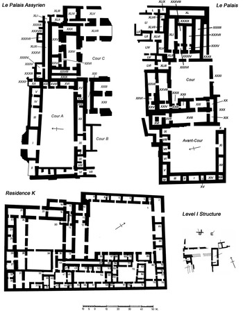
For our purposes, this brief description of palatial architecture is sufficient to proceed in our comparison of the Level I structures at Tell Billa to other NA palatial buildings. The features of Level I in the SW corner of the mound were poorly-preserved, but enough remains to draw parallels between it and other contemporary palace structures. Though it shares features with many examples, I will use the palatial architecture found at Khorsabad (Residence K), Tell Ahmar (Le palais assyrien), and Arslan Tash (Le palais) as case studies, shown side-by-side with Tell Billa's Level I structure in Fig. 9.
Plans of Le palais assyrien at Tell Ahmar (after Thureau-Dangin et al. Reference Thureau-Dangin, Dunand, Cavro and Dossin1936, Plans B and C), Le palais at Arslan Tash (after Thureau-Dangin et al. Reference Thureau-Dangin, Barrios, Dossin and Dunand1931, Plan 2), Residence K at Khorsabad (after Loud & Altman Reference Loud and Altman1938, pl.71), and the Level I structure at Tell Billa (after archival material at the Penn Museum). All displayed at same scale. Note the similarities between Tell Billa's structure and the courtyards organizations of the others.

As already mentioned, the Level I structure at Tell Billa is comprised of several separate rooms, clustered around a central courtyard paved with cobbles and baked bricks. This courtyard, designated areas P9 and P8, I argue served as the inner courtyard in a typical palace structure. Rooms P6 and P7 most likely functioned as parts of living quarters (as Turner identified similar rooms 22, 23, and 25 in his analysis of Residence K at Khorsabad (1970) and Thureau-Dangin identified rooms XXVIII, XXIV, XXIII, XXII, XXVII, XXVI, and XXV at Arslan Tash (1931: 22–27)).Footnote 13 P11 parallels the vestibule 14 at Khorsabad and XXIV at Til Barsip which lead into their respective throne rooms, and it would not be a stretch to think that a similar throne room might have existed directly east of P11 at Tell Billa. For example, the room XVIII was the largest room of the palace at Arslan Tash, and formed part of the reception suite – leading to the north into XVII and XVI, the throne room. Thureau-Dangin suggested that Room XVIII had offset entrances to afford privacy to the inner courtyard complex, similar to P11 (1931: 20). If these connections are borne out, then it would make sense to associate “living quarters” XXVIII and XXVII with rooms P5/10 and P4. Looking at the large number of personal objects from the squares V6, W6, and W7, this interpretation would make a great deal of sense. The stone feature in P4 might also be equated with a similar feature recorded from Room XXVIII.
Based on a comparison to similar rooms at Til Barsip (XLVII), Arslan Tash (XXVIII), and Khorsabad (24), P5/P10 (once again, later divided by a mudbrick curtain wall) would have likewise served as one vestibule – leading into “private” sections of the household located to the north (also unexcavated, although the floating structures P3, P2, and P1 might have been small rooms for storage, if they were contemporary with the rest of the structure). P4 was another large room. Though it was poorly-preserved upon excavation, it is possible from its position in relation to courtyard P8/P9 and vestibule P5/10 to draw parallels between it and room XLV at Til Barsip and XXVII at Arslan Tash. Evidently parts of the floor had to be levelled, as shown by the mudbrick floor extending through it.
This reconstruction of the Level I structure at Tell Billa proposes that the outer court and the palace's “public space” would have stretched to the east of the surviving structures – which remained unexcavated. The main peculiarity of this structure which sets it apart from other contemporary palaces is the degree to which stone is employed as a construction material. While baked brick flooring was found preserved in several areas (shown in Fig. 7) and therefore was likely present elsewhere in the palace as well, a majority of the courtyard is paved in cobbles. Furthermore, the entrance to P11 and part of the flooring is also paved with stone, along with several unidentifiable features in the area P12. This emphasis on stone could show an effort to construct a long-lasting palace and showcase a wide array of resources (Winter Reference Winter1993:32). Despite this idiosyncrasy, it is clear that these remains of monumental architecture correlates well with contemporary examples of palaces in the Assyrian sphere. Lending further support to this notion is Šibaniba's importance with the Assyrian Empire.
Discussion: An Advantageous Position
From the textual evidence discussed earlier, we can guess that Šibaniba's continuing importance as a provincial center likely lay in its advantageous location, where it was able to serve as a supply point for military, a central marketing point for flocks, and a step in Sennacherib's grand water constructions.Footnote 14 If this is indeed correct, then there is no wonder at the monumental constructions built on Šibaniba's tell. The attention paid to the city by Assyrian rulers in the 9th century onwards was predicated on its already-crucial contributions to the empire and its prior importance in the Bronze Age. The importance of the site only increased over the next centuries, likely reaching its highest point when Nineveh was the Assyrian capital under Sennacherib and later rulers.
Tell Billa's proximity to Nineveh certainly affected its role within the Empire. Though it was located at a distance from earlier capitals (102 kilometers from Assur in the MA period and 38 kilometers from Kalḫu in the mid 9th c.) the later capitals of Dur-Šarrukin and Nineveh shortened this distance to a meager 14 kilometers and 17.5 kilometers, respectively – less than a day's walk. Dur-Šarrukin was short-lived as a capital, and likely did not affect Šibaniba much in the less-than-fifteen years it functioned as the Empire's capital. However, with the declaration of Nineveh's central status, it is possible that the relation between it and Šibaniba caused changes to both Šibaniba's political status and its physical arrangement.
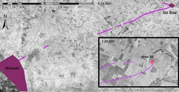
As mentioned above, Speiser believed he had come across the remains of a 9th c. palace during his excavations in the northern part of Tell Billa. Because records are missing from this season, it is impossible to verify this claim, save for the knowledge that Aššurnasirpal II and Šalmaneser III had a residence at Šibaniba, based on inscribed bricks uncovered in situ in the northern part of the mound, and in secondary contexts re-used as building material in the southwestern part of the mound. Instead of the presence of this northern palace precluding the notion that there could be a second palace located in the southwestern portion of the mound, I argue instead that this corner of the mound became a desirable place to build another palace. This was the part of the mound closest to Nineveh – leading me to believe it was established during Nineveh's tenure as capital. Lending further support to this is the identification of the main road leading from the Šibaniba Gate of Nineveh, straight to Šibaniba's mound, entering at the southwestern corner (see Fig. 10).
Hollow-ways (traced in purple) leading from the Šibaniba Gate of Nineveh to the southwestern corner (Area VII) of Tell Billa. Two tracks (A and B) were likely leading to entrances granting access the citadel, adjacent to the Level I palace structure in Area VII (CORONA mission 1104-2138F002 and F003; Aug 1968, courtesy of the Center for Advanced Spatial Technologies, University of Arkansas/U.S. Geological Survey). For an expanded picture of hollow-ways within the Nineveh area, see Altaweel Reference Altaweel2003; Reference Altaweel2005.

We can form a tentative reconstruction of where main entrances to the city on top of the tell were based on tracing the vestiges of ancient routes left in the modern landscape. “Hollow-ways” are linear indents in the landscape, sometimes as wide as 30 m across, that were formed by travelers repeatedly compacting the dirt surface (Altaweel Reference Altaweel2003; Casana Reference Casana2013; Ur Reference Ur2010; Wilkinson Reference Wilkinson1993). Over a period of hundreds of years, commonly-used paths were permanently integrated into the landscape. In cases where modern development is only a fairly recent phenomenon, traces of these hollow-ways can still be seen in satellite imagery. Perhaps the best imagery to use to identify these routes for most of northern Mesopotamia is that of declassified CORONA missions flown over this area in the 1960s and early 70s (Ur Reference Ur2003).Footnote 15 In these shots, hollow-ways show up as lighter lines in the landscape.
Starting from the Šibaniba gate, a hollow-way can mostly be followed which crosses the plains between Nineveh and Billa. As it nears Billa, it appears that it separates into at least two separate paths; one approaching the mound from the south to crest the mound just east of the palace structure (Track A), and a second which enters the tell from the west almost exactly where the modern road runs (Track B) (Fig. 10 inset). As can be seen in the overlaid excavation area, the architecture in the southwestern corner of the mound discussed above is located closest to the entrance of Track A (Fig. 10 inset).
During the late period of the Assyrian Empire, it is likely that this land between Nineveh and Šibaniba was entirely farmland – possibly irrigated with Sennacherib's water works to increase production drastically needed to support the demand of population supercenters in the Heartland (Altaweel Reference Altaweel2008; Wilkinson et al. Reference Wilkinson, Wilkinson, Ur and Altaweel2005). The palace on the southwestern part of the mound of Šibaniba would be immediately visible to those travelling between the capital and Šibaniba or to those (likely displaced deportees) settled and working the region between the two cities. Furthermore, positioning the palace at the main entrances to the mound provided convenient administration and control of people and goods moving in and out – a crucial function provided by provincial administrators. This might show an active effort on the Assyrians’ part to restructure the layout of an existing town to preference Nineveh once it became a capital in the NA period. Before this (and to some extent, during), it seems that most public buildings were located in the northern part of the mound. Changing the character of the southwestern area from private domestic in the MA period to public could have been a purposeful effort, reflecting a tightening of administration focused on strengthening Šibaniba's ties to the new capital.
Conclusions
In sum, the remains of a monumental structure in Level I of Tell Billa's southwestern section of the mound can be assumed to have functioned as a palace – possibly the residence of the local provincial governor – constructed towards the end of the Assyrian Empire at a time when Nineveh served as the imperial capital. The architecture of the remaining rooms readily parallels existing palatial structures – specifically the “innermost” part of the palace that served as a residence and domestic production center. Its position at the main entrance to the citadel furthermore provided a prime position for the head official to carry out his duties, especially as they related to the comings-and-goings from the capital at Nineveh.
A restructuring of the town on top of the tell might betray a further willingness to restructure entire settlements to preference Nineveh. The movement of the Assyrian capital from one city to another brought with it not only a change in administration, but also physical changes to the local landscape and settlement patterns – impacting local towns beyond the normal Assyrian tactics of resettlement and agricultural intensification seen in other areas (Parker Reference Parker2012). I believe these changes were a mixture of purposeful, top-down decisions (building a palace on the part of the tell facing Nineveh) and incidental results (strengthened control over the plain between the sites, further agricultural production as a result of irrigation works, etc.). The extent to which the Assyrian Empire impacted local patterns of development based on administrative location is unknown, yet a clue might be gained from the changes within city layouts in relation to events within the empire. Šibaniba, despite being located so close to the Heartland and Nineveh, was an important administrative center in its own right, and provides just one notable example of what is certainly a wider phenomenon to be explored. As further investigation into the Tell Billa records proceeds, it is hoped that the importance of the site within the context of Assyrian imperial development will be further clarified.
Acknowledgements
The research presented here would not have been possible without the knowledgeable and supportive staff of the Penn Museum Archives. This project was carried out with the support of the University of Pennsylvania Price Lab for Digital Humanities. Additional thanks are owed to Emily Hammer and Lauren Ristvet for offering comments on earlier versions of this article.