The identity of Classic Maya elites was expressed through public architecture and the creation of a sacred landscape, which incorporated the landscape of creation (Reilly 1995) with concepts of the world tree and the quadripartite division of the cosmos (Mathews and Garber 2004), as well as cosmological concepts in dedicatory caches (Bozarth and Guderjan 2004; Guderjan 2004a). Pyramids, plazas, stelae, and ballcourts were important components of this landscape. In the eastern Peten, architectural complexes known as “E-groups” were another component. In this article, I describe a temporally late, regional variant of this architectural assemblage, which I term “pseudo–E-groups” (Figure 1). Further, I argue that the integration of pseudo–E-groups into Late Classic sites in the eastern Peten was a function of how Maya ruling lineages identified themselves, as well as how a regional architectural assemblage is an expression of internal integration.

Location map showing sites mentioned in the text.
E-GROUPS AS AN ARCHITECTURAL FORM
More than a hundred E-groups or, more properly, E-group–type architectural assemblages have been identified in the southern Maya Lowlands (Aveni et al. 2003; Chase and Chase 1995; Ricketson 1928; Savoie 2004). The assemblage was first identified as an architectural form based on Group E at Uaxactun (Ruppert 1940). Uaxactun's Group E consists of a plaza complex with three temples (Structures E1, E-2, and E-3) on top of a large, shared substructural platform on the east side of the plaza. The west side is defined by Structure E-7, a four-sided building. This complex was believed by both Ricketson and Ruppert to be an observatory used for marking the solstices and equinoxes, a view that has been confirmed by Anthony Aveni and Horst Hartung (1989). Since Ruppert identified the Uaxactun assemblage, at least 100 such architectural arrangements have been identified in the Maya Lowlands, mostly in the Peten physiographic region of the southern Maya Lowlands (Aveni et al. 2003). For convenience, these are generally termed “E-groups.”
There is significant temporal and regional variability among E-groups. The Terminal Preclassic Uaxactun case may have been the prototype for later arrangements at other Maya centers (Aveni et al. 2003). Certainly, it is one of the earliest to have been built and an early center of power at Uaxactun. Further, the astronomical alignments of the Uaxactun E-group were designed for precise observations (Aveni, Dowd, and Vining 2003). Later E-group complexes were aligned differently, and Aveni and his colleagues argue that the Early Classic alignments were influenced by the twenty-day calendar being imported into the Maya Lowlands from Teotihuacan (Aveni and Hartung 1989, 2000; Aveni et al. 2003).
Another important example of an E-group complex is found in the Mundo Perdido at Tikal. Juan Pedro La Porte and Vilma Fialko (1990) argue that the initial version of this complex predates the Uaxactun complex by several hundred years. Certainly by the Late Preclassic, though, this was an important public ritual complex at Tikal. Further, by the Early Classic period (Manik 1 phase), the Mundo Perdido complex was very similar to Group E at Uaxactun. It consisted of three buildings sharing a platform on the east side of the plaza. The central building that formed the west side of the complex was, like at Uaxactun, decorated with stair-side masks (LaPorte and Fialko 1990).
However, LaPorte and Fialko (1990) argue that E-groups in the early Classic period were not used as observatories but instead were commemorative astronomical complexes and a form of a broader category of triadic pattern architecture. In a related argument, Aveni, Anne Dowd, and Benjamin Vining (2003) argue that the changing form of Early Classic E-groups reflects a response to changes in the Maya calendar due to influences from Teotihuacan at the time. Regardless of why forms and orientations changed, LaPorte and Fialko (1990) argue that these complexes became a defining element integrated into the identity of elite lineages at Tikal. E-group Complexes' importance, then, was less based on their function as observatories as on their social function. While it is likely that the initial complexes built in the Terminal Preclassic period at Uaxactun and Tikal were designed to be functional observatories, the continued use and modification of the Mundo Perdido complex at Tikal became a defining element for Early Classic elite and royal lineages.
Also relevant to understanding the significance of E-group complexes is the recent argument by Prudence Rice (2004) that Maya polities organized the assumption of power through a process known as the seating of the may and involving ceremonial ascription of authority to a lineage every fifty-two years. Rice pursues the concept that triadic structures and, later, E-group complexes were the location for the ritual seating of the may and the assumption of responsibility of authority by a lineage. If so, the E-group complexes and, by extension, pseudo–E-groups, were integral to ruling lineages and visually marked their presence and existence. Similarly, ballcourts embodied ritual relationships with the underworld and through those relationships marked the authority of royal lineages. This may be why, as James Aimers (1993) noted, E-groups and ballcourts are often located in proximity to each other.
There is significant regional variability among E-groups, but the shift to forms that were not functional as observatories seems to have been widespread. For example, at Pacbitun in the Belize Valley, the E-group consists of a Middle Preclassic pyramid that later had northern and southern additions constructed (Healy et al. 2004). These buildings became the eastern triadic complex, and the major temple across the plaza became the fourth, western structure by the Early Classic. However, this does not appear to have been a functional observatory. Yet, as elsewhere in the Peten, the E-group complex was a necessary and defining architectural complex for the identity of the Pacbitun ruling elites.
PSEUDO–E-GROUPS IN THE EASTERN PETEN
Pseudo–E-groups in the eastern Peten consist simply of two buildings sometimes linked by a common substructure that bound the east side of a large plaza. In addition, and unlike the central Peten version seen at Tikal and Uaxactun, these complexes do not have a western building to functionally complete the observatory. Instead, if they had a viewing position, it would be somewhere in midplaza. None, however, are known to exist and elsewhere they are unmarked. Geographically, this form seems to be limited to the eastern edge of the Peten zone as it merges with the Belize Coastal Plain. In addition, all of these complexes appear to date to the early part of the Late Classic, much later than Terminal Preclassic and Early Classic E-groups. While it is likely that such complexes exist elsewhere, the following four sites show the commonality of Late Classic pseudo–E–groups.
Blue Creek: Structures 2 and 3
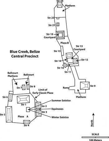
Intensive and extensive excavations since 1992 at the site of Blue Creek in northwestern Belize have yielded a rich and important database that can be applied to many questions in Maya archaeology (Guderjan, Baker, and Lichtenstein 2003; Guderjan, Lichtenstein, and Hanratty 2003). Plaza A and the buildings surrounding it were nearly all constructed in the Terminal Preclassic and Early Classic period (Guderjan 2004b). By the end of the Early Classic, the plaza was bounded by large structures except on the east side (Figure 2). Adjacent to Plaza A was a ballcourt that was also built in the Early Classic. As most ballcourts in northwestern Belize were built in the Late Classic, this raises the possibility that Blue Creek enjoyed independence based on its important economic base in the Early Classic that was not enjoyed by its neighbors (Guderjan 2004b, 2006).

Plaza A, Blue Creek, showing the Early and Late Classic configurations and the approximate viewing point for astronomical observations.
Blue Creek is situated at the top of the 100–150 m high Bravo Escarpment, and the open side of Plaza A overlooked the agricultural lands and residential barrios below (Guderjan 2006). In the Early Classic period, the eastern edge of the plaza was faced with a 2 m tall, masonry wall. In the early part of the Late Classic (Aguas Turbias phase at Blue Creek, or Tepeu 1 [a.d. 600–700]), the plaza was expanded eastward approximately 20 m to accommodate the construction of Structures 2 and 3, both approximately 8 m tall (Figure 2). When we first saw these buildings in 1990, massive frontal looting trenches had been dug into them that ahd destroyed much evidence of the details of the architecture. However, excavations at Structure 3 confirm major construction in the early part of the Late Classic. Later, a large frontal staircase was added, and finally a third construction extended the staircase to the incorporate a small masonry shrine.
The shrine consisted of a small arched room, extending 80 cm from the staircase. It was 3 m wide and at least 2.5 m tall, with a low door that was approximately 80 cm wide and 1 m tall. The interior chamber was 1.6 m tall and 1.15 m wide. The chamber had well-preserved plaster walls and floor. Set into the floor was a limestone boulder or pseudo-stela projecting approximately 60 cm above the floor (Guderjan 2002). Directly below the shrine was a dedicatory cache consisting of a lidded effigy vessel containing sponges (Bozarth and Guderjan 2004), jade and greenstone artifacts, spondylus shells, coral fragments, mica fragments, fish bones, and stingray spines. Also, a fiberous substance was identified visually as kapok from the ceiba tree (Driver and Wanyerka 2002). However, this is probably incorrect, as large quantities of sponge spicules would form similar masses. Thousands of such spicules were identified by microscopic analysis of biosilicates (Bozarth and Guderjan 2004), and no other evidence of kapok or ceiba was found. W. David Driver and Phil Wanyerka (2002) interpret the identity of the effigy vessel as Kinich Ahau, the sun god; others identify it as God K (Guderjan 2002). However, all interpretations of this cache have focused on the symbolic representation of the Maya cosmos and creation themes (Bozarth and Guderjan 2004; Driver and Wanyerka 2002; Guderjan 2004a).
If this pair of buildings had functioned as an observatory, the third building—the viewing point of the complex—would be in the midplaza area. Despite the damage to the tops of the buildings due to looting, an area within the plaza was identified (Figure 2), and surface inspection and excavations were conducted, but no evidence of any sort of marker for a viewing point was located. More important, the elevation at Plaza A is approximately 110 m above the base of the escarpment. Consequently, the sun would not be observed rising above Structures 2 and 3 until midmorning, when it would be too high and too large in the sky to measure the sunrise location with any precision.
This pair of buildings mimicked the earlier E-groups but was completely nonfunctional. However, during the Late Classic period, the ruling elites of Blue Creek found it necessary to incorporate these two buildings into their sacred landscape. I argue that this need was based not on desire for the function of an E-group but on the integration of the idea of an E-group into the sacred space of a polity and the need for its rulers to incorporate such a complex because it was a necessary part of their identity.
Chan Chich: Structures A7, A8, and A9
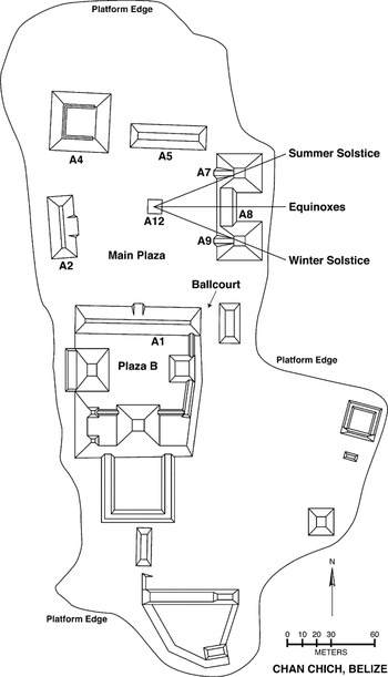
Chan Chich, another medium-size site in northwestern Belize, was originally mapped by the author (Guderjan 1991). However, more recent work by Brett Houk and his associates (Houk 1998, 2000; Houk and Robichaux 1997) has greatly expanded our understanding of the site. The pseudo–E-group at Chan Chich is on the east side of the Main Plaza. In my original map, these buildings were numbered Structures 5a and 5b and shown on a shared low platform. When Houk remapped the site, he renumbered the buildings and gave the low platform its own structure number. Figure 3 derives from Houk's survey of the site. Significant changes in the map resulted from Houk's efforts, and his numbering system is followed.

Chan Chich, plan of major architecture, showing pseudo–E-group on east side, modified from Guderjan (1991) and Houk (1998).
The southern or Upper Plaza at Chan Chich has a long construction history beginning in the Middle Preclassic and continuing through the Late Classic (Robichaux 1998). However, the entire Main Plaza appears to be a Late Classic addition to Chan Chich's public architecture (Guderjan 1991; Houk 1998). Further, Chan Chich's ballcourt was built in the Late Classic (Tepeu 2–3) by adding a single structure parallel to the east side of Upper Plaza platform. The pseudo–E-group formed by Structures A7, A8, and A9 was part of this expansion. Structures A7 and A9 are both approximately 8 m tall and, like the Blue Creek buildings, had substantial frontal looting trenches when we first saw them, revealing that both were single-phase constructions probably resulting from the same event (Guderjan 1991).
Again, like the pseudo–E-group at Blue Creek, there is no building on the western side of the plaza to complete a functional observatory complex. The opposing building, Structure A3, is off-axis from A7 and A9 and much too distant to be used for such a function. While there is a small, low platform in midplaza, Structure A11, Houk reports being present at Structure A11 at the summer solstice. The sunrise was “nowhere near Structures A-7 or A-9” (Houk 2000:101). While his excavation of Structure A11 confirmed that it dated to the Late Classic and was not a modern rubble pile (Houk 2000:101–104), it remains problematic in form and function.
In the Chan Chich case, then, the pseudo–E-group was again not a part of a functional observatory complex. Interestingly, the need for the presence of a ballcourt at Chan Chich was also recognized and addressed in the Late Classic in the less than robust manner of building only half of a ballcourt and modifying existing architecture to form the other half (Ford 1998). This adds credence to the notion that the two assemblages were linked to establishment of the Maya identity.
San Jose: Structures A3 and A4
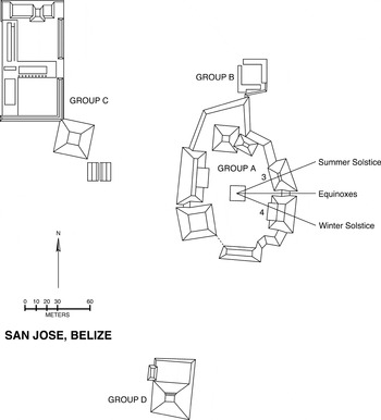
San Jose is another Belize site of the general scale of Blue Creek and Chan Chich (Figure 4). The excavations of San Jose in the 1930s by J. Eric S. Thompson (1939), while intensive, were not regularized from building to building. Consequently, our understanding of the two relevant structures is somewhat vague, and their construction histories may not be parallel. Despite this vagueness, they appear to fit the pattern of pseudo–E-groups.

San Jose, plan of architecture, modified from Thompson (1939).
Structure A3 was 12 m tall, and Structure A4 was “approximately 10 [m]” tall (Thompson 1939:46–47). However, there appears to have been a Late Classic addition to Structure A3 that elevated the building 1.4 m that did not have a parallel construction on Structure A4. Prior to that construction, the two structures were approximately the same height, and the major construction of both dates to the early part of the Late Classic. As in the Chan Chich and Blue Creek cases, there is no corresponding building on the west side of the plaza that could have functioned as an observation point. Like at Chan Chich, the ballcourt at San Jose was added in the latter part of the Late Classic, again supporting a linkage between these two assemblages and the idea that these architectural forms were associated with the identity of Maya elites that were required in such polities during the Late Classic.
Quam Hill: Structures 13 and 14
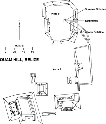
Quam Hill is a poorly known site of the same scale as Blue Creek, Chan Chich, and San Jose that, like Blue Creek, is situated at the top of the Bravo Escarpment. Michael Lindeman mapped the site in 1990 (Guderjan 1991), and no excavations have ever been undertaken there. Nevertheless, Quam Hill is clearly a large and important site, with at least two plazas and two stelae. Structures 13 and 14 are both 12 m tall and define the east side of Plaza B (Figure 5). Both structures are undated. Likewise, the ballcourt at Quam Hill is undated, but its location within Plaza A suggests that it is a Late Classic addition. While future investigations at the site are required to clarify its relationship to the others discussed here and whether the buildings are actually another pseudo–E–group, Quam Hill is very likely another such case.

Quam Hill, showing the locations of Structures 13 and 14 and the ballcourt, modified from Guderjan (1991).
DISCUSSION
Pseudo–E-groups share important formal, spatial, and temporal traits. Their formal arrangements consist of two identical or nearly identical buildings, which may be built on shared platforms, on the east side of major public plazas. They are aligned along or nearly along a north–south axis. In each case, there is no corresponding structure on the west side of the plazas to serve as an observatory point, as there is in the Uaxactun Group E prototype. Consequently, pseudo–E-groups are probably not functional as observatories, unless some point in midplaza was used as an observation point. So regardless of whether Aveni and colleagues (Aveni et al. 2003) or LaPorte and Fialko (1990) are correct regarding the functions of Early Classic E-groups, these assemblages did not function as observatories in the Late Classic. Instead, they had become embedded into the Maya conception of necessary elements in public architecture. This can be likened to other archaizing traits, such as mansard roofs in late-twentiety-century buildings or Greek-revival architecture in the antebellum southern United States. Neither functioned for their original purposes, but both are expressions of the identity and values of their builders.
Pseudo–E-groups also appear to be spatially and temporally bounded. The four sites discussed here are all on the eastern edge of the Peten physiographic area, marked by the Bravo Escarpment. This corresponds to the boundary between the Chol and Yucatecan speakers in the historic period (Roys 1954) and corresponds well to a group of Classic sites with planning similarities that can be interpreted at as an integrated cultural unit (Houk 1997, 2002). Further, the datable known pseudo–E-groups date to the early part of the Late Classic, roughly Tepeu 1–2. It is probably also important that at these sites, with the exception of Blue Creek, ballcourts were built at approximately the same time. In the Blue Creek case, an unusual Early Classic ballcourt already existed.
It is clear that the Maya often used stylistic traits to express integration among Maya communities. Brett Houk's study of site planning supports the applicability of that principle in the eastern Peten. Further, other studies, such as those of Joseph Ball (1993) and Shirley Mock (1997), indicate that stylistic variability of ceramics is useful as an indicator of cultural boundaries. Consequently, the continuities of public displays through monumental architecture can be seen as expressions of cultural integration and the cultural identities of the builders. I argue that pseudo–E-groups were just that. In the early part of the Late Classic, on the eastern edge of the Peten, pseudo–E-groups were expressions of the Maya identity. They were an archaizing trait that referred back to the polities of the central Peten hundreds of years earlier. Further, they expressed the part of the identity of Maya elites that required public display of such concepts through monumental architecture.
RESUMEN
La identidad del Periodo Clásico fue expresado en la arquitectura publica y en la creación de un medioambiente sagrado en los cuales están incluido el incorporación de una representación de la creación en un espacio material y el concepto del árbol mundial. Entre las características importantes de este espacio sagrado se encuentren los pirámides, las estelas, las plazas, y las canchas de pelota. En el oriente del Petén también se encuentre una característica, lo que es un complejo arquitectural “Grupo-E.”
Los Grupos-E están bien conocidos como “calendarios de orientación” y fueron construidos primeramente en el Periodo Preclásico Terminal. Nombrado por el Grupo-E en el sitio de Uaxactun, se consiste de dos edificios construidos en el lado éste de una plaza publica y un tercer edificio construido o en el mediano de la misma plaza o en el lado oeste. Hasta ahora casi cien configuraciones de este estilo están identificados. En el Periodo Preclásico Terminal los Grupos-E funcionaron como marcadores de solsticios y equinoccios. Sin embargo, en el Clásico Temprano, supuestamente por la influencia de Teotihuacan, se cambiaron en función a enfocar en el ciclo anual de agricultura.
El argumento que se encuentre en este obra es que durante un gran parte del Periodo Clásico Tarde el construcción de lo que puede estar nombrado como “Seudos-Grupos-E” se continuaba y son estos complejos arquitectural que mas definen el región del Petén oriental en este época. Al entrar en el Periodo Clásico Tarde los Grupos-E han perdido los funciones para hacer observaciones del sol o del ciclo de agricultura. Sin embargo estuvieron tan vinculados dentro de la esquema de arquitectura de lo que estuvo considerado como necesario para un espacio sagrado que la continuación del construcción del Seudo-Grupo-E fue considerado como necesario para respaldar la identidad de una ciudad y establecer un reno como legitimó.
ACKNOWLEDGMENTS
I thank Wendy Ashmore, Anthony Aveni, and Brett Houk for their insightful comments, which much improved this paper. Since 1992, research at Blue Creek has been conducted under permits from the government of Belize. More important, the work has benefited from the support and insight of the commissioners and staff of the Department of Archaeology, now the Institute of Archaeology. None of our work could have been accomplished without a mutually supportive team effort by the staff, students, and volunteers of the Blue Creek project. I also thank Dustin Ward for the new renderings of the figures used in this article, and Grace Bascope for her assistance with the Spanish resumen.