

Introduction
The Early Bronze Age (EBA) of the Southern Levant (contemporary Israel, Jordan and the Palestinian Authority) was the first period in which settlements were encircled with large walls clearly intended to serve as fortifications. These fortifications grew progressively in size, peaking in their scale towards the end of the period. Many researchers (e.g. Burke Reference Burke2004; Callaway Reference Callaway1980, 147; Kempinski Reference Kempinski, Kempinski and Reich1992; Paz Reference Paz2011) have regarded this as clear evidence that the period was characterized by a high level of conflict and that these structures actually served as barriers against organized violence imposed by other settlements and groups. Other scholars doubted this explanation, stressing instead other functions of these fortifications (e.g. Joffe Reference Joffe1993, 71; Miroschedji Reference Miroschedji2018a; Philip Reference Philip2003, 112–13). Neither side of the debate ever clearly elaborated why their arguments were correct. They usually relied on common sense, or pointed to the mere existence of these monumental structures. Furthermore, while the rise and evolution of hierarchy and leadership and the role of war and violence in this process have been discussed at length for different regions of the world (e.g. Clastres Reference Clastres1987; Jennings & Earle Reference Jennings and Earle2016; Smith Reference Smith2003; Stanish Reference Stanish2017), there are relatively few recent publications dealing with these processes in the southern Levant (notable are Chesson Reference Chesson2015; Philip Reference Philip and Adams2008). The possible non-military use of fortifications was extensively dealt with in other regions and periods, e.g. the Iberian peninsula Chalcolithic period (Oosterbeek Reference Oosterbeek and Carman1997), third- and second-millennium Egypt (Kemp Reference Kemp2004; Moeller Reference Moeller2004), and even in later periods, such as late medieval England (Creighton Reference Creighton2005; Johnson Reference Johnson2002; Liddiard Reference Liddiard2005). As shown below, the EBA of the southern Levant, with its lack of weapons and other war-related evidence, deserves unique treatment, which will contribute to the above discussions.
This paper is a summary of an analysis of the tactical characteristics of several Early Bronze (EB) III fortifications, along with other war-related features of the period. It attempts to show that most of the EB fortifications were built in such a way as to promote a sense of strength and potency, but in fact lacked basic defensive features. The impressive EB III fortifications were an exaggerated statement of power that had some tactical and strategic value as deterrents. They also had other aims; the over-investment in their construction means that they were used to consolidate the society through the process of construction; their magnitude in comparison to the existing threats means that the dangers were exaggerated in order to ‘fortify’ and legitimize the newly acquired higher status of those who initiated and led the construction.
The EBA of the southern Levant, dated to c. 3700–2500/2450 bc, is usually divided into three sub-periods—EB I, II and III (Miroschedji Reference Miroschedji, Steiner and Killebrew2014; Regev et al. Reference Regev, de Miroschedji, Greenberg, Braun, Greenhut and Boaretto2012). The beginning of the period is characterized by small and large villages practising Mediterranean economy, which relied on olive and vine horticulture and sheep and goat pastoralism. Fortifications started to appear at the end of EB I (c. 3400–3100/3000 bc) and became progressively larger during the subsequent sub-periods. During EB I and II there is hardly any evidence of administration or social stratification in the form of staple or wealth finance, prestige items, craft specialization, or large private buildings. The major possible indications of a stratified society are fortifications and temples. During EB III (c. 2900–2500/2450 bc) (Regev et al. Reference Regev, de Miroschedji, Greenberg, Braun, Greenhut and Boaretto2012), a slow change can be discerned—few types of prestige items appear, a palace is built at Yarmuth and possibly at Megiddo, a central granary is erected at Tel Bet Yerah, and settlements and their fortifications become larger and larger, while small settlement are being deserted. The EB III fortifications are complex and elaborate structures that include many features such as bastions, gates and towers. Many of them were composed of several parallel walls, achieving cumulative widths of 8–15 m and more. Some scholars suggested a model of a corporate society of an intra-settlement heterarchy in which several groups with roughly the same social and economic power work together and manage communal efforts. Others argued for a centralized economy and an ideology that masked differentiation, especially during EB II (Berger Reference Berger2013; Chesson Reference Chesson2015; Chesson & Philip Reference Chesson and Philip2003; Genz Reference Genz2003; Greenberg Reference Greenberg, Faust and Maeir1999; Greenberg et al. Reference Greenberg, Ashkenazi and Berger2017; Harrison Reference Harrison and Chesson2011; Miroschedji Reference Miroschedji and Wolff2001; Philip Reference Philip and Adams2008).
The fortifications of the EBA were not a new phenomenon in the ancient Near East. A large wall with an attached tower was already found as early as the eighth millennium bc at the Neolithic site of Jericho (Kenyon Reference Kenyon1981), although its identification as a fortification wall is controversial (e.g. Bar-Yosef Reference Bar-Yosef1986; Nave Reference Nave2003). A buttressed fortification wall, indirect access gate and a ditch were found at sixth-millennium bc Tell Es-Sawwan, Iraq. Elaborate and sophisticated fortifications dated to the Uruk period and the beginning of Early Dynastic periods (c. 3900–3100 bc and 2900–2700 bc, respectively) were found in Mesopotamia at the sites of Habuba Kabira, Abu Salabik and Uruk. These fortifications consisted of wide walls, fortified gates and towers positioned within bowshot gaps (Kohlmeyer Reference Kohlmeyer and Meyers1997; Pollock Reference Pollock1999; Pollock et al. Reference Pollock, Steele and Pope1991; Strommenger Reference Strommenger1980; Zingarello Reference Zingarello, Affanni, Baccarin, Cordera, Di Michele and Gavagnin2015). The southern Levantine EBA fortifications appeared several centuries later and were probably based on enduring knowledge. Miroschedji (Reference Miroschedji, Shai, Chadwick, Hitchcock, Dagan, McKinny and Uziel2018b) argued that itinerant architects and builders held this knowledge and used it to build fortifications all over the region.
Research methods
Several criteria have been proposed for estimating the level of conflict-related stress on ancient societies (Arkush & Stanish Reference Arkush and Stanish2005; Earle Reference Earle1997, 117; Le Blanc Reference Le Blanc1999, 64; Monks Reference Monks1997; Paz Reference Paz2011; Vencl Reference Vencl1984; Walker Reference Walker2001). These include: the presence and quality of fortifications, available weaponry, settlement patterns, destructions, skeletal and mortuary data and artistic representations. In the following pages these criteria will be analysed.Footnote 1
The following analysis mainly deals with the EB III sub-period due to the magnitude and elaboration of the fortifications during this time. Eight sites were analysed. They were chosen for the large exposures of their fortification systems and their detailed publications, containing enough data to allow a thorough examination. These sites include ‘Ai, Bab edh-Dhra’, Hebron, Levi'a, Tel Bet Yerah, Tel Yarmuth, Tell el-Hesi and Zeraqun.
The sites
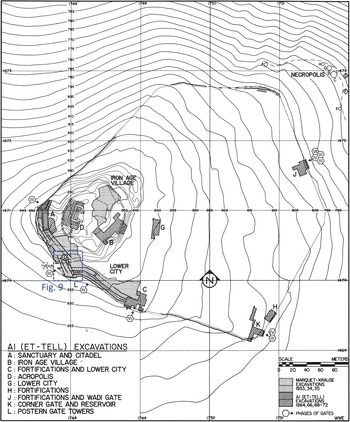
‘Ai (et-Tell) (Fig. 1) is an 11 ha site located in the Samarian Hills, north of Jerusalem. It was settled from the end of EB I to EB III. Three fortification walls were identified at the site. Fortification Wall C is dated to the end of EB I or the beginning of EB II. Wall B was built during the latter phase of EB II, and Wall A, which was built in front of the earlier fortifications, is dated to EB III. Their cumulative widths reached 8–15 m (Callaway Reference Callaway1980, 18; Reference Callaway and Stern1993; Herzog Reference Herzog1997, 67).
‘Ai (blue square shows areas appearing in Figure 9). (After Callaway Reference Callaway1980, fig. 2.)

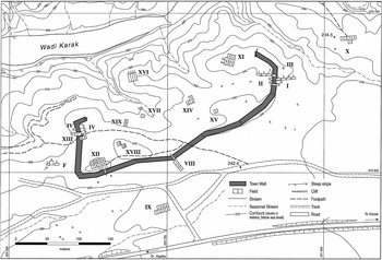
Bab edh-Dhra’ (Fig. 2) is located east of the Dead Sea, on the south bank of Wadi Kerak. The site was inhabited throughout the EBA and includes a walled settlement, extramural habitations and a cemetery. Two fortification walls were built during the EB II and EB III; Wall B (EB II, 2.5 m wide) and Wall A (EB III, 7–8 m wide) (Rast & Schaub Reference Rast and Schaub2003; Schaub Reference Schaub and Stern1993). These walls encompass an area of about 3.3 ha.
Bab Edh-Dhra’ fortifications. (After Rast & Schaub Reference Rast and Schaub2003, fig. 1.4.)

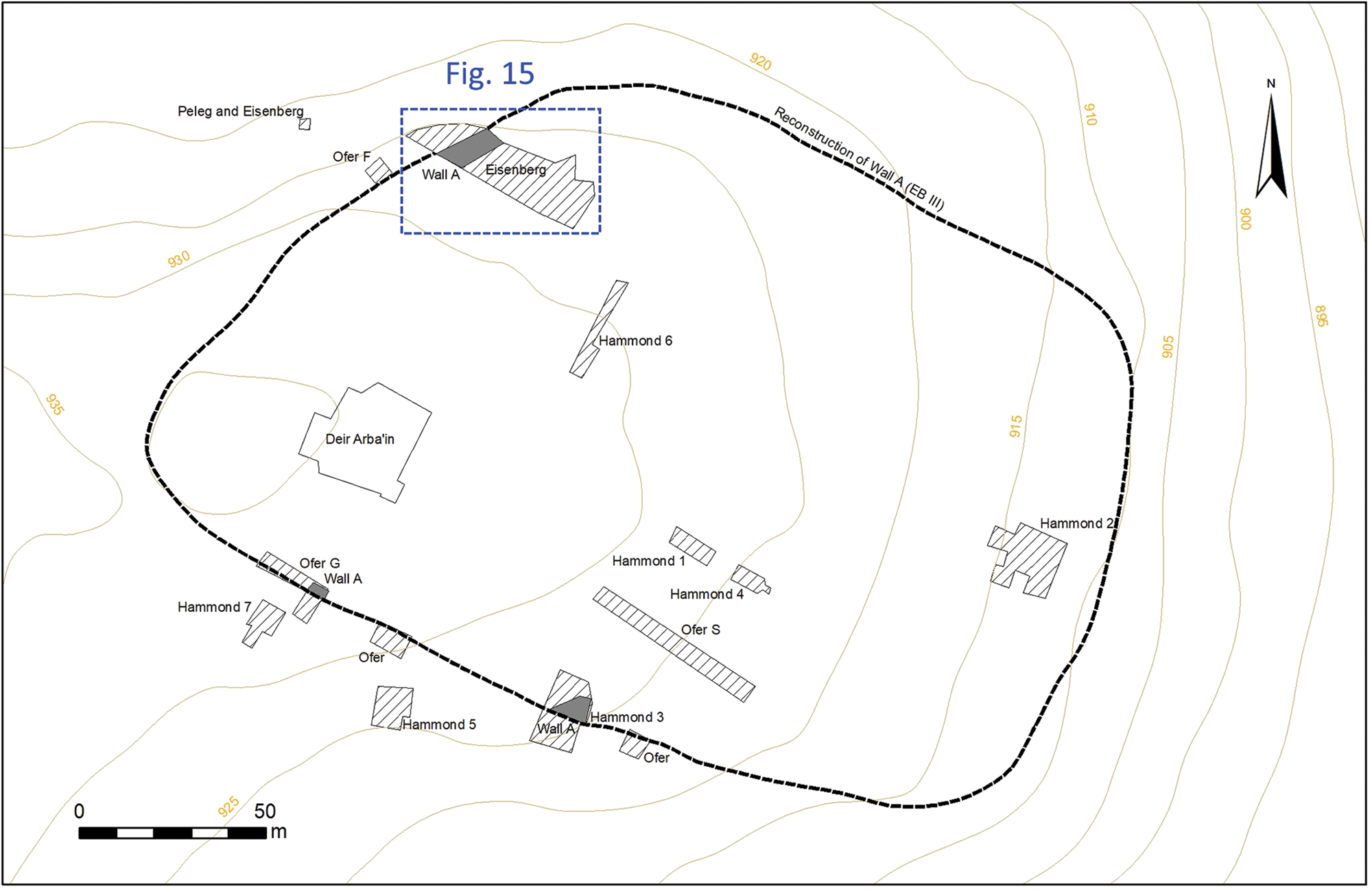
The site of Hebron (Fig. 3) is located in the Judean Hills, south of Jerusalem. It is positioned on a spur along the eastern side of Jebel Rumeida, below the top of the hill. It is a 3.3 ha site, dated to the EB III only, encircled by a large ‘Cyclopean’ fortification wall (Wall A) measuring 6.2 m wide at its base (Eisenberg Reference Eisenberg, Aviram, Gitin, Mazar, Na'aman, Stern and Zuckerman2011; Ofer Reference Ofer and Stern1993).
EB III Hebron fortification Wall A (excavated wall sections are marked in grey; excavation areas are hatched; blue square shows area enlarged in Figure 15.) (After Chadwick Reference Chadwick2005; Eisenberg Reference Eisenberg, Aviram, Gitin, Mazar, Na'aman, Stern and Zuckerman2011).

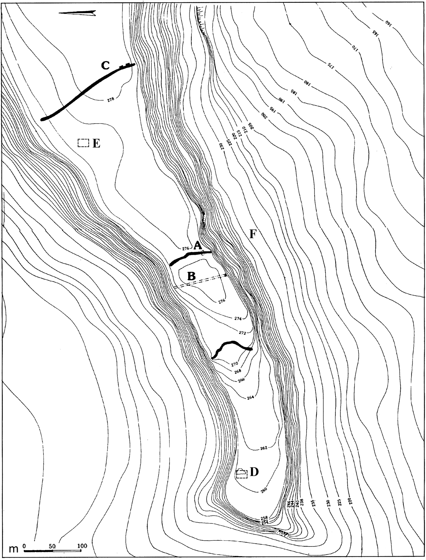
Leviah’ (Fig. 4) is a 9 ha fortified settlement situated in the southwest of the Golan. It was inhabited during the EB Ib to EB III. It is located on a spur and is cut off from the plateau to the east by two fortification walls. The external one (excavated as Area C, see Fig. 4) is 16 m wide, and the inner one (Area A), situated 250 m to the west of the external wall, is 10 m wide. Both have gates situated along the same axis. The other sides of the settlement, overlooking relatively steep gorges, were fortified as well, albeit with a thinner, 3–4 m wide wall (Kochavi & Paz Reference Kochavi, Paz and Stern2008; Paz Reference Paz2003; Reference Paz2011).
Leviah’. (After Paz Reference Paz2011, fig. 2.)

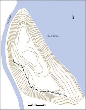
Tel Bet Yerah (Fig. 5) is a 28 ha site located on a small peninsula bordered by the Jordan River and the Sea of Galilee. Three fortification walls were built during the EBA. The first, Wall A, is an 8 m wide wall dated to the EB Ib/II. Wall B was built over Wall A during the EB III, and Wall C, also dated to the same sub-period, was built after Wall B went out of use. The width of both of the later walls is around 4 m. The fortification walls were built first along the south (Walls A and B) and then also along the west flank (Wall C), apparently leaving its northern and eastern flanks protected only by the river and lake. Wall C, excavated to its full length during the 1950s, is the most elaborate of the fortification walls. It was constructed with stone foundations and a mud-brick superstructure in a sawtooth pattern. It includes 15 round, square and horseshoe towers (Bar-Adon Reference Bar-Adon1955; Greenberg Reference Greenberg and Greenberg2014; Greenberg & Paz Reference Greenberg and Paz2005; Paz & Greenberg Reference Paz, Greenberg, Greenberg, Eisenberg, Paz and Paz2006).
Tel Bet Yerah reconstructed ancient topography, Wall C, and the Jordan River. (Courtesy of the Tel Bet Yerah Archaeological Project.)

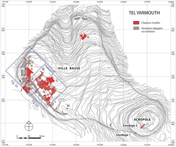
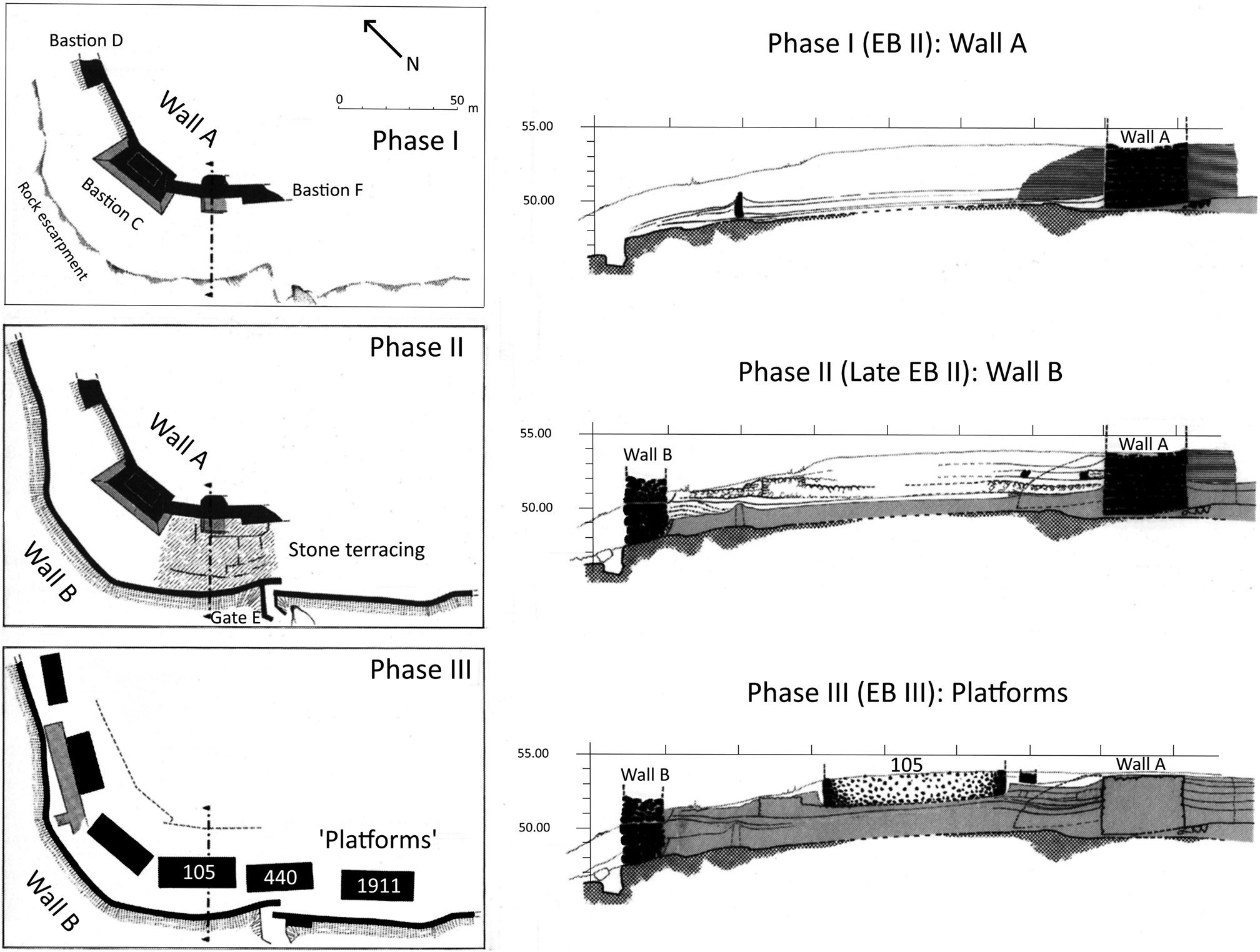
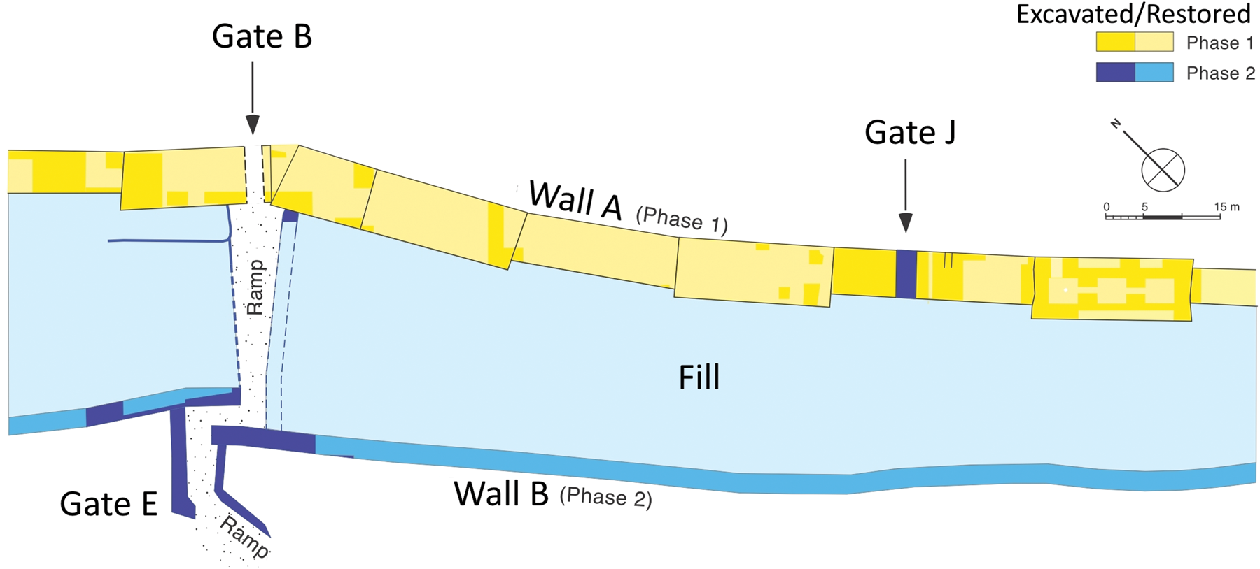
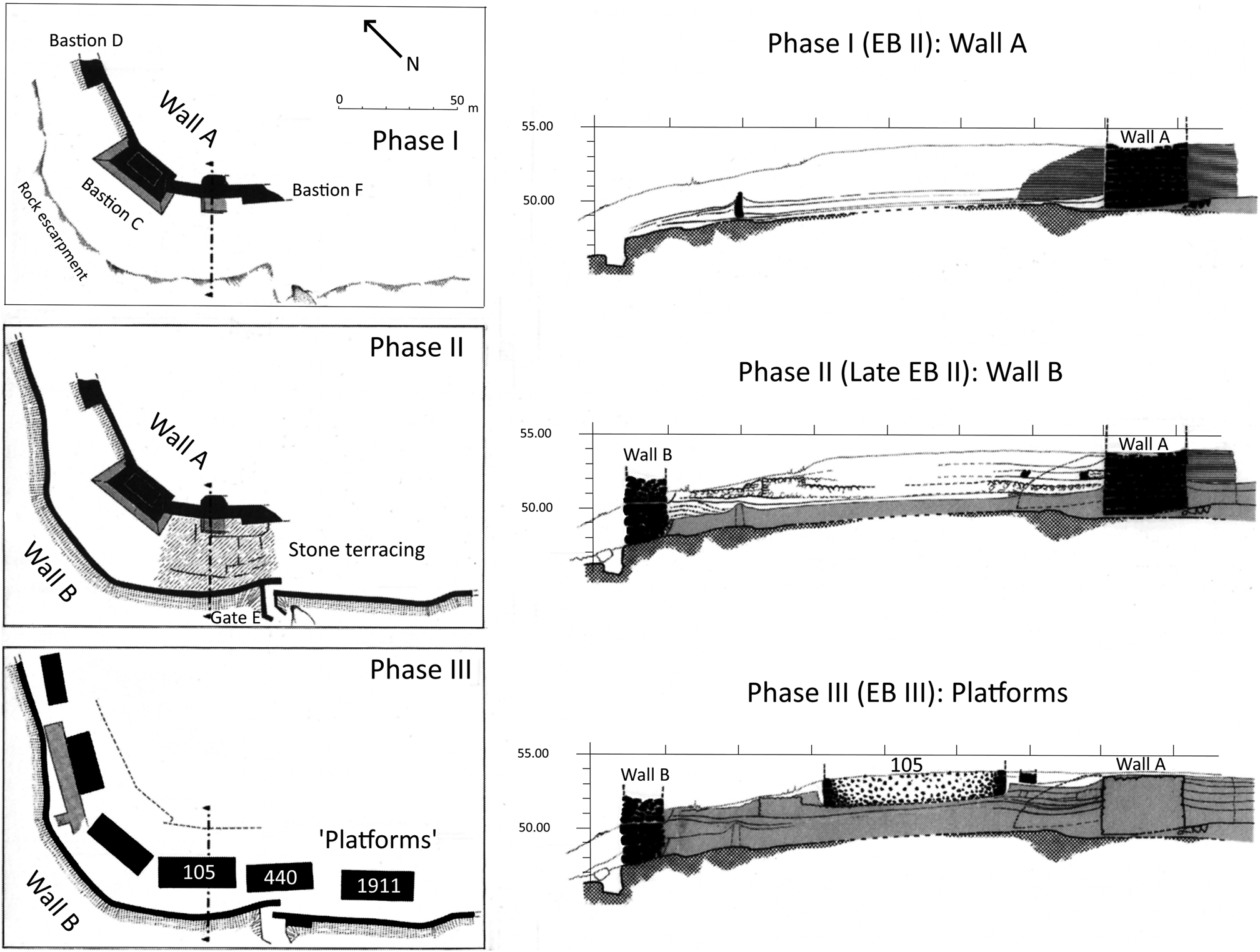
Tel Yarmuth (Fig. 6) is an 18 ha site located on a low peak at the foothills of the Judean Hills, southwest of Jerusalem. It was inhabited throughout the EBA. Two fortification walls were built around it. Wall A, measuring 4.25–6.4 m wide, was built at the beginning of the EB II. It incorporated bastions along its course and a direct-access gate (Gate J). Wall B, positioned in front of A, was built at the end of the EB II. Its width was 2.6 m and it consists of one indirect-access gate (Gate E, Fig. 16) and has no towers/bastions. In some locations, the gap between the walls was filled to create an impressive 40 m wide fortification system. During the EB III, Wall A went out of use and was covered by later construction and fill. Several freestanding internal bastions were then built on the western side of the site, between the two walls (Fig. 14). Palace B1, dated to the end of EB III and located in the same general area, was also built on top of Wall A (Miroschedji Reference Miroschedji2013; Reference Miroschedji, Steiner and Killebrew2014; Reference Miroschedji2018a).
Tel Yarmuth (blue squares show areas appearing in Figures 11 & 14). (After Miroschedji Reference Miroschedji2013, fig.1.)

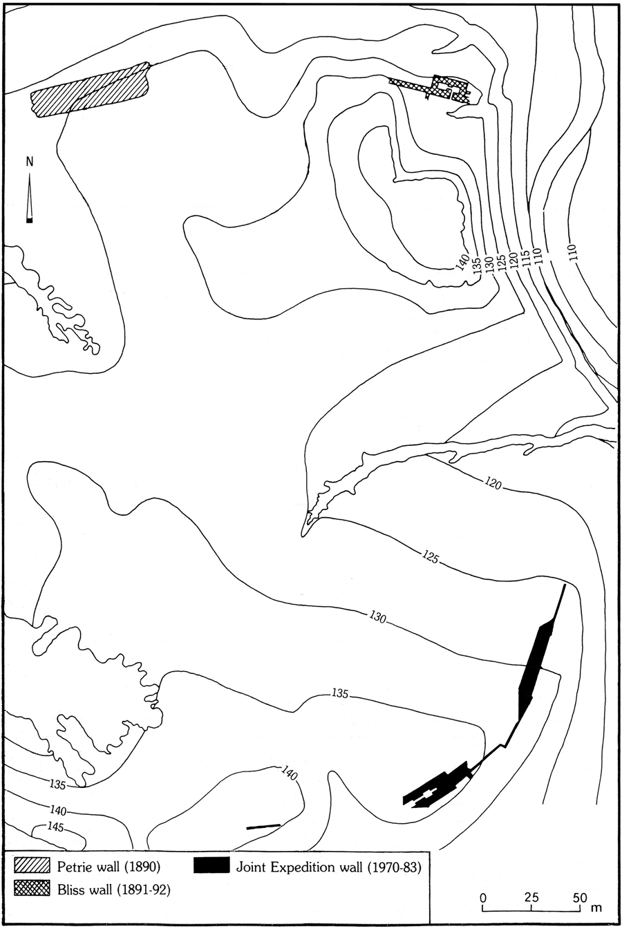
Tell el-Hesi (Fig. 7) is a 10 ha site positioned about 7 km south of the modern town of Qiryat Gat, southern Israel. It was only inhabited during the EB III, first as an unfortified site, and then as a site encircled by 6–10 m wide walls. Some of the wider sections of the fortifications were probably towers or bastions. A glacis reinforced the sandy slopes of the hill below the fortifications. The top of this glacis was flat, measuring up to 9 m in width. It may have served as a walkway to the site's spring. Other evidence of activities having taken place immediately outside the fortifications includes holes cut into the fortification wall and traces of ash and dung. This could indicate that shelters were built outside the wall (Doermann & Fargo Reference Doermann and Fargo1985; Fargo Reference Fargo and Stern1993; O'Connell & Rose Reference O'Connell and Rose1980, 84–9; Seger Reference Seger and de Miroschedji1989; Toombs Reference Toombs1983).
EB fortification at Tell el-Hesi. (After Fargo Reference Fargo and Stern1993.)

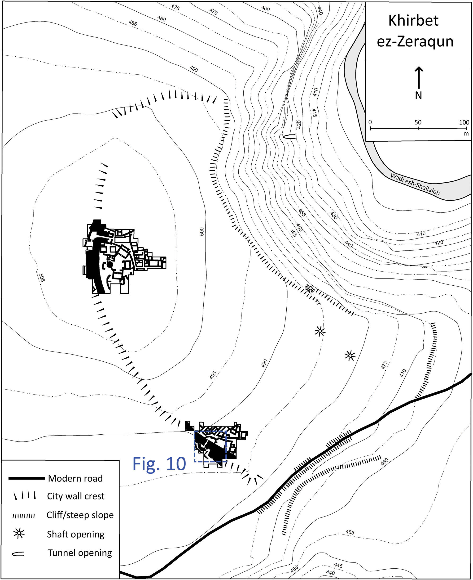
Khirbet ez-Zeraqun (Fig. 8) is an 8 ha site located on a hill northeast of Irbid, northern Jordan. It was founded as a fortified settlement during the EB II and appears to have been abandoned before the end of the EB III. Fortification walls were found along the northern and western sides of the site, while some further traces of it were uncovered along the southern side. No wall was found on the eastern side. Douglas (Reference Douglas and Chesson2011) proposed that this may be due to the possibility that the steep eastern slope either provided sufficient protection for the site, or alternatively that it encouraged the erosion of the fortifications on this side. Three stepped shafts led to the water table from inside the fortifications. Fortifications of the first phase (EB II) included a 3–4 m wide wall, one gate and six posterns on the acropolis and one gate and one postern in the lower town. During the EB III, the wall was widened to 6–7 m, the posterns were blocked and outer towers and bastions were added. The direct-access lower town gate went through several phases during which time it became a fortified indirect-access gate with an external tower. In its last phase the gate was blocked, and the entrance to the site was through a newly built ramp and stairs that led to a passageway located on top of the fortification wall (Douglas Reference Douglas and Chesson2011; Ibrahim & Mittmann Reference Ibrahim, Mittmann, Homès-Frederiq and Hennessy1989).
Khirbet ez-Zeraqun (blue square shows area enlarged in Figure 10). (After Douglas Reference Douglas and Chesson2011, fig. 2.)

Fortification analysis
Of the war-related criteria cited above, the most prominent feature found during the EB III is the period's fortifications. Since the EB III fortifications were based on already long-established ancient Near Eastern practices, they were analysed using conventional design rules (de la Croix Reference de la Croix1972; Keeley et al. Reference Keeley, Fontana and Quick2007). The following analysis shows that although the fortifications of the EBA in general and of the EB III in particular seem impressive and sophisticated, a closer look exposes their many tactical vulnerabilities.
Fortifications that did not encircle the whole site, extramural neighbourhoods
Three of the sites analysed (Tel Bet Yerah, Bab edh-Dhra’ and Zeraqun) were characterized by massive stone and mud-brick fortifications that included large walls and multiple towers, but were easily penetrable since their fortifications did not encircle the entire site. At Tel Bet Yerah the fortification walls flanked only the southern and western sides. On the other sides, where the site borders the Jordan River and the Sea of Galilee, no fortifications were found (Paz & Greenberg Reference Paz, Greenberg, Greenberg, Eisenberg, Paz and Paz2006). This means that the site was accessible from the sea and, since dried mud-brick structures cannot withstand water erosion, the site was also penetrable from the points where the fortification wall met the sea or the river. At Bab edh-Dhra’ no fortification wall was found on the steep northern side of the site (Rast & Schaub Reference Rast and Schaub2003; Schaub Reference Schaub and Stern1993). It may be missing due to erosion, but the preservation of EB domestic houses on this side (in excavation Fields XIV, XVII, XIX and especially XVI: see Figure 2; Rast & Schaub Reference Rast and Schaub2003, 286, fig. 10.1) precludes this explanation. The existence of dwellings along this slope also rules out the possibility that it was steep enough to prevent access. The extramural habitations located on other sides of the site may indicate that the site's inhabitants themselves did not consider the site's fortifications functionally protective. Zeraqun is another example of a site with no trace of fortifications on its steep eastern side, although no further evidence could be found for or against the hypothesis that the wall eroded on this side (Douglas Reference Douglas and Chesson2011). These sites may not be the only ones; recent research at Tel es-Safi shows it may also have had an extramural neighbourhood (Shai et al. Reference Shai, Chadwick, Welch, Katz, Greenfield and Maeir2016).
Fortifications and defensive features that fell out of use without being replaced
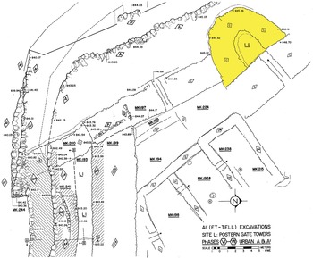
At several sites, segments of the fortifications were obliterated or went out of use without proper replacement, thus leaving the settlement exposed or vulnerable. At ‘Ai, the EB III fortification wall (Wall A) was built after the houses of Site (Area) C Phase VI became exposed to the outside. This was due to accumulations of fills eventually elevating them to a level higher than that of the older fortification wall (Wall B). Wall A not only incorporated internal towers, but was also built in front of the older fortifications (Wall C and B), and thus turned the older towers and bastions into internal ones (e.g. Wall C, Tower LII was blocked by Wall A; see highlighted area in Figure 9). This impeded their function as turrets preventing blind spots and allowing enfilading fire. It seems some of these towers went out of use altogether during this phase (Callaway Reference Callaway1980, 152–89; Marquet-Krause Reference Marquet-Krause1949).
‘Ai, Site L. (After Callaway Reference Callaway1980, fig. 98.)

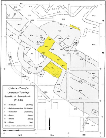
At Zeraqun, in the last stage of the fortifications (Phase 1), the lower town's main gate was blocked and a ramp and stairs (i9 and possibly i4: see highlighted areas in Fig. 10) were built leading to a passageway on top of the fortification wall (R16, W32, and W39 in Fig. 10) (Douglas Reference Douglas2007; Reference Douglas and Chesson2011). This, of course, contradicts every basic fortification design rule, as these stairs allowed easy scaling of the fortifications even without a ladder. Moreover, a passageway above a wall is much harder to block than a gate.
Zeraqun lower town gate in Phase 1. (After Douglas Reference Doermann and Fargo2007, Abb. 19.)

The site of Tel Bet Yerah may have stood virtually unfortified at the beginning of the EB III, after the EB II mudbrick wall (Wall A) ceased to function as an effective obstacle due to erosion and lack of maintenance and before the construction of Wall B (Paz & Greenberg Reference Paz, Greenberg, Greenberg, Eisenberg, Paz and Paz2006, 247).
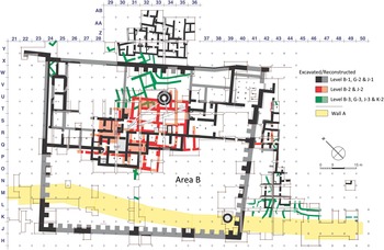
At Yarmuth, the internal Wall A with its many bastions was rendered ineffective by the construction of the towerless Wall B in front of it and Palace B-1 on top of it (Fig. 11). Unlike most EBA settlements, little effort was put into the town's fortifications during the EB III (Miroschedji Reference Miroschedji, Maeir and de Miroschedji2006, 70; Reference Miroschedji2013). This is bewildering, since Palace B-1, with its large storerooms full of surplus (Miroschedji Reference Miroschedji and Stern2008), would have made the settlement much more attractive to attackers, thus requiring an even greater level of protection than before.
Location of Yarmuth Palace B-1 (black and grey walls) over Wall A (yellow). (After Miroschedji Reference Miroschedji2013, fig. 12.)

Features positioned in locations that made fortifications less effective
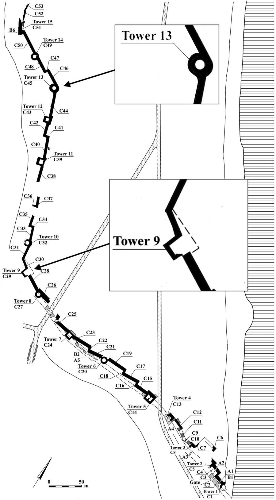
As Greenberg and Paz noted (Reference Greenberg and Paz2005, 94), Wall C at Tel Bet Yerah ‘exhibits a curious combination of planned military engineering and ad hoc construction’, but even the ‘planned military engineering’ upon close scrutiny shows its many weak points. Many towers were incorporated into the site's fortification wall. But, when analysing their positions along the wall, it seems that they were not always placed in the most tactical of locations: Tower 13 is positioned in the most concave section of the wall, where its defenders would have needed to contend with the worst firing angles found along the wall's length. Tower 9 is positioned about 20 m south of the best possible location at the corner of the wall, where its garrison would have had a firing and viewing angle of about 220 degrees and a commanding view of large sections of the wall to the north and south (Fig. 12).
Tel Bet Yerah fortifications. Note inferior positions of Towers 9 and 13 (Walls A & B shaded grey, Wall C in black, modern roads dotted, Sea of Galilee hatched). (After Paz & Greenberg Reference Paz, Greenberg, Greenberg, Eisenberg, Paz and Paz2006, plan 6.1.)

Gaps between towers at Tel Bet Yerah were between 36 and 129 m in length, with an average of 56.7 m (excluding the exceptional value of 129 m). Almost all of the gaps are larger than the traditional 25–40 m ‘bow shot’ gap (Keeley et al. Reference Keeley, Fontana and Quick2007, 72; Yadin Reference Yadin1963, 19–20), which allows for covering fire over all sections of the wall as well as over the other towers (should they be scaled by the enemy).
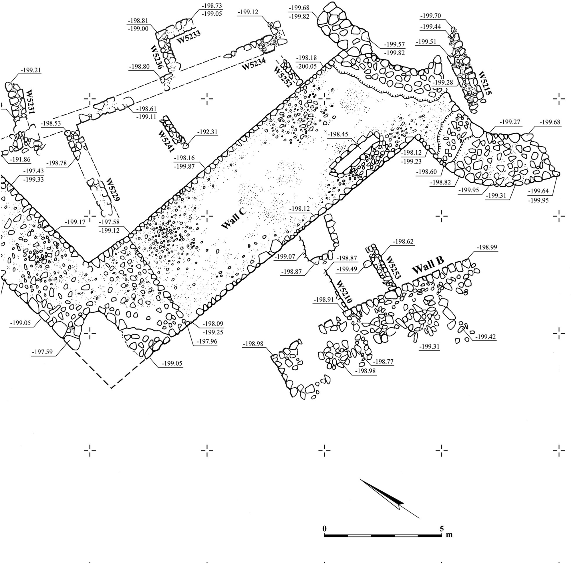
Some segments of Wall C were positioned on inferior lower ground, with the remains of Wall B, built at the beginning of EB III, creating a pile just a few metres in front of it. This decreased the defensive value of Wall C (Figs 12 & 13).
Wall C of Tel Bet Yerah with older Wall B in front of it (wall section near Tower 1, Area BS, Local Str. 8). (After Greenberg & Eisenberg Reference Greenberg, Eisenberg, Greenberg, Eisenberg, Paz and Paz2006, plan 5.11.)

In addition to Wall A at ‘Ai, which was built with internal towers (see above), another case of internal bastions was found at Tel Yarmuth, where several internal bastions were built on the west side of the site, after Wall A went out of use (Fig. 14: Phase 3 ‘Platforms’). As discussed above, internal bastions and towers are much less effective than protruding ones.
Three phases of fortifications on the west side of Yarmuth. (After Miroschedji Reference Miroschedji2018a, fig. 2.)
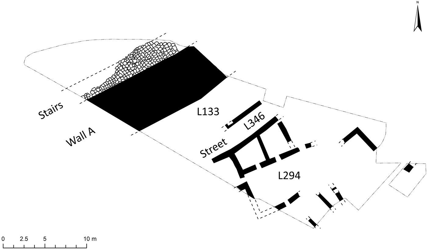
At Tell el-Hesi, a flat surface was found on the upper part of the glacis alongside the base of the fortification wall. It may have been used as a walkway to the local spring (Doermann & Fargo Reference Doermann and Fargo1985, 16–17). It would also have allowed for the easy positioning of scaling ladders or other siege engines near the fortification wall and nullified any function of the glacis as a feature preventing such siege tactics; therefore, it appears that the role of the glacis at this site was solely towards reinforcing its sandy slopes. At Hebron, a staircase was built in a similar fashion, next to the outer side of the fortification wall (Wall A) (Eisenberg Reference Eisenberg, Aviram, Gitin, Mazar, Na'aman, Stern and Zuckerman2011). The staircase would have made scaling the wall easier, limiting its effectiveness as a defensive structure (see top left of Figure 15).
Staircase outside the fortification wall of Hebron. (After Eisenberg Reference Eisenberg, Aviram, Gitin, Mazar, Na'aman, Stern and Zuckerman2011, fig. 9.)

Absence of protected water sources
To date, the only water system identified at an EB site was found within the walls of Zeraqun, and was comprised of three stepped shafts leading to the water table (Ibrahim & Mittmann Reference Ibrahim, Mittmann, Homès-Frederiq and Hennessy1989). Excavations at ‘Ai and EB II Arad found structures that may be identified as open water reservoirs (Amiran & Ilan Reference Amiran and Ilan1996, 105–27, pls. 96, 97; Callaway Reference Callaway and Stern1993), but their effectiveness is limited due to the area's hot summers. Even Tel Bet Yerah, though located next to the Jordan River, does not have an accessible drinking water source next to it. Most of the EB sites analysed above do not have a readily available and secure water source, and were therefore vulnerable to siege warfare.
Site location
Many sites were not necessarily positioned in the best tactical location. The site of Hebron, for example, was established on a spur on the eastern side of Jebel Rumeida. It is situated in a tactically inferior position, as it is dominated by the higher ground of this mountain (Eisenberg Reference Eisenberg, Aviram, Gitin, Mazar, Na'aman, Stern and Zuckerman2011; Ofer Reference Ofer and Stern1993). Other sites have limited access to water (see above). Evidence for this shortcoming can be derived from the fact that almost all of the sites analysed here were deserted at the end of the EBA, never to be inhabited again. This is in stark contrast to the Near Eastern ‘tel culture’ wherein better locations were settled over and over again.
Long walls and insufficient manpower for effective defence
In order to allow for a smaller garrison and better communication between a city's defenders, an effective fortification wall should be as short as possible. The best way to achieve this is to have a dense and compact settlement, surrounded by a circular fortification wall. EBA towns were different; many of them sprawled over large tracts of land, considerable parts of which were not settled. The houses were not compact, with open courtyards constituting a considerable portion of the built area, e.g. at Tel Yarmuth (Miroschedji Reference de Miroschedji1999, 7) or at EB II Arad (Amiran & Ilan Reference Amiran and Ilan1996). At Tel Bet Yerah, Wall C delineated a large area that may have been sparsely inhabited (Greenberg & Paz Reference Greenberg, Paz and Greenberg2014). Leviah’ (Fig. 4) was located in an easily defended location, but the elongated shape of the settlement resulted in fortifications that were very long (1900 m) in relation to the limited area (9 ha) that they encircled. Had Leviah’ been a circular settlement, the total length of its wall would have been 1063 m. All of this presents an image of the EBA as a period with large settlements, encircled by long walls, but with relatively small populations who were unable to supply the garrison required to protect them.
Gates
In contrast to the EB II, with its multiple simple direct-access gates, during the EB III there were only one or two gates in every settlement. Many gates and passages of the previous period were blocked, while some became indirect-access gates. This may be another indication of the rise of threats or fear of violence during this period. A closer look reveals that while some gates were elaborate, they were not as functional as may seem. This is demonstrated at Yarmuth (Fig. 16) with its left-approach Gate E (in contrast to the expected right-approach gate that leaves the attackers’ unshielded right side exposed to the defenders), and at Zeraqun where the complex right-approach gate was turned into a gate positioned upon the fortification wall (see above). Other settlements described here either kept their direct-access gates, or the data is insufficient and no conclusions can be drawn.
Left access Gate E at Yarmuth. (After Miroschedji Reference Miroschedji2013, fig. 10.)

Constant re-building
Though the constant re-building of the fortifications may be further proof of a persistent state of warfare (e.g. Helms Reference Helms1976), it otherwise begs the question of why else the inhabitants would need repeatedly to renew and repair their city walls. An alternative explanation for this phenomenon could be a lack of maintenance; for instance at Tel Bet Yerah, by the time Wall B was built, Wall A was heavily deteriorated to such a degree that the site may have been essentially unfortified (Paz & Greenberg Reference Paz, Greenberg, Greenberg, Eisenberg, Paz and Paz2006). In one instance, houses at ‘Ai's Site C were higher than Wall B due to sediment accumulation on its internal side, eventually necessitating the construction of Wall A (Callaway Reference Callaway1980, 155). Yarmuth Wall A went out of use at some point and the above-mentioned internal bastions were built as a substitute (Miroschedji Reference Miroschedji2013). For those living in a constant state of war, fortifications were indispensable and would have been restored before they went out of use. The neglect noted above indicates that their importance was not as great as has previously been suggested.
Cost of construction
Construction cost estimationsFootnote 2 show that the construction of fortifications demanded a considerable amount of effort on the part of the local population. However, even if one assumes that the rate of participation was low and the work was done only during lull months, such a task could be completed within a few years, especially when working with mud-brick walls.
Available weapons and siege engines
In order to scale or breach a fortification, it is necessary to disable the defenders’ topographic superiority. This is done by firing long-range projectiles that drive the defenders away from the top of the fortification wall. Long-range projectiles are absent from the archaeological record of the area during this period; flint arrowheads and microlithic lunates are rare in the EBA and were found only in the Negev desert, southern trans-Jordan and the Sinai desert at sites dated to the EB I and II (Rosen Reference Rosen and de Miroschedji1989, 204–6), where no fortified settlements exist. There is a total absence of any type of chipped stone points in the sown areas of the EBA Levant (Rosen Reference Rosen and Maczynska2014). Wooden arrowheads, which usually do not leave traces in the archaeological record, may have been used, but this is less reasonable since they are less effective as a weapon (Guthrie Reference Guthrie, Clutton-Brock and Grigson1983; Pope Reference Pope1962, 56), especially when compared to the flint points that were still in use in the adjacent arid areas.
The sling may be used as an effective long-range weapon (Lee Reference Lee, Freeman and Pollard2001; Robertson Reference Robertson2016), but in order for it to be effective in warfare it should be used by large and organized units of slingers concentrating their firepower. This was not the case in the southern Levantine EBA, where no caches or any other clear presence of sling stones were found in destruction layers. The only claimed evidence of sling stones found in a destruction layer is at Leviah’, where hundreds of pebbles, identified as sling stones, were excavated from a destruction layer around the gate (Paz Reference Paz2011, 9–11). However, this evidence is debatable since these pebbles are embedded within the destruction layer debris and are not lying on the surrounding surfaces and floors, as would be expected. Moreover, some of these pebbles seem to be fairly heavy, with weights of up to 300 g, which would not be a slinger's natural choice (Vutiropulos Reference Vutiropulos1991, 279).
The only apparent anti-human weapons of the period are stone maceheads, which were usually piriform or sphere-shaped. The effectiveness of these weapons is doubtful due to their narrow shaft holes that did not allow for thick and sturdy handles, while their rounded forms are much less lethal than the sharp-edged variety, such as disk-shaped maceheads (Fischer Reference Fischer2008, 359–60; Shimelmitz & Rosenberg Reference Shimelmitz and Rosenberg2013). Furthermore, maceheads are close-range weapons and were definitely not suited for siege or wall-scaling warfare. It is arguable that they were more of a symbolic item than a real weapon.
There is no evidence in the EBA of the southern Levant for siege engines such as siege towers or battering rams, nor for the use of siege tactics like sapping or tunnelling. The first evidence for the use of these comes from other areas (Mesopotamia and Egypt) and is dated to 2500–2400 bc (Burke Reference Burke2004, 74, 91; Humble Reference Humble1980, 13; Paz Reference Paz2011; Yadin Reference Yadin1963, 146–7), the very end of the southern Levantine EB III.
Settlement pattern
Settlement patterns may provide some evidence for the existence of endemic warfare during the latter stages of the EBA; during EB II and EB III, populations tended to concentrate in the larger fortified settlements, while many of the smaller ones became deserted (Finkelstein & Gophna Reference Finkelstein and Gophna1993; Getzov et al. Reference Getzov, Paz and Gophna2001; Gophna Reference Gophna and Levy1995; Greenberg Reference Greenberg2002; Reference Greenberg2003; Harrison Reference Harrison1997). This geographic pattern, in which gaps between settlements occur without being instigated by the environment, is usually attributed to enduring conflict.
Archaeological evidence of violence
Destructions
It seems that destruction layers are not a common phenomenon during the EBA, and especially the EB III. Most of the clear destruction layers are dated to EB I (Schaub Reference Schaub2007), and at least some of them can be attributed to seismic activities (e.g. Coogan Reference Coogan1984). Clear evidence in the form of frequent destruction layers and site abandonments was not found, and many of the sites were peacefully abandoned at the end of the period (e.g. Tel Bet Yerah, Yarmuth).
Skeletal and mortuary data
Another missing piece of evidence is skeletal data. Overall, mortuary data is lacking for EB II and III, and hardly any contemporary cemeteries were found. The only place where such evidence was found is at the Bab adh-Dhra’ cemetery. An analysis of this cemetery revealed no real evidence for an intensification of violence during the latter stages of the EBA, when the site grew larger and its fortifications were built (Gasperetti & Sheridan Reference Gasperetti and Sheridan2013).
Discussion
The EB III sites discussed above were walled by elaborate and massive fortification systems that incorporated sophisticated features and would have involved heavy investments in their construction. Looking behind the impressive façade, a close inspection shows that these impressive features did not amount to a very efficient military defence, and in some cases were almost useless. The fortifications of sites like ‘Ai, Hebron, Tel Bet Yerah, Tel Yarmuth, Tell el-Hesi and Zeraqun were not efficient due to internal towers and bastions, walls and other features that went out of use or were cancelled without replacement, external stairs or pathways that facilitated scaling, or towers and walls located in inferior locations. Bab edh-Dhra’, Tel Bet Yerah and possibly Zeraqun were only partially encircled by their fortifications, making these sites extremely vulnerable. Almost all of the sites did not have a secure water source, which made them vulnerable to siege warfare. The lower functionality of these fortifications was not the result of a lack of knowledge; as noted above, fully functional fortifications appeared in Mesopotamia several centuries prior to the southern Levantine EB III and the knowledge for their construction was passed on by itinerant artisans.
Another important argument against the existence of high levels of conflict is the lack of long-range weapons. Without these weapons providing covering fire, there is no way of scaling or breaching fortifications. With no long-range weapons and no siege engines, there is no need for building thick and high fortification walls.
The settlement pattern during the EB III, when disparate populations became concentrated into fewer large settlements, may be a positive marker of intercommunal conflict. However, looking at the succeeding period, the Intermediate Bronze Age (IBA), we can see that a specific settlement pattern may not be a direct indication of war: during the IBA there is a plethora of evidence for violence in the form of elaborate metal weapons and warrior burials, albeit within a settlement pattern characterized by small and unfortified settlements. It therefore seems that settlement pattern may be an ambiguous piece of evidence that does not necessarily indicate (or refute) the presence of endemic warfare. A similar situation was identified in the Iberian Peninsula (Oosterbeek Reference Oosterbeek and Carman1997).
Other criteria that also point to a low level of violent conflict include the inferior locations of the sites, meagre skeletal data, lack of destruction layers, no artistic representations and a general lack of weapons.
The constant re-building of fortifications during EB III is an ambiguous piece of evidence. It can be interpreted as a sign of conflict, but it can also be the outcome of neglect; after their construction, the mud-brick fortifications were left unmaintained until a major renovation was needed. This means that for long periods of time, the fortifications were not necessary and were sometimes neglected to the point of complete deterioration.
The costs involved in the construction of the fortifications were high, but not exaggerated—walls made mainly of mud-bricks could be finished within a few years by the town population alone.
When analysing each piece of evidence by itself, the picture may seem ambiguous; Hebron was founded on an inferior location and the inhabitants preferred to defend this location instead of moving to a better one; the slopes of Zeraqun or the lake and river at Tel Bet Yerah seemed to provide enough protection, especially when considering the high costs involved in building a long fortification wall. But, when looking at the bulk of evidence, the picture is much clearer—there are too many deficiencies in the fortifications, they were neglected and undermaintained, there was a lack of weapons in general and long-range ones in particular, and there is a lack of other types of evidence. Even the decisions taken at Zeraqun and Tel Bet Yerah seem perplexing, since the inhabitants chose to build and re-build thick and elaborate fortifications on one side while leaving the other sides unfortified, instead of building a less elaborate wall that would have encircled the entire settlement.Footnote 3
Considering all of the above leads to the conclusion that the investments in elaborate fortifications during EB III did not match the existing threat and that the reasons for building them were not necessarily connected with defence.
The possible roles of fortifications
The fortifications built at the end of the Early Bronze Age are a clear example of effort exceeding functionality: large investments in raw material and manpower led to the construction of elaborate but not very functional fortifications. As evidence of endemic warfare is meagre, other functions should be considered. These include: (1) boundary markers; (2) control of traffic and populations; (3) an image and symbol of the settlement; (4) a demonstration of power, showing the settlement's strength and success, in order to deter enemies; and (5) unification of the population around a common project.
In order for a wall to serve as a boundary marker or to control incoming and outgoing traffic, a low and unelaborate fortification wall would have been enough. If the fortification wall was to be a symbol of the settlement, it should be large, whereas the actual efficiency is less important. In order to demonstrate power, a fortification wall should look powerful and commanding. Additional defensive features like defended gates, towers, and bastions would add to its impact.
The size and elaboration of the EB III walls, together with their low functionality, suggest that one of their main aims was to demonstrate power and deter enemies, and that they were not intended to actually stand in the face of concerted attacks or sieges. Since the power-demonstration function could have been achieved with less effort (i.e. less elaborate walls), other reasons must have existed. The neglect and constant construction of new walls indicate that the process of construction itself was important, possibly more important than other functions, and definitely more important than the maintenance of these large structures. The careful planning and construction of the fortification walls mean that there must have been people who initiated, planned and directed these large projects. The above observations regarding the exaggerated elaboration of these fortifications lead to the conclusion that these ‘managers’ initiated these projects not only to protect the settlements, but also in order to aggrandize themselves, either through the construction process itself or as being the ‘protectors’ of the settlement (as in Kantner Reference Kantner, Vaughn, Eerkens and Kantner2009, 263; or Spence Reference Spence2004, 271). It is not unthinkable that these people also overstated threats in order to persuade the population into building massive fortification walls in a period where the only real weapons were thin-bored maceheads.
Conclusions
The large, elaborate and less-than-functional fortifications of the EB III, together with the lack of long-range weapons, siege engines, siege tactics, and other evidence of large-scale warfare lead to the inevitable conclusion that, while violent conflicts did occur during this period, their scale and sophistication were low. The EBA fortifications were large and impressive in order to deter potential attackers, but their elaboration was not commensurate with the existing threats, and as such this paper argues that social factors were the main causes of this over-investment. The repeated rebuilding of walls hints that the construction process was more important than their maintenance; it seems that the community was anxious to build large walls, but did not care how effective they were. They also left them to deteriorate until the initiation of another ‘surge’ of construction. This may indicate that there were forces external to the public that had a special interest in building these walls. The obvious ‘candidates’ for this ‘role’ would be incipient leaders or elites that coordinated these large projects. During the EBA in general, and EB III in particular, there is no extensive evidence of elites (except for Yarmuth palace B-1, the plausible palace at Megiddo, and some prestige items), but identifying incipient leaders in transitory societies was never easy. The scale of the fortifications, taken together with their major deficiencies, indicates that they were mainly built to deter enemies with their sheer size, rather than serve as a real obstacle. The magnitude of the fortifications in relation to their actual functionality and in light of their subsequent neglect may hint that the external threats were used by these incipient leaders (either groups or individuals) to consolidate the society, and to ‘fortify’ their own status.
Acknowledgements
I would like to thank Prof. Raphael Greenberg for his dedicated supervision of my PhD (on which this article is based) and Mark Cavanagh for meticulously editing this article. I would also like to thank the editor John Robb and the anonymous reviewers for their remarks that significantly improved this paper, helped to broaden its scope, and made it accessible to a larger audience.