INTRODUCTION
The hyperarid Atacama Desert is the driest place on Earth and it has likely maintained a semi-continuously hyperarid climate for millions of years (Hartley and Chong, Reference Hartley and Chong2002; Amundson et al., Reference Amundson, Dietrich, Bellugi, Ewing, Nishiizumi, Chong and Owen2012; Jordan et al., Reference Jordan, Kirk-Lawlor, Blanco, Rech and Cosentino2014). Climate records reconstructed from proxy data suggest increased moisture during the late Pleistocene and progressively drier conditions in the Holocene. Middens, wetlands, and stream activity in northern Chile have been used to reconstruct significant regional late Quaternary wet periods from 17.5–14.2 ka and 13.8–9.7 ka, known as Central Andean Pluvial Events (CAPE; Rech et al., Reference Rech, Quade and Betancourt2002; Nester et al., Reference Nester, Gayo, Latorre, Jordan and Blanco2007; Quade et al., Reference Quade, Rech, Betancourt, Latorre, Quade, Rylander and Fisher2008; Gayo et al., Reference Gayo, Latorre, Jordan, Nester, Estay, Ojeda and Santoro2012). Similarly, the occurrence of mollusks in the hyperarid region of southern Peru indicates more humid conditions in the late Pleistocene (Mächtle et al., Reference Mächtle, Unkel, Eitel, Kromer and Schiegl2010). Latorre et al. (2011) have suggested that dune deposits in the region may retain records of past climate change, specifically fog intensity. A detailed understanding of the region’s climate history is still lacking, however, and additional records are desirable to fully understand the climatic, ecological, and anthropological history of the region.
One of the unique local climate characteristics of this area is the strong and persistent on-shore winds that have sculpted the landscapes in the Llamara Basin and its periphery (Flores-Aqueveque et al., Reference Flores-Aqueveque, Alfaro, Caquineau, Foret, Vargas and Rutllant2012). Within what is largely a deflationary landscape, we found sand dunes that have accumulated in depressions of a highly undulating outcrop of Miocene anhydrite and halite. In this study, we investigated these previously unrecognized deposits to determine whether they accumulate continuously or episodically, and if they preserve a record of environmental change. In addition, we considered the mechanisms that have contributed to the formation of the dunes, and how physical and chemical changes in the sediment may reflect regional environmental changes.
METHODS
Site description and sample collection
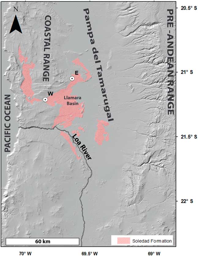
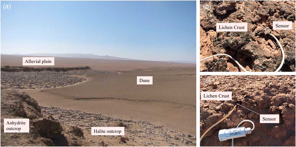
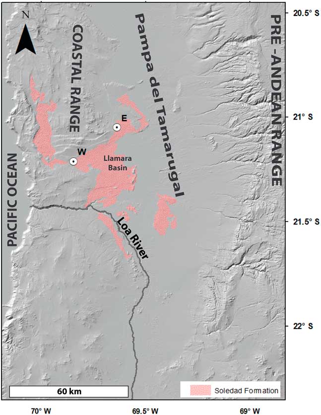
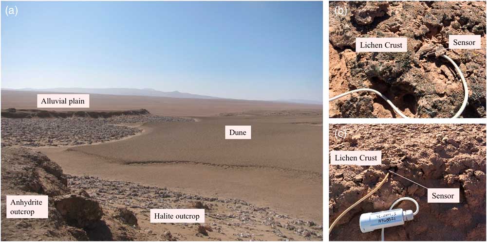
Two study sites were chosen within the Llamara Basin, a subsection of the endorheic basin of Pampa del Tamarugal. The Llamara Basin is a large semi-enclosed basin that has, over geological time, contained lakes, wetlands, and/or salt accumulations from the evaporation of waters derived from the Andes (Saez et al., Reference Sáez, Cabrera, Jensen and Chong1999; Fig. 1). The various sedimentary outcrops in the Llamara Basin range in age from Miocene to early Holocene. The deposits examined here immediately overlie a Miocene outcrop known as the Soledad Formation. The Soledad Formation is characterized by a several-meter-thick anhydrite (calcium sulfate) cap that overlies many meters of nearly pure halite (sodium chloride; Pueyo et al., Reference Pueyo, Chong and Jensen2001). Locally, the anhydrite cap is discontinuous (likely due to aeolian and water erosion), leading to a badland-like topography with closed depressions several meters deep and tens of meters in diameter. In our field area, many of these depressions have been partially infilled with a meter or more of sand. The dunes are now capped by a thin and distinctive lichen-bearing crust in many of these locations (Fig. 2).
(color online) Location of sites within the Soledad Formation, a sedimentary deposit within the Llamara Basin.
(color online) (a) Landscape of the Soledad Formation demonstrating the rugged terrain and eroded basins now containing sand dunes. Appearance of surface crusts at (b) the west site and (c) east site and installation of temperature and relative humidity sensors.
The two sites are located along a west-to-east transect on the northern edge of the Soledad Formation at 835 and 895 m above sea level (m asl), and approximately 25 km and 50 km from the Pacific coast (Fig. 1). Both sites experience frequent and strong onshore winds that often bring marine fog. The strong winds clearly result in significant deflation of the regional landscape, creating features such as inverted stream channels, and in other areas (particularly around perennial shrubs and trees), sediment is deposited as coppice dunes (Williams et al., Reference Williams, Chuang and Berman2017).
In June 2013, one sand dune at each site was hand excavated, and the stratigraphic and pedogenic features were logged and described using standard soil field procedures (Soil Survey Staff, 1999). Samples of each visually observable horizon/strata were collected and transported to the lab in Ziploc bags.
Environmental monitoring
Decagon Devices leaf wetness sensors, Davis cup anemometers, and total solar radiation sensors were used to monitor meteorological conditions at both sites. The leaf wetness sensors were installed as a proxy measurement for fog and dew accumulation (Burgess and Dawson, Reference Burgess and Dawson2004). Because it did not rain during the year of study, we have assumed that any “wetness” events recorded by the leaf wetness sensors resulted from dew or fog. A value of 460 counts was chosen as the threshold to report wetness, which, according to the manufacturer, is a conservative value. In addition, Onset HOBO Pro v2 (U23-002) temperature and relative humidity sensors were carefully installed beneath sections of lichen crust at each site (Fig. 2). Two sensors were installed at the east site and four sensors were installed at the west site. For all of the sensors, hourly monitoring began June 2013 and ran continuously for 13 months.
Soil chemical and physical characterization
A particle size analysis was performed on each sediment horizon using the hydrometer method outlined by Gee and Bauder (Reference Gee and Bauder1986). Briefly, excess salt was removed prior to analysis by washing samples with deionized water, and then 30 g of dried sample was dispersed in 100 mL of 5% sodium hexametaphosphate solution by shaking for 16 hours on a horizontal shaker. The suspension was transferred to a sedimentation cylinder and deionized water added to reach 1 L. Contents of the cylinder were mixed thoroughly before the first reading. Readings of each sample and a blank solution were taken at 0.5, 1, 3, 10, 30, 60, 90, 120, and 1440 minutes using the hydrometer. Temperature readings were also taken at each time point.
X-ray diffraction analysis was made on a PANalytical X’Pert Pro diffractometer equipped with a cobalt x-ray tube and X’Celerator detector in the department of Earth and Planetary Science at University of California, Berkeley. Dried samples were prepared for analysis by loading into glass well plates. The material was pressed flat using a glass slide. Each sample was run for 25 minutes.
Sulfate stable isotope ratios
Sulfur stable isotope ratio analysis was performed in the Laboratory for Environmental and Sedimentary Isotope Geochemistry at the Department of Earth and Planetary Science, University of California, Berkeley, following the protocol outlined in Michalski et al. (Reference Michalski, Bohlke and Thiemens2004). Soil sulfate was dissolved in water by shaking pulverized soil for 4 hours in 45 mL deionized water. The mass of soil ranged from 80 to 3000 mg, the sizes needed to precipitate ~100 mg of BaSO4 (based on the total sulfur content of each sample). The sediment was then removed by filtering samples through 0.2 µm filter paper. The sulfate was precipitated as BaSO4 by adding 5 mL 1 M BaCl2 to the solution while samples were in a warm water bath (55°C) under a standard laboratory fume hood. BaSO4 was allowed to precipitate overnight. Samples were then centrifuged at 4000 rpm for 20 minutes and the supernatant was discarded. Precipitated BaSO4 was then dried at 65°C overnight. Approximately 50–200 µg of the BaSO4 sample was analyzed in duplicate on a GV Isoprime isotope ratio mass spectrometer and a Eurovector Elemental Analyzer (EuroEA3028-HT). The analytical precision of the measurement is better than 0.2‰. Values are reported as δ34S relative to Canyon Diablo Troilite (CDT).
Radiocarbon measurements
Bulk soil samples were prepared for radiocarbon analysis by first removing inorganic carbon and excess salts. Five g of pulverized soil was soaked in 0.5 M HCl for 24 hours with intermittent shaking to agitate the solution, followed by centrifuging and decanting the acidic solution. To ensure complete removal of HCl, the samples underwent alternating soaking and shaking in deionized water for 24 hours, then they were centrifuged and the supernatant discarded. This washing process with deionized water was repeated twice before samples were dried at 60°C.
Radiocarbon analysis was performed on the Van de Graaff FN accelerator mass spectrometer (AMS) at the Center for Accelerator Mass Spectrometry at Lawrence Livermore National Laboratory, Livermore, California. Approximately 0.5 g of washed sample was prepared for 14C measurement by sealed-tube combustion to CO2 in the presence of CuO and Ag, and then reduced into iron powder in the presence of H2 at 570°C (Vogel et al., Reference Vogel, Southon, Nelson and Brown1984). Aliquots of the CO2 were analyzed for δ13C at the Department of Geological Sciences Stable Isotope Laboratory, University of California Davis (GVI Optima Stable Isotope Ratio Mass Spectrometer). Measured δ13C values were used to correct for mass-dependent fractionation. The AMS precision was 3‰. Radiocarbon ages were calibrated to calendar year BP using the CALIBomb online program (http://calib.qub.ac.uk/CALIBomb/) with the southern hemisphere dataset SH_CAL13 (Hogg et al., Reference Hogg, Hua, Blackwell, Niu, Buck, Guilderson and Heaton2013) and the 2-sigma probability range is reported. A smoothing of 50 yr was used to account for the gradual growth of lichen and accumulation of organic carbon.
Total fatty acid extraction and GC-IRMS analysis
Fatty acid extraction, esterification, and analysis were performed at the Jet Propulsion Laboratory Astrobiogeochemistry Laboratory (abcLab). Total fatty acids were extracted from the soils and esterified to produce fatty acid methyl esters (FAMEs) following the method developed by Graber and Tsechansky (Reference Graber and Tsechansky2010) with a few modifications. Excess salts were first removed from samples from the east site by shaking samples in 250 mL ultrapure (Type 1) water for 4 hours, then the samples were centrifuged and the supernatant discarded. Four g of dried, sieved, and pulverized soil samples were placed in a Teflon tube with NaSO4 added as a desiccant. Six mL of 5% methanolic HCl and 6 mL of toluene were added, the samples vortexed, and then placed in an oven at 60°C overnight. The following day, 15 mL of 5% NaCl solution was added, the samples vortexed, and then centrifuged for 40 minutes at 3000 rpm. The upper organic-bearing phase was pipetted into a new tube and 15 mL of a 2% KHCO3 solution was added. The samples were gently shaken for 2 minutes and then centrifuged for 30 minutes at 3000 rpm. The upper organic-bearing phase was extracted by pipetting and passed over a NaSO4 column then a Si gel column. Samples were dried in a stream of N2 gas and then stored in the freezer at -20°C until analysis. Prior to analysis by GC-MS, samples from the west site were mixed with 100 µL 1:1 n-hexane:MTBE solution and samples from the east site mixed with 50 µL 1:1 n-hexane:MTBE solution to account for differences in FAME concentration. A procedural blank (pure SiO2 sand baked at 850°C for 24 hours) was processed with every five unknown samples.
FAME samples were analyzed by GC-MS using a Thermo Trace Ultra GC and ISQ mass spectrometer. The GC was fitted with a 30 m DB-23 column (Agilent 122-2362) using helium as the carrier gas at a constant flow rate of 1 mL/min. The ISQ source was operated at 250°C in EI-mode at 70 eV ionization energy. One µL of sample was injected into a split/splitless injector in splitless mode at 250°C. The GC oven program started at 50°C for two minutes, ramped to 180°C at 15°C/minute, then ramped to 240°C at 10°C/minute and held for 15 minutes. Samples were run in duplicate accompanied by the procedural blanks. The Supelco 37 Component FAME Mix (CRM47885) was injected at least once daily to monitor GC performance and identify FAMEs.
In order to determine the δ2H of stearic and palmitic acid methyl esters, samples were reanalyzed (also in duplicate) using a Thermo Delta V Plus isotope ratio mass spectrometer coupled to the Trace Ultra GC via a Thermo IsoLink. Analytical conditions were the same as described above except that a fraction of the sample was pyrolized at 1420°C in the IsoLink after eluting from the GC column and was then introduced into the Delta V Plus. Duplicate analyses of Fatty Acid Ester Mixture F8-3 (University of Indiana Isotope Lab) were used to normalize δ2H values relative to VSMOW. The mean difference between duplicate samples was <4‰. The H3 factor was determined prior to each day’s analyses (n=10) and had a mean value of 5.04 ± 0.13 (1 SD).
RESULTS AND DISCUSSION
Present day meteorological conditions
Leaf wetness sensors were used to measure the present-day differences in fog and dew between the two sites. The data clearly show that the west site receives more intense and frequent fog events. Over the 13 months of recording, the west site had liquid moisture present for 3109 hours, and the east site for 1181 hours, out of 9504 total hours. This is equivalent to the presence of dew ~32% and ~12% of the year at the west and east sites, respectively. The difference in fog occurrence correlates with distance to the coast and elevation, with the western site being ~25 km closer to the coast and 60 m lower in elevation.
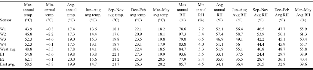
Monitoring of the temperature and relative humidity under the surface crust revealed that the west site maintains a higher relative humidity than the east site (Table 1). The average annual relative humidity at the west site was 1.5 times greater than the eastern one (52% versus 34%). This difference in average relative humidity is consistent throughout all seasons, reflecting the different fog frequencies. The average temperature beneath the crust at the western site was 18°C, and 20°C at the east. The eastern site also has greater temperature extremes, both 10°C warmer and 2.5°C cooler than extremes at the western site.
Temperature and relative humidity data recorded using Onset HOBO® Pro v2 (U23-002) sensors installed beneath the surface crust (Fig. 2b and c).

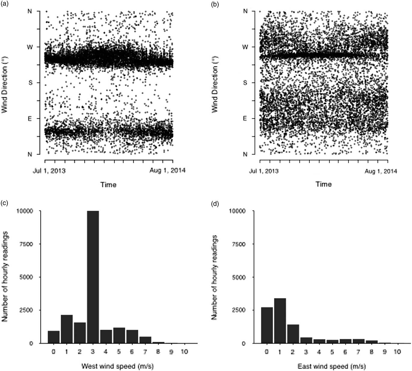
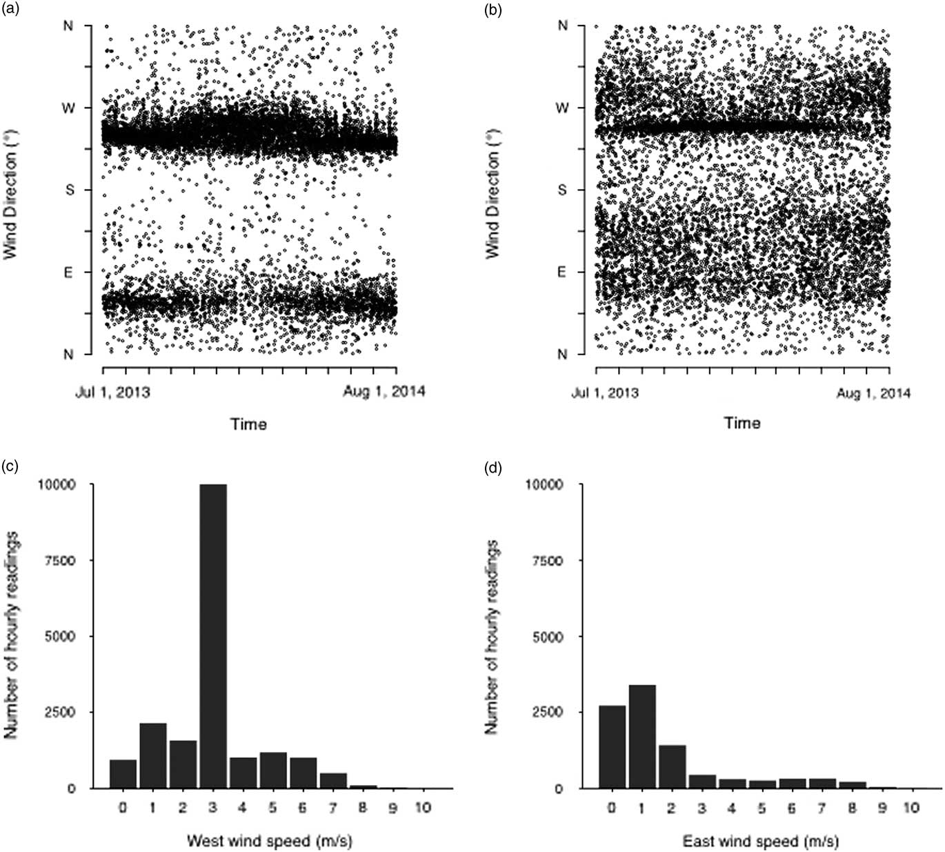
The anemometers showed that the wind direction was southwest or northeast, and that the western site regularly experiences higher speeds. On average, the wind speeds were 3 m s−1 and 1.7 m s−1 at the west and east sites, respectively. Both sites experience gusts as high as 11.5 m s−1 (Fig. 3).
Hourly measurements of wind speed and direction were taken for 13 months beginning in June 2013. Each point represents the wind direction at a single time at the (a) west site and (b) east site. Frequency and range of wind speeds at the (c) west site and (d) east site.
Location and source of sand dunes
It is increasingly recognized that arid landscapes are complex mosaics of areas impacted by both aeolian deflation and deposition. For example, in the southwestern United States, deflation of exposed playas and stream beds generates dust that accumulates on surrounding landscapes as an aeolian mantle (V horizon) over underlying soils (Turk and Graham, Reference Turk and Graham2011). The Llamara Basin in Chile represents a similar, but more extreme, version of these processes that appear to operate in many deserts.
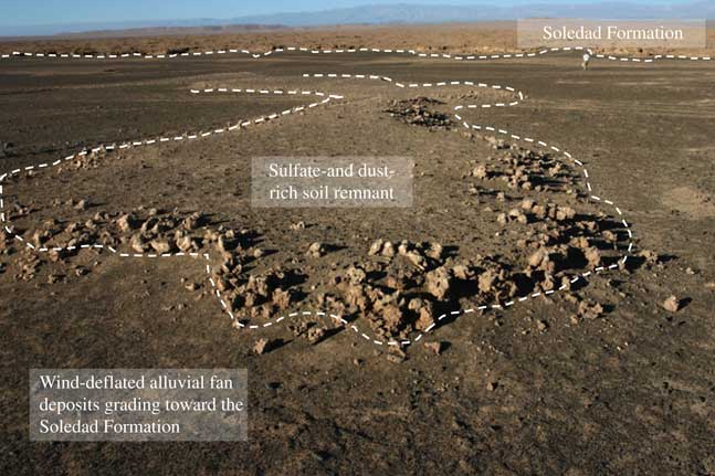
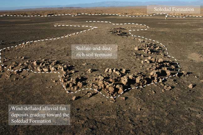
At the edge of the Soledad Formation are alluvial fans with sulfate-rich soils that have obviously been deflated by wind (Fig. 4). The removal of susceptible soil particles from these surrounding alluvial fans is aided by their relatively low surface roughness. Smooth surfaces facilitate entrained dust particles to remain suspended during transport (Tsoar and Pye, Reference Tsoar and Pye1987). The rugged topography of the Soledad Formation, however, represents a sharp transition to increased surface roughness. This leads to a reduction in wind velocity and a rapid deposition of particles within the Llamara Basin. Deposition does not result in a simple continuous blanket of sand due to the irregularities in the surface and its impact on particle transport. There is a sharp and clear, however, distinction between the generally deflating alluvial fans and sediment deposition within the Soledad Formation.
(color online) Wind-deflated alluvial fans grading towards the Soledad Formation presumed to be the source of sand.
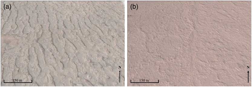
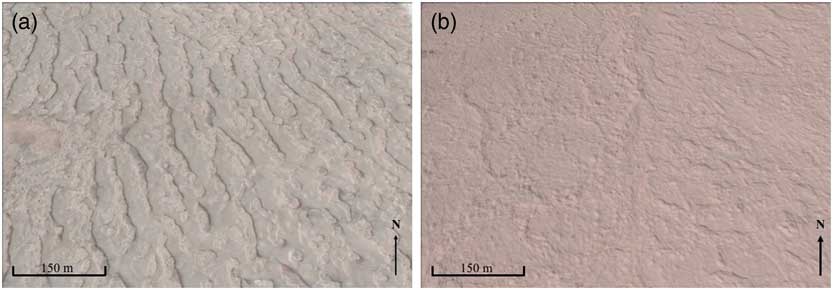
From the perspective of satellite imagery, a distinctive pattern of the sand dunes emerges (Fig. 5). On the western edge of the Soledad Formation, the deposits are well- developed transverse dunes, oriented slightly to the northwest. Further to the east, the clarity of the dune shape decreases. There, they maintain a less distinct northwest orientation, and, in many areas, the dunes more commonly mimic a star-like orientation. Transverse dunes are oriented perpendicular to the direction of wind flow, while star dunes are believed to form in variable wind trajectories (Anderson and Anderson, Reference Anderson and Anderson2010), an interpretation which is well aligned with the directions recorded by our anemometers at the west and east sites (Fig. 3).
(color online) Satellite image of sites showing the shape of the dunes. (a) On the western edge of the Soledad Formation, the deposits are well-developed transverse dunes, oriented slightly to the northwest. (b) Further to the east, the clarity of the shape of the dunes decreases and the dunes take on a more star-like form. Images were accessed from GoogleEarth in June 2016.
Dune stratigraphy
The surface of both dunes consists of a thin (cm scale) crust that is solidified by both lichens and sulfate salts. Lichen density was much more distinct in the crust at the western site (Fig. 2b and c). These biological soil crusts comprise an assortment of prokaryotic and eukaryotic organisms (Moore, Reference Moore1998).
Below the lichen crust, the next 10 to 15 cm of sediment had prominent polygonal structures up to 30 cm in width. With the overlying material removed, these structures appeared to be comprised of smaller polygons in a somewhat fractal-like pattern. Throughout the soil/sedimentary profile are irregularly spaced and somewhat horizontal accumulations of sulfate. Individual soil horizons were thus designated on the basis of changes in the sulfate concentration, color, and bulk density.
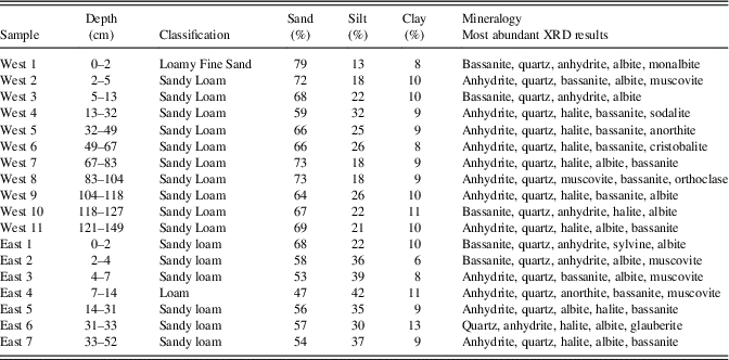
The sediment in the dunes is largely silicate in origin (quartz and feldspar) with varying concentrations of sulfate and chloride salts (bassanite, anhydrite, and halite) (Table 2). Carbonate was found only in very low concentrations. At the two sites examined in detail here, the surface layers have bassanite (a partially hydrated sulfate mineral) as the primary sulfate mineral, whereas anhydrite exceeds bassanite in most of the deeper layers. While bassanite is a somewhat uncommon mineral at the Earth’s surface, it has been found in evaporite deposits of arid regions on both Earth and Mars (Hunt et al., Reference Hunt, Robinson, Bowles and Washburn1966; Akpokodje, Reference Akpokodje1984; Gunatilaka et al., Reference Gunatilaka, Al-Temeemi, Saleh and Nassar1985; Mees and De Dapper, Reference Mees and De Dapper2005; Yen et al., Reference Yen, Ming, Vaniman, Gellert, Blake, Morris and Morrison2017). We hypothesize that frequent interactions of the surface minerals with fog favor a more hydrated sulfate species at the immediate land surface, whereas high temperatures and low water activity form and maintain anhydrite at greater soil depths.
Textural classification and most dominant minerals found in each dune layer.

Dune accretion
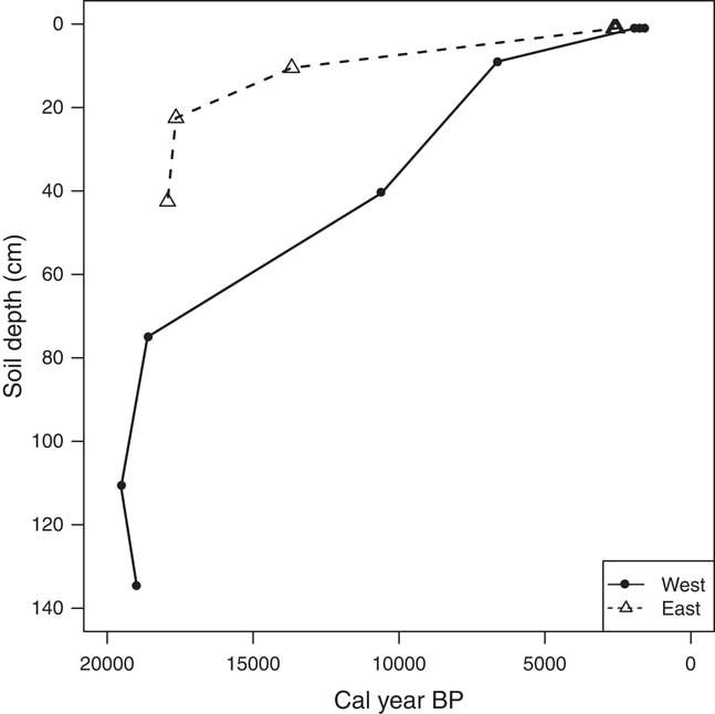
There is little evidence of pedogenesis or physical mixing beneath the surface crust. To test the notion that the dunes have accreted monotonically over time (and have not been physically or biologically mixed), we conducted radiocarbon dating at several depths in both deposits. We found that both profiles show a clear trend of increasing age with increasing depth.
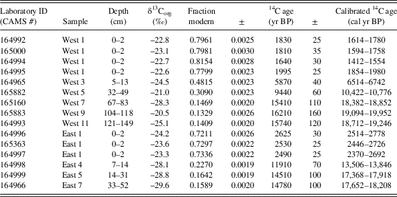
The surface crust at the west site has an average age of 1691 cal yr BP (n = 4) and the crust of the east site has an average age of 2573 cal yr BP (n = 3). Individual crust samples from the west site have ages of 1614–1780, 1594–1758, 1412–1554, and 1854–1980 cal yr BP, and individual crust samples from the east site have ages of 2514–2778, 2446–2726, and 2370–2692 cal yr BP. Both dunes have late Pleistocene maximum ages at their bases, 18,712–19,246 cal yr BP in the west deposit, and 17,652–18,208 cal yr BP in the eastern one (Table 3; Fig. 6). These dunes therefore represent the somewhat steady accumulation of captured material since the late Pleistocene. The observed increase in age monotonically with depth reflects the absence of biological and physical mixing processes. Due to the hyperarid conditions that have prevailed throughout the formation of these dunes, organic matter has been buried without significant degradation. This has left a preserved record of sedimentation and biologic material.
Radiocarbon measurements taken from strata within each dune profile. Additional data can be found in Table 3.
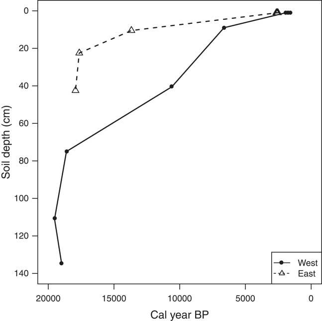
Radiocarbon ages were calibrated to calendar year BP using the CALIBomb online program (http://calib.qub.ac.uk/CALIBomb/) and using the southern hemisphere dataset SH_CAL13 (Hogg et al., Reference Hogg, Hua, Blackwell, Niu, Buck, Guilderson and Heaton2013). 2-sigma probability ranges are reported here.

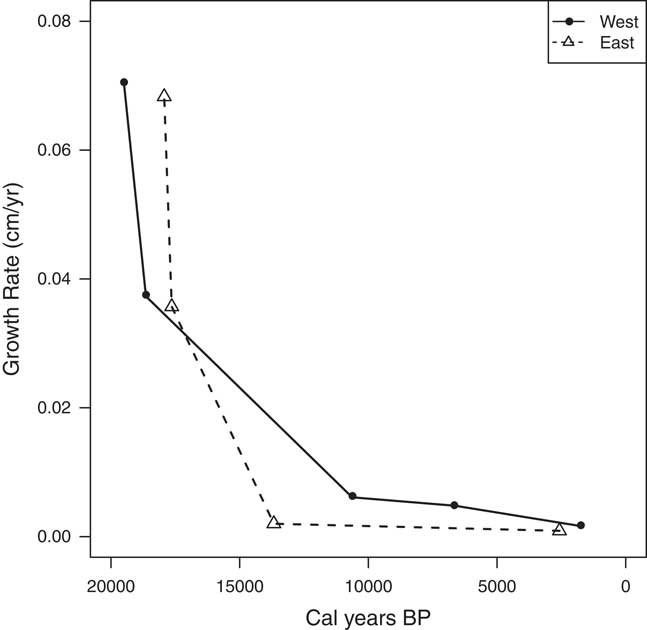
While the accumulation and growth of the dunes has been monotonic, the rate of growth has not been constant. During the early stages of accumulation, both dunes were growing at a rate of approximately 0.07 cm yr−1. This rate has decreased over time, and both sites are presently growing at rates less than 0.01 cm yr−1 (Fig. 7). Given that the magnitude and timing of growth rate changes occur simultaneously at both sites, we conclude that these dunes record a response to regional environmental change occurring during the early Holocene.
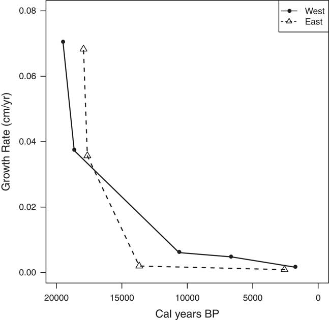
The onset of glacial melting and the subsequent rise in sea level after the last glacial maximum (LGM) began 20 to 19 ka (Yokoyama et al., Reference Yokoyama, Lambeck, De Deckker, Johnston and Fifield2000), shortly before these dunes began accreting. From 19 to 10 ka, sea level rose ~130 m, changing the elevation of our field sites from 965 and 1025 m asl to their present locations at 835 and 895 m asl (Lambeck et al., Reference Lambeck, Yokoyama and Purcell2002). This rise in sea level also moved the coastline ~7 km inland, repositioning our sites from 32 and 57 km from the coast to their present locations at 25 and 50 km from the coast. The observed rapid decline in sediment accumulation rates in the dunes examined here coincides with global sea levels approaching modern conditions at 10 ka.
Presently, fog in the Atacama Desert seldom penetrates regions above 1000 m asl (Rech et al., Reference Rech, Quade and Hart2003; Cereceda et al., Reference Cereceda, Osses, Larrain, Farías, Lagos, Pinto and Schemenauer2002; Houston, Reference Houston2006). It is therefore probable that fog intensity and frequency at our field areas were significantly lower during the LGM than they are today, given the increased elevations and distance from the coast. The lower sea level may have exposed expanses of shelf for wind deflation and the decreased fog intensity may have weakened soil surface crusts and made sulfate-rich soils on alluvial fans and uplands more susceptible to deflation. As a starting hypothesis, prior to examining the chemical and isotopic records in the sediment, we propose that the observed changes in sand deposition rates are in response to changes in sea level, corresponding to an increase in wind speeds and fog density, resulting in a decrease in the rate of sand deposition.
Paleoenvironmental records in the dunes
Textural analysis of the sediment
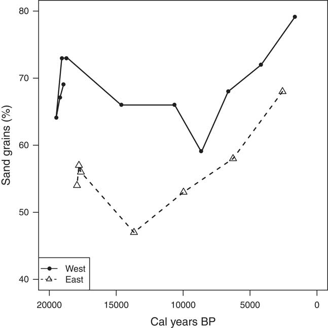
Nearly all of the sediment in the dunes has a textural classification of a sandy loam, though strata at the west site constantly have a larger grain size (more sand) relative to the east site (Table 2; Fig. 8). As previously discussed, wind speeds at the west site are ~2× higher than those at the east site. This difference in wind speed creates a spatial gradient with grain size decreasing further from the coast as the capacity for transporting larger grain sizes decreases.
Changes in sediment grain size at both sites over time. Additional data can be found in Table 2.
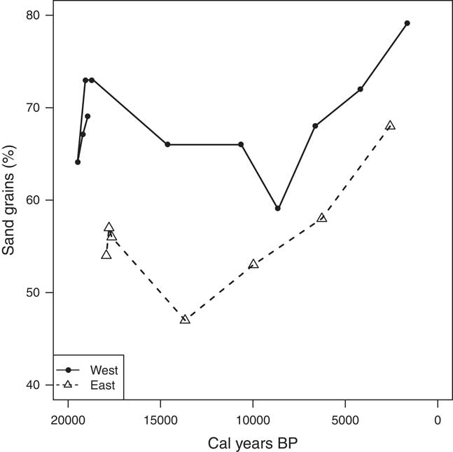
Prior to 15 ka, the grain size accumulating at each site was relatively constant (though coarser at the west site). After this time, both sites reveal a steady increase in the proportion of sand grains. We interpret this as a reflection of changes in coastal proximity and/or wind speeds linked to changes in sea level. The timing of this change coincides with the observed decrease in dune accumulation rate. Rising sea level and increasing wind speeds could both increase the size of grains transported and simultaneously increase erosion from the dunes, leading to the observed decrease in accumulation rates and increase in grain size.
Stable isotope ratios of sulfur in sulfate
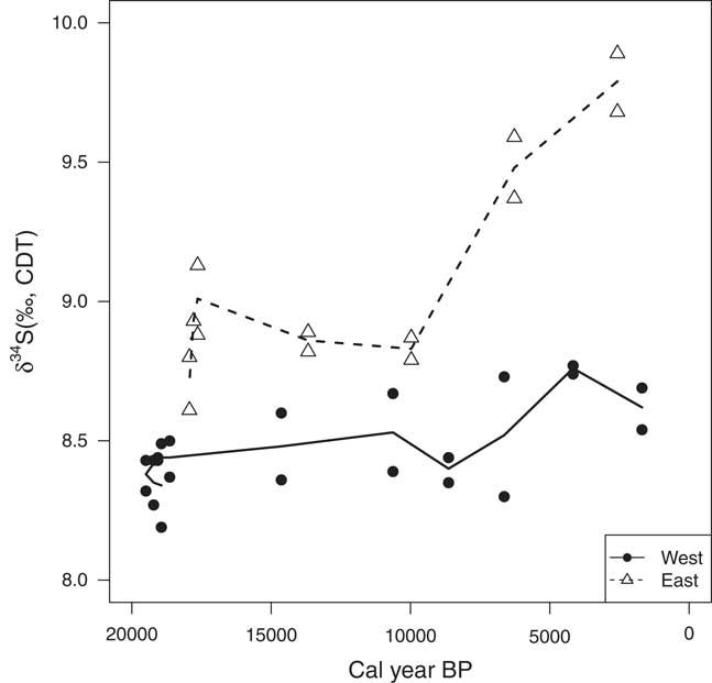
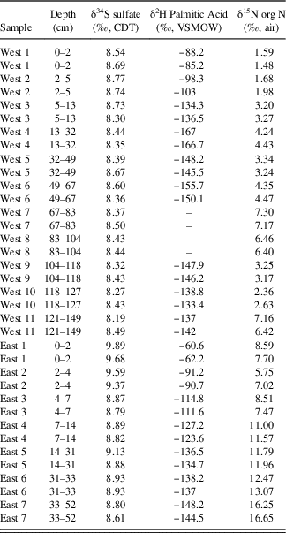
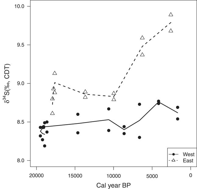
The δ34S values of the sulfate at both sites does not vary widely, averaging +8.5 ± 0.2‰ at the west site and +9.1± 0.4‰ at the east site (Table 4; Fig. 9). Possible sulfate sources to these sites include: (1) deflated sulfate rich soils from nearby alluvial fans, (2) erosion and deflation of anhydrite from the Soledad Formation, (3) deflation of evaporitic sulfate from nearby salars, and (4) various marine inputs. Rech et al. (Reference Rech, Quade and Hart2003) reported that Andean rocks have δ34S values of -5 to +5‰, and here we report values of +6‰ for the anhydrite in the Soledad Formation. Finstad et al. (Reference Finstad, Pfeiffer, McNicol, Barnes, Demergasso, Chong and Amundson2016) reported values of +5.5‰ for groundwater sulfate and +2.7 and +5.1‰ of evaporitic sulfate on the surface of nearby salars. In contrast, Bao et al. (Reference Bao, Campbell, Bockheim and Thiemens2000) has reported that biogenic marine sulfates have δ34S values ranging from +13 to +22‰, and seawater sulfate a δ34S value of about +21‰. Given these values, both sites are likely receiving the majority of their sulfate from some combination of Andean sources (ancient Soledad Formation, salars, and/or local soil sulfate) and minor marine inputs.
Measured δ34S values from extractable sulfate at both sites over time. All values are reported relative to Canyon Diablo Troilite (CDT). Additional data in Table 4.
Measured stable isotope data from each dune layer.

A shift in the isotopic composition of the sulfate, primarily at the east site, began roughly 10 ka. At this time, δ34S values begin to steadily increase, suggesting a larger input of marine sulfates (although the total amount remained small). While the change is small, it coincides to the time when other data discussed earlier suggest an increase in local wind speeds and rising sea level after the LGM. Changes in coastal proximity may have facilitated larger contributions of marine material to these deposits, leading to the observed increase in the δ34S sulfate values.
Stable isotope ratios of hydrogen in fatty acids
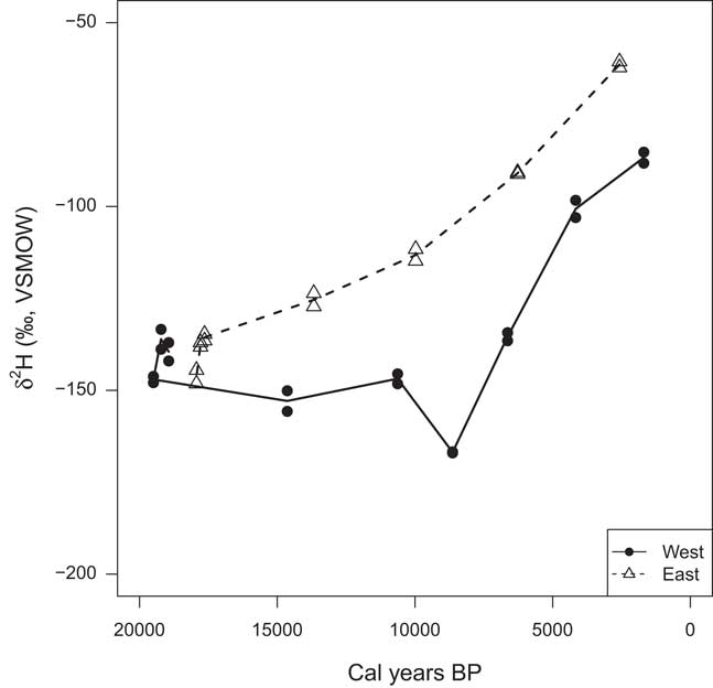
The use of δ2H values in lipid biomarkers as a paleoclimate proxy is becoming increasingly common (e.g., Andersen et al., Reference Andersen, Paul, Bernasconi, McKenzie, Behrens, Schaeffer and Albrecht2001; Sauer et al., Reference Sauer, Eglinton, Hayes, Schimmelmann and Sessions2001;Huang et al., Reference Huang, Shuman, Wang and Webb2002; Sachse et al., Reference Sachse, Radke and Gleixner2004). The basis for the approach is that photosynthetic organisms derive H from water sources, therefore the δ2H in their lipids reflects the δ2H of the source water plus a biochemically mediated isotope fractionation. Here we focus on palmitic acid, one of the most common fatty acids in microorganisms, plants, and animals. In both dunes, the δ2H value of palmitic acid at the base is close to -140‰. Values of δ2H increase with time, reaching -87‰ and -61‰ at the surface of the west and east sites, respectively (Table 4; Fig. 10). After roughly 17.5 ka, the lipids at the east site are consistently 30 to 50‰ enriched in 2H relative to the west site.
Measured δ2H values in palmitic acid at both sites over time. All values are reported relative to Vienna Standard Mean Ocean Water (VSMOW). Additional data in Table 4.

The H isotope fractionation between water and fatty acids during lipid biosynthesis is reported to range from −170 to −226‰, with a mean value of −200‰ (Sessions et al., Reference Sessions, Burgoyne, Schimmelmann and Hayes1999). Present-day coastal fog measured ~1000 km south of our field sites is reported to range from −1 to −10‰, with a mean value of −3.4‰ (Aravena et al., Reference Aravena, Suzuki and Pollastri1989). Lipids formed from this fog water experiencing a −200‰ fractionation would have a δ2H of −203.4‰. This is significantly more 2H-depleted than the lipids measured at the surface of the dunes.
Three key processes may affect the H isotopic composition of advection fog. First, as fog travels inland and begins to condense and dissipate with westerly winds, the fog vapor will become progressively 2H-depleted as the heavier isotopologue condenses out in droplets. Second, as the fog rises and warms as it crosses the continent, it will undergo preferential evaporation of 1H2O, resulting in fog with a higher δ2H relative to the starting fog. Finally, after the fog deposition, additional 2H enrichment may occur via evaporation from the land surface prior to biologic incorporation.
We suggest that the latter two processes dominate the landscape considered here and can explain the consistent difference in δ2H values between the west and east sites. The meteorological data indicate that the east site is 1.5 to 2.5 times less humid and foggy than the west (Table 1), which is further supported by visual observations of fog intensity in the field. Fog reaching the east site has likely undergone evaporative enrichment both during transport and after deposition on the landscape, resulting in consistently higher δ2H values from lipids at the east site. The δ2H in lipids at both sites increases over time, with the trend becoming most pronounced ~10 ka. We suggest that the observed pattern may be due to aridification of the region during the Holocene. Increasing temperatures and deceasing humidity would have led to a steady increase in evaporative enrichment of the fog at both sites prior to deposition.
CONCLUSION
Here, we report the discovery of small-scale late Quaternary sand dunes in a windy and fog-impacted region of the Atacama Desert. The unique accumulation of sediment has apparently occurred in response to a combination of sea level and advective fog changes that occurred from the late Pleistocene to Holocene. The dunes have accumulated in a rugged, badland-type topography that causes local variations and reductions in wind velocity, and subsequent settling of suspended particles from the surface winds. Radiocarbon ages of organic matter embedded within the deposits show that they began accumulating rapidly at the LGM, and that accumulation of sediment slowed considerably after the Pacific Ocean attained its present post-glacial level.
Due to the extreme aridity and lack of biological mixing processes, the dunes retain a detailed stratigraphic record of chemical and physical changes over the last 20 ka. Chemical and isotopic analysis of the sediment and fatty acids preserved within the dunes likely reflect elevation and coastal proximity changes following the last glacial maximum. Over this time period, grain sizes are seen to increase while accumulation rates simultaneously decrease, suggesting greater wind speeds and/or a decrease in sediment supply. Changes in δ34S values of the sediment beginning ~10 ka indicate an increase in marine influence, likely as fog, or slight changes in the source of the sulfate. Similarly, δ2H values from palmitic acid show a steady increase ~10 ka, likely resulting from increased aridity in the region during the Holocene.
This unique and continuous record of paleoenvironmental conditions provides a window into local processes that are impacted by a complex array of sea level, marine upwelling, and fog processes. The depth-increment sampling conducted here was relatively coarse in order to test whether the sediments in the dunes indeed had accumulated monotonically. It appears that much finer scale depth increments coupled with radiocarbon dating could provide a higher resolution late Quaternary record.
ACKNOWLEDGMENTS
We are grateful for the following support: funding to K.F. through the NASA Earth and Space Sciences Fellowship and NSF Doctoral Dissertation Improvement Grant (DEB-1406956); to M.P. through the CONICYT for Becas Chile Scholarship and the Fulbright Foreign Student Program Scholarship; and to R.A. through the University of California Agricultural Experiment Station and National Science Foundation grant # 0819972. Kim Lychens is thanked for her help with the fatty acid extractions. Part of this research was done at the Jet Propulsion Laboratory, California Institute of Technology, under a grant from the National Aeronautics and Space Administration. A portion of this work was performed under the auspices of the U.S. Department of Energy by Lawrence Livermore National Laboratory under Contract DE-AC52-07NA27344, LLNL-JRNL-717742.