CAMDEN
(1) St Giles Circus, Denmark Place, Denmark Street, Charing Cross Road, St Giles High Street, Andrew Borde Street, 71 Endell Street WC2 (TQ 2989 8127): excavation and watching-brief continued from 2015. A ditch of possible Roman date, aligned east–west, was recorded in the area east of 22 Denmark Place.Footnote 293
CITY OF LONDON (LONDINIUM)
(1) Bank Station Capacity Upgrade, Arthur Street Utilities Diversion Works, EC4 (TQ 32805 80776): excavation work continued from 2015.Footnote 294 Natural sand and gravels were cut by a series of pits and overlain by redeposited material, interpreted as evidence of quarrying and subsequent landscaping on the north bank of the Thames. These were cut by three substantial walls constructed from ragstone, flint and opus signinum with tile coursing, the westernmost of which stood over 2 m high. The masonry probably represents one bay or cell of a high-status domestic building set back from the Roman foreshore and port. Also associated were the remains of timber steps, multiple floor surfaces and deposits of painted wall-plaster. At least two kiln or oven structures were present at the west of the building footprint, in either an additional bay or a separate structure. The large western wall exhibited clear signs of rebuilding and alteration, suggesting that the building was in use for a long period and may have had different functions during that time. Several Roman coins, dress pins and glass objects (including a rare glass bead necklace) were recovered. A dumped deposit close to the top of the Roman sequence contained a group of 23 coins of mid-fourth-century date (to be reported upon later).Footnote 295
(2) St Bartholomew's Hospital, Maggie's Centre (north wing), West Smithfield EC1A (TQ 31913 81597): work continued from 2015.Footnote 296 In the southern part of the trench a Roman ditch measuring c. 14 m long, 1.5 m deep and 3.3 m wide was recorded curving from west to north-east, with an ‘ankle-breaker’ slot in its base (fig. 33). The site lies within the western cemetery of Roman London and six inhumations were recorded accompanied by hobnails, a coin and iron objects. A seventh grave was found to contain no skeletal remains although hobnails, a jet bracelet (or anklet) and a complete pot were present. There was no dominant orientation of the graves.Footnote 297
St Bartholomew's Hospital, Maggie's Centre (north wing): a 14 m-long curving ditch which pre-dated the western cemetery, looking north-west. (© MOLA)

(3) St Bartholomew's Hospital (Pathology Centre), West Smithfield EC1A (TQ 31856 81562): a watching-brief found that although the site lies within the western cemetery of Roman London, no burials were present due to modern truncation.Footnote 298
(4) 2–6 Cannon Street, EC4 (TQ 32155 81005): no evidence was found for the continuation of a Roman wall recorded in the southern part of the site during excavations in 1955 under the site code GM168.Footnote 299
(5) 40, 48, 49 Leadenhall Street, 19–22 Billiter Street, 108–114 Fenchurch Street, 6–13 Fenchurch Buildings, EC3 (TQ 33335 81070): two evaluation trenches on the eastern side of the site each revealed a gully. The first, oriented approximately east–west, contained pottery of a.d. 50–300, while the second, aligned roughly north-west–south-east, contained sherds dated a.d. 50–160. The east–west gully fill was cut by a pit containing material with a terminus post quem of a.d. 120. The other gully was sealed by redeposited brickearth which was cut by pits with late first-/early second-century pottery and by a collection of stake-holes which may represent the corner of a building. Three headless pig carcases found buried in a shallow pit may possibly be a foundation sacrifice relating to the building represented by the stake-holes. A third trench located to the north of those containing the gullies exposed possible quarry pits of Roman date.Footnote 300
(6) Queensbridge House, Upper Thames Street, EC4 (TQ 32282 80841): watching-brief and targeted mitigation excavation continued from 2011.Footnote 301 The site contains or is adjacent to four Scheduled Ancient Monuments including the Huggin Hill Roman bath-house. Investigations in the northern part of the site located well-preserved walls and features relating to the bath-house and confirmed that localised areas of the structure had survived outside the basemented area and along the Huggin Hill street frontage. The remains included the previously recorded walls of a heated chamber (originally identified as Room 32 from the 1960s excavations) associated with the caldarium and the western wall of Room 28, which in the original excavation was described as an unheated chamber. Layers and surfaces associated with the lower levels of the bath-house construction were also recorded. Further archaeological mitigation works will be carried out as the redevelopment progresses.Footnote 302
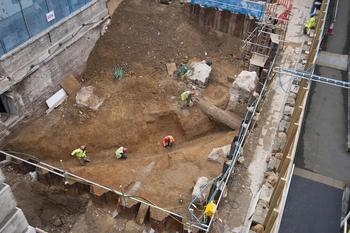
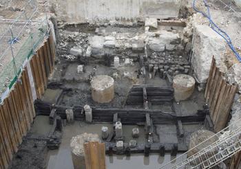
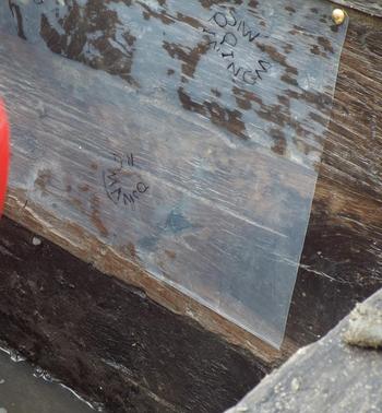
(7) Sugar Quay, Lower Thames Street, EC3 (TQ 33290 80573): excavation and watching-brief work continued from 2015.Footnote 303 The natural foreshore was recorded as well as geoarchaeological evidence for watercourses running south to the Thames through the site, representing the many small streams which drained the eastern hill of Londinium. The earliest Roman structure was an unusual front-braced timber revetment which sat directly on natural clay and is presumably first century in date. More substantial late first-century river walls were recorded running along the foreshore for c. 20 m east–west; these consisted of base-plates, upright piles and planks. The linear plank revetments were replaced in the third quarter of the second century by a major structure, known as the box quay, constructed in the caisson style with oak timbers laid in regular courses to create a series of boxes (fig. 34). Significantly, along the oak timbers used within the box quay a multitude of stamps were present (fig. 35). These were not on a single edge or along a single plane, suggesting that the timbers had been stamped prior to their use in the structure and therefore relate to timber supply and management rather than carpentry. The box quay was replaced by the defensive river wall in the mid- to late third century. A significant extent of the wall was exposed and will be preserved in situ beneath the new building. On this site its form was monumental, consisting of large blocks of Hassock and ragstone as well as degraded limestone blocks and elements of monumental architecture, possibly reused elements from a large Antonine public building on the hill behind the site. Analysis work continues.Footnote 304
Sugar Quay, Lower Thames Street: the mid-second-century timber box quay under excavation, with the masonry third-century river wall in the background. (Photograph: A. Chopping, MOLA)

Detail to show the circular stamped motifs seen throughout the timbers used within the box quay. (Photograph: M. Cox, MOLA)

ENFIELD
(1) 53 Leighton Road, Bush Hill Park, Enfield (TQ 3405 9551): work identified the likely mid- or mid-/late second-century western boundary ditch of the Romano-British settlement along Ermine Street. The northern end of the known flanking path overlay a ‘ground armouring’ deposit at the edge of the ditch. The area had subsequently been used for the dumping of rubbish including iron-working residues up to its abandonment in the late second/early third century. Further north a possible cultivation subsoil had developed over denuded natural, probably mainly in the second century. Later/post-Roman deposits comprised phases of hillwash deposition with little or no human activity. A notable find included sherds of a late second-century polychrome glass cup.Footnote 305
HACKNEY
(1) Principal Place, Worship Street, EC2 (TQ 33350 82090): excavation work continued from 2015.Footnote 306 A final phase in the area between Plough Yard and Shoreditch High Street exposed a further seven inhumations and at least one cremation from the northern cemetery of Roman London. A total of 13 burials has been found in this area with another 32 previously found in the area north of Worship Street. A small number of quarry pits and several ditches were also located as well as further evidence for a north–south-oriented Walbrook channel. The majority of the Roman evidence was dated to the late third/fourth century, although some residual earlier pottery was also recorded.Footnote 307
HOUNSLOW
(1) Sky Broadcast Storage Centre, BSKYB Building, 1 Harlequin Avenue, Hounslow, TW7 (TQ 16440 77900): evaluation continued from 2015. A small pit containing iron hobnails and sherds of sand-tempered ware dated a.d. 50–400 was recorded in the southern part of the site.Footnote 308
LAMBETH
(1) Lambeth Palace Library, Lambeth Palace Road, SE1 (TQ 30795 79241): five trenches were excavated revealing a well-dated sequence of intercutting ditches dating from the early first to the late fourth century. The earliest ditches were contemporary with a nearby pit and represent conclusive evidence for the late Iron Age/early Roman transition. The majority of the ditches appeared to be associated with water management although the latest (a.d. 250–400) had a distinctive V-shaped profile suggesting that it may have been a boundary or enclosure ditch.Footnote 309
SOUTHWARK
(1) 133–135 Great Suffolk Street, SE1 1PP (TQ 3222 7965): evaluation of three trenches recorded the remains of a possible quarry pit/ditch dating to between the first and fifth centuries.Footnote 310
(2) King's Place, north-east of junction of Newington Causeway and Harper Road, SE1 (TQ 32250 79506): an evaluation found a silty sand layer containing occasional sherds of late Roman pottery, which was interpreted as an agricultural soil.Footnote 311
(3) The Science Gallery London and Guy's Bar (The Spit), Boland House, St Thomas Street, SE1 9RY (TQ 3284 7923): an evaluation identified two broad phases of Roman activity along the western side of the site, corresponding with known high ground associated with the northern or Bridgehead Island. The earlier phase dated from the late second century and comprised two episodes of water management or the defining of property boundaries, represented by parallel ditches. Finds recovered from the fills of both ditches and dump layers included fragments of opus caementicium and Radlett and Eccles bricks, a small lathe-turned bone counter and charred pulses and grains. Several episodes of refuse disposal or levelling followed the abandonment of these features in the later third century. It is likely that the ditches ran roughly perpendicular to Road 1, precursor of Borough High Street, and represent land-use just beyond the ribbon development east of the road, while the lack of human activity in the eastern portion of the site might imply the presence of an active channel.Footnote 312
TOWER HAMLETS
(1) London Fruit and Wool Exchange, Brushfield Street, E1 (TQ 3362 8173): watching-brief work continued from 2015.Footnote 313 Two further Roman inhumations were recorded, bringing the total to 21, 10 of which had pots dated c. a.d. 120–250 deposited within the graves.Footnote 314