Introduction
After a failed polar attempt in 1894 from Spitsbergen, nowadays Svalbard, Walter Wellman (1858–1934) in the spring of 1898 was again ‘determined to have a real try at the [North] Pole’ (Wellman Reference Wellman1911: 40). Wellman had paid close attention to the triumphal return from the Arctic of Fridtjof Nansen, most especially to the money and fame Nansen acquired through his ‘dash’ for the North Pole from Fram. Nansen had returned through the islands of Zemlya Frantsa-Iosifa, and Wellman conceived of a similar ‘polar dash’ using these same islands as his base.
Details of Wellman's renewed attack on the North Pole emerged as early as the summer of 1897 in the Norwegian press, immediately after Wellman had arranged to take advantage of Nansen's new status as the arbiter of all things polar and meet with him in Norway. Wellman planned to hire a Norwegian Arctic sealing vessel and, along with eleven other participants, used Frederick Jackson's recently abandoned camp at Cape Flora [Mys Flora] on Northbrook Island [Ostrov Nortbruka] as a base to try and reach the pole from Cape Fligely [Mys Fligely] on Crown Prince Rudolf Island [Ostrov Rudolfa Line] the following spring (Aftenposten (Kristiana) 25 August1897). The American press reported on the expedition just after New Year, 1898, relaying that Wellman had ‘just returned from Europe, and held a long conference with Nansen concerning his plan, which Nansen approved with warm terms’ (Broad Ax (Salt Lake City) 1 January 1898: 2).
The National Geographic Society formed a committee ‘to advise Mr. Wellman concerning the scientific work to be undertaken.’ The committee ‘drafted a statement indorsing the aims and purposes of the expedition, and suggested the addition to the exploring party of three scientific observers’ (National Geographic Magazine 1898: 373). The group consisted of society president Alexander Graham Bell, General A. W. Greely, U.S.A., Professor Simon Newcomb, Professor G. K. Gilbert, Dr. C. Hart Merriam, and Commodore George W. Melville, U.S.N. The Society added financial support to the expedition of US $1000, and encouraged its members to provide additional support.
The remainder of the expedition budget Wellman gathered from donations and loans from several prominent Americans, a sum that added to a modest $12,865. With this, Wellman chartered the Norwegian ice-steamer Frithjof, under command by the legendary Norwegian ice-master captain Johan Kjeldsen (1844–1909) (Kjær Reference Kjær2006). The ship sailed from northern Norway to Zemlya Frantsa-Iosifa with three other Americans: Evelyn Briggs Baldwin (1862–1933) of the United States Weather Bureau, Washington D.C, Quirof Harlan (1873–1926) of the United States Coast and Geodetic Survey, Washington, D.C., and a doctor from Grand Haven, Michigan, Edward Hofma (1859–1936). Also on board, and part of the expedition team, were five Norwegians: Paul Bjørvig (1857–1935), Bernt Bentsen (1860–1899) and Daniel Johansen (c. 1870–1907), all from Tromsø, and two brothers from Hammerfest: Emil (1872–1942) and Olaf Ellefsen (1874–1972) (Evind Klykken, personal communication, 11 August 2013). Bjørvig was a veteran Arctic hunter, sailor and navigator. Both Bjørvig and Emil Ellefsen had been with the Wellman's Svalbard expedition in 1894. Bentsen also had major Arctic experience and had been on board Fram during the polar sea drift 1893–1896. E. B. Baldwin had spent a year with Peary in 1893–1894 in northwestern Greenland and had briefly visited Svalbard in the sumer of 1897 (Capelotti forthcoming). All together the expedition team had plenty of high Arctic experience.
Frithjof dropped anchor off Hall Island [Ostrov Gallya] on 30 July and there, at Cape Tegetthoff [Mys Tegetkhof], Wellman's crew used a hut salvaged from Frederick Jackson's camp at Mys Flora and built Harmsworth House, the expedition's headquarters. Wellman appointed Evelyn Briggs Baldwin as the expedition's second-in-command and sent him, together with the Norwegians, north to build an advance hut for Wellman's planned polar sledge journey the following February. ‘To our imaginations,’ Wellman wrote, ‘Franz Josef Land presented itself as a paradise of opportunity’ (Wellman Reference Wellman1911: 42).
The sledge journey for the Pole in 1899, failed off the east coast of Ostrov Rudolfa Line when Wellman slipped and fractured his leg and later an ice-quake took most of their provisions. Realizing that the North Pole was beyond his reach, Wellman now tried to salvage both his expedition and his reputation by finding new geographical features he could name after his benefactors. He had done something similar during his 1894 expedition but none of those place names survived. In Zemlya Frantsa-Iosifa, however, several did.
In April, 1899, crippled and in bed at Harmsworth House, Wellman sent Baldwin and the four Norwegians, on a geographic reconnaissance to the north and east. Baldwin's sledging trip to the eastern shore of Wilczek Land [Ostrov Zemlya Vil’cheka] and then north, led to the major geographic discovery of the expedition. This was Graham Bell Land [Ostrov Greem-Bell], named for the president of the National Geographic Society, the scientist and inventor Alexander Graham Bell (1847–1922) (see Capelotti Reference Capelotti2006).
With Wellman's ‘Pole dash’ and these two journeys with Baldwin as commander, establishing the advanced hut in 1898 at Cape Heller [Mys Gellera] and the Wilczek Land [Ostrov Zemlya Vil’cheka] reconnaissance of 1899, along with a cruise around Markham Sound [Proliv Markema] at the end of the expedition on board the relief steamer Capella, added 22 new islands to the charts of Zemlya Frantsa-Iosifa. Three of these were previously-discovered by Payer 1874, one as a peninsula and two recognized as capes although Baldwin discovered that Payer's Cape Berghause and La-Ronciera Peninsula, were islands, today Ostrov Bergkhauza and Ostrov La-Rons’yera. Cape Littrow, which Wellman thought an island, is still a peninsula today called Poluostrov Littrova. The four islands Wellman thought he spied during his ‘Pole dash’ were found to be illusions by the expedition 1899–1900 of the Duke of the Abruzzi that arrived in the archipelago just as Wellman was departing in July, 1899 (Wellman Reference Wellman1911: 117). (For general discussions on who receives the honour of a place-name and the interplay of territorial disputes and toponymics see, for example, Dodds Reference Dodds2000: 176–210; Wråkberg Reference Wråkberg, Bravo and Sörlin2002: 155–197, Reference Wråkberg, Elzinga, Nordin, Turner and Wråkberg2004: 123–143).
Upon his return to the U.S., Wellman told the press that he was ‘giving the islands, straits, and points good American names’ (Boston Globe 9 October 1899). In an article published soon after in National Geographic, Wellman wrote that: ‘Upon these new lands, their capes and straits, we had the pleasure of placing the names of well-known American scientific and public men who had befriended the expedition’ (Wellman 1899: 503; Fig. 1).
Wellman's chart of Zemlya Frantsa-Iosifa following his 1898–1899 expedition (Wellman 1899).

Yet, although he told a reporter that ‘I don't favor the cooperation of nations in Arctic exploration’ (Boston Globe 9 October 1899), Wellman's list of place names included tributes to previous (non-American) explorers of the islands. These included the Austro-Hungarian discoverer of new land they named ‘Kaiser Franz Josef Land,’ Julius von Payer (1842–1915), as well as Frederick Jackson (1860–1938), whose British expedition supplied Wellman with the hut that became both Wellman's base camp and its British name, Harmsworth House, after the pioneer of the English tabloid journalism, Alfred C.W. Harmsworth (1865–1922), the financier of the 1894–1897 Jackson-Harmsworth expedition to the area.
Just south of McClintock Island [Ostrov Mak-Klintoka], Baldwin describes in his diary how they sighted an island from Frithjof in 1898: ‘Friday July 29. The island south of McClintock Island does not appear upon any of the charts’ (Baldwin Reference Baldwin and Capelotti2004: 36). This is most likely the island Wellman named Aagaard after his Norwegian agent in Tromsø, Consul Andreas Zacharias Aagaard (1847–1925). Aagard functioned as Wellman's Norwegian agent from his first Arctic expedition in 1894 on board Ragnvald Jarl until his last attempt to fly to the Pole, with a dirigible from Danskøya, at north-west Spitsbergen, in 1909.
The majority of names, however, do in fact derive from ‘well-known American scientific and public men who had befriended the expedition’ (Wellman 1899a: 503). Wellman wrote that many of the names honoured ‘friends who had helped me finance the expedition’ (Wellman Reference Wellman1911: 116–117). He included in this list ‘President McKinley, Vice-President Hobart, J. Pierpont Morgan, William C. Whitney, Cornelius Bliss, Judge Lambert Tree, Levi Z. Leiter, Helen Gould, William K. Vanderbilt [and his] brother Arthur Wellman’ (Wellman Reference Wellman1911: 40). With the exception of U.S. Vice President Garret A. Hobert (1844–1899), all the mentioned people received place names in Zemlya Frantsa-Iosifa from Wellman's 1898–99 campaign.
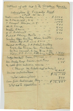
This published list, however, leaves out more than 30 other names Wellman used in Zemlya Frantsa-Iosifa. Fortunately, two other sources provide some insight into these names. The first is Wellman's 1899 account of the expedition in National Geographic. The other is a list of friends of the expedition, published here for the first time, and recently found in the papers of Arthur Wellman, which were deposited in the archives of the National Air and Space Museum in Chantilly, Virginia, in 2004 (Fig. 2).
Statement of all aid to the Wellman expedition (Wellman Reference Wellman1898). In this document, Wellman lists his benefactors, including William K. Vanderbilt, heir to the Vanderbilt fortune, and J. Pierpont Morgan, the American financier. Both contributed $1,000. Amongst those who donated $200 are the president and vice-president of the United States, William McKinley and Garret Hobart, as well as cabinet secretaries and current and former U.S. senators.

The ‘statement of all aid to the Wellman Expedition’ allows us, in many cases for the first time, to match many of the names on Wellman's published lists (Wellman Reference Wellman1899a) and descriptions (Wellman Reference Wellman1911: 40, 116–117, 134–135) with full names, along with the actual monetary contribution of the individual to the expedition. This single document verifies the origin of 23 place names Wellman attempted to leave behind in Franz Josef Land [Zemlya Frantsa-Iosifa]. This in turn allows us to eliminate much later confusion over the origin of several dozen place names to the archipelago.
Fort McKinley and the mirage islands
The Wellman expedition journeys to establish the advance hut in autumn, 1898, and to attempt to reach the Pole in the February, 1899 ‘pole dash,’ left behind a series of names, few of which survive. In some cases these were islands that had already been reported, or they were capes or peninsulas misidentified by Wellman as islands, or they were Arctic mirages altogether. These included two ‘islands’ along the south-eastern coastline of Hall Island [Ostrov Gallya], McGee Island, that was in fact Cape Littrow [Poluostrov Littrova,] and Payer Island, which was previously named as ‘Cape Berghaus’ by Payer (Reference Payer1876), although Baldwin in 1898 was able to show that ‘Cape Berghaus’ was actually an island and is today named Berghause Island [Ostrov Bergkhauza] (Fleming Reference Fleming1907).
The four non-existent islands Wellman named Ben Cable, Tom Johnson, Jesup, and John Hay. These were mirages Wellman thought he saw to the northeast of the spot of his furthest advance north, a point on the east coast of ‘Crown Prince Rudolf Land’ [Ostrov Ruddol’fa] he named Cape Arthur Wellman (1856–1933) after his brother/business manager/major domo.
The source of McGee Island is William John McGee (1853–1912), who at the time of Wellman's expedition was the chief ethnologist of the Bureau of American Ethnology and who would later become the president of the National Geographic Society. As McGee does not appear in Wellman's list of financial supporters, as a scientist he would have lent the expedition both scientific credibility and support within the National Geographic Society, whose imprimatur was becoming an essential component to the expeditions of American explorers. At the time for Wellman's expedition, McGee was acting president of the American Association for the Advancement of Science (1897–1898) and later president of the American Anthropological Association 1902–1912. He was on the board and, from 1898, was vice president for the National Geographic Society and part of the ‘Wellman scientific committee’ and later appointed president (1904–1905) of the National Geographic Society.
Wellman's ‘McGee Island’ did not survive on the map, although it can still be found in the archipelago at a different location. Here the name was set during Ziegler Polar Expedition of 1903–1905 to a tiny island, located between, nowadays, [Frederick] Jackson [Ostrov Dzheksona] and Payer Islands [Ostrov Payera] in the Italian Strait [Proliv Ital’yanski] (Fleming Reference Fleming1907).
Wellman later described two of the mirage islands, writing that he had ‘named them after two most valued friends, Ben T. Cable and Tom Johnson’ (Wellman Reference Wellman1911: 117). Ben T. Cable is most likely Benjamin Taylor Cable (1853–1923) who was a successful entrepreneur and U.S. Representative from Illinois. Tom Johnson is most likely Thomas Loftin Johnson (1854–1911), a U.S. Representative from 1891–1895 and the 35th mayor of Cleveland, Ohio, between 1901 and 1909, in Wellman's former home state. Today, Johnson is considered a great influence in the progressive movement in the United States that took place in the early 20th century.
A third mirage island, Hay Island, derives from the hand-written list of Wellman's expedition supporters, which twice mentions the name of ‘Ambassador Hay,’ who provided both a grant of $1,000 and a further loan of $740. This was John Milton Hay (1838–1905), the U.S. ambassador in London who was appointed Secretary of State by President McKinley in August of 1898 just as Wellman's expedition was arriving to Mys Tegetkhof.
The fourth mirage, Jesup Island, can also be found on the list, and refers to Morris Ketchum Jesup (1830–1908), a banker, philanthropist, president of the American Museum of Natural History, and major contributor to the expeditions of Robert E. Peary. Jesup's name does not survive in Zemlya Frantsa-Iosifa but Peary immortalised it as Cape Morris Jesup, the northernmost point of mainland Greenland. Jesup donated $500 to Wellman's expedition.
The advance base created by the five Norwegians working under Baldwin was named Fort McKinley, after the then-current President of the United States, William McKinley (1843–1901). Like Wellman, McKinley was a native of Ohio. Fort McKinley was located on the northwestern coast of Wilczek Land [Ostrov Zemlya Vil’cheka], on the slope of a small hook of land called Cape Heller [Mys Gellera] that projects westward into Austria Sound [Proliv Avstriyskiy]. It was at Fort McKinley that Bentsen died on 2 January 1899, forcing Bjørvig to sleep beside his dead companion for nearly two months until Wellman arrived for his ‘polar dash.’ Bentsen's grave can still be found at Fort McKinley.
North of Fort McKinley, Wellman thought he had identified two other previously unknown islands. The first he named for Lyman Gage (1836–1927), the then-serving Secretary of the Treasury who, according to Wellman ‘statement of aid,’ had donated $200 to the expedition. The second he named Whitney Island, almost certainly from the American financier William C. Whitney (1841–1904), a political reformer who had served as Secretary of the Navy from 1885–1889. The name Whitney Island was eventually discounted when it was seen to be Payer's ‘La Ronciere Peninsula,’ which itself turned out to be an island (Peters and Porter 1907). Wellman had tried fixing this name in the Arctic before, when in 1894 he named a cape near Kapp Platen, Nordaustlandet, as ‘Cape Whitney,’ as well as a ‘Walsh Island’ (New York Times 1894). Neither survived into the place names of Svalbard.
Wellman named two capes on ‘Whitney Island’ (now La Ronciere Island [Ostrov La-Rons’yera]). These are Cape Robert Hitt on the northern edge of the island and Cape Frick on the southeastern corner of the island. These names derive from Henry Clay Frick (1849–1919), an industrialist, financier, and chairman of Carnegie Steel Company who donated $200 to the expedition, and Robert Roberts Hitt (1834–1906), a close associate of Abraham Lincoln, long-time government servant and member of the U.S. House of Representatives, who gave Wellman $250 for the expedition. Payer (Reference Payer1876) named this cape ‘Kap Bates’ after Henry Walter Bates (1825 –1892). Bates was Assistant Secretary at the Royal Geographical Society (RGS) and edited the English translation of Koldeway's book, The German Arctic Expedition 1869–70, in which Payer participated (Koldeway Reference Koldeway1874). Here the name did not survive but Bates still has his name immortalised at Franz Josef Land, as Leigh Smith named a sound ‘Bates Channel’ [Proliv Beytsa] (80o 04’N, 49o 45’E) (Markham Reference Markham1881; Capelotti and Forsberg Reference Capelotti and Forsberg2013).
Of the eight islands named by Wellman on the direct route from the Harmsworth House base camp on Hall Island to the place where the polar attempt turned back off the east coast of Ostrov Ruddol’fa, only one place name survives: Gage Island. The names of the two capes Wellman placed on ‘Whitney Island’ also survive on modern charts.
The capes and straits of Wilczek Island [Ostrov Zemlya Vil’cheka]
North of Fort McKinley, the archaeological remains of which still survive, is the northern coast of Wilczek Land [Ostrov Zemlya Vil’cheka]. Along this coast Wellman's expedition, during Baldwin's 1899 sledge journey, located six capes. From west to east, these are capes Gorman, Fairbanks, Foraker, Hanna, Vilas, and Elkins. The ‘statement of aid’ demonstrates that each of these six capes along the northern shore of Wilczek Land [Ostrov Zemlya Vil’cheka] was named for a serving or former U.S. senator. For Wellman, a Washington, D.C. correspondent, this is a reflection of the close relationship he had to the politicians on whom he reported.
Cape Gorman derives from Arthur P. Gorman (1839–1906), who served as Senator from Maryland from 1881–1899 and again from 1903–1906. Gorman donated $200 to the expedition but his name did not survive in the archipelago.
Cape Fairbanks derives from Charles W. Fairbanks (1852–1918), who served in the Senate from Indiana 1897–1905 and as Vice President of the United States from 1905–1909. Fairbanks, Alaska, was named in his honour. Fairbanks contributed $200 to Wellman's expedition. ‘Fairbanks’ name today survive only as Skala Ferbanksa, a peak a few miles inland.
Cape Foraker derives from Joseph B. Foraker (1846–1917), a former governor of Wellman's home state of Ohio and later a Senator from that state from 1897–1909. Foraker donated $100 to Wellman's expedition. The name ‘Foraker’ does today occur both as a cape and peak [Skala Foraker].
Cape Hanna derives from Marcus A. ‘Mark’ Hanna (1837–1904), a wealthy businessman and Senator from Ohio from 1897–1904 who managed the presidential campaigns of fellow Ohioan, William McKinley. Hanna had donated $500 to the expedition.
Cape Vilas derives from William F. Vilas (1840–1908). As noted in the ‘statement of aid,’ Vilas was an ex-Senator at the time of Wellman's expedition 1898–1899, having served as Senator from Wisconsin from 1891–1897. Vilas donated $200 to the expedition.
Cape Elkins derives from Stephen B. Elkins (1841–1911), an industrialist who served as Secretary of War from 1891–1893 and as a Senator from West Virginia from 1895–1911. Elkins controlled large coal interests in West Virginia and donated $250 to the expedition. The place name never survived and as Wellman's published map was in very poor scale, the exact location of this cape has been impossible to trace on the eastern side of Ostrov Zemlya Vil’cheka.
The affiliations with the U.S Senate ended on the east coast of Ostrov Zemlya Vil’cheka, where a seventh cape, Cape Lamont, derives from Daniel S. Lamont (1851–1905), the individual who succeeded Stephen Elkins as Secretary of War. Lamont, who had worked his way up from Democratic Party functionary in New York State to become Secretary of War, served in that capacity from 1893–1897. He donated $200 to the expedition.
The waterway that separates Ostrov Zemlya Vil’cheka from ‘Whitney Island’ (La Ronciere Island), Wellman named after William K. Vanderbilt (1849–1920), heir to the Vanderbilt fortune, who donated $1,000 to the expedition. The waterway that joins to Vanderbilt Sound and separates Ostrov Zemlya Vil’cheka from Graham Bell Land, Wellman named for J. Pierpont Morgan (1837–1913), the great American financier, who matched Vanderbilt's donation of $1,000 to the expedition. Vanderbilt Sound was most likely seen and named already by Payer (Reference Payer1876), as Lindeman Bay, after the Bremen based Moritz Lindeman (1823–1908) much involved in the German North Pole expeditions 1868–1870 (Koldeway Reference Koldeway1874) and also later in the Tegetthoff expedition.
Such donations do not nowseem like a high cost to pay to have one's name attached to an island. And while there are many ways to configure current value, $150 spent on a project in 1898 would require the equivalent of $138,000 in 2013 dollars.
The discovery of Graham Bell Land
On Wednesday, 26 April 1899, Baldwin and a party of four Norwegians including Daniel Johansen, Emil Ellefsen, Olaf Ellefsen, and Paul Bjørvig left Harmsworth House and by Saturday, 29 April, they had reached Cape Frankfurt [Mys Frankfurt] and crossed ice-filled Austria Sound [Proliv Avstriyskiy] to Cape Hansa [Mys Gansa] on the southwest corner of Wilczek Land [Ostrov Zemlya Vil’cheka]. They camped north of a group of islets Payer had named the Klagenfurt Islands [Ostrov Klagenfurt] (Payer Reference Payer1876, II: xvi–xvii), and beyond which no one had yet ventured. Baldwin carried with him explicit instructions from Wellman that he was to list his findings after the following mode: islands A, B, C, capes a, b, c, and so forth, and leave any actual naming to Wellman himself (Baldwin Reference Baldwin and Capelotti2004: 156).
On Sunday, 30 April, as they continued along the southern coast of Ostrov Zemlya Vil’cheka, past two basaltic cliffs and interior mountains separated by glaciers, until the team reached Cape Höfer [Mys Khofer] on the south-east corner of Ostrov Zemlya Vil’cheka. There, Baldwin spotted three islands to the southeast. Wellman later named these islands McNulta, Dawes, and Tree.
Tree Island derives from Judge Lambert Tree (1832–1910), a former ambassador to Belgium and Russia and an arts patron who had presided over corruption trials of city officials in Chicago. According to Wellman's ‘statement of aid,’ Judge Tree donated $150 to the expedition. Today this island is named Ostrovok Derevyanny and most likely the translator of Wellman's place name into Russian, thought it was named after ‘trees,’ maybe driftwood which can be found along the beaches in the archipelago, arriving from Siberia. Also listed on the statement is ‘Comp. Dawes,’ a reference to the then-Comptroller of the Currency Charles G. Dawes (1865–1951), who donated $100 to the expedition. Dawes, who like Wellman was born in Ohio and lived part of his early life in Nebraska, later became famous as chair of the committee that authored the Dawes Plan for reparations following World War I. Dawes received the Nobel Peace Prize in 1925 for this work, and served as the 30th Vice President of the U.S. under Calvin Coolidge. The likeliest source for ‘McNulta’ is John McNulta (1837–1900), a former congressman from Illinois who lived in Washington, D.C.
Baldwin's party continued on for several miles until they came across ‘a large bay never before seen by man’ (Baldwin Reference Baldwin1901: 354–356). Following his instructions from Wellman, Baldwin named this ‘Bay A’. This became Helen Gould Bay, after the multimillionaire heiress daughter (1868–1938) of the notorious robber baron Jay Gould. On 2 May, the team crossed 5.3 miles of twisted ice in Helen Gould Bay toward a basalt cliff Baldwin temporarily named cape ‘C,’ that Wellman named Cape Lamont. North of Cape Lamont, at Cape Elkins, Baldwin noted a glacial slope on the eastern side of the fjord and realised that what he was now crossing was not a fjord but a strait. This proved to be the waterway that separated Ostrov Zemlya Vil’cheka from what Baldwin now realized was a new and large island. The waterway, which became Pierpont Morgan Strait, separated Ostrov Zemlya Vil’cheka from Graham Bell Land [Ostrov Greem-Bell].
Baldwin and the Norwegians reached the cape on the southern shore of Ostrov Greem-Bell on the evening of 4 May. The cape was named Cape Leiter. In Wellman's 1911 account of the expedition, he mentions raising funds from Levi Z. Leiter (1834–1904) (Wellman Reference Wellman1911: 40; New York Times 10 June 1904), a pioneer in dry goods stores who became a major philanthropist in Chicago later in life. Leiter's name does not occur on the ‘statement of aid’ but there is a category of ‘various contributions’ totaling $4,000 so it is possible he fell into this category.
With their way up the eastern coast of Ostrov Greem-Bell blocked by ice, Baldwin and his party headed northeast, toward a low point on the western side of the island. Wellman later named this cape for John R. Walsh (1837–1911), who at the time was head of three major banks in Chicago, including Chicago National Bank. Walsh was later convicted of misappropriation of funds and sentenced to five years imprisonment in the Federal Penitentiary in Leavenworth, Kansas, and died a few days after his early release on medical grounds in 1910 (Tarr Reference Tarr1966; New York Times 24 October 1911). As with ‘Cape Whitney’ at Nordaustlandet, in 1894, ‘Walsh Island’ did not survive in the place names of Svalbard but Cape Walsh [Mys Uolsha] still survives in Zemlya Frantsa-Iosifa.
Baldwin's team cut back across Graham Bell Land to an easternmost point Wellman named Cape Olney. Like the cape soon discovered further north, Cape Kohlsaat, these names can both be found in the ‘statement of aid.’ Olney is Richard Olney of Boston, Massachusetts (1835–1917), who from 1893–1895 served as U.S. Attorney General and from 1895–1897 as Secretary of State. Olney had provided $300 for the expedition. The other cape was named for Herman Henry Kohlsaat (1853–1924), who donated $500 to the expedition. Kohlsaat was a businessman and publisher who in 1898 owned the newspaper Wellman worked for, the Chicago Times-Herald. Kohlsaat later merged this paper with the Chicago Record to create the Chicago Record-Herald, the newspaper Wellman is most closely associated with from his three airship expeditions from Danskøya, Northwest Spitsbergen, during 1906–1909.
The final sledge exploration made by Wellman's party departed from Harmsworth House on 12 June 1899. Dr. Harlan with three Norwegians journeyed towards McClintock Island [Ostrov Mak-Klintoka] and travelled through Negri Fiord [Proliv Negri], named by Payer in 1874, to reach Cape Copeland [Mys Kopelanda]. Wellman's expedition was the first to transverse through this waterway. They returned to Harmsworth House on 20 June to spend the remainder of their time in the islands on watch for a ship (Bjørvig Reference Bjørvig1996).
The islands of the Capella cruise
At the conclusion of the expedition, Wellman and his men were retrieved from Cape Tegetthoff [Mys Tegetkhof] on 27 July by a steamship named Capella, based at Sandefjord, Norway. Before leaving the islands for good, Captain Støkken, commander of the ship, explored the area for walrus hunting, the reason why the company Ishafvet AB in Göteborg, Sweden, owner of Capella, had sent the ship to Zemlya Frantsa-Iosifa in the first place. The same day as that on which the ship arrived back in Tromsø, the minutes of a board meeting from AB Ishafvet dated 20 August state: ‘Dessutom hade CAPELLA under färden anträffat och hemfört Wellmans expedition, hvar för en ersättning af £350 på förhand var öfverenskommen’ [Moreover, CAPELLA while underway met up and brought home Wellman's expedition, for an in advance agreed compensation of £350] (Ishavet Reference Ishavet1898). The steamer made a roundabout tour of the area between McClintock [Ostrov Mak-Klintoka] and Hooker Island [Ostrov Gukera], south of Markham Sound [Proliv Markema]. The quick reconnaissance startled Wellman: ‘Jackson had mapped two or three islands in the southern part of the group where we found nine or ten’ (Wellman Reference Wellman1911: 117). Wellman's imprecision in this area is reflected in the fact that at least one of the islands he identified and labelled ‘Willis Moore Islands’ cannot be found on any modern chart.
Baldwin in his diary had already made a note regarding the area from his position on board Frithjof in 1898, hinting that it would be interesting for future exploration. ‘Saturday, July 29. I am convinced that the heretofore published charts are unreliable—instead of two channels (Smithson and Aberdare) they appear to be three between Hooker Island and McClintock Island. Or perhaps, Brady Island and Royal Society Islands are not correctly located’ (Baldwin Reference Baldwin and Capelotti2004: 35–36). The confusion reflects that neither Benjamin Leigh Smith or Jackson penetrated deeper into the area but Baldwin's statement hinted that new land was there to be discovered (Jackson 1899; Capelotti and Forsberg Reference Capelotti and Forsberg2013).
As Capella reached the east coast of Hooker Island [Ostrov Gukera], it turned north into a group of smaller islands contained within a rough triangle cornered by McClintock [Ostrov Mak-Klintoka] and Hooker islands [Ostrov Gukera] in the south and Markham Sound [Proliv Markema] in the north. This area held one island (Brady) (Capelotti and Forsberg Reference Capelotti and Forsberg2013) that had been named by Benjamin Leigh Smith in 1880, as well as five islands (Royal Society, Wilton, Nansen, Bromwich, and Koettlitz) that had been named by Jackson. As they sailed into the area Wellman was able to see that Royal Society, which on Jackson's map was a much larger island, was in fact two islands, so Wellman named the southern and larger island Jackson Island, something Jackson acknowledged years later in his memoirs: ‘He [Wellman] did me the honour of giving my name to a new island “Jackson Island”’(Jackson Reference Jackson1935: 250). Discounting Jackson Island, now known as Leigh Smith Island [Ostrov Li Smitha] (Peters and Porters 1907) Wellman did identify and name six previously undifferentiated islands in this area. The island nowadays [Frederick] Jackson Island [Ostrov Dzheksona], was named by Nansen out of gratitude to Frederick Jackson (Nansen Reference Nansen1897) but Wellman on his only published map from his expedition (Wellman Reference Wellman1899a) named the same island ‘Fridtjof Nansen Land.’
Furthest to the east, Wellman located an island and perhaps adjacent skerries just south of Cape Trieste that he named ‘Simon Newcomb islands’ (Wellman 1899: 502; Fig. 1) after the Canadian-American polymath Simon Newcomb (1835–1909). This name survives on modern charts as Newcomb Island, just off the northwest Cape Wiggins [Mys Uigginsa], off Hall Island [Ostrov Gallya]. A second island and islets group just south of this Wellman named ‘Willis Moore islands’ (Wellman 1899: 502; Fig. 1) after Willis L. Moore (1856–1927), Chief of the U.S. Weather Bureau and, later, president of the National Geographic Society (1906–1910). Evelyn Briggs Baldwin had been seconded to Wellman's expedition from his work as an observer with the Weather Bureau and it was the Weather Bureau that published Baldwin's account of the meteorology of Zemlya Frantsa-Iosifa after the expedition (Baldwin Reference Baldwin1901). The name ‘Willis Moore islands’ does not survive on modern charts of the archipelago although it can be found as ‘Cape Moore’ [Mys Mura] (80°27’ N, 55°00’ E), the southeastern tip of Bromwich Island [Ostrov Bromvicha] and set during Ziegler Polar Expedition (Peters and Porter 1907).
The remaining four islands Wellman located in this area are Alger, Bliss, Brice, and Pritchett. The first three of these names are confirmed as donors to the expedition in the ‘statement of aid.’
Alger Island derives from Russell A. Alger (1836–1907), who at the time of the Wellman expedition was serving as the U.S. Secretary of War. Alger donated $250 to the expedition.
Bliss derives from Cornelius N. Bliss (1833–1911), another member of McKinley's cabinet who served as Secretary of the Interior from 1897–1899. Bliss also donated $250 to the expedition.
Brice derives from Calvin S. Brice (1845–1898), a fellow Ohioan who had served as senator from Ohio from 1891–1897. Brice donated $200 to the expedition. To eliminate future name confusion, Cape Brice [Mys Braysa], the northwest tip of Ziegler Island [Ostrov Tsiglera] was sighted and named already by F. Jackson and is most likely named after Arthur John Hallam Montefiore Brice, writer and publisher and acted as Jackson's English based secretary during the Jackson-Harmsworth expedition.
Pritchett is not listed in Wellman's statement, but its likeliest source derives from Henry Smith Pritchett (1857–1939), an astronomer who at the time of the Wellman expedition was serving as Superintendent of the U.S. Coast and Geodetic Survey. Like the Weather Bureau, the Coast and Geodetic Survey would have been the logical federal agencies for Wellman and Baldwin to turn to for scientific advice and instruments for the expedition. Pritchett's association with the National Geographic Society would also be important for Wellman during his attempts to fly to the North Pole from 1906–1909, as the Society again supported and appointed an advisory ‘committee’ Pritchett was involved with (Wellman Reference Wellman1911: 133–134).
Place names added by Evelyn Briggs Baldwin during the Wellman Expedition, 1898–1899
Wellman's plan, as noted by Aftenposten, (Aftenposten (Kristiania) 25 August 1897) was to settle his forward base at latitude 82°, on ‘Crown Prince Rudolf Land’ [Ostrov Rudolfa Line], but this failed completely when the advance base was established much further south, below 81° N, at Cape Heller [Mys Gellera]. Here a stone hut was built in September–October 1898 and two of the Norwegians, Bjørvig and Bentsen, overwintered and Bentsen died. Baldwin's diary regarding this journey includes several place names, all but one destined for obscurity.
The advance camp at Mys Gellera was named Fort McKinley by Baldwin. This is confirmed in Wellman's writings: ‘Mr. E. B. Baldwin, leader of this party, named the place Fort McKinley’ (Wellman1899: 491, 1902: 182).
Three other place names set by Baldwin are connected to American Arctic explorers or scientists. The water areas north and south of Mys Gellera, Baldwin named Kersting Bay (north) and Operti Bay (south). Rudolf Kersting was a German immigrant, born in Hanau, and became a photographer who participated on F. Cook's Greenland expedition on board the ship Miranda in 1894 and before that, in 1891, had travelled to Alaska (Kersting Reference Kersting and Kersting1902: 231). On board the ship Portia in September 1894, after the sinking of Miranda and heading back towards New York with Frederick Cook, the Arctic Club was established: ‘The members of Dr. Cook's Arctic Expedition of 1894,’ homeward bound on that vessel, ‘met in the smoking-room on the evening of September 8 and organized a club whose active members should consist of all the persons upon the passenger list of the Miranda on her last cruise into Arctic waters’ (Walsh Reference Walsh1896: 229). Kersting was made treasurer. The first annual dinner of the Arctic club took place in New York on 27 December 1894, but soon the club expanded to include not only American polar explorers but also notable foreigners like Fridtjof Nansen who was named an honorary vice president. In 1899, both Wellman and Baldwin were members and it is likely that Kersting and Baldwin met (Los Angeles Herald, 31 July 1899).
Kersting Bay is nowadays re-named Bentsen Bay [Bukhta Bentsona], as in spring 1932 a Soviet party from the newly establish polar base at Bukhta Tikhaya on Ostrov Gukera visited Mys Gellera and the name was proposed in 1933 (Fedorov Reference Fedorov1934: 91).
Albert Operti, was born in Turin and educated as an artist, in Italy, later in Scotland at Glasgow Institute of Fine Art and the Art Students League in New York City before he began his professional career as a painter of theatrical backdrops for the Metropolitan Opera in New York City. He was invited to join Peary's Arctic Expeditions, 1896 and 1897 as the artist. After participating with Peary in the high Arctic to Cape York, Operti became a devoted ‘historical Arctic painter’ but never returned north.
Baldwin, in his 1898 diary, described how he and his men were forced to cross over a glacier to reach from Storm Bay [Shtormovaja bukhta Line] to Mys Gellera, because of open water in the Austrian Strait [Proliv Avstriyskiy]. He named this the ‘Quereau glacier’ (Baldwin Reference Baldwin1901, Reference Baldwin and Capelotti2004: 93). We have not been able to confirm why Baldwin chose this place name. Two likely sources can be found. One is Professor E.C. Edmund Chase Quereau (1867–1935), professor in geology and mineralogy in the U.S. He published articles on how the landscape was formed by glaciers. Another option derives from Baldwin's involvement in U.S. Weather Bureau as a meteorologist. William Quereau Force (1820–1880) was a meteorological clerk at the Smithsonian Institution who worked with the meteorological project in the 1850s.
Baldwin lacked the knowledge to make proper readings of latitude and longitude (Aftonbladet (Stockholm) 4 October 1902) and it is today almost impossible to determine precise locations for his place name contributions during Wellman's expedition, although his diary hints at some of the locations. Baldwin's place names such as Low Land, Loon Lake and Loon Lake Camp, all on the south side at Hall Island [Ostrov Gallya Line] are located at the low laying peninsula (Low Land), today Littrow Peninsula [Poluostrov Littrova], which ends with Cape Lake [Mys Ozernyy] (80°09’ N, 58°25’ E). The name ‘Loon Lake’ origin from Baldwin's success to shoot ‘three large loons’ (red-throated divers/loons (Gavia stellata) (Baldwin Reference Baldwin and Capelotti2004: 46). Storm Point and Storm Camp are both located in the Payer-named Storm Bay [Shtormovaja bukhta Line] (80°31’ N, 59°26’ E), on the western side to Ostrov Zemlya Vil’cheka between Cape Hansa [Mys Gansa] and Mys Gellera but a more exact location is not traceable.
Baldwin writes regarding Bear Valley, ‘I now call it for thence came and returned the bear last night.’ Its geographical location is only hinted at: ‘Valley at base of western slope of Wullendorf [Wüllerstorf] Mountains and seems to head with another valley north through Wullendorfs mountains and thence eastwards’ (Capelotti 2004: 60). In Baldwin's unpublished map from his expedition 1901–1902, he has marked ‘Bear Valley’ (Baldwin Reference Baldwin1901–1902). Regarding Bear Camp, Baldwin writes: ‘Bear Camp, north of Cape Hansa.’ (Capelotti 2004: 74). It was from this camp that he saw the polar bear come through the ‘Bear Valley.’
Baldwin ‘Observatory Ridge,’ is located north of Fort McKinley and here Baldwin erected an observation post for his meteorological sampling.
List of place names from the Wellman expedition 1898–1899
Note: As some of Wellman's named locations never lasted and the map published in National Geographic Magazine (Wellman 1899) is poorly scaled, it has been difficult if not impossible to give precise coordinates for some of the locations. These are marked for lat./long by (xx). In these cases, a lasting place name and direction has been given. A number set in brackets means the place name no longer occurs on maps or charts at Wellman's given position, or had been sighted and named by a previous expedition, or later expeditions re-named the location. Lat/Long and the transliteration of the Russian place names, where available, are taken from Arctic Pilot (United Kingdom Hydrographic Office 2010).
Islands
-
1. Aagard Island [Ostrov Ogora] (80°01’N, 56°24’E). After: Andreas Zacharias Aagaard (1847–1925), Wellman's Norwegian agent based in Tromsø.
-
2. Alger Island [Ostrov Aldzhera] (80°23’N, 56°00’E). After: Russell A. Alger (1836–1907). U.S. Secretary of War, 1897–1899.
-
[3]. Ben Cable Island [Ostrov Bena Kabla] (xx). After: Benjamin Taylor Cable (1853–1923). U.S. Representative from Illinois.
-
4. Brice Island [Ostrov Braysa] (80°24’N, 55°11’E). After: Calvin S. Brice (1845–1898), U.S senator from Ohio from 1891–1897.
-
5. Bliss Island [Ostrov Blissa] (80°22’N, 54°43’E). After: Cornelius N. Bliss (1833–1911), U.S. Secretary of the Interior, 1897–1899.
-
[6]. Brady island [Ostrov Breidy] (80°16’N, 55°20’E). Henry Bowman Brady (1835–1891). The island was originally found and named by Leigh-Smith during his expedition 1880 but Eira only sailed south of the island (Markham Reference Markham1881). Wellman, on board Capella, found three islands north of the current Brady Island, which he named Alger, Brice and Bliss islands.
-
7. Dawes Island [Ostrov Dauesa] (80°22’N, 61°22’E). After: Charles G. Dawes (1865–1951), U.S. Comptroller of the Currency.
-
[8]. Freedom Island [Ostrov Svoboda] (= Freeden Island/Ostrov Fredena) (81°33’N, 62°05’E). This island was sighted and named ‘Freeden Inzel’ by Payer in 1874 (Payer Reference Payer1876), after Wilhelm I. A. von Freeden (1822–1894), a German mathematician, expert on navigation and the founder of the North German Naval Observatory (Norddeutsche Seewarte) in Hamburg and much involved in the German Arctic expeditions 1868–1870. ‘Freedom Island’ only occurs in Wellman's article (Wellman 1899: 361), and is most likely a mistranslation/misreading made by Wellman. Additionally, in Svalbard there is also found a Cape Freeden, set during the Koldeway's 1868 expedition and a Freeden Bay in northeast Greenland on the eastern side of Shannon Island, and set during Koldeway's 1869–1870 expedition 1869–70 (Norsk Polarinstitutt 1991; Higgins Reference Higgins2010: 172).
-
[9]. Fridtjof Nansen Land [Zemlya Fritiofa Nansena] (=Jackson Island [Ostrov Dzeheksona]) (81°28’N, 57°42’E). After: Fridtjof Nansen (1861–1930). This island was named already by Nansen 1896 (Nansen Reference Nansen1897; Jackson 1899: 524) in honour of Frederick Jackson (1860–1938) as ‘Frederick Jackson Island,’ and now known as Jackson Island [Ostrov Dzeheksona]. Wellman used Nansen as his icon and Nansen's and Johansen's wintering at Jackson Island 1895–1896 became a model for Wellman in creating his forward base, Fort McKinley, for Bjørvig and Bentzen, (Capelotti forthcoming). ‘Fridtjof Nansen Land’ was later, in 1930, proposed by the Soviet Academy of Science to be the name for the entire Franz Josef Land archipelago (Reading Eagle, 21 December 1930).
-
10. Graham Bell Land [Ostrov Greem-Bell] (80°54’N, 64°05’E). After: Alexander Graham Bell (1847–1922), scientist and inventor and president of the National Geographic Society 1898–1903. Member of the society's appointed scientific committee for Wellman's expedition.
-
[11]. Hay Island [Ostrov Heja] - (xx). After: John Milton Hay (1838–1905), the U.S. ambassador in London and later U.S. Secretary of State.
-
[12]. Jackson Island [Ostrov Dzheksona] (= Leigh Smith Island [Ostrov Li Smita]) (80°15’N, 54°15’E). After: Frederick Jackson (1868–1938), explorer and leader of the Jackson Harmsworth expedition to Franz Josef Land 1894–1897. This island was first described and named by F. Jackson during a sledge expedition in spring1897 as ‘Royal Society Island’ (Jackson 1899: 705) after the British Royal Society. Wellman from Capella recorded that the ‘island’ was actually two islands. The northern, smaller island, is still today ‘Royal Society Island’ [Ostrov Koroloevskogo Obshchestva] and the larger to the south is named ‘Leigh Smith Island’ (Ostrov Li Smita), a name set during Ziegler Polar Expedition 1904–1905 (Peters and Porter 1907). It is not to be confused with today's [Frederick] Jackson Island [Ostrov Dzeheksona] (81°28’N, 57°42’E).
-
[13]. Jesup Island [Ostrov Dzhesupa] - (xx). After: Morris Ketchum Jesup (1830–1908), banker, philanthropist, president of the American Museum of Natural History
-
[14]. Johnson Island [Ostrov Dzhonsona] - (xx). After: Thomas Loftin Johnson (1854–1911), U.S. Representative 1891–1895 and the 35th mayor of Cleveland, Ohio.
-
15. Lyman Gage Island [Ostrov Geydzha] (80°52’N, 60°06’E). After: Lyman Gage (1836–1927), U.S, Secretary of the Treasury 1897–1902. Chief Officer for the First National Bank in Chicago and board member for the World Columbian Exposition in Chicago in 1893, an event covered by Wellman for his newspaper.
-
[16]. McGee Island [Ostrova Mak-Gi] (= Cape Littrow, [Poluostrov Littrova]) (80°09’N, 58°25’E). After: William John McGee (1853–1912), vice president and later, president, of the National Geographic Society, and chief ethnologist of the Bureau of American Ethnology. This ‘island’ turned out to be a cape, one already described and named by Payer in 1874 (Payer Reference Payer1876). Both Wellman and Baldwin mistook the peninsula for an island. Wellman's McGee Island never lasted but McGee Island is today found in Italian Strait [Proliv Ital’yanski]. It was named during the Baldwin-Ziegler Expedition 1901–1902.
-
17. McNulta Island [Ostrov Mak-Nul’ta Line] (80°20’N, 61°02’E). After: John McNulta (1837–1900), a former Congressman from Illinois who lived in Washington, D.C.
-
[18]. Payer Island [Ostrov Payera] (= Berghause Island [Ostrov Bergkhauza]) (80°17’N, 58°52’E). After: Julius von Payer (1842–1915), Arctic explorer onboard Tegetthoff as Franz Josef Land was found and named. This location was named as Cape Berghause by Payer (Reference Payer1876). Baldwin was able during the journey to establish the advanced hut at Cape Heller in 1898, climb the ‘cape,’ and then write in his diary ‘. . .I soon discovered that the north slope of the mountain is separated from the mainland by a channel about a mile in width’ (Baldwin Reference Baldwin and Capelotti2004: 52). It was in fact an island off southeastern side to Hall Island, in Hydrographers Bay. Payer Island (81°09’N, 57°30’E) exists today but was found and named during Baldwin-Ziegler expedition 1901–1902 (Leffingwell 1902).
-
19. Pritchett Island [Ostrov Pritchetta] (80°25’N, 54°30’E). After: Henry Smith Pritchett (1857–1939), astronomer who at the time of the Wellman expedition was serving as Superintendent of the U.S. Coast and Geodetic Survey and involved in National Geographic Society.
-
[20]. Royal Society Island [Ostrov Korolevskogo obshchestva] (80°19’N, 53°57’E). Named by F. Jackson, after the British Royal Society. See Jackson Island. Wellman's contribution was to clarify that Jackson's ‘Royal Society Island’ was in fact two islands, the smaller today still holds the name and the larger, southern, Wellman named Jackson Island today called Leigh Smith Island [Osrtrov Li Smita].
-
21. Simon Newcomb Island [Ostrov N’yukomba] (80°29’N, 56°36’E). After: Simon Newcomb (1835–1909), Canadian-American polymath and professor, member of the scientific committee appointed by the National Geographic Society to advise the Wellman expedition. Today called ‘Newcomb Island.’ On Leffingwell's (1902) and Peters and Porter's (1907) charts it is called ‘North Island.’
-
22. Tree Island [Ostrov Derevyanny Line] (80°22’N, 61°27’E). After: Judge Lambert Tree (1832–1910), U.S. ambassador in Belgium and Russia, and presided over corruption trials of city officials in Chicago.
-
[23]. Whitney Island [Ostrov Uitni] (= La Ronciere Island [Ostrov La-Ronciera]) (81°00’N, 60°50’E). After: William C. Whitney (1841–1904), American financier and a political reformer, served as U.S. Secretary of the Navy (1885–1889). This island was named as ‘Ronciere Le Noury Halbinzel‘ (Peninsula) by Payer in 1874 (Payer Reference Payer1876). Baldwin during his sledge expedition in 1899 was able to show it was in fact an island. Wellman's name never lasted and on the map produced by Peters and Porter (1907) it states ‘La Ronciere Island’ (although on Leffingwell's map (1902) the name Whitney Island still stands). Payer named it after Adalbert Camille Marie Clement, Baron de La-Le Noury Roncière (1813–1881).
-
[24]. Willis Moore Islands [Ostrova Uillisa Mura] - (x). After: Willis L. Moore (1856–1927), Chief of the U.S. Weather Bureau and involved in National Geographic Society.
Capes
-
1. Cape Arthur Wellman [Mys Uelmanna] (81°49’N, 59°21’E). After: Arthur Wellman (1856–1933), Walter Wellman's brother and his expedition coordinator in US.
-
[2]. Cape Elkins [Mys Yelkinsa] (c. 80°44’N, 62°12’E). After: Stephen B. Elkins (1841–1911), industrialist, U.S Secretary of War 1891–1893, Senator from West Virginia.
-
3. Cape Fairbanks [Mys Ferbanksa] (80°48’N, 60°46’E). After: Charles W. Fairbanks (1852–1918), Senator from Indiana (1897–1905) and Vice President of the United States 1905–09. Coordinates given refer to Skala Ferbanksa.
-
4. Cape Foraker [Mys Forakera] (80°48’N, 60°59’E). After: Joseph B. Foraker (1846–1917), former Governor of Wellman's home state of Ohio, later Senator from state of Ohio 1897–1909. Today and nearby is also found Skala Forakera.
-
5. Cape Frick [Mys Frika) (80°59’N, 60°00’E). After: Henry Clay Frick (1849–1919), industrialist, financier, and chairman of Carnegie Steel Company.
-
[6]. Cape Gorman [Mys Gormana] [ = Mys Ostryy] (80°48’N, 60°40’E). After: Arthur P. Gorman (1839–1906), who served as U.S. Senator from Maryland (1881–1899, 1903–1906). This name, attached to the northwestern side of Wilzcek Land, cannot be found on current maps or in fact any chart after Wellman’s. On a draft map created by Evelyn Briggs Baldwin after his 1901–1902 expedition, this point was named ‘Cape Field’ (Baldwins papers, Western Manuscript Collection, University of Missouri at Columbia). The map by Peters & Porter (Fleming Reference Fleming1907) lacks any name for this location. Today it is most likely the point named Mys Ostryy (translated to Cape Sharp).
-
[7]. Cape Greely [Mys Grili] (80°21’N, 56°42’E). After: Adolphus Greely (1844–1935), American Arctic explorer, one of the founders of National Geographic Society, member in the appointed scientific committee for Wellman's expedition. Today you still find C. Greely on the chart but its location is further east, on the north coast of McClintock Island and at the northwest point to ‘Glacier Bay’ (Bukhta Lednikovaya Line). Wellman placed it at the very northwestern corner of McClintock Island, named in 1955 as Mys Karpinskogo (80°18’N, 55°56’E), after A. P. Karpinskiy (1847–1936), ‘father’ of Russian geology and the first president of the Academy of Sciences of the USSR (Savatyugin and Dorozhkina Reference Savatyugin and Dorozhkina2012: 234). Without accurate mapping, Wellman's northern side of McClintock Island does not fully correlate to the actual shape of the current coastline. This was changed by Leffingwell (1902), who placed C. Greely at its current location. Greely Island was sighted and named by Payer (Reference Payer1876), after A. Greely.
-
8. Cape Hanna [Mys Ganna] (80°52’N, 61°34’E). After: Marcus A. ‘Mark’ Hanna (1837–1904), wealthy businessman and Senator from Ohio (1897–1904); managed the presidential campaigns of William McKinley.
-
9. Cape Robert Hitt [Mys Khitta] (81°06’N, 61°39’E). After: Robert Hitt (1834–1906), close associate of Abraham Lincoln, long-time government servant and member of the U.S. House of Representatives. Previously named Kap Bates by Payer (Reference Payer1876).
-
10. Cape Kohlsatt [Mys Kol’zat] (81°01’N, 65°23’E). After: Herman Henry Kohlsaat (1853–1924), businessman and publisher who in 1898 owned the newspaper Wellman worked for, the Chicago Times-Herald.
-
11. Cape Lamont [Mys Lamonta] (80°36’N, 62°05’E). After: Daniel S. Lamont (1851–1905), succeeded Stephen Elkins as U.S. Secretary of War (1893–1897).
-
12. Cape Leiter [Mys Leyter] (80°38’N, 63°03’E). After: Levi Z. Leiter (1834–1904), pioneer in dry goods, later in life a major Chicago philanthropist.
-
13. Cape Olney [Mys Olni] (80°56’N, 65°24’E). After: Richard Olney (1835–1917), Boston, Massachusetts, U.S. Attorney General (1893–1895), US Secretary of State (1895–1897).
-
14. Cape Vilas [Mys Vaylasa] (80°51’N, 62°03’E). After: William F. Vilas (1840–1908), U.S. Senator from Wisconsin (1891–1897).
-
15. Cape John R. Walsh [Mys Uolsha] (80°58’N, 63°03’E). After: John R. Walsh (1837–1911), prominent Chicago banker.
Bays and waterways
-
1. Helen Gould Bay [Zaliv Yeleny Gul’d] (80°32’N, 61°42’E). After: Helen Gould (1868–1938), heiress daughter of Jason ‘Jay’ Gould (1836–1892).
-
2. Pierpont Morgan Strait [Proliv Morgana] (80°44’N, 60°50’E). After: J. Pierpont Morgan (1837–1913), American financier.
-
3. Vanderbilt Sound [Proliv Vanderbil’ta] (80°52’N, 61°00’E). After: William K. Vanderbilt (1849–1920), heir to the Vanderbilt fortune. Previously named Lindeman-bay by Payer (Reference Payer1876).
Miscellaneous features
-
1. Harmsworth House, [Dom Kharmsvorta] (80°05’N, 58°04’E). Wellman's base camp on Hall Island, named after Alfred Charles William Harmsworth, 1st Viscount Northcliffe (1865–1922)
List of place names added by Evelyn Briggs Baldwin during the Wellman Expedition, 1898–1899
Bays and waterways
-
[1]. Kersting Bay [Bukta Kerstinga] (= Bentsen Bay [Bukta Bentsena]) (80°47’N, 59°38’E). After: Rudolf Kersting (1856–1931), photographer much involved in the Arctic Club and later Explorers Club, New York. Bay on the northern side of Cape Heller.
-
[2]. Operti Bay [Bukhta Operti] (80°46’N, 59°36’E). After: Albert Operti (1852–1927), born in Italy and described by the Explorers Club of New York as an ‘historical Arctic painter.’ Participated with Peary's expedition to Greenland 1896. Active in the Arctic Club and it was likely here that Baldwin befriended him as both had travelled with Peary, albeit on different expeditions. Bay on the southern side of Cape Heller, not as prominent as Kersting Bay and has today no name on any chart or map.
Miscellaneous features
-
[1]. Bear Camp [Lager Medvezhy], Storm Bay, Wilzcek Land.
-
[2]. Bear Valley [Dolina Medvezha Line], Storm Bay, Wilzcek Land.
-
[3]. Fort McKinley, (Fort Mak-Kinley Line) Cape Heller, Wilzcek Land. After: President William McKinley (1843–1901), U.S. 25th President, previous governor in Ohio 1892–1895.
-
[4]. Loon Lake, [Ozero Gagachie] Littrow Peninsula, Hall Island
-
[5]. Loon Lake Camp, [Lager Ozero Gagachie] Littrow Peninsula, Hall Island
-
[6]. Low Land, [Zemlya Nizkaya], Littrow Peninsula, Hall Island
-
[7]. Observatory Ridge, [Griada Observatorii Line] (80°46’N, 59°36’E) Cape Heller, Wilczek Land. After: E.B. Baldwin's meteorological observatory built behind Fort McKinley.
-
[8]. Storm Point, [Shtormovoj kosa Line], Storm Bay, Wilczek Land
-
[9]. Storm Camp, [Shtormovoj Lager Line], Storm Bay, Wilczek Land
-
[10]. Quereau Glacier, Wilczek Land. Alternate possibilities: Edmund Chase Quereau (1867–1935), American professor of geology and mineralogy, or William Quereau Force, 1820–1880, meteorological clerk at the Smithsonian Institution.
Conclusions
Zemlya Frantsa-Iosifa was, with Severnaya Zemlya, the last major landmass discovered in the Arctic. The history of its subsequent exploration is complex and international, with nine non-Russian expeditions since the official discovery of the islands in 1873 until the Ziegler Polar Expedition of 1903–1905 under the leadership of Anthony Fiala. Nearly all of these expeditions attached names to geographic features in the islands that reflected national cultures, scientific achievement, and the broader history of Arctic exploration.
Historical gazetteers of enduring value to scholars have been produced for other significant areas of the Arctic, such as the invaluable Place Names of Svalbard (Norsk Polarinstitutt 1991) and the more recent North-East Greenland 1908–1960 (Mikkelsen Reference Mikkelsen2008). Armstrong (Reference Armstrong1950) made the first proposal regarding place names in the Soviet Arctic that possessed non-Russian origins and tried to establish a relevant system, pointing out several issues with translation and transliteration. Later, Caswell (Reference Caswell1956: 178) summarised the problem with the prevailing charts and gazetteers of the archipelago:
A person making comparisons with some recent maps may become confused in trying to match up the names. As Franz Josef Land is now claimed by the Soviet Union, certain agencies have tried to transliterate the names as given in the Cyrillic alphabet on Soviet maps. But these in turn have been Soviet efforts to translate from the Roman alphabet, the rules applied to English names seemingly having been designed originally for transliteration from German. In other words, the result is an approximation of a Russian trying to read English from what he has learned of German pronunciation. Thus, (Alexander) Graham Bell Island becomes Ostrov Grehm Bell, Cambridge becomes Kembridj [today Kembridzh], and so forth.
Recently, Savatyugin and Dorozkhina (2012) made the first attempt at a complete list of place names set at Zemlya Frantsa-Iosifa. This work covers the non-Russian place names primarily using material from Wize (1930) and Popov and Troitstkiy (1972).
In addition to problems of translation and transliteration, there are in Zemlya Frantsa-Iosifa the additional complex layers of pre-Soviet, Soviet, and post-Soviet history. Barr (Reference Barr and Barr1995: 96) noted this when she wrote that: ‘In fact it is an almost remarkable fact that the Soviet regime did not go in for changing the already-given place names on the archipelago, many of them commemorating western capitalists, either then or later.’ While the Soviets did, as previously-mentioned, rename the entire archipelago after Fridtjof Nansen, the place name did not last.
Place names attached to Zemlya Frantsa-Iosifa by the 1898–1899 polar expedition of Walter Wellman are perhaps the prime example of how the names of Western capitalists and American political and scientific figures came to be attached to the islands and remain there to this day. These names derive from the close relationship between Wellman, the Washington newspaper correspondent, and the political, financial and scientific elites of turn-of-the-century Chicago, Illinois, and Washington, D.C. These associations even extend to the President of the United States and many of his closest associates, who provided direct funding to the expedition. One can only wonder why the later Soviet communist regime retained them, especially as nearly all represented the very opposite end of the political and economic spectrum.
Wellman also differed from previous expeditions into the area by the Englishmen Benjamin Leigh Smith (Capelotti and Forsberg Reference Capelotti and Forsberg2013) and Frederick Jackson (Jackson Reference Jackson1899) in that Wellman did not name a single location after his own expedition companions. These men did most of the hard work and, in his later writings, Wellman sang their praises. For example, Wellman writes of the death of the Norwegian Bernt Bentsen at Fort McKinley, as: ‘One of the most extraordinary tragedies known to the history of Arctic exploration fell among the experiences of the Wellman Polar Expedition of 1898–9 . . . To this day that lover of the great white world sleeps in his tomb amid the eternal rocks and snows of Cape Heller.’ As for Paul Bjørvig, who spent almost two months with a dead Bentzen beside his sleeping bag: ‘The hero of the tale is a humble Norwegian sailor. Paul Bjoervig is his name’ (Wellman Reference Wellman and Kersting1902: 174–188).
Yet Wellman left out both Bentsen and Bjørvig as he spread the names of his patrons across the new islands and capes he and Baldwin discovered. In this, Wellman was true to the words Baldwin ascribed to him in describing the Norwegian on the expedition, namely, that ‘. . .Norwegians are better than Eskimos to assist in the work and therefore the Expedition had come to Franz-Josef Land’ (Baldwin Reference Baldwin and Capelotti2004: 109). Such crass ethnocentricism hints at Wellman's actual attitudes towards his hardworking Norwegian expedition staff. When Baldwin returned to Zemlya Frantsa-Iosifa in 1901–1902 and explored the interior of the archipelago, he in a similar fashion slighted the Swedish crew that sailed his expedition ship America.
Acknowledgements
The authors wish to thank the following: Elena Dahl, librarian of the Swedish Polar Research Secretariat, Marina Goriounova of St. Petersburg, Anders Larsson and Taissia Goriounova of Göteborgs Universitetsbibliotek, Handskriftsavdelningen, Eivind Klykken of Hammerfest, Kjell-G Kjær of Tromsø, Dimitry Kiselev and Dr Mikhail Kagan.