1. Introduction
The Lower Palaeozoic of Iran including the Silurian, is well exposed in several regions: in the north along the southern coast of the Caspian Sea (Alborz Mountains and the Kope Dagh zone), in east-central Iran (Kerman–Saghand and Tabas regions; Fig. 1) and in the Zagros Basin (Gahkum and Faraghan mountains). The section studied here is located about 65 km northwest of Tabas, on the eastern side of the Dahaneh-e-Kolut Gorge in the Derenjal Mountains (Figs 1, 2). Here, approximately 551 m of the Silurian Niur Formation is exposed (Fig. 3). Silurian conodonts have been reported from the Derenjal Mountains by Ruttner, Nabavi & Hajian (Reference Ruttner, Nabavi and Hajian1968) and Hamedi et al. (Reference Hamedi, Wright, Aldridge, Boucot, Bruton, Chatterton, Jones, Nicoll, Rickards and Ross1997). However, both publications provide lists of taxa and no illustrations. The only known illustrations of Niur Formation conodonts are from the Huk section located in NE Iran (Weddige, Reference Weddige1984). New samples from a section in the Derenjal Mountains have been studied for conodonts. The aims of this paper are to give a brief lithological description of the section, to update conodont identifications and associated ages, and to briefly discuss the palaeogeographic affinities of the fauna.
Location of the study area (Derenjal Mountains) in east-central Iran (a), and of the sampled section of the Niur Formation in the Derenjal Mountains (b). (Modified from Hairapetian et al. Reference Hairapetian, Blom and Miller2008 with permission from Acta Palaeontologica Polonica).

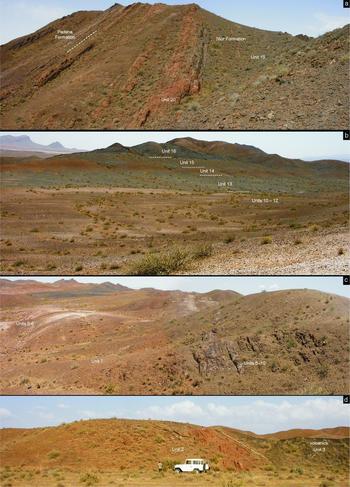
Field photographs of the section of the Niur Formation, Derenjal Mountains, east-central Iran. (a) Upper part (units 19 and 20, Hill C) of the section and the boundary between the Niur (Silurian) and the overlying Padeha (Devonian) formations; dashed line indicates base of the lowermost white quartzitic bed of the Padeha Formation. (b) Upper part of Hill B (units 10 to 12) and lower part of Hill C (units 13 to 16), view from the north. (c) Hill B, units 5 to 10, view from the west. (d) General view of the basal part of the section (Hill A, units 2 and 3).

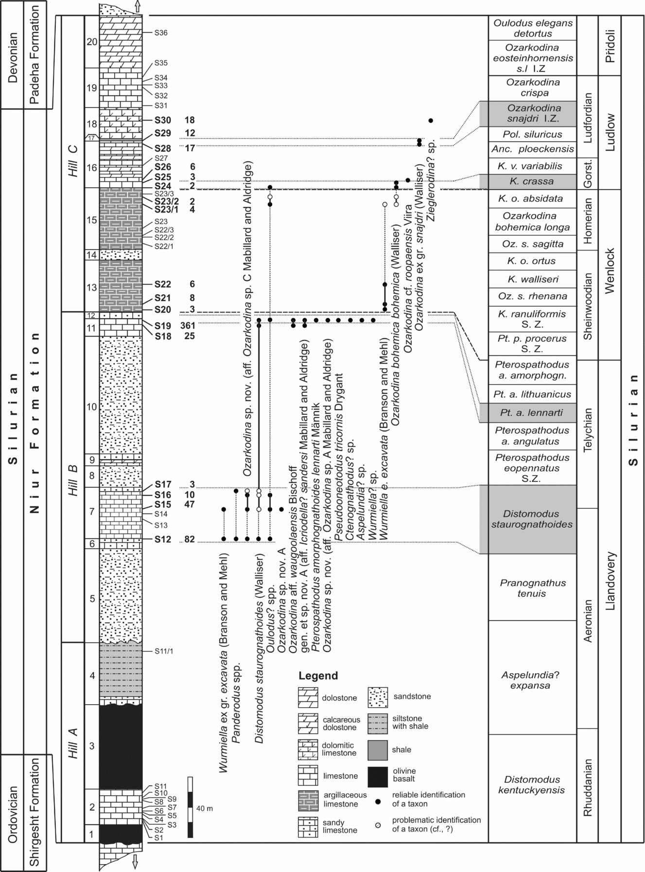
Studied section and distribution of conodonts. From left to right: systems, formations; hills where a particular interval of the section was studied; described units; lithological log (arrows below and above the log indicate that the section continues in both directions); locations and numbers of samples processed for conodonts (numbers in bold – samples that yielded conodonts); number of specimens in a sample; distribution of conodonts; conodont zones (after Cramer et al. Reference Cramer, Brett, Melchin, Männik, Kleffner, McLaughlin, Loydell, Munnecke, Jeppsson, Corradini, Brunton and Saltzman2011b ) and general stratigraphy (Stage, Series, System). Grey boxes in the column of conodont zonation indicate zones (part of) which were recognized in the studied section. Abbreviations: Pt. – Pterospathodus; a. –amorphognathoides; p. – pennatus; K. – Kockelella; Oz. – Ozarkodina; s. – sagitta; o. – ortus; v. – variabilis; Anc. – Ancoradella; Pol. – Polygnathoides; S. Z. – Superzone; I. Z. – Interval Zone; Gorst. – Gorstian.

2. Materials and methods
Forty-two samples were collected by V. Hairapetian during fieldwork in 2004 and 2007. Only calcareous intervals of the section were sampled and processed, with 17 samples yielding conodonts (Fig. 3). Sample weight varied between 0.5 and 3 kg and the number of specimens per productive sample from 2 to 361. All samples were dissolved in buffered 10% acetic acid and the residues washed through a 15.6 μm sieve. All residues were picked completely; heavy liquid separation techniques were not applied. Illustrated specimens were gold-palladium coated and photographed using a Phillips XL-30 scanning electron microscope at the Natural History Museum, London. All material is deposited at the Department of Palaeontology, Natural History Museum (prefix NHMUK PM X). Where conodont apparatus structure and therefore biological positioning of elements at generic level is proven from natural assemblages, the P1, P2, M, S0-X notation outlined by Purnell, Donoghue & Aldridge (Reference Purnell, Donoghue and Aldridge2000) is followed. When there is no evidence for homology between different element types, the traditional Pa, Pb, M, Sa, Sb, Sc notation has been followed.
3. Geographical and geological setting
The Niur Formation was formally established by Ruttner, Nabavi & Hajian (Reference Ruttner, Nabavi and Hajian1968). In the studied section, the Niur Formation is underlain by fossiliferous limestone of the Shirgesht Formation of Early to Middle Ordovician age and overlain by the siliciclastic Padeha Formation of presumed Early Devonian age. The type section of the Niur Formation is located in the vicinity of Niur village in the Ozbak-Kuh Mountains, c. 90 km northeast of the section discussed in this paper. The section studied here in the Derenjal Mountains was referred to as the ‘reference section’ of the Niur Formation by Ruttner, Nabavi & Hajian (Reference Ruttner, Nabavi and Hajian1968). There are considerable lithological differences between these two sections. The sandstone members (units 5, 8, 10, 14) recognized in the section in the Derenjal Mountains (Fig. 3) are missing in the type section of the Niur Formation in the Ozbak-Kuh Mountains. The faulted Ordovician–Silurian contact is overlain by dolostones followed mainly by coral-bearing limestones higher in the type section (Ruttner, Nabavi & Hajian, Reference Ruttner, Nabavi and Hajian1968). However, contrary to the original description of the section in the Derenjal Mountains by Ruttner, Nabavi & Hajian (Reference Ruttner, Nabavi and Hajian1968), the lower contact of the Niur Formation is also faulted (Bruton, Wright & Hamedi, Reference Bruton, Wright and Hamedi2004; Ghobadi Pour et al. Reference Ghobadi Pour, Williams, Vannier, Meidla and Popov2006).
In the Derenjal Mountains, the Silurian is exposed on three major hills: A, B and C (Figs 2, 3). A general description of the section is provided below.
3.a. Hill A (units 1–4: 135.70 m)
Base of the section. Lowermost part of the northern slope of Hill A; co-ordinates: 34°05′8.3″N and 56°48′14.0″E; altitude: 1072 m. Description of the section starts from the base of a bed of olivine basalt, from the level tentatively correlated with the Ordovician–Silurian boundary.
Unit 1. 12.80 m. Altered dark green massive olivine basalt.
Unit 2. 23.50 m. Brown to grey, medium- to thin-bedded bioclastic packstone and grainstone with a bed of brown re-crystallized limestone at the top. Corals, brachiopods, ostracods and trilobites occur. Conodont samples (all levels are measured from the base of Unit 2; Fig. 3): S1, 3.20 m; S2, 4.10 m; S3, 4.40 m; S4, 7.10 m; S5, 8.40 m; S6, 9.10 m; S7, 10.70 m; S8, 16.10 m; S9, 16.80 m; S10, 17.70 m; S11, 21.00 m.
Unit 3. 56.40 m. Altered dark green massive olivine basalt.
Top of Unit 3. Co-ordinates 34°05′07.0″N and 56°48′13.9″E; altitude 1077 m.
The measured section continues about 600 m to the east of Hill A. The upper boundary of Unit 3 was traced to this point.
Location of the base of Unit 4. 34°05′12.4″N and 56°48′39.6″E; altitude 1071 m.
Unit 4. 43.00 m. Intercalation of siltstone and silty shale. The rock is reddish brown and yields brachiopods, corals and rare trilobite fragments. At the base of the unit lies a bed of sandy limestone. Sample S11/1 comes from a level 35.80 m above the base of the unit. The upper boundary of Unit 4 (the top of Hill A) is probably faulted.
3.b. Hill B (units 5–12: 219.30 m)
The section continues on Hill B, which is to the south of Hill A. The valley separating these two hills is covered by alluvium.
Base of the strata exposed on Hill B. Co-ordinates 34°5′2.9″N and 56°48′14.0″E; altitude 1040 m.
Top of the section. Co-ordinates 34°04′56.1″N and 56°48′14.8″E; altitude 1082 m.
Unit 5. 63.00 m. White medium- to thin-bedded sandstone (quartz arenite) with cross-bedding and fine lamination in some intervals. An interval of brown sandstone occurs in the middle part of the unit.
Unit 6. 6.70 m. Brown thin-bedded sandy limestone. Silicified brachiopods (mostly unstudied spiriferids) are quite common. Conodont sample: S12, 6.50 m above the base of the unit.
Unit 7. 33.80 m. Grey to brown, medium- to thin-bedded bioclastic packstone and grainstone rich in brachiopods, corals, bryozoans, orthoconic nautiloids and tentaculites. The uppermost beds of the unit are represented by sandy limestone. Conodont samples (all levels are measured from the base of Unit 7): S13, 13.00 m; S14, 16.30 m; S15, 19.40 m; S16, 28.50 m; S17, 31.00 m. Macrofossils Mesoleptostrophia (Mesoleptostrophia) sp., Isorthis (Ovalella) inflata Popov, Modzalevskaya & Ghobadi Pour, Dalejina? rashidii Popov, Modzalevskaya & Ghobadi Pour, Stegocornu denisae Popov, Modzalevskaya & Ghobadi Pour, Rhyidorhachis? sp., Stegorhynchus? sp., Hercotrema sp. and Striispirifer? ocissimus Popov, Modzalevskaya & Ghobadi Pour were identified from sample S14 (Hairapetian et al. Reference Hairapetian, Ghobadi Pour, Popov and Modzalevskaya2012).
Unit 8. 14.20 m. White medium- to thin-bedded allochemic sandstone. At some levels poorly preserved brachiopods occur.
Unit 9. 7.80 m. Intercalation of brown medium- to thin-bedded sandy limestone and dolomitic limestone. Rare fragments of brachiopods have been found.
Unit 10. 77.70 m. White medium- to thin-bedded allochemic sandstone. At some levels poorly preserved brachiopods occur.
Unit 11. 11.70 m. Grey thin-bedded bioclastic mudstone, wackestone and grainstone with brachiopods and corals. At the top of the unit, a ~ 0.15 m thick bed of yellow biodetrital limestone with relatively coarse lithoclasts occurs. Conodont samples (both levels are measured from the base of Unit 11): S18, 7.80 m; S19, 10.70 m.
Unit 12. 4.40 m. Brown to red sandy limestone.
3.c. Hill C (units 13–20: 196.30 m)
The section continues without a gap in the succession to Hill C.
Base of the section on Hill C. Co-ordinates 34°04′49.8″N and 56°48′6.4″E; altitude 1078 m.
Top of section. Co-ordinates 34°04′44.6″N and 56°48′7.3″E; altitude 1069 m.
Unit 13. 34.20 m. Highly fossiliferous bioclastic dark grey thin-bedded argillaceous wackestone and packstone. Conodont samples (all levels are measured from the base of Unit 13): S20, 1.30 m; S21, 4.90 m; S22, 18.10 m.
Unit 14. 7.00 m. Brown medium- to thin-bedded partly calcareous (dolomitic?) sandstone.
Unit 15. 40.80 m. Grey medium- to thin-bedded argillaceous bioclastic limestone (mudstone, wackestone, packstone and grainstone) with brachiopods and corals. Conodont samples (all levels are measured from the base of Unit 15): S22/1, 4.15 m; S22/2, 8.20 m; S22/3, 9.00 m; S23, 13.80 m; S23/1, 30.20 m; S23/2, 34.90 m; S23/3, 36.70 m; S24, 40.80 m. Samples S22 and S23 contain brachiopods Isorthis sp. sensu lato and some rhynchonellids.
Unit 16. 31.00 m. Grey thin- to medium-bedded bioclastic packstone with brachiopods and dolostone interbeds. Two beds rich in corals, possibly with algae and bryozoans, occur in intervals 6.00–6.20 m and 11.30–11.45 m above the base of the unit. Additionally, a 0.20 m thick bed of coral limestone was observed in the interval 7.90–8.10 m above the base. Conodont samples (all levels are measured from the base of Unit 16): S25, 3.10 m; S26, 5.00 m; S27, 14.30 m; S28, 29.20 m.
Unit 17. 1.50 m. Grey to yellow thin-bedded fossiliferous marlstone.
Conodont sample S29 is from 0.15 m above the base of the unit.
Unit 18. 20.50 m. Grey thin- to medium-bedded dolomitic bioclastic packstone. The sample S30 comes from 12.10 m above the base of the unit.
Unit 19. 26.20 m. Grey thin- to medium-bedded limestone with crinoids, brachiopods and corals. Conodont samples (all levels are measured from the base of Unit 19): S31, 1.30 m; S32, 8.80 m; S33, 10.10 m; S34, 12.10 m; S35, 19.70 m. Sample S31 contains unidentified spiriferids and rhynchonellids; a bed 3 m above sample S31 yields some unidentified rhynchonellids, atrypids and spiriferids; in sample S35 brachiopods Lyssatrypa sp. and also some athyridides were found.
Unit 20. 35.10 m. Brown medium-bedded more or less calcareous dolostone with some sand in the uppermost beds. Some poorly preserved brachiopods and corals(?) occur at the base of the unit. Sample S36 was taken at 13.10 m above the base of the unit. In the upper part of the section, the boundary between the Niur Formation and the overlying white quartzite of the Padeha Formation is conformable and transitional.
4. Age of the Niur Formation
4.a. Conodonts
Based on conodonts (identified by O. H. Walliser), but also on some other faunas from the Derenjal Mountains, a Llandovery to (probably) Pridoli age was suggested for the Niur Formation by Ruttner, Nabavi & Hajian (Reference Ruttner, Nabavi and Hajian1968). These conclusions were later supported by R. J. Aldridge (in Hamedi et al. Reference Hamedi, Wright, Aldridge, Boucot, Bruton, Chatterton, Jones, Nicoll, Rickards and Ross1997). Weddige (Reference Weddige1984) discussed conodonts from the Niur Formation exposed in the Huk locality in the Ozbak-Kuh Mountains and in a section in the Binalud Mountains near Mashad in NE Iran.
4.a.1. Llandovery–Wenlock
One sample studied by Ruttner, Nabavi & Hajian (Reference Ruttner, Nabavi and Hajian1968; W1119 from bed no. 12, most probably equivalent to our Unit 7) yielded Hadrognathus staurognathoides s.f. Walliser. Other taxa identified were Lonchodina sp. s.f., Neoprioniodus sp. s.f. and Ozarkodina sp. s.f. Without restudying these specimens, no valuable stratigraphical information can be obtained. However, a late Valentinian (= approximately Llandovery) to early Wenlock age suggested by Ruttner, Nabavi & Hajian (Reference Ruttner, Nabavi and Hajian1968) for this level agrees, in general, with our data. The conodont assemblage from Unit 7 (our samples S15–S17; Fig. 3) includes two undescribed taxa, Ozarkodina sp. nov. (aff. Ozarkodina sp. C Mabillard & Aldridge) (Fig. 4o) and Ozarkodina sp. nov. A (Fig. 4f), along with Distomodus staurognathoides, Wurmiella ex gr. excavata and some poorly preserved elements of Panderodus and Oulodus?. D. staurognathoides indicates that the Unit 7 limestone cannot be older than middle Aeronian and corresponds to the D. staurognathoides Zone (Loydell, Nestor & Männik, Reference Loydell, Nestor and Männik2010). W. ex gr. excavata in this unit (Fig. 4a) is morphologically quite similar to W. excavata puskuensis (Männik), an older form of the W. excavata lineage. W. e. puskuensis is known to occur in strata of late Rhuddanian and Aeronian age (Männik, Reference Männik1994). If the Wurmiella specimens in samples S12 and S15 from Unit 7 are really W. e. puskuensis, the unit (at least the lower and middle parts of it; Fig. 3) is middle to late Aeronian in age. Ozarkodina sp. C Mabillard & Aldridge has been described from the Telychian of the Marloes Bay section, SW Dyfed, Wales (Mabillard & Aldridge, Reference Mabillard and Aldridge1983). However, our specimens of Ozarkodina sp. nov. (aff. Ozarkodina sp. C Mabillard & Aldridge), although in general morphologically similar to those of Ozarkodina sp. C Mabillard & Aldridge, evidently represent another taxon which could be an older representative of the same lineage (see taxonomic discussion in Section 7 below). Hence, the conodont data suggest that the Aeronian–Telychian boundary most probably lies within Unit 7 (Fig. 3).
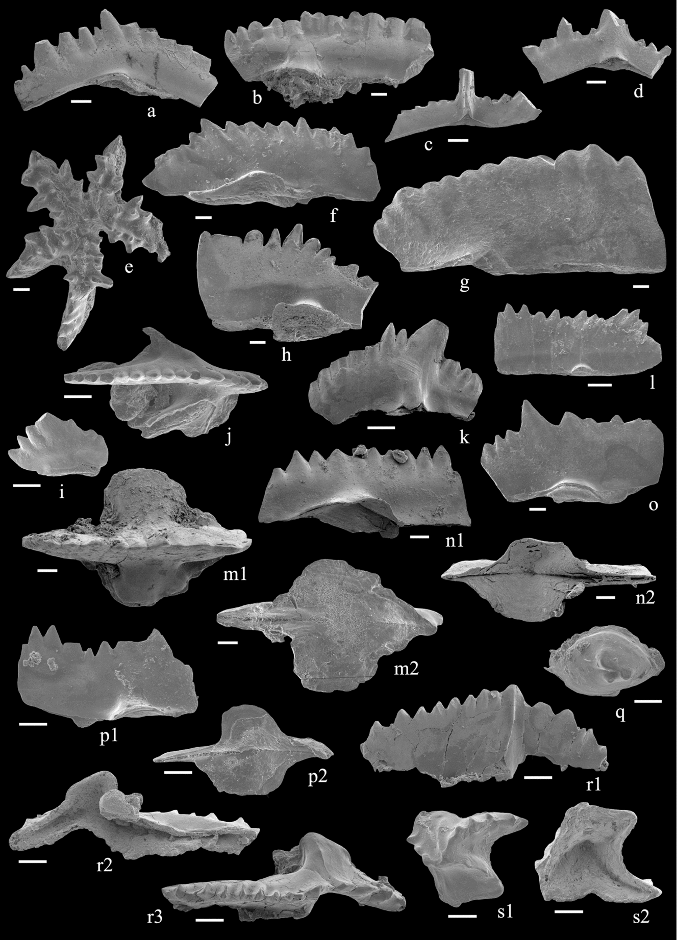
Selected conodonts from the Niur Formation. Scale bar corresponds to 0.1 mm. (a) Wurmiella ex. gr. excavata (Branson & Mehl); NHMUK PM X 3592, lateral view of P1 element, sample S15. (b–d) Wurmiella excavata; (b) NHMUK PM X 3591, lateral view of P1 element, sample S20; (c) NHMUK PM X 3593, posterior view of S1–2 element, sample S21; (d) NHMUK PM X 3594, lateral view of P2 element, sample S21. (e) Distomodus staurognathoides (Walliser); NHMUK PM X 3275, upper view of Pa element, sample S12. (f) Ozarkodina sp. nov. A; NHMUK PM X 3595, lateral view of P1 element, sample S15. (g) Ozarkodina cf. roopaensis Viira; NHMUK PM X 3271 lateral view of P1 element, sample S26. (h) Ozarkodina sp. nov. (aff. Ozarkodina sp. A Mabillard & Aldridge); NHMUK PM X 3596, lateral view of P1 element, sample S19. (i–k) Pterospathodus amorphognathoides lennarti Männik; (i) NHMUK PM X 3597, lateral view of Pb2 element; (j) NHMUK PM X 3598, upper view of Pa element; (k) NHMUK PM X 3599, lateral view of Pb1 element. All specimens from sample S19. (l) Ozarkodina aff. waugoolaensis Bischoff; NHMUK PM X 3600, lateral view of P1 element, sample S19. (m) Ozarkodina ex gr. snajdri (Walliser); NHMUK PM X 3268, upper (m1) and lower (m2) views of P1 element, sample S28. (n) Ozarkodina bohemica bohemica (Walliser); NHMUK PM X 3273, lateral (n1) and lower (n2) views of P1 element, sample S24. (o) Ozarkodina sp. nov. (aff. Ozarkodina sp. C Mabillard & Aldridge); NHMUK PM X 3601, lateral view of P1 element, sample S12. (p) Zieglerodina? sp.; NHMUK PM X 3602, lateral (p1) and lower (p2) views of P1 element, sample S30. (q) Pseudooneotodus tricornis Drygant; NHMUK PM X 3277, upper view, sample S19. (r–s) gen. et sp. nov. A (aff. I.? sandersi Mabillard & Aldridge); (r) NHMUK PM X 3603, lateral (r1), lower (r2) and upper (r3) views of Pa element; (s) NHMUK PM X 3604, upper (s1) and lower (s2) views of ‘ambalodiform’ P? element. Both specimens from sample S19.

The next samples, S18 and S19, come from the upper part of Unit 11. Sample S19 yields the richest and most abundant fauna (361 specimens) in the studied section (Fig. 3). The fauna recovered includes Pterospathodus amorphognathoides lennarti (Fig. 4i–k), D. staurognathoides, Pseudooneotodus tricornis (Fig. 4q), Ozarkodina aff. waugoolaensis (Fig. 4l), Aspelundia? sp., Wurmiella? sp., Oulodus? spp. and some poorly known or undescribed taxa: Ozarkodina sp. nov. (aff. Ozarkodina sp. A Mabillard & Aldridge) (Fig. 4h) and gen. et sp. nov. A (aff. I.? sandersi Mabillard & Aldridge) (Fig. 4r–s). Gen. et sp. nov. A (aff. I.? sandersi Mabillard & Aldridge) first appears in sample S18 (together with Ozarkodina aff. waugoolaensis) but is particularly common in S19. The occurrence of Pt. a. lennarti in S19 indicates that this sample comes from the Pt. a. lennarti Zone and is middle Telychian in age (Männik, Reference Männik2007a ; Fig. 3).
As the samples from just above Unit 12, from the lowermost and middle parts of Unit 13, yield only W. excavata excavata (Fig. 4b–d), a taxon characteristic of Sheinwoodian and younger strata, it seems most probable that the Llandovery–Wenlock boundary in the section should be placed between samples S19 and S20. Lack of any other taxa in the lowermost part of Unit 13 indicates that S20 comes from a level above the last datum of the Ireviken Event (= the level of extinction of D. staurognathoides; Jeppsson, Reference Jeppsson, Landing and Johnson1998), i.e. well above the Llandovery–Wenlock boundary (Männik, Reference Männik2007b ). In this paper, the Llandovery–Wenlock boundary is tentatively drawn at the boundary between units 12 and 13, at a level where sandy limestone of Unit 12 is replaced by argillaceous limestone of Unit 13. Conodonts currently available do not allow precise dating of the strata just above this level. As a result, the base of Unit 13 up to the upper part of Unit 15 is tentatively correlated with the Wenlock in this paper (Fig. 3).
4.a.2. Wenlock–Ludlow
The conodont sample studied by Ruttner, Nabavi & Hajian (Reference Ruttner, Nabavi and Hajian1968; W1155 from bed 28) probably corresponds to a level within our Unit 19. Spathognathodus steinhornensis subsp. indet. s.f. Walliser, Ozarkodina denckmanni s.f. Ziegler, Lonchodina greilingi s.f. Walliser, Oz. media s.f. Walliser, Trichonodella inconstans s.f. Walliser, Neoprioniodus primus s.f. (Branson & Mehl), S. primus s.f. (Branson & Mehl) and Lonchodina sp. A s.f. were identified in this sample by O. H. Walliser. Based on this assemblage, a late Ludlow to earliest Devonian age was suggested, with a proviso that it was probably latest Ludlow (Ludfordian) in age. In modern terminology, the assemblage probably included Oz. confluens (Branson & Mehl), W. excavata and Oulodus? sp. Assignment of elements identified as S. steinhornensis subsp. indet. s.f. to any known apparatus is more complicated. It is most probably a representative of the Oz. steinhornensis s.l. ‘group’ appearing in most known successions in the late Ludfordian. More material needs to be found and studied to decide if it belongs to Zieglerodina or to Genus W eosteinhornensis (Walliser) sensu Murphy, Valenzuela-Ríos & Carls (Reference Murphy, Valenzuela-Ríos and Carls2004).
All samples processed by us from Unit 19 were barren. The uppermost conodont in our collection Zieglerodina? sp. (Figs 3, 4p) comes from sample S30, from the middle part of Unit 18. Zieglerodina, which first appears in the uppermost Ludlow, is more characteristic of the Pridoli and particularly of the lowermost Devonian (Carls, Slavik & Valenzuela-Ríos, Reference Carls, Slavík and Valenzuela-Ríos2007). As a result, our material does not allow improved dating of the uppermost part of the studied section but it does not contradict the conclusions of Ruttner, Nabavi & Hajian (Reference Ruttner, Nabavi and Hajian1968).
Based on our collections, two other intervals in the studied section can be dated precisely. Oz. bohemica (Figs 3, 4n) has been identified from the lowermost part of Unit 16, and probably from the uppermost beds of Unit 15. At least two chronological subspecies are known in the Oz. bohemica lineage: Oz. b. longa Jeppsson characteristic of the upper Wenlock (Homerian) and Oz. b. bohemica occurring in the lowermost Ludlow (in the lowermost Gorstian; Jeppsson & Aldridge, Reference Jeppsson and Aldridge2000; Calner & Jeppsson, Reference Calner and Jeppsson2003; Jeppsson, Eriksson & Calner, Reference Jeppsson, Eriksson and Calner2006). The P1 element of Oz. b. longa is relatively long and low, whereas that of Oz. b. bohemica is shorter and higher. However, variation in these dimensions is only distinct in larger collections, particularly in those containing many specimens of Oz. b. longa. As a result, when only a small number of specimens are available, it is often difficult to tell which subspecies is present. Only two well-preserved P1 elements from samples S24 and S25 (Fig. 3) have been recovered from the Niur Formation. However, as only short and high specimens with large basal cavities (Fig. 4n) occur, it seems most probable that our specimens belong to Oz. b. bohemica. In this case, the lowermost part of Unit 16 is earliest Ludlow (earliest Gorstian) in age and correlates with a level in the Kockelella crassa Zone (Fig. 3). Specimens of Oz. bohemica from samples S23/1 and S23/2 are too poorly preserved to allow subspecies identification.
In sample S26, in the next productive sample above the level yielding the uppermost Oz. b. bohemica, six poorly preserved specimens of robust Ozarkodina were found (Figs 3, 4g). Morphologically they seem to be closest to Oz. roopaensis, which occurs in the Paadla Stage in the Baltic (Gorstian to lower Ludfordian) corresponding to an interval from the K. crassa Zone to the Oz. snajdri Interval Zone (Viira, Reference Viira1994; Cramer et al. Reference Cramer, Davies, Ray, Thomas, Cherns and Ray2011a ). Two samples (S28 and S29) from the topmost beds of Unit 19 yield 29 specimens of Oz. ex gr. snajdri (Figs 3, 4m), a taxon characteristic of the middle to late Ludlow (Corradini & Serpagli, Reference Corradini and Serpagli1999; Viira, Reference Viira1999).
From the data presented above, it is evident that Unit 16 in the studied section corresponds to an interval from the lower(most) Gorstian to the middle Ludfordian. Tentatively, the Wenlock–Ludlow boundary in the section is placed at the boundary between units 15 and 16 (Fig. 3). However, as units 13, 14 and 15 cannot be reliably dated, the boundary could be at a lower level in the section. Rugose corals from units 13 and 15 suggest a Ludlow age for these strata (Section 4.b). Based on currently available data, it is not possible to locate the Ludlow–Pridoli boundary in the section.
4.b. Other faunas
Dating of the Niur Formation based on other fossils is consistent with the results of the conodont studies. Rugose and tabulate corals, stromatoporoids, brachiopods and ostracods are common in the studied section. Flügel & Saleh (Reference Flügel and Saleh1970) studied the diverse but mostly endemic rugose faunas in detail. From the outcrops on Hill A (units 2 and 4) and the middle part of Hill B (Unit 7), they identified Grewingkia alternata Saleh, Paliphyllum (Paliphyllum) oblongaecystosum Saleh, Schlotheimophyllum sp., Streptelasma shirgeshtensis Saleh, S. ruttneri Saleh and Tryplasma sp., suggesting a Llandovery age for these strata (Flügel & Saleh, Reference Flügel and Saleh1970). Characteristic Ludlow taxa were reported on Hill C from Unit 19 (beds 27–30 in Ruttner, Nabavi & Hajian, Reference Ruttner, Nabavi and Hajian1968), Cystiphyllum (Holmophyllum) pauciseptatum Flügel & Saleh, and from units 13 and 15 (beds 24 and 26), Gyalophyllum (Coronoruga) sp.
From Hill A, units 2 and 4, Hubmann (Reference Hubmann1991a ) described tabulate corals of Llandovery age, including Eocatenipora nicholsoni Kiaer, Catenipora obliqua Fischer-Benzon, C. micropora Whitfield, C. gotlandica Yabe, C. cf. louisvillensis Stumm, C. cf. jarviki Stasinska, C. khorasanensis Hubmann and Halysites labyrinthicus Goldfuss. The Llandovery stromatoporoid Ecclimadictyon pseudofastigiatum (Riabinin) described by Flügel (Reference Flügel1969) most probably comes from the lower part of Unit 4 exposed in an outcrop on the western side of the Dahaneh-e-Kolut Gorge. Another stromatoporoid, Clathrodictyon pustulatum Yavorsky, was identified by him from units 13 and 15 (beds 24 and 26). Ostracods Pachydomella wolfei Copeland, Steusloffina cuneata (Steusloff), Arcuaria? triangulata Neckaja and Punctobeecherella punctata Copeland in association with pentamerid brachiopods from Unit 2 suggest a mid Aeronian age for this unit (Hairapetian et al. Reference Hairapetian, Mohibullah, Tilley, Williams, Miller, Afzal, Ghobadi Pour and Hassan Hejazi2011).
The Stegocornu brachiopod association including the key rhynchonellid taxon Stegocornu denisae Popov, Modzalevskaya & Ghobadi Pour was collected from sample S14 (Unit 7) (Hairapetian et al. Reference Hairapetian, Ghobadi Pour, Popov and Modzalevskaya2012). The dispersion of Stegocornu association brachiopods in Central Iran, Kope-Dagh and Afghanistan represents a significant Aeronian regional event (Hairapetian et al. Reference Hairapetian, Ghobadi Pour, Popov and Modzalevskaya2012).
5. Palaeogeographic affinities of faunas
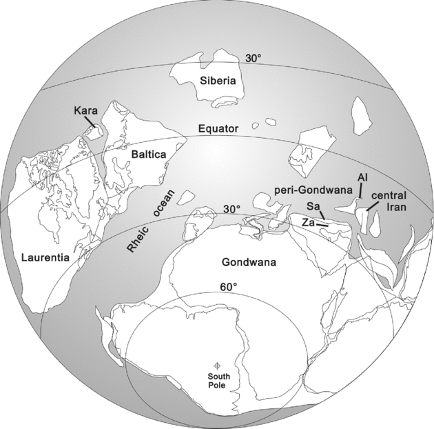
Based on the palaeogeographic reconstruction of Cocks & Torsvik (Reference Cocks and Torsvik2002, fig. 8) for the late-Early Silurian – Late Silurian, the Iranian terranes, including Central Iran (Lut), Alborz, Sanand and Zagros terranes, were located between palaeolatitudes 15° and 30°S, and formed part of Middle Eastern peri-Gondwanan/Gondwanan terranes (Fig. 5). East of modern Central Iran, a vast shallow-water shelf with a dominant carbonate-siliciclastic sedimentation regime developed in the Silurian. During the Llandovery, the Zagros and probably Sanand terranes (located SW of the Central Iran terrane) were attached to the northern margin of Gondwana. These regions have a similar sedimentological and biological history to the Arabian domain (Lüning et al. Reference Lüning, Craig, Loydell, Štorch and Fitches2000; Rickards, Wright & Hamedi, Reference Rickards, Wright and Hamedi2000; Wendt et al. Reference Wendt, Kaufmann, Belka, Farsan and Karimi Bavandpur2002, Reference Wendt, Kaufmann, Belka, Farsan and Karimi Bavandpur2005; Ruban, Al-Husseini & Iwasaki, Reference Ruban, Al-Husseini and Iwasaki2007; Ghavidel-Syooki & Winchester-Seeto, Reference Ghavidel-syooki, Winchester-Seeto, Laurie and Foster2004; Ghavidel-Syooki et al. Reference Ghavidel-syooki, Álvaro, Popov, Ghobadi Pour, Ehsani and Suyarkova2011).
Palaeogeographic position of Iranian terranes during the Early Silurian (Llandovery). Base map from Cocks & Torsvik (Reference Cocks and Torsvik2002), with modifications. Abbreviations: Al. – Alborz; Sa. – Sanand; Za. – Zagros. (Modified from Hairapetian et al. Reference Hairapetian, Blom and Miller2008 with permission from Acta Palaeontologica Polonica).

Despite the peri-Gondwanan setting of Central Iran (according to the palaeogeographic reconstructions of Cocks & Torsvik, Reference Cocks and Torsvik2002), and its considerable distance from the low-latitude Laurentia and Baltica in the Silurian (Fig. 5), ostracods from the lower Niur Formation (from Unit 2) have strong Laurentian affinities. Taxa include Pachydomella wolfei, Steusloffina cuneata, Arcuaria? triangulata, Punctobeecherella punctata and several species of the genera Elliptocyprites, Punctaparchites, Aechmina, Dicranella, Lomatopisthia and Ovornina (Hairapetian et al. Reference Hairapetian, Mohibullah, Tilley, Williams, Miller, Afzal, Ghobadi Pour and Hassan Hejazi2011). The ostracod fauna has some similarities to Baltic Palaeocontinent Late Ordovician – Early Silurian faunas. Common taxa include A.? triangulata, S. cuneata and several species of Bairdiocypris, Bulbosclerites and Aechmina (Neckaja, Reference Neckaja1958; Meidla, Reference Meidla1996). Some taxa (S. cuneata, Bairdiocypris attenuatus Melnikova & Michailova), characteristic of the lower Niur Formation, have also been reported from Uzbekistan (Melnikova & Michailova, Reference Melnikova and Michailova1999).
Assemblages of halysitid corals, particularly representatives of the genus Catenipora from the Niur Formation, also suggest palaeobiogeographic affinities with faunas known from the Laurussian terranes (Hubmann, Reference Hubmann1991a ,Reference Hubmann b ; Flügel & Hubmann, Reference Flügel and Hubmann1993).
Palaeogeographical distribution data of Niur Formation conodonts do not contradict any of the palaeogeographical conclusions based on other fossil groups. Poorly known conodont taxa in the Llandovery part of the studied section means that limited conclusions can be drawn at these levels. Conodonts occurring in units 7 and 11, such as Ozarkodina sp. nov. (aff. Ozarkodina sp. C Mabillard & Aldridge) (Fig. 4o), Ozarkodina sp. nov. (aff. Ozarkodina sp. A Mabillard & Aldridge) (Fig. 4h) and gen. et sp. nov. A (aff. I.? sandersi Mabillard & Aldridge) (Fig. 4r–s) seem to be restricted to this geographical region. However, their possible closest relatives are known from Avalonia on the other side of the Rheic Ocean in the Marloes Bay section, SW Dyfed, Wales (Mabillard & Aldridge, Reference Mabillard and Aldridge1983). Many of the other conodont taxa found in the Llandovery part of the studied section (e.g. D. staurognathoides, Pseudooneotodus tricornis) are cosmopolitan. The distribution of Pt. a. lennarti is less well known, but based on data available, this taxon (as Pt. amorphognathoides in general) is also cosmopolitan (Männik, Reference Männik1998). Conodonts are rare in strata of Wenlock and younger age in the studied section, but all taxa recognized are known away from Gondwana (Fig. 3).
The data above suggest that for many taxa the Rheic Ocean separating Gondwana from Laurussia was not a major barrier. Conodonts from the Tafilalt region of Morocco have also supported this hypothesis (Männik, Loydell & Lubeseder, Reference Männik, Loydell and Lubeseder2011). Tafilalt conodonts from the lowermost Tamaghrout Formation (lowermost Wenlock), from the strata corresponding to the Pt. pennatus procerus Superzone sensu Jeppsson (Reference Jeppsson1997) are identical to Baltica palaeocontinent conodonts from the same interval. The description of the typical Baltic thelodont Loganellia cf. grossi Fredholm in units 16 and 19 in the studied Niur Formation section also suggests that there were migration paths between Gondwana and Laurussia (Hairapetian, Blom & Miller, Reference Hairapetian, Blom and Miller2008).
6. Conclusions
(1) Conodonts and other fossil groups suggest a Llandovery to Ludlow age for the Niur Formation. However, currently available faunas do not allow dating of the strata above Unit 16.
(2) Unit 7 is either of Aeronian or Telychian in age.
(3) Unit 11 (at least its upper part) is of middle Telychian in age and corresponds to the Pt. a. lennarti Zone.
(4) The Llandovery–Wenlock boundary lies between samples S19 and S20 and is tentatively drawn as corresponding to the boundary between units 12 and 13.
(5) The lowermost part of Unit 16 is of earliest Ludlow in age and corresponds to the Kockelella crassa Zone.
(6) The Wenlock–Ludlow boundary lies below Unit 16 and is tentatively drawn at the boundary between units 15 and 16. However, as units 13, 14 and 15 cannot be reliably dated, it cannot be excluded that the boundary lies at a lower level in the section.
(7) The uppermost Unit 16 is of late Ludlow (Ludfordian) age and corresponds to the Oz. snajdri Interval Zone.
(8) Although the latest palaeogeographical reconstruction shows that present-day Iran was located far away from Baltica and Laurentia, on the other side of the Rheic Ocean, this seems not to have been a major migration barrier for many different organisms including the conodonts.
7. Comments on some taxa
Brief comments on some taxa in open nomenclature are given. A description of conodonts from the Derenjal section will be presented in another paper; key taxa are illustrated in Figure 4.
Genus Ozarkodina Branson & Mehl, Reference Branson and Mehl1933
Ozarkodina sp. nov. (aff. Ozarkodina sp. C Mabillard & Aldridge)
Figure 4o
Remarks. P1 elements of the apparatus identified here as Ozarkodina sp. nov. (aff. Ozarkodina sp. C Mabillard & Aldridge) bear some similarity to those described by Mabillard & Aldridge (Reference Mabillard and Aldridge1983, pl. 3, figs 9, 10) as Ozarkodina sp. C. However, our specimens differ by having shorter and higher blades and less prominent cusps.
Ozarkodina sp. nov. (aff. Ozarkodina sp. A Mabillard & Aldridge)
Figure 4h
Remarks. P1 elements of Ozarkodina sp. nov. (aff. Ozarkodina sp. A Mabillard & Aldridge) resemble Ozarkodina sp. A of Mabillard & Aldridge (Reference Mabillard and Aldridge1983, pl. 3, figs 7, 8) in general configuration only. Both taxa have short P1 elements with a high ventral blade and denticles on the dorsal blade that rapidly decrease in height from the cusp. Morphological differences are evident between these two taxa. According to Mabillard & Aldridge (Reference Mabillard and Aldridge1983), the Pa (= P1) element of Ozarkodina sp. A has 3–4 short, erect, broad denticles of subequal size on its ventral blade whereas our specimens have relatively small denticles with one considerably larger denticle in the ventralmost part of the blade. The cusp of Ozarkodina sp. A is broad and distinct whereas our specimens have cusps that do not differ in size from the other denticles. The P1 element basal cavity of Ozarkodina sp. nov. (aff. Ozarkodina sp. A Mabillard & Aldridge) is shorter but more strongly flared than in Ozarkodina sp. A.
gen. et sp. nov. A (aff. I.? sandersi Mabillard & Aldridge)
Figure 4r–s
Remarks. According to the original description, the apparatus of I.? sandersi contains a straight thin-walled broad-based P element with icriodelliform denticulation on its anterior process, an incurved M element with prominent anticusp and denticulated posterior process, a sagittodontiform ‘S’ element, and symmetrical to asymmetrical delicate Sa–Sb elements (Mabillard & Aldridge, Reference Mabillard and Aldridge1983, p. 33). A similar suite of elements can be recognized in our gen. et sp. nov. A apparatus, along with an ‘ambalodiform’(?) element of distinct morphology (Fig. 4s). This additional element has quite well-developed ‘icriodelliform’ denticulation on its processes. This element is missing in the 247 specimen collection of I.? sandersi described by Mabillard & Aldridge (Reference Mabillard and Aldridge1983). The apparatus of I.? sandersi is evidently icriodelliform whereas that of gen. et sp. nov. A (aff. I.? sandersi Mabillard & Aldridge) represents another, more complicated apparatus type.
Acknowledgements
V. Hairapetian was assisted by Drs Leonid E. Popov and Mansoureh Ghobadi Pour in the field. Constructive reviews were provided by two anonymous referees. The study of P. Männik was supported by the Estonian Science Foundation (grant no. 8907). His visit to the NHM in March 2010, and the use of the SEM to study conodonts, was financed by the SYNTHESYS Project GB-TAF-294.