Introduction
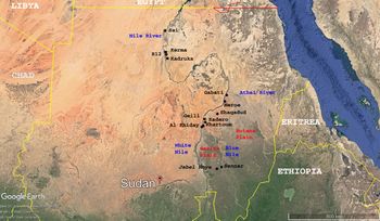
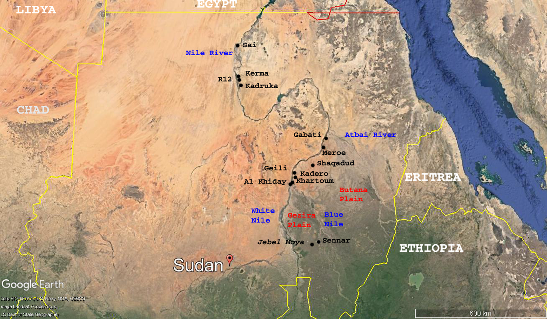
This report presents the current state of knowledge about Jebel Moya, Sudan, after two seasons of excavations (2017, 2019). Jebel Moya (Mountain of Water) is located c. 250 km south-south-east of Khartoum in south-central Sudan (Fig. 1). The Jebel Moya mountain range has numerous valleys. The site of Jebel Moya is located in the mountain range's north-east valley. The valley is 10.4 hectares and there are traces of archaeological activity across the area. Around a fifth was excavated by the Henry Wellcome expedition in the early twentieth century (for a discussion on archaeology below the Sixth Cataract and Henry Wellcome's project, see Vella Gregory Reference Vella Gregory2020), but over half of the remaining area contains substantial unexcavated and viable archaeological deposits. The study of this site has to date encompassed substantial work on existing collections and archives. As noted in Vella Gregory (Reference Vella Gregory2020) and Brass (Reference Brass2016, 3–5), despite building a vast camp and running it along military lines, Wellcome's work was not particularly meticulous or well recorded. For many reasons, there were only four seasons of excavations, between 1911 and 1914. Wellcome had briefly employed the services of Egyptologist George Reisner, who viewed the site through the lens of Egyptian and Nubian material. This view would dominate Sudanese archaeology for many years and Jebel Moya was largely ignored by archaeologists (for exceptions see Brass Reference Brass2016, 6–9).
Jebel Moya (Gezira plain, south-central Sudan) in relation to other major sites of the Sudan (Landset image copyright courtesy of the US Dept of State Geographer).
An examination of curated material remains and archives relating to Wellcome's expedition highlighted two important points. First, the site had enormous potential for further work and second, very little was known about Wellcome's expedition bar the carefully curated promotional material during his lifetime and, eventually, reports by Addison (Reference Addison1949) and Mukherjee et al. (Reference Mukherjee, Rao and Trevor1955). From the outset, it was decided that the project would be a full collaboration with Sudanese archaeologists and that it would involve the local community. To that end, the project is jointly directed by Michael Brass (University College London, UCL) and Ahmed Adam (University of Khartoum, UoK).
The curated material and archives gave strong indications that Jebel Moya is a key site on the Gezira plain. It is the largest habitation and mortuary site in sub-Saharan Africa, and is situated in the eastern Sahel belt, the belt being part of a corridor of movement of peoples, animals and cereals (see González-Ruibal and Falquina Reference González-Ruibal and Falquina2017; Winchell et al. Reference Winchell, Brass, Manzo, Beldados, Perna, Murphy, Stevens and Fuller2018). Earlier, Caneva (Reference Caneva1991) had hypothesized that the late sixth millennium BC sherds curated at the British Museum indicated connections through with the central Sahara. Historical sources claimed that the Meroitic State (c. 350 BC–AD 350) had obtained slaves and raw materials from south of Meroe (see Edwards Reference Edwards1996, 46; Welsby Reference Welsby1996), and nearby Sennar c. 30 km to the east of Jebel Moya along the Blue Nile had been the seat of the medieval Islamic Funj state. More widely, geological studies undertaken in the Gezira plain from the late 1970s to the early 1980s (Williams and Adamson Reference Williams and Adamson1982) pointed towards an environment which shifted from swamp-like conditions before the late sixth millennium BC, to a wet but habitable ecology and gradually increasing in aridity until present-day conditions were reached in the southern Gezira plain close on 2,000 years ago. Brass’ (Reference Brass2016) PhD research confirmed a longue durée of occupation at Jebel Moya, stretching back to the late sixth millennium BC. At the outset, it was clear that any field research would need to incorporate extensive botanical sampling and a comprehensive dating programme.
There are two important constant features. The only visible architectural remains are the House of the Boulders and two large incinerators. These were built by Henry Wellcome. The House of the Boulders was variously used as a field hospital and general headquarters. It is built out of large blocks of basalt and is visible as one is going up the mountain. The house is now part of the site's history and is presently used as a rest area by the team. It is also regularly used by neighbouring sheep herders. The other feature of the site is a series of gullies. There is one main gully; it is shallow and broad and flows from the western slopes across the valley and out through a break in the eastern slopes. It is frequently mentioned by Addison (Reference Addison1949). There are thinner but deeper gullies traversing from the north and north-west which meet the main gully before it exits the valley. References to gullies in the text are for the auxiliary gullies.
Methodology
Despite the lack of precise methodology, Wellcome's excavations revealed that the site was made up of a number of strata. This is seen in Addison's (Reference Addison1949) report, field notes by the excavators Dixon and Wainwright and Oric Bates’ personal field diary (extant field notes are curated at the Griffiths Institute, Oxford) and grave cards (curated at the Duckworth Laboratory, Cambridge). Addison (Reference Addison1949, 15) described strata A–D as follows:
Stratum A. Top soil: Dark Brown
Stratum B. Upper layer: Grey
Stratum C. Black gravel: Black
Stratum D. Black gebel: Black
The terminology has been retained for the sake of continuity, although from the outset our excavation proceeded at 10 cm spit intervals. The 2017 excavations confirmed the lack of visible micro-stratigraphy across the five excavated trenches (Brass et al. Reference Brass, Adam, Fuller, Stevens, Hassan, Kozierdazka-Ogunmakin, Abdallah, Alawad, Abdallah, Wellings and Abdelrahman2018a, Reference Brass, Adam, Fuller, Stevens, Hassan, Kozierdazka-Ogunmakin, Abdallah, Alawad, Abdalla, Wellings and Abdelrahmanb), while four broad geological strata were discerned. It is an observation reconfirmed in the 2019 season and also by examining the geological strata in the deepest gully nearby Trench 2, which displays a clear archaeological sequence. Excavating in small spits ensured a measure of control. Bearing in mind that each stratum can vary in depth, excavating only by following a stratum would have hampered investigation. The 2017 season confirmed Addison's descriptions of strata A and B, but Stratum C was observed to be light brown when first exposed and quickly becoming dark grey, while Stratum D is a mid-dark grey that also turns darker. The change in stratum does not correspond to any chronology except in the broadest possible sense: the artefacts found in situ in Stratum D are from the late sixth millennium BC, while dated remains from Stratum C are from the early-mid and late third millennium BC and the pottery from the stratum is distinct from the preceding and subsequent strata. Finally, the pottery from strata A and B are similar and dating is currently placing these two strata in the first millennium BC.
Stratum A is subject to extensive contamination up to depths of about 25 cm below the ground surface, as recorded in 2017 and 2019. As noted via archival research, Wellcome's camp covered an extensive part of the site. The camp was essentially a tent village that included incinerators and sanitation facilities, resulting in extensive disturbance over a large part of the site's north-west sector. Wellcome's excavations across the south, east and parts of the north-east sectors removed significant archaeological deposits, usually down to bedrock. The central part of the valley is separated from the southern area by a large knoll (rock) and a west-east wide but not deep gully bisection. There are north and north-west to south and south-eastern gullies of varying depths joining up to the main gully, which exits through a gap in the valley's eastern hill.
The first field season revealed an extensive occupation dating back to at least the late sixth millennium BC. Furthermore, it yielded AMS dates on three domesticated Sorghum bicolour husks, bracketing them in the mid-third millennium BC (Brass et al. Reference Brass, Fuller, Macdonald, Stevens, Adam, Kozieradzka-Ogunmakin, Abdallah, Alawad, Abdalla, Vella Gregory, Wellings, Hassan and Abdelrahman2019, Table 4). Further dates were obtained on animal remains and a Ziziphus endocarp from trenches 2 and 4, spanning strata B and C. Finally, there is a developing pottery sequence of three assemblages which has a broad correlation with the geological strata: Assemblage 1 with Stratum D, Assemblage 2 with Stratum C, and Assemblage 3 with strata A and B. Initially, OSL dates were obtained from pottery curated at the British Museum (Brass Reference Brass2016). Subsequently, a new soil sample from the 2017 field season permitted a recalibration of these dates (Brass et al. Reference Brass, Fuller, Macdonald, Stevens, Adam, Kozieradzka-Ogunmakin, Abdallah, Alawad, Abdalla, Vella Gregory, Wellings, Hassan and Abdelrahman2019, Table 2). Taken together, Stratum D is bracketed to the late sixth millennium BC (Caneva Reference Caneva1991; Brass et al. Reference Brass, Adam, Fuller, Stevens, Hassan, Kozierdazka-Ogunmakin, Abdallah, Alawad, Abdalla, Wellings and Abdelrahman2018b), Stratum C from the early to late third millennium BC, and strata A and B to the first millennium BC, maybe into the first century AD (Brass et al. Reference Brass, Fuller, Macdonald, Stevens, Adam, Kozieradzka-Ogunmakin, Abdallah, Alawad, Abdalla, Vella Gregory, Wellings, Hassan and Abdelrahman2019, Tables 2 and 3). The second season continued the flotation and wet-sieving programme. Nineteen bulk sediment samples were taken from trenches 2 and 8 for phytolith analysis. A total of 20 sediment samples (786 litres, with approximately 40 litres of sediment sampled per spit) were systematically processed from trenches 2, 6 and 8 using a washover bucket method. A 250 μm mesh was used for flotation bags and a 3 mm mesh for heavy fraction. The latter returned charcoal and hopefully small seed/fruit remains. Analysis of the samples will be conducted by Professor Dorian Fuller at the archaeobotany laboratory of the Institute of Archaeology, University College London.
In the Sudan, the terms pre-Mesolithic, Mesolithic and Neolithic are widely used. We use them here for the sake of continuity in the literature. There has been much discussion over the use of European and Near Eastern terminology such as Mesolithic and Neolithic for North Africa (see Linseele Reference Linseele2010; Salvatori Reference Salvatori2012; Sadig Reference Sadig and Shiria2013). These terms are inadequate, both in Europe and the Near East and especially so in Africa. The spread of the Neolithic in the Near East and Europe occurred at very different speeds, and the so-called Neolithic package appeared much later in the process. North and Sahelian Africa follow very different trajectories. To this end, Broodbank and Lucarini (Reference Broodbank and Lucarini2019) neatly revised the terminology for Mediterranean North Africa by dividing time into Phases 1–4, free from the implications that terminologies often imply. A similar exercise is long overdue for the eastern Sahel belt. For the southern Gezira plain, this process is still in its infancy and for the time being we focus on using radiocarbon dates until such time as a full chronology has been devised.
The 2019 excavations
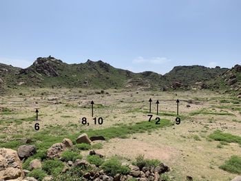
The 2019 season continued the excavation of Trench 2 and opened five new trenches (6–10) (Fig. 2). The aims were to continue carrying out systematic sampling where substantial archaeological deposits remain, build upon last season's work and to investigate more human inhumations. Trench 2 was the richest area from the previous field season, penetrating down into viable, stratigraphically coherent Neolithic layers. These yielded abundant pottery stretching from 2,000 years ago (contemporary with the northerly Meroitic state) down to the mid-third millennium BC, animal remains which offer valuable environmental data, and the second oldest domesticated sorghum yet found in the world (2575–2350 BC) (Brass et al. Reference Brass, Fuller, Macdonald, Stevens, Adam, Kozieradzka-Ogunmakin, Abdallah, Alawad, Abdalla, Vella Gregory, Wellings, Hassan and Abdelrahman2019). As the neighbouring gully shows a sequence down to and including Late Mesolithic pottery sherds at the base of the gully floor, the decision was made to resume excavating Trench 2 in an effort to reach bedrock and thereby have the first complete occupational sequence in the central and southern Gezira plain. Trenches 8, 9 and 10 consist of burials; these are described in their trench context. One of the issues with Wellcome's excavations is that the recording of graves was highly inconsistent. As a result, the available information of materials found with skeletal remains does not always offer a clear picture of context. The grave cards list accompanying artefacts with no way of determining the position of many relative to the body.
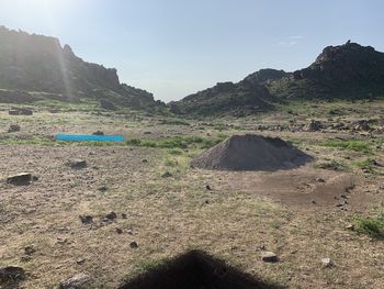
The location of the 2019 trenches. Photograph taken facing south from the House of the Boulders. (Photograph: MB)
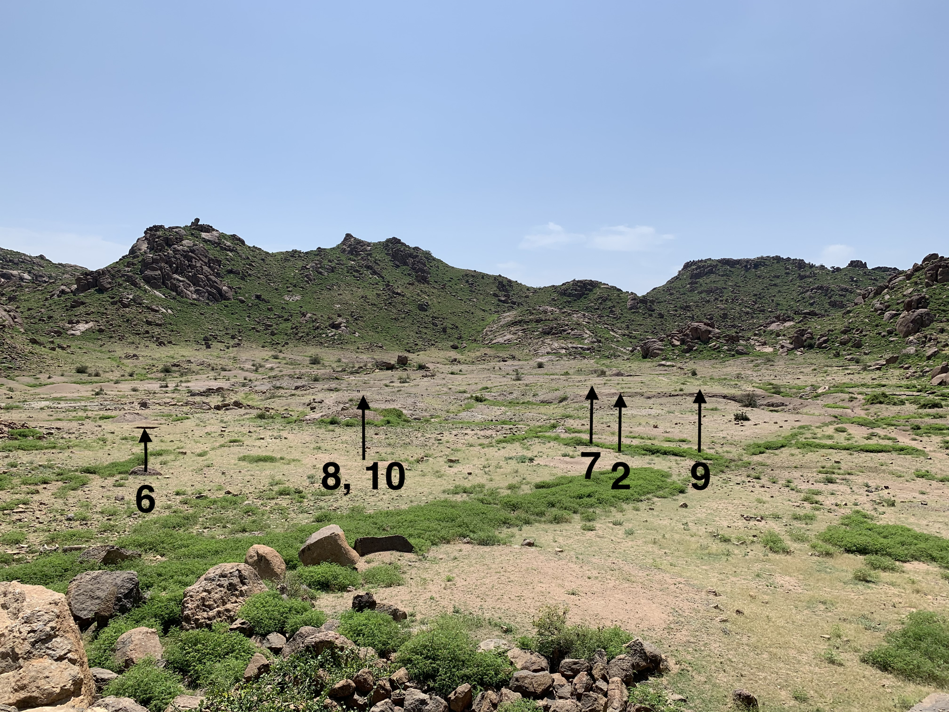
Trench 6 was opened to explore the stratigraphic integrity of the deposits north of where Wellcome stopped his excavations. The north-east sector of Wellcome's expedition is where the highest concentration of and the richest human burials were located. The boundary line where Wellcome stopped his excavations is marked by a low-slung rock wall, and the ground between it and the House of Boulders to the north was occupied by his expedition's camp. This trench is located about 30 m north of the boundary line. Trench 7 was located north-west of Trench 2; here, numerous faunal remains were found exposed on the modern ground surface after the summer rains had stripped off the protective top soil. After collecting the exposed remains, no further work was conducted in Trench 7.
Trench 8 was situated 10 m to the north of last season's Trench 3. A pair of tibiae were seen eroding out of the base of the gully bank, but with the deposit immediately to the west not showing signs of an active slope towards the gully. During the course of the trench's excavation, the remains of three individuals were uncovered. The cranium of a sub-adult was in the north wall and therefore Trench 10 was opened immediately adjacent to the north. Shortly after Trench 8 had been opened, a cranium with mandible and maxilla was observed during a field survey immediately to the south-west of Trench 2. Trench 8 was temporarily closed and Trench 9 opened. The aim was to retrieve skeletal remains before forecasted rains. Cranial and post-cranial remains were excavated using standard methods. Further remains were noted in the immediate vicinity of this trench. These will be examined during the next season.
Trenches 2 and 6 were excavated in 10 cm spits. In Trench 8, four standard 10 cm spits were excavated until the first human skeleton was reached. Neither Trench 2 nor Trench 6 reached natural bedrock or archaeologically sterile horizons. In Trench 2, plastic woven sacks were laid on the lowest level reached and the trench was backfilled, to help protect unexcavated deposits and to facilitate further investigation in future. Excavation of the lowest levels of Trench 2 will resume in Season 3.
Trench 2
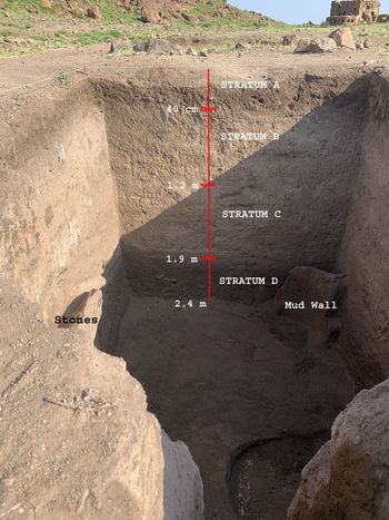
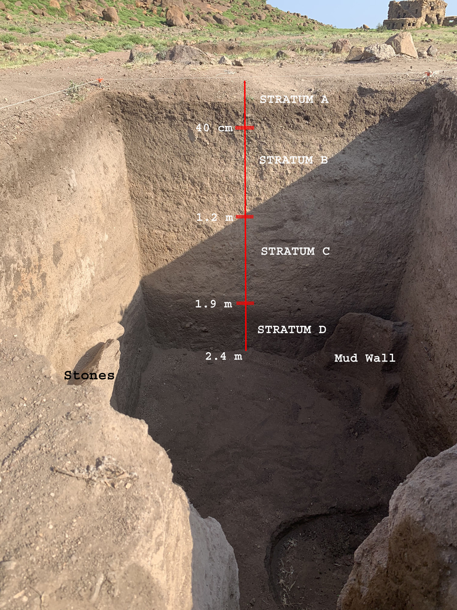
Trench 2 is 2 × 2.5 m. It is situated on a highpoint in the preserved site sediment near an eroded gully section that indicated a considerable depth of stratigraphy, including Mesolithic material at the base of the gully exposure. In 2017, it was excavated to a depth of 1.5 m. In 2019, it was further excavated to a depth of 2.4 m (Fig. 3).
Trench 2, excavated to a depth of 2.4 m. The House of Boulders at the north of the valley is in the top foreground. The two stones in the west wall lie on an ancient floor. (Photograph: MB)
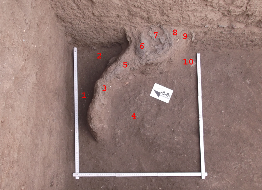
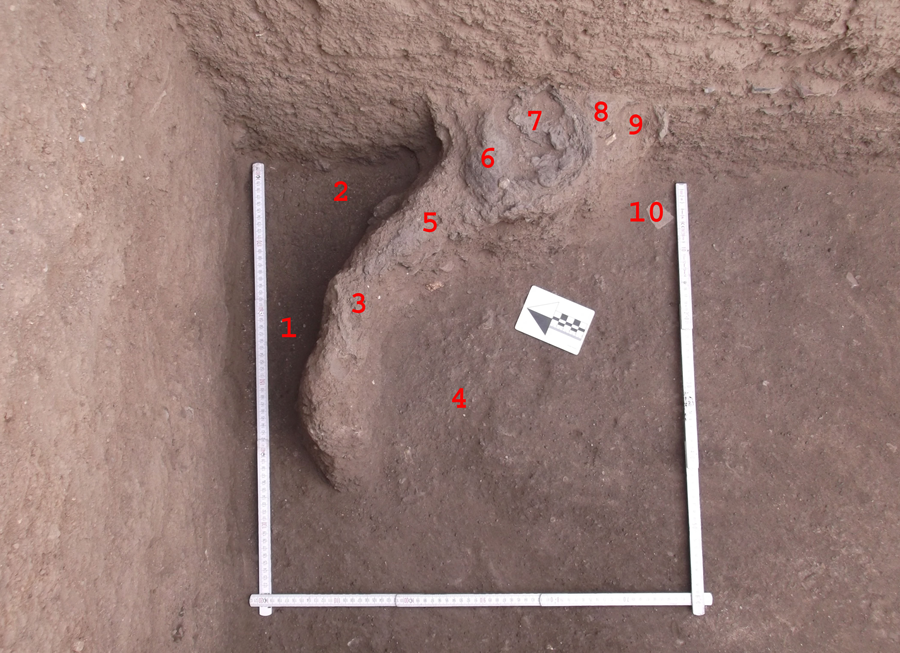
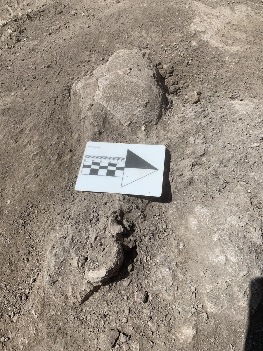
Spit 16 was a 2 cm spit excavated once the trench backfill was removed. It was considered contaminated to avoid the risk of any inadvertent intermixing resulting from the removal of backfill. It overlies Spit 17 and is attributed to Stratum C. The top of a feature was found in the north-east corner of Spit 17. The feature is the remains of a low-lying mud wall with stone inclusions (Fig. 4). Its base is in Spit 19. Similar features were seen on the outskirts of the modern village at the base of the jebel; these are used to demarcate an area outside of the mud brick homes. Spit 19 also included three natrolite (a tectosilicate mineral) beads, pottery sherds, assorted land snail shells, lithics, a grindstone and animal bone. The soil composition was a sandy brown-grey which quickly dried to grey.
The dried mud wall feature. (1) 170 cm, (2) 170 cm, (3) 155 cm, (4) 172 cm, (5) 153 cm, (6) 149 cm, (7) 151 cm, (8) 147 cm, (9) 152 cm, (10) 170 cm are the depth from the feature to the trench level at those points. The ruler is 30 cm. The arrow points to cardinal north. (Photograph: MB)
Spit 18 underlies Spit 17. The soil composition was similar although it was more sandy near the feature. Flecks of charcoal were found near the feature but no charcoal was present in or on it. Also excavated were animal teeth, animal bone, lithics and pottery sherds which varied in thickness. Spit 19, whose soil was grey-brown in colour with charcoal inclusions in the north-west, was overlaid by Spit 18 and overlies spit 20. It is a fill layer around the feature whose base is at the bottom of the spit. The bottom of the spit around the feature appears to be an ancient living floor. The soil composition was similar to the previous spit; however, chalky white inclusions were found in the middle of the uppermost half of the trench in close proximity to the feature. The spit's finds include lithics, charcoal, animal bone and pottery sherds.
Spit 20 was a fill feature. It overlies Spit 22 and underlies spits 19 and 21. This is a new stratum, Stratum D, with the soil more compact, darker brown-grey and with more charcoal and chalky inclusions. The soil is more compact towards the north, where the charcoal inclusions predominate compared to elsewhere. The associated pottery sherds are Mesolithic. Other finds include lithics and animal dung, the latter in the north-west corner.
Spit 21's base is on the same level as the base of spit 19 and overlies Spit 20. This spit is a feature: the above-mentioned mud wall. It is in the north-east corner and protrudes south-westwards from the east section. Part of the top of the right of the small semi-circular wall is a small round depression (6 × 8 cm) in which a rib bone was found. An ‘arm’ extends in a curvature for approximately 50 cm (measured straight). Spit 22 underlies Spit 20. The soil composition is similar to Spit 20, with gravel inclusions. Finds include animal dung, a lip plug in the southern quarter, Mesolithic pottery sherds and lithics.
Spit 23 is unchanged in texture and composition. Finds were sparse in the southern one-eighth of the trench. The soil colour is mid-dark brown grey, as per spits 22 and 20. Finds include Mesolithic pottery sherds, a mud ball, animal bone and an unknown white substance which will be examined for plant and shell remains. Spit 24is a light brown sandy fill which extends from lower Spit 20 in the south-east corner and contains pottery sherds. There is a cut into it (recorded as Spit 25, black-coloured soil). Both are provisionally interpreted as the result of modern seepage with the water reacting to the carbonates present in the soil. Spit 26 is directly beneath Spit 23. Spit 24 goes down in an arc into Spit 26. The soil composition is sandy and is dark grey in colour. Artefacts and other finds are sparse in the southern half of the trench in this spit.
Trench 6
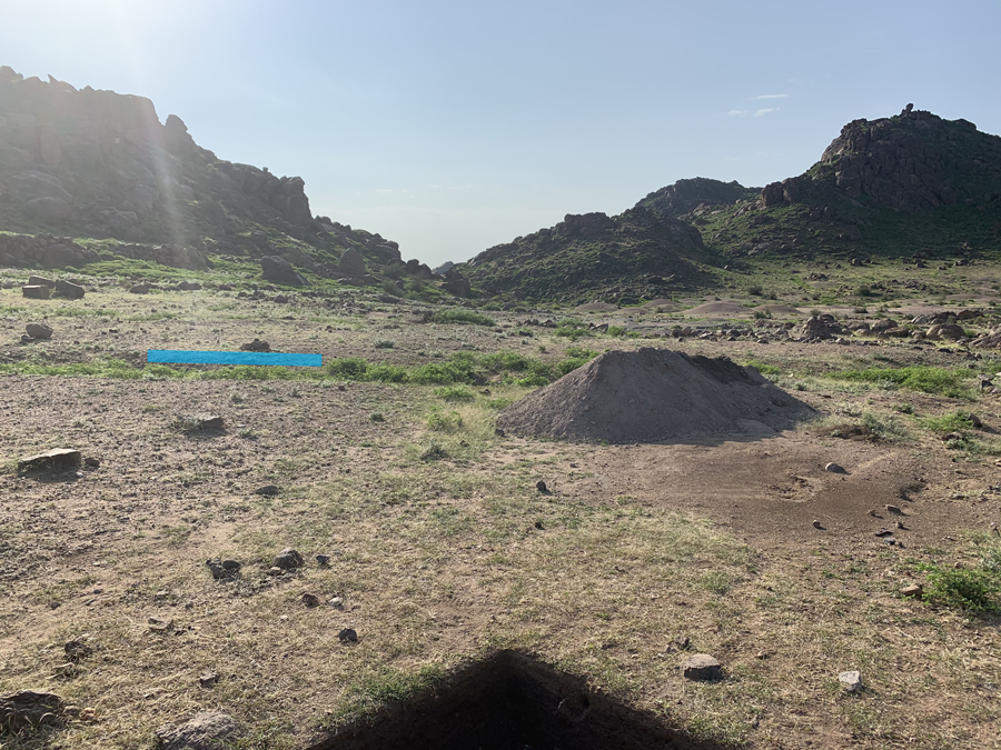
The 2 × 2 m trench was oriented directly cardinal north (Fig. 5). Its co-ordinates are 13° 29′ 8″ N, 33° 19′ 13″ E at an elevation of 480 m absl. After stripping away the ground surface soil, it became apparent that there was no remaining Stratum A in this part of the valley. The colour of the Stratum B soil was a rich dark brown (similar to spits 6 and 7 from Season 1's Trench 1, where it was indicative of organic matter) grading to brown-grey (Stratum C) at a depth of 7 cm into Spit 1. There are no lithics. Fragments of pottery start from a depth of 9 cm and there are small fragments of possibly modern bone in Stratum C. Spit 2 was barren apart from one small lithic, one little animal bone and a few pottery fragments. It is highly likely that spits 1 and 2 were mixed, particularly considering that there was a small modern iron tent peg fragment embedded at 9 cm, a piece of modern glass at 17 cm and an Assemblage 2 thick everted red rim with white inclusions.
Trench 6. Looking south. The blue line marks the extent of Wellcome's excavations. (Photograph: MB)
A lip plug was found in the north-west corner at the top of Spit 3, at a depth of 21 cm. Spit 3 contained three lithics, numerous animal bones (with a concentration in the south-west corner) and a quern partially embedded in the western section wall (62 cm south of the northern section) whose top was at a depth of 21 cm and bottom on the ground surface at 30 cm. Spit 4 contained animal bones, teeth and shell and an increase in the number of pottery sherds. Similar pottery in the central Sudan has been classified as Neolithic (see for example Caneva Reference Caneva1988). However, this terminology does not adequately describe the assemblage. While forming part of Assemblage 2, this particular concentration displays a more diverse range of décor than what is curated at the British Museum and the Petrie Museum and the assemblage retrieved during Season 1. Other finds include a concentration of small animal bones in the south-west and half a large stone bead and a large lip plug to the north. The latter are associated with microliths and were all found at a depth of 35 cm. A large hammerstone (8 × 7×4.5 cm) was located in the south-west. The bottom of the spit was an ancient ground surface, with numerous rocks and hardened soil. The soil was a dark rich brown, differing from the dark brown-grey of Stratum C. This is likely due to organic matter as the subsequent Spit 5's soil composition returned to dark-brown-grey. Spit 5 had grey-coloured soil mixed with stone fragments across the square. There were numerous pottery sherds, small beads, two lip plugs and a Nilotic shell (northern area), in addition to animal bones. There was a grouping of animal bones and teeth in the south-east. There was also a fragment of an upper grinding stone and part of a ring stone. This spit suggests a settlement layer or, minimally, non mortuary-related activities.
Spit 6 has the same soil composition. The pottery continues to display similarities with the central-Sudanese Neolithic assemblages. Shell is found throughout the spit, with many concentrated in the south-east area. Other remains included a small bead, some animal bones and the end of a polished stone axe at a depth of 57 cm. Furthermore, there was a complete mace-head. Mace-heads are common in Neolithic contexts, for example four and three mace-heads were deposited in the graves of males and children respectively, but not in habitation contexts, at R12 (Salvatori Reference Salvatori, Salvatori and Usai2008) and within and outside of graves at Kadero (Cialowicz Reference Cialowicz, Chlodnicki, Kobusiewicz and Kroeper2011). Mace-heads have traditionally been assumed to be symbols of some level of authority, whether transient or permanent. Prior to this, the other known mace-head from Jebel Moya was from Wellcome's excavations, namely burial 1155 (Adult Male, Stratum C). This was recorded as containing a pear-shaped, white granitic mace-head behind the left thigh. In total, 59 mace-heads were recognized from his excavations from both strata B and C, of which the remaining 58 were made from sandstone (available from the plain and not in the granitic valley, Addison Reference Addison1949, 69). Spit 7 has a light red-brown soil that is sandy and loose. The range of stone sizes indicates it was once exposed ground surface. There is a decrease in the number of pottery sherds and faunal remains but there are dispersed shell remains. Spit 8 was similar to 7 in composition.
Trench 7
The trench, located in the western section of the valley, was laid out facing cardinal north. It measured 1.9 × 1.2 m. The area was chosen on the basis of visible animal remains on the modern surface. Further remains were found after the top soil was carefully brushed away. Included in the remains are what look to be two sets of teeth and a possible (shoulder?) joint.
Trenches 8 and 10
Tibiae were observed protruding 60 cm from the edge of the gully, an estimated 80 cm from the relatively flat modern ground surface. The GPS measurements were 520 m absl and co-ordinates of 13° 29′ 4″ N, 33° 19′ 12″ E. A trench measuring 1 × 1 m was laid out oriented westwards. The ground surface layer was scraped away to a depth of 1 cm and the spit recording began immediately below. Spit 1 was immediately into Stratum B. No vestige of Stratum A remained. Stratum B consisted of fine mid-brown soil. Assemblage 3 pottery sherds were found in this stratum. Stratum C was detected from 9 cm down, with soil tending from dark-brown to grey. Pottery sherds found from this depth downwards were Neolithic, with one thick seemingly ‘transitional’ sherd found at 9 cm. Also found in this spit were microliths and ostrich eggshell pieces. Spit 2 had micro-charcoal in the north-west corner from what looked like a small burnt plant. The lithics consist of, among others, scrapers, borers and burins. There is snail shell, ostrich eggshell, a few pottery sherds and small animal bones.
Spit 3 contained disintegrated faunal bones at 55 cm from the north section and 35 cm from the west section, along with two pieces of non-disintegrated bone. These were directly on top of a dark brown soil heavily impregnated with dark grey to black continuous discolouration at a depth of 26 cm, marking the start of Stratum C. There was no charcoal; however, the dark grey to black soil appears to have been plant matter and samples were taken for flotation for depths 27–30 cm. In the west section, at a depth of 26.5 cm and 57 cm from the north section, was a Mesolithic sherd. Other pottery sherds were found at 23 cm but were Neolithic. D animal bone was visible along the south section at a depth of 25–27 cm. There was also a small set of animal teeth at the bottom of the spit. At the base of the spit, 28.5 cm from the north section and 20 cm from the west section, was a concentration of friable large pieces of human bone from the top of the cranium of the Trench 8 Skeleton 1. Ostrich eggshell fragments were found also at the base of the spit within a 30 cm radius of the top of the cranium.
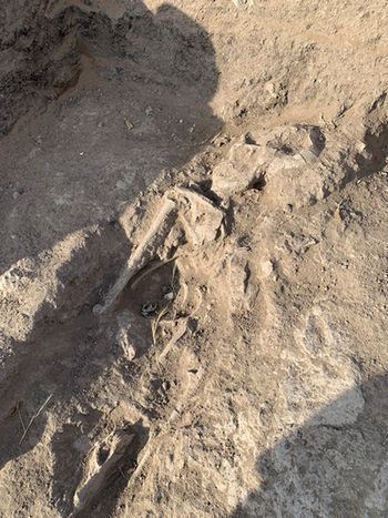
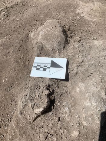
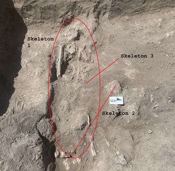
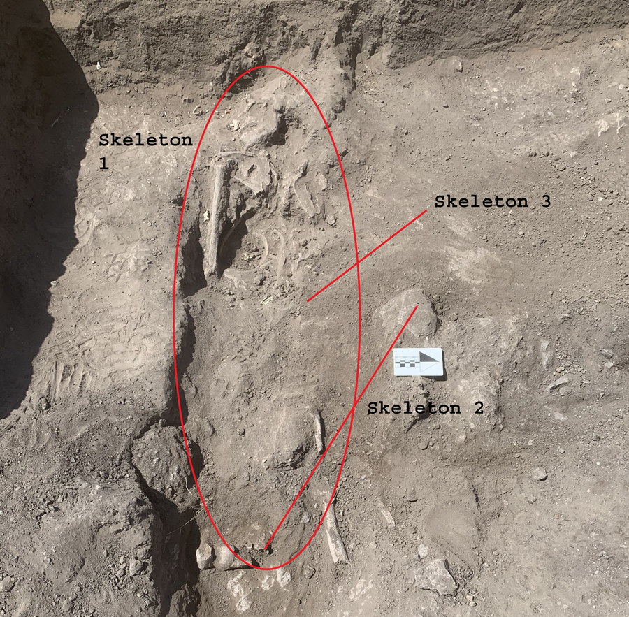
In Spit 4, which had the same soil composition and colour, there was a bed of continuous rock beginning at a depth of 39 cm as measured in the south-west corner; this rock stretched into the western section and continued northwards into what became an adjacent Trench 10. The aforementioned Skeleton 1 cranium and the upper part of its sternum were placed on the rock bed. There were a few lithics, faunal bones, shell and some pottery sherds. Subsequently, we stopped excavating by spits and began slowly excavating down by tracing the human remains (Fig. 6). At 78 cm from the west section along the north section, at a depth of 50 cm, was the first indication of a set of remains from a different individual. Trench 10 was opened immediately to the north of Trench 8. At the same time, excavation efforts also shifted to excavate the tibiae protruding from the gully. It was quickly noted that we were dealing with a total of three individuals. The individual with the protruding tibiae was labelled Skeleton 2 and the individual whose remains stretched from Trench 10 into Trench 8 was Skeleton 3 (Fig. 7). The association between skeletons is illustrated in Fig. 8.
Trench 8, Skeleton 1. It was laid prone with the head to the west, facing south. (Photograph: IVG)
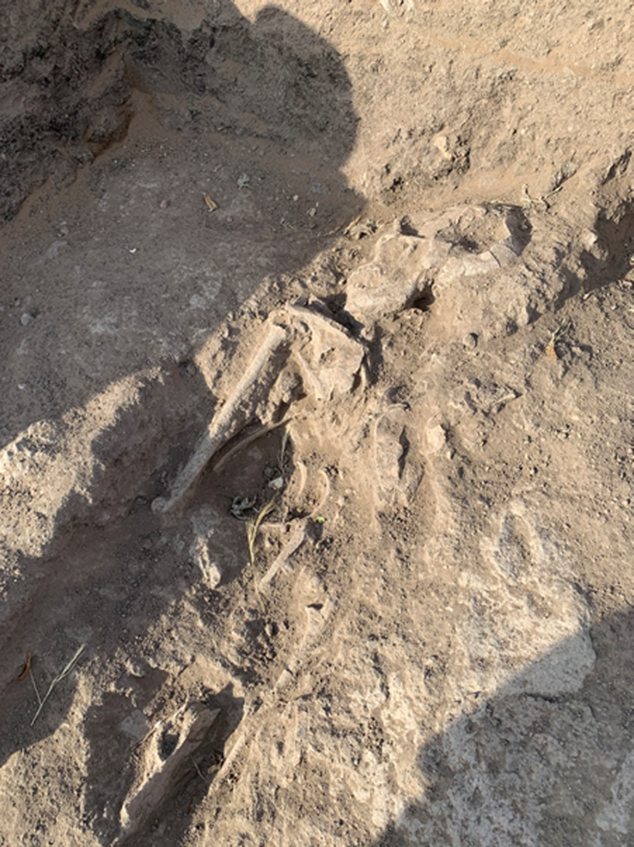
Trench 10, Skeleton 3. The arrow points north. (Photograph: MB)
The association between the skeletons in Trenches 8 and 10. Skeleton 1 is circled, while the alignment of skeletons 2 and 3 are demarcated. (Photograph: MB)
Skeleton 1's teeth, mandible and maxillae were present, with the latter gracile. There was a stone lip plug by its forehead. The face was oriented due south and the body lay prone west to east with the cranium to the west. The post-cranial skeleton was incomplete and preserved only down to the femoral head. Other surviving elements were both clavicles and scapulae, sternum, ribs, both humeri, vertebrae, both radii and ulnae, innominate, left half of the sacrum, patellae and some phalanges. The lower legs and feet were not present. Unfortunately, the remains were highly fragile and prone to post-excavation fragmentation. Maxillary anterior teeth (incisors) showed wear on the lingual aspect, typically observed in dentition used as a tool. The left maxillary canine demonstrated a notch on the distal interproximal aspect, which could have been formed as a result of habitual activity. The individual showed prognathism. Dental wear observed on the occlusal surfaces of the molars was slight and suggestive of the individual's young age of approximately 25–35 years at the time of death.
The medial aspect of the clavicle was completely fused, which is attained by 30 years, corroborating the dental age estimation. The epiphyses of the long bones preserved were completely fused, as expected in an individual of that age. Cranial features were inconclusive in the individual's sex estimation, which is not unusual in Sudanese skeletal remains. The supraorbital ridges and glabellar profile were smooth and not pronounced, and the vertical slope appeared vertical; the features typically associated with a female individual. However, the mandible was robust and the pubic bone showed typical masculine morphology (no subpubic concavity and ventral arch). Metric data was inconclusive in sex estimation: the femoral head diameter (R = 42.2 mm) and bicondylar width (L = 70.4 mm) would normally be indicative of a female individual; however, it is not unusual in the Sudanese populations to have slender male individuals. Overall, the individual was likely a young male: ?M – 25–35 years. There was a broken, large and worn projectile just inside the right elbow over the chest cavity. Two sherds from different pottery vessels were by the left elbow area and embedded, not displaced. As the body was excavated, other lithics, faunal remains, sherds, shell and ostrich eggshell were found. There were animal vertebrae found above and to the left of the burial.
The femurs and tibiae of Skeleton 2 were robust. They were crossed over each other at their join with the femur, angled right to left as seen when facing the trench from the gully, with these tibiae being the tibiae protruding from gully edge. The skeleton was incomplete (<10%), poorly preserved and fragmented, therefore the collection of metric data and macroscopic assessment of the remains was extremely limited. Overall, only a fragment of the occipital bone and mandible were present, and the post-cranial skeleton consisted of the fragmentarily preserved left scapula, humeral shafts, radial shaft, the left proximal femur, proximal tibiae and fragments of the fibular shafts. Skeleton 2's femoral head diameter (L = 39.7 mm) is suggestive of a female individual (<45 mm = F). Its incomplete mandible showed permanent dentition. Mandibular molars showed moderate to severe occlusal wear; several teeth were lost ante-mortem, including RM2, RP1, RI2-1 and LM3. A single and extensive caries lesion was noted on the distal interproximal aspect of LM2, affecting the crown and extending below the cemento-enamel junction. No calculus deposits were noted. Dental wear observed on the occlusal surfaces of the left-side molars was advanced, suggesting the individual was likely over 35 years of age at the time of death. The mandible showed features typical of a female individual, including smooth anterior aspect and obtuse mandibular angle. The individual was likely an adult female: ?F – 35+ years.
Skeleton 3 was present to the right of Skeleton 1. There were indications of post-depositional disturbance: the bones were light and some, apart from the cranium, had shifted leftwards to end up over the prone right side of Skeleton 1. The remains consist of the incomplete frontal bone, incomplete parietal bone, superior aspect of the occipital bone, medial part of the left clavicle, five rib fragments, a vertebral body, and a fragment of acetabulum, which could belong to another individual. The frontal sinuses were not formed yet, so the sub-adult was most likely around 6+ years at the time of death. Ostrich eggshell, lithics and pottery sherds were in association, and a microlithic arrowhead was nearby in direct association. The pottery sherds found with all three individuals were all Neolithic and bear similarities to the Neolithic pottery from Trench 6.
Trench 9
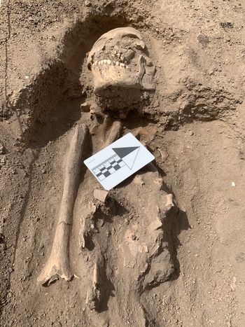
The GPS measurements were 13° 29′ 2″ N, 33° 19′ 9″ E and 520 m absl. A potentially rich area of human skeletal remains was noted during a survey to the south-west of Trench 2. The summer rains had exposed part of the mandible above the ground within a slope. The square was an estimated 30–35 m south-west of Trench 2. The body was deposited in Stratum C. The body was oriented north-west (334°) (Fig. 9). The head was turned to the body's right, facing south-west. The teeth were in excellent condition. The cranium was present but fragmented, held together by the pressure of the surrounding and infilled soil. The mandible is robust but also fragile. The post-cranial skeleton included fragmentarily preserved right scapula and clavicle, shaft of the right humerus, fragmented cervical vertebrae and ribs, one cuneiform and proximal hand phalanx. The remainder of the vertebrae and the lower half of the body were eroded away as the slope formed and was eroded back.
Trench 9, Skeleton 1. Supine. Head oriented north-west. The arrow points to cardinal north. (Photograph: MB)
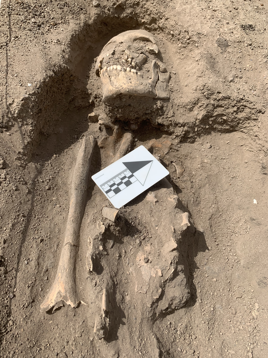
The individual's permanent teeth were well preserved, allowing for dental age estimation to be made. Dental wear observed on the occlusal surfaces of the molars was advanced but likely a result of a habitual use of the teeth or very coarse diet consumed by the individual. The extensive enamel chipping observed on the molars would support that observation. Non-masticatory use of the teeth would advance dental wear, creating a pattern observed in older individuals. The individual was likely over 30 years of age at the time of death. Cranial sutures were largely open or in very early stages of obliterations, suggesting a young-middle adult. Cranial features were robust and pronounced, including the supraorbital and temporal ridges, pronounced glabella profile, and robust mandible with near-vertical ramus. The mastoid process was also very robust and large (L = 36 mm; R = 34.2 mm). Overall, the individual was a male: ?M – 30–45 years.
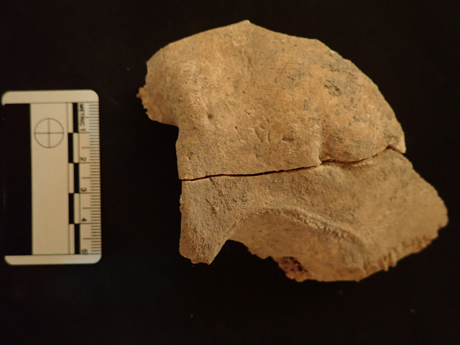
This individual has an interesting pathology. Two small-size depressions were noted on the frontal bone and above the orbits. The depression observed on the left frontal bone could be a healed trauma from a projectile (round and well healed) (Fig. 10). During excavation, a small microblade was found by the right eye socket and a second lithic on the sternum. Other finds include charcoal on the top of the sternum and a second charcoal patch where the left hand (not preserved) would have been. Ostrich eggshell was directly under and abutting the chin, as well as in situ 20 cm from the base of the mandible on top of the sternum. A faunal bone was found by the cranium.
Trench 9. The left frontal bone with a marked temporal ridge and a circular depression (possible trauma). (Photograph: IKO)

The changing face of Sudanese archaeology: Heritage and community engagement
The current project actively employs and trains a number of graduate students. Some are now core members of the team. With their assistance, we identified lacunae in training and fieldwork experience. This is in stark contrast with Wellcome's complex camp system. While Wellcome employed numerous Sudanese, some of whom came from Jebel Moya, the vast majority of excavation oversight work was in the hands of Egyptians. The lists of expedition members record all the European/non-African members. For the large part, the Sudanese remain anonymous, for example in Scrapbook Season 1912–13 (Wellcome Archives, HSW/AR/JEB1) the list of expedition members references ‘native cook’. The archives make frequent mention of Wellcome's views on the inhabitants of Jebel Moya. In a letter dated Sagadi, 16th January 1913 (Wellcome Archives, WT/A/2/3/1: Box 1) we encounter the names Faki Suliman Mohamed (grandson of the ruling Mek of Sagadi), El Hussein Adam (ex sheikh of Sagadi), el Mahdi Higazi (nephew of the sheikh of Gebel Doude) and El Besheir Higazi (former sheikh of Gebel Doude). They express interest in his Jebel Moya work and ask him to do the same at Sagadi. Wellcome's response is not known. The other name, El Sheikh Maki Aby (sic) Heraz, appears in the infamous sermon. Some Egyptian names appear in an agreement between Wellcome and Ahmed Sabir el Dongolawi, captain of the dabbah that took Wellcome along the Nile and into Sudan. There is also a list of the crew members. The same archive has a typed list of Egyptian names and wages, a small fraction of the men hired by Wellcome to excavate at Jebel Moya and a hastily scribbled list of names labelled ‘engineering team 1912’. Wellcome had also employed a large number of men to help the Condominium Government with irrigation projects. Wellcome's voluminous correspondence mentions the employment of thousands of ‘natives’, but they remain pointedly nameless. They are treated as a single anonymous entity, and this also applied to experienced Egyptian excavators.
And yet, the ra'is (foreman) in Egypt was an important figure in charge of organizing a large number of people. Both Flinders Petrie and John Garstang acknowledged the contribution of their foremen, even if in oblique ways (see for example Riggs Reference Riggs2017; Thornton Reference Thornton2020). The silence of the Jebel Moya record was very disquieting. From the outset, it was clear that the current project would have to explicitly engage with the local community and the Sudanese archaeological community. This remains an ongoing and evolving process. The inclusion of Sudanese communities in archaeological projects has evolved over the years, but full-scale involvement remains in its infancy. Examples of good practice include the Mograt Island Collaborative Project, the UCL Qatar Meroe Project and the UMMA Archaeological Project in Old Dongola.
One of the more dangerous assumptions regarding Sudanese archaeology is the view that the Sudanese are not interested in pre-Islamic heritage. This reductive view is in sore need of decolonization. As Näser (Reference Näser2019) argues, archaeologists should do more to redress this. She argues that community engagement needs to go beyond creating economic opportunities and, as outlined in her study, people are very much engaged with pre-Islamic heritage but they do so on their own terms. Work by Humphris and Bradshaw (Reference Humphris and Bradshaw2017) demonstrates that communities see the benefits of archaeology in terms of historical information and that this does not need to be separate from any economic benefits (see also Bradshaw Reference Bradshaw2018). Ultimately, as Näser (Reference Näser2019) points out, it is up to archaeologists to provide open-ended collaboration rooted in the present.
Bearing in mind the legacy of Henry Wellcome, the present mission launched a programme that places both the inhabitants of Jebel Moya and Sudanese archaeologists at the core of its ethos. In the first instance, it was decided that all team members would appear as authors in field reports, especially since everyone was asked to contribute to the trench notebooks. While the directors oversaw the project and directed the fieldwork, the process always involved discussion with all excavators and everyone gained experience of being a trench supervisor. Second, it was decided to implement an outreach project led by Isabelle Vella Gregory (IVG) in partnership with Rayan Abdallah. We have adopted a broad approach to the outreach work. The Jebel Moya community is actively invited to participate in various ways. The community appreciates the economic benefits (in terms of fair wages for food, labour and shelter), but there is also widespread appreciation for being invited to actively join the project in other ways. As the seasons progressed, more people came to view the excavations and ask questions. Thus far, there has been a reluctance for participation in fieldwork activities, but this is being explored for future seasons. We also adopted an open-door policy to post-excavation, resulting in a constant stream of people (all ages and sexes) observing, asking questions, offering interpretations and handling objects.
The project also has a blog (https://thejebelmoyaproject.wordpress.com/) and a Facebook page (https://www.facebook.com/JebelMoya). The blog is published in both Arabic and English, with contributions from team members. Posts in Arabic have attracted considerable attention, particularly among the residents of Jebel Moya. While the blog and Facebook page are an invaluable resource for archaeologists and broader interested audiences, the outreach programme is also for the benefit of the Jebel Moya community. The long-term aim is to have full involvement from the community, but this endeavour presents many challenges. First, access to the Internet (and thus the blog) is limited. The majority of residents do not own computers or smartphones; however, posts are shared by those who do own this equipment. Second, the Jebel Moya community remembers the Wellcome excavations in specific ways. They remember the tents, the relatives who worked there in some capacity, and stories, often embellished, about Henry Wellcome. At no point was the village of Jebel Moya fully engaged with excavations other than to provide labour. It is worth noting that Wellcome's camp included Egyptian excavators and a large number of people from many areas of the Sudan, that is, not part of the local community. As such, this project aims to redress the balance and place the community at the heart of our work.
Key to this project was establishing trust and good relations. This endeavour was made easier by the presence of Sudanese archaeologists. Their contribution goes beyond fieldwork and they have played a vital role in our broader collaborative project. Ammar Abdalla and Osman Alawad played key roles in responding to questions during excavation. There was great interest in the past environment. In the process, IVG identified the need to improve her command of Arabic, particularly the dialect spoken in the area. In return, a large number of school girls aged 7–16 asked for help with English lessons. IVG observed that group activities, particularly ones in which information was transmitted, formed a core part of life in modern Jebel Moya. Consequently, English lessons were used as a medium to open a dialogue about our project, opportunities for further education and a broader exchange of information. IVG organized two drawing sessions for children, male and female. The response was overwhelmingly positive. Children drew pictures of the Jebel and pottery finds. The pictures are now part of the Jebel Moya archive.
Many women at Jebel Moya were kind enough to open their doors to IVG and invite her for coffee. This invitation is part of a system of bonding and friendship within households. It is, essentially, an invitation to a household's inner sanctum. The preparation of coffee is part of the process of exchanging relations and information. During this ritual, IVG, Abdallah and Albadwi passed around a number of artefacts and answered questions. In the evenings after excavation, prayers and dinner, it is customary for men and older boys to congregate in one of the village's open piazzas. IVG was often invited to join. This was a time for general chat, but many villagers asked questions about the day's work, specific finds and the general purpose of our work. Some people expressed surprise at interest in what is often viewed as a marginal environment. The villagers responded best to a narrative technique, which talked about the history of the valley in the years before the birth of the Prophet. There was special interest in faunal remains, particularly the finding of waterbuck and gazelle, especially as ‘moya’ is Arabic for ‘water’ and a common refrain heard was ‘Where is the water?’ These stories were then shared with the wider community. IVG observed men and older boys repeating these stories to women, generally while women were busy with numerous household tasks. Women would then seek out IVG and ask more questions. On evenings when we were able to observe the Milky Way, the villagers recounted how the Milky Way is ancient and would have served as ‘light’ for the ancient people on the mountain.
During the middle of the excavation, Fath el Rahman, one of the community leaders and a keen supporter of the project since its inception, shared with us a teapot from Wellcome's expedition. He generously dedicated time to identify people and places from the Wellcome photographic archive. He explained that his great-grandfather worked in the camp kitchens. It is worth remembering that Wellcome had always intended to return to the Sudan after the First World War. This was not to be and he died in 1936. By 1938, the camp was shut down and Major Uribe, the camp commandant, left Sudan. We do not know what happened to the many things that formed part of the vast camp. Some were shipped back to England, but others appear to have found a new life in Sudan. Fath's great-grandfather kept the teapot as a memento. It has been stored safely for all these years, and it is not used to make tea. Rather it is a treasured memory of days gone by and an excellent conduit for reminiscing and telling stories.
The outreach programme is a continuous and dynamic process. Future aims include strengthening relations with the community so as to better identify its needs and wants. In particular, we hope to have more involvement from women. It is acknowledged that their days are long and full of many complex tasks. However, as trust is built up and more invitations for coffee were received, it was possible to meet more women and broaden the audience. It is hoped that resources can be found to offer basic smartphones to key members of the community. This will enable the villagers to access information more quickly; currently, posts are shared by a Jebel Moya teacher who works in Sennar but visits the village regularly. Outside of Jebel Moya, the team continues to work with Sudanese colleagues and offer training to students. More broadly, there is a continued investment in the blog and the sharing of resources.
Discussion and conclusion
This project has highlighted the lack of research on the inhabitants of the Gezira plain. One puzzling refrain from the villagers was that they lacked history. These ideas appear to be rooted in more recent colonial history, particularly with the start of the Gezira Scheme. Before the Condominium Government, European commentators sought to root Sudanese culture into past civilizations, notably the Funj kingdom. This view appears to have filtered through the present times, with Sennar identified as the realm of the Funj and Jebel Moya as a peripheral wasteland. The idea of a wasteland is perhaps part of a broader policy by the Condominium Government that recast the Gezira plain as a wasteland (Clarkson Reference Clarkson2005), with some exceptions to account for the Funj. This enabled the Condominium Government to carry out its ambitious large-scale scheme. In reality, the area had been inhabited by a number of different groups even in antiquity (see for example Randell Reference Randell and Lebon1963, Reference Randell1966). Furthermore, as Hassoun (Reference Hassoun1952) notes, there is a migrant tradition involving ‘western’ migrants coming from west of Kordofan and moving eastwards and people coming in from east Africa. The timeline for this remains uncertain but, as Hassoun (Reference Hassoun1952) notes, the migrant tradition is part of the consciousness of numerous groups across the Gezira. This part of Sudan's history remains understudied. There are two points of relevance to Jebel Moya. First, an old migrant tradition has been detected locally. This requires further investigation by historians and anthropologists. Second, the Gezira Scheme, which brought in another influx of migrants, did not directly benefit Jebel Moya. While some inhabitants appear to have been engaged in labour, the village received no discernible economic benefits, further leading to a sense of marginalization. These themes will be explored in more detail in the coming seasons, utilizing Näser's (Reference Näser2019) approach of open-ended collaborative practice rooted in the present.
The 2019 season focused on the Neolithic and Mesolithic occupations by virtue of the initially unexpectedly thin Stratum B in the north-east sector of the valley. The southern Gezira environment became habitable during the second half of the sixth millennium BC as the 500 mm ishoyet, which increased the northern range of the biting Tabanidae fly, retreated southwards (Adamson et al. Reference Adamson, Gillespie, Williams, Williams and Adamson1982). Previously, large swamps were much reduced in size (Wickens Reference Wickens, Williams and Adamson1982, 43). Whether domesticated animals were present during the first occupations is as yet unknown. Animal bones were observed in the gully adjacent to Trench 2 from Stratum D, and this is one of the unresolved questions which will be answered by the continued excavation of Trench 2. The Late Mesolithic pottery from Trench 2 is currently being analysed for publication. The preliminary examinations reinforce Brass et al.'s (Reference Brass, Adam and Wellings2018c, Table 5) previous analysis of the Late Mesolithic pottery curated at the National Museum (Khartoum), namely that burnishing and slipping are not present, evenly and unevenly serrated combs were used to produce décor, and that there is a wide variety of motor actions (e.g. comb-stamped lines with packed zigzag dots). None of these motor actions has previously been recognized, with the exception of Caneva's dotted wavy line from the British Museum collection.
The next securely dated occupation currently spans the early to late third millennium BC (Brass et al., Reference Brass, Fuller, Macdonald, Stevens, Adam, Kozieradzka-Ogunmakin, Abdallah, Alawad, Abdalla, Vella Gregory, Wellings, Hassan and Abdelrahman2019). The first identified domestic animals and the domesticated sorghum remains are from this period. More information on the ecology and food remains will be available once the material retrieved this season from strata C and D is examined. The condition of the four human skeletons is suggestive of attribution to this period, contemporary with 2017's Trench 3's human skeleton (3880 ± 40 bp, 2470–2210 BC. GdA-5760). Samples from three of the skeletons have been sent off for radiocarbon dating, and aDNA, carbon and oxygen isotope analysis. The pottery sherds associated with the human skeletons and from the majority of the spits from Trench 6 were Neolithic. The sherds show variability seen neither in the British and Petrie Museum collections, nor from the 2017 season. Like the Mesolithic pottery, they are currently being studied and one of the aims is to determine the validity of superficial resemblances to Neolithic sherd décor from central Sudan. Should the AMS results return expected middle–late third millennium BC dates, they will confirm an emerging hypothesis that burial activity started much earlier than the late first millennium BC model originally proposed by Brass (Reference Brass2016). One major challenge will be to reconstruct the distribution and nature of these multi-phase burials.
The next phase of the project involves a detailed analysis of the pottery. Plans for a third season of fieldwork are currently being drawn. We will continue the excavation of Trench 2 to determine when the first occupation of the valley occurred. We have also identified two locations rich in occupational materials and human and animal remains. These will further enhance our knowledge of Neolithic burial practices and the environmental conditions of all the occupational phases.
Acknowledgements
We thank the Society for Libyan Studies for its grant and the people of Jebel Moya on whose land we work with their co-operation. We are also grateful to the National Corporation of Antiquities and Museums (NCAM) for their continued support. We are grateful to the anonymous reviewers for the valuable feedback.