




Introduction
Research on colonial cities has long been dominated by the “dual city narrative,” a paradigm that reduces complex urban spaces to a binary opposition between the colonizers’ “White Town” and the colonized’s “Black Town.” While this model offers heuristic value and provides a potent analytical starting point for understanding imperial spatial politics, its overly generalized limitations have become increasingly apparent. With the deepening of historical studies, scholars widely recognize that such rigid segregation often reflected more of a political aspiration and administrative ideal for colonial managers than an accurate depiction of the socially hybrid reality of colonial cities.Footnote 1 To discern the actual operational logic of colonial urban space, it is imperative to move beyond simplistic binary models and instead focus on the fluidity, ambiguity, and inherent complexity exhibited by segregative boundaries in practice.Footnote 2
This complexity is rooted in the pluralistic nature of colonial societies themselves. First, colonial societies were often multi-ethnic and multicultural “melting pots”, where the identities of segregated populations involved intertwined dimensions of race, occupation, religion, and class. Furthermore, extensive processes of cultural amalgamation, adaptation, and localization continuously shaped new groups and hybrid identities,Footnote 3 making it practically difficult for colonial governments to enforce strict and effective spatial segregation upon groups with singular, pure identity markers. Second, traditional research often underestimated the agency of the colonized. Their daily interactions with colonizers concerning employment, commercial cooperation, land transactions, and even intermarriage,Footnote 4 alongside various forms of resistance, evasion, and refusal in the face of segregation policies,Footnote 5 inevitably permeated, eroded, and sometimes partially breached physical boundaries of segregation.
However, while such a revised narrative successfully dilutes the binary opposition in terms of physical space, it often remains trapped within the core colonizer-colonized binary framework when analysing actors—that is, it still overlooks groups and actors that objectively existed during the colonial process but could not be easily categorized into these two main camps. This theoretical blind spot becomes evident when we turn to the seventeenth-century VOC colonial town of Zeelandia in Taiwan. In this case, the Chinese immigrants who formed the core of the town’s citizenry occupied a highly peculiar position: they were neither European colonizers nor could they be classified as the typically conceived colonized—the indigenous peoples of the island.
More crucially, and often overlooked, the economic lifelines, social networks, and political allegiances of these Chinese were fundamentally tied to a powerful “External Actor”—the pirate-merchant confederations, particularly the later consolidated Zheng family group, based along China’s southeastern coast. Although this actor did not establish a permanent governing body on Taiwan, it profoundly influenced the rise and fall, social structure, and spatial form of Zeelandia through its agents—the Chinese merchants acting as an “Intervening Group.” From the initial Dutch fears of pirate attacks, through a mid-period honeymoon of cooperation with Zheng Zhilong 鄭芝龍, to the final military confrontation with Zheng Chenggong (Koxinga 國姓爺), this external maritime power loomed over Zeelandia like a spectre, constantly challenging and constraining Dutch colonial authority and rendering their spatial strategies fraught with contradiction and vacillation.
Scholarly debate on how to position the Chinese immigrants in Dutch-era Taiwan has been contentious. The most influential view, proposed by Tonio Andrade, uses the concepts of “co-colonization” and “the Sino-Dutch Hybrid Colony”Footnote 6 to characterize the colonial model in Taiwan, thereby placing Chinese settlers, to some extent, within the category of colonizers. His arguments rest on two main points: First, historical records indicate that “in the first year of Chongzhen 崇禎元年, Zheng Zhilong 鄭芝龍 accepted recruitment by the Ming dynasty… . He recruited tens of thousands of victims along the coast to Taiwan to cultivate the land,”Footnote 7 suggesting that large-scale Chinese migration to Taiwan was actively promoted by Chinese authorities and local elites. Second, he argues that, “since would-be Chinese colonists lacked a state to support their migration and open up overseas lands, they were willing to cooperate with the Dutch, who, for their part, lacked colonists,”Footnote 8 through resource complementarity and cooperation in Taiwan, both sides achieved colonial development and exploitation, creating a win-win situation.
Another perspective, however, challenges this view by focusing instead on the colonized status of the Chinese immigrants. Drawing on a detailed analysis of economic data like tax books and trade accounts, economic historian Hui-wen Koo 古慧雯 argues that the Chinese who migrated to Taiwan were predominantly from the subaltern classes of Southern Fujian 閩南, whose main objective was mere subsistence and small-scale profit. This reality highlights a sharp disparity with the vast wealth that the VOC extracted from them through fiscal policies and commercial monopolies, leading to the conclusion that these Chinese were not co-colonizers but a colonized group facing systemic exploitation and oppression.Footnote 9 Furthermore, from a political standpoint, scholars both opposing and advocating for China’s historical sovereignty over Taiwan have objected to the “co-colonization” thesis. Jacobs argues that the concept inadvertently implies Taiwan became part of China under Zheng’s rule, which misrepresents seventeenth-century historical realities,Footnote 10 while scholars like Bi-de Liu 劉彼德 and Jun-ling Huang 黃俊凌 emphasize the absolute dominance of the Dutch colonizers and their sovereignty infringement and economic exploitation of the Chinese in Taiwan.Footnote 11
This positioning dilemma reveals the need for a more precise conceptual framework that transcends the binary opposition. Drawing on political scientist Emerson’s classic definition, colonialism is “the establishment and maintenance, for an extended time, of rule over an alien people that is separate from and subordinate to the ruling power.”Footnote 12 Historian Ferro further notes that “colonization is the policy by which a country seeks or acquires other lands and their indigenous populations through warfare or other means.”Footnote 13 This policy is characterized by the colonizers’ acquisition of substantial privileges, the plundering of indigenous peoples’ properties, or the establishment of legal and systemic frameworks that disadvantage the indigenous populations.Footnote 14 From this, we can outline three main elements of colonialism: first, military conquest of land; second, establishment of unequal ruling privileges over an alien people, and third, economic exploitation and resource extraction from the alien people. By this standard, the Chinese migrants from the southeastern coast of China, despite purchasing and developing land in Taiwan under colonial rule, never participated in the military conquest of the island, nor did they establish their own ruling authority. In fact, they faced political marginalization and various forms of economic exploitation by the colonial regime at different times. Therefore, it is difficult to categorize them as colonizers. However, unlike the indigenous inhabitants of Taiwan, they did not suffer from large-scale land dispossession by the colonizers. Moreover, some upper-class Chinese even engaged indirectly in the economic exploitation of the colonized indigenous population through cooperation with the colonial authorities, thereby becoming, to some extent, accomplices of the colonizers. Consequently, they cannot be simply understood as purely colonized subjects either.
Such a group—described as “those imported from a third territory in the colonial system”—was aptly defined by Horvath as the “intervening group,” distinguishing it from both “colonial inhabitants” and “indigenous inhabitants.”Footnote 15 This paper adopts and further develops this concept, specifying it within the context of Zeelandia as the “Chinese intervening group,” so as to highlight its indispensable role as a bridge and buffer between the Dutch colonizers and the “external actors” from China’s coastal regions. Additionally, it should be explicitly clarified that the term external actors, as proposed in this study, refers to those entities that, while not physically present within the territorial boundaries of the colony, were able to exert sustained structural pressure through military, economic, or political networks, thereby profoundly shaping both the internal social relations of the colony and its external spatial configuration.
Building upon this, using the spatial segregation in colonial Zeelandia as the central focus, this paper aims to break through the traditional colonial binary narrative and reveal how the external actor profoundly influenced and shaped the colonial town’s spatial order and social power relations through the key channel of the Chinese intervening group. The analytical framework consists of three parts: First, an in-depth analysis of the special economic status and social composition of the Chinese intervening group in Zeelandia, and their paradoxical symbiotic relationship with the Dutch colonizers, marked by both dependence and suspicion. Second, a detailed diachronic examination of the thirty-eight years (1624–62) of Dutch colonial history in Taiwan, dynamically presenting how Zeelandia’s spatial segregation underwent subtle yet profound changes in response to shifts in the external political situation, revealing the inherent fluidity and vulnerability of the colonial spatial order. Finally, by introducing a comparative perspective, placing Zeelandia within the spectrum of VOC Asian colonial cities alongside Malacca and Pulicat, this paper argues that the magnitude and nature of the structural pressure exerted by the external actors were key factors leading to decisive differences in spatial segregation patterns among different colonial settlements.
Dependence and Suspicion: The Paradoxical Symbiosis between the Chinese Intervening Group and the VOC
The uniqueness of Zeelandia stemmed fundamentally from the VOC’s high dependence on a cross-strait trade network constructed by Chinese merchants for its colonial revenues in Taiwan. Against the backdrop of the Ming Dynasty’s maritime prohibition policies and the VOC’s repeated failures to establish direct trade posts in Macau and the Penghu Islands along the China coast, Taiwan, located less than 150 kilometres across the strait, logically became the Company’s ideal colonial settlement for attracting Chinese merchants and obtaining Chinese goods like silk and porcelain.Footnote 16 As scholars Hauptman and Knapp emphasize, “Throughout the Dutch tenure on Formosa, the greatest potential source of profit was China”; in comparison, “the commercial exploitation of deer caught by aborigines or crops produced by Chinese agriculturalists helped fill a void but always remained subsidiary.”Footnote 17 The Sino-Japanese-Taiwan triangular trade, facilitated by Chinese merchant ships, particularly the trade of shipping Chinese raw silk to Japan for silver, generated substantial profits for VOC in Taiwan. Statistics show that “of the United East India Company’s twenty factories throughout the world, the Tayouan 大員 factory was the second most profitable, after those in Hirado (1609–1641) and Deshima (1641–1855) in Japan.”Footnote 18
The indispensable role of the Chinese merchant group in the colonial economy is also discernible through shifts in the financial and military support allocated by the Company’s Asian headquarter to the Taiwan settlement. Upon their arrival in 1624, stable cooperation with major Chinese merchant groups had not yet been established, and trade with China was nearly stagnant. Consequently, the Asian headquarter in Batavia showed little interest and was reluctant to provide sufficient support, leaving the Taiwan governor initially unable to conquer inland indigenous tribes or build proper fortifications.Footnote 19 It was only after the mid-1630s, when Zheng Zhilong’s 鄭芝龍 group unified coastal forces and reached a trade agreement with the Company, leading to large-scale Chinese trade in Taiwan, that the Taiwan governor received military reinforcements from Batavia, enabling the conquest of indigenous peoples and the establishment of Dutch rule over the southwestern plains of Taiwan.Footnote 20
Taiwan’s strategic proximity to the China coast and its established role as a Sino-Japanese entrepôt resulted in the Chinese constituting an overwhelmingly large proportion of Zeelandia’s citizenry. Dutch sinologist Leonard Blussé described Batavia as a “Chinese town” due to its predominantly Chinese population and heavy reliance on Chinese labourers and merchants for daily operations.Footnote 21 In fact, the proportion of Chinese within Zeelandia’s total urban population was far higher than in Batavia. Statistics from 1632 show Batavia had 4,554 free citizens and a total population of 8,060 (including Company employees, garrison, citizens, and slaves), with 2,424 Chinese, constituting about 53 per cent of the citizenry and 30 per cent of the total population.Footnote 22 In contrast, contemporary Zeelandia, though lacking precise census data, reportedly had about 1,000 Chinese residents by 1639.Footnote 23 Furthermore, records indicate that around 1650, the total permanent population of Fort Zeelandia and the town was about 2,000, with a garrison of 1,200, implying a civilian population of around 1,000.Footnote 24 Based on the above considerations, it can be reasonably inferred that the urban population of Zeelandia was composed almost entirely of Chinese residents. A more compelling evidence comes from the mid-1640s cadastral records of Zeelandia: among the 320 urban plots with identifiable owners, aside from a small number of properties owned by the Company, its employees, and Dutch or European free burghers, the remaining 258 plots were all held by Chinese.Footnote 25 In other words, approximately 80 per cent of the urban property was Chinese owned. Therefore, whether viewed through the lens of demographic composition or land ownership, Zeelandia was, by any measure, a veritable “Chinese town.”
These Chinese residents of Zeelandia, defined here as the Chinese intervening group, were not isolated, discrete individual migrants. They maintained highly close connections with powerful external actors along China’s southeastern coast—the pirate confederations, especially the later organized Zheng family group. First, from a concrete political-economic perspective, Chinese merchants have historically engaged in subordinate relationships with these pirate groups. In the early seventeenth century, to circumvent the Ming Dynasty’s prohibition on trade with Japan, Chinese merchants began to travel to Taiwan to engage in commerce with Japanese merchants,Footnote 26 paying protection fees to coastal pirate groups to ensure their safety during their voyages.Footnote 27 By 1637, Zheng Zhilong 鄭芝龍, a figure embodying both merchant and pirate characteristics, had come to dominate the Fujian trading network, exerting complete control over the maritime trading activities of Chinese merchants.Footnote 28 Following the capture of Nanjing by the Qing army in 1643, the ensuing political turmoil in Southeast China’s coastal regions further entrenched the subordination of Chinese merchants to the Zheng family. Zheng Zhilong’s son, Zheng Chenggong (Koxinga 國姓爺), established a fifteen-year rule over the region, implementing a formal system of taxation and regulation that facilitated trade expansion. He also utilized his maritime military capabilities to safeguard junks, thereby extracting protection fees from coastal merchants and warlords.Footnote 29 Secondly, from a socio-cultural perspective, historian Fu Yiling’s 傅衣凌 summary of Anping 安平 merchants reveals that, despite their bravery and adventurous spirit, which enabled them to risk their lives at sea, these merchants never severed ties with their homeland,Footnote 30 fostering close connections with their clans and nurturing a supportive clan bond.Footnote 31 Drawing upon these ancestral ties, the merchants developed networks of fictive kinship and trust among strangers, forming mutual aid organizations centred on spiritual and ancestor worship. These organizations effectively mobilized capital and labour, disseminated market information, provided credit services, and offered various forms of assistance, thereby functioning as administrative and security mechanisms for Chinese communities abroad.Footnote 32 All this constituted the unique competitive advantage of overseas Chinese merchants in foreign lands while simultaneously binding them closely to external power centres in their native places.
The trouble was, these Chinese merchants and their affiliated pirate groups were in competition with the VOC, greatly exacerbating the uncertainty in the Company’s relationship with the Chinese intervening group and rendering Dutch colonial rule in Taiwan exceptionally fragile. Since the fifteenth century, Chinese merchants’ trade networks had extended across China, Japan, and Southeast Asia, overlapping significantly with the VOC’s trade routes in Asia, making them consistent trade rivals. As a sixteenth-century report noted, “nearly half of the ships in Ayutthaya’s harbor were Chinese owned. The local Chinese and Dutch traders were keen trade rivals, and eventually the Chinese used their influence to restrict Dutch activity.”Footnote 33 By the early seventeenth century, the rise of the Zheng family group posed an even greater threat to the Dutch colonial objectives in TaiwanFootnote 34 —they controlled the supply of Chinese goods and maintained close and friendly trade relations with Japan, holding a competitive edge in Sino-Japanese transshipment trade. The continued operation and profitability of Taiwan’s entrepôt depended largely on securing Chinese products provided by Zheng Zhilong 鄭芝龍,Footnote 35 making the VOC’s weaknesses in Sino-Japanese trade apparent whenever Zheng’s group sought to challenge their interests. After 1641, following the decline of the Ming Dynasty, the Zheng family group began to violate previous agreements with the VOC and existing Ming trade bans with Japan, bypassing Taiwan to conduct the silk trade directly between China and Japan. This led to a sharp decline in the share of Japanese silver controlled by the VOC.Footnote 36 By the 1650s and early 1660s, the Zheng family group and the Dutch East India Company engaged in increasingly intense economic and geopolitical competition for control over the lucrative Sino-Japanese trade.Footnote 37 Statistics show that “an average of fifty Chinese ships visited Nagasaki each year from 1650 to 1662. Nearly all of them either directly belonged to Koxinga 國姓爺 and his subordinates or purchased his passes.”Footnote 38
Given these cumulative factors, the Company’s trade operations in Taiwan were exceptionally passive. As Hauptman and Knapp noted, “Formosa, in short, served as an entrepot for immediate exchange, an emporium in Dutch triangular trade rather than a more permanent affirmation of Dutch civilization in Asia.”Footnote 39 Zeelandia, as a Sino-Japanese transit station, was essentially a colony more dependent on people—the Chinese merchants and their trade networks—than on the land’s own produce. Although the Company controlled the land of Zeelandia through treaties and force, it could never fully control the Chinese who resided there and constituted its economic lifeline, nor the flow of goods and capital they carried. This resulted in a colonial rule that was unstable and highly fragile from beginning to end.
Segregation and Permeability: Situational Changes and Spatial Evolution under the Shadow of External Actors
The spatial layout of Zeelandia was not static but exhibited significant dynamism in response to changes in the power structure of the Chinese coastal external actors. This process profoundly reflected the fluctuations in Dutch colonial mentality and the waxing and waning influence of external forces, with spatial strategies constantly oscillating between defensive isolation and commercial permeability.
Pirate Conflicts and Strict Boundaries: Spatial Contraction under Tense Confrontation (1624–1630s)
When the Dutch first arrived in Taiwan in 1624, a significant number of Chinese individuals were already present in the region. This included fishermen from Fujian Province who travelled to fish every winter, small-scale traders, Chinese merchants involved in Sino-Japanese trade, and Chinese pirates.Footnote 40 At that time, numerous pirate groups along the Chinese coast were engaged in conflicts with one another, and many Chinese merchants had formed alliances with these pirate groups.Footnote 41 The Company had not yet established stable partnerships with any of these factions. Only a few Chinese merchants were willing to trade with the Company, bringing Chinese goods to Taiwan, while simultaneously contending with the persistent threat of pirate attacks.
Confronted with the presence of Chinese individuals in Taiwan, the Company adopted a conflicted stance. While it welcomed and encouraged the Chinese to bring profitable goods, it simultaneously harboured concerns that the complex forces behind them might undermine the Company’s rule, potentially resulting in competition and threats associated through smuggling. Consequently, both sides maintained a tense and subtle standoff.
To guard against the potential threats posed by Chinese pirates and residents, the Company retreated to the fort, thereby restricting its activities within the town. In 1629, the Company dismantled the scattered governor’s office, staff quarters, barracks, and warehouses located in the square between the fort and the town, relocating these structures to areas within and to the north of Zeelandia Fort. To enhance their defensive capabilities, small cannons were installed on the roofs and within the hall of the governor’s office to safeguard both the office and the adjacent warehouses.Footnote 42 Following an attack by the Chinese pirate Liu Xiang (Janglauw 劉香) in 1634,Footnote 43 the Company adopted a more vigilant approach to fortifying its defences. It decided to summon all merchants, soldiers, sailors, and artisans into the castleFootnote 44 and constructed additional defensive walls and bastions around the new factory, thereby creating an outer fort that was connected to the main fort to improve its defensive functionality. Furthermore, the Company established boundary pillars to strictly regulate the activities of Dutch soldiers, artisans, and sailors, confining them to the castle and its square.Footnote 45 The town was designated as the Chinese Quarter, distinct from the fort, in order to prevent disturbances caused by intoxicated Dutch soldiers within the Chinese Quarter. All available evidence indicates that the Company perceived the town of Zeelandia as a Chinese town inhabited by Asian non-Christians from China.
Dutch-Zheng Cooperation and Blurred Boundaries: Limited Permeability during Trade Prosperity (1630s–1650s)
By the late 1630s, the power dynamics along the Chinese coast underwent significant changes. Following the deaths of pirates Yan Siqi 顏思齊 and Li Dan 李旦 in 1625, Zheng Zhilong 鄭芝龍 rose to prominence within the pirate community, consolidating his power along the Chinese coast. Zheng’s portrayal as a “Seaborne Robin Hood” resonated profoundly with the local populace,Footnote 46 attracting an increasing number of Chinese, particularly those suffering from drought and famine, to join his organization. Zheng’s close ties with his hometown of Quanzhou Nan’an泉州南安, and the support he received from his hometown residents, were deemed crucial to his success.Footnote 47 As Zheng’s power became increasingly formidable, the Ming government found it necessary to implement a policy of pacification, integrating him into their ranks and appointing him as the governor of Fujian in 1640 to pacify the coastal pirate groups.
With the unification of this coastal external actor and an agreement reached with the Dutch, the Company’s Sino-Japanese transshipment trade in Taiwan experienced a resurgence. In 1633, the Dutch launched several assaults on the Xiamen 廈門 region in an attempt to compel Zheng Zhilong 鄭芝龍 and the Chinese authorities to enter into a trade partnership with the Company. Ultimately, both parties reached a peace agreement, in which Zheng committed to allowing three Chinese merchants to obtain permits for trade in Taiwan and to transport Chinese goods to Taiwan,Footnote 48 provided that the Dutch refrained from approaching the Chinese mainland. Simultaneously, the Shogunate’s prohibition on Japanese merchants participating in overseas tradeFootnote 49 further diminished trade competition, thereby solidifying the Dutch position as intermediaries in Sino-Japanese trade.
By the year 1637, Zheng Zhilong had attained complete control over the maritime trade activities of Chinese merchants.Footnote 50 The collaboration between the Company and the Zheng family facilitated an influx of Chinese merchants to Taiwan, which resulted in a stable supply of Chinese goods and relatively stable social conditions, thereby fostering a thriving transshipment trade in Taiwan. The military reinforcements requested by the governor of Taiwan from Batavia were ultimately approved, leading to the conquest of the most threatening indigenous group, the Madou tribe 麻豆社, which in turn prompted other indigenous tribes to pursue peace agreements. By 1636, the Dutch had established a feudal relationship with the indigenous populations,Footnote 51 thereby officially consolidating Dutch authority over the southwestern plains of Taiwan.Footnote 52 Concurrently, the Company initiated large-scale agricultural development in the Chikan 赤崁 area after 1635, which encouraged significant Chinese immigration and accelerated the migration of Chinese to Taiwan.Footnote 53
As trade flourished and colonial governance in Taiwan became more established, the Company’s confidence grew, and its spatial strategy adjusted accordingly. Its sphere of activity began to flow and permeate limitedly from the core fort into the fort square and peripheral town areas. In 1643, the Company established a hospital in the square area adjacent to Zeelandia Fort, primarily serving sailors and soldiers, thereby fulfilling significant military and logistical roles.Footnote 54 Its location indicating the cautious deployment of key functional facilities outward. To mitigate the spread of infectious diseases and address the potential risks associated with mentally ill individuals, the Company expanded the women’s reformatory to the south. In 1648, an annex was established specifically for the treatment of mental illnesses and infectious diseases.Footnote 55 Furthermore, the relocation of the Dutch cemetery for Company employees and free citizensFootnote 56 in 1643 from a remote dune to a designated area within the town’s southwestern cornerFootnote 57 marked a significant spatial integration. With the Company funding and administering this site, spaces central to Dutch cultural and spiritual life began to be formally incorporated into the urban fabric. In addition, plans for a new brick market in the southwestern corner of the town commenced in 1648.Footnote 58 Shortly thereafter, the Company also constructed a town hallFootnote 59 and a prison in the front row area of the town, indicating a conscious expansion of the fort’s governance functions into the adjacent town.
However, it is crucial to recognize that the defensive underlying tone towards the Chinese residents and the latent confrontational structure between fort and town did not fundamentally change with this limited spatial permeation. Monitoring and management of the Chinese intervening group continued unabated as well. This is evident in several key aspects: First, all the newly built public facilities around the town and fort square were strictly located within the effective range of Fort Zeelandia’s cannons,Footnote 60 ensuring their operational integrity during Chinese uprisings or external attacks. Second, although the Company and European settlers possessed a limited amount of property in the town, the area was distinctly labeled as the “’T Chinees Quartier” (Chinese Quarter) on the map named Bird’s eye view of Taioan in 1644. As late as 1648, nearly one third of the population of Zeelandia, which included Company personnel, continued to reside within Zeelandia Fort.Footnote 61 Third, the earlier population control measures targeting the Chinese were further intensified to include taxation; beginning in 1640, the Company imposed a poll tax on Chinese residents, requiring them to pay monthly taxes on the fifteenth day in order to obtain residency permits for settling in the Zeelandia and Chikan areas.Footnote 62
The Zheng Threat and Sharpened Boundaries: Strict Segregation under Wartime Preparedness (1655–1662)
In the early 1650s, the established power dynamics in China’s coastal regions experienced further disruption. Following the collapse of the Ming Dynasty in 1644, Zheng Zhilong’s 鄭芝龍 son, Zheng Chenggong (Koxinga 國姓爺), inherited his father’s ambitions and was eager to launch a northern expedition aimed at restoring the Ming Dynasty and displacing the Qing. However, he encountered a series of military setbacks. Consequently, beginning in 1651, rumors began to circulate regarding Zheng Chenggong’s unfavorable circumstances and his anticipated assault on Taiwan.Footnote 63
In the context of this volatile situation, while some Chinese residents maintained their collaboration with the Company, a significant number opted to flee and align themselves with their kin and communities along the Chinese coast, as the likelihood of an imminent invasion by Zheng’s forces became increasingly apparent. In 1652, Chinese farmers in Taiwan, who had long suffered under oppressive taxation and exorbitant prices, revolted under the leadership of Guo Huaiyi 郭懷一, successfully seizing the Company’s properties in Chikan 赤崁. The magnitude of the rebellion was considerable, involving up to a quarter of the Chinese population in Taiwan.Footnote 64 Between 1652 and 1657, there was a marked decline in the number of Chinese junks visiting Taiwan, leading to a significant economic downturn on the island. From 1654 to 1655, virtually no Chinese junks sailed to Taiwan.Footnote 65 Even He Bin 何斌, a Chinese interpreter who had previously collaborated closely with the Dutch, clandestinely negotiated with Koxinga while ostensibly conducting peace talks, collecting export duties on behalf of Zheng from Chinese junks departing for the Chinese coast.Footnote 66 In 1660, the Company intercepted a substantial number of letters from Taiwan aboard Chinese junks, the majority of which mentioned Koxinga’s imminent invasion and urged their relatives to return to the Chinese coast as soon as possible.Footnote 67 This repeatedly demonstrated where the ultimate identifications and interests of the Chinese lay.
During the preparations for the invasion in 1660, the profound mistrust between the Company and the Chinese intervening group became fully apparent, leading to the restrengthening of spatial segregation between Zeelandia Fort and the town. As Taiwan entered a state of heightened alert, Chinese elders were detained within Zeelandia Fort as hostages to mitigate the risk of collusion with the enemy or the incitement of rebellion. All Chinese residents were mandated to move closer to Zeelandia Fort to facilitate monitoring, and all trade with China was completely halted. Finally, grain supplies were subsequently transported to Zeelandia Fort.Footnote 68 The confrontation between the Dutch fort and the Chinese town reached its peak.
A Spectrum of Segregation Models: External Actor Pressure and Spatial Response in Comparative Perspective
Placing Zeelandia within the spectrum of VOC colonial cities in Asia reveals a deeper pattern: the internal order and form of colonial cities were shaped not only by the colonizer’s will and direct interaction with the ruled but also significantly constrained by third-party forces that, while not physically present, constantly influenced or even determined the colony’s fate. Unlike colonies like Batavia or Ambon, where the Company invested heavily in construction and governance, Zeelandia, along with Malacca and Pulicat, exhibited a typical “fortress-town” dichotomous spatial structure. This structure materialized the coexistence of asserted authority and inherent vulnerability of VOC rule within specific geopolitical contexts. The specific variations in the degree of segregation within each settlement meticulously reflected the differing levels of structural pressure exerted by their respective external actors.
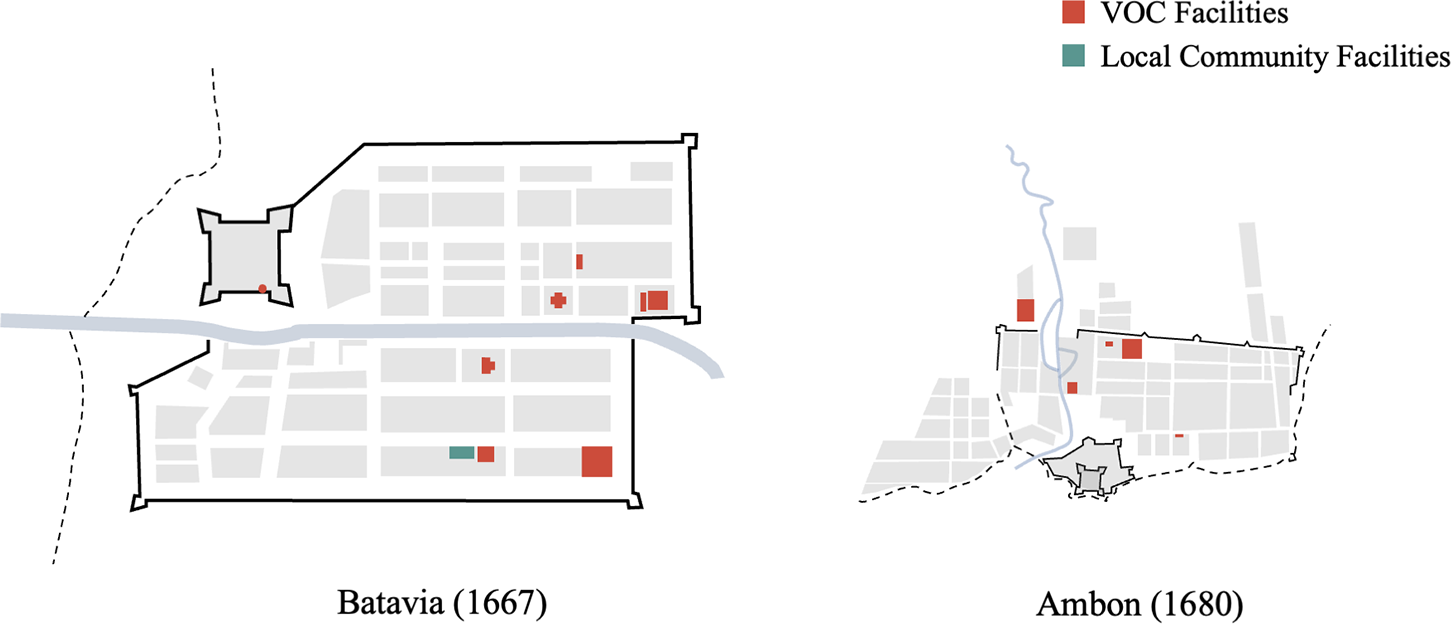
In Company-dominated colonial cities like Batavia, the Asian headquarters and administrative nerve centre, and Ambon, the core area for monopolizing clove and nutmeg production in the Spice Islands, the Company was willing and able to invest immense military, administrative, and economic resources to establish and maintain absolute control, exhibiting strong planning and control over urban form. In Batavia, for instance (Figure 1), after the decisive victory against the Mataram siege in 1629 and the gradual establishment of stable rule, core public buildings symbolizing Dutch order, law, and governance—the town hall, church, prison—were systematically released from within the castle to the city’s central area. In contrast, social welfare and control institutions like hospitals and poorhouses were deliberately planned for the urban periphery.Footnote 69 Ambon’s layout followed a similar center-periphery logic. This spatial arrangement reflected the comprehensive permeation and systematic reshaping of the urban fabric by colonial power, aiming to construct a hierarchical social and spatial order centered on the VOC.
Company-Dominated Cities. Based on (1) Map of the castle and town of Batavia in the year 1667, Museum of the Tropics (Wereldmuseum Amsterdam), Amsterdam, and (2) Description Plan of the Castle Victoria, the city and partly the surroundings of Amboina, number 1328, Nationaal Archief, Hague. (Date unknown, presumed to be a map from the 1680s. This conclusion is based on the presence of a complete city defence system depicted in the map. The defence system of Ambon was constructed in the 1680s and fell into disrepair after 1687. The period depicted in this map should therefore fall between these two dates).

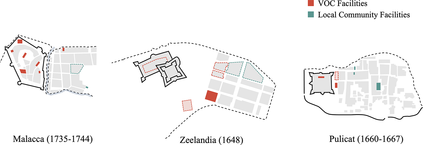
The “fort-town” dichotomous structure seen in Zeelandia, Malacca, and Pulicat presents a stark contrast (Figure 2). In these settlements, facilities typically found at the core of Dutch towns—the town hall, church, cemetery, as well as housing, warehouses, and hospitals for Company employees and Europeans—were highly concentrated within the fort or its immediate vicinity. Conversely, the town, bearing the main commercial and residential functions, was spatially distanced from the fortress and exhibited strong indigenous Asian characteristics, dominated by the residences, markets, and even religious sites of local Asian residents. The clear physical separation between fort and town constituted the most salient spatial feature of these cities.
The “Fort-Town” Dichotomous-Structure Cities. Source: Based on (1) Johann Carl Tetschner, Map of Malakka, 1735–44, Koninklijke Bibliotheek, Hague, (2) Caspar Schmalkalde, Bird’s-Eye View of Zeelandia, c. 1648, in Die wundersamen Reisen des Caspar Schmalkalden nach West- und Ostindien 1642–1652, and (3) Johannes Vingboons, Map of Pulicat, ca.1660–67, Biblioteca Medicea Laurenziana, Florence.

This dichotomous structure conveyed more than mere functional zoning. As urban theorist Marcuse stated, the fort is “created by a dominant group to protect or enhance its superior position”Footnote 70 —an unequivocal assertion of colonial power. Worden’s in-depth study of seventeenth-century Dutch colonial forts offers a more dialectical perspective, noting they embodied “this tension between permanent assertiveness and vulnerability.”Footnote 71 On one hand, the sturdy walls, bastions, and cannons of the fortress proclaimed the colonizer’s resolve and confidence for permanent rule. On the other, the very need to place themselves within a concentrated, heavily fortified structure exposed their lack of dominance in numbers, cultural influence, and social foundations, revealing the inherent fragility of their rule.Footnote 72 Thus, the “fort-town” dichotomy was the spatial expression of this paradoxical mindset—both asserting authority and feeling profound insecurity.
However, in practice, spatial segregation was a choice with trade-offs. For trade-oriented settlements like Zeelandia, Malacca, and Pulicat, with consistently limited military manpower, the VOC, a profit-driven company, faced a difficult balancing act between security and profit, segregation and permeability. On one hand, in a fiercely competitive environment, maintaining high segregation and military readiness was the most direct and effective means of ensuring regime survival. On the other, excessive segregation severely hindered daily interaction, information flow, and commercial transactions with local Asian merchant communities, undermining the fundamental commercial purpose of the settlement.
This compelled the VOC to finely “calibrate” the degree of spatial segregation in each settlement according to its specific circumstances. Consequently, the binary spatial structures observed in Pulicat, Zeelandia, and Malacca were neither homogeneous nor absolute. Instead, they existed along a spectrum of segregation intensity, shaped by the level of external threat—a spectrum that proves key to interpreting the varying mindsets and strategies adopted by the Company in its interplay with different powers.
Pulicat: the “Factory Model” of Cooperative Permeation
Pulicat, on India’s Coromandel Coast, occupied the weakest end of the VOC segregation spectrum. It was established as the regional headquarters for the Coast in 1610, with Fort Geldria (’t Casteel Geldria) built in 1613 and elevated to a “Government” in 1615.Footnote 73 The Company fort and local town here were functionally distinct yet spatially interpenetrated. Its form can be characterized as the “factory model,” where the Company, primarily through negotiation and cooperation with local polities, established a fort for basic military security while exerting a high degree of administrative and economic control over the town housing the local textile industry,Footnote 74 exhibiting great openness in spatial strategy.
This unique form resulted from two key factors: First, the Company was deeply embedded in complex local handicraft production and trade networks, requiring close and frequent interaction with various local communities. As Indian cotton textiles and chintz were in high demand in the Spice Islands, and Pulicat was a crucial textile production and procurement source, the Company’s profit model here heavily relied on controlling, protecting, and cheaply procuring from local producers. Consequently, Pulicat’s town gathered large numbers of local weavers and painters,Footnote 75 as well as Indian, Muslim, and Armenian merchants handling circulation.Footnote 76 This deep economic integration fostered a pattern of frequent and close interaction between Company and local society, fundamentally promoting spatial interpenetration.
Second, the relatively low level of substantive military threat from external actors weakened the intensity and urgency for strict spatial segregation. While the Company’s monopoly textile trade in Pulicat faced constant commercial challenges from competitors like the English and French, similar to Malacca and Zeelandia, these challenges in the seventeenth century seldom manifested as deadly military contests for control. Pulicat never truly escaped the sovereign influence of Golconda or its successor, the Mughal Empire, legally or geopolitically. The Company typically maintained its quasi-sovereign taxing and legislative powers over Pulicat’s fort and town by leasing land or conducting annual interest exchanges with local powers.Footnote 77 This fundamentally established the binary spatial structure and the town’s strong indigenous character, also meaning conflicts with local authorities were often about economic extortion or administrative interference by local officialsFootnote 78 rather than overthrow-seeking military confrontation, somewhat weakening the overall tension between town and fort. Although Pulicat was a core producer of quality cloth, the dispersed nature of supply pointsFootnote 79 and the mobility of labor along the Coromandel Coast gave it a relatively high degree of substitutability. It was not a unique strategic chokepoint like Malacca controlling a strait or Zeelandia as the sole stepping-stone for China trade, making it less likely to attract all-out invasion attempts. For instance, during the same period, the English East India Company chose to avoid direct military confrontation with the Dutch at Pulicat. Instead, it successively established its own fortified settlements at Armagon and Madras, attempting to attract mobile textile producers to its territory with favourable termsFootnote 80 rather than launching a costly military assault against the Dutch headquarter in Pulicat.
Under these combined factors, the physical and psychological boundaries between fort and town in Pulicat became blurred, facilitating daily commerce and administrative management. A city map from the 1660s (Figure 3) shows, on the one hand, a clear functional division existed. The fort served as the core symbol of Company power, concentrating administrative offices, the church, and residences for high-ranking officers.Footnote 81 The town opposite the fort, by contrast, exhibited strong local characteristics. Its main thoroughfare labeled “Moor Street” (de Moorst straat), was lined with a prominent Hindu temple (pagod) at its centre and several other Hindu temples and Islamic-style domed structures throughout, indicating that the town functioned as the primary living space for local merchants, artisans, and the Muslim trading community.
Distribution of Main Public Facilities in Pulicat. Source: Johannes Vingboons, Map of Pulicat, ca.1660–67, Biblioteca Medicea Laurenziana, Florence.

Figure 3 Long description
Map of Pulicat illustrating the distribution of VOC facilities and local community facilities. VOC facilities are marked in red and include the Bot, Fort Houses and Fort Courtyard. These are concentrated in the western part of the map, indicating the administrative and residential area for VOC officials. Local community facilities are marked in blue and include the Pagod, a Hindu temple, located centrally along Moor Street. The map shows a clear division between the fort area and the town, with the fort serving as the core of Company power and the town exhibiting local characteristics with several Hindu temples and Islamic-style domed structures. Moor Street acts as a main thoroughfare, highlighting the town′s role as a living space for local merchants and artisans.
On the other hand, the segregation between fort and town was not absolute, permitting significant spatial permeability. Most notably, unlike Malacca’s wide moat or Zeelandia’s expansive fort square creating buffer zones, the area between Pulicat’s fort and town was occupied by Company fort houses (de huysen cant casteel) and the fort courtyard (’t hoff vant casteel), indicating the Company actively permeated the living and daily life functions of many ordinary employees or soldiers into the town, living alongside the local community. Furthermore, the north-south extending market (Marckt), the large east-west market street (de Groote marckt), and the toll house (tol huys) adjacent to the Hindu temple in the urban center all indicate that the Company’s commercial transactions and tax collection activitiesFootnote 82 were deeply embedded within the town’s core, operating under relatively loose supervision and enabling convenient interaction. This stands in stark contrast to the spatial logic seen in Malacca and Zeelandia, where key administrative and commercial facilities were carefully confined within the fort or placed under its tight surveillance at the town’s periphery.
Zeelandia: The “Confrontation Model” under Dependence and Wariness
In Zeelandia, segregation between fortress and town was strong but not absolute. As the diachronic analysis showed, limited and cautious permeability and exchange occurred during specific peaceful and prosperous periods. Overall, it can be characterized as a pattern of “coexistence under confrontation,” or the “Confrontation Model.”
This model emerged from a fundamental dilemma. Economically, the VOC’s operations in Taiwan depended entirely on Chinese merchants for access to goods, necessitating some spatial openness to facilitate cross-strait trade. Politically and militarily, however, an acute security threat created an extremely strong imperative for segregation. First, the “external agency” it faced constituted a powerful and uncontrollable external threat. The town’s Chinese had myriad political, economic, and kinship ties to the pirate confederations of the southeastern coast, whose naval power and independent commercial interests could at any time fuel intentions to seize Taiwan by force—especially the organized, merchant-pirate Zheng maritime organization, which, after failing to restore the Ming, urgently sought a secure overseas base, posing the most severe challenge to Dutch rule in Taiwan. Second, China’s isolationist policies, Taiwan’s geographical proximity to the southeastern coast, and the VOC’s successive failures to acquire closer bases like Macau or Penghu made Taiwan the Company’s last remaining foothold in the Far East for bulk trade with Chinese merchants. The loss of Taiwan would therefore have severed the VOC’s access to Chinese goods, dealing a devastating blow to its entire East Asian trade network.
This complex mentality of simultaneous dependence on the intervening group and vigilance against its affiliated external actors materialized spatially in Zeelandia’s distinctive confrontational layout—a tense balance between segregation and permeability. The foundational practice of segregating populations between fort and town persisted throughout Zeelandia’s development, as vividly illustrated by the consistent cartographic designation of the urban area as the “Chinees Quartier”Footnote 83 in both the 1635 town planFootnote 84 and the 1644 bird’s-eye view of Taioan 大員.Footnote 85
Yet this segregation was not absolute. It permitted deliberate, though strictly circumscribed, spatial permeation—always calculated to remain within the protective range of the fortress’s heavy artillery. This cannon-defined perimeter neatly enclosed the town’s front blocks, where Dutch and European residents concentrated, along with key facilitiesFootnote 86 (Figure 4). First, according to the 1643 Zeelandia cadastral register, the Dutch and other Europeans tended to cluster in the blocks on the northwestern side of the town, closest to the fortress entrance, considering not only daily convenience but also the ability to quickly retreat to the fortress for safety during emergencies.Footnote 87 Second, core urban governance institutions like the governor’s residence and prison were deliberately located away from the densely populated Chinese town centre from the outset, situated around the fortress square or inside the fortress itself, unlike in Batavia and Ambon where it occupied the central city space. Third, the church serving Company employees and European free burghers did not become a landmark defining the city centre as in other colonial cities. Instead, both the fort church built in the outer fort around 1644Footnote 88 and the later planned town church and attached cemetery in the southwestern corner of the townFootnote 89 remained close to the fort, explicitly within the cannons’ range, ensuring safety even during worship. Fourth, the Company hospital, primarily serving sailors and soldiers, consistently prioritized military security as the foremost principle for its location and expansion. As early as before 1635, the hospital stood on the seaside of the fort square.Footnote 90 By 1648, instead of being relocated to the urban periphery for health or developmental reasons, it was further expanded and its functions reinforced on the original site.Footnote 91
Distribution of Main Public Facilities in Zeelandia. Source: Caspar Schmalkalde, Bird’s-Eye View of Zeelandia, c. 1648, in Die wundersamen Reisen des Caspar Schmalkalden nach West- und Ostindien 1642–1652.

Figure 4 Long description
The map of Zeelandia illustrates the distribution of VOC and local community facilities. VOC facilities are marked in red and include: 1) Governor′s Residence, located near the fortress; 2) Fort Church, positioned within the fort; 3) Town Church and Cemetery, situated in the southwestern area; 4) Town Hall, centrally located; 5) Hospital, near the fort square; 6) Execution Ground, adjacent to the fort. The local community facility, marked in green, is the Chinese Temple, located in the northeastern section. The map provides a detailed layout of the town′s infrastructure, highlighting the strategic placement of VOC facilities within the protective range of the fortress′s artillery, while the Chinese Temple is positioned in the local community area.
Thus, the Company established a unique and stable spatial pattern between fort and town: on one side was the Chinese-inhabited, commercially vibrant yet distrusted town, a foreign and potentially dangerous zone; on the other was the heavily guarded, fully functional fort and a “safe zone” that partially permeated the town but remained under the fort’s protective umbrella and close surveillance. It allowed a certain degree of interaction while maintaining strict monitoring and high alertness towards the town, prepared for complete isolation at any moment.
Malacca: The “Fortress Model” of High Alert and Segregation
Compared to Zeelandia, Malacca occupied the highest end of the segregation spectrum, adopting a highly vigilant “Fortress Model,” primarily due to external threats from numerous and powerful external actors.Footnote 92 On one hand, when the VOC captured Malacca from the Portuguese in 1641, its strategic positioning had shifted towards ensuring military security and controlling the strait, rather than direct trade profit, greatly reducing the Company’s inherent motivation for deep interaction with Asian residents—at that time, Batavia was already the Asian headquarters and trade centre, whose functions highly overlapped with Malacca’s former role. Consequently, Malacca’s commerce was actively downgraded and stifled by Batavia’s leadership for overall Company interests,Footnote 93 reduced to a strategic “watch-post” in the Malacca Strait and a tin distribution centre.Footnote 94
On the other hand, Malacca’s strategic location made it a coveted prize for European rivals challenging Dutch trade monopolies and controlling global routes. The omnipresent, persistent, and potentially lethal threats from these external actors kept Malacca in a state of tense, wartime-ready isolation. As the key meeting point connecting the Indian Ocean, Arabian Sea, and South China Sea—the three major Asian trade segmentsFootnote 95 —and controlling the vital Malacca Strait, the throat of East-West trade, Malacca held an irreplaceably central position in Asian trade networks,Footnote 96 making it a focus of contention for various political and economic forces. Besides facing ongoing resistance from surrounding polities like Johor and Aceh, the VOC had to constantly guard against Portuguese attempts to recapture it, as well as more threatening competition and potential wars from rising European colonial powers like the French and English.Footnote 97 Losing Malacca would destroy Dutch trade and communications between East and West, disrupting their enormous profits from the global spice and textile monopolies.
Therefore, after capturing Malacca, the Company repaired and strengthened the existing fort system: a deep thirty-foot moat was dug around the main fort, making it an island surrounded by water, connected to the town only by a bridge that was closed punctually every night, during conflicts and periods of hostility, completely severing any potential contact between fortress and town.Footnote 98 From a mid-eighteenth-century city mapFootnote 99 (Figure 5), the Company’s defensiveness towards the town was even greater than in Zeelandia. Not only facilities directly serving the Company including the governor’s residence, employee housing, and warehouses, but also the church, cemetery, hospital, and even the private houses of Dutch free burghers were withdrawn from the town and strictly confined within the fort walls, isolated from the external town and under the fort’s tight protection. Conversely, the markets, religious sites, and residential areas of Chinese, Moors, and Malays constituted the main body of the town. Here, the imperative for trade profit yielded to regime survival, prompting the VOC to contract almost all core functions within the solid fort walls, creating a near-absolute, military-driven spatial segregation.
Distribution of Main Public Facilities in Malacca. Source: Johann Carl Tetschner, Map of Malakka, 1735–44, Koninklijke Bibliotheek, Hague. (Source of the 1750 map: Jacobus van der Schley, Map of Malacca, 1750, Koninklijke Bibliotheek, Hague).

Figure 5 Long description
Map of Malacca detailing VOC and local community facilities. VOC facilities are marked in red: Governor′s Residence, Captain′s Residence, Company Garden, Church, Cemetery, Hospital and Orphanage. Local community facilities are marked in green: Malay Temple, Moor′s Mosque (from a 1750 map) and Chinese Temple (from a 1750 map). The map illustrates the spatial distribution of these facilities within the fortified area and surrounding town, highlighting the separation between VOC-controlled and local community areas.
Conclusion
The historical review and spatial analysis of seventeenth-century Zeelandia demonstrate that its “spatial segregation” cannot be understood solely through the internal binary relationship between colonizer and colonized. It must be situated within a broader analytical framework incorporating the crucial dimensions of external actors and the Chinese intervening group. The formation of this unique colonial situation fundamentally stemmed from Taiwan’s special status as an “extraterritorial” region of China: The Ming authorities regarded Taiwan as an “extralegal territory” beyond their administrative jurisdiction.Footnote 100 Yet, its proximity to the China coast made it a geographically advantageous entrepôt, continuously attracting Chinese for trade. These Chinese maintained tight connections in identity, commercial networks, and political allegiance with external power groups on the southeastern coast. This separation between “land jurisdiction” and “people’s allegiance,” distinct from contemporary Macau and Penghu which were within the Chinese administrative system, created space for the Dutch to conquer land and conduct colonization in Taiwan. However, it also planted a fatal flaw in their rule: while the Dutch conquered and established rule over the land, the Chinese intervening group, constituting the economic lifeblood and civic body of the colonial town, were mobile. They were both the lifeblood of the colonial economy and conduits for external influence, resulting in a Dutch colonial authority perpetually accompanied by profound insecurity and a defensive posture.
The spatial strategies of the Dutch colonizers were the external manifestation of this structural dilemma. Whether the strict boundary markers established early on to guard against Chinese and pirates of unclear allegiance, the limited permeation within cannon range during the mid-period Dutch-Zheng cooperation and trade prosperity, or the extreme spatial isolation and monitoring in the final period facing Koxinga’s 國姓爺 threat, these were not merely functional segregations but also reflected the colonial regime’s ambivalent mindset of simultaneous reliance on and wariness towards its dependent economic lifeline—the mobile Chinese intervening group and external actors behind them. When Koxinga, the most threatening “external actor,” resolved to incorporate Taiwan into his domain, this structural contradiction culminated. The VOC’s subsequent reaction – the Batavia headquarters’ lukewarm response to Zeelandia’s pleas for aidFootnote 101 while actively seeking alternatives and cooperation with the Qing government to maintain trade networks – clearly indicated that the Company was ultimately guarding a trade outpost and profit channel, not a territory intended for deep cultivation.Footnote 102 The end of Dutch colonial rule in 1662 was largely attributable to the structural flaw of a colonial model that both depended on intervening groups and was constrained by external actors.
The case of Zeelandia urges us to re-examine the logic of spatial production in colonial cities. This paper argues that a pattern exists in colonial urban social relations and spatial orders, wherein decisive influence is exerted by an “external actor” through an “intervening group.” Within this pattern, the spatial segregation planned and dominated by the colonizer was not solely an active proclamation of occupying and consolidating a superior position. To a significant extent, it was a passive defensive response born of the colonizer’s fear towards an intervening group they could not fully control yet deeply depended upon, and the external actors’ power behind them. The case of Zeelandia suggests that a deeper analysis of colonial cities requires looking beyond their physical boundaries and internal binary relations, expanding the perspective to regional and global trade networks and geopolitical contests, and fully acknowledging the crucial role of external actors and their local agents who, while not directly present, continuously shaped the colony’s destiny. Only then can we glimpse the full picture of colonial urban spatial logic and more profoundly understand the complexity and diversity of colonialism in the age of early global trade.
Acknowledgements
This article is developed and expanded from my master’s thesis. I wish to express my sincere gratitude to Prof. En-yu Huang, whose guidance introduced me to the field of early Taiwanese urban history and laid a solid foundation for this research. I am also deeply grateful to Prof. Guan-mian Xu for his valuable guidance throughout the revision and submission process. Finally, thanks are due to the two anonymous reviewers for their invaluable insights and constructive suggestions, which significantly enhanced the theoretical depth of this study.
Funding statement
This research was supported in part by Doctor and Master’s Research Scholarship for Research in Tainan (2020), awarded by the Cultural Affairs Bureau of Tainan City Government.


 Open access

