Introduction
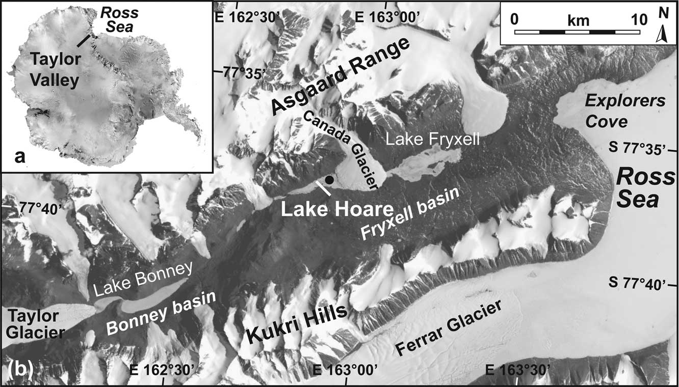
For a better understanding of the mechanisms related to ongoing ice retreat and sea level increase due to recent global warming, a thorough knowledge of past changes in ice extent and deglaciation is indispensable. Recent studies use a large number of radiocarbon and cosmogenic exposure dates to define the Last Glacial Maximum (LGM) and the deglaciation history of the Antarctic and Greenland ice sheets (Clark et al. Reference Clark, Dyke, Shakun, Carlson, Clark, Wohlfarth, Mitrovica, Hostetler and McCabe2009). Most of these dates are from coastal regions, which are the most sensitive regions affected by ice mass changes and relative sea level changes. Present knowledge of the climatic history along the Antarctic coastline, and its impact on the glacial and proglacial environment is mainly based on studies of sediments deposited on the vast continental shelves and in the restricted ice-free coastal areas (Ingólfsson Reference Ingólfsson2004). Lake sediments, in particular, turned out to be suitable archives of climatic and environmental changes, since they are often continuous, exhibit a relatively high resolution due to high sedimentation rates, and provide a relatively good age control by radiocarbon dating (e.g. Doran et al. Reference Doran, Berger, Lyons, Wharton, Davisson, Southon and Dibb1999). Since most of the current ice-free regions in coastal Antarctica did not deglaciate before the end of the LGM, most of the lake sediment records are restricted to the Holocene (Hodgson et al. Reference Hodgson, Doran, Roberts and McMinn2004). Some coastal regions, such as Larsemann and Vestfold hills in East Antarctica, however, are assumed to have remained ice-free during the LGM and thus contain lakes, which probably existed since at least the middle Weichselian (Hodgson et al. Reference Hodgson, Noon, Vyverman, Bryant, Gore, Appleby, Gilmour, Verleyen, Sabbe, Jones, Ellis-Evans and Wood2001, Gibson et al. Reference Gibson, Paterson, White and Swadling2009). The Dry Valleys in the vicinity of the McMurdo Sound, Ross Sea, also remained partly unglaciated during the LGM (Doran et al. Reference Doran, Wharton and Lyons1994) and were occupied by large proglacial lakes (e.g. Hall et al. Reference Hall, Denton and Hendy2000, Reference Hall, Hendy and Denton2006). For example, Taylor Valley (Fig. 1), the southernmost of the McMurdo Dry Valleys, was dammed by the advanced Ross Sea Ice Sheet (RIS) and was occupied by the large and up to 300 m deep Lake Washburn (Hall et al. Reference Hall, Denton and Hendy2000). With the retreat of the RIS after the Pleistocene–Holocene transition, but also as a result of changes in the local hydrological cycle forced by climatic conditions, Lake Washburn lowered significantly (Hall & Denton Reference Hall and Denton2000a). The current lakes in Taylor Valley are believed to be remnants of Lake Washburn (Hendy Reference Hendy2000a).
a. Location of Taylor Valley in Antarctica. b. Landsat 7 satellite image of Taylor Valley, southern Victoria Land, Antarctica, indicating the location of the most important lakes and glaciers. The black dot in Lake Hoare indicates the coring location Lz1020.
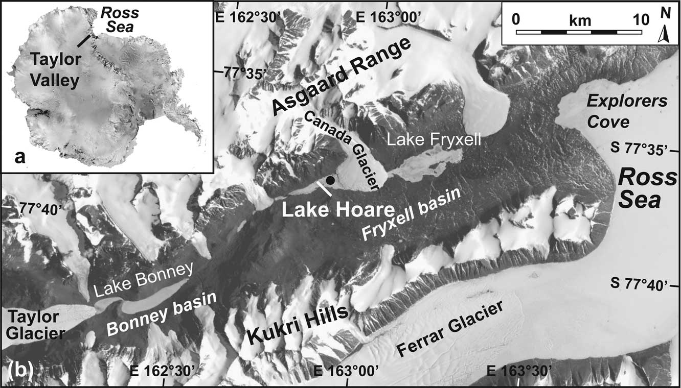
Although the modern processes in the lakes are relatively well-known due to extensive biogeochemical and physical studies conducted within the scope of the McMurdo Long Term Ecological Research (LTER) Program (e.g. Priscu Reference Priscu1998), the detailed history of the lakes is only partly known. Based on diffusion models of elements and isotopic studies of the water columns, significant lake level fluctuations were reconstructed for Lake Bonney in upper Taylor Valley (Poreda et al. Reference Poreda, Hunt, Lyons and Welch2004). In lower Taylor Valley, Lake Hoare is inferred to have completely desiccated c. 1200 years ago (Lyons et al. Reference Lyons, Tyler, Wharton, McKnight and Vaughn1998). Sedimentary sequences were extensively studied only for Lake Fryxell (e.g. Lawrence & Hendy Reference Lawrence and Hendy1989, Wagner et al. Reference Wagner, Melles, Doran, Kenig, Forman, Pierau and Allen2006, Whittaker et al. Reference Whittaker, Hall, Hendy and Spaulding2008), which is located down-valley of Lake Hoare (Fig. 1). These studies revealed distinct lake level fluctuations during the Holocene, the continuous existence of this lake since at least the middle Weichselian, and that final lowering of Lake Washburn from the LGM was induced by evaporation rather than drainage. So far, only short sediment sequences have been recovered from Lake Hoare, providing information about the most recent millennia (Spaulding et al. Reference Spaulding, McKnight, Stoermer and Doran1997, Doran et al. Reference Doran, Berger, Lyons, Wharton, Davisson, Southon and Dibb1999). Here, we present new chronological, physical, mineralogical, and biogeochemical data from up to 2.3 m long sediment sequences from Lake Hoare in order to obtain more information about the history of Lake Hoare and its vicinity.
Study area
The McMurdo Dry Valleys (Fig. 1), located in southern Victoria Land, form the largest ice-free area in Antarctica (4800 km2). The Dry Valleys are protected from the ice masses of the Polar Plateau by the Transantarctic Mountains. Extreme climate conditions, with mean annual valley bottom temperatures from -14.9 to -30.1°C, a mean annual precipitation of < 100 mm yr-1 water equivalent, relatively high ablation rates of 150–500 mm yr-1, a low surface albedo, and dry katabatic winds descending from the Polar Plateau characterize the area (Bromley Reference Bromley1985, Doran et al. Reference Doran, McKay, Clow, Dana, Fountain, Nylen and Lyons2002).
The nearly east–west orientated Taylor Valley (Fig. 1) is part of the McMurdo Dry Valleys. Taylor Valley is 35 km long and bordered by the Taylor Glacier in the west and by the Ross Sea in the east. The valley slopes to the north and south, extending up to c. 2000 m a.s.l., are partly covered with alpine glaciers. The bedrock in the catchment is dominated by early Palaeozoic granitoid plutons, gabbros, and lamprophyre dykes, which are referred to as Granite Harbour Intrusive Complex, and metasediments of the Skelton Group (Laird & Bradshaw Reference Laird and Bradshaw1982, Smillie Reference Smillie1992). Alkali volcanic complexes assigned to the McMurdo Volcanic Group are only sporadically exposed up valley, but are dominant in the southern and eastern parts of the McMurdo Sound, including Ross Island (LeMasurier & Thomson Reference LeMasurier and Thomson1990). Quaternary sediments overlay the bedrock in the lower parts of Taylor Valley (Stuiver et al. Reference Stuiver, Denton, Hughes and Fastook1981).
Taylor Valley consists of three basins, Explorers Cove, Fryxell, and Bonney basins. The Explorers Cove basin at the mouth of Taylor Valley is currently occupied by the Ross Sea and is separated from the Fryxell basin by a sill at c. 78 m a.s.l. Another sill at c. 116 m a.s.l. separates Fryxell and Bonney basins, which are both occupied by perennially ice-covered lakes (Fig. 1).
Lake Hoare (77°38′S, 162°53′E) with a surface area of 1.8 km2 is located at an altitude of c. 73 m a.s.l. in a narrow section of the western Fryxell basin. The bathymetry of the lake shows several sub-basins and a maximum water depth of about 33 m in the north-eastern part of the lake. The perennial ice cover of Lake Hoare is 3.5 m thick on average and is characterized by a very rough surface. High amounts of aeolian sediment are present on and trapped in the ice cover, most probably because down-valley blowing winds are blocked by Canada Glacier at the eastern end of Lake Hoare and thus lose their transport energy in front of the glacier (Wharton et al. Reference Wharton, Simmons and McKay1989, Doran et al. Reference Doran, Wharton and Lyons1994). Also big boulders of up to several meters in diameter can be observed on the ice cover, but their transport mechanisms are still under debate.
The water of Lake Hoare is characterized by low ion concentrations throughout the water column. An oxycline at c. 28 m depth separates anoxic bottom waters from upper oxic waters (Spaulding et al. Reference Spaulding, McKnight, Stoermer and Doran1997, Lyons et al. Reference Lyons, Fountain, Doran, Priscu, Neumann and Welch2000). The perennial ice cover prevents wind driven mixing of the water column and the exchange of gases with the atmosphere (Wharton et al. Reference Wharton, McKay, Simmons and Parker1986). Water temperature is about 0°C below the ice cover, and can rise up to 1°C in the deeper parts of the lake (Wharton et al. Reference Wharton, Simmons and McKay1989). The main source of water is meltwater from Canada Glacier, but seasonal streams also deliver meltwater from snow or snow beds to the lake. Lake Hoare has no outflow, so loss of lakewater is restricted to sublimation at the ice surface or to evaporation from the moat, a narrow zone with open water forming on the lake edges during summer (Wharton et al. Reference Wharton, Simmons and McKay1989, Reference Wharton, McKay, Clow, Andersen, Simmons and Love1992).
Methods
The investigated sediment sequences (Lz1020; 77°37.726′S, 162°52.934′E) were recovered from Lake Hoare during an expedition to Taylor Valley in summer 2002–03. Coring was carried out through parallel holes in the lake ice cover in the north-eastern part of the lake, where a water depth of 32.6 m was measured. A gravity corer (UWITEC Corp., Austria) was used to obtain the uppermost 10 cm of surface sediments in undisturbed conditions (Lz1020-1). Three longer sediment sequences, Lz1020-2 (10–182 cm), Lz1020-3 (0–204 cm), and Lz1020-4 (0–233 cm), were recovered with a piston corer (UWITEC Corp., Fig. 2). After recovery, the piston cores were frozen with dry ice to avoid internal mixing due to flushing water and subsequently cut for transport and storage into 1 m long sections.
In the laboratory, all cores were split using a cutter knife for the PVC tubes and a diamond blade rock saw for the frozen sediments. After macroscopic core description, the gravity core was sampled at 1 cm intervals and the piston cores, Lz1020-2 and Lz1020-4, were sampled at 2 cm intervals. Aliquots of the samples were then pretreated with 10% H2O2 to remove organic matter and sieved at 1 mm. The grain size of the fraction < 1 mm was analysed using a laser particle size analyser (CILAS 1180).
For biogeochemical and mineralogical analyses an aliquot of each subsample was ground to < 63 μm and homogenized. Total carbon (TC) and total sulphur (TS) contents were measured with an Elementar III analyser (Elementar Analysensysteme GmbH). Total organic carbon (TOC) content was determined with a Metalyt CS 1000S analyser (ELTRA GmbH), after pretreating the samples with 10% HCl at 80°C to remove carbonates. Total inorganic carbon (TIC) content was calculated as the differences between TC and TOC. For a determination of the sediment pore water salinity in core Lz1020-4, the salts left in the sediment upon freeze drying were re-dissolved with de-ionized water. The cation and anion abundances of the samples, which were analysed with an Ion Chromatograph DX-120 (Dionex Corp.) at the Byrd Polar Research Center at Ohio State University, were combined to produce a value of total dissolved solids (TDS) and corrected for the original water content in the subsamples (for details see Burkemper Reference Burkemper2007).
Mineralogical analyses were conducted with a miniflex X-ray diffractometer (Rigaku Corp.) with CoKα radiation (30 kV, 15 mA). For a semiquantitative estimation of the mineral content, aliquots of freeze-dried and grounded bulk sediment samples were mixed with an internal standard of Corundum (Al2O3) at a sample/standard ratio of 5:1. Random powder mounts were X-rayed from 3–40° 2Θ with a step size of 0.02° 2Θ and a measuring time of two seconds per step. The diffractograms were evaluated using MacDiff 4.2.5 software (Petschick Reference Petschick2001) and following the method described in Neumann & Ehrmann (Reference Neumann and Ehrmann2001).
Enumeration of volcanic glasses for the reconstruction of sediment provenances was made from the heavy mineral fraction. Heavy minerals were separated from the fine sand fraction (125–250 μm), which was isolated by sieving by using a centrifuge and a sodium-metatungstate solution (density of 2.83 g cm-3) as a heavy liquid. Separated heavy minerals including volcanic glasses were fixed with meltmount on glass slides, and a minimum of 300 grains was counted for statistical significance under a polarizing microscope.
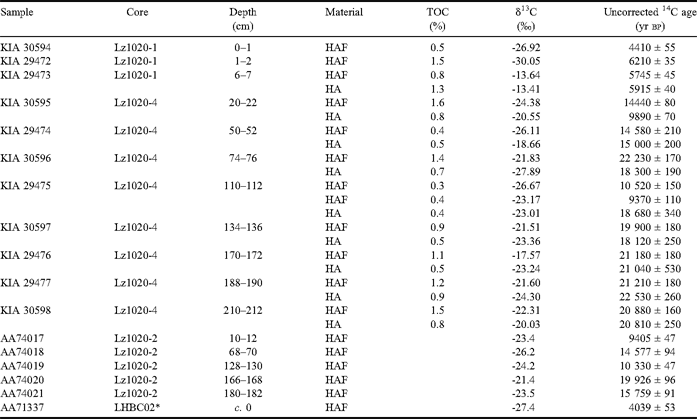
Radiocarbon dating was conducted on bulk sediment samples by accelerator mass spectrometry at both the Leibniz Laboratory for Radiometric Dating and Isotope Research in Kiel, Germany, and the University of Arizona at Tucson, USA. As the TOC contents of most samples (except of the near-surface sediment samples) were < 1%, high amounts of sample material were necessary for obtaining a sufficient amount of carbon. The radiocarbon ages of most samples comprise the ages of the humic acid fraction (HA) and the humic acid free fraction (HAF, Table I), which was obtained by acid-alkali-acid treatment (Grootes et al. Reference Grootes, Nadeau and Rieck2004).
Radiocarbon dates of the humic acid free fraction (HAF), and the humic acid fraction (HA) from bulk sediment samples of cores Lz1020, Lake Hoare.

*surface mat sample of box core (32 m water depth)
Results and discussion
Lithostratigraphy
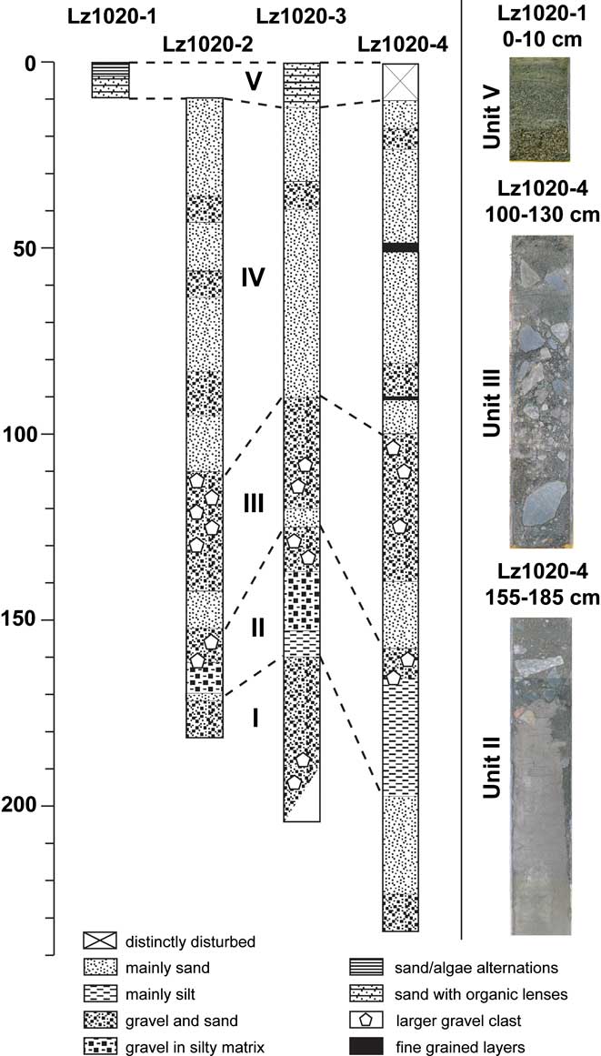
The cores recovered from Lake Hoare are dominated by coarse-grained clastic sediments and show similar lithological successions, despite some variations of the thicknesses of individual horizons. Five lithological units can be distinguished (Figs 2 & 3).
Lithology of Lake Hoare cores, with correlation of the sedimentary units (left) and photographs of significant core segments (right).

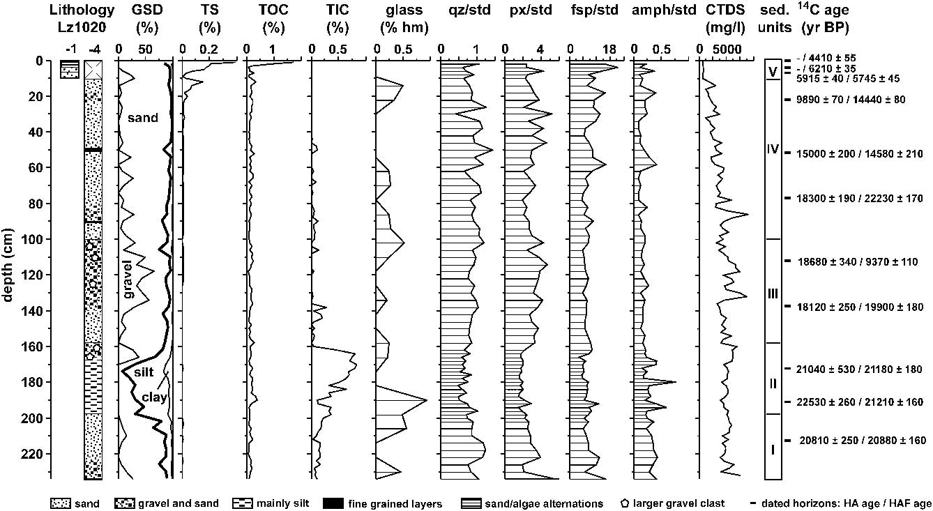
Lithology, grain size distribution (GSD, with cumulative fraction from left to right), total sulphur (TS), total organic carbon (TOC), total inorganic carbon (TIC), volcanic glass content in the 125–250 μm heavy mineral fraction, amounts of quartz (qz), pyroxenes (px), feldspars (fsp), and amphiboles (amph) vs standard (std), corrected total dissolved solids (CTDS), and radiocarbon dated horizons with their 14C ages (yr bp) for the humic acid (HA), and humic acid free (HAF) fraction of cores Lz1020-1 and Lz1020-4 from Lake Hoare.
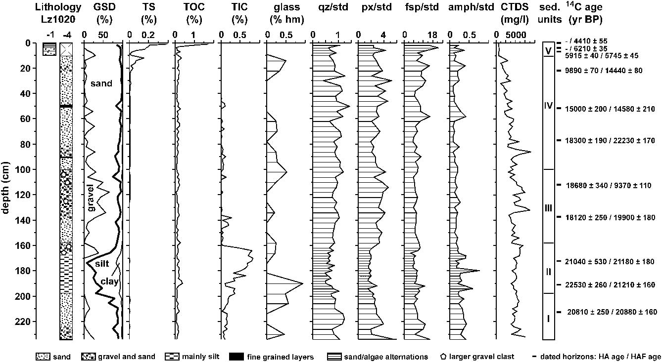
Unit I is composed of silty sand with poorly rounded gravel and forms the bases of the three piston cores (Figs 2 & 3). The thickness of unit I varies between 10 and 40 cm in the individual cores. In core Lz1020-4, the upper part of this unit is characterized by a dominance of sand. The silty and sandy matrix, which forms the main proportion of the sediments in unit I, suggests deposition in a lacustrine environment with apparently moderate transport energy. The occurrence of gravel in unit I can only be explained by glacial related transport. However, the ice cover on Lake Hoare is perennial today and it is inferred that clastic grains > 1 cm cannot melt their way through the ice cover of current dry valley lakes (Hendy Reference Hendy2000b). Hence, the occurrence of medium to coarse gravel in unit I implies a non-perennial ice cover or dropstone release from icebergs, which were drifting as part of the ice cover through proglacial lakes (Hendy et al. Reference Hendy, Sadler, Denton and Hall2000). This drift is caused by an internal lake-ice conveyor, which can transport gravel and rocks that have fallen onto the ice surface by mass movement from the surrounding slopes or glacial debris from the front of the glacier to the moat zone (Hendy et al. Reference Hendy, Sadler, Denton and Hall2000, Hall et al. Reference Hall, Denton and Hendy2000, Reference Hall, Hendy and Denton2006). Since Lake Hoare is inferred to have experienced significant lake level fluctuations in the past, the location and the width of the moat zone probably varied significantly.
Unit II consists of clayey and sandy silt with larger, poorly rounded gravel clasts in the upper part and is thickest in core Lz1020-4, where it occurs between 200 and 160 cm depth (Figs 2 & 3). The similar succession of sediments (mainly silt) between 175 and 155 cm in core Lz1020-2 and between 160 and 130 cm in core Lz1020-3 suggests that these intervals belong to the same unit. By comparing to Hall et al. (Reference Hall, Denton and Hendy2000), unit II could be characterized as a glaciolacustrine silt facies. The mainly silty sediment composition requires relatively calm sedimentation conditions, which are characteristic of large proglacial lakes (Hall et al. Reference Hall, Hendy and Denton2006). The large clasts in the upper part may result from similar processes as those described for unit I.
Unit III is characterized by sand at its base and sandy gravel in its upper part with very large, poorly rounded clasts with diameters of up to 5 cm. It occurs in different thicknesses of 40–60 cm at various depths between 160 and 100 cm in the Lz1020 cores (Figs 2 & 3). Since silt content in unit III is low and clay is mostly lacking, relatively high transport energies during or after deposition of this unit are indicated. This makes a formation by dropstone release from icebergs in a relatively calm environment unlikely. Alternatively, unit III could have been formed as moat zone deposit in a proglacial lake with a lake-ice conveyor belt (Hendy et al. Reference Hendy, Sadler, Denton and Hall2000, Hall et al. Reference Hall, Hendy and Denton2006). The occurrence of bigger clasts in the upper part of this horizon, and the wide absence of fine clastic matter is comparable to recent stone pavements in the surrounding of the lake (McKnight et al. Reference McKnight, Niyogi, Alger, Bomblies, Conovitz and Tate1999). This similarity may suggest subaerial conditions with deflation of the finer sediments during desiccation of the lake.
Unit IV, between c. 100 and 10 cm depth, mainly consists of fine- to coarse-grained sand with some interspersed layers of gravel or clayey silt (Figs 2 & 3). The sand dominated material is similar to that found on the rough ice surface and in the ice cover of Lake Hoare today. Accumulation of the sediments on the surface is mainly related to aeolian transport of down-valley blowing katabatic winds, which are blocked by Canada Glacier. The sediments can then migrate by freezing and thawing processes through the ice cover or can fall through cracks in the ice cover, leading to sand mounds and ridges on the lake bottom (e.g. Nedell et al. Reference Nedell, Andersen, Squyres and Love1987, Squyres et al. Reference Squyres, Andersen, Nedell and Wharton1991, Hendy Reference Hendy2000b). The sorting of sediments during the migration through the ice and the local deposition lead to very variable structures on the sediment surface of Lake Hoare. They could also explain several successions with light coloured coarse sand at the bottom and dark coloured fine sand at the top within unit IV (Fig. 2). The overall very low amounts of fine-grained material are probably caused by the winnowing of fine-grained particles before deposition on the ice and the low number of inflowing streams, which supply glacial meltwater and fine-grained suspension load to the lake.
Unit V forms the uppermost 10 cm of sediments recovered from Lake Hoare and is characterized by horizons of microbial mats of up to a few millimetres thickness, which alternate with coarse-grained sand layers of up to a few centimetres thickness (Figs 2 & 3).
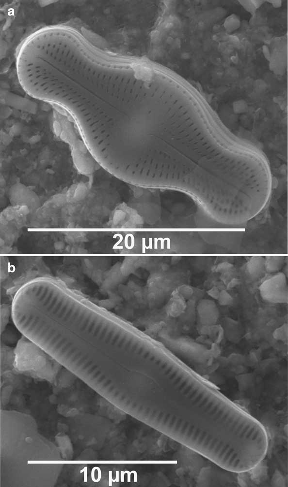
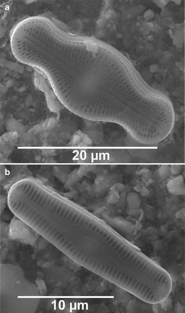
These sediments are also described from previous studies on surface sediments of Lake Hoare (Spaulding et al. Reference Spaulding, McKnight, Stoermer and Doran1997, Doran et al. Reference Doran, Berger, Lyons, Wharton, Davisson, Southon and Dibb1999). Unit V is best preserved in gravity core Lz1020-1, missing in the piston core Lz1020-2, present in Lz1020-3 and disturbed due to the coring process in Lz1020-4. The microbial mats contain a higher percentage of fine material and contain chrysophyceae cysts and diatoms, such as Luticola muticopsis (Van Heurck) D.G. Mann and Pinnularia cymatopleura West & West (Fig. 4, e.g. Spaulding et al. Reference Spaulding, McKnight, Stoermer and Doran1997). The sub-millimetre lamination of these horizons indicates low sedimentation rates, whilst the interspersed sandy layers could reflect higher sedimentation rates or deposition at short-term events, such as the formation of sand mounds and ridges (e.g. Squyres et al. Reference Squyres, Andersen, Nedell and Wharton1991). A similar sedimentation, with alternating microbial mats and interspersed sand horizons, was also observed in the surface sediments of Lake Fryxell (e.g. Wagner et al. Reference Wagner, Melles, Doran, Kenig, Forman, Pierau and Allen2006).
SEM photographs of a. Luticola muticopsis, and b. Pinnularia cymatopleura, in the microbial mats of the surface sediment from Lake Hoare.
Biogeochemistry
Biogeochemical analyses were carried out on the gravity core (Lz1020-1) and on the longest of the recovered piston cores (Lz1020-4).
Below the near-surface sediments TOC contents are very low (< 0.5%) throughout the sediment sequences (Fig. 3), being close to their limits of detection. The low organic matter content can be explained by a generally low productivity induced by low temperatures, low nutrient supply, reduced light penetration through a long-lasting ice cover, as well as relatively high decomposition (e.g. Fountain et al. Reference Fountain, Lyons, Burkins, Dana, Doran, Lewis, McKnight, Moorhead, Parsons, Priscu, Wall, Wharton and Virginia1999, Hodgson et al. Reference Hodgson, Doran, Roberts and McMinn2004). A distinct increase of TOC in the topmost 5 cm of the sediment sequence to 1.6% is caused by the microbial mats (Fig. 3). A similar pattern was observed in the sediment records of Lake Fryxell (Fig. 5, e.g. Wagner et al. Reference Wagner, Melles, Doran, Kenig, Forman, Pierau and Allen2006).
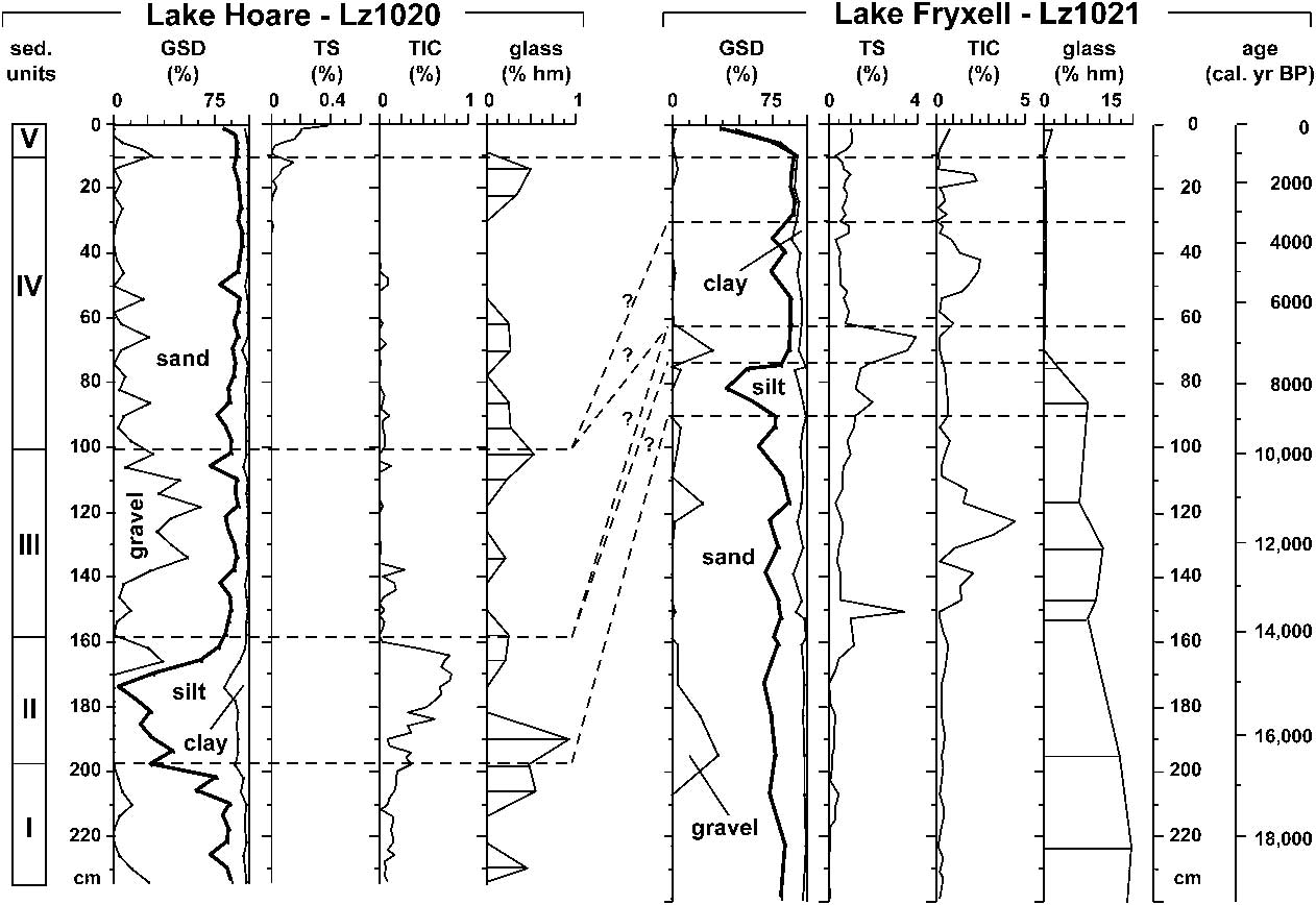
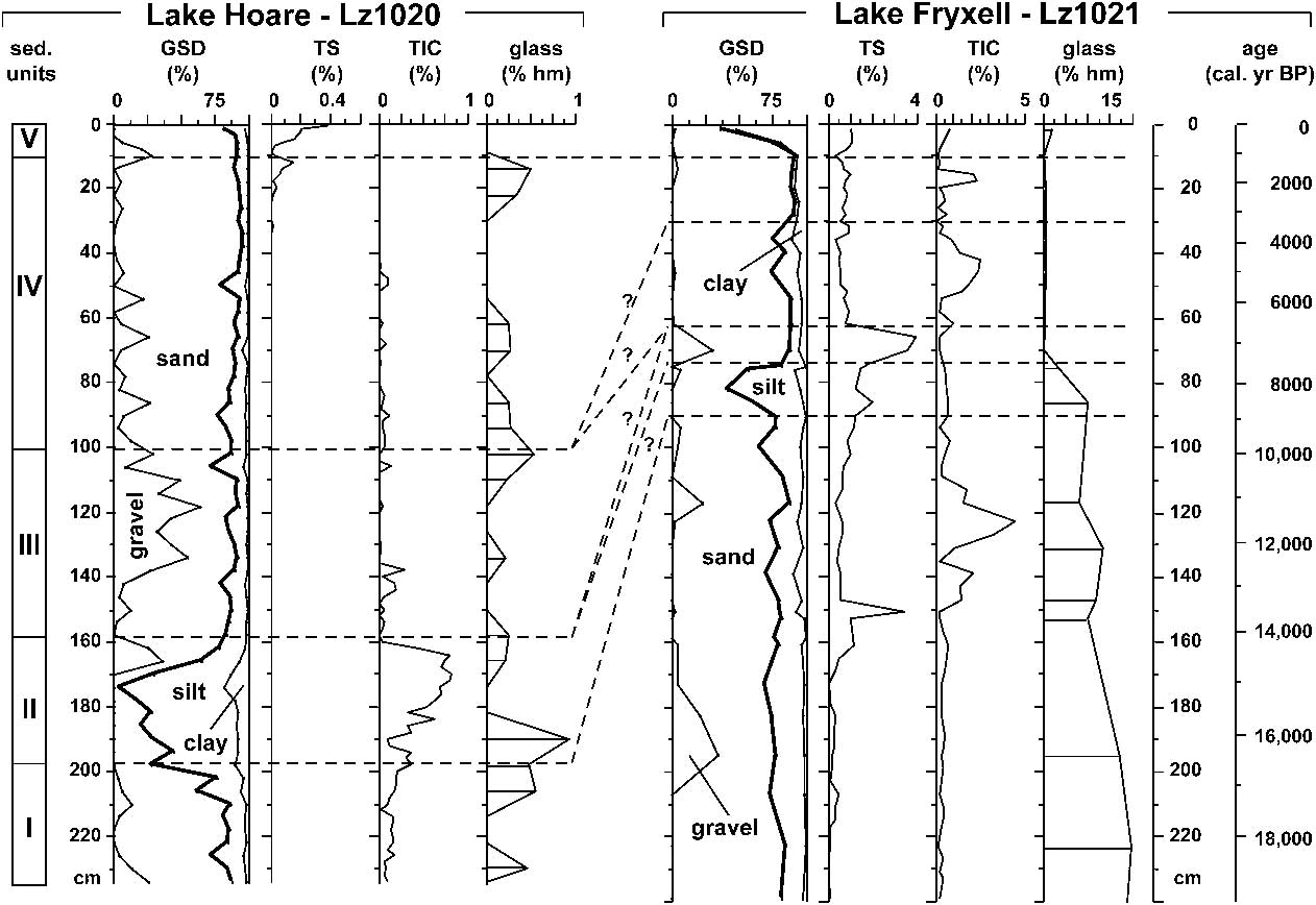
Suggested correlation of cores Lz1020 from Lake Hoare and Lz1021 from Lake Fryxell based on grain size distribution (GSD), total sulphur (TS), total inorganic carbon (TIC), and volcanic glass concentration in the heavy mineral fraction. The age model for the Lake Fryxell record is based on Wagner et al. (Reference Wagner, Melles, Doran, Kenig, Forman, Pierau and Allen2006). Note different scales on x-axes.
Total sulphur is partly related to the amount of organic matter, which explains the low TS (< 0.05%) throughout the core, except for the uppermost 15 cm, where a TS increase to 0.4% at the sediment surface can be observed (Fig. 3). Mismatches between TS and TOC contents, such as indicated at c. 15 cm depth, might indicate the occurrence of pyrite, which is formed under reducing conditions (Håkanson & Jansson Reference Håkanson and Jansson1983). Pyrite is present in near-surface sediments deposited in the deep, anoxic pockets of Lake Hoare (Bishop et al. Reference Bishop, Lougear, Newton, Doran, Froeschl, Trautwein, Korner and Koeberl2001), and in Lake Fryxell sediments (Wagner et al. Reference Wagner, Melles, Doran, Kenig, Forman, Pierau and Allen2006). Total sulphur contents would also increase in horizons where gypsum crystals formed during evaporation events.
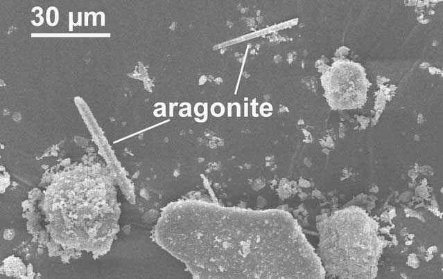
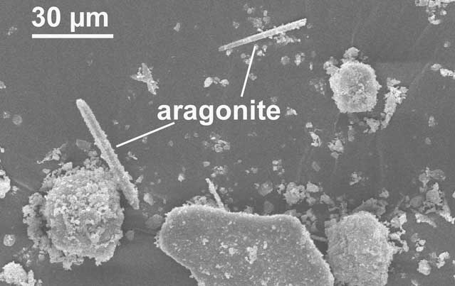
Total inorganic carbon contents are lower than 1% throughout the core (Fig. 3) and most probably reflect the presence of carbonates in the form of calcite or aragonite (Fig. 6). The only significant TIC maximum can be observed in unit II. Calcite and aragonite layers were already found in other sediment cores from the McMurdo Dry Valleys lakes and ascribed to periods of enhanced evaporation and lake drawdown (e.g. Lawrence & Hendy Reference Lawrence and Hendy1989, Hendy Reference Hendy2000a, Wagner et al. Reference Wagner, Melles, Doran, Kenig, Forman, Pierau and Allen2006).
SEM photograph of aragonite needles in 170–172 cm depth of core Lz1020-4 from Lake Hoare.
The values for corrected total dissolved solids (CTDS) are 5000 mg l-1 and relatively constant in the lower part of the core and decrease gradually to 1000 mg l-1 in the upper part (Fig. 3). It is questionable, however, if this decrease reflects decreasing bottom water salinity. Since the Lake Hoare sediments are very coarse-grained, it can be assumed that there is a deep exchange of the lake bottom water with sediment pore water. The relatively low CTDS values compared to the other larger lakes in Taylor Valley can probably be explained by the very low salinity of the Lake Hoare bottom waters.
Mineralogy
The mineralogical data show only small variations in the composition of the Lake Hoare sediments throughout the core (Fig. 3). The contents of quartz and pyroxenes show a slight minimum in unit II, which is most probably related to the shift towards more fine-grained sediments. Feldspar, which may originate from granitoid sources, is the most abundant mineral and shows a slight increase in the topmost 60 cm. This increase could be due to an increased influence of Canada Glacier, which probably delivers to Lake Hoare material eroded from the Granite Harbour Intrusive Complex (Porter & Beget Reference Porter and Beget1981).
The occurrence of volcanic glasses is low in the Lake Hoare sequence and does not indicate a significant maximum. Volcanic glasses were used in a sediment record from Lake Fryxell to infer the proximity and the influence of an advanced RIS, which delivered to the McMurdo Dry Valleys during the Weichselian relatively large amounts of volcanic glass from the McMurdo Volcanic Group of Ross Island (e.g. Denton & Hughes Reference Denton and Hughes2000, Hall & Denton Reference Hall and Denton2000b, Wagner et al. Reference Wagner, Melles, Doran, Kenig, Forman, Pierau and Allen2006). The low amount of volcanic glasses in the Lake Hoare sequence suggests that these glasses originate from local sources in upper Taylor Valley (Angino et al. Reference Angino, Turner and Zeller1962) or that the RIS did not contribute significantly to the sediments in Lake Hoare.
Chronology
The modern microbial mats on top of core Lz1020-1 (sample KIA 30594) yielded an age of c. 4410 14C yr bp (Table I). A box corer sample taken at 32 m water depth provided a surface sediment age of c. 4040 14C yr bp (sample AA71337, Table I). These ages probably indicate the modern reservoir effect at the coring location. However, both ages are significantly older than the surface sediment age of c. 2500 14C yr bp yielded in another core recovered in 11 m water depth from Lake Hoare (Doran et al. Reference Doran, Berger, Lyons, Wharton, Davisson, Southon and Dibb1999). The differences between the surface sediment ages could be primarily due to stratification of the water column, with larger reservoir effects in greater water depths (cf. Hendy & Hall Reference Hendy and Hall2006).
Samples from further down-core in cores Lz1020-2 and -4 show no consistent age increase with increasing depth and yield large variations between HA and HAF ages and between δ13C values (Table I). Several distinct reversals in both cores may have partly been caused by the relatively low amount of organic carbon available for dating (Table I). The low contents of TOC suggest low amounts of in situ produced organic material and poor preservation, and even a low admixture of old, reworked organic material could lead to significantly erroneous ages. As Lake Hoare is inferred to have experienced significant lake level changes in the past (e.g. Lyons et al. Reference Lyons, Tyler, Wharton, McKnight and Vaughn1998, Wagner et al. Reference Wagner, Melles, Doran, Kenig, Forman, Pierau and Allen2006), reworked organic material could originate from older Lake Washburn sediments that were eroded from the surrounding slopes during periods of lower lake levels. The reversals also may be caused by significant changes in the reservoir effect, as glacial meltwater supply, ice coverage of the lake, and stratification in the water column varied significantly and affected the inherited age and the residence age of the lakewater (cf. Hendy & Hall Reference Hendy and Hall2006). Considering all these uncertainties and the inconsistent increase of radiocarbon ages with sediment depth, the establishment of reliable chronologies for cores Lz1020 based on the radiocarbon dates is currently not possible. Other dating methods, such as single grain or multigrain luminescence dating, provide promising results and indicate a sedimentation rate of c. 0.05–0.08 mm yr-1 for near-surface sediments close to the Lz1020 site (Berger et al. Reference Berger, Doran and Thomsen2010). However, the luminescence approach remains to be tested on longer sediment sequences and extrapolation of this sedimentation rate to the deeper sediments of cores Lz1020 is questionable. There are significant spatial variations in sedimentation rates (cf. Doran et al. Reference Doran, Berger, Lyons, Wharton, Davisson, Southon and Dibb1999, Berger et al. Reference Berger, Doran and Thomsen2010) and the lithology of cores Lz1020 changes distinctly throughout, implying distinct variations of the sedimentation rate through time. The radiocarbon ages of cores Lz1020 can hence only be regarded as maximum ages, and indicate that the recovered sediments are younger than c. 23 000 14C yr bp.
In contrast to the unreliability of the radiocarbon chronology of Lake Hoare cores, radiocarbon ages of Lake Fryxell cores provided apparently more reliable tie points to establish age-depth models (Wagner et al. Reference Wagner, Melles, Doran, Kenig, Forman, Pierau and Allen2006, Whittaker et al. Reference Whittaker, Hall, Hendy and Spaulding2008). The differences between both lakes can probably be explained by a much younger age of the Lz1020 cores. Assuming that units I and II were deposited not until the late Pleistocene or early Holocene, when Lake Washburn experienced distinct lake level fluctuations (Hall et al. Reference Hall, Denton and Hendy2000, Wagner et al. Reference Wagner, Melles, Doran, Kenig, Forman, Pierau and Allen2006), local influences, such as re-deposition of organic material from the steeper surrounding slopes or a higher influence of glacial meltwater supply from Canada Glacier, became more important in Lake Hoare and led to erroneous ages.
Overall, the radiocarbon ages of cores Lz1020 allow only vague chronological constraints of the individual lithological units. Comparing and matching significant changes in the sedimentary characteristics of cores Lz1020 and their environmental implications with other published data from sediment cores recovered in the vicinity of Lake Hoare, and with environmental implications derived from other studies of the McMurdo Dry Valleys, are needed to obtain new information about the environmental history of Taylor Valley. However, as different proxies are used in different studies and as the interpretation of these proxies is rarely unambiguous, correlation of events within and across basins is not simple and should be regarded critically.
Correlation of sediment records and environmental history of Taylor Valley
The correlation of the individual cores recovered from the deepest part of Lake Hoare indicates a high spatial variability in terms of grain size distribution and sedimentological structures. The differences between the individual core sequences (Fig. 2) can be explained by highly variable sedimentation conditions in the past, similar to those observed at the sediment surface today (Squyres et al. Reference Squyres, Andersen, Nedell and Wharton1991).
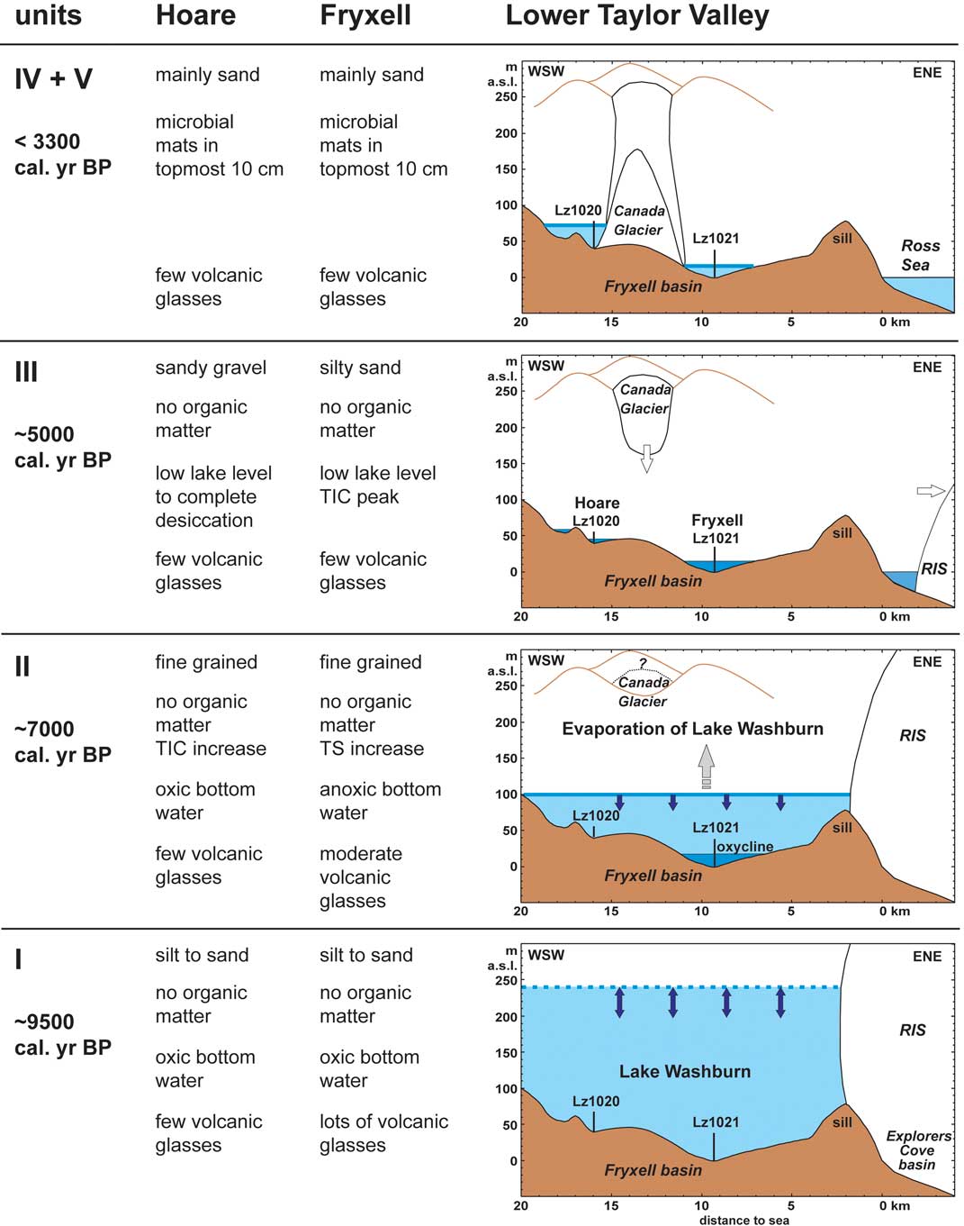
The basal unit I of cores Lz1020 is formed by sand dominated sediments, with some content of silt and angular gravel clasts. The radiocarbon ages of unit I imply that this unit is younger than c. 23 000 14C yr bp, when Taylor Valley was occupied by proglacial Lake Washburn (Hall et al. Reference Hall, Denton and Hendy2000). Studies of deltaic deposits and ancient shorelines in Taylor Valley suggest that Lake Washburn experienced significant lake level fluctuations of up to c. 200 m during the late Weichselian (e.g. Hall & Denton Reference Hall and Denton2000b). These lake level fluctuations were probably triggered by variations in the meltwater supplied by an advanced RIS rather than by evaporation. Besides meltwater, the advanced RIS, which dammed the mouth of Taylor Valley, supplied volcanic material of the McMurdo Volcanic Group from Ross Island to Taylor Valley and to Lake Fryxell (Wagner et al. Reference Wagner, Melles, Doran, Kenig, Forman, Pierau and Allen2006). The distinctly lower amounts of volcanic glasses and amphiboles in unit I from Lake Hoare compared to those of Lake Fryxell could be due to the more distal location of Lake Hoare in Taylor Valley or due to a relatively late deposition, when the influence of the RIS had already decreased. Geomorphological studies (Hall & Denton Reference Hall and Denton2000b, Hall et al. Reference Hall, Denton and Hendy2000) document that a grounded ice sheet at the mouth of Taylor Valley existed at least until 8340 14C yr bp, and the delivery of volcanic glass to eastern Taylor Valley may have lasted at least until 8700 calendar (cal) yr bp. This corresponds with the sediment record from Lake Fryxell (Wagner et al. Reference Wagner, Melles, Doran, Kenig, Forman, Pierau and Allen2006) and implies that unit I of Lake Hoare was probably deposited early in the Holocene at c. 9500 cal yr bp, when the RIS had already largely retreated (Figs 5 & 7).
Unit II is dominated by silt, which implies relatively calm sedimentation conditions. In the sediment record from Lake Fryxell, the only significant increase in fine-grained sediments after the late Weichselian was observed at c. 8000 cal yr bp, when the final lowering of Lake Washburn took place (Wagner et al. Reference Wagner, Melles, Doran, Kenig, Forman, Pierau and Allen2006). A significant increase of TS to a maximum at c. 7000 cal yr bp indicates an increase in salinity and most probably anoxic bottom water conditions, which are related to evaporation and lake level lowering in the Fryxell basin. A similar TS peak around this time cannot be observed in the core Lz1020-4 from Lake Hoare, but there is a gradual increase of TIC (Fig. 5), which suggests increasing ion concentration in the water column. These differences between the Lake Fryxell record and the Lake Hoare record can be explained by their different water depth histories. Lake Fryxell is located at a much lower elevation than Lake Hoare. Hence, lowering of Lake Washburn and increasing ion concentration in the water column probably led to anoxic bottom waters, which primarily affected the deeper portion of the lake at the location of modern Lake Fryxell, but must not have been established in the shallower area of the lake at the site of modern Lake Hoare (Fig. 7). An increased salinity due to lake level lowering at c. 7000 cal yr bp is supported by a coarsening of grain sizes up to sand and gravel in the uppermost part of unit II. The coarsening suggests lake ice thinning or a non-perennial ice cover. A similar coarsening, with occurrence of angular clasts was observed in the Lake Fryxell record at c. 7000 cal yr bp (Wagner et al. Reference Wagner, Melles, Doran, Kenig, Forman, Pierau and Allen2006). These results are supported by another lake level reconstruction of Lake Fryxell (Whittaker et al. Reference Whittaker, Hall, Hendy and Spaulding2008), which indicates a period of lake level low-stand at c. 6500 cal yr bp. Most probably, the period between c. 7500 and 6500 cal yr bp represents the end of Lake Washburn, when Lake Fryxell and Lake Hoare became individual basins.
Four sketches of inferred environmental history of eastern Taylor Valley, reconstructed from the sedimentary units I, II, III, and ‘IV + V’ in cores Lz1020 from Lake Hoare and correlated to the core Lz1021 from Lake Fryxell.
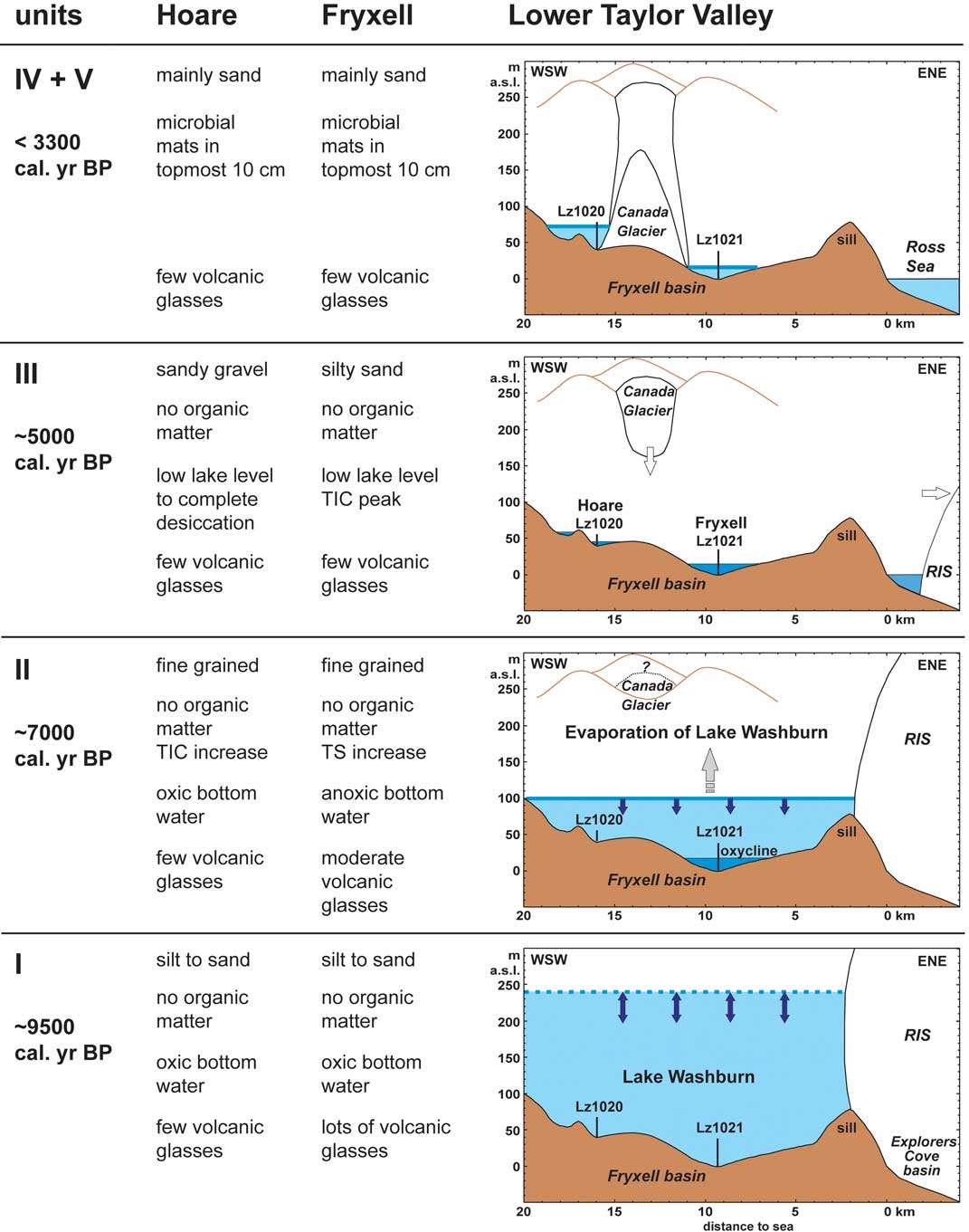
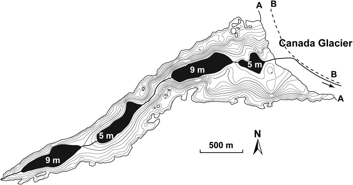
After a short period of sand dominated sedimentation at the base of unit III, which is probably related to a re-filling of the Lake Hoare basin, the very coarse-grained sediments in the upper part of unit III of cores Lz1020 imply a significant change in the depositional environment of Lake Hoare. However, the correlation of unit III with sediment records from Lake Fryxell is very difficult. For example, the relatively high amount of gravel in cores Lz1020 could correlate with the above mentioned occurrence of angular clasts in the Lake Fryxell record at c. 7000 cal yr bp (Fig. 5, Wagner et al. Reference Wagner, Melles, Doran, Kenig, Forman, Pierau and Allen2006). On the other hand, lake level reconstructions from Lake Fryxell indicate a short period of high lake level at c. 5500 cal yr bp and a subsequent relatively long period of low lake level between c. 5000 and 3000 cal yr bp, which is correlated with the deposition of calcareous horizons and an increase of fine-grained particles (Fig. 5, Wagner et al. Reference Wagner, Melles, Doran, Kenig, Forman, Pierau and Allen2006, Whittaker et al. Reference Whittaker, Hall, Hendy and Spaulding2008). A lake level lowering due to evaporation at c. 4000 cal yr bp was also reconstructed for Lake Vanda, which is located in the nearby Wright Valley (Lyons et al. Reference Lyons, Mayewski, Donahue and Cassidy1985). Assuming that a simultaneous lake level lowering also took place in Lake Hoare, which probably exhibited a lower water depth compared to Lake Fryxell at this time, only small remnant lakes may have filled the Lake Hoare basin, or the basin may even have completely desiccated. Although a re-advance of alpine glaciers is inferred to have occurred between c. 6000 and 3000 cal yr bp (Denton et al. Reference Denton, Bockheim, Wilson and Stuiver1989, Hall & Denton Reference Hall and Denton2000b), initial lowering of Lake Hoare was probably promoted by a slightly retreated position of Canada Glacier (Fig. 8) and drainage of Lake Hoare into Lake Fryxell. A complete desiccation and hence subaerial conditions in the Lake Hoare basin during the middle of the Holocene (at c. 5000 cal yr bp) are inferred from the dominance of gravel and sand and the low amounts of silt and clay in unit III. Such a grain size composition is typical for lag deposits, which lack the fine-grained material due to aeolian erosion. The lowering and desiccation of Lake Hoare is probably related to a retreat of the Ross Ice Shelf (e.g. Conway et al. Reference Conway, Hall, Denton, Gades and Waddington1999), to open water conditions in the Ross Sea (e.g. Emslie et al. Reference Emslie, Coats and Licht2007) and to warmer temperatures between c. 6000 and 4000 cal yr bp as indicated from the Taylor Dome ice core record nearby (Steig et al. Reference Steig, Morse, Waddington, Stuiver, Grootes, Mayewski, Twickler and Whitlow2000). However, the complex interplay of different factors, such as temperature, wind activity, precipitation and local glacier movements make an unequivocal interpretation very difficult.
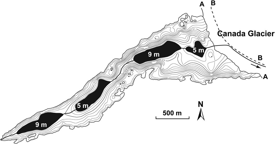
Bathymetry of Lake Hoare (www.mcmlter.org/mapping.htm, accessed 9 September 2010) showing current (solid line at A) and retreated (dashed line at B) glacier positions, along with remnant ponds (with approximate depths) and streams, which may have remained during a retreated glacier (modified from Burkemper Reference Burkemper2007).
The sediments of unit IV, with a grain size composition similar to the sediments found on the ice cover of Lake Hoare today, and with increased amounts of feldspar, which probably originates from the Granite Harbour Intrusive Complex, imply that environmental conditions became similar to those of today and that an advanced Canada Glacier separated Lake Hoare and Lake Fryxell. According to the cross correlation with other cores from Lake Fryxell, these conditions must have established late in the Holocene, i.e. during the past c. 3300 cal yr bp (Fig. 7). The relatively uniform sediment characteristics throughout unit IV suggest relatively stable environmental conditions. The only indication for a period of lower lake level, such as recorded in Lake Fryxell around or shortly after 1800 cal yr bp (Wagner et al. Reference Wagner, Melles, Doran, Kenig, Forman, Pierau and Allen2006, Whittaker et al. Reference Whittaker, Hall, Hendy and Spaulding2008), comes from a TS peak at c. 15 cm depth in cores Lz1020. However, this peak might alternatively indicate that the oxycline, which is established at c. 28 m water depth today (Wharton et al. Reference Wharton, McKay, Clow, Andersen, Simmons and Love1992), probably formed sometime late in the Holocene and was absent before. There is also no indication for draining events, which implies that Canada Glacier did not retreat significantly beyond its present position (Burkemper Reference Burkemper2007). In contrast, the absence of TIC in the upper 40 cm of composite core Lz1020 and the decrease in the CTDS values (Fig. 3) argue for a re-filling of the Lake Hoare basin with freshwater following the period of low lake level during the middle of the Holocene. Our results are in good agreement with those derived from the study of a short (38 cm) sediment sequence recovered at c. 11 m water depth in Lake Hoare. High-resolution radiocarbon dating on microbial mats of this core indicated a continuous sedimentation since 2500 cal yr bp and provided only weak evidence for a desiccation event at c. 1200 cal yr bp (Doran et al. Reference Doran, Berger, Lyons, Wharton, Davisson, Southon and Dibb1999), as inferred to have occurred based on the stable isotope studies from the water column (Lyons et al. Reference Lyons, Tyler, Wharton, McKnight and Vaughn1998). However, as a robust chronology on our cores does not exist, we cannot completely exclude that this inferred desiccation could correspond to the lake level low-stand during the middle of the Holocene reconstructed from the Lz1020 cores.
The uppermost 10 cm in the Lz1020 sediment sequences from Lake Hoare, represented by unit V, reflect the most recent sediment conditions in Lake Hoare. Microbial mats alternate with coarse-grained sand layers. A similar sedimentation was observed in the surface sediments of other cores from Lake Hoare (Spaulding et al. Reference Spaulding, McKnight, Stoermer and Doran1997, Doran et al. Reference Doran, Berger, Lyons, Wharton, Davisson, Southon and Dibb1999) and in surface sediments from Lake Fryxell (e.g. Wagner et al. Reference Wagner, Melles, Doran, Kenig, Forman, Pierau and Allen2006). Despite the occurrence of the microbial mats, the sedimentary characteristics do not differ significantly from those in the underlying unit. The occurrence of the microbial mats indicates that the environmental conditions were relatively stable and that organic matter is only slightly, if at all, decomposed after the establishment of an oxycline in the water column.
Conclusions
The sedimentological investigation of up to 2.3 m long sediment sequences (Lz1020) from the deepest part of Lake Hoare, Taylor Valley, southern Victoria Land, Antarctica, indicates a high spatial variability in the sediment architecture of the lake. Significant differences occur in the depth and grain size composition of the individual cores. Radiocarbon dating for the establishment of a reliable chronology of the cores failed, since Lake Hoare was probably significantly affected by re-deposition of organic matter from the steep surrounding slopes and glacial meltwater inflow from Canada Glacier. Cross correlation of the sedimentological characteristics of the Lake Hoare sequences with the relatively well-dated Lake Fryxell sediments and with other records from the region indicates that the cores from Lake Hoare probably cover most of the Holocene.
The Lake Hoare sediments suggest that the final lowering of proglacial Lake Washburn was not gradual and rather characterized by at least one major re-filling. This is indicated by silt–sand dominated sediments at the base of the recovered cores, which are overlain by fine-grained sediments with increasing carbonate contents and assigned to have been deposited early in the Holocene (> c. 7000 cal yr bp). A unit with very coarse-grained sediments deposited on top of these fine-grained sediments indicates complete desiccation of Lake Hoare with subaerial conditions probably during the middle of the Holocene at c. 5000 cal yr bp. According to cross correlation with a sediment record from nearby Lake Fryxell, re-filling of the Lake Hoare basin occurred at the beginning of the late Holocene and was probably related to an advance of Canada Glacier, which separates lakes Hoare and Fryxell today. A late Holocene desiccation, as reconstructed in former studies, is not observed in the Lake Hoare sediment records. Instead, the sedimentation conditions apparently were relatively stable, except for the formation of an oxycline. This oxycline probably led to an increase of organic matter and sulphur in the surface sediments, and is located at 28 m water depth today. The overall coarser sediments in Lake Hoare compared to Lake Fryxell are probably related to generally lower water depths and a higher influence of mass movement deposits from the steeper surrounding slopes.
Acknowledgements
This project was funded by the German Research Foundation (DFG, grant no. ME 1169/11) and by the National Science Foundation (OPP 0096250, 0126270). Peter Glenday, Jennifer Lawson Knoepfle, and David Mazzucchi are thanked for their assistance in the field. Special thanks are due to Holger Cremer for the determination of diatoms. Claus-Dieter Hillenbrand, John Gibson and Alan Vaughan provided valuable comments and suggestions to improve the manuscript.