


From now on, every [dead] body will receive the service of a Brahmin … such bodies are burnt as promiscuous heaps in [the crematorium of] Topsia. From now on, they will be burnt at Nimtolla.
Hindu Satkar Samity, in its inaugural Annual Report of 1932.Footnote 1
Introduction
The history of Calcutta’s crematorium in Topsia remains a footnote in the city’s otherwise established historiography. But this quote from the manifesto of the Hindu Satkar Samity (HSS) cremation charity reveals discussions on an overlooked spatial and caste politics that contributed towards the solidification of Hindu identity in Calcutta.Footnote 2 Through the works of the HSS, this article explains how Hindu nationalists in Calcutta (present-day Kolkata), both within and outside the municipal administration, mobilized caste, poverty, and communal tensions to materialize Hindu space in interwar Calcutta. It does so by studying the intended and unintended technological, financial, and spatial fallouts of Calcutta’s mechanical crematorium, as it became the target of attacks by the HSS. Established in 1926 and fully operational by 1930, Calcutta Municipal Corporation’s (CMC) crematorium was perhaps one of the most successful of its kind globally. In 1931, it cremated about 2,000 unclaimed corpses from 30 hospitals and a police morgue.Footnote 3 However, in 1935, the crematorium received only 200 corpses, a 90 per cent decrease in numbers.Footnote 4 This drastic shift was the result of the HSS’s successful campaign to swiftly dismantle the crematorium’s centrality within three years.
The HSS was formed by municipal members like Sanat Kumar Roy Chowdhury and Prabhu Dayal Himatsingka, alongside Calcutta High Court judge Ramaprasad Mukherjee, and renowned Indian capitalists such as Ghanshyam Das Birla and Debi Prasad Khaitan. The HSS was associated with the Hindu Sabha and aligned with nationalists advocating for upper-caste Hindu dominance in public institutions and forging a robust anti-Muslim political front.Footnote 5 The HSS criticized the crematorium for its role in altering spatial and labour norms of death rites: HSS members denounced the crematorium’s location in Topsia, on the eastern border of the city. They argued that the bodies of Hindus deserved rituals at Nimtala Ghat, located along the sacred Hooghly River on the city’s west (see Figure 1). Regarding caste, the HSS complained that Dom workers, that is, Dalit mortuary workers, were usurping the priestly duties of Brahmins in Topsia, and that the crematorium fostered such irreligiosities.Footnote 6 The HSS also inflamed sentiments against Muslim leadership, claiming that only unclaimed corpses of Hindus were disposed of in this new technological and irreligious way. By the end of British rule in 1947, the HSS had become the primary charity for all unclaimed bodies identified by hospital authorities as Hindus, and granted such corpses the promised rituals at Nimtala along the river. This article asks: why did the HSS reorganize spaces of cremation, and how did it achieve this success? How did urban technologies mediate and gird its politics around property, space, and rituals, to lead to such marked success? By analysing these questions, this article offers a colonial material history of the construction of emotional resonance in ‘Hindu spaces’ in India, outlining how it emerged at the interstices of communal and caste boundaries.Footnote 7
Map showing the crematorium in Topsia (top right) and the Nimtala Cremation Ghat (top left). Base Map: Survey of India, City of Calcutta: Sociological Map (London: Taylor, Garnett, Evans & Co., 1910). Source: Harvard Map Collection, Harvard Library. This map is not to scale and is intended for illustrative purposes only.

Figure 1 Long description
The map titled 'City of Calcutta Sociological Map' displays the layout of Calcutta with marked locations for Nimtala Ghat and Topsia Crematorium. The map includes an index listing various neighborhoods and their corresponding numbers. Nimtala Ghat is marked towards the top left, while Topsia Crematorium is marked towards the top right. The map features detailed street layouts, water bodies and other geographical elements, providing an illustrative overview of the city's spatial arrangement.
Recent works have shown that studying the intellectual histories and the rhetoric of communalism in India is not enough to explain how some spaces were rendered ‘Hindu’ in dominant discourses.Footnote 8 A spatial and material history of communalism, therefore, must examine how communal ideas mobilized both caste-based and technological and logistical practices to enforce everyday spatial boundaries.Footnote 9 To address these dynamic set of causalities towards the spatialization of Hindu nationalism, the HSS’s anti-crematorium movement is a valuable case study: we can see how the logic of homogenizing (and Brahminizing) death rituals to create a singular caste-hegemonic ‘Hindu’ death depended on multiple material strategies, including property valuations that depended on caste, the crisis of the poor accessing death rites, and the ritualistic and logistical impact of technologies. I argue that such material practices offer us a history of how ascriptive and modern economic practices amalgamated to create a homogenous concept of Hindu spaces in everyday practices. This process, in turn, helps us understand caste and property-related arguments that underlie the anti-Muslim discourses shaping Hindu nationalism in India.
Topsia played a central role in materializing the HSS’s arguments in support of a Hindu space. Existing works on labour and urban histories of colonial Calcutta do not usually focus on Topsia.Footnote 10 Asok Mitra, the census commissioner of India from 1965 until 1968, pithily remarked that while the Topsia region was a ‘gold mine in the city’s backyard’, Calcutta’s administration as well as its mainstream civic politics unfailingly ignored the region and its people.Footnote 11 However, the HSS’s annual reports and the municipality’s public health records reveal the vital role of this region in the city’s cultural and economic landscape. This article draws upon urban studies arguments that the creation of property depends on social contexts, and shows how, to mark Topsia as economically valuable in the twentieth century, the region had to be physically emptied of its association with caste-stigmatized labour practices, including the technological cremation of unclaimed dead bodies where Dalit workers provided most mortuary work.Footnote 12 In the end, the HSS was successful: Topsia became known as the site of bad death from which the HSS perpetually rescued its people, and Nimtala became the site of good, dignified death.
However, I also ask the question: would the politics of the HSS have been the same if the crematorium did not exist? This article demonstrates how municipalities assigned to urban technologies the role of mediating the connection between caste and religious identities and the imperatives of modernist visions, such as efficiency and real estate speculation. As historians have noted, these connections became characteristic of a specific technological modernity in South Asia.Footnote 13 Yet, the outcomes and impacts of an urban technology are not limited to the intentions and visions of its proponents or detractors. This article shows how the crematorium impacted the material practices of death disposal in the city in unintended ways. For instance, the crematorium’s distance from hospitals became a practical weakness that the HSS exploited. Existing studies on the communal histories of colonial South Asia often neglect the politics shaped by such built infrastructures that were installed under colonial rule. This limitation confines discussions of colonialism’s impact to electoral politics or overt state power during crises, and extends a technological analysis of communal violence mainly to post-colonial contexts.Footnote 14 This article instead situates the crematorium and its location also as integral to the politics it shaped, highlighting how politics become entrenched in the technology’s advertised roles, functions, and dismantling.Footnote 15
The article examines the fall of the crematorium and the successes of the HSS in four sections. The first section discusses the HSS’s founding motivations, using annual reports from 1932 to 1947 to illustrate its reorganization of concepts of caste, labour, and community in death rites. This occurred within the context of key electoral transformations in colonial India, particularly through the Communal Award and the Poona Pact (1932). The second section examines the prehistory of the HSS, focusing on Sanat Kumar Roy Chowdhury, one of the HSS’s founders, who from 1925 was invested in urban renewals and the improvement of Topsia and its neighbouring locality, Entally. The third section examines the role of hospital administrators as key brokers of the HSS’s ideas from 1935 to 1943, highlighting the power of collaborations with P. D. Himatsingka and D. P. Khaitan, who provided logistical and financial solutions that facilitated the HSS’s success. Finally, the fourth section analyses the HSS’s expansion during the 1943 famine and 1946 riots, arguing that these crises consolidated its influence and impressed its spatial logic on a larger public. Ultimately, examining caste power and communalism through the lens of space demands an engagement with the profound grief of separation, Partition, and segregation—a grief that is fundamentally tied to space and nationalisms, and which continues to mark the lived experiences of people in the region.
‘Flesh separating from the bones’: The creation of the maimed Hindu body in 1930s Calcutta
One of the founders and councillor of the municipality, Sanat Kumar Roy Chowdhury, wrote a lengthy introduction to the HSS’s first annual report, effectively marking it as the group’s manifesto. Roy Chowdhury was the secretary of the Bengal Hindu Sabha, a municipal councillor, and later the mayor of the CMC from 1937 to 1938, by which time the HSS had stabilized its success.Footnote 16 In 1932, he outlined a new issue for Hinduism posed by the crematorium:
One of the most common desires born of deep-rooted sentiments cherished by every Hindu, however humble and lowly he may be, is that after his death, his earthly remains may be disposed of by his people, according to the Sastras. But unfortunately, how the Government, the Police, and the Hospital authorities in Calcutta have treated the unclaimed dead bodies of Hindus has outraged this sentiment from day to day for a long time. Such bodies are burnt either in a promiscuous heap in Tapsia on the bank of an open sewage channel or decomposed until the flesh is separated from the bones to be ultimately used for various medical and commercial purposes … The dead bodies of Hindus alone are singled out for such treatment, as those belonging to other communities are handed over to some organizations of their communities … [The HSS’s] establishment is the result of the growing resentment of the community against the above revolting practice and the desire to render the much-needed service to the poor and the helpless people of the Hindu Society … from now on, now on, they will be burnt at Nimtolla [emphasis in original].Footnote 17
Topsia was a demographically stigmatized space in the Bengali-dominant caste Hindu imagination, due to both caste and religion-based rigidities. According to the 1931 Census, Topsia was a region inhabited by migrants, comprising a diverse community: two-thirds identified as Hindu, a sizable portion categorized as ‘low caste’ in the census, and a third identified as Muslim.Footnote 18 In contrast, 90 per cent of Nimtala’s population were Hindus, most of whom were born in Calcutta, with a small Muslim population of about 6 per cent; no explicit references were made to caste compositions.Footnote 19 In Figure 2, Ward 2, corresponding to the region of Nimtala, shows a strikingly homogeneous population of Hindus. In contrast, the area associated with the Topsia crematorium (at the outer border of Ward 18, in the suburban municipality) records around 20 per cent of Muslims. In other words, in the upper caste Hindu imagination, death in Topsia meant death in the vicinity of Muslim residences and questionable caste identities.
Population of Muslims in Calcutta. Source: A. E. Porter, Census of India, 1931. Vol. VI: Calcutta. Part I (Calcutta: Superintendent of Government Press, 1932), p. 100.

Figure 2 Long description
The map illustrates the distribution of Muslims per thousand of the total population in each ward of Calcutta and Howrah, including two suburban municipalities, in 1931. Different patterns represent various density ranges: less than 60, 60 to 110, 110 to 175, 175 to 220, 220 to 275, 275 to 400, 400 to 450, 450 to 500 and 500 and over. The map includes labels for specific areas such as South Suburban Municipality and Howrah Municipality, with distinct patterns indicating the density of the Muslim population in each region.
Nimtala’s cremation ground, on the contrary, evoked the comforts of demographic homogeneity, sacredness, and zamindari (landholders) patronage. Despite the advertised timelessness of its sacredness in Nimtala, its exalted status also had colonial roots that can be traced back to a controversy in 1854. Governor of Bengal Cecil Beadon attempted to remove cremation grounds outside the city but failed due to local agitations. The influential Landholders’ Association successfully lobbied for Nimtala’s retention due to its proximity to the river and raised funds for its renovation.Footnote 20 The colonial state ceased intervening, and the cremation ground became a site of native (Hindu) assertion of autonomy over sacred space.Footnote 21 Before the establishment of the crematorium, unclaimed bodies were often buried in adjacent grounds such as Kashi Mitra Ghat. But to the HSS, Nimtala was an appropriate site to appeal to the sense of a sacred and patronizing Hindu community.
The crematorium allowed the HSS to claim that it was rescuing dead bodies from the general apathy of administrators. Roy Chowdhury offered various overlapping examples to viscerally depict violations on Hindu dead bodies without explicitly naming any ‘other’. However, readers of the annual reports, many of whom worked in the municipality and medical institutions, would have been familiar with the subtexts against both Muslim leadership and Dalit workers. For instance, the HSS claimed to offer ‘all bodies’ (irrespective of the deceased’s caste) a ritual by ‘their own people’ (thereby alienating Dalit workers), while also effectively usurping the family’s role. The rhetoric also targeted a Muslim ‘other’: Roy Chowdhury’s focus on ‘flesh separating from the bones’—a process of maceration for anatomical objects like articulated skeletons—was surely a veiled attack on Khwaja Nazimuddin, Bengal Legislative Council’s education minister, who was also in charge of medical colleges and president of the Calcutta-based Sunni Muslim burial charity Anjuman Mufidul Islam (established in 1905). The HSS routinely published questions posed to Nazimuddin in the Bengal Legislative Council regarding the dissection of Hindu bodies. Nazimuddin periodically responded that medical education could not continue without access to unclaimed bodies, and that the scarcity of unclaimed Muslim and Christian bodies was due to existing Christian and Muslim charities that had claimed these dead for several decades.Footnote 22
For the HSS, the violation of caste and religious boundaries became a powerful tool to evoke horror, chaos, and sacrilege, and gave literary heft to Roy Chowdhury’s attacks on Nazimuddin’s office. Roy Chowdhury complained that Dalit workers performed macerations in Topsia’s sewers, implying they were part of Nazimuddin’s design to use Hindu bodies for dissection. The term ‘promiscuous heap’ itself conveyed urgent material and conceptual violations. This English phrasing evoked immediate Victorian literary images of poverty and death, having been used to describe pauper burials in England’s potter’s fields and mass cremations during famines in Ireland or India. The term thus quickly signalled the breach of sacred and profane boundaries. In Topsia’s context, it became a phrase signalling the breach of caste and community boundaries to dishonour the unclaimed body, which was simultaneously signified as Hindu. Roy Chowdhury marked the crematorium as technology that materialized these breaches on community boundaries through dismemberment:
People who have not seen must have smelt the stenches issuing from cremation where the head of one person was burning with the leg of another and the hand of a third … Obsessed with what the Bengalee Hindu thought was the crying need of the hour, he never found time to apply his mind to this problem.Footnote 23
By invoking the stench of bodily promiscuity, the HSS report directly appealed to the reader’s senses, creating a visceral horror that warned of profound corruption. It carried obvious caste connotations: stench often marked stigmatized professions like leather work, performed by Dalits and Muslims alike, many of whom lived in Topsia.Footnote 24 Roy Chowdhury’s narrative then moved from descriptions of brutal disregard to highlighting the plight of Bengali leaders, who, according to him, had always been burdened with protecting their community’s integrity throughout India’s colonial history, but did not have the time to look after their integrity in death. He aimed to construct a collective object for shared grief and anger, while simultaneously excusing prior inaction.
The document continued to re-emphasize promiscuity, which also focusing on gendered violations, blaming the colonial medical schools for this horror. Allusions to attacks against the Muslim ‘other’ came to prominence once again:
Many of Calcutta’s citizens must have never been inside the Dissection Halls of the City’s numerous Medical Colleges and Schools. Those who have will recollect with horror the sight presented to their eyes of all parts of the human anatomy lying bare on tables. They must have seen stark naked bodies (male and female) of unfortunate people being dismembered by medical science students. If they had cared to enquire … they would have come to know that only the Hindu dead bodies are so treated [emphasis in original].Footnote 25
The paragraph escalated the notion of violation: emphasizing the lack of distinction between the sexes, and asserting that naked bodies of both men and women were subjected to dissection, the paragraph served as a potent euphemism. Dissection thus evoked horrific images of sexual and moral violations against the Hindu body. This rhetoric could also appeal to concurrent rhetoric that Hindu men needed to be vigilant to save their women from Muslim men, often couched in anti-migrant terms.Footnote 26 Through death, Roy Chowdhury’s writings could also lay claim to the vulnerability of Hindu men. A veiled criticism of Dalit labour was evident, as the practical tasks of procuring, cleaning, and making initial incisions lay with Dom workers in the hospital: In 1937, HSS member Narendra Nath Das Gupta asked the Bengal Legislative Assembly: ‘Is the honorable minister aware that it is repugnant to the feelings and sentiments of the Hindus and their shastras if their dead bodies are touched by others outside the Hindu Community?’, to which Nazimuddin replied: ‘I am afraid it is a matter of opinion.’Footnote 27 Given that the majority of the students in Bengal’s medical institutions were Hindu, ‘others’ could only mean Dalit workers and the few Muslim medical students.Footnote 28
The categorization of such new forms of violence was the HSS’s way of politicizing unclaimed bodies and carving a sense of Hindu victimhood in the process. These ideas, however, emerged from two distinct contexts: a nineteenth-century colonial policy regarding death management, and the more immediate effects of the Government of India’s interwar policies on community-based representative politics. The former stemmed from a mid-nineteenth-century colonial policy that ideally death was to be handled by community-based authorities rather than the state. The Government of Bengal established the Christian Burial Board (1881) and the Mohammedan Burial Board (1889) to allocate the task of burial management to community leadership and defray the costs.Footnote 29 Soon, charities emerged to support these burial boards’ efforts financially, and they assumed the labour and monetary burdens of cleaning and digging graves for pauper and unclaimed bodies. Outside of Christian parishes and Jewish synagogues, Muslim charities were among the first to offer burial support to the poor. For example, in 1899, Anjuman-i-Muhammadi was established to bury the dead bodies of Shia Muslims from various hospitals.Footnote 30 In 1905, the Anjuman-i-Mufidul Islam was founded by a Surati merchant, Ibrahim Dooply, and it began to claim the dead bodies of Sunni Muslims identified in various hospitals and offered financial support to grieving families.Footnote 31
These burial boards reified community boundaries and revealed how caste stigmatization prevented similarly structured ‘Hindu’ organizations. In 1888, Mahendralal Sarkar, a scientist and member of the Bengal Legislative Council, highlighted that many women classified by the state as ‘prostitutes’ converted to Vaishnavism or Islam on their deathbeds to secure a good burial, knowing that otherwise the police, hospitals, or the municipality would dispose of their bodies without care or consign them to dissection.Footnote 32 Muslim spaces and institutions thus often soothed caste alienation. While charities outside of Christian and Muslim denominations did exist, they typically focused on regional or caste communities rather than fostering a cohesive Hindu identity. The Gurkha Stri Dukh Sabha (or Society for the Sorrows of the Grieving Wives of the Deceased Men of the Gurkha Community) was established in the early twentieth century to support widows of the Gurkha community, which later merged with the HSS. The HSS’s novelty, therefore, lay in its concerted effort to conceptualize a ‘Hindu’ death.
The novel HSS argument of intentional anti-Hindu discrimination by the twin forces of Dalit labour and Muslim leadership emerged amid the evolving landscape of electoral restructuring introduced by the Government of India Act of 1919, which eventually led to the Communal Award and the Poona Pact. Until the Communal Award of 1932, the bhadralok, a colloquial term for the upper-caste gentry in Bengal, held significant sway in the Bengal Legislative Council and the CMC.Footnote 33 The Communal Award, however, reduced caste Hindus to a minority, second to Muslims. The Poona Pact was a further blow.Footnote 34
The Poona Pact’s impact was evident in the HSS’s commentaries about Dom workers. As the introductory vignette has shown us, in 1932, the HSS argued that members of the Dom community should not perform rituals, as only Brahmins were permitted to perform them. However, the HSS only repeated the injunctions against members of the Dom community until 1935. After that time, the forewords were usually written by Indra Bhushan Beed, who would later go on to become a member of parliament from West Bengal (the Hindu-majority western part of the former Bengal province of British India, currently in India) representing the Congress in the 1950s. In his forewords, Beed retained most of the wording of the earlier reports but did not retain the complaints against Dom workers, likely in an effort to show a cohesive Hindu identity even as labour practices retained caste segregation. Moreover, the changes reflected a larger shift in Mahasabha politics. In 1935, the Hindu Mahasabha, in which Roy Chowdhury was a key figure, declared a change in tone for its policies across India: it acknowledged the need for the support of Dalit communities. The Mahasabha argued that it had to establish ‘vital contact, through actual service, with the masses, including the Harijans … As regards untouchability, it should primarily establish heart-touch and soul-touch, which is more than anything essential.’Footnote 35 However, the statement also clarified the limits of the Mahasabha’s political positions against Untouchability: while they emphasized ‘heart’ and ‘soul’ touch, one cannot help but notice the strategic evasion of physical touch.Footnote 36 These statements underplayed the violence of Untouchability, and show an inability to recognize that Untouchability materialized discrimination through housing segregation, withholding of resources (including burial and cremation grounds), bodily violence, and many other forms of segregation marked by the physicality of touch.
The HSS began to innovate on the issue of poverty by creating a new workspace for upper caste workers who were poor and were also willing to engage in death work. From the volunteers’ point of view, poverty was a driving force for employment in areas that fell outside their traditional caste-based work. One report includes a brief obituary of a worker, which provides insight into the profiles of such volunteers. Prafulla Chandra Chakravarty came from Tripura at the age of 16 to study in Calcutta.Footnote 37 Like many other migrants, he was poor. He left his widowed mother to study and earn a living in the city, working at the Samity from 1934 and living on its premises. While enrolled as a commerce student at the nearby Vidyasagar College, he started feeling feverish after returning from a cremation. He died in the next few days. He was 21 years old, and the report did not clarify the specific cause of his death.Footnote 38 It is not possible to know if Chakravarty died of exhaustion, a cause of death that was common among youths in India.Footnote 39 The HSS cremated his body.
The 1937 annual report of the Samity extolled Prafulla Chakravarty’s sacrifice for the ‘national cause’.Footnote 40 It wrote that these ‘sacrificing youths’ picked up rotting and decomposed bodies with ‘highly offensive discharge’.Footnote 41 The report highlighted the workers’ ‘devotion’, ‘sacrifice’, and ‘efficiency’, terms that evoke the military. While the HSS reports glorified these volunteers as selfless actors, in practice, their presence was also replacing Dalit labour through new salary structures. The workers at the crematorium received payments per body, whereas the volunteers received a monthly salary. Therefore, a reduction in the number of bodies for the crematorium workers directly impacted their income.Footnote 42 At the same time, the volunteer workers themselves, seeking opportunities outside the confines of caste-assigned professions due to poverty, worked long, exhausting hours, often in shifts across day and night. Contemporary novels and short stories, such as Sarat Chandra Chattopadhyay’s Srikanta (1917–1933), highlighted the philosophical role of upper-caste men in death rituals. Srikanta cremated the bodies of paupers and unclaimed deaths, and to Chattopadhyay, this process served as both a selfless act and part of Srikanta’s philosophical development as a conscientious man.Footnote 43 Later in Chattopadhyay’s work, the intellectual development of Hindus morphed into an anti-Muslim discourse. He spoke for Hindu unity against Muslim authority, especially in a 1926 speech to the Bengal Provincial Congress, where he argued that Muslims were foreigners who had come to India as marauders.Footnote 44 The HSS embodied this fluid appeal of sacrifice, charity, and anti-Muslim rhetoric.
By 1935, a more targeted focus on a Muslim enemy took precedence over the earlier rhetoric on caste and labour. The Government of India Act of 1935 had granted Bengal a bicameral legislature. Abul Kasem Fazlul Haq’s Krishak Praja Party formed the government with the Muslim League, effectively materializing Hindu Nationalists’ fear (both within and outside Congress) of a Muslim-majority Bengal. This coalition ran the executive branch of the Government of Bengal. Roy Chowdhury, representing the Mahasabha, contested the legislative assembly for the Calcutta Suburbs (which included Topsia). Roy Chowdhury suffered a significant electoral defeat, securing only 88 votes compared to his opponent Sarat Bose’s 7,290.Footnote 45 But despite electoral defeats, the Mahasabha’s tone determined the patterns of rhetoric in the HSS.
From 1937, the HSS consistently pointed out that the provincial government was ‘taking advantage of the Hindus being a minority community’, a statement that was repeated each year from 1937 until 1947.Footnote 46 The annual reports’ rhetoric shifted away from their original concerns about the crematorium and its attendant labour practices. However, this does not mean that the crematorium or Topsia ceased to play any role—it just disappeared from popular public rhetoric. The anti-crematorium foundations of the HSS can be traced back to Sanat Kumar Roy Chowdhury’s singular interest in Topsia since 1925, a land that bordered his councillor’s ward of Entally. We now turn to its spatial history.
Topsia in the nineteenth and early twentieth centuries: Land speculation and a prehistory of the Anti-Crematorium Movement
Topsia had a checkered relationship with colonial Calcutta’s urban planning. In 1717, the East India Company (EIC) purchased some 40 villages around Calcutta, including Topsia, but it did not bring most of these lands into the city’s jurisdiction.Footnote 47 In the 1820s, the EIC’s urban planners began to construct the Circular Canal, formally creating a boundary between Entally and Topsia. In 1888, Entally became a part of Calcutta, but most of Topsia remained just outside the city’s boundary. The CMC acquired Topsia’s swampy plots for garbage disposal and sewage infrastructure outside the city limits. Despite the existence of small factories, sacred spaces, and informal housing, references to Topsia are limited in nineteenth-century municipal narratives. Topsia was not yet part of Calcutta’s modern urban vision in the nineteenth century.Footnote 48 By the twentieth century, however, civic engineers had attempted several times to transform Topsia into a favoured area of investment and new settlements. The map in Figure 3 clarifies urban planners’ gaze: the Tramways Company marked the east as ‘all this area requires city-planning before sound suggestions can be made’. The area marked ‘ends in swamps’, through the canals in the east, was part of Topsia.
The Topsia region marked as an unplanned area in the Calcutta Tramways Company, Route Map: Calcutta and Howrah (Calcutta: Calcutta Tramways Co., 1910). Source: Harvard Map Collection, Harvard Library.

Figure 3 Long description
The map displays the Calcutta Tramways Company route, highlighting tram lines and geographic features. Various areas are marked, including Topsia, with tram routes indicated by lines. The map includes labels for streets, landmarks and regions, providing a detailed view of the transportation network and urban layout. The map also features a legend explaining symbols used for tram lines and other geographic elements. The layout shows the relationship between different parts of the city and the tramway system, with annotations indicating areas requiring city planning and regions ending in swamps.
Additionally, from its creation in 1911, the Calcutta Improvement Trust (CIT) began to extensively survey the area. CIT reports marvelled at the population expansion in these eastern fringes of the city, given that the jute mills were along the western flanks of the city, along the river Hooghly. E. P. Richards, one of the chief architects of the CIT working under the chairperson C. H. Bompass, recognized that, unlike Bombay, the jute mills along the river did not expand at a rate that would require the constant acquisition of new land to settle workers alongside these mills.Footnote 49 Relying on the 1901 and 1911 census reports, Richards also noted that Entally and its adjacent areas were experiencing a marked increase in the number of women residents, which he interpreted as a sign that labour migrants were settling down in Calcutta. He concluded that the ‘permanent population is shifting to the north of the town and to the south-eastern suburbs’, not along the jute mills.Footnote 50 He flagged that the ‘boundaries of Calcutta are purely artificial and it is necessary to look beyond the suburban wards to the suburban municipalities’.Footnote 51 To Richards, while these eastern regions might have been favourable for population settlements, drainage, sewerage, and swamps prevented permanent settlement in the city’s northeast area.Footnote 52
The work of elevating Topsia from the swamps was a battle between civil engineers, Calcutta’s unpredictable environment, and a generalized assumption that these spaces were uniformly uninhabitable, despite a long history of settlement in the region.Footnote 53 James Maden, the CIT engineer, reported in 1913 that the suburbs were hardly navigable by foot and carts, and the area beyond Entally was challenging to manage due to recurring floods of the Bidyadhari River.Footnote 54 The CIT found it inconvenient to reclaim this marshy land because it was never as powerful as the Bombay Improvement Trust in galvanizing funds for urban planning. Eventually, the CIT focused on southeast Calcutta to develop a new housing market, abandoning Topsia and its residents, even as the population doubled between 1881 and 1921 to support a growing number of flour, oil, brick, wheat, chemical, and textile factories, effectively becoming an essential industrial hub for the city that remains under-recognized in Calcutta’s labour and industrial historiography.Footnote 55
Once abandoned by the CIT for housing developments, the municipality marked Topsia as a space for ‘offensive’ work due to its slaughterhouses, tanneries, and a dog compound. The Government of Bengal began to allocate licensed ‘offensive trades’ to Topsia between 1914 and 1915.Footnote 56 This label associated such work, both literally and imaginatively, with unpleasant odours, stenches, and other sensory nuisances. The designation came alongside the establishment of a burial ground for ‘low caste’ and unclaimed bodies by 1914.Footnote 57 The ground had 1,900 burials by 1915.Footnote 58 While it was also the site for unclaimed bodies, many families from the neighbourhood accessed this burial ground.Footnote 59 In 1919, the Government of Bengal also acquired nearby land for the burial of unclaimed Muslim bodies, illustrating the complex intersections of caste and religion in the categorization of societal worth.Footnote 60 The presence of a crematorium for unclaimed bodies reinforced the perception of the deceased as social and civic rejects, unfit for more desirable and visible areas.
The designation of offensive trades, in turn, also enabled a circular logic in urban planning. It reinforced the CMC’s conviction that Topsia was particularly suited for Dalit and Muslim working-class residences. The municipal authorities encouraged the settlement of their scavenger workers in this area, alongside those the municipality classified as ‘petty traders’ across various castes.Footnote 61 The nature of work in Topsia—dealing with death, sewage, filth, leather, and slaughtering—were all forms of labour that carried the weight of degradation in the minds of the dominant castes. The area was, therefore, not merely a site for urban refuse; the municipal administration also deliberately carved it out as an area where workers were outcast, reproducing traditional forms of spatial stigmatization in the city.
Yet, CMC councillors such as Roy Chowdhury and some of his predecessors saw Topsia as offering speculative potential. The perpetually cash-strapped CMC sought to expand Topsia’s revenue-generating capacity through two principal avenues. The first, proving somewhat successful, involved incorporating these areas into its municipal jurisdiction, thereby enabling the collection of taxes from landowners who owned and rented out land for informal housing to migrant residents.Footnote 62 Less successfully, the CMC attempted to dredge the swamps alongside the Bidyadhari River in an effort to reclaim the land, in the hope of selling the newly acquired property. Between 1913 and 1921, the CMC petitioned the Government of Bengal to fund its schemes to contain the flooding of the Bidyadhari River and reclaim portions of the swamp. Yet, despite these efforts, only a failed silting project was undertaken, and the formation of a Bidyadhari Spill Committee did not yield any successful solutions to the incessant monsoonal floods.Footnote 63
However, the fate of Topsia would change due to Roy Chowdhury’s urban planning zeal. When a part of Topsia was incorporated into Calcutta in 1921, Roy Chowdhury assumed the responsibility of a councillor for Entally, surrounding Topsia.Footnote 64 In 1925, he authored an essay titled ‘Entally Suburbs’, highlighting the municipality’s neglect of his ward (an administrative block in the city) and its surroundings since 1888. With his characteristic flair he wrote vivid descriptions of bodies, senses, and the environment:
During about eight months of the year, the low-lying area between Hughes Road and Mahendra Ray Lane in Ward 18 is waterlogged, and the people have to depend on the sun’s rays to get rid of this accumulation of water … Some of this drainage, sewage from the tanneries, is most obnoxious. It is foul-smelling and destroys all crops. The coolies who have to get down into the drains to clean them cannot work for any length of time, as the skin of their legs gets diseased, inducing severe itching. [There are] three to four coolies a mile—who have to do sweeping, refuse cleaning, and brushing the drains … the area has the doubtful benefit of having their refuse cleared by motor lorries … in out-lying areas, the lorries do not go daily. On seeing in Pagladanga the refuse of about seven days accumulated, I was given to understand on enquiry that lorries do not come until the quantity is sufficient.Footnote 65
Roy Chowdhury blamed the Government of Bengal and the CIT for deliberately making the ward uninhabitable through the creation of waste and sewage management infrastructures. More importantly, Roy Chowdhury highlighted the deliberate devaluation of Topsia by pointing out the challenging conditions faced by the workers. Roy Chowdhury thus brought Topsia to mainstream conversations in municipal debates:
[An] objectionable feature is the presence of the two slaughterhouses. Beef and Pork [sic] are two abominations to Hindus and Mahomedans, respectively. The presence of these just in the central portion of the area deters the better classes of each community from building houses there. To add to that, a Refuse Platform is intended to be constructed on Chingrighata Road. A large and popular bustee has been acquired and vacated to make room for this platform. The Square Mile would be about a mile from this place. It is worth considering whether the Refuse platform was not suited outside the city limits.Footnote 66
While Roy Chowdhury advocated for both Hindu and Muslim poor, both ‘Hindu’ and ‘Muslim’ were, in his terms, monolithic units unmarked by caste. He identified the prohibition of beef consumption as synonymous with being Hindu, even though in reality, beef consumption was often specific to caste and economic status.Footnote 67 This form of classification however, allowed Roy Chowdhury to create a trans-communal category of the ‘poor’ who, according to him, could have been useful tenants and hard workers in the region if not for the municipality’s exclusionary infrastructures in the area:
Only the very poor can be expected to put up with all the inconveniences, but to their discomfort, the erection of a hut with golepata [leaf of Nypa Frutican, commonly available in Mangrove regions] is prohibited. Municipal prosecution for golepata is frequent, and these poor people are slowly and surely driven out of the town area. The Tangra portion of this area has been declared for offensive trades … the residential dwellings of this part will disappear in the course of a few years.Footnote 68
Finally, Roy Chowdhury fortified his demand for improving Topsia by appealing to ideas of public health in the region. In this, Roy Chowdhury found an ally in Entally’s health officer, Dr Chakravarty. According to him, offensive trades produced foul air and a bad smell in the neighbourhood, and Topsia’s unmanaged swamps caused fever and general debility. He cited hospital reports that returned a high number of deaths due to fever and dysentery.Footnote 69 To Roy Chowdhury and Chakrabarty, ‘health’ was an issue to be resolved by fixing a space and its environment.
Given Roy Chowdhury’s background in trying to elevate Topsia from the notion of being an offensive zone, he was vehemently against the crematorium. In 1928, he claimed: ‘the whole question was whether the [Health Committee] should attach more value to the sense of smell of the people who lived near about the Kasi Mitter Burning Ghat than to the sense of smell of people who lived near the place [Topsia]’.Footnote 70 In the early nineteenth century, many unclaimed bodies were cremated or buried in the Kashi Mitra Ghat, a practice that had gone out of favour with the introduction of the crematorium. Roy Chowdhury argued against the rationale of installing a crematorium in Topsia, as spaces along the river already existed and were ritually and spatially suitable.Footnote 71
Crucially, Roy Chowdhury’s arguments against the crematorium were about its location in Topsia rather than the technology. In 1928, when the municipality had already commissioned the construction of the crematorium, Chowdhury demanded that it be resituated in Dhapa.Footnote 72 Again, in 1933, when the municipality was debating solutions for the overcrowding in the crematorium, he suggested the same region.Footnote 73 Dhapa was in the adjoining district of 24 Parganas, but the CMC owned the land and leased parts of it to a landowner, who privately employed workers to sift through and manage the city’s waste, which was dumped in the region. Although the CMC considered Dhapa for the crematorium, the municipal engineers decided to install it at Topsia on the understanding that Topsia’s land was geologically less volatile than Dhapa.Footnote 74 To Roy Chowdhury, Dhapa was ideal because he assumed that Calcutta could never expand as far as Dhapa.Footnote 75
Topsia, its speculative prospects, and Roy Chowdhury’s vision for urban planning in his constituency were key to Roy Chowdhury’s anti-crematorium movement in Calcutta. The HSS thus represented a convenient amalgamation of Roy Chowdhury’s twin desires: to forge a community united by Hindu grief arising from the urgencies of the Communal Award, and to develop Topsia as a sanitized prospect for the city. The HSS’s visceral politics around death would not look the same had the incinerator not been located at Topsia and affected Roy Chowdhury’s constituency.
So far, this article has explored the realm of political motivations and real estate speculation in Calcutta. How did the HSS begin to become the dominant authority in how unclaimed bodies were to be cremated in Calcutta? In part, it is tied to Roy Chowdhury’s career; in 1937, he became the mayor of Calcutta and could take a stronger line regarding the crematorium. However, crucially, his key allies successfully steered policies regarding unclaimed bodies to benefit the HSS. Indeed, Topsia’s disadvantageous location in relation to the city proved to be a primary factor in the crematorium’s eventual unravelling.
Procuring the bodies: Hospital management and cadaveric transportations in the 1930s and 1940s
The HSS’s expansion relied on a few renowned twentieth-century Indian capitalists and their capacity to offer logistical and managerial solutions to the problem of disposing of unclaimed dead bodies: G. D. Birla, an industrialist, and D. P. Khaitan and P. D. Himatsingka, both solicitors. These men had illustrious careers beyond the HSS. Khaitan co-founded the Indian Chamber of Commerce and led it, along with Birla. Himatsingka later became the treasurer of the Indian National Congress, and amassed a wide range of businesses in Assam.Footnote 76 The presence of Marwari businesspeople in Bengali reformist politics, a sphere otherwise dominated by bhadralok reformers, signified a new consolidation of caste elites in Calcutta.
Birla, Khaitan, and Himatsingkla were associated with significant commercial enterprises in the city, including investments in the European-dominated jute industry in Bengal.Footnote 77 Even though at the time of the HSS’s establishment in 1932, Indians controlled only about 10 per cent of the sector, Birla’s jute factory (alongside Surajmull Nagarmull’s) stood as one of the two largest Indian-owned factories in the region, with Birla himself emerging as the HSS’s biggest donor.Footnote 78 Birla, Khaitan, and Himatsingka were energized by Gandhian nationalism to become social reformers.Footnote 79 Birla became president of Gandhi’s Harijan Sevak Sangh in 1932, the organization that Gandhi created to address caste-based discrimination in India. One might recall that Nathuram Godse assassinated Gandhi in Birla’s Delhi residence in 1948.
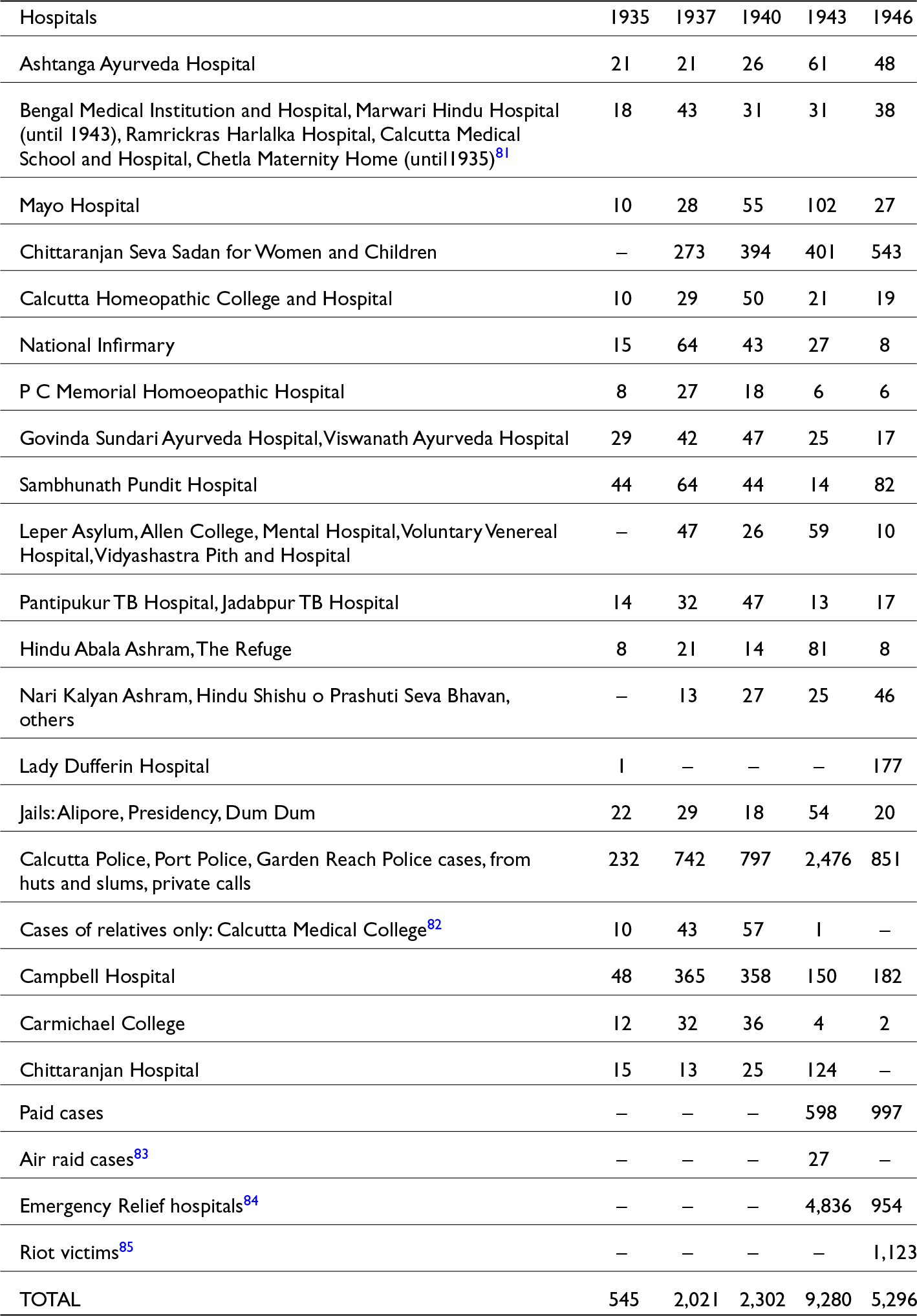
Roy Chowdhury was decidedly anti-Gandhi, yet his pragmatic collaboration with prominent Gandhians illustrates the ambivalent genesis of Hindu communal practices in Calcutta and across India. This collaboration demonstrates why the HSS succeeded. While Roy Chowdhury’s forte lay in rhetoric and land management within the CMC, Khaitan, Birla, and Himatsingka played a crucial role in disentangling health administration from municipal control, allowing private charities like the HSS to take on some of its work. The collaboration proved to be extremely successful: most hospitals with HSS members in their administrative boards sent unclaimed corpses in their hospitals to the charity, instead of the municipal crematorium, thereby validating HSS’s claims with a steady supply. Table 1 highlights the growth and density of this collaboration.
List of hospitals and the number of bodies they supplied to the HSS, 1935–1946Footnote 80

Table 1 Long description
The table lists hospitals and other sources that supplied bodies to the HSS from 1935 to 1946. Calcutta Police and related cases consistently provided the highest numbers, with a significant peak in 1943 at 2,476 bodies. Emergency Relief hospitals also showed a notable increase in 1943, supplying 4,836 bodies, likely due to famine deaths. Riot victims contributed 1,123 bodies in 1946, reflecting the impact of communal violence. Chittaranjan Seva Sadan for Women and Children showed a steady increase, reaching 543 bodies in 1946. The data highlights fluctuations in body supply, influenced by historical events such as air raids and riots, and the varying contributions from different hospitals and institutions.
Before the HSS, hospitals usually sent those who died unclaimed to either the medical college and schools, or to the police in medico-legal cases. Ashtanga Ayurveda Hospital and the Marwari Hospital were the first two hospitals to agree to send unclaimed corpses from their morgues to the HSS instead. Himatsingka was a founding member of the hospital’s Board of Trustees. Bhagwan Das Bagla, a Marwari timber merchant from Rangoon, set up the hospital. Himatsingka, Bagla’s solicitor, further leveraged his connections to the municipality, transforming the hospital into a profitable institution.Footnote 86 At the Marwari Hospital, Himatsingka collaborated with Jamini Bhushan Roy, an indigenous Ayurvedic practitioner from the Khulna District of East Bengal. When he founded the Ashtanga Ayurveda Hospital in 1916, he added Himatsingka to the management board. Himatsingka and Nalin Chandra Paul were members of the Governing Body of the Marwari Hospital when they founded the HSS. Himatsingka’s engagements with Calcutta’s hospitals continued to expand. When Bhushan Roy’s family donated his property to establish the Tuberculosis Hospital, Himatsingka helmed its management.Footnote 87 Himatsingka’s intimate knowledge of the hospitals’ challenges in disposing of dead bodies, coupled with Roy Chowdhury’s first-hand awareness of the crematorium’s issues, proved crucial.
A similar story unfolds with the prominent solicitor D. P. Khaitan’s involvement as a liaison between hospitals and the HSS, as well as the relationships between HSS members and multiple modalities of provincial and nationalist politics. D. P. Khaitan became the municipal representative of the Governing Body of Chittaranjan Seva Sadan and Hospital in 1931 and ensured that the hospital sent its unclaimed bodies to the HSS.Footnote 88 Khaitan often donated to the Bengal Congress, and his donations and long-term work with the Congress would earn him a seat in the Drafting Committee of the Indian Constitution in 1950. Khaitan stopped being a board member of the HSS in 1933, but he remained a general member and continued to provide financial support to the charity.
Many other ordinary HSS members also served as board members with management oversight in the listed hospitals. Ram Chandra Sett, a merchant from Murshidabad, became a Governing Body member of Mayo Hospital on Beadon Street in 1931 and was a member of the HSS.Footnote 89 K. S. Mitra, Secretary of the Medical Colleges in Calcutta since 1928, was a founding member of the HSS.Footnote 90 Although not a member of the Congress or the Hindu Sabha, as the Secretary of the Medical Colleges, he had administrative authority over the medical colleges in the city.
While the HSS’s influence over hospital management elucidates, in part, its growing power, its broader popularity can be explained by examining its role in resolving a more practical problem: the transportation of dead bodies from hospitals. The hospitals paid for each dead body that the municipality carried on one of its lorries. But the crematorium had created a financial problem. It had centralized the disposal of unclaimed dead, but each hospital had to pay more for petrol due to Topsia’s distance from most hospitals (see Figure 4). Previously, hospitals could, at their discretion, dispatch bodies to nearby cremation grounds; however, the CMC subsequently mandated that all hospitals send bodies exclusively to the crematorium. The problems arose in discussions of the municipal public health subcommittee. For example, in 1934, Chittaranjan Seva Sadan wrote to the CMC that they wanted to send the bodies of children in their morgue to the nearby Keoratala Ghat instead of Topsia. They clarified that since they did not have dissected bodies and body parts (for which the CMC had made incineration the mandatory process), this was a feasible proposal. The public health officer of the CMC argued that allowing Chittaranjan Seva Sadan to dispose of their unclaimed dead in a regular cremation ground would influence other hospitals, as the hospitals’ fees were essential to maintain the lorry and the crematorium.Footnote 91 The lorry driver received a fixed salary of Rs 80, while the two workers responsible for transporting bodies each received Rs16 per month. In effect, the patronage of private and municipal hospitals at the crematorium was essential for maintaining the public infrastructure.
Map showing the locations of hospitals serviced by the HSS. Geo-referenced on City of Calcutta: Sociological Map (London: Taylor, Garnett, Evans & Co., 1910). Source: Harvard Map Collection, Harvard Library. This map is not to scale and is intended for illustrative purposes only.

Figure 4 Long description
A map of Calcutta with hospital locations marked by pins. The map includes a sociological index listing population groups such as Europeans, Anglo-Indians and various Indian communities. The map is detailed with roads, rivers and city areas, providing a geographical overview of hospital distribution across the city. A legend at the bottom indicates the symbol used for hospital locations.
The HSS addressed the issues of transportation, labour, and costs by reducing the fees hospitals had to pay to the municipality for lorries and labour. It provided transportation and volunteers to collect bodies from hospitals in Nimtala, free of charge. The HSS could afford this, since it received donations from diverse sources, including from Birla, and annual donations from the Hockey Association (buoyed by the Indian hockey team’s gold medal at the 1932 Los Angeles Olympics), the Indian Football Association, and numerous private subscribers. In 1937, the HSS became the trustee of a Shiva temple at the popular Nimtala cremation ghat. It used the generous accumulation of offerings to pay for cremations, cover the salaries of their volunteers, and open a night school for workers at Nimtala. The temple was a tremendous financial boon to the Samity members and allowed the HSS to continue functioning even when individual donations fluctuated. Given the HSS’s role in ameliorating hospitals’ financial and logistical strains regarding unclaimed bodies, most hospitals had become associated with the HSS by the 1940s. The HSS could then shift its priorities, emerging as a popular social organization that engaged with poverty. So far, the focus has been on unclaimed bodies without engaging with the working class. From the 1940s, the focus shifted to the workers themselves.
Crisis as catalyst: The consolidation of the HSS in 1940s Calcutta
The 1940s marked the full realization of the HSS’s founding principles and rhetoric. It displayed its financial stability and robust capacity to meet demand during economic crises and unprecedented moments of mass death, like famines and riots. By 1941, the HSS had extended its focus to Calcutta’s jute mill workers. It opened a branch in Howrah, providing funeral assistance for poor Hindu labourers, and established a presence in jute factories in Jagaddal, Howrah, and Khardaha.Footnote 92 Funerals and marriages represented significant sources of indebtedness for these workers, who often secured high-interest loans from moneylenders for such events.Footnote 93 The HSS charities offered a quicker solution during moments of devastating grief.Footnote 94
The famine of Bengal, however, was a turning point in the HSS’s history. At this moment of unprecedented mass death in Bengal, the HSS managed to expand its existing infrastructure to meet the new demands for death work. The famine in Bengal killed around three million people, leaving many more malnourished.Footnote 95 The HSS’s volunteers increased to almost a hundred. Between July and August 1943, the HSS cremated 4,000 bodies.Footnote 96 Soon, donations started pouring in from concerned residents of Calcutta. Before the famine, the HSS maintained its influence as a service provider to hospitals and municipalities by actively promoting its services through sympathetic board members in hospitals and councillors in the CMC. After 1943, it became known among concerned Bengali middle classes who were otherwise outside the circle of the usual HSS members.
The famine provided the opportunity for the HSS’s ritualistic innovations to become the new norm. The HSS emphasized the rites around death, and anti-Muslim commentary became evident. Earlier rhetoric of promiscuous heaps and blurring of boundaries between the sacred and the profane re-emerged in the discourses around death rituals in 1943. The HSS complained, without citing evidence, that the Muslim League-led Bengal Government had recommended mass cremation in the crematorium to cope with wartime fuel rationing.Footnote 97 The HSS annual report made vivid references to many bodies being indiscriminately stuffed in the incinerator, cajoling its readers to feel anger for the Hindu unclaimed dead. The HSS claimed to ‘rescue’ bodies from such massified cremation by offering a Brahmin and rituals at Nimtala to more than 5,000 corpses from famine emergency hospitals alone.Footnote 98 The HSS’s reports, alongside newspaper reports on the organization, emphasized its capacity to provide rituals to a vast number of unclaimed bodies—an average of 26 bodies each day, four times higher than their pre-famine figures.Footnote 99
The HSS produced numerous images of famine-stricken corpses to highlight and bring into the public imaginary what starvation and death looked like. Its appraisal of its work in 1943 echoed the 1932 manifesto, as seen in sentences such as: ‘our volunteers carried the bodies to Nimtala … each body received the services of a Brahmin, and each body received their final rites in the Ganga’.Footnote 100 Anti-Muslim rhetoric materialized through the assertions of Brahminical practices over bodies to evoke enraging sympathy.
By the end of 1943, prominent newspapers began to cite the HSS and the Muslim charity Anjuman Mufidul Islam as their source of mortality data.Footnote 101 The HSS’s role as the legitimate inheritor of bodies identified as Hindus was confirmed in 1946, as riots ensued and killed thousands of people, many in the vicinity of the charity’s office. The HSS also provided the newspapers with mortality data according to religion. Donations poured in from various organizations and individuals, and the HSS became a household name for newspaper-reading Hindu publics.
The Partition of 1947 consolidated the HSS’s success. Partition had reduced the Muslim population in the Calcutta Municipal Area from 24 per cent of the total population in 1941 to 12 per cent in 1951.Footnote 102 In its 1948 Annual Report, the HSS wrote what was its only (if veiled) commentary on Partition:
After the blood bath of the previous years, the city returned to normalcy with the attainment of Independence in August 1947. Free from the constant risk and danger to which the office and the workers of the Samity were exposed, both on account of the situation of the Samity in one of the worst riot-affected areas of the city and of the nature of the work which the Samity has to perform, the Samity could now give their attention more freely to constructive activities.Footnote 103
Opposition in the Bengal legislature also dissipated. In 1950, the Government of West Bengal passed a resolution that the crematorium would only incinerate dissected body parts, which meant that every other unclaimed corpse identified by the police or prison wardens as Hindu received rituals from the HSS with Brahmin priests, volunteer workers, and cremation along the Nimtala.Footnote 104 The HSS’s campaign now had the support of the legislature.
Conclusion: Post-colonial afterlives
Today, most people in Kolkata have embraced crematorium technology along the river but have not accepted spaces like Topsia for Hindu cremations. While the first two crematoria were located east of the city, all but one are now along the river, in the same traditional cremation grounds where only firewood cremation prevailed in the 1920s and 1930s, such as Nimtala. As such, the HSS successfully altered the space of death in Calcutta, but did not prevent the technology from taking hold of the city’s popular imagination. As this article has demonstrated, the HSS’s critique was not directed at the technology itself, but rather at the labour practices and spatial designations associated with its location. So, today, after almost a century, the HSS’s project can be constituted as a massive and enduring success.
Thus, the anti-crematorium movement’s legacy is not about the dismantling of the crematorium, given that it continued to exist elsewhere. The movement was about giving communal meanings to unclaimed bodies, a category of death that had otherwise escaped community-specific markings. While the existing historiography of caste and community extensively explores the multiple entanglements of bodies within social, economic, and religious systems, this article demonstrates how the specific context of the crematorium also forced the HSS to actively contend with and organize its politics of bodies around questions of space. As a result, the crematorium’s presence, even its negations, reveals the complex interplay between bodies and spaces.
This offers us lessons beyond Calcutta’s history. The spatial logic of communalism is not just rooted in shrines, the river, and other forms of religious and ritual artefacts that also have long-standing pre-colonial histories. The spatial logic of communalism was as much rooted in modern technologies that intersected with bodies and spaces. The colonial state often used these technologies to reduce expenditure by limiting the use of space and mobilizing stigmatized labour. The crematorium offers us one such vivid technology. Caste was central to this formulation, as the logic of caste hygiene and boundary specifically made Hindu solidarity and anti-Muslim rhetoric a spatial and material issue.
Through a study of the caste and communal history of urban space, this article also provides a colonial history of space. The picture of a Hindu spatial and social order that emerged from the Hindu majoritarian narratives around Topsia was akin to how colonial administrators, such as engineers and CIT planners, constructed the space. Their visions, which were also those of the HSS, were limited to imagining Topsia as a site of offensive trade and a space of waste. The colonial vision of Topsia as a site of offensive trade and waste thus offered a foundational framework upon which the HSS could construct its arguments around communal power. Caste-based Hindu majoritarian power, driven by indigenous capitalists, mimicked the fiscal and real-estate logic of colonialism while branding its work as a narrative of tradition, as if returning to an ephemeral root vested in unspecific religious texts and practices.
This history is also about the enduring legacies of urban elite consolidations in support of Hindu nationalism. Roy Chowdhury, G. D. Birla, P. D. Himatsingka, D. P. Khaitan, and many other members of the HSS created enduring landscapes that persist today. Roy Chowdhury proved to have predicted Calcutta’s real estate development. By the 1970s, the Salt Water lakes, and to a lesser extent, Topsia had become a part of Calcutta’s extensive expansion plans.Footnote 105 In the 1990s, the Topsia crematorium was finally shut down, and the CMC installed a new crematorium in Dhapa, where Chowdhury had wanted it to be located in the 1930s. Topsia has become a new space of real estate prospecting, and developments and gentrification continue to mark precarity on Pasmanda and Dalit residents.Footnote 106 The Hindu burial ground still exists in the region, burying the bodies of children, Vaishnava, and Dalit community members. Meanwhile, medical colleges, hospitals, and the police morgue send only the dead that the present-day HSS or the Anjuman have not claimed to Dhapa.Footnote 107
Even today, the anxiety of bodies out of place persists. During the most intensive waves of Covid-19 deaths, social concerns around the crematorium for unclaimed corpses reappeared. Prominent residents of Calcutta were concerned that the bodies of their loved ones would be cremated in the crematorium in Dhapa, rather than with rites in the traditional pyres, even though the pyres in Nimtala now have electric crematoriums.Footnote 108 Social media users participated in these questions. One X (formerly Twitter) user wrote: ‘Why [are] the dead bod[ies] … at Dhapa Maidan? … Three more furnaces must b[e] install[ed] at every Burning ghat like Keoratala, Siriti, Nimtala, etc.’Footnote 109 The spatial argument is clearer, given that Calcutta is one of the few cities in India where most people use incinerators for death rituals, rather than open pyres.Footnote 110 During the Covid-19 pandemic, the name of the HSS came to the forefront again. Even though the present iteration of the charity has no connection to its colonial-era motivations and functions as a distinct entity, its institutional networks bear enduring legacies. It was one of the official service providers for cremations in Calcutta, especially for those who had died of Covid-19.
Acknowledgements
I am grateful to the board members of the present-day Hindu Satkar Samity for its assistance, and to Mr Pradeep Gain and Mr D. Sahoo at Sirity Cremation Ground, who welcomed me to their workspace. Special thanks to the archivists at the Kolkata Town Hall Library. Cole Belmont, director of the Makerspace Consortium at Union College, helped me prepare the maps. Thank you to the anonymous reviewers and the editors of Modern Asian Studies, especially Sumit Guha, for helping me clarify the prose and the arguments of this article. All errors are, of course, mine alone.
Funding statement
Portions of the research on which this article is based were supported by grants from the American Institute of Indian Studies and the Social Science Research Council.
Competing interests
The author declares none.