

In Britain the Early Bronze Age is dated to the period c. 2400–1600 cal bc, and by c. 2100 cal bc copper was being regularly alloyed with up to 10% tin to produce bronze (Timberlake & Marshall Reference Timberlake and Craddock2013). Accompanying the increase in metal use was a search to find more local sources of copper ore, as the scale of production from the Ross Island Mine, Killarney, Eire (O’Brien Reference O’Brien2015) began to decline at the beginning of the 2nd millennium bc. The discovery of major Bronze Age copper mining sites in Britain languished well behind the typological and technological study of metal artefacts, at least until the end of the 1980s, when extensive underground workings dating to the Bronze Age were first reported from the Great Orme Head, near Llandudno in North Wales (James Reference James and Ellis-Jones1988; Reference James1990; Jenkins & Lewis Reference Jenkins, Lewis, Budd, Chapman, Jackson, Janaway and Ottaway1991; Dutton & Fasham Reference Dutton and Fasham1994) and from an opencast mine at Cwmystwyth in West Wales (Timberlake Reference Timberlake1987; Timberlake & James Reference Timberlake and James2018). The surface exploitation of copper ores across western Britain has now been shown to have been more widespread than this, with up to 16 Early Bronze Age mines and prospecting sites identified from the Plynlimon (Pumlumon) district (mid-Wales), the north Wales coast, and the southern Pennines of England (Alderley Edge & Ecton); most of this activity dates to the period c. 1950–1650 cal bc (Timberlake Reference Timberlake and Clark2009; Reference Timberlake and Marshall2014; Reference Timberlake and Mair2016). Mynydd Parys in Anglesey is unusual – and fortunate – in having associated evidence for underground mining.
The present paper describes the underground workings that have been identified, investigated, surveyed, and dated in the Parys Mine. This became possible following the renewal of access to the mines in 1995, their access having been capped in 1980 for insurance reasons (Jenkins Reference Jenkins1995).
The current programme of archaeological investigation has been based on survey work that has enabled a clear distinction to be drawn between the 18th–19th century working and the shallower and earlier fireset/stone tool-worked galleries they intersect, many of which are still plugged by the debris of prehistoric infill. Archaeological excavation at these underground sites has for the most part been limited to the clearing back and the cutting of fresh archaeological sections through their undisturbed fills; the latter being recorded then sequentially sampled for radiocarbon dating purposes (wood and charcoal), the removal of artefacts (stone tools), and the recovery of environmental evidence in the form of sample monoliths taken from the finer-grained sediments.
Following a brief outline of the site’s location, geological context, and more recent mining history, these underground archaeological mine deposits form the subject of this paper.
THE BACKGROUND TO PREHISTORIC MINING ON MYNYDD PARYS
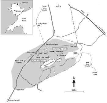
Mynydd Parys (Parys Mountain) is a low (146 m OD) but prominent mountain comprising a band of hard rocks (rhyolites, silicified shales) within the region’s softer rocks (shales). It is located a few kilometres inland, south of the town of Amlwch on the coast of Anglesey (Ynys Môn) in north-west Wales (Fig. 1). The nature of mining on Mynydd Parys in recent times, and indeed in prehistory, relate to the origin, nature, and spatial distribution of various ores. These arise from geological factors described in more detail elsewhere (Pointon & Ixer Reference Pointon and Ixer1980; Bevins et al. Reference Bevins, Patrick, Haynes and Thomas2010; Jenkins Reference Jenkins and Linton2015, 77). The copper mined is mainly in the form of lodes along bedding planes and was formed by volcanic activity some 390 million years ago, but it was also deposited in later veins along fault zones. These lodes consist of the mineral chalcopyrite (CuFeS2) accompanied by quartz (SiO2), often occurring in a fine-grained mixture together with zinc sulphide (ZnS – sphalerite) and minor lead sulphide (PbS – galena) known as ‘Bluestone’ (or in Welsh as ‘Carreg Las’).
Location map for the mines on Mynydd Parys (D. Jenkins)

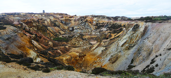
Early references to the mineral deposits here date back to 1607 when Sir John Wynn of Gwydir recorded the presence of copperas (iron or copper sulphate) and brimstone (sulphur) on the mountain; he also noted the existence of ‘a great mineral work’ in 1579 from which Mr Hedley obtained a ‘mineral water’ that made ‘alome and copperas and transmuted iron into copper’ (National Library of Wales 1926, 75–7; North Reference North1962, 60; Harris Reference Harris1964, 19). There is also mention of a mine at ‘Trysclwyn’ in 1698 (Dodd Reference Dodd1926, 92), whilst Lewis Morris (Reference Morris1748, 3–4) refers to the presence of ‘okery earths’ suitable for use as a paint. Rutty (Reference Rutty1761, 470) draws attention to the medicinal value of the iron-rich waters. However, the first industrial scale discovery of copper ores on the mountain was by Charles Roe & Co. of Macclesfield at a place called Golden Venture, recorded (and subsequently celebrated) as being on March 2nd (St. Chad’s Day) 1768 (Harris Reference Harris1964, 22). The excavated ore from these works was carted down to the small harbour at Porth Amlwch that developed concurrently with the mines, and from there it was shipped to Swansea or across to Ravenshead in Lancashire for smelting and sale (Hope Reference Hope1994). In the early Industrial Revolution Mynydd Parys became a major site of mining which briefly dominated world copper production for around a decade at the end of the 18th century (Rowlands Reference Rowlands2002) (Fig. 2). Production reached 44,000 tons of copper ore per annum, surpassing that of Falun in Sweden, which had previously dominated world copper trade. A very useful account of the underground operation and working conditions at the mines at this time is provided by Michael Faraday who visited the Parys Mine during his tour of Wales in 1819 (Tomas Reference Tomas1972, 78–89). By the 1880s, the workforce at Mynydd Parys had shrunk from over a thousand to a few hundred and, in common with other metal mines in Britain; the mines had effectively ceased production (Harris Reference Harris1964).
Mynydd Parys Copper Mines, Amlwch, showing the Parys Opencast (S. Timberlake)

The ores were extracted initially from numerous shallow shafts (approximately 30–40 m deep) that later merged into the two separately owned impressive opencasts seen today (Fig. 1). Mona Mine on the east side was owned by Nicholas Bayly, and Parys Mine on the west jointly by Bayly and Reverend Edward Hughes (Rowlands Reference Rowlands2002). From 1778 the latter was successfully worked for more than a decade by the Parys Mine Company under the management of Thomas Williams of Llanidan, known locally as ‘The Copper King’ (Harris Reference Harris1964). As shallow reserves became exhausted, shafts were developed to extract ore at greater depths up to a maximum of 330 m deep at the northern edge of the ore field. The resulting Parys and adjacent Mona Mines comprise many kilometres of passages, extending to a depth of 156 fathoms (fm) at Gwen’s Shaft, but they are now flooded and inaccessible below the 45 fm level. In the early 20th century, another later minor phase of mine development and ore production took place by John Taylor & Co. Ltd, whilst more recently the mines have been under evaluation by Anglesey Mining plc., through a programme of borehole drilling for possible renewed production of zinc, copper, and minor lead (AMC n.d.).
All access to the underground workings was closed for insurance reasons in 1980 by the sealing of more than 100 shafts and adits with concrete caps. However, it was appreciated that there might be evidence for prehistoric mining within the underground workings, particularly since a hammer stone (then unrecognised as such) had been recovered in the 1970s from an underground site before access was closed. It was used as a convenient door-stop before its significance was recognised, ten years later, as a stone hammer or ‘maul’, which is now considered as a likely indicator of prehistoric mining. Indeed, it was by then appreciated that these underground workings could provide the best opportunity for locating such mining in view of the extensive deep surface cover of later 18th–19th century spoil. In 1995 the Marquess of Anglesey and Anglesey Mining plc kindly granted permission for the footway to Parys mine to be re-opened to allow renewed access to the underground workings for survey and research purposes (Jenkins Reference Jenkins1995, 35).
THE BRONZE AGE WORKINGS AT PARYS MINES
Background
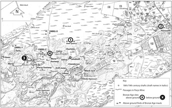
Indications of an ‘earlier’ phase of mining on Mynydd Parys were suggested by Thomas Pennant in 1770 and by Christopher Sykes in Reference Sykes1796 (Sykes Reference Sykes1796, 59; Briggs Reference Briggs1976). Sykes was the first to recognise the form of these fireset excavations and associated spoil dumps containing the characteristic stone tools. Locations of four such sites are recorded on an estate map of 1764 (Hawarden Record Office D/KK/534) and are shown in Figure 3. The prehistoric sites on the mountain so far recorded correspond to three of those identified on the 1764 map (Sites S1, S3 & S4). Site 2, at Henwaith to the east [SH 4506 9075], is located in what is now a private garden, although early 18th century workings have recently been investigated and recorded nearby.
Map of above and below ground Bronze Age sites on Mynydd Parys showing distribution of mauls found on the surface and location of Parys Mine passages in relation to surface features (superimposed on the 1924 OS 25-inch map, including annotations by J. Kenney, D. Jenkins & S. Timberlake)

The observations by Sykes and others prompted a visit by Oliver Davies during his national survey of ancient mines, under the auspices of a committee set up by the British Association for the Advancement of Science in 1935 to investigate the remains of early mining in Wales (Davies Reference Davies1939, 40). His excavation of spoil at Site 1, at Oxen Quarry in the area of Mona Mine just to the north of the summit [SH443906] (see Fig. 3), revealed charcoal-rich sediments containing stone hammers (Davies Reference Davies1939). In 1988 Oliver Davies’s site was located and his original trench re-excavated by the Early Mines Research Group (EMRG) leading to the recovery of more than 30 stone tools together with charcoal fragments (Timberlake Reference Timberlake1988).
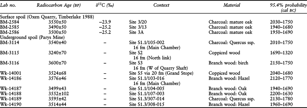
The charcoal subsequently produced three statistically consistent radiocarbon determinations at the 5% level: T’ = 0.8; T’(5%) = 6.0; ν = 2 (Ward & Wilson Reference Ward and Wilson1978), suggesting activity in the first quarter of the 2nd millennium cal bc – the Early Bronze Age (Timberlake Reference Timberlake1989). These have now been supplemented by a further nine dates from workings underground (Table 1). The three other sites recorded on the 1764 map are now buried beneath considerable depths (up to 10 m) of 19th century industrial spoil (Fig. 3). The location and nature of the original ore deposits mined in the Bronze Age is, therefore, not evident. No shallow deposits of ore, nor records of such, have been found in the present study and none have been observed immediately underground. Evidence of small surface excavations that might have provided Bronze Age spoil could be submerged under present-day ponded surface water, and although shallow old workings (Drift Mawr) to the north of the Hillside Opencast (Fig. 3) are recorded, these have not yet been located underground since entry was apparently by shafts that are now capped and inaccessible.
MYNYDD PARYS RADIOCARBON RESULTS (S. TIMBERLAKE, D. JENKINS, & P. MARSHALL)

Dates calibrated using OxCal 4.3.2 (Bronk Ramsey 2009) with Intcal13 calibration curve (Reimer et al. 2013), rounded out to nearest 10 years
The underground prehistoric workings, which are the focus of this report, were discovered when permission to re-open the Parys footway was kindly given by the Marquess of Anglesey (Jenkins Reference Jenkins1995), which led to the subsequent exploration and survey of passages and chambers located on the 16 fm and 20 fm levels in Parys Mine. It should be noted that the fathom level depths related to the original mine datum, which is not now known but is thought to have been 20–25 feet above the current entry of the Parys footway. This means that the 16 fm and 20 fm levels are about 22 m and 29 m respectively below surface. The lowest prehistoric workings are found 8–10 m above the 20 fathom level and probably descended over 13 m below the local Bronze Age ground surface (Oliver Burrows pers. comm.).
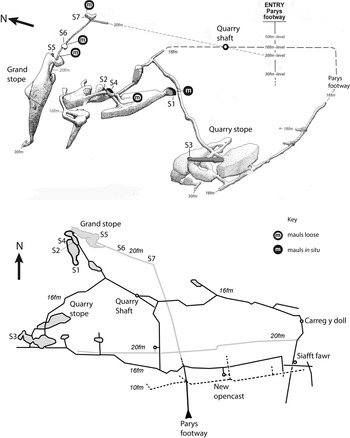
The prehistoric miners recognised outcrops of at least two of the major ore bodies in this area of the mountain, namely the Carreg-y-doll and North Discovery lodes. Two specific underground sites have been identified. The first is an impressive inclined open passage on the Carreg-y-doll lode (Site S3), the second is a cluster of linked workings on the North Discovery lode at the 16 fm level (Sites S1, S2 & S4) together with associated deposits also containing mauls accessible from the 20 fm level (Site S5). Additional prehistoric material has been identified elsewhere on the 20 fm level (Sites S6 & S7), but this has derived from collapse from above rather than being in situ (Fig. 4).
Plan of the 10, 16, and 20 fathom levels with a 3D sketch map (above) of the underground Bronze Age sites (S1–S7) (D. Jenkins)

The morphology of the underground excavations
The distribution and morphology of the underground workings have been established by continuing exploration and survey over the last 15 years, and it is apparent they were originally exposed when intersected by mining ‘stopes’ (work chambers) driven up-dip from the 16 fm and 20 fm levels by 19th century miners (Fig. 4). The workings are not extensive in nature, with a limited passage length of barely 100 m as compared to those, for example, in the Great Orme mines where kilometres of passages have been identified (Jenkins & Lewis Reference Jenkins, Lewis, Budd, Chapman, Jackson, Janaway and Ottaway1991; Lewis Reference Lewis1996). However, only passages intersected by later workings are known and the full extent of the prehistoric workings at Mynydd Parys could be larger than it currently appears (Oliver Burrows pers. comm.). The known passages do indicate that the prehistoric miners were able to mine through hard and resilient rock types such as argillites and silicified stockwork, although they could of course have followed the path of least resistance through joint zones that were both mineralised and easier to remove (such as those seen within the inclined passage in Site S3). Likewise, it appears they were able to mine to a depth of many metres, although actual depths are difficult to measure because of the unknown contemporary ground surface level and the thickness of overlying (ie later) mine spoil. The sum total of this evidence provides a valuable insight into prehistoric mining technique within this distinctive and unusual ore field.
The North Discovery Lode sites
Sites S1, S2, S4, and S5 are clustered around what is described on the 1764 survey (Hawarden Record Office D-KK-534-03) as ‘Old Roman Works’ on the North Discovery lode. This is now indicated by a 5 m deep conical depression in thick surface spoil, but from underground observations it appears to have been a chasm some 20 m by 10 m in size, now filled in by loose recent spoil. Sites S2, S4 and S5 take the form of ‘windows’ intersected by the 18th–19th century workings, whilst at S1 a sizeable work chamber was broken into in the early 19th century, some 10 m from the ‘chasm’. This provides the principal section through the prehistoric spoil, which is described in detail below. Site S2, not certainly proved to be prehistoric, is a small inaccessible cavity in the roof of a passage nearby, whilst S4 is a small roof chamber at the edge of the ‘Roman shaft’ and blocked by its spoil. The ‘window’ located high up in the 20 fm workings (Site S5) is limited to an infilling of spoil of approximately 2 m by 1 m in extent and, from the survey, appears to be at the same level as Sites S1–S4 and only a few metres to the north.
The Carreg-y-doll lode site
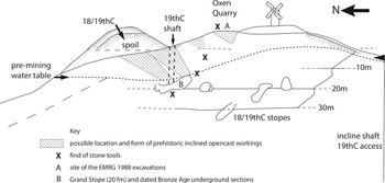
Site S3 on the Carreg-y-doll lode differs from those on the North Discovery lode; here the 18th century workings intersected the bottom of a sloping open passage extending up-dip some 13 m before becoming choked with spoil (Fig. 4). Draughts observed under strong surface wind conditions suggest its choked end must be close to the surface, which survey again locates in an area under surface spoil. A possible model for the working of this type of inclined opencast-drift exploitation is shown in Figure 5.
One suggested method of working from the surface using inclined opencasts (hatched) excavated by firesetting. NB most of the mining will have taken place within the oxidised/supergene zone above the pre-mining water table (drawing S. Timberlake, after Jenkins Reference Jenkins1995, 36)

The deposits
As is common on such sites, the main artefactual evidence is represented by angular rock spoil, the waste product of mining, back-filling, or infilling (through slumping) the excavated workings.
Ore is evident on the roof of the 18th–19th-century work chamber below Site S1 as sinuous quartz veins carrying chalcopyrite, weathering to a green stain of brochantite. However, a 5 kg sample of spoil examined from Site S3 was notably devoid of copper ore, suggesting either the efficiency of its recovery or that the site was excavated for access, not production. The only ore found was a sample of bluestone (the mixed lead/zinc/copper ore). Bluestone was rejected by 18th century miners as too difficult to process, though mined and smelted in the 19th century (Oliver Burrows pers. comm.), so this ore may also have been rejected by the early copper miners.
Spoil may provide evidence of the method of mining and also of any subsequent treatment. Particle size may be restricted in range and shape by the properties of the rock and by the mining procedures involved in ‘development’ work to access the ores; alternatively, where spoil is subsequently redistributed and perhaps mixed, it may lose such characteristics. It may also be modified by in situ ‘weathering’ leading to disaggregation and accumulation of finer grades at the expense of the initial material, and this is particularly true in the very acidic environment of the Mynydd Parys mines: fine products of weathering (ie clay size, <2 μm) may be redistributed to lower horizons. Even the angular coarser spoil is variously enriched in interstitial fine-grained material (hydrous-mica/quartz/jarosite) and iron ochre by weathering or by downwash (‘illuviation’), and this should be taken into account in the interpretation of the results.
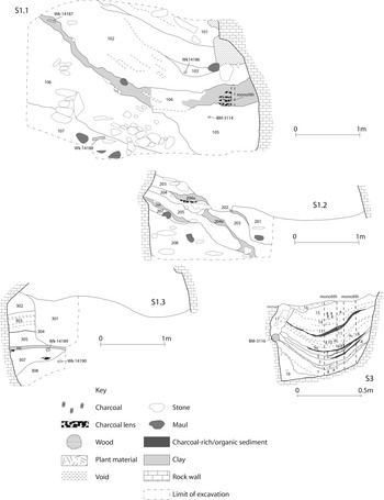
The nature of the spoil is illustrated in the main section S1.1 (Fig. 6). Coarse angular spoil of varying grades is common and mixed/weathered spoil can also be distinguished. In particular, a sample from the base of section S1.1 comprising banded, well-sorted quartz sand (context 107) suggested the residue from some sort of crushing and washing process from which copper ore was removed. Whether this came from work carried out underground, or from sediments washed down into the workings in successive phases from above, is an interesting question. There is clearly useful information to be obtained from the spoil, but such a ‘sedimentological’ approach is still to be applied.
Sections at underground sites S1 and S3 with lab numbers for dated samples marked (D. Jenkins & T. Mighall)

In addition to the sand layer (context 107) in section S1.1, there was also a layer of finely banded clay-silt material ([context 104], S1.1; Fig. 6), which is indicative of ponding during a quiescent spell between two phases of back-filling or natural infilling of the working with a sandier spoil. Various organic remains were identified in this horizon, including acorns, oak leaves, bracken, charcoal and an, as yet unidentified, fibrous material.
Associated artefacts – stone hammers/mauls
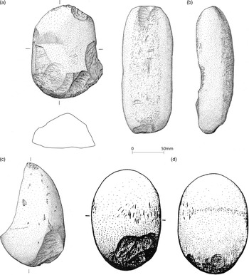
The distinctive artefact of prehistoric mining at Mynydd Parys, as elsewhere, is the stone hammer or ‘maul’ (Fig. 7). The extreme acidity of the mine environment (pH ≤3) would preclude survival of any bone tools, such as those found at the Great Orme. However, it is probable that bone or antler implements were used whose original presence might still be detectable as localised phosphate anomalies retained within the abundant secondary ferric hydrous oxide deposits in the spoil; this is likely due to the low mobility of soluble phosphate anions under the prevailing conditions, a possibility to be tested in a future project.
Hammerstones recovered in 1988 from surface excavations carried out at the Oxen Quarry: (a) Site 3 Trench D (001); (b) split and notched hammerstone re-used from Site 2 surface find; (c) hammer spall surface find; (d) hammerstone with a faint rill around its middle modified to take a handle Site 3 Trench A (drawings by Brenda Craddock)

A sample of 136 ‘mauls’ (or hammer stones) has been collected and examined from the mines, 42 from surface sites and 94 from underground workings: their properties are summarised in Appendix S.1. A dozen examples have been left in situ on the surface and some 50 underground. The surface collection is clustered at particular sites (Fig. 3), recorded as ‘old workings’ on the 1764 map of the mountain, as referred to by Sykes (Reference Sykes1796). These sites have been re-examined and resampled by the EMRG (Timberlake Reference Timberlake1988) and in the present study, and comprise:
-
(a) ‘old spoil’ within the Oxen Quarry excavated by Oliver Davies (Reference Davies1939) and by the EMRG in 1988 (Site 1 on Fig. 3),
-
(b) an area on the outcrop of the Carreg-y-Doll lode near Quarry shaft (see Fig. 3),
-
(c) at the Mona Footway and within the area of the adjacent EMRG surface find clusters (sites ‘Z’, ‘X’ & ‘Y’ [Timberlake Reference Timberlake1988, fig.1]) (Site 4 on Fig. 3), and
-
(d) a site in a private garden at Henwaith which was not sampled (Site 2 on Fig. 3).
Other examples have been found scattered across the northern slopes of the mountain and, rarely, in the Great [Parys] Opencast, but only one maul has been found in Mona Mine, and that was near the surface and may have been introduced during the 19th century (Oliver Burrows pers. comm.). The mauls recovered from underground in Parys Mine have been revealed where 18th–19th century mining on the 16 fm and 20 fm levels broke upwards into shallower Bronze Age workings that exploited both the Carreg-y-Doll and North Discovery Lodes. Underground mauls are generally encrusted with hard iron ochre which has required removal by chemical treatment (dithionite/citrate buffer) before washing to allow detailed examination. The weight, dimensions, and morphology of the samples have been recorded and their petrology examined by stereo-zoom microscopy at × 15–× 75 magnification. However, for the mostly (65%) fine-grained (<1 mm grain size) rock types involved, the petrology is difficult to identify in hand specimen and full confirmation would require thin-section microscopy.
The mauls take the form of very well-rounded cobbles and are mostly of high sphericity, and thus conspicuous underground amongst the angular mining spoil (Fig. 7). These were presumably readily available from till as cobbles eroded by the sea and deposited on beaches. This has been investigated along the north coast of Anglesey and two possible sources so far identified. One is at Porth Helygen [SH 491 908] providing a variety of rock types including porphyries, andesites, and granites, and other unidentified igneous rocks in the Irish Sea till; the other is at Porth Llanlleiana [SH 388 951] providing local Gwna meta-quartzites. Two mauls of distinctive local basal Carboniferous sandstones could be from Llanbedrgoch, some 10 km to the south-east. However, a source for a distinctive pale-buff orthoquartzite used in 16% of the mauls has not yet been identified.
Cobbles would have been selected for their appropriate properties as hammers or ‘mauls’, such as microstructural strength and absence of weaknesses (close jointing, bedding, cleavage, etc.). This is evident in the prevalence of fine-grained homogeneous rock types, often showing sub-conchoidal fractures. The samples have been divided into:
-
(a) nearly whole cobbles,
-
(b) large portions of original fractured cobbles,
-
(c) flakes (one face usually conchoidal),
-
(d) smaller fragments.
The cobbles initially chosen seem to have been dominated by those of small weight showing sub-conchoidal fractures. The sample size includes cobbles up to 2 kg in weight and 150 mm in diameter, but this may be biased toward smaller sizes as a result of the preferential collection of lighter samples from underground sites.
The original use of these cobbles is evident from the flaking and battering of ends, edges, and even faces (for example when used as mortars or anvils [NB the flat face of the stone tool illustrated in Fig. 7b]), whilst over 30% show evidence for re-use in the form of secondary battering upon already fractured faces/edges. Some samples (10%) show evidence of pecking (‘rills’) (Groups 2a–c, Pickin Reference Pickin1990; Type 2A, Timberlake & Craddock Reference Timberlake and Craddock2013) or notches (Groups 3a & b) indicative of attachment to hafts (or possibly ease of use by hand); these results are summarised in Appendix S.1. The groups present within this relatively small sample of 130 are comparable to the somewhat larger examples from Mount Gabriel and the Ross Island Mine in south-west Ireland (O’Brien Reference O’Brien1994; Reference O’Brien2004) and Cwmystwyth (Timberlake Reference Timberlake2003; Timberlake & Craddock Reference Timberlake and Craddock2013). The still larger collection of cobble stone tools (approximately 3500) found at the Great Orme mines appear to be dominated geologically by beach pebbles derived from chilled margins of the ‘micro-diorite’ outcrop at nearby Penmaenmawr to the west of Llandudno, though this assemblage has yet to be studied in petrological detail (Dutton & Fasham Reference Dutton and Fasham1994).
Dating of the deposits
Sites S1, S2, S3, and S5 (see Fig. 4) provided suitable material for nine radiocarbon dates, together with three dates deriving from samples from the surface deposits excavated by the EMRG (Timberlake Reference Timberlake1989) (Table 1). The dates associated with the underground deposits were on samples of burnt wood associated with firesetting and from un-burnt wood associated with slumped-in/washed-in mine sediments. The section locations that the samples were recovered from in S1 are shown in Figure 6.
The radiocarbon dates on charcoal from underground spoil within the mine and from surface spoil at Oxen Quarry clearly fall into a coherent group concentrated in the first half of the 2nd millennium cal bc. The measurements though are not statistically consistent at the 5% level: T’ = 22.8; T’(5%) = 19.7; ν = 11 (Ward & Wilson Reference Ward and Wilson1978), and so they represent more than one episode of mining activity.
Simple visual inspection of the calibrated radiocarbon dates does not allow us to assess the date of mining activity at Mynydd Parys accurately, since the calibration process does not allow for the fact that this group of radiocarbon dates are related – they all come from the same site. Bayesian statistical modelling is required to account for this dependence (Buck et al. Reference Buck, Litton and Smith1992; Bayliss et al. Reference Bayliss, Bronk Ramsey, van der Plicht and Whittle2007), which we have undertaken using OxCal v.4.3 (Bronk Ramsey Reference Bronk Ramsey2009) and the atmospheric calibration curve for the northern hemisphere published by Reimer and colleagues (Reimer et al. Reference Reimer, Bard, Bayliss, Beck, Blackwell, Bronk Ramsey, Grootes, Guilderson, Haflidason, Hajdas, Hatt, Heaton, Hoffmann, Hogg, Hughen, Kaiser, Kromer, Manning, Niu, Reimer, Richards, Scott, Southon, Staff, Turney and Plicht2013).
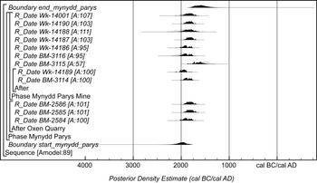
The model (Fig. 8) shows good agreement (Amodel: 89) between the radiocarbon dates and the assumption that the mining activity took place at a uniform rate over a period of time (Buck et al. Reference Buck, Litton and Smith1992). This estimates that mining activity first took place in 2245–1785 cal bc (95% probability; start_mynydd_parys), probably 2085–1890 cal bc (68% probability), and finished in 1815–1300 cal bc (95% probability; end_mynydd_parys), probably 1735–1485 cal bc (68% probability). The dated mining activity is estimated therefore to have taken place over a period of 40–550 years (95% probability) or 175–440 years (68% probability) (Fig. 9).
Probability distributions of dates from Mynydd Parys (P. Marshall). Each distribution represents the relative probability that an event occurs at a particular time. For each radiocarbon date, two distributions have been plotted: one (outline) is the result of simple radiocarbon calibration, and one (solid) is based on the chronological model used. The other distributions correspond to aspects of the model. For example, the distribution ‘start_mynydd_parys’ is the estimate for when mining activity started. The large square brackets down the left-hand side of the diagram and the OxCal keywords define the overall model exactly

Probability distribution for the number of years during which mining activity occurred at Mynydd Parys, derived from the model defined in Fig. 8 (P. Marshall)

The beginning of dated mining activity on Mynydd Parys is clearly earlier than at the Great Orme (94% probability; Fig. 10), where the ores being mined were probably more recognisable (green and blue copper carbonates), and perhaps also more easily extractable and reducible.
Probability distributions of estimates for the beginning of mining activity at Mynydd Parys (derived from Fig. 8) and the Great Orme (derived from the model described in Timberlake & Marshall Reference Timberlake2013, fig. 4) (P. Marshall)

Palaeoenvironmental evidence
Palaeoenvironmental data was collected by T. Mighall and S. Timberlake from sections S1.1 and S3 (Fig. 6) and processed for their pollen (T. Mighall), plant macro-fossils (C. O’Brien) and insects including coleoptera (D.N. Smith & K. Malla). The conclusions are presented here, and the full report is included as Appendix 1.
The S1.1 deposits comprise waste spoil from mining and the back-filling or infilling (through possible slumping) of the excavated workings, as well as possible residue from the crushing and washing process by which copper ore was removed. Whether this came from work carried out underground or from sediments washed down into the workings is not known, yet the radiocarbon dates clearly place these deposits in the Bronze Age. Whilst not directly radiocarbon-dated, the layers of finely banded clay-silt material (context 104) sandwiched in between the dated contexts are indicative of ponding during a period between two phases of back-filling or natural infilling of the workings. The macro- and micro-fossil record for these sediments (in terms of their various species habitat/ecological requirements) clearly supports the idea that the context 104 deposits were washed-in from the surface; either swept into the mine during the course of floods, or else more gradually as water percolated in from the surface.
The seven samples from S3 produced a series of insect faunas that were essentially similar to those recovered from S1.1. However, it is noticeable that the insect remains were recovered in high numbers and were better preserved from higher up the section. This is unexpected and runs counter to the nature of preservation in most archaeological deposits, where preservation usually is best at the base of the material sampled.
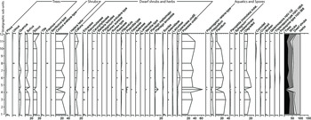
The pollen, macrofossil plant results and insect (beetle) remains confirm that the Bronze Age landscape at Mynydd Parys surrounding the mine was largely open with areas of heathland and wet grassland with some pools of water (Figs 11, 12, 15 & 16). Deciduous woodland was also present, mainly comprising oak and hazel. A permanent decline in woodland was recorded at Site S3 with oak being most affected (Fig. 12). Otherwise, the tree and shrub pollen record is characterised by small-scale fluctuations of oak, hazel, birch, and alder, all known to have been used in prehistoric mines (Mighall & Chambers Reference Mighall and Chambers1993; Mighall et al. Reference Mighall, Chambers, Lanting, O’Brien, Nicholson and O’Connor2000).
Pollen diagram for S1.1, context 104. (T. Mighall). NB both pollen diagrams, drawn using Tilia and Tilia.graph version 2.0.b4 (Grimm Reference Grimm1991–93), are presented as percentages of total land pollen (TLP), excluding spores and aquatics. Spores and aquatics are also expressed as a percentage of total land pollen. A cross denotes one pollen grain. Plant nomenclature follows that of Stace (Reference Stace1991) and takes into account the problems of categorising plant species on the basis of their pollen morphology (see Bennett et al. Reference Bennett, Whittington and Edwards1994). Summary curves for trees, shrubs (constituting arboreal pollen, AP), dwarf shrubs, and herbs (non-arboreal pollen, NAP) are shown

Pollen diagram for S3 (T. Mighall)

Notwithstanding taphonomic and dating issues, the trends shown in the pollen diagrams are similar to those recorded within others taken at prehistoric mining and metalworking sites, particularly in respect of small-scale fluctuations in Quercus, Corylus, Alnus, and Betula (Mighall & Chambers Reference Mighall and Chambers1993; Mighall et al. Reference Mighall, Timberlake, Martínez-Cortizas, Silva-Sánchez and Foster2017). It is possible that these fluctuations were the result of the exploitation of local woodland for timber and charcoal. Interestingly, the permanent decline in tree and shrub pollen at Site S3 contrasts with the evidence from other Bronze Age mines in Wales and Ireland which suggest that the (surrounding) woodland was not severely cleared (Mighall & Chambers Reference Mighall and Chambers1993; Mighall et al. Reference Mighall, Timberlake, Martínez-Cortizas, Silva-Sánchez and Foster2017). It seems that all of these mines, including Mynydd Parys, did not operate in isolation, and agricultural activities, in particular grazing, occurred as part of a dual economy.
Discussion
The recognition of copper ores in the Bronze Age would have been determined by the nature of the landscape and its ecology, and by the distribution and nature of ore exposures. The mineralisation on the mountain is of an unusual nature for Britain, the so-called ‘Kuroko’ type of ore deposit (a synsedimentary polymetallic deposit associated with volcanic activity) leading to inter-bedded seams and scattered pods of rich ore. The host rocks comprise an Ordovician/Silurian inlier of hard fine-grained volcanic rocks (rhyolitic extrusives, intrusives, and pyroclastics) often also intensely silicified in a later phase. These relatively hard rocks within the softer shales were more resistant to glacial erosion, with the result that they produced a low, but prominent, feature, Mynydd Parys, standing at 147 m OD above the generally planated surface of Anglesey at 70 m OD. As a result, Mynydd Parys would have been a prominent hill or landmark within the Bronze Age landscape on Anglesey.
The appearance of exposed ores would again have been a notable feature in an otherwise ‘normal’ environment. Copper deposits can be recognised by the secondary copper minerals produced by weathering, but the distinctive carbonates malachite (green) and azurite (blue) are not stable in the acidic environment of Mynydd Parys, whilst the various sulphates are relatively soluble and would only be preserved within protected cavities and overhangs at the surface and in ‘weathered’ underground workings. In environmental terms, the weathering of the predominant sulphide mineral, iron pyrite (FeS2), results in the production of a very acidic environment (pH ≤3) and of a distinctive sparse vegetation comprised mainly of heather and specialised lichens. It is also worth noting that geologically this type of pyrite rich copper deposit usually weathers to form a gossan, a thick iron-rich oxidised cap from which the copper is then leached downwards to form a layer of secondary copper minerals above the main primary sulphides (chalcopyrite). To what extent the pre-Pleistocene gossan on this mountain was eroded by glaciation to reveal the zone of secondary copper enrichment underneath is unclear.
However, the release of iron and its subsequent oxidation and deposition as a distinctive orange-brown stain upon the exposed rocks would also have been a distinctive feature. Bronze Age metal miners would probably then have needed to locate the weathered sulphide-rich rocks and to recognise the presence of primary and secondary copper minerals within these oxidised sulphide ores.
Yet another means of recognising and possibly also extracting copper during the Early Bronze Age could have been through the burning of the superficial peats accumulated within a number of poorly drained valley sites scattered across the mountain. Such deposits were in fact noted on the 1764 map where the peat was exploited in ‘turbaries’. The chemistry of copper, released into solution by weathering of its sulphide ores in the acidic, anoxic, conditions, is such that it can form a stable metallic precipitate, visibly sheathing plants. This form of deposit was readily exploited in the 18th–19th century at mines such as Dolfrwynog in Coed y Brenin, mid-Wales (Price & Abrahams Reference Price and Abrahams1994, 27). Such distinctive precipitates in any early peats on Mynydd Parys would themselves have attracted attention in the Early Bronze Age and, even more so, any metallic residues left after the burning of such peat.
The intriguing question arises as to which particular ore was extracted during the Early Bronze Age. Various possibilities exist:
-
primary copper sulphide itself (chalcopyrite),
-
secondary enriched copper sulphides (chalcocite and covellite),
-
native metallic copper,
-
secondary red or black copper oxides (cuprite and tenorite),
-
secondary green or blue copper carbonates (malachite and azurite), and
-
secondary coloured copper sulphates (chalcanthite, pisanite).
Of these by far the most usable would have been native copper, although both the carbonates and oxides are relatively easily smelted to metal, and probably the enriched copper sulphides could be smelted although with more difficulty after roasting. By contrast to these secondary copper minerals, the recovery of copper from primary chalcopyrite involves a much more complex smelting process which includes preliminary roasting (oxidation to remove the sulphur) followed by reduction and slagging (for removal of iron) in order to obtain the metal. Whilst it seems unlikely that this was the mineral sought, we should note that sulphides (most probably tennantite but potentially also chalcopyrite) were being mined and possibly smelted at the Beaker-period mine at Ross Island, Killarney several centuries earlier than this (O’Brien Reference O’Brien2004, 472), whilst in France during the Chalcolithic David Bougarit suggests that chalcopyrite was being smelted in small amounts in small domestic-type furnaces (Bougarit et al. Reference Bougarit, Mille, Burens, Carozza, Kars and Burke2002). It has also been suggested this may have been carried out at the time using a non-slagging process (Rostoker et al. Reference Rostoker, Pigott and Dvorak1989; Craddock Reference Craddock1995, 146).
Of the secondary minerals which might be suitable candidates, the brightly coloured carbonates are absent here due to the highly acidic environment, whilst the ephemeral nature of copper sulphates will rarely survive on the surface. However, secondary deposits of metallic copper are generally predictable in peaty anaerobic sites (Krauskopf & Bird Reference Krauskopf and Bird1994), and significant occurrences of native copper were reported by Lentin in 1800 (Rothwell Reference Rothwell2007, 10–12) and before that by Pennant (Reference Pennant1778, 255–6) from the near-surface zone of the Parys orebody, whilst Greenly (Reference Greenly1919, 837) noted the presence of leaf-like or moss-like aggregates of native copper present within the gossan of the Great Lode, as well as from the nearby mine at Rhosmynach, specimens of which are held within the National Museum of Wales collections (Bevins Reference Bevins1994). There also some references to fahlores (tetrahedrite and tennantite) at Mynydd Parys, yet there is no evidence that these were at significant levels (see Rothwell Reference Rothwell2007, 11 [Lentin 1800] & Bevins et al. Reference Bevins, Patrick, Haynes and Thomas2010, 267).
As noted above, chalcopyrite, the main copper ore at Mynydd Parys, is notably sparse within the Bronze Age spoil examined from Site S3, suggesting that either it was not encountered in any great amount within the areas they were working in, or that it had been extracted selectively from these same areas with remarkable efficiency. A sample of Carreglas (bluestone) was, however, recovered from Site S3, possibly after having been discarded by the Bronze Age miners, suggesting that chalcopyrite or perhaps rotten chalcopyrite (here consisting of a mixture of oxidised or enriched secondary copper minerals) was the most likely ore sought. Both the Carreg-y-Doll and North Discovery lodes were exploited in the Bronze Age, whilst no evidence has survived for lodes in the opencast, possibly due to the scale and intensity of later historical operations. The ores currently exposed in the opencast are now mostly dominated by zinc/lead with minor copper; presumably those rich in copper were selectively extracted during the historic/prehistoric period.
The provenance of the copper used to make bronze has variously been suggested on the basis of distinctive trace minor element patterns in metal arising from specific ore sources as discussed by Northover (Reference Northover1980) with respect to Wales. Northover proposed a number of Early Bronze Age metal-types, one of which he considered had its origin in north-west Wales (Group B3), which he identified by its trace element composition As<0.75%, Ni>0.06% and its prevalence alongside other metal types (ie Groups B1, C, & A [as Irish metal]) in the period c. 2200–1600 cal bc. The actual source of this B3 copper was not ever stated, although the implication was that it might include Mynydd Parys. Analysis of such assemblages is complicated by several factors such as trace elements introduced from the alloying with tin (although it forms only 10% of the bronze and is usually considered low in impurities), the mixing of copper metal sources, and the progressive dilution of any signature if bronzes with different copper sources were merged during metal recycling. Even if these were not significant factors, the fundamental problem with the use of ore trace elements at Mynydd Parys is the lack of knowledge and samples of what were the main ores worked in the Bronze Age, as these are needed to establish the presence or absence of distinctive trace elements. However, two samples of the primary copper mineral (chalcopyrite – CuFeS2) at Mynydd Parys have been analysed (Jenkins & Timberlake Reference Jenkins and Timberlake1997), but these lacked distinctive levels of trace elements. Whether this would also be true with the secondary ore minerals that were most likely worked still remains to be established. In addition, no derived copper or bronze artefacts have yet been identified which would allow comparisons of composition.
Lead isotope analysis is another technique used for metal provenance studies and a number of chalcopyrite samples were analysed from Mynydd Parys as part of Rohl and Needham’s (Reference Rohl and Needham1998) major study of ores and metal artefacts. They used a combination of stable lead isotope analysis of the lead content within metal artefacts and ores and the trace element patterns present in the metalwork to define a set of Bronze Age implement metal (IMP-LI) groups which could then be compared with ore sources as defined for the English and Welsh ore fields (EWLIO). Once again, no clear match could be established between any metal group and Mynydd Parys, although chalcopyrite from the Parys Mine was analysed, the ‘best fit’ perhaps being with ores from north-west Wales and Shropshire and the IMP-LI 6 group. This is a metal group characterised by low principal impurities (arsenic, nickel <0.14%; antimony, silver <0.08% with single outliers around 0.2%) and a linear spread of isotope ratios (208Pb/206Pb 2.088–2.103, 207Pb/206Pb 0.849–0.862, 206Pb/204Pb 18.15–18.43; Rohl & Needham Reference Rohl and Needham1998, 91). The best comparison with a Bronze Age metalwork group is perhaps with the Willerby assemblage (1900–1700 cal bc), the latter featuring low flanged stop-bevelled axes contemporary with the Amorico-British daggers and the Wessex 1 Bush Barrow grave series (Needham et al. Reference Needham, Lawson and Green1985; Needham Reference Needham1996).
A specific Mynydd Parys source of Early Bronze Age metal was likewise not defined by Peter Bray in his re-evaluation of evolving metal types in use during the Bronze Age, although he does refer to specific metal types appearing in Wales during the Early Bronze Age (such as DC2 [As] and DC 11 [As +Ni]) which he considers a signal for local exploitation (Bray & Pollard Reference Bray and Pollard2012). The answer here may be to try and identify the exact (mineralogical/ chemical) composition(s) of the ore(s) the Bronze Age miners were removing at Mynydd Parys, by following the same (or a similar) mine-based metal type model Alan Williams (Reference Williams2019) has developed in his investigations of the Great Orme. This approach proved remarkably effective on the Orme, but it will be more difficult to attempt at Mynydd Parys on account of the lack of ore samples and metal artefacts definitely linked to Bronze Age mining combined with very considerable alteration of the mined ore body from that period or its wholesale removal.
Chronological modelling of the 12 radiocarbon dates on samples from the surface and underground suggest that Early Bronze Age mining took place in the first half of the 2nd millennium cal bc, probably starting in 2085–1890 cal bc and ending in 1735–1485 cal bc (68% probability). More dates would be necessary to demonstrate whether this covers the full duration of mining across the site. The most likely scenario is that we are looking at (probably intermittent) underground mining, centred upon the earlier part of this widespread phase of prospection taking place within Western Britain at the beginning of the Bronze Age, but with dates a little later than in central Wales.
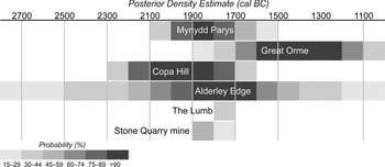
Figure 13 is a schematic diagram summarising the estimate dates when mining activity at sites with three or more radiocarbon dates occurred. The horizontal bars represent the probability that a particular site was in use in a 100-year-period (light shading is less probable, darker shading more probable). Distributions have been taken from the model shown in Timberlake and Marshall (Reference Timberlake and Craddock2013, fig. 4). Mining activity at Mynydd Parys is broadly contemporary with that at Copa Hill, Alderley Edge, and Ecton (The Lumb and Stone Quarry mine) suggesting the main floruit of Early Bronze Age mining took place in the centuries either side of 2000 cal bc.
Schematic diagram showing the periods of use of dated Bronze Age mining sites (P. Marshall)

At Mynydd Parys more dates would be needed to confirm whether the surface workings at the Oxen Quarry were later than the underground ones on the North Discovery and Carreg-y-doll lodes, though this may be difficult to demonstrate as some of the underground material appears to have been transported from the surface. The current chronology therefore provides a fairly robust estimate of the date of Bronze Age mining on the site. We see this same phenomenon of surface material being deposited below ground within the Comet Lode Opencast at Cwmystwyth, but in the latter case these infill sediments were only slightly (or not at all) mobilised, therefore the stratigraphical and chronological sequence appears correct, with the earliest mining debris on the bottom (Timberlake Reference Timberlake2003, fig. 41).
Despite the evidence for Bronze Age mining from both surface and underground contexts, little in the way of further investigation of the mountain for evidence of contemporary settlement or processing sites has ever been attempted, in part due to the extreme level of disturbance encountered, and in part due to the paucity of mapping evidence prior to 1764. However, one possible prehistoric site has been identified on the south-western side of the mountain at Penyfynwent, near the hamlet of Rhosybol, a little distance from the most intensively mined area. The pentagonal earthwork is of unknown date, although it is adjacent to a small, nearly ploughed out, barrow, both perhaps being Bronze Age features. The site was examined by Simon Timberlake as a possible one for further investigation, using either geophysics or geochemistry to detect structures or the evidence for mineral processing or smelting (the latter by means of a geochemical survey of the soil similar to the one carried out on the Great Orme [Jenkins et al. Reference Jenkins, Owen, Lewis and Millard2001]), but to date none of this has been pursued. Due to ill health, the principal author of this paper (Jenkins) has been unable to continue with the fieldwork programme at present. However, in support of this project, further survey and excavation by the current investigation team is planned for the coming years in order to locate and examine sites of potential archaeological interest within the vicinity of the mountain, both above and below ground.
Despite the strong evidence for Beaker–Early Bronze Age settlement and burial in Anglesey during the suggested period of the working of the mine (c. 2000–1700 bc), we find no clear indication of any increased density in the distribution of monuments of this period within the north-eastern corner of the island, and for that matter no particular association with Mynydd Parys or the coastline around Amlwch. The same goes for the distribution of contemporary metalwork finds (Lynch Reference Lynch1991, 155, 213). Indirect evidence for Early Bronze Age metalworking centres upon just a few finds from the island, amongst them the Bodwrdin looped spearhead mould (broadly contemporary with mining on Mynydd Parys) and stone metal burnishers such as that from Rhos y Gad, Llanfairpwll. The discovery of slag on burnt mounds uncovered in the Pentraeth area during the excavation of the Shell Oil Pipeline led to the interpretation of these as metalworking sites (White Reference White1977; Lynch Reference Lynch1991, 364). However, the single, small pieces of slag found were most likely intrusive, and these sites were probably typical burnt mounds dating from the Late Neolithic or Bronze Age, with no association to metalworking (Kenney Reference Kenney, Britnell and Silvester2012, 261–2). In short, there is some slight suggestion of local metalworking on Anglesey during the period in question, but as yet no convincing evidence for it.
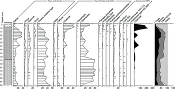
However, a palaeoenvironmental study conducted within the hinterland of Mynydd Parys has provided us with an interesting pollen and geochemical record in the form of a 2 m+ core removed from a bog at Rhosybol on the south-western side of the mountain, just 1.2 km away from the location of Bronze Age mining (Fig. 14; Jenkins & Timberlake Reference Jenkins and Timberlake1997, 87–9). This and a subsequent core have revealed the Holocene history of the site from at least 8330–7580 cal bc (8870±150 bp; Beta-169435). The upper part shows the loss of woodland and pollution resulting from historic mining and smelting, whilst the lower part (from 70 cm down) shows the elevated concentrations of copper, zinc, and lead linked to minor releases of heavy metals generated by mining activity from the prehistoric period onwards (Mighall & Timberlake Reference Mighall and Timberlake2006). The pollen data from this core suggests that the woodland cover is already quite limited between 80 cm and 54 cm and that there is a small decline in tree and shrub pollen at 70 cm. Tree and shrub percentages increase from 54 cm, suggesting increased woodland in the local vicinity – an indication perhaps that any early mining activity or agricultural activities did not have a significant impact on woodlands. However, a more detailed chronology of the core will be needed to fully assess this. Similar geochemical evidence pointing to possible prehistoric-Roman mining was recovered in 1996 from a 2.75 m core drilled through sediments at Traeth Dulas near the mouth of the Afon Goch (Timberlake & Jenkins Reference Timberlake, Jenkins and Millard2001).
Pollen diagram from Rhosybol (T. Mighall & S. Timberlake)

The possibility of Roman mining on Mynydd Parys has been suggested on a number of different occasions by various different authors (Rowlands Reference Rowlands2002, 20). This raises a number of questions, since the evidence from here is in part impressive, and in part circumstantial and indirect. This takes the form of copper cake ingots weighing on average around 20 kg (15–45 kg), some of them 30 cm in diameter and 5 cm thick (RCAHMW 1961). The Historic Environment Record includes 17 sites across Anglesey between which at least 24 copper cake ingots have been found (the number of ingots is not always specified). Four ingots were found on the flanks of Mynydd Parys itself (Stanley Reference Stanley1873, 59–60), and two were recently recovered from the Menai Strait (PRN 38250). Several of these ingots bear a stamp in Roman script upon an embossed dab of copper. However, despite efforts to identify and date possible underground workings in the Parys mines to the Roman period, none have yet been identified, and the current chronology does not extend beyond the Early Bronze Age. Perhaps such workings were located upon other lodes since worked out, for example within the opencasts. None of these though are indicated on the 1764 map, and it would be expected that at least some traces would have been detected underground in the Carreg-y-doll and North Discovery lodes, both of which were worked during the Early Bronze Age. It is relevant that small lead ingots were apparently found within a hearth within the Great Opencast (Pennant Reference Pennant1778), but have since been lost, whilst scraps of highly oxidised folded lead sheeting have been found within spoil near the summit of Mynydd Parys, which are currently under investigation for their nature and age. For the present, however, any mining activity during the Iron Age and Roman times has yet to be identified.
Conclusions
The programme of exploration work undertaken at Mynydd Parys has identified evidence for surface and underground extraction of copper within the first half of the 2nd millennium cal bc, during the Early Bronze Age. The sites are located both on the surface and underground, although at least some of the latter appear to have been reached through the excavation of opencast drifts possibly 10 m or more deep. The excavations would have been undertaken using stone mauls and fire-setting techniques. Animal bone has not survived in the acidic environment, so its use, as at the Great Orme mines, can only be extrapolated from evidence elsewhere.
The chronology indicates a period of exploitation preceding that at the Great Orme, but contemporary with Irish mining and that within mid-Wales. A chronological development of exploitation eastwards, from Ireland to central and north Wales and into north-west England, has been suggested (Timberlake & Marshall Reference Timberlake and Craddock2013).
More work needs to be undertaken to understand the full extent of prehistoric mining at Mynydd Parys, both above and below ground. This needs to be linked to a wider review of the Beaker and Early Bronze Age landscape of north Anglesey. Other avenues of future research might include a combined chemical and lead isotope analysis of ores and local metal as developed by Williams (Reference Williams2019) at the Great Orme despite the inherent difficulties caused by the different chemical composition of the ore deposit. Sedimentological analysis of the spoil deposits could also provide information on the mining processes. Evidence for later exploitation of the mines during the Roman period is still lacking, despite the numerous finds of ‘Roman-style’ copper ingots on Anglesey. Future research on these ingots could include a lead isotope and trace element study and linked to similar studies on the local ores.
The painstaking work to identify the Early Bronze Age workings has provided evidence for the development of copper mining at Mynydd Parys. This makes a major contribution to the relatively small number of extraction sites known, and it fits in well with the chronological model currently being developed. There is considerable potential for future work at this site to further our knowledge of Early Bronze Age mining and to search for the evidence of processing sites and the earliest smelting hearths.
Acknowledgements
This article was researched and written by David Jenkins. The final editing was undertaken by Andrew Davidson and Jane Kenney (Gwynedd Archaeological Trust) and Dr Simon Timberlake (Early Mines Research Group and McDonald Institute, University of Cambridge), who contributed additional background information. Further contributions and corrections were provided by Peter Marshall (Historic England) and Tim Mighall (University of Aberdeen) who oversaw the palaeoenvironmental study. Cadw generously funded the work through grant aid. The suggestion to edit and publish the article came from John Llywelyn Williams, who has worked closely with David Jenkins on this and a number of other significant projects. The editors are also very grateful for the help and encouragement provided by Paul Jenkins (David’s son). Members of the Parys Underground Group, particularly Oliver Burrows, and the Early Mines Research Group have helped source illustrations, provided corrections and comments, and supported the work. Thanks also to Anglesey Mining plc.
Supplementary material
To view supplementary material for this article, please visit https://doi.org/10.1017/ppr.2021.4
APPENDIX 1. PALAEOENVIRONMENTAL DATA (Tim Mighall (pollen), David Smith & Kalla Mal (insects), and Charlotte O’Brien (plant macrofossils))
Palaeoenvironmental data collected from mine spoil heaps, gallery floors, and sediments that accumulate in mines and adits during and after the cessation of activities can all feasibly preserve evidence of human-environment interactions in the mining landscape, including resource-based aspects of mining, such as firesetting and the use of wood fuel, and vegetational changes such as the depletion of local woodland, as well as generating a pollution signal (Burnham et al. Reference Burnham, Burnham and Walker1992; Mighall & Chambers Reference Mighall and Chambers1993; Mighall et al. Reference Mighall, Chambers, Lanting, O’Brien, Nicholson and O’Connor2000; Reference Mighall, Abrahams, Grattan, Hayes, Timberlake and Forsyth2002a; Reference Mighall, Timberlake, Clark and Caseldine2002b; Reference Mighall, Timberlake, Foster, Krupp and Singh2009; Reference Mighall, Timberlake, Martínez-Cortizas, Silva-Sánchez and Foster2017).
Sediments from S1.1 and S3 were targeted for analysis. A monolith was cut from context 104 (Fig. 6; Appx S.2), which has been radiocarbon dated to 3499±43 bp (1940–1690 cal bc; Table 1) that appear to confirm that the sediments are of prehistoric age. Additional bulk samples were obtained from contexts 101, 105, 204, 207, 307, and 308 for plant macrofossil analysis. The latter two contexts have radiocarbon dates of 3595±42 bp (307; 2130–1780 cal bc) and 3514±44 bp (308; 1960–1690 cal bc) placing them in the Bronze Age. A second monolith was taken from S3 (Fig. 6; Appx S.3).
A stratigraphic description of both monoliths is provided in Appendices S.2 and S.3. Each sedimentary layer was assigned a sub-unit number, and a sample from each sub-unit was analysed for pollen using the procedure described by Barber (Reference Barber and Chapman1976), incorporating a density flotation procedure (Nakagawa et al. Reference Nakagawa, Brugiapaglia, Digerfeldt, Reille, De Beaulieu and Yasunda1998). Three hundred land pollen grains were counted for each sub-sample. Pollen was identified with the aid of keys (Andrew Reference Andrew1984; Fægri et al. Reference Fægri, Kaland and Krzywinski1989; Moore et al. Reference Moore, Webb and Collinson1991), photographs (Reille Reference Reille1992), and reference to a modern type slide collection. The results of the pollen analysis are shown in Figures 11 and 12. The data are expressed as percentages of total land pollen (TLP).
Insect samples were processed at the Department of Classics, Ancient History and Archaeology, University of Birmingham, using the standard method of paraffin flotation as outlined in Kenward et al. (Reference Kenward, Hall and Jones1980). Insect remains were sorted and identified under a low-power binocular microscope at magnifications between ×15–×45. Where achievable, the insect remains were identified to species level by direct comparison to specimens in the Gorham and Girling Insect Collections housed at the University of Birmingham. The majority of the insect fauna recovered were Coleoptera (beetles) with a few Hemiptera (true bugs) and Diptera (flies) present. A list of the insects recovered is presented in Appendix S.4. In order to aid interpretation, where possible, taxa have been assigned to ecological groupings, following a simplified version of the scheme suggested by Robinson (Reference Robinson, Jones and Dimbleby1981; Reference Robinson and Jones1983; Appx S.4, column 3). See Appendix S.5 for the proportions of the ecological groups of Coleoptera.
Sub-samples of sediment were disaggregated in cold water and washed through a nest of sieves ranging from 150–500 μm to extract plant macrofossils. The 17 sub-samples from Site S1.1 were 100 ml in volume, while the two from Site S3 (0–30 cm and 30–52 cm) were 200 ml. The wet residues were scanned for botanical remains at up to ×60 magnification using a Leica MZ7.5 stereomicroscope. Fern sporangia were examined at up to ×600 magnification to look for diagnostic spores. Identifications were undertaken by comparison with modern reference material. Plant nomenclature follows Stace (Reference Stace2010). Habitat classifications follow Preston et al. (Reference Preston, Pearman and Dines2002). Results are presented in Appendices S.6, S.7, and S.8.
Sites S1.1, 1.2, 1.3; Context 104
Twelve samples were analysed from 11 stratigraphic sub-units for microfossils (Fig. 11; Appendices S.4, S.6–S.8). Two samples were analysed from sub-unit 8; sub-unit 11 contained no pollen. The pollen diagram is characterised by the regular occurrence of tree and shrub pollen. Corylus avellana-type is well represented along with Quercus, Betula, and Alnus. Pinus, Ulmus, Tilia, and Fraxinus are recorded sporadically in trace amounts. Notwithstanding the taphonomic processes that have led to the accumulation of these sediments, these data suggest the presence of a mixed deciduous woodland locally. This woodland contains taxa (such as oak and hazel) commonly used in prehistoric mines, for example, firesetting (Timberlake Reference Timberlake2003). The total percentage of tree and shrub pollen suffers a short-lived decline in the lowest sample of sub-unit 5, and selective declines in Quercus occur between sub-units 5 and 6 and from sub-unit 7 to 8. Corylus avellana-type percentages decrease between sub-units 6 and 7 and sub-units 10 and 11 (along with Alnus). These declines may well be the result of demand for timber and wood by the miners. They are typical of the small-scale, temporary decreases in woodland taxa reconstructed in pollen diagrams close to prehistoric mining and metalworking sites (eg, Mighall & Chambers Reference Mighall and Chambers1993; Mighall et al. Reference Mighall, Chambers, Lanting, O’Brien, Nicholson and O’Connor2000).
Evidence for trees and shrubs in the plant macrofossil record from S1.1–S1.3 is limited to a few remains of Betula (birch), Rubus (brambles and raspberry), indeterminate bud scales, and sclerotia of the soil fungus Cenococcum geophilum. The latter is an ectomycorrhizal species commonly found in soils of scrub and woodland and has mutualistic associations with certain trees, particularly members of the Betulaceae (birch, alder, and hazel), Fagaceae (oak) and Pinaceae (pine) families (Hudson Reference Hudson1986). Charcoal remains are common in six of the S1 samples, reflecting availability of wood fuel.
The insect fauna from S1.1 is moderately sized, fairly diverse, and dominated by a range of beetles (Coleoptera). This includes a limited number of taxa associated with woodland: Agathidum sphaerulum, which is associated with rotting wood and timbers, and Cylindronotus laevioctostriatus, which is found under the bark or in the rotting wood of oak, beech, and in the decayed stumps of heather. The members of the Haltica genus are normally associated with willow or heather.
Wet, acidic grasslands were also part of the mosaic of vegetation in and around Mynydd Parys. Poaceae percentages are well represented in each sub-unit, with a suite of herbaceous pollen taxa present in low percentages throughout the S1.1 sedimentary sequence including Cyperaceae, Caryophyllaceae, Apiaceae and Succisa, indicative of fen/marsh (Brown et al. Reference Brown, Carpenter and Walling2007). This is supported by the plant macrofossil record from S1.1–S1.3 which comprise a broadly similar range of plant remains, largely deriving from open grassland and wetland habitats. Damp ground communities with Juncus sp (rushes), Carex sp. (sedges), and Rorippa sp. (yellow-cress) are represented, with low occurrences of Sphagnum leaves reflecting mire vegetation. A single oosporangium of the submerged aquatic Chara sp. (stonewort), coupled with rare records of emergents Typha sp. (bulrush) and Schoenoplectus lacustris (common club-rush), and the trace occurrence of Potamogeton natans-type pollen, indicates the presence of plant species associated with small pools of standing water.
Damp open grassland, meadow, and/or grazed pasture are additional features of the landscape, as reflected by plant macrofossil records of Poaceae (grasses), Leontodon sp. (hawkbits), Cerastium sp. (mouse-ears), Potentilla sp. (cinquefoils), Prunella vulgaris (selfheal), and Ranunculus sp. (buttercups). Ruderals including Persicaria lapathifolia (pale persicaria) and Plantago major (greater plantain) would have favoured open disturbed habitats, with Chenopodium sp. (goosefoots) and Urtica dioica (common nettle) indicating areas of relatively nutrient-rich soils.
A noticeable peak in Ranunculaceae, Potentilla-type, and Plantago lanceolata, which are indicative of disturbed ground and pasture, is also observed in the lowest sample from sub-unit 5 in the S1.1 pollen record and coincides with the decrease in the percentage of tree and shrub pollen. Changes in the percentages of these taxa and the presence of others, including Lactuceae, Rumex sp., and Polygonum aviculare-type, and the occurrence of coprophilous dung fungi, Tripterospora-type (HdV-169A), and Podospora-type (HdV-368) (van Geel et al. Reference Geel, Buurman, Brinkkemper, Schelvis, Aptroot, van Reenen and Hakbijl2003), suggest that humans were exploiting local grasslands, possibly for grazing. Calluna also exceeds 5% (of total land pollen) and this may well be derived from heather that still colonises the spoil deposited on Mynydd Parys today.
Bracken, a fern of moorland and hill pasture, is represented in most of the samples by both sporangia and frond fragments and would have been well suited to the acidic soil conditions of the site. Notably large numbers of bracken (and moss) remains are present in context 104 (sub-unit 6 & 7; Appx S.6), the most species diverse sample from Site S1.1. Bracken may have provided a useful resource to former inhabitants of the site, as the dry, brown fronds in autumn make a good fuel, and fresh fronds were useful for packing and flooring material (Gale & Cutler Reference Gale and Cutler2000).
The beetle fauna also contains a number of taxa that are associated with species of plants from open areas, grassland, or disturbed ground (group ‘g’ in Appx S.4 & Fig 15) consistent with the pollen evidence. Typical of these taxa are Apion spp., Sitona hispidulus (associated with melilots – Melilotus spp.), Sitona cylindricollis (associated with clover – Trifolium spp.), and Gymnetron spp. (associated with plantains – Plantago spp.). The ‘dor beetle’ Geotrupes spp. is usually associated with animal dung in heathland, rough grassland, and sandy areas (Jessop Reference Jessop1986). Most species of Choleva and Barypeithes are found associated with the roots of grass and mossy areas. Many of the Carabidae ‘ground beetle’ recovered, such as Trechus quadristriatus, Pterostichus madidus, and Calathus spp., are associated with heathland or chalkland and Amara equestris is particularly associated with stony or sandy ground in heathland or chalkland environments (Lindroth Reference Lindroth1974; Luff Reference Luff2007). A small number of water beetles such as Hydroporus spp. and Cyphon spp. were also recovered.
The proportions of the aquatic ecological groups (Coeleoptera [beetle]) from Mynydd Parys (D. Smith & K. Mal)

Site S3
The upper (0–30 cm) and lower (30–52 cm) plant macrofossil samples from Site S3 (Fig. 12; Appx S.8) comprise largely similar vegetation communities with a greater number and diversity of macrofossils present in the upper sample. A number of herbaceous taxa in the upper plant macrofossil sample are characteristic of areas of open grassland, pasture, and disturbed ground. The species are similar to those recorded for Site S1.1, with the additional presence of Rumex sp. (docks) and Aphanes sp. (Parsley-pierts) in the plant macrofossil record and taxa such as Plantago lanceolata, Rumex, Potentilla-type, Lactuceae, and Brassicaceae consistently found in the pollen record.
Although a number of taphonomic processes may have been involved in the formation of the organic deposits within the mine, it is interesting to note that a significant proportion of the plant remains from both sites are indicator species for the use of grassy moorland turfs from archaeological deposits, as defined by Hall (Reference Hall2003). In particular, bracken, mosses, and heather are frequent elements, with Potentilla, Leontodon, Prunella vulgaris, Ranunculus, Rumex, Viola, and Cenococcum geophilum listed as characteristic above and below ground species. Turfs were used for a variety of purposes, and it is feasible that locally-cut turfs were brought into the mine as packing material or for retaining water.
Calluna and Ericaceae pollen and macrofossils are abundant, suggesting that ericaceous plants have become well established locally. However, both decline from sub-unit 11 in the pollen record as Poaceae, Potamogeton natans-type, and Equisetum all increase dramatically. The latter two taxa are indicative of open water and/or very wet conditions. Abundant Callitriche sp. (water-starwort), which occurs with a minor element of Lemna sp. (duckweed) in the plant macrofossils, indicates shallow pools of temporary or permanent water. Associated damp ground taxa, predominantly comprising species of Juncus and Rorippa, occur in the plant macrofossil record. Taxa such as Filipendula, Apiaceae, and Cyperaceae are regular members of wet grassland/rough meadow communities and are present particularly in the upper sub-units of the S3 pollen record.
Beetle species associated with rough grassland and open areas occur in some numbers. Typical of this kind of landscape is the range of ground beetles recovered such as the Carabus, Trechus, Calathus, and Amara species (Appx S.4). A number of species such as the ground beetle Trichocellus placidus and the weevil Trachyphloeus alternans are associated with sandy open areas, often within chalkland and heathland, with the latter species sometimes associated with rock rose (Helianthemum nummularinum Mill). Other species commonly occur on plants within rough grassland; for example, Apion frumentarium is associated with docks, Alophus triguttatus, Gymnetron spp. with plantain (Plantago spp.), and Sitona hispidulus with clover (Trifolium spp.). There is also some indication for heather in the area, since this is the food plant of the small weevil Micrelus ericae. Very small numbers of Aphodius spp. dung beetles were recovered from samples at sub-unit 11 at Site S3, which suggests that grazing animals may have been present.
Cenococcum geophilum, Betula, and Rubus in the plant macrofossil record provide evidence for scattered trees and shrubs and scrub/woodland soils. Initially total tree and shrub pollen percentages are similar to those recorded at S1.1. However, they decline permanently to less than 25% TLP by sub-unit 3 in S3 and remain around that value until they drop slightly once again between sub-units 14 and 15. Quercus is most adversely affected. Corylus avellana-type is the dominant shrub taxa fluctuating between 5% and 10% TLP. Small fluctuations also affect Alnus and Betula, but the percentages of both taxa show minor increases between sub-units 7 and 11 (Fig. 12). The permanent loss of Quercus may well be related to its use in the mine, especially as herbaceous pollen associated with pasture and/or disturbed ground also decline. The increased presence of heathland, suggested by higher percentages of Calluna and Ericaceae, replaces woodland as the major type of local land use. Given the much lower percentages of arboreal pollen in this section, it is possible that it represents a different and probably later time period than S1.1.
There is also evidence for trees or woodland in the area in the beetle record. Both Agathidium atrum and A. sphaerulum are associated with decaying wood, leaf litter, and moss in woodland. Cylindronotus laevioctostriatus was also recovered in some numbers at Site S3 and indicates the presence of rotting wood and heather stems. The wood boring scolytid Dryocoetes villosus was recovered at 38–30 cm (Appx S.4, sub-units 9A–6) and is associated with a wide range of hardwood trees and is more likely to occur on live trees than timbers.
Discussion
The S1.1 deposits comprise waste spoil from mining and the backfilling or infilling (through possible slumping) of the excavated workings, as well as possibly residue from the crushing and washing process by which copper ore was removed (Fig. 6: S1.1). Whether this came from work carried out underground, or from sediments washed down into the workings, is unknown, but the radiocarbon dates clearly place these deposits in the Bronze Age. While not directly radiocarbon dated, the layers of finely banded clay-silt material (context 104) sandwiched between the dated contexts are indicative of ponding during a period between two phases of backfilling or natural infilling of the workings.
The macro- and micro-fossil records support the idea that the context 104 deposits were washed-in from the surface. The pollen, plant macrofossil, and insect faunas recovered clearly have an origin outside of the mine. There has been little intensive research into the beetle faunas from cave and mine sites but a few species have been recorded from both the thresholds and interior of underground systems. It appears that a number of ground beetles such as Trechoblemus micros (Hbst.) and Trechus fulvus Dej., the staphylinid Quedius mesomelinus (Marsh.), and the catopid Choleva spp. have been recorded regularly in caves (Cambrian Caving Council 2010), but such taxa are noticeably absent from the Mynydd Parys insect faunas. This suggests that these faunas along with pollen and plant macrofossils have probably been swept into the mine, possibly during floods or more gradually as water percolated from the surface. These insects, pollen, and plant macrofossils suggest, therefore, that the area around the mine itself was mainly open grassland and rough ground with some limited woodland.
It is not clear how representative these assemblages are of the surrounding landscape. The beetle faunas are comparatively small (with a minimum number of individuals ranging between two and 145 identifications, representing between two and 41 different taxa), and there are issues over how these insects’ remains and the macro- and micro-fossils may have entered the mine and their resultant taphonomy. Despite these reservations, it appears, generally, that there are fewer insect species associated with woodland towards the top of the deposit than lower down (Fig. 16). Taken at face value, this provides limited evidence to support a progressive clearance of the landscape over this period of time, which broadly confirms the results of the pollen analysis.
The relative proportions of the terrestrial ecological groups (Coeleoptera [beetle]) from Mynydd Parys (D. Smith & K. Mal)

Pollen preservation appears to have been largely unaffected by any transportation process(es). Whilst the condition of pollen grains shows signs of deterioration, identifiable counts of 300 TLP were achieved throughout the sequence (Delcourt & Delcourt Reference Delcourt and Delcourt1980; Jones et al. Reference Jones, Tinsley and Brunning2007). Pollen grain damage (broken, crushed, corroded, and/or degraded) was recorded at both sections S1.1 and S3, with crushing and degradation most likely caused during transportation in water. Some of the corroded, crushed, and broken grains will reflect in-wash and possible reworking of pollen contained within eroded material (cf. Tipping Reference Tipping1987; Wilmshurst & McGlone Reference Wilmshurst and McGlone2005a; Reference Wilmshurst and McGlone2005b). Degraded grains are commonly crushed or crumpled, which also indicates that they have been transported and are then redeposited (Cushing Reference Cushing1967; Lowe & Walker Reference Lowe and Walker1997). Notwithstanding these issues, the proportion of unidentifiable grains is below some of the thresholds suggested for data being unrepresentative from soils (Tipping et al. Reference Tipping, Carter and Johnston1994; Bunting et al. Reference Bunting, Tipping and Downes2001).
The seven samples from S3 produced a series of insect faunas that are also essentially similar to that recovered from S1.1. However, it is noticeable that the insect remains were recovered in high numbers and were better preserved moving up the section. This is unexpected and runs counter to the nature of preservation in most archaeological deposits, where preservation usually is best at the base of the material sampled.
Conclusion
The palaeoenvironmental records from Mynydd Parys confirm that the landscape surrounding the mine was largely open with areas of heathland and wet grassland with some pools of water. Deciduous woodland was present, mainly comprising oak and hazel. A permanent decline in woodland was recorded at Site S3, with oak being most affected. Otherwise, the tree and shrub pollen record is characterised by small-scale fluctuations of oak, hazel, birch, and alder, all known to have been used in prehistoric mines.
Notwithstanding taphonomic and dating issues, trends in both pollen diagrams are similar to those recorded in other diagrams close to prehistoric mining and metalworking sites, in particular small-scale fluctuations of Quercus, Corylus, Alnus, and Betula (Mighall & Chambers Reference Mighall and Chambers1993; Mighall et al. Reference Mighall, Timberlake, Martínez-Cortizas, Silva-Sánchez and Foster2017). It is possible that these fluctuations are the result of exploitation of local woodland for timber and charcoal. The permanent decline in tree and shrub pollen at Site S3 contrasts with evidence from other Bronze Age mines in Wales and Ireland which suggests woodland was not severely cleared (Mighall & Chambers Reference Mighall and Chambers1993; Mighall et al. Reference Mighall, Timberlake, Martínez-Cortizas, Silva-Sánchez and Foster2017). However, all these mines including Mynydd Parys, did not operate in isolation and agricultural activities, in particular grazing, occurred as part of a dual economy.