1. Introduction
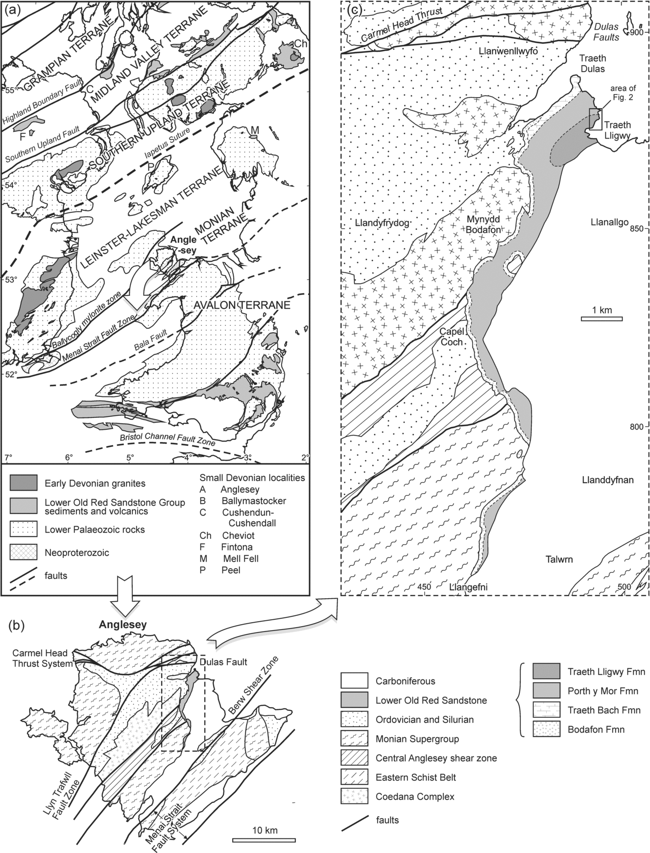
The deformation history of the late Proterozoic to Devonian rocks of the Isle of Anglesey (Ynys Môn), located offshore NW Wales, UK, has promoted debate for much of the past century. Phases of folding and cleavage have been proposed in the late Proterozoic, the early Ordovician, the Silurian, the mid-Devonian and the late Carboniferous, but the severity and succession of phases in any one rock unit remain poorly constrained (e.g. Bates, Reference Bates1974; Barber & Max, Reference Barber and Max1979; Phillips, Reference Phillips1991; Horák & Gibbons, Reference Horák, Gibbons and Carney2000; Hassani et al. Reference Hassani, Covey-Crump and Rutter2004; McIlroy & Horák, Reference McIlroy, Horák, Brenchley and Rawson2006). Important evidence in this debate is provided by some 8 km2 of unfossiliferous red beds (Fig. 1b, c), attributed to the Lower Old Red Sandstone Group (e.g. Greenly, Reference Greenly1919; Allen, Reference Allen1965). To their west, the red beds lie unconformably on various older units along their 10 km long outcrop: late Proterozoic gneisses and granite (Coedana Complex), Cambrian and possibly early Ordovician metasediments (Monian Supergroup), the Central Anglesey Shear Zone, and Ordovician to Silurian metasediments (British Geological Survey, 1980) (Fig. 1c). This unconformity is poorly exposed locally. To their east the red beds are themselves unconformably overlain by the early Carboniferous Basement Beds and Clwyd Limestone Group (British Geological Survey, 1980).
(a) Geological setting of Anglesey amongst Lower Palaeozoic terranes of southern Britain and Ireland; Lower Old Red Sandstone outcrops are marked. (b) Simplified geological map of Anglesey (after Horák & Gibbons, Reference Horák, Gibbons and Carney2000). (c) Geological map of part of eastern Anglesey, showing the Old Red Sandstone outcrop (after Allen, Reference Allen1965), in relation to older and younger units (modified after British Geological Survey, 1980).

A number of authors have recognized that the Anglesey Old Red Sandstone is folded and locally cleaved (e.g. Greenly, Reference Greenly1919; Allen, Reference Allen1965; Barber & Max, Reference Barber and Max1979). However, the intensity of this deformation has been understated, as it comprises two anticline–syncline pairs, one with a strongly overturned middle limb (Treagus, Reference Treagus2008, p. 143). We describe these major folds, their associated minor folds, and an axial-planar cleavage. The section of interest is 150 m long (Figs 1c, 2), and is exposed almost continuously in cliffs up to 6 m high and in part on foreshore outcrops beneath the cliff; the latter are subject to periodic sand cover. Inland exposure is very poor. The intensity of the deformation calls into question its proposed link to Variscan fault displacements (Bates, Reference Bates1974), whilst the angular unconformity below the Old Red Sandstone precludes the deformation being part of a continuous ‘late Caledonian’ phase (e.g. Barber & Max, Reference Barber and Max1979; Howells, Reference Howells2007). We discuss the probability that the deformation of the Old Red Sandstone correlates with the Acadian phase in mainland Wales (Woodcock & Soper, Reference Woodcock, Soper, Brenchley and Rawson2006). This hypothesis has the important implication that the pre-Old Red Sandstone units on Anglesey also record a post-Llandovery (early Silurian) contractional deformation that is largely absent in mainland Wales.
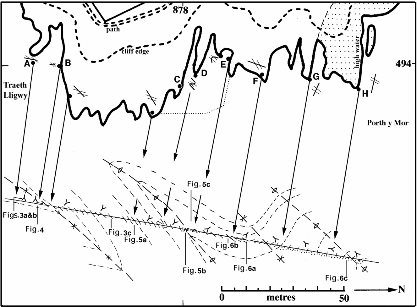
Map and cross-section of the coast on the north side of Traeth Lligwy. Ornamented area in north is the Porth y Mor Formation; the heavy line on the map is the high water line at the base of the cliff along which most of the observations (A–B, C–D, etc), described in the text, were made. The heavy dots along the coast indicate key points where bedding/cleavage relationships were established; these are illustrated by synoptic drawings which are cross-sections viewed to the west, the heavy line indicating bedding attitude and the pairs of lighter lines approximating to cleavage attitudes. These relationships are translated (arrowed lines) on to the cross-section below, where the four major folds are reconstructed with heavy interrupted lines marking their axial planes. Short lines indicate the dip of bedding in the areas of outcrop along the shore; the ‘Y’ symbols (tail points to younger rocks) indicate key points where the direction of younging could be established. The dotted line northeast of localities C–E approximately embraces an area of scattered outcrop on the foreshore, among which observations of the anticlinal hinge area were made.

2. Regional geological setting of the Old Red Sandstone
Anglesey lies south of the suture marking the Silurian closure of the Iapetus Ocean (Fig. 1a). It is part of the collage of terranes thought to have accreted against the Gondwana supercontinent in Proterozoic time (e.g. Cocks & Torsvik, Reference Cocks, Torsvik, Gee and Stephenson2006). The largest piece of this collage is the Avalon terrane, comprising Proterozoic basement overlain by a Cambrian to Early Devonian succession deformed by the Acadian event in the mid-Devonian. The Menai Strait fault system separates the Avalon terrane from the outboard Monian composite terrane of which Anglesey forms a part. This terrane comprises late Proterozoic gneisses and granite (Coedana Complex), Cambrian to possibly early Ordovician metasediments (Monian Supergroup), and related shear zones, including a blueschist belt (Fig. 1b) (McIlroy & Horák, Reference McIlroy, Horák, Brenchley and Rawson2006). It continues southwestward to the Rosslare Complex of southeastern Ireland (Fig. 1a). Outboard again from the Monian terrane is the Leinster–Lakesman terrane. This terrane (Barnes et al. Reference Barnes, Branney, Stone, Woodcock, Brenchley and Rawson2006) exposes no Proterozoic basement, being dominated by Cambrian to Silurian successions assumed to be deformed in the mid-Devonian Acadian event.
The main terrane-scale displacements between and within the Monian and Avalon terranes have been regarded as latest Proterozoic (570 to 550 Ma, Ediacaran) during a phase of oblique subduction beneath the Gondwana margin (McIlroy & Horák, Reference McIlroy, Horák, Brenchley and Rawson2006). However, evidence for a Cambrian age of much of the Monian Supergroup (e.g. Collins & Buchan, Reference Collins and Buchan2004; McIlroy & Horák, Reference McIlroy, Horák, Brenchley and Rawson2006) implies significant later displacements, most probably in the early Ordovician. Early Ordovician displacements are proved along the Ballycogly mylonite zone (Fig. 1a), near the outboard boundary of the Monian terrane with the Leinster–Lakesman terrane in SE Ireland (Murphy et al. Reference Murphy, Anderson, Daly, Gallacher, Graham, Harper, Johnston, Kennan, Kennedy, Long, Morris, O'Keefe, Parkes, Ryan, Sloan, Stillman, Tietzsch-Tyler, Todd and Wrafter1991).
The Lower Old Red Sandstone Group was deposited in latest Silurian and Early Devonian time, probably over wide areas of the terranes south of the Iapetus Suture (Fig. 1a). However, it is only preserved in any volume on the southern part of the Avalon terrane (Fig. 1a; Allen, Reference Allen1979). The more extensive former presence of the Lower Old Red Sandstone across the Avalon terrane and on the Monian and Leinster–Lakesman terranes has been inferred from its sedimentary recycling into Devonian sediments (Allen, Reference Allen1962; Allen & Crowley, Reference Allen and Crowley1983), and from the high Acadian metamorphic grades in Silurian rocks, requiring several kilometres of post-Silurian overburden (Soper & Woodcock, Reference Soper and Woodcock2003).
The only two likely remnants of this missing overburden are on Anglesey and on the Isle of Man (Peel Sandstone Group) (Fig. 1a). The Anglesey sequence has been correlated lithologically with the Lower Old Red Sandstone of South Wales (Allen, Reference Allen1965), and the Peel Sandstone has a palaeomagnetic signature, microflora and trace fossils indicating an Early Devonian age (Crowley et al. Reference Crowley, Briggs, Piper and Morrissey2009; Piper & Crowley, Reference Piper, Crowley, Woodcock, Quirk, Fitches and Barnes1999). Coarser red bed units in NW England – the Mell Fell and Polygenetic conglomerates – are undated, but contain cleaved lower Palaeozoic clasts and are inferred to be post-Acadian and therefore Upper Old Red Sandstone (Stone et al. Reference Stone, Millward, Young, Merritt, Clarke, McCormac and Lawrence2010).
The interpretation of the Anglesey and Peel Old Red Sandstone in terms of regional deformation history will be discussed later in this paper. At that stage it will be relevant to note further outcrops of Lower Old Red Sandstone northwest of the Iapetus Suture, in the Southern Uplands terrane (Fig. 1a). These units sit unconformably on the thrust, folded and cleaved Ordovician and Silurian rocks of the Southern Uplands accretionary complex (Trewin & Thirlwall, Reference Trewin, Thirlwall and Trewin2002). Further northwest again lie the extensive outcrops of Lower Old Red Sandstone in the Midland Valley terrane.
3. The Lower Old Red Sandstone succession
The Old Red Sandstone of Anglesey was described by Allen (Reference Allen1965) in terms of four formations (his ‘beds’). The lowest two units are exposed northwest and west from Lligwy Bay. The sub-Old Red Sandstone unconformity is overlain first by conglomerates and pebbly sandstones of the Bodafon Formation, then by siltstones and calcretes of the Traeth Bach Formation (Fig. 1b). The Lligwy section itself exposes the thickly interbedded pebbly to fine-grained sandstones and siltstones of the Porth y Mor Formation (cliff section H to G, Fig. 2), overlain by the thinly bedded sandstones and siltstones of the Traeth Lligwy Formation (section G to A). No body fossils are known from the Anglesey Old Red Sandstone succession. Allen (Reference Allen1965) correlated the units lithologically with the Lower Old Red Sandstone of South Wales. The Traeth Bach Formation was specifically correlated with the ‘Lower Marls’, now the Sandy Haven Formation (Hillier & Williams, Reference Hillier, Williams, Brenchley and Rawson2006), and the Porth y Mor Formation with the ‘Dittonian’, now the Gelliswick Bay Formation. The thick calcretes at the top of the Traeth Bach Formation have since been matched to the Chapel Point Limestone Member (Hillier & Williams, Reference Hillier, Williams, Brenchley and Rawson2006), which lies just above the base of the Devonian. The described section is therefore probably all within the Lochkovian Stage of the Devonian.
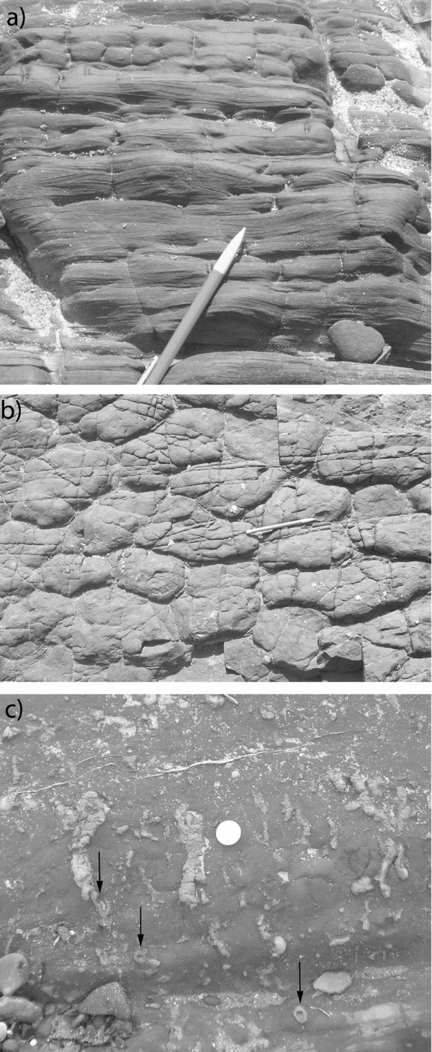
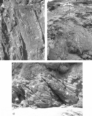
In the Traeth Lligwy Formation, on the right-way-up limbs of the major fold-pairs to be described in Section 4 (A–B and E–H of the map and cross-section of Fig. 2), the sandstone and alternating siltstone beds individually have thicknesses of between 5 and 20 cm, and although affected by gentle folding are laterally persistent for distances of 10 m or more. These sandstones, while mostly parallel-laminated, contain occasional centimetre-scale ripple cross-laminations (Fig. 3a) that provide critical evidence in the structural interpretation described in Section 4. The more mud-rich upper parts of some sandstone beds exhibit polygonal cracks with a contrasting, presumably more sandy, fill that does not penetrate the sand-rich base of the affected beds (Fig. 3b). The polygons are about 10–20 cm in diameter but are flattened parallel to the cleavage–bedding intersection. They are interpreted as desiccation cracks on the subaerially exposed upper surface of sandstone units. They therefore provide independent evidence of way-up to complement that of the ripple cross-lamination.
(a) Right-way-up ripple cross-lamination at location A on Figure 2; the pencil is 14 cm long. (b) Polygonal pattern of desiccation cracks at location B on Figure 2; see Figure 4 for wider context. The elongation of the structures, parallel to the pencil (14 cm long) is parallel to the bedding/cleavage intersection. (c) A surface oblique to bedding illustrating burrows, some of which (arrowed) are interpreted as rhizoliths. Coin is 2 cm across.

The alternating red sandstones and siltstones of the Traeth Lligwy Formation often have a ‘burrowed’ appearance with circular to elliptical cross-sections of tubes of paler red or white siltstone (Fig. 3c). These tubes are up to 4 cm long in cross-section, on surfaces perpendicular to bedding and, as far as can be seen, persist for several centimetres along bedding planes. Other tubes are filled with carbonate or calcareous siltstone. Allen (Reference Allen1965) interpreted some of these as feeding burrows (branched and more common in the sandstones) and as dwelling burrows of organisms (unbranched and more common in the siltstones); they are referred to the Fodinichnia and Domichnia, respectively, of Seilacher (Reference Seilacher1953). Another less common type of ‘tube’ in the siltstones is white and silt-filled but has a central core of carbonate. This type appears in cross-section view, perpendicular to bedding, as approximate circles 1 to 2 cm in diameter, but it is not clear what attitude these tubes have in the third dimension. These are interpreted as calcified root traces or rhizoliths (Klappa, Reference Klappa1980) that developed in semi-arid floodplain sediment. Allen attributed the comparative lack of stratification in the Traeth Lligwy Beds and the presence of burrowing and clay mottling to the activity of bottom-dwelling organisms.
Based on all the facies in the Old Red Sandstone basin of Anglesey, Allen (Reference Allen1965) built up a picture of an alluvial fan starting with conglomerates interfingering with calcareous beds and with cyclical sandstones, including the coarse, large-scale cross-bedded and flat-bedded sandstones of the Porth y Mor Beds. At the top are the younger, non-cyclical, Traeth Lligwy Beds that represent alluvial flood basin deposits, exposed for sufficiently long periods to allow calcrete palaeosols to form in a warm, semi-arid climate.
The re-interpretation of the structure presented in Section 4 affects both Greenly's (Reference Greenly1919) and Allen's (Reference Allen1965) stratigraphic interpretations. Greenly and Allen treat the southern part of the section (Fig. 2, A to D) as a downward, older, continuation of the sequence to the north around a synclinal structure. However, neither author comments on the change of facies that this would involve, with the thick-bedded Porth y Mor Formation having to be equivalent, in part, to the thinner bedded Traeth Lligwy Formation. Greenly (Reference Greenly1919, pp. 585–6, fig. 284) notes that, on the south limb of the syncline, thrusts begin to appear, truncating beds and deforming the calcareous nodules. Allen comments on the thin-bedded nature of the sandstones in the Traeth Lligwy Formation and their comparative lack of ‘mechanical structures’ on the south limb of the syncline. We interpret these features to be the result of tectonic thinning on the overturned limb of the southern anticline as described in Section 4.
4. Structure
The structure of the Old Red Sandstone at Lligwy has previously been described by Greenly (Reference Greenly1919, pp. 578–91) and Allen (Reference Allen1965) essentially as a single, upright, syncline–anticline fold-pair. We show that the southern limb of the ‘syncline’ of those authors contains a major S-facing recumbent syncline–anticline fold-pair (Fig. 2, C–A). This structural re-interpretation provides a solution to the stratigraphic ambiguities described by these authors, as mentioned in the previous Section.
The following description is given under three sub-headings: (a) the two limbs and hinge of the southern syncline; (b) the subsequent anticlinal hinge zone; (c) the second, northern, syncline–anticline fold-pair. The localities described in the following Sections, A–H, grid references [SH 8768 4941] to [SH 8783 4938], are shown on the cross-section and map in Figure 2.
4.a. The southern synclinal hinge and its limbs
The first 20 m of exposure on the foreshore, between localities A and B of the map and cross-section of Figure 2, is part of the southern, right-way-up limb of a major synclinal fold. The outcrop of the northern inverted limb of the syncline, between its hinge area and the subsequent anticlinal hinge area, is shown between localities B and D. Drifting sand, especially between A and B, may obscure some foreshore exposures.
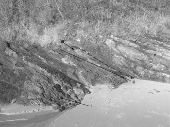
The beds between A and B are flat-lying and, from ripple cross-lamination (Fig. 3a) and desiccation cracks (Fig. 3b), are seen to be right-way-up. Immediately before the main cliff starts, these beds turn up vertically around a synclinal fold (Fig. 4, iii), as shown at locality B in the cross-section to Figure 2, with a steep, N-dipping fault to its north. The fold plunges 20° due east. In the next 80 m of cliff exposure, the dip between localities B and C is at various angles to the north (e.g. 105°/30°–70°N) and the supposition could be made, on the evidence of the syncline core alone, that these rocks are inverted.
The syncline at locality B: (i) right-way-up limb with desiccation cracks on bedding planes; (ii) axial-trace of syncline; (iii) desiccation-cracked surface on overturned steep N-dipping limb; (iv) breccia on steep N-dipping fault; (v) bedding dipping away from observer on overturned, N-dipping limb. View to NW, image width ~ 10 m; map case 25 cm long at location (iii).

A feature of the sandstone beds on this inverted limb between B and C is that they are discontinuous and often have wedge-shaped terminations (Figs 4, 5a); individual beds can be followed for no more than a few metres. In the thinly-bedded sandstones, ripple cross-lamination has been detected at only three locations; at each place the beds are inverted and the foreset/topset angle is small. This is in contrast with their relative abundance, and the easily seen foreset/topset angles, in similar lithologies in the two right-way-up limbs (e.g. Fig. 3a). Most importantly, this observed inversion is supported by the fact that a rough, non-penetrative cleavage is consistently seen throughout this section, in the thin muddy siltstones between the dominant sandstones, to have a shallower dip to the north than the bedding (Fig. 5a).
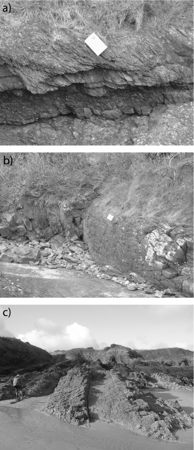
(a) View, looking west, at vertical surface in thinly-bedded, discontinuous, sandstones and thicker siltstones, illustrating the shallower dip of cleavage, parallel to pencil (14 cm long), in the overturned limb of the anticline in (b). (b) The anticlinal hinge, to the south of locality E, plunging east, in desiccation-cracked sandstones; view looking east along the foreshore. The dashed lines marks the hinge line that lies between S- and N-younging beds on the foreshore, to the left and right respectively. Notebook at far end of anticline outcrop is 10 cm wide. (c) Cliff exposure at locality E. Three faults (presumed thrusts) are outlined; fold hinges at (i), (ii), and (iii) are outlined. The beds at (iv) are gently N-dipping with right-way-up ripple cross-lamination (not visible here) at the beginning of the major right-way-up limb of the anticlinal structure, seen in (b). View to west; notebook below (i) is 17 cm long.

Although wedge-shaped terminations to beds are not uncommon in Lower Old Red Sandstone (e.g. Williams & Hillier, Reference Williams and Hillier2004), the discontinuous nature of the thin sandstone beds on this limb contrasts with the continuous, thicker, equivalent beds on the right-way-up limbs (A to B and F to H). This contrast indicates that the succession on the inverted limb has been stretched in the folding process. The apparent scarcity of ripple cross-lamination similarly may be attributed to the tectonic stretching and thinning of these beds.
4.b. The southern anticlinal hinge zone
The foreshore area enclosed by the dotted line shown on Figure 2, between localities D and E, is incompletely exposed. This area contains the hinge zone of the anticline complementary to the syncline discussed in Section 4.a. At the back of the bay between localities D and E, although exposure is incomplete, the sandstones on the inverted limb can be seen to turn through the vertical and then dip northwards through the anticlinal hinge (Fig. 5b), plunging 15°/105°. Some 20 m to the north there is a spectacular exposure of a fold–thrust complex, shown in Figure 5c. Three faults (presumed thrusts) and three tight fold hinges, (i), (ii) and (iii), indicated on Figure 5c, can be distinguished. The northernmost fault of the complex marks the northern edge of the anticlinal hinge zone and the start of the continuous, N-dipping, right-way-up sequence (iv) of sandstones that marks the beginning of the northern syncline. The sole example of cross-bedding that could be distinguished within the complex is at its southern (left-hand) end, and is right-way-up.
In the centre of the foreshore between localities D and E, the anticlinal hinge can be traced through intermittent exposure (Fig. 5b), which is tidal and partly seaweed-covered. Sandstone beds on the south side show inverted ripple cross-laminated beds dipping north at 60°, facing up on the cleavage dipping north at a flatter (e.g. 36°) angle than the bedding. To the north of the trace of the anticlinal hinge zone, right-way-up beds have an undulating flat dip and varying fold plunge both to the east and the west. The exposure is interrupted by faults but the hinge zone can be traced seawards, swinging to a 25° plunge to the southeast (Fig. 2).
4.c. The northern syncline–anticline fold-pair
As the cross-section of Figure 2 shows, the coastal section from E to G comprises a syncline in right-way-up rocks, stratigraphically the equivalent of the inverted sequence B to D. There is plentiful evidence from sedimentary structures of the right-way-up nature of these rocks: ripple cross-laminated beds, desiccation-cracked top surfaces and scours. In silty beds between the dominant sandstones the cleavage dips consistently steeper than the bedding (Fig. 6a), reinforcing the sedimentary evidence. At locality F there is a small anticline overturned to the south with a thrust at its base (Fig. 6b), as described by Greenly (Reference Greenly1919, fig. 382), marking the hinge of the syncline.
(a) Bedding on top limb of the anticline at locality E, above beach surface. Above the lower sandstone breccia, the siltstones exhibit cleavage, dipping north, steeper than the flat beds. Notebook, aligned parallel to the cleavage trace is 17 cm long. (b) Minor anticline in desiccation-cracked sandstone, overturned south above a thrust (visible in right foreground) at locality F. Notebook is 17 cm long. (c) Vertical bedding in the Porth y Mor Formation near the north end of the section at locality H; cleavage in the siltstones in the centre, between the coarse sandstone beds, dips to the north. Person for scale.

On the northern limb of the syncline, from locality G to H, the bedding dip gradually steepens into the northern anticlinal structure. The dip becomes vertical and is locally overturned to dip to the north (locality H, Fig. 6c) with cleavage sympathetically refracting to a shallow northerly dip. Greenly (Reference Greenly1919, p. 587) attributed this apparent rotation of the cleavage to subsequent deformation. Beyond locality H, at the end of the section, the dip flattens over the anticlinal hinge to a near-horizontal attitude. Between localities G and H, there is a distinct change in sedimentary facies, from the Traeth Lligwy Formation into the Porth y Mor Formation, ornamented on Figure 2; the sandstone is coarser and the bed thickness increases from the tens of centimetres in the former to often a metre or more in the latter (c.f. Fig. 6a, b). The contrast of style between the recumbent major fold-pair in the south and this upright fold-pair in the north is attributable, at least in part, to the increase in thickness of beds from the Traeth Lligwy into the Porth y Mor Beds.
5. Discussion: significance of the Lligwy structures
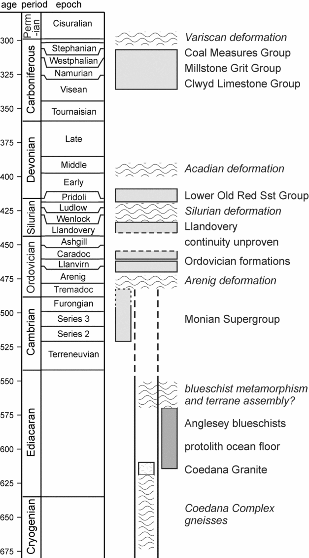
The Lower Old Red Sandstone on Anglesey is evidently more strongly deformed than implied by previous authors. Greenly (Reference Greenly1919) described cleavage and minor tight southward-facing folds in part of the Lligwy section, but neither he nor Allen (Reference Allen1965) recognized the extent of the strongly overturned limb to the southern fold-pair at Lligwy. This strong deformation can be discussed in the context of a chronostratigraphic chart for Anglesey (Fig. 7) showing the age of preserved rock sequences and possible deformation events. There are two possible ages for the deformation of the supposed Old Red Sandstone.
Chronostratigraphic chart showing the age of the main rock units preserved on Anglesey, and the timing of possible deformation events affecting them. See text for discussion.

The first possibility (Bates, Reference Bates1974) is that it records late Carboniferous, Variscan, displacement on the Dulas Faults, 1.5 km to the north of the studied section (Fig. 1b, c). However, the intensity of deformation in the Old Red Sandstone is nowhere recorded in the unconformably overlying Carboniferous rocks. These units are characterized by gentle dips and an absence of cleavage. Only close to major faults such as the Berw Fault (Fig. 1b) are steeper dips locally recorded. The maximum thickness of Carboniferous overburden on Anglesey would only have been about 1500 m (Greenly, Reference Greenly1919), barely compatible with the development of a strong cleavage in the Old Red Sandstone. In any case, the marked angular unconformity below the Carboniferous (Greenly, Reference Greenly1919), overstepping Devonian and Ordovician onto older units (Fig. 1b), records a strong pre-Carboniferous deformation event.
The second possibility, favoured here, is therefore that the Old Red Sandstone records a pre-Visean (early Carboniferous), post-Lochkovian (Early Devonian) deformation phase (Fig. 7). This phase is most likely to correlate with the Acadian event, thought to be responsible for most of the folds and cleavage in mainland Wales and the Lake District. In both these areas, the age of the Acadian phase is now well constrained by K–Ar dating on syntectonic micas to between 400 and 390 Ma, in the later lower to middle Devonian (review by Woodcock & Soper, Reference Woodcock, Soper, Brenchley and Rawson2006) (Fig. 7). Deformation would have occurred when the Anglesey Old Red Sandstone was the basal part of a much thicker and more widespread area of non-marine sediments deposited in the transtensional basins that formed after the late Silurian closure of the Iapetus Ocean (Soper & Woodcock, Reference Soper and Woodcock2003).
An Acadian age for the Lligwy deformation poses several important questions:
(a) Is the Acadian deformation restricted to the Old Red Sandstone or, as seems likely, does it affect older units on Anglesey?
(b) Which structures in the pre-Old Red Sandstone units correlate kinematically with the Acadian structures?
(c) What is the nature and extent of the Silurian (pre-Old Red Sandstone, post-Llandovery) deformation implied by the sub-Old Red Sandstone angular unconformity?
The sedimentary, rather than faulted, unconformable base to the Old Red Sandstone is not in doubt (Greenly, Reference Greenly1919; Allen, Reference Allen1965) and it is therefore necessary that the shortening recorded in this unit is also taken up somewhere in the underlying rocks. The ESE trend of the Lligwy folds is one clue to possible Acadian structures elsewhere, discordant as it is to the NE trend of the main folds in Ordovician rocks below (Bates, Reference Bates1974). On this basis, the most likely Acadian structures in northern Anglesey are those in the Carmel Head thrust belt, which displaces Monian Supergroup and Coedana Complex rocks southwards over Ordovician and Silurian rocks (Fig. 1b, c). This thrust belt strikes ESE in NE Anglesey, then probably divides into a number of splays striking between NE and E in NW Anglesey (Gibbons et al. Reference Gibbons, Tietzsch-Tyler, Horák, Murphy, Gibbons and Harris1994; Horák & Gibbons, Reference Horák, Gibbons and Carney2000). Bates (Reference Bates1974) recognized a number of other thrusts in northern Anglesey associated with the Carmel Head phase.
The southernmost strand of the Carmel Head belt is the Dulas Fault, less than 2 km north of the Lligwy section (Fig. 1c). It is very likely that this thrust front was formerly some kilometres further south, and that Monian or Coedana thrust sheets overlay the Lligwy Bay area. We envisage that thrusting caused the distributed S-directed shear in the thrust footwall that was responsible for the Acadian structures in the Old Red Sandstone. The relatively undeformed nature of the Old Red Sandstone south from Lligwy Bay suggests that the Carmel Head thrusts did not reach much further south, a conclusion supported by the corresponding scarcity of thrusts in Ordovician rocks (Bates, Reference Bates1974).
A number of authors have assigned the post-Ordovician E- or SE-vergent structures on Anglesey to a ‘Caledonian’ deformation envisaged as lasting from late Silurian into Early Devonian time (e.g. Barber & Max, Reference Barber and Max1979; Horák & Gibbons, Reference Horák, Gibbons and Carney2000; Hassani, Covey-Crump & Rutter, Reference Hassani, Covey-Crump and Rutter2004). Our new analysis shows that deformation was not continuous through this time period, but episodic – essentially as recognized by Dewey (Reference Dewey1969). We suggest that the Old Red Sandstone structures record a discrete Acadian phase of S to SSW-verging structures, beginning within the Early Devonian, probably post-Lochkovian, whereas the angular sub-Old Red Sandstone unconformity marks a separate Silurian (post-mid Llandovery) phase (Fig. 7). We present two end-member possibilities for these two deformation phases, and their relative importance:
(a) The Acadian, mid-Devonian, phase is the dominant cause of SE-vergent structures that affect Ordovician to Devonian rocks, and which refold pre-Ordovician structures in the Monian Supergroup. This phase would include the Carmel Head thrust system, all the folds and fabrics in the Ordovician and Silurian rocks, and the later refolding and cleavage of the Monian Supergroup.
(b) The Acadian phase is represented on Anglesey only by the Carmel Head thrust system and some locally related folds and fabrics, such as the SSW-verging structures described here in the Old Red Sandstone and the thrust-related crenulation fabrics in the Ordovician noted by Bates (Reference Bates1974). The more intense and more ductile SE-vergent structures are Silurian in age, not Devonian, and represent deformation events not recorded in mainland Wales or the Lake District.
We favour the second of these two interpretations, as it best explains the strong unconformity below the Old Red Sandstone and the localized deformation within it. The intriguing possibility then arises that the earlier, Silurian, phase records the elusive deformation that occurred during the final closure of the Iapetus Ocean. Over most of England and Wales, Iapetus closure resulted only in a late Silurian change from marine to non-marine facies, and not even in an unconformity. An unconformity does develop below the Old Red Sandstone in South Wales, with Pridoli or latest Ludlow marginal strata overlying Wenlock and earlier rocks (Allen et al. Reference Allen, Bassett, Hancock, Walmsley and Williams1976; Cope, Reference Cope, Harris, Holland and Leake1979). However, this intra-Silurian deformation is not cleavage-forming and is interpreted as transtensional (Hillier & Williams, Reference Hillier, Williams, Brenchley and Rawson2006).
The only other place in Britain southeast of the Iapetus Suture with strong evidence of the Silurian contractional event is the Isle of Man. Here a weakly deformed Old Red Sandstone succession, the Peel Sandstone Group, with Early Devonian palaeomagnetic declinations, microflora and trace fossils (Crowley et al. Reference Crowley, Briggs, Piper and Morrissey2009), is faulted against strongly deformed early Ordovician and mid-Silurian (Wenlock) rocks (Woodcock et al. Reference Woodcock, Quirk, Fitches, Barnes, Woodcock, Quirk, Fitches and Barnes1999). The two main phases of folding and cleavage in the pre-Devonian Manx and Dalby Groups do not occur in the Peel Sandstone Formation, although there are some minor S-directed thrusts (Fitches, Barnes & Morris, Reference Fitches, Barnes, Morris, Woodcock, Quirk, Fitches and Barnes1999). The inference is that these thrusts are Acadian, but that the D1 and D2 deformations in the Isle of Man are late Silurian (Ludlow or Pridoli) in age, possibly comparable with the D1 and D2 deformations on Holy Island, Anglesey (Treagus, Treagus & Droop, Reference Treagus, Treagus and Droop2003). The Peel Sandstone Group would have originally been deposited unconformably over the already deformed Manx and Dalby groups.
A deformation associated with Iapetus closure is, of course, well displayed northwest of the Iapetus Suture in the Scottish Southern Uplands. Here the late Ordovician to at least mid-Silurian accretionary thrust and fold belt was uplifted, eroded and unconformably overlain by Lower Old Red Sandstone by, at latest, Pragian (Early Devonian) time.
6. Summary
(a) The Lower Old Red Sandstone section at Lligwy Bay displays two tight gently inclined anticline–syncline pairs with axial-plane cleavage, rather than the more gentle and upright anticline and syncline previously described.
(b) The folds verge and face upwards to the south, and one of the limbs is strongly overturned on the basis of sedimentary structures and cleavage–bedding relationships.
(c) The probable Early Devonian age of the Lligwy succession, together with an angular unconformity beneath overlying Carboniferous rocks, implies a mid-Devonian deformation that correlates with the Acadian event of mainland Wales.
(d) The Lligwy structures may have developed by shear in the footwall of the Carmel Head thrust zone now cropping out just to the north.
(e) The strong angular unconformity below the Old Red Sandstone implies that the Acadian deformation on Anglesey was predated by a Silurian deformation, possibly related to the closure of the Iapetus Ocean, and perhaps preserved also on the Isle of Man.
Acknowledgments
We would like to thank Geoff Tanner and an anonymous referee for their very thorough and helpful comments on the manuscript.